APPENDIX B: BORING LOGS
|
|
|
- Jasmine Judith Gallagher
- 6 years ago
- Views:
Transcription
1 New Orleans Levee Systems Independent Levee Hurricane Katrina Investigation Team July, 6 APPENDIX B: BORING S As part of the field investigation 9 borings were performed at the sites of interest, as listed in Table B.. The borings were performed by Soil Testing Engineers Inc. between //6 and //6, and 4/7/6 and 4//6. All fieldwork activities were conducted by members of ILIT under the direct supervision of senior members of the team. Two drilling rigs were used for the geotechnical exploration: an F-5 truck-mounted rig with a 5ft tower (CME-75) and an ARDACO bogey rig for sites where access was difficult. Both rigs used 4 mud-rotary wash with a side discharge bit. Shallow borings were initially advanced using a 4-inch diameter auger. A small geoprobe was used to auger down to target depths for Field Vane Shear Testing in sites that were inaccessible by the other two rigs. Three different types of borings were performed: (a) borings for continuous sampling for geologic characterization, (b) conventional geotechnical borings selectively sampled for laboratory tests of engineering properties and (c) borings for providing access for Field Vane Shear Testing. Within the boreholes three types of sampling methods were used: (a) continuous sampling with thin-walled Shelby Tubes (AM D587-) and extruded on site for geologic characterization, (b) undisturbed sampling at selected depths with thin-walled, fixed-piston Shelby Tubes (AM D587-), where the tube mouth was modified to eliminate over-cutting and thus reduce sample disturbance due to rebound (Lunne and Lacasse 994), and (c) disturbed sampling by performing the Standard Penetration Test (AM D586-99), where cohesionless material was present. The progression of the fieldwork program was based on an iterative process between the initial program and the new data as it was being collected from the field. The sampling process initiated with the continuous borings and continuous sampling to obtain a detailed description of the stratigraphy by extruding all samples on-site. Upon completion of each day of fieldwork all boreholes were grouted using cement grout and bentonite pellets. The pages that follow show plan views of the sites at which our investigation team performed borings, showing the locations of each boring. These are followed by the logs of these borings. Each boring log also has local GPS coordinates (x, y, and z) to help to further locate these borings. B -
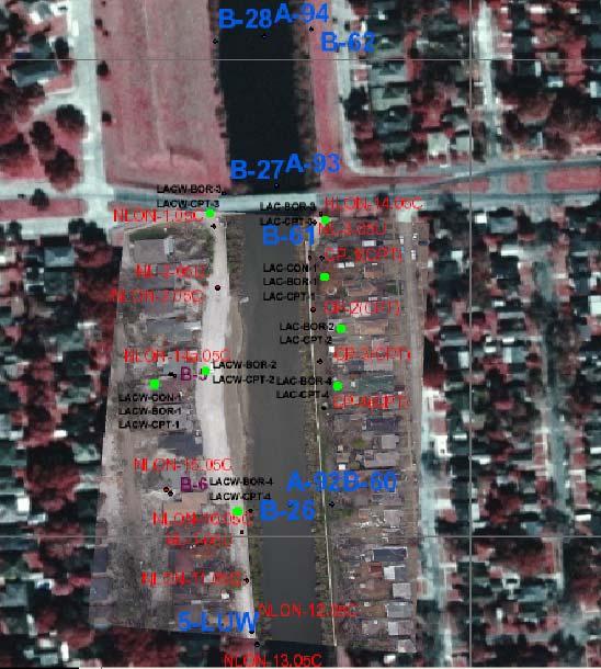
2 New Orleans Levee Systems Independent Levee Hurricane Katrina Investigation Team July, 6 7th REET CANAL BORING Latitude (N) Longitude (W) Elevation (MSL) 7-CON CON CON CON CON-4 A CON CON CON CON CON CON CON BOR BOR BOR BOR BOR BOR BOR-6 A LONDON AVENUE CANAL NORTH, EA BANK BORING Latitude (N) Longitude (W) Elevation (MSL) LAC-CON LAC-BOR LAC-BOR- A LAC-BOR LAC-BOR LAC-BOR Note: Geographic coordinates are based on WGS84 datum. B -
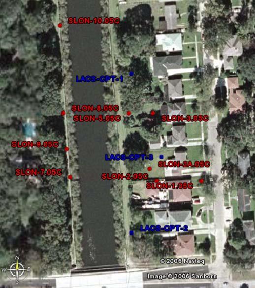
3 New Orleans Levee Systems Independent Levee Hurricane Katrina Investigation Team July, 6 LONDON AVENUE CANAL NORTH, WE BANK BORING Latitude (N) Longitude (W) Elevation (MSL) LACW-CON LACW-BOR LACW-BOR LACW-BOR LACW-BOR LONDON AVENUE CANAL SOUTH, EA BANK BORING Latitude (N) Longitude (W) Elevation (MSL) LACS-CON LACS-CON LACS-BOR LACS-BOR LACS-BOR INNER HARBOR NAVIGATION CANAL, EA BANK BORING Latitude (N) Longitude (W) Elevation (MSL) IHNC-N-CON IHNC-N-BOR IHNC-S-CON IHNC-S-CON IHNC-S-CON IHNC-S-BOR IHNC-S-BOR IHNC-S-BOR LONDON AVENUE CANAL NORTH, EA BANK CPT Latitude (N) Longitude (W) Elevation (MSL) LAC-CPT LAC-CPT LAC-CPT LAC-CPT Note: Geographic coordinates are based on WGS84 datum. B -
4 New Orleans Levee Systems Independent Levee Hurricane Katrina Investigation Team July, 6 LONDON AVENUE CANAL NORTH, WE BANK CPT Latitude (N) Longitude (W) Elevation (MSL) LACW-CPT LACW-CPT LACW-CPT LACW-CPT LONDON AVENUE CANAL SOUTH, EA BANK CPT Latitude (N) Longitude (W) Elevation (MSL) LACS-CPT LACS-CPT LACS-CPT INNER HARBOR NAVIGATION CANAL, EA BANK CPT Latitude (N) Longitude (W) Elevation (MSL) IHNC-N-CPT IHNC-S-CPT IHNC-S-CPT IHNC-S-CPT Note: Geographic coordinates are based on WGS84 datum. B - 4
5
6 BORING 7-BOR- PROJECT NAME 7th Street Canal (East) PROJECT PROJECT LOCATION 7th Street Canal, New Orleans, Louisiana DATE ARTED //6 COMPLETED //6 GROUND ELEVATION -6.5 ft N.A.V.D. HOLE SIZE 4" DRILLING CONTRACTOR E AT TIME OF DRILLING --- GED BY D. Cobos-Roa CHECKED BY A. Athanasopoulos AT END OF DRILLING --- 6' East of driveway of 694 Bellaire Drive CH: Very soft, gray clay. CH: Very soft, gray clay with peat. CH: Very soft, gray clay GEOTECH BH PLOTS ILIT, BORING S, 7TH REET.GPJ GINT US LAB.GDT 4//6 SC: Very soft, fine sand with clay streaks. Bottom of hole at 8.5 feet. 4 9.
7 BORING 7-BOR- PROJECT NAME 7th Street Canal (East) PROJECT PROJECT LOCATION 7th Street Canal, New Orleans, Louisiana DATE ARTED //6 COMPLETED //6 GROUND ELEVATION 4. ft N.A.V.D. HOLE SIZE 4" DRILLING CONTRACTOR E AT TIME OF DRILLING --- GED BY D. Cobos-Roa CHECKED BY A. Athanasopoulos AT END OF DRILLING FILL: Stiff, brown slightly silty clay with stone and gravel FILL: Stiff, dark gray, organic clay to gray and tan clay with /"-" silt layer. CH: Medium, gray clay with silt seams and layers /"-" CH: Soft, dark gray clay with silt seams and organics No Recovery. Re-drive with smaller tube to get disturbed sample. Sample # 7-BOR--4* CH: Gray clay mixing with organic matter. 4* 9 OH: Very fibrous marsh, roots, wood. 5 9 OH: Medium, dark gray organic clay with peat. CL-ML: Soft, gray, slightly silty clay GEOTECH BH PLOTS ILIT, BORING S, 7TH REET.GPJ GINT US LAB.GDT 4//6 CH: Soft, gray clay with alternate layers of fine sand and silt. CH: Soft gray clay with silt seams. Bottom of hole at. feet
8 CLIENT PROJECT UC Berkeley ILIT (Independent Levee Investigation Team) DATE ARTED /6/6 DRILLING CONTRACTOR E GED BY A. Athanasopoulos COMPLETED /6/6 CHECKED BY D. Cobos-Roa PROJECT NAME 7th Street Canal (East) BORING 7-BOR- PROJECT LOCATION 7th Street Canal, New Orleans, Louisiana GROUND ELEVATION ft N.A.V.D. HOLE SIZE 4" AT TIME OF DRILLING --- AT END OF DRILLING --- SC: Brown clayey sand, roots (6"), black/brown clayey fine sand, roots, organic matter (4"), gray/black sand with many roots transitions to light brown sand ("), firm gray clay, signs of shells ("). A Top- SM: Brown silty sand. Bottom- OL: Black organic matter. 5 OL: Marsh, mixing zone, gray CH and OH, transitions to CH. Bottom- CH: Gray clay. 65 Top- CL-ML: Silty, gray clay. CH: Very soft, dark gray clay with wood and shell fragments. 7.. CH: Very soft, gray clay with silty clay layers CH: Very soft, gray clay GEOTECH BH PLOTS ILIT, BORING S, 7TH REET.GPJ GINT US LAB.GDT 4//6 CLS: Very soft, gray, very sandy clay with shell. Bottom of hole at 8. feet
9 CLIENT ILIT (Independent Levee Investigation Team) PROJECT DATE ARTED /7/6 DRILLING CONTRACTOR E GED BY A. Athanasopoulos UC Berkeley COMPLETED /7/6 CHECKED BY D. Cobos-Roa PROJECT NAME 7th Street Canal (West) BORING 7-BOR-4 PROJECT LOCATION 7th Street Canal, New Orleans, Louisiana GROUND ELEVATION 4. ft N.A.V.D. HOLE SIZE 4" AT TIME OF DRILLING --- AT END OF DRILLING FILL: Stiff, tan and brown clay with silt CL-ML: Medium, gray clay with silt and fine sand, alternating layers and traces of organic matter. CH: Medium, gray clay with silt seams and wood. 8.. CH: Soft, gray and brown clay with peat and organics OH: Soft, dark gray organic clay with peat. OH: Medium, dark gray organic clay with peat (roots) CH: Very soft, gray clay. SM-SC: Soft gray silty sand to silty clay (alternate layers) GEOTECH BH PLOTS ILIT, BORING S, 7TH REET.GPJ GINT US LAB.GDT 4//6 CH: Soft, gray clay with alternating layers of silty, fine sand. Bottom of hole at 7. feet
10 CLIENT UC Berkeley ILIT (Independent Levee Investigation Team) PROJECT DATE ARTED /7/6 DRILLING CONTRACTOR E GED BY A. Athanasopoulos COMPLETED /7/6 at the last ', drill rig deviated from vertical CHECKED BY D. Cobos-Roa PROJECT NAME 7th Street Canal (West) BORING 7-BOR-5 PROJECT LOCATION 7th Street Canal, New Orleans, Louisiana GROUND ELEVATION 4. ft N.A.V.D. HOLE SIZE 4" AT TIME OF DRILLING --- AT END OF DRILLING FILL: Very stiff, tan and brown clay with silt. CL-ML: Brown silty clay WOOD: Wood and shells. 4 OL: Dark brown/black organic, half of area is wood. 67 OL: Wood, organic clay. 4 Wood, roots, organic matter. 5 CH: Very soft, gray clay with silt lenses and wood GEOTECH BH PLOTS ILIT, BORING S, 7TH REET.GPJ GINT US LAB.GDT 4//6 CH: Soft, gray clay with alternating seams of silty fine sand. Bottom of hole at 7. feet
11 BORING 7-BOR-6 PROJECT NAME 7th Street Canal (East) PROJECT PROJECT LOCATION 7th Street Canal, New Orleans, Louisiana DATE ARTED //6 COMPLETED //6 GROUND ELEVATION -6.6 ft N.A.V.D. HOLE SIZE 4" DRILLING CONTRACTOR E AT TIME OF DRILLING --- GED BY A. Athanasopoulos CHECKED BY D. Cobos-Roa AT END OF DRILLING --- Sample# 7-BOR-6- was not retrieved so after 7-BOR-6 was completed,moved ~' and sampled 5' to 7' with.5"/". Sample# 7-BOR-6A-. 68 CH: Gray clay, traces of organic matter, shells. CH: Gray clay, silt lenses. Bottom of hole at. feet GEOTECH BH PLOTS ILIT, BORING S, 7TH REET.GPJ GINT US LAB.GDT 4//
12 BORING 7-CON- PROJECT NAME 7th Street Canal (East) PROJECT PROJECT LOCATION 7th Street Canal, New Orleans, Louisiana DATE ARTED //6 COMPLETED //6 GROUND ELEVATION -6.5 ft N.A.V.D. HOLE SIZE 4" DRILLING CONTRACTOR E AT TIME OF DRILLING 4. ft / Elev -.5 ft GED BY D. Cobos-Roa CHECKED BY A. Athanasopoulos AT END OF DRILLING --- 6' East of driveway of 694 Bellaire Drive GEOTECH BH PLOTS ILIT, BORING S, 7TH REET.GPJ GINT US LAB.GDT 4//6 SM: Loose, dark brown, silty fine sand, moist, with occasional root mass, and organic matter. FILL: Very loose, dark brown, silty fine sand, moist, with fine pea-sized gravel. SM: Brown, silty fine sand, moist, with shell fragments. with trace amount of "-.5" subrounded gravel OL: Brown-black organics, moist, trace shells and sand. Changed to 4" mud rotary drill. No Recovery,.5" diameter concrete block. FILL: Shell fill with pea gravel, " to " subangular gravel, and dark brown, very moist silty clay (CH). CH: Gray clay, trace amounts of organic material (fibrous peat), trace of fine angular gravels. CH: Soft, gray clay, thin silt lenses, decreasing fine gravel content. CH: Soft, gray clay, moist, with occasional shells and fibrous material and trace organic matter. medium to high plasticity silt lens at.' and.5'. CH: Gray clay, with shell fragments and silt lens at.5' and.75'. CH: Gray clay, trace of organic matter and decreasing shell content, silt lenses closely spaced. CH: Soft grading to firm, gray clay, with trace of organic matter. " silt pocket at 4.'. CH: Soft to firm, gray clay, with trace organic matter. CH: Gray clay, with trace of organic matter. CH: Very soft, gray clay, trace of silt, very moist. CH: Gray clay. Very soft zone at.6'. CH: Gray clay, grading to stiffer 5.' to 6.'. CH: Gray clay, occasional lens of medium subrounded gray and white sand. Transition layer of soft gray plastic clay (CH), moist. increasing trace of sand and shell fragments. SM: Loose, gray silty sand with clay, moist, trace amounts of shells. decreasing fines content with depth. " diameter Shelby tubes used. Extruded and logged onsite. At 4' depth, changed to rotarty mud drill (4"). 5 bulk samples taken. Bottom of hole at. feet
13 BORING 7-CON- PROJECT NAME 7th Street Canal (East) PROJECT PROJECT LOCATION 7th Street Canal, New Orleans, Louisiana DATE ARTED //6 COMPLETED //6 GROUND ELEVATION - ft N.A.V.D. HOLE SIZE 4" DRILLING CONTRACTOR E AT TIME OF DRILLING --- GED BY D. Cobos-Roa CHECKED BY A. Athanasopoulos AT END OF DRILLING --- MH: Firm, brown silt, moist, with fine sand, organic matter and wood. ML: Moderately stiff, brown sandy silt with clay, moist, with.5"-" thick fine and uniform sand lenses and fine root mass. grading stiffer and sandier as root mass increases WOOD: Damaged tube between 6' and 8'. Changed to 4" diameter mud rotary drill GEOTECH BH PLOTS ILIT, BORING S, 7TH REET.GPJ GINT US LAB.GDT 4//6 OL: Dark brown, organic silt, with partially decomposed organic material, thin to /8" diameter wood fragments. Very strong organic odor. Rapidly loosing fluid in borehole. Water rising from hole or CPT- drilled close by. Bentonite added to boring fluid. CH: Soft, gray clay, moist, with organic matter and partially decomposed wood. strong organic odor. Very moist, clearly increasing plasticity and decreasing organic content and fibrous material. Very soft clay, grading to firmer from about 4.8', trace of fine roots. ML: Medium plasticity, gray clayey silt, grading to stiffer, very moist. CH: Very soft, gray clay, trace of organic matter and roots. ML: Gray, medium plasticity silt. "-" very fine uniform, moist sand lenses. CH: Soft, gray silty clay, high water content. transitions to clayey silt (ML), grading to more firm from 8.5'. Very soft, clay, with "-.5" silt lenses, trace thin wood fragments and roots. grading to stiffer. Firm, light gray to gray clay, moist, with trace organic matter and thin silt lenses. Soft, gray clay, moist, with trace wood and organic matter. High moisture content with partially decomposed wood, strong organic odor. Firm, gray clay, with fine uniform sand lenses.5"-" thick. trace of fresh water (oyster) shells from '-' Firm, gray clay, with silt lenses " thick. transitions to sand, grading stiffer SP: Loose, gray, fine, uniform sand, very moist, with trace of shells. CLS: Firm, gray sandy clay, fine uniform sand pocket from 4'-4.4'. 6 Bottom of hole at 6. feet
14 BORING 7-CON- PROJECT NAME 7th Street Canal (East) PROJECT PROJECT LOCATION 7th Street Canal, New Orleans, Louisiana DATE ARTED //6 COMPLETED //6 GROUND ELEVATION -.7 ft N.A.V.D. HOLE SIZE 4" DRILLING CONTRACTOR E AT TIME OF DRILLING --- GED BY D. Cobos-Roa CHECKED BY A. Athanasopoulos AT END OF DRILLING --- WOOD OL: Dark brown, organic silt, with organic matter, roots, and fibrous material. Root-induced diagonal crack zone at 9.5'. CH: Very soft, gray clay intermixed with black organic silt, saturated, strong organic odor. Transition to gray high plasticity clay, grading to stiffer, moist, with organic matter, roots, and wood. 7 7 Bottom of hole at 4. feet. GEOTECH BH PLOTS ILIT, BORING S, 7TH REET.GPJ GINT US LAB.GDT 4//
15 BORING 7-CON-4 PROJECT NAME 7th Street Canal (East) PROJECT PROJECT LOCATION 7th Street Canal, New Orleans, Louisiana DATE ARTED //6 COMPLETED //6 GROUND ELEVATION -.8 ft N.A.V.D. HOLE SIZE 4" DRILLING CONTRACTOR E AT TIME OF DRILLING --- GED BY D. Cobos-Roa CHECKED BY A. Athanasopoulos AT END OF DRILLING --- Drilled to 9.5' with mud rotary. OH: Intermixing of dark brown, organic silt with fibrous material and organic matter, with gray high plasticity clay (CH). Bottom of hole at.5 feet. 7 GEOTECH BH PLOTS ILIT, BORING S, 7TH REET.GPJ GINT US LAB.GDT 4//
16 BORING 7-CON-4A PROJECT NAME 7th Street Canal (East) PROJECT PROJECT LOCATION 7th Street Canal, New Orleans, Louisiana DATE ARTED //6 COMPLETED //6 GROUND ELEVATION -.7 ft N.A.V.D. HOLE SIZE 4" DRILLING CONTRACTOR E AT TIME OF DRILLING --- GED BY D. Cobos-Roa CHECKED BY A. Athanasopoulos AT END OF DRILLING --- OL: Dark brown, organic silt, very high moisture content, with organic matter and roots, with some gray clays down to 6.8'. OH: Very soft, gray clay mixed with dark brown and black silt (OH), and tan clay (CH), very high moisture content. CH: Grades to stiffer clay, decrease in water content. End of intermixing zone. Gray clay, with trace of organic matter. Bottom of hole at. feet GEOTECH BH PLOTS ILIT, BORING S, 7TH REET.GPJ GINT US LAB.GDT 4//
17 CLIENT UC Berkeley ILIT (Independent Levee Investigation Team) PROJECT DATE ARTED /7/6 DRILLING CONTRACTOR E GED BY A. Athanasopoulos COMPLETED /7/6 CHECKED BY D. Cobos-Roa BORING 7-CON-5 PROJECT NAME 7th Street Canal (West) PROJECT LOCATION 7th Street Canal, New Orleans, Louisiana GROUND ELEVATION 4. ft N.A.V.D. HOLE SIZE 4" AT TIME OF DRILLING --- AT END OF DRILLING --- FILL: Dark brown clay, thin layer of crushed rock, with shells. Wood, concrete followed by stiff, dark brown clay with fine sand. CL-ML: Firm to stiff, gray-brown silty clay with shells. Red-brown, fill material consisting of silty clay GEOTECH BH PLOTS ILIT, BORING S, 7TH REET.GPJ GINT US LAB.GDT 4//6 4 Stiff, gray silty clay, less silty fines. Silty clay, clay includes reddish brown traces. Gray silty clay. CH: Firm to stiff, gray brown clay with reddish traces and shells. Clay, contains mostly crushed shells. SHELL: Shell layer followed by black organic traces. CH: Firm, gray silty clay with silt lenses, grades stiffer with more silt at 9.4'. Brown, medium stiff clay with reddish traces and lower silt content. Gray clay with shells. OH: Organic layer with wood and black organic matter. CH: Medium stiff clay becomes softer before becoming more organic. OH: Black organic matter. WOOD CH: Gray clay with black organic clay. OH: Firm, black clay with wood, silt, strong odor. Dark gray clay with roots, organics wood and roots for the st ", strong odor. " to 6" contains plastic organic clay, shells, and gravel up to " in diameter. CH: Gray clay with wood. Wood at 5.4' Shells, roots, and organics, strong odor. First ' sheared by wood. Large amount of organics and roots throughout. " chunk of wood CL-ML: Silty clay with organics and roots throughout. Very soft up 8.8'. Becomes stiffer silty clay. OL: Organics with wood and odor. CL-ML: Gray, silty clay. Clay is firm until.' where it becomes softer. CH: Gray, high plasticity clay with silt lens at.', becomes more silty after.', traces of black organic throughout and roots at the base of the sample. Gray silty high plasticity clay with silt lenses every few inches. Large silt lens at 4.6'. Stiff, clean plastic clay from 5.' to end. Silt lenses absent in this layer. Clay with wood at 6.' to 6.4'. Stiffer, gray silty clay with silt lenses. Appears to be fine sand mixed into the silt lenses from 7.45' to the end of the sample. Firm, gray, silty plastic clay. Gray, softer clay, " sized gravel at.'. Very soft /" inclusion of plastic clay with high water content in filled root track from.' to.6'. Silt lens at.7', firm, silty clay to the end of the sample. Soft, gray plastic clay with even softer zones surrounding roots. Many shells and filled roots. Shells at.5' that is 5/8" across. This material is very soft, plastic, and has high water content until a silt lens at.8'. Firm clay from.8' to the end. Roots in very soft clay through to 4.5'. Secondary intersitial clay in root tracks, very soft high water content very plastic clay. Stiff clay. Soft root track through clay until 7', highly plastic, high water content in soft filling. Silt lens. SP: Dirty gray sand containing shell particles for last ". Dirty gray, medium grained sand throughout, contains shell fragments. Bottom of hole at 4. feet
18 DRILLING CONTRACTOR E GED BY A. Athanasopoulos 6946 Bellaire Drive UC Berkeley PROJECT DATE ARTED //6 COMPLETED //6 CHECKED BY D. Cobos-Roa PROJECT NAME 7th Street Canal (East) GROUND ELEVATION -6.6 ft N.A.V.D. AT TIME OF DRILLING N/A AT END OF DRILLING --- BORING 7-CON-6 PROJECT LOCATION 7th Street Canal, New Orleans, Louisiana HOLE SIZE 4" TOPSOIL: Organic matter with roots (moist), topsoil and sediments, tan-brownish yellow sand. Brownish yellow sand, topsoil and sediments. Topsoil and sediments. OL: Organic silty matter with tan sand in the middle of cross section, roots. Grading to organic clay, roots, traces of red organic matter, strong odor. CH: Soft, gray clay with traces of organic matter grading to high PI gray clay with roots and shell fragments. Soft, gray clay, shell fragments. Soft, gray clay, silt lens at.4' (~" thick). Soft, gray clay. Bottom of hole at 4. feet GEOTECH BH PLOTS ILIT, BORING S, 7TH REET.GPJ GINT US LAB.GDT 4//6
19 BORING 7-CON-7 PROJECT NAME 7th Street Canal (East) PROJECT PROJECT LOCATION 7th Street Canal, New Orleans, Louisiana DATE ARTED //6 COMPLETED //6 GROUND ELEVATION.8 ft N.A.V.D. HOLE SIZE 4" DRILLING CONTRACTOR E AT TIME OF DRILLING.5 ft / Elev -9.7 ft GED BY D. Cobos-Roa CHECKED BY A. Athanasopoulos AT END OF DRILLING ---.5hrs AFTER DRILLING. ft / Elev -8.4 ft Auger first ' FILL: Medium Firm, tan-brown, sandy clay with silt (CL) and trace amount of roots. Tan and gray clay with silt (CH) and small brick fragments. ML: Light gray, soft clayey silt, moist, with organic matter and roots. OH: Dark brown and black, soft organic silt, moist, with roots and organic matter, trace amount of reddish-brown stains. Dark brown-black very soft organic silt, with trace of fine sand, organic matter, roots and organic odor. Intermixig zone. Dark brown organic silt mixed with very fine gray silty sand (SM), and gray clay (CH), very low density organics (OH). CH: Dark brown and gray clay with lenses of fine gray sand. CL: Soft, gray silty clay, moist, trace amount of roots and organic matter. OH: Very soft, black organic silt, low density, moist, with some gray clay, roots, and organic odor. CH: Intermixing zone. Very soft, dark brown-black organic silt (OH), moisture content increases with depth, mixed with gray clay (CH), and very fine silty sand (SM). Sand horizontal crack on interface. Trace of wood and roots. ML: Very soft, gray, medium plasticity clayey silt, very moist. OH: Very soft, dark brown, fibrous organic silt, very moist, low density, with significant amount of wood and strong organic odor. WOOD OH: Black organic silt, with decomposed organic matter, saturated. WOOD (single core of wood in tube) fragments and roots. CH: Very soft, dark gray and brown, high plasticity clay with fine sand lenses, organic matter and roots. OH: Very soft, black-dark brown fibrous organic silt with trace amount of roots and strong organic odor, transitions to gray clays (CH). CH: Medium firm, gray clay, trace of shells and organic matter. " to " thick silt pockets. Bottom of hole at 9. feet GEOTECH BH PLOTS ILIT, BORING S, 7TH REET.GPJ GINT US LAB.GDT 4//
20 DATE ARTED //6 DRILLING CONTRACTOR E GED BY A. Athanasopoulos UC Berkeley PROJECT COMPLETED //6 CHECKED BY D. Cobos-Roa BORING 7-CON-8 PROJECT NAME 7th Street Canal (East) PROJECT LOCATION 7th Street Canal, New Orleans, Louisiana GROUND ELEVATION -. ft N.A.V.D. HOLE SIZE 4" AT TIME OF DRILLING N/A AT END OF DRILLING --- GP: Stiff, gravel fill, light brown, silty-sandy clay, dark brown clay, traces of black organic CL-ML: Gray-brown clayey silt, interchanging with gray-brown silty clay, layered with brown, red lenses. CLS: Interchanging of medium stiff clay, silt, fine sand in gray, brown, orange, red colors. CH: Brown, gray clay with shells. SP: Very fine sand or silt lens. OL: Black organic matter, fibrous, with roots. OL: Organic matter, fibrous (Marsh). WOOD drilled through wood OL: Black organic matter with roots. CH: Gray clay with silt lenses. OL: Black organic matter, roots and wood, strong odor (Marsh). OH: Contact with clay happens vertically (Marsh). SM: Silty fine sand. CH: Mixing gray clay with black organic matter. gray clay with fine sand clay with roots becomes firmer, silt content increases clayey silt with fine sand, trace roots Bottom of hole at. feet. GEOTECH BH PLOTS ILIT, BORING S, 7TH REET.GPJ GINT US LAB.GDT 4//6
21 BORING 7-CON-9 PROJECT NAME 7th Street Canal (East) PROJECT PROJECT LOCATION 7th Street Canal, New Orleans, Louisiana DATE ARTED //6 COMPLETED //6 GROUND ELEVATION -6.6 ft N.A.V.D. HOLE SIZE 4" DRILLING CONTRACTOR E AT TIME OF DRILLING. ft / Elev -6.6 ft GED BY D. Cobos-Roa CHECKED BY A. Athanasopoulos AT END OF DRILLING --- FILL: Loose, tan, fine, uniform sand (SP), with brick fragments and trace of organic matter. SM: Loose, brown, silty sand, saturated, with organic matter and roots. OH: Dark brown-black organic silt, saturated, with strong organic odor and light brown stains. Extremely soft, black-dark brown organic silt, low density, very high water content, vertically aligned roots and wood fragments, strong organic odor. CH: Transition to very soft, gray clay, high water content, with organic matter and trace of roots. Intermixing zone. Very soft, gray clay mixed with black, soft organic silt (OH), very high water content. Very soft, gray clay with fine sand lenses (" to " thick) with trace amount of organic matter. Bottom of hole at 8. feet GEOTECH BH PLOTS ILIT, BORING S, 7TH REET.GPJ GINT US LAB.GDT 4//6
22 BORING 7-CON- PROJECT NAME 7th Street Canal (East) PROJECT PROJECT LOCATION 7th Street Canal, New Orleans, Louisiana DATE ARTED //6 COMPLETED //6 GROUND ELEVATION - ft N.A.V.D. HOLE SIZE 4" DRILLING CONTRACTOR E AT TIME OF DRILLING --- GED BY C. Cheung CHECKED BY A. Athanasopoulos AT END OF DRILLING --- FILL: Stiff, brown silty clay FILL: Gray, gravelly fill. SC: Light brown to brown, clayey silty sand. SM/SC to CL: Light brown, silty, clayey sand. CH: Dark brown clay fill. CL-ML: Firm, dark gray silty clay. Silt to fine sand lens. CH: Gray clay, silty fine sand lens, mixing with above. OH: Gray clay mixing with organics. CH: Mixing gray clay with silt and fine sand, 7'4" cleaner gray clay. OL: Dark brown organics, roots, fibrous. CH: Soft, light gray clay. OH: Mixing of gray clay with black, fibrous organic matter. OL: Dark brown, fibrous organics. ML: Wood with silt. Bottom of hole at. feet. GEOTECH BH PLOTS ILIT, BORING S, 7TH REET.GPJ GINT US LAB.GDT 4//6
23 BORING 7-CON- PROJECT NAME 7th Street Canal (East) PROJECT PROJECT LOCATION 7th Street Canal, New Orleans, Louisiana DATE ARTED //6 COMPLETED //6 GROUND ELEVATION -6 ft N.A.V.D. HOLE SIZE 4" DRILLING CONTRACTOR E AT TIME OF DRILLING. ft / Elev -6. ft GED BY D. Cobos-Roa CHECKED BY A. Athanasopoulos AT END OF DRILLING --- No Recovery. Recently deposited sediment. OH: Very soft, black-dark brown organic silt, saturated, with organic matter, roots, wood, strong organic odor. Bottom is mixed with gray clay (CH). OH: Intermixing zone. Black organic silt, mixed with gray clay (CH). Extrememly soft, very high water content with organic matter and wood. CH: Very soft, gray clay, high water content, trace of organic matter and roots. " thick silt lenses. CH: Very soft, gray clay with organic matter, wood and roots. Trace of black organic silt, very moist. Bottom of hole at 8. feet GEOTECH BH PLOTS ILIT, BORING S, 7TH REET.GPJ GINT US LAB.GDT 4//6
24
25 BORING LACW-BOR- PROJECT DATE ARTED //6 COMPLETED //6 DRILLING CONTRACTOR E DRILLING METHOD Hollow Stem Auger GED BY D. Cobos-Roa CHECKED BY A. Athanasopoulos Frontyard of 69 Pratt Dr. (West-outside breach). PROJECT NAME London Avenue Outfall Canal - North (West) PROJECT LOCATION London Avenue Canal, New Orleans, Louisiana GROUND ELEVATION -5.6 ft N.A.V.D. HOLE SIZE 4" AT TIME OF DRILLING 6' AT END OF DRILLING ---.5hrs AFTER DRILLING 5' Auger to 4' Top- CH: Gray clay. Bottom- SM: silty sand 8 7 SP: Very loose, gray sand, saturated () SP: Very loose, gray sand, saturated. -- (4) (8) Loose, fine, gray sand with shell fragments, strong organic odor. *Bottom of hole at 6. feet. Bottom of hole at 5.5 feet () GEOTECH BH PLOTS LONDON NORTH (WE).GPJ GINT US LAB.GDT 4//6
26 PROJECT DATE ARTED /4/6 DRILLING CONTRACTOR E DRILLING METHOD Hollow Stem Auger GED BY A. Athanasopoulos COMPLETED /4/6 CHECKED BY D. Cobos-Roa BORING LACW-BOR- PROJECT NAME London Avenue Outfall Canal - North (West) PROJECT LOCATION London Avenue Canal, New Orleans, Louisiana GROUND ELEVATION.8 ft N.A.V.D. HOLE SIZE 4" AT TIME OF DRILLING N/A AT END OF DRILLING --- GP: Gravel fill (emergency repair). Augered to 5' using a hollow-stem auger Bottom- OL: Organic matter, roots, wood. 4 OH: Soft, dark organic clay with peat. Bottom- CL-ML: Gray, sandy, silty clay SM: Gray silty fine sand. 4 6 Attempted to sample 6' to 8', no recovery, so cleaned 6" and performed SPT at 6.5'. -- () -- () -- () () (5) GEOTECH BH PLOTS LONDON NORTH (WE).GPJ GINT US LAB.GDT 4//6 4 SP: Light gray sand. Bottom of hole at 4. feet (6) -5-8 () -4-5 (9) ()
27 PROJECT DATE ARTED /4/6 COMPLETED /4/6 DRILLING CONTRACTOR E DRILLING METHOD Hollow Stem Auger GED BY A. Athanasopoulos CHECKED BY D. Cobos-Roa BORING LACW-BOR- PROJECT NAME London Avenue Outfall Canal - North (West) PROJECT LOCATION London Avenue Canal, New Orleans, Louisiana GROUND ELEVATION 4.47 ft N.A.V.D. HOLE SIZE 4" AT TIME OF DRILLING 6'-6.5' AT END OF DRILLING --- N/Ahrs AFTER DRILLING N/A Augered through ' of emergency repair gravel FILL: Brown clay. FILL: Stiff, brown clay. CLS to SC: Dark gray, sandy clay to clayey sand, light-brown oxidation root tracks. becoming cleaner light gray sand (sugar sands) MLS: Silt content increases, very fine sand with traces of organics. Increasing organic traces with depth, sandy silt matrix. OH: Dark organic clay, alternate layers of sand, silt, and clay OL: Organic matter, fibrous, roots, black to 5", continuous organics but not as much fibrous mixing with gray clay. no roots, no fiber. peat and clay. increase in gray clay content with depth. 5 4 OH: Dark gray clay, wood, organic. Sample extruded because low recovery. 6 8 OL: Organic matter () SM: Gray silty sand () SM: Gray silty sand. GEOTECH BH PLOTS LONDON NORTH (WE).GPJ GINT US LAB.GDT 4//6 SP: Gray, light gray sand. SP: Light gray, gray sand. Bottom of hole at 5.5 feet (4) 5--7 (7).5
28 BORING LACW-BOR-4 PROJECT NAME London Avenue Outfall Canal - North (West) PROJECT PROJECT LOCATION London Avenue Canal, New Orleans, Louisiana DATE ARTED /4/6 COMPLETED /4/6 GROUND ELEVATION.6 ft N.A.V.D. HOLE SIZE 4" DRILLING CONTRACTOR E DRILLING METHOD Hollow Stem Auger AT TIME OF DRILLING N/A GED BY D. Cobos-Roa CHECKED BY A. Athanasopoulos AT END OF DRILLING --- ft. South of south end of Breach, Levee Crest. N/Ahrs AFTER DRILLING N/A Auger to.5' FILL: Tan clay. OH: Stiff, organic clay with roots FILL: Stiff, brown clay. SP: Light brown (tan), fine sand. " from bottom, trace of organics (?). OH: Medium, gray organic clay with wood and peat. CH: Soft, gray clay with peat and wood. OH: Black, dark brown organic clay. WOOD: wood or big root. OL: Marsh SC: Clayey sand No recovery. Change to SPT. SM: Gray, loose, silty sand, saturated. With shell fragments () -- (5) SP: Gray, loose, fine uniform sand with shell fragments and trace silt. Auger 8.5' depth (5) GEOTECH BH PLOTS LONDON NORTH (WE).GPJ GINT US LAB.GDT 4//6 4 SP: Gray, loose, fine, uniform sand with shell fragments and trace silt, grading denser. Auger to 5' depth. SP: Light gray, dense, fine uniform sand, subangular particles with shell fragmens and trace amount of roots. Changed to split-spoon. Used older split-spoon with oxide on inner walls. Gray, very dense, fine, uniform sand, subangular particles, trace shell fragments. Bottom of hole at 4.5 feet (7) -6- (7) (9)
29 BORING LACW-CON- PROJECT NAME London Avenue Outfall Canal - North (West) PROJECT PROJECT LOCATION London Avenue Canal, New Orleans, Louisiana DATE ARTED //6 COMPLETED //6 GROUND ELEVATION -5.6 ft N.A.V.D. HOLE SIZE 4" DRILLING CONTRACTOR E DRILLING METHOD Hollow Stem Auger AT TIME OF DRILLING 6' GED BY D. Cobos-Roa CHECKED BY A. Athanasopoulos AT END OF DRILLING --- Frontyard of 69 Pratt Dr..5hrs AFTER DRILLING 5' SM: Dark brown, deposited sediment ML: Dark brown, sandy silt with organic matter, trace clay, wood and brick fragments (FILL). SM: Very loose, dark gray and brown silty sand with organic matter and roots, moist. CH: Transitions to gray clay. Gray clay with trace of organic matter, wood and fine sand. SM: Medium dense, gray silty sand, saturated, fine-subrounded. SP: Loose, gray sand. SC: Extremely loose, gray clayey sand, fine, subangular, saturated zone from 6.7' to 6.9'. CL: Very soft, gray sandy clay, with trace wood and organic matter. High water content. SP: Very loose, gray, very fine sand, trace silt, shells and organic matter. Brown stiff clay lenses. Loose, gray, very fine uniform sand with trace organic matter, roots, and wood fragments, saturated. Auger down to 5'. Drilling fluid added GEOTECH BH PLOTS LONDON NORTH (WE).GPJ GINT US LAB.GDT 4//6 4 Dropped sample. Re-pushed samples and obtained.8' recovery. SP: Gray, medium dense, fine to medium sand, subangular, with shell fragments and trace organic matter, strong organic odor. Augered down to 5'. No sample recovered. Auguered down to 44'. CH: Gray clay with trace of sand and shells. Sample not extruded. Bottom of hole at 46. feet. 6 9
30 GED BY A. Athanasopoulos UC Berkeley PROJECT DATE ARTED //6 COMPLETED //6 DRILLING CONTRACTOR E CHECKED BY D. Cobos-Roa BORING LAC-BOR- PROJECT NAME London Ave. Canal - North (East) PROJECT LOCATION London Ave. Canal, New Orleans, Louisiana GROUND ELEVATION -7.7 ft N.A.V.D. HOLE SIZE N/A AT TIME OF DRILLING.8 ft / Elev -9.5 ft AT END OF DRILLING ---.5hrs AFTER DRILLING. ft / Elev -9. ft TOPSOIL: Topsoil sediments. Sample extruded because of low recovery. Very soft organic clay. CH: Soft, gray clay with fine sand. CH: Very soft, clay with /" sand layer at bottom CLS: Very soft, gray sandy clay with wood and clay pockets. SP: Firm, gray fine sand with " clayey sand layer. Bottom of hole at.5 feet GEOTECH BH PLOTS LONDON NORTH (EA).GPJ GINT US LAB.GDT 4//6
31 BORING LAC-BOR-A PROJECT NAME London Ave. Canal - North (East) PROJECT PROJECT LOCATION London Ave. Canal, New Orleans, Louisiana DATE ARTED /6/6 COMPLETED /6/6 GROUND ELEVATION -7.7 ft N.A.V.D. HOLE SIZE 4" DRILLING CONTRACTOR E AT TIME OF DRILLING --- GED BY D. Cobos-Roa CHECKED BY A. Athanasopoulos AT END OF DRILLING --- Front yard of 676 Warrington Dr. (East of distressed section) Bottom- OL: Black organics. 9 OL: Gray, black and dark brown organic silty sand with organic matter, roots. 7 No Recovery. Osterberg sampler damaged. Augered to ft. Started Standard Penetration Test. SP: Very loose, gray, saturated, clean, uniform sand, with shell fragments. SP: Gray, saturated, clean, uniform sand, with shell fragments, grading denser. -- (5) () Augered to ft. SP: Gray, saturated, clean, uniform sand, with shell fragments. Bottom of hole at.5 feet (9) GEOTECH BH PLOTS LONDON NORTH (EA).GPJ GINT US LAB.GDT 4//6
32 CLIENT UC Berkeley ILIT (Independent Levee Investigation Team) PROJECT DATE ARTED //6 DRILLING CONTRACTOR E GED BY A. Athanasopoulos COMPLETED //6 CHECKED BY D. Cobos-Roa PROJECT NAME London Ave. Canal - North (East) PROJECT LOCATION London Ave. Canal, New Orleans, Louisiana GROUND ELEVATION -6.4 ft N.A.V.D. BORING LAC-BOR- AT TIME OF DRILLING. ft / Elev -7.7 ft AT END OF DRILLING --- HOLE SIZE N/A.7hrs AFTER DRILLING. ft / Elev -7.6 ft Drilled the first 4' //6 //6 SP: Light gray sand, organic odor. trace amounts of shells gray sand (7) -- () --4 (7) (9) light gray, clean sand (4) GEOTECH BH PLOTS LONDON NORTH (EA).GPJ GINT US LAB.GDT 4//6 4 Tried to get a sample of clay below sand but sample was sand with clay lens. CH: Medium, gray clay with some silt. CH: Medium, gray clay with silt seams and shell fragments. The night of //6 rained so rope for SPT on //6 was wet. Bottom of hole at 46. feet ()..
33 CLIENT UC Berkeley ILIT (Independent Levee Investigation Team) PROJECT DATE ARTED //6 DRILLING CONTRACTOR E GED BY A. Athanasopoulos COMPLETED //6 CHECKED BY D. Cobos-Roa PROJECT NAME London Ave. Canal - North (East) PROJECT LOCATION London Ave. Canal, New Orleans, Louisiana GROUND ELEVATION -7.5 ft N.A.V.D. BORING LAC-BOR- HOLE SIZE 4" AT TIME OF DRILLING 9. ft / Elev -6.5 ft AT END OF DRILLING --- AFTER DRILLING N/A TOPSOIL: Augered through first ' of fill SM: Gray silty sand with some dark brown organics. From top " to ", transitions with gray clay with a lot (~5%) of shells about 7" to 9". signs of organic matter and roots at ~". increasing organic content and roots with depth. OL: Organic matter, fibrous. 6 4 CLS: Medium, gray sandy clay to sand. 6 SC: Firm, gray sand with clay (4) --4 (7) Bottom of hole at.5 feet () GEOTECH BH PLOTS LONDON NORTH (EA).GPJ GINT US LAB.GDT 4//6.7.7
34 BORING LAC-BOR-4 PROJECT NAME London Ave. Canal - North (East) PROJECT PROJECT LOCATION London Ave. Canal, New Orleans, Louisiana DATE ARTED //6 COMPLETED //6 GROUND ELEVATION -7. ft N.A.V.D. HOLE SIZE N/A DRILLING CONTRACTOR E AT TIME OF DRILLING.5 ft / Elev -8.5 ft GED BY A. Athanasopoulos CHECKED BY D. Cobos-Roa AT END OF DRILLING ---.5hrs AFTER DRILLING.5 ft / Elev -8.5 ft Did not recover soil, too weak perhaps due to rain of previous night. SP: Gray sand with fines. SP: Gray sand with fines (4) -- (5) SC: Soft, clayey sand to cleaner sand (4) SP: Almost clean sand, strong organic odor () SP: Clean, gray sand. Bottom of hole at 9.5 feet () GEOTECH BH PLOTS LONDON NORTH (EA).GPJ GINT US LAB.GDT 4//6
35 CLIENT PROJECT UC Berkeley ILIT (Independent Levee Investigation Team) DATE ARTED /8/6 DRILLING CONTRACTOR E GED BY A. Athanasopoulos COMPLETED /8/6 CHECKED BY D. Cobos-Roa BORING LAC-CON- PROJECT NAME London Ave. Canal - North (East) PROJECT LOCATION London Ave. Canal, New Orleans, Louisiana GROUND ELEVATION -7.7 ft N.A.V.D. AT TIME OF DRILLING.8 ft / Elev -.5 ft AT END OF DRILLING --- HOLE SIZE N/A.5hrs AFTER DRILLING.7 ft / Elev -9.4 ft TOPSOIL: Dark brown silty clay, roots OH: Black organic clay, roots (fibrous), strong organic odor. CL-ML: Gray silty clay, trace organics, transitions to gray silty clay. SC: Gray, fine (sugar) sand with some silt. OH: Organic clay, roots. CL-ML: Gray silty clay. SC-SM: Gray silty, clayey sand. SM: Gray sand. No recovery SM: Gray silty sand (7) -- (5) () No recovery. SP: Light gray, clean sand, strong organic odor, shells seen half way through split spoon. Bottom of hole at 7.5 feet (6) GEOTECH BH PLOTS LONDON NORTH (EA).GPJ GINT US LAB.GDT 4//6
36
37 BORING LACS-BOR- PROJECT NAME London Avenue Outfall Canal -South PROJECT PROJECT LOCATION London Avenue Canal, New Orleans, Louisiana DATE ARTED /6/6 COMPLETED /6/6 GROUND ELEVATION -.5 ft N.A.V.D. HOLE SIZE 4" DRILLING CONTRACTOR E AT TIME OF DRILLING 8.5 ft / Elev -8.7 ft GED BY D. Cobos-Roa CHECKED BY A. Athanasopoulos AT END OF DRILLING --- ~4ft (?) north of breach on protected side..5hrs AFTER DRILLING 8. ft / Elev -8. ft Bottom-FILL: Tan clay. 48 CH: Soft, gray clay with organics. Auger to 8.5'. 6 SC: Interface of clays and sands sampled. Bottom-Loose sand, " gap between sample and bottom of tube. Bottom of hole at.5 feet. 7 GEOTECH BH PLOTS LONDON SOUTH.GPJ GINT US LAB.GDT 4//6
38 PROJECT DATE ARTED /6/6 COMPLETED /6/6 DRILLING CONTRACTOR E GED BY A. Athanasopoulos CHECKED BY D. Cobos-Roa ~ft south of breach BORING LACS-BOR- PROJECT NAME London Avenue Outfall Canal -South PROJECT LOCATION London Avenue Canal, New Orleans, Louisiana GROUND ELEVATION 4.6 ft N.A.V.D. AT TIME OF DRILLING N/A AT END OF DRILLING --- HOLE SIZE 5" GP: Emergency fill. Augered through first 5' () (8) () GEOTECH BH PLOTS LONDON SOUTH.GPJ GINT US LAB.GDT 4//6 Bottom of hole at.5 feet ()
39 BORING LACS-BOR- PROJECT NAME London Avenue Outfall Canal -South PROJECT PROJECT LOCATION London Avenue Canal, New Orleans, Louisiana DATE ARTED /5/6 COMPLETED /5/6 GROUND ELEVATION -. ft N.A.V.D. HOLE SIZE 6" DRILLING CONTRACTOR E AT TIME OF DRILLING N/A GED BY D. Cobos-Roa CHECKED BY A. Athanasopoulos AT END OF DRILLING --- ft east from old sheetpile wall Hollow-stem auger to 5' Interface sampled. SP: Loose, saturated sands. Bottom of hole at.5 feet (5) GEOTECH BH PLOTS LONDON SOUTH.GPJ GINT US LAB.GDT 4//6
40 BORING LACS-CON- PROJECT NAME London Avenue Outfall Canal -South PROJECT PROJECT LOCATION London Avenue Canal, New Orleans, Louisiana DATE ARTED /4/6 COMPLETED /5/6 GROUND ELEVATION -.5 ft N.A.V.D. HOLE SIZE 4" DRILLING CONTRACTOR E AT TIME OF DRILLING 8.5 ft / Elev -8.7 ft GED BY D. Cobos-Roa CHECKED BY A. Athanasopoulos AT END OF DRILLING --- North of breach, inboard slope of levee, 5ft north of LACS-BOR-..5hrs AFTER DRILLING 8. ft / Elev -8. ft SP: Light gray, very fine sand with shell fragments, recently deposited sediment. Auger to ' FILL: Stiff, tan-brown, medium plasticity clay (CL) with sand and traces of wood and roots. Reddish-brown stains (oxide) and fine sand lenses. FILL: Tan-brown medium plasticity clay, moist, grading stiffer. SC: Loose, very fine, uniform clayey sand lens, very moist. CH: Stiff, dark brown-black and gray clay, very moist, with organic matter, roots, and " thick sand lens. CH: Very soft, tan and gray clay with trace organic matter and very fine sand lenses, very high water content. SC: Clayey sand lens. CH: Medium firm, gray clay, grading to stiffer with depth, very moist, with roots and wood fragments, and root induced channels of small diameters (diameter<mm). CL: Firm, gray sandy clay, saturated, transition zone. SP: Gray, clean fine, uniform sand, subangular to subrounded particles, saturated, traces of wood and strong organic odor. Change to Split-spoon sampler. SP: Medium dense, light gray and tan, very fine sand, very moist with shell fragments. Boring stopped 7:5. Restarted /5/6, 9:5. Boring stopped 7:5. Restarted cleaned with 4" diameter auger. SP: Medium dense, light gray, fine uniform sand, with organic odor. Clean hole- auger.5'. SP: Dense, light gray-white, clean, uniform sand, fine and grading to medium coarse subangular particles, moist, organic odor. Augered 6' (8) -6- (8) -6-5 (86) SP: Dense, light gray and white, fine to medium coarse sand, subangular particles. Bottom of hole at 5.5 feet (85) GEOTECH BH PLOTS LONDON SOUTH.GPJ GINT US LAB.GDT 4//6 4 5
41 BORING LACS-CON- PROJECT NAME London Avenue Outfall Canal -South PROJECT PROJECT LOCATION London Avenue Canal, New Orleans, Louisiana DATE ARTED /5/6 COMPLETED /5/6 GROUND ELEVATION -. ft N.A.V.D. HOLE SIZE 6" DRILLING CONTRACTOR E AT TIME OF DRILLING N/A GED BY D. Cobos-Roa CHECKED BY A. Athanasopoulos AT END OF DRILLING --- East bank. Backyard of house on Warrington & Wilton Dr. GP: Gravel-repair fill. Hollow-stem auger to 5'. water velocity determined on toe of repair fill, approximately ' West CH: Soft, gray clay with /8" wood fragments, traces of organic matter, very moist. CH: Gray clay, grading to firmer, high water content, with root channels and reddish-brown (oxide?) stains surrounding the channels. These elements appear to be opened and connected. CH: Soft, light gray clay with abundant shell gragments and wood, very high moister conent, reddish-brown oxide stained root channels. SC: Very soft, gray fine, uniform clayey sand, subangular, very high water content, trace wood and roots. SP: Loose, gray, fine sand with organic matter and roots, grading to denser with depth. SP: Light gray, uniform sand, very moist, subangular to subrounded particles. SP: Loose, light gray-white fine, uniform sand, grading to denser with depth, subangular to subrounded particles, slight organic odor. Clean hole- auger.5'. Clean hole- auger 5' () --5 (5) SP: Medium dense sand. Same material as.5' to 5'. Bottom of hole at.5 feet (4) GEOTECH BH PLOTS LONDON SOUTH.GPJ GINT US LAB.GDT 4//6
42
43 DATE ARTED //6 DRILLING CONTRACTOR E DRILLING METHOD Hollow Stem Auger GED BY A. Athanasopoulos UC Berkeley PROJECT Middle of North breach (Florida Ave.) COMPLETED //6 CHECKED BY D. Cobos-Roa BORING IHNC-N-BOR- PROJECT NAME Lower Ninth Ward PROJECT LOCATION Lower Ninth Ward, New Orleans, Louisiana GROUND ELEVATION -.8 ft N.A.V.D. HOLE SIZE 4" AT TIME OF DRILLING N/A AT END OF DRILLING --- Had to drill on the street because of concrete blocks found ~' to ' deep where initial location of borehole was selected. Augered through asphalt OL: Black, organic matter, roots, gray clay. CL: Dark brown, silty clay, roots, silty fines. CH: Very soft, gray and dark gray clay with peat CL-ML: Gray, silty clay, some very fine sand, roots. Bottom of hole at 5. feet. 4 9 GEOTECH BH PLOTS IHNC.GPJ GINT US LAB.GDT 4//6
44 DATE ARTED /7/6 DRILLING CONTRACTOR E DRILLING METHOD Hollow Stem Auger GED BY A. Athanasopoulos UC Berkeley PROJECT South end of South breach (Claiborne) COMPLETED /7/6 CHECKED BY D. Cobos-Roa BORING IHNC-S-BOR- PROJECT NAME Lower Ninth Ward PROJECT LOCATION Lower Ninth Ward, New Orleans, Louisiana GROUND ELEVATION.9 ft N.A.V.D. HOLE SIZE 4" AT TIME OF DRILLING N/A AT END OF DRILLING --- FILL: Augered through the first 6' to go through placed fill by USACE (fill came from old levee and was dumped) CH: Medium, gray clay. WOOD CH: Soft, gray clay with organics and wood. Bottom of hole at 4. feet GEOTECH BH PLOTS IHNC.GPJ GINT US LAB.GDT 4//6
45 CLIENT DATE ARTED /7/6 DRILLING CONTRACTOR E DRILLING METHOD Hollow Stem Auger GED BY A. Athanasopoulos CHECKED BY D. Cobos-Roa ILIT (Independent Levee Investigation Team) PROJECT UC Berkeley Middle of South breach (Claiborne) COMPLETED /7/6 BORING IHNC-S-BOR- PROJECT NAME Lower Ninth Ward PROJECT LOCATION Lower Ninth Ward, New Orleans, Louisiana GROUND ELEVATION -.7 ft N.A.V.D. HOLE SIZE 4" AT TIME OF DRILLING N/A AT END OF DRILLING --- Augered through first 4' to get below fill roots CH: Gray clay Bottom of hole at. feet. 4 9 GEOTECH BH PLOTS IHNC.GPJ GINT US LAB.GDT 4//6
46 BORING IHNC-S-BOR- PROJECT NAME Lower Ninth Ward PROJECT PROJECT LOCATION Lower Ninth Ward, New Orleans, Louisiana DATE ARTED //6 COMPLETED //6 GROUND ELEVATION -. ft N.A.V.D. HOLE SIZE 4" DRILLING CONTRACTOR E DRILLING METHOD Hollow Stem Auger AT TIME OF DRILLING --- GED BY D. Cobos-Roa CHECKED BY A. Athanasopoulos AT END OF DRILLING --- Dry auger down to 7'. Top- CH: Gray clay. Bottom- CH: Gray clay and brown OH, roots. 5 CH: Very soft, gray clay with peat. Bottom- Gray clay. Bottom of hole at 5.5 feet GEOTECH BH PLOTS IHNC.GPJ GINT US LAB.GDT 4//
47 BORING IHNC-S-CON- PROJECT NAME Lower Ninth Ward PROJECT PROJECT LOCATION Lower Ninth Ward, New Orleans, Louisiana DATE ARTED /7/6 COMPLETED /7/6 GROUND ELEVATION.9 ft N.A.V.D. HOLE SIZE 4" DRILLING CONTRACTOR E DRILLING METHOD Hollow Stem Auger AT TIME OF DRILLING --- GED BY D. Cobos-Roa CHECKED BY A. Athanasopoulos AT END OF DRILLING --- South side of South breach, on emergency fill east of sheet pile. Augered down to 4' on emergency repair fill CH: Firm, light brown gray clay with trace of roots and some root-channels with oxide stains. Transition to gray clay, moderately firm, moist, with increasing amount of wood and roots. OH: Very soft, dark brown-black organic clay with roots and wood, increasing water content. Bottom.4ft is wood. WOOD: Bottom.' tube is mixed with soft, gray clay, very moist. Wood recovered from 5.6' to 8.'. WOOD CH: Very soft, gray clay, saturated, with large amount of wood fragments and roots. High moisture content with trace organic matter, wood, and significant amount of roots. Grading to firmer with depth. Unable to perform vane due to large amount of roots and wood in sample. Bottom of hole at. feet GEOTECH BH PLOTS IHNC.GPJ GINT US LAB.GDT 4//6
APPENDIX C HYDROGEOLOGIC INVESTIGATION
 Figure B-5.7 Figure B-5.8 Preliminary Geotechnical and Environmental Report Appendix C Hydrogeologic Investigation APPENDIX C HYDROGEOLOGIC INVESTIGATION December 21, 2011 WESTSIDE SUBWAY EXTENSION PROJECT
 Project: ITHACA-TOMPKINS REGIONAL AIRPORT EXPANSION Project Location: ITHACA, NY Project Number: 218-34 Key to Soil Symbols and Terms TERMS DESCRIBING CONSISTENCY OR CONDITION COARSE-GRAINED SOILS (major
 Photo 1 - Southerly view across 2700 parking lot toward existing building. Multi-residential building borders western side of property in upper right of view. Photo 2 - Southerly view across 2750 parking
 SOIL CLASSIFICATION CHART COARSE-GRAINED SOILS MORE THAN 50% RETAINED ON NO.200 SIEVE FINE-GRAINED SOILS 50% OR MORE PASSES THE NO.200 SIEVE PRIMARY DIVISIONS GRAVELS MORE THAN 50% OF COARSE FRACTION RETAINED
APPENDIX C. Borehole Data
 APPENDIX C Borehole Data MAJOR DIVISIONS SOIL CLASSIFICATION CHART SYMBOLS GRAPH LETTER TYPICAL DESCRIPTIONS ADDITIONAL MATERIAL
Depth (ft) USCS Soil Description TOPSOIL & FOREST DUFF
 USCS Soil Description TOPSOIL & FOREST DUFF") Test Pit No. TP-6 Location: Latitude 47.543003, Longitude -121.980441 Approximate Ground Surface Elevation: 1,132 feet Depth (ft) USCS Soil Description 0 1.5 1.5 5.0 SM 5.0 8.0 SM Loose to medium dense,
Test Pit No. TP-6 Location: Latitude 47.543003, Longitude -121.980441 Approximate Ground Surface Elevation: 1,132 feet Depth (ft) USCS Soil Description 0 1.5 1.5 5.0 SM 5.0 8.0 SM Loose to medium dense,
APPENDIX A. Borehole Logs Explanation of Terms and Symbols
 APPENDIX A Borehole Logs Explanation of Terms and Symbols Page 153 of 168 EXPLANATION OF TERMS AND SYMBOLS The terms and symbols used on the borehole logs to summarize the results of field investigation
DRILL HOLE # BH-BGC13-FN-01
 DILL HOLE # BH-BGC3-FN-0 Drill Method: Mud otary/coring Depth To ock (m): N/A Page of 7 eviewed by: AJB 0 GAVEL (GW) Fine to coarse, sandy, well graded, dense, max particle size = 30 mm, angular to subrounded,
Civil Engineering, Surveying and Environmental Consulting WASP0059.ltr.JLS.Mich Ave Bridge Geotech.docx
 2365 Haggerty Road South * Canton, Michigan 48188 P: 734-397-3100 * F: 734-397-3131 * www.manniksmithgroup.com August 29, 2012 Mr. Richard Kent Washtenaw County Parks and Recreation Commission 2330 Platt
Parsons APPENDIX A BORING LOGS AND DEVELOPMENT LOG
 Parsons APPENDIX A BORING LOGS AND DEVELOPMENT LOG GEOLOGIC LOG DATE STARTED: DATE COMPLETED: 08-Sep-09 08-Sep-09 LOGGER: Quin Kinnebrew WEATHER: Clear & Warm PAGE 1 OF 2 WELL NO. GMW-66 COMPANY NAME:
 TP-1 N61E 0 DARK BROWN SANDY SILT (ML) stiff, wet with roots (Disturbed Surficial Soil) DEPTH (FEET) 5 REDDISH BROWN SANDSTONE intensely fractured, weak to friable, deeply weathered, tight (Franciscan
PARQUE COLON AGUADILLA (LAND PROPERTY OF MUNICIPIO AGUADA) LOT PROPERTY OF SUNC. ESTEVEZ BW-1 BW-5 BW-2 DB1 BW-3 DB2 BW-4 DB3 GWS-1
 LOT PROPERTY OF SUNC. ESTEVEZ BW-1 BW-5 BW-2 DB1 BW-3 DB2 BW-4 DB3 GWS-1") N 64650 N 64600 N 64550 N 64500 N 64450 N 64400 N 64350 N 64300 N 64250 N 64200 N 64150 N 64100 N 64050 N 64000 N 63950 N 63900 N 63850 N 63800 N 63750 N 63700 N 63650 N 63600 N 63550 N 63500 N 63450 N
N 64650 N 64600 N 64550 N 64500 N 64450 N 64400 N 64350 N 64300 N 64250 N 64200 N 64150 N 64100 N 64050 N 64000 N 63950 N 63900 N 63850 N 63800 N 63750 N 63700 N 63650 N 63600 N 63550 N 63500 N 63450 N
Log of Monitoring Well D58B
 Project: Motiva - Monitoring Well and Soil Boring Data Project Location: Delaware City Refinery Project Number: 20240412.W1000 Log of Monitoring Well D58B Sheet 1 of 7 Date(s) Drilled Drilling Method Drill
B-1 BORE LOCATION PLAN. EXHIBIT Drawn By: 115G BROOKS VETERINARY CLINIC CITY BASE LANDING AND GOLIAD ROAD SAN ANTONIO, TEXAS.
 N B-1 SYMBOLS: Exploratory Boring Location Project Mngr: BORE LOCATION PLAN Project No. GK EXHIBIT Drawn By: 115G1063.02 GK Scale: Checked By: 1045 Central Parkway North, Suite 103 San Antonio, Texas 78232
IN SITU SPECIFIC GRAVITY VS GRAIN SIZE: A BETTER METHOD TO ESTIMATE NEW WORK DREDGING PRODUCTION
 IN SITU SPECIFIC GRAVITY VS GRAIN SIZE: A BETTER METHOD TO ESTIMATE NEW WORK DREDGING PRODUCTION Nancy Case O Bourke, PE 1, Gregory L. Hartman, PE 2 and Paul Fuglevand, PE 3 ABSTRACT In-situ specific gravity
Hydro One (Sept 2014) Hydro One (Sept 2014) Hydro One (Sept 2014)
 Hydro One (Sept 2014) Hydro One (Sept 2014)") TABLE 1 WELL CONSTRUCTION DETAILS MOE WWR No Well ID Location Installation Date Status Easting Coordinates Northing Source Elevation Screened Interval Screened Material Borehole Well Stick-up Ground Top
TABLE 1 WELL CONSTRUCTION DETAILS MOE WWR No Well ID Location Installation Date Status Easting Coordinates Northing Source Elevation Screened Interval Screened Material Borehole Well Stick-up Ground Top
 UNIT DESCRIPTIONS: Artificial Fill, Undocumented (Afu): Locally derived sandy silt and silty sand, locally with clay and varying amounts of gravel and man-made debris. Abundant concrete rubble, in places
Appendix A. Producer Statement Advisory Note
 Appendix A Producer Statement Advisory Note Ref. No. 17095 26 May 2017 PRODUCER STATEMENT CONSTRUCTION REVIEW (PS4) IMPORTANT ADVISORY NOTE The Building Consent Authority (BCA) frequently requires Producer
Chapter 12 Subsurface Exploration
 Page 12 1 Chapter 12 Subsurface Exploration 1. The process of identifying the layers of deposits that underlie a proposed structure and their physical characteristics is generally referred to as (a) subsurface
APPENDIX A GEOTECHNICAL REPORT
 The City of Winnipeg Bid Opportunity No. 529-2017 Template Version: C420170317 - RW APPENDIX A GEOTECHNICAL REPORT Quality Engineering Valued Relationships KGS Group 2017 Industrial Street Rehabilitation
Appendix G GEOLOGICAL INVESTIGATION
 Appendix G GEOLOGICAL INVESTIGATION JOB NUMBER: 3268.001 DATE: 10-14-13 BY: CC SITE 0 2000 1"=2000' VICINITY MAP CARGILL PARCEL HICKORY STREET AND ENTERPRISE DRIVE NEWARK, CALIFORNIA FOR
PLATE 6 FEB G r o v e l a n d F l o o d w a l l - B o r e h o l e M a p. Legend. Groveland Floodwall Boreholes. Contour Lines.
 611 6 Defau FALS conto Conto DPLV lt Eurs20 01_to 3po Defau FALS conto Conto DPLV lt Eurs20 01_to 4po 612 Conto DPLV conto Defau FALS 01_to urs20 Elt po 5 Conto DPLV conto Defau FALS 01_to urs15 Elt po
Project No: 68R3056 Client: City of Frederick Project: RFQ 14-H Future North Side Water Tank City/State: 7516 Hayward Road, Frederick, MD
 Boring: SB-1 (1 of 1) Moist, brown to orange brown CLAY and SILT, trace sand with fine weathered rock fragments. POSSIBLE FILL. Dry, orange brown sandy SILT trace clay (SM-ML). RESIDUAL SOIL : Not Surveyed
WELL NUMBER 14-BW03 PAGE 1 OF 5
 WELL 14-BW03 PAGE 1 OF 5 IENT PROJECT DATE STARTED 4/30/14 COMPLETED 5/1/14 GROUND ELEVATION 1157.89 ft HOLE SIZE 9 5/8 inches DRILLING CONTRACTOR Cascade Drilling NORTHING 670592.2 EASTING 1937845.8 DRILLING
Geotechnical Data Report
 Geotechnical Data Report Downtown Greenville Future Conveyance Study December 1, 2015 Terracon Project No. 86155032 Prepared for: Prepared by: Terracon Consultants, Inc. December 1, 2015 561 Mauldin Road
From - To 0,00-4,90 4,90-6,40 6,40-8,60 8,60-9,60 9,60-10,50 10,50-12,00 12,00-14,80 14,80-15,80 15,80-19,30 19, ,00
 Závěrka 12,Praha 6,169 00 Log of Boring BH1 Project ID: 2018_A-017 Annex no.: A.1G Drilling equipment: Hütte 202 TF Location: Prague 12 Overall depth: 2 m Borehole position: Date start: 22.11.2017 Foreman:
GEOTECHNICAL REPORT. Matanuska-Susitna Borough. Parks Highway Connections Museum Drive. Matanuska-Susitna Borough, Alaska.
 Matanuska-Susitna Borough GEOTECHNICAL REPORT Parks Highway Connections Museum Drive Matanuska-Susitna Borough, Alaska March 2, 20 Prepared By: John Thornley, PE Geotechnical Engineer 333 Arctic Blvd.,
ENCE 3610 Soil Mechanics. Site Exploration and Characterisation Field Exploration Methods
 ENCE 3610 Soil Mechanics Site Exploration and Characterisation Field Exploration Methods Geotechnical Involvement in Project Phases Planning Design Alternatives Preparation of Detailed Plans Final Design
Feet. SAND; clayey, fine grained; shells are common; rounded quartz grains. SHELLS; muddy; almost no sand, shells and fragments common
 SAND; clayey, fine grained; shells are common; rounded quartz grains SHELLS; muddy; almost no sand, shells and fragments common SAND; back to medium to fine; has a mottled appearance and looks burrowed;
DATA REPORT GEOTECHNICAL INVESTIGATION GALVESTON CRUISE TERMINAL 2 GALVESTON, TEXAS
 DATA REPORT GEOTECHNICAL INVESTIGATION GALVESTON CRUISE TERMINAL 2 GALVESTON, TEXAS SUBMITTED TO PORT OF GALVESTON 123 ROSENBERG AVENUE, 8TH FLOOR GALVESTON, TEXAS 77553 BY HVJ ASSOCIATES, INC. HOUSTON,
Geotechnical Data Report
 Geotechnical Data Report Emergency Bridge Package 6 Richland County, South Carolina May 12, 2016 SCDOT Project ID.: P029942, P029943, P029944 Terracon Project No. 73100L (Rev. 1) Prepared for: South Carolina
GZA GeoEnvironmental, Inc.
 GZA BORING NO.: GZ-1 SHEET: 1 of 1 PROJECT NO: 9.223. Drilling Co.: Geologic Type of Rig: Skid Boring Location: See Plan H. Datum: See Plan Rig Model: Mudline : Foreman: Ray Eastwood CME -.8 Final Boring
Three-Dimensional Seepage Effects at Three New Orleans Levee Breaches During Hurricane Katrina
 Three-Dimensional Seepage Effects at Three New Orleans Levee Breaches During Hurricane Katrina Diego Cobos-Roa Graduate Student Department of Civil & Environmental Engineering University of California
B-1 SURFACE ELEVATION
 5A 5B LOGGED BY El. S. Bhangoo DRILLING CONTRACTOR Pitcher Drilling DRILLING METHOD Rotary Wash BEGIN DATE 12-14-12 SAMPLER TYPE(S) AND SIZE(S) (ID) SPT, MC BOREHOLE BACKFILL AND COMPLETION COMPLETION
New WW Hastings Hospital Geotechnical Investigation RFP Addendum #1
 88 E. Marshall Street, Suite 0 Tulsa, OK 76 98 8 9 Phone 98 8 798 FAX DATE: April 9, 0 ADDENDUM NO.: PROJECT: New WW Hastings Hospital BID PACKAGE NO: Geotechnical Investigation RFP SUBMITTED BY: CNCR
DATE: 5/17/2012. LOGGED BY: Geoff Richards. COMPANY: Tetra Tech EM, Inc. DRILL FOREMAN: Walter
 ATTACHMENT 2 Page 1 of 1 B1 0 1 2 FILL, Dry; brownish red; clayey silt and gravel; ~30% gravel size fragments of dark grey microcrystalline (aphanetic), extrusive, igneous, rock 3 B1-4a 1100 B1-4b-duplicate
REPORT. Earthquake Commission. Christchurch Earthquake Recovery Geotechnical Factual Report Bryndwr Appendix C: Borehole Logs
 REPORT Earthquake Commission Christchurch Earthquake Recovery Geotechnical Factual Report Bryndwr Appendix C: Borehole Logs REPORT Earthquake Commission Christchurch Earthquake Recovery Geotechnical Factual
LEGEND BUSINESS ZONE NORTH OF AGRESEARCH BOREHOLE CPT SEISMIC CPT AUGER SCALE. Powells Road TEST PIT AGRESEARCH INNOVATION PARK. Hamilton Ring Road
 LEGEND ra R aku Ru BUSINESS ZONE NORTH OF Powells Road oad AGRESEARCH BOREHOLE CPT SEISMIC CPT AUGER SCALE 3 mm TEST PIT AS121 SCPT12 TP18 BH13 TP15 2 AS125 AS126 TP14 BH12 AGRESEARCH CPT13 TP17 INNOVATION
Technical Memorandum. Soil Borings
 Technical Memorandum To: Project File and Appendix F to Sediment Remedial Investigation Report From: Sara L. Leow, PE Subject: Geotechnical Investigation and Results Summary Date: February 213 Project:
Geotechnical Engineering Report
 Geotechnical Engineering Report Turner Turnpike Widening Bridge B Bridge Crossing: South 257 th West Avenue Creek County, Oklahoma June 1, 2016 Terracon Project No. 04155197 Prepared for: Garver, LLC Tulsa,
ENGINEERING ASSOCIATES
 July 16, 211 Vista Design, Inc. 11634 Worcester Highway Showell, Maryland 21862 Attention: Reference: Dear Mr. Polk: Mr. Richard F. Polk, P.E. Geotechnical Engineering Report Charles County RFP No. 11-9
CITY OF VALDEZ Project Title: East Pioneer Reconstruction Project No.: Contract No.: TO: All Recipients Date: April 14, 2014
 CITY OF VALDEZ Project Title: East Pioneer Reconstruction Project No.: 13-3-1.32 Contract No.: 11 TO: All Recipients Date: April 14, 214 SUBJECT: Addendum No.1 This seventeen (17) page Addendum forms a
ADDENDUM 1 FISHER SLOUGH RESTORATION PROJECT SKAGIT COUNTY, WASHINGTON
 F I N A L A D D E N D U M 1 R E P O R T ADDENDUM 1 FISHER SLOUGH RESTORATION PROJECT SKAGIT COUNTY, WASHINGTON REPORT OF GEOTECHNICAL INVESTIGATION URS JOB NO. 3376186 Prepared for Tetra Tech Inc. 142
Ardaman & Associates, Inc. Geotechnical, Environmental and Materials Consultants
 SUBSURFACE SOIL EXPLORATION 42-INCH FORCE MAIN REPLACEMENT CHIQUITA BOULEVARD S AND SW 34 TH STREET CAPE CORAL, LEE COUNTY, FLORIDA Ardaman & Associates, Inc. Geotechnical, Environmental and Materials
Ardaman & Associates, Inc. Geotechnical, Environmental and Materials Consultants
 SUBSURFACE SOIL EXPLORATION DRAINAGE IMPROVEMENTS TO THE HENDRY COUNTY, FLORIDA Ardaman & Associates, Inc. Geotechnical, Environmental and Materials Consultants OFFICES Orlando, 88 S. Orange Avenue, Orlando,
PRELIMINARY GEOTECHNICAL ENGINEERING REPORT
 PRELIMINARY GEOTECHNICAL ENGINEERING REPORT TOWN OF ASHLAND TOWN HALL 101 THOMPSON STREET ASHLAND, VIRGINIA JOB NUMBER: 39016 PREPARED FOR: PMA PLANNERS & ARCHITECTS 10325 WARWICK BOULEVARD NEWPORT NEWS,
Field Exploration. March 31, J-U-B ENGINEERS, Inc. 115 Northstar Avenue Twin Falls, Idaho Attn: Mr. Tracy Ahrens, P. E. E:
 March 31, 201 11 Northstar Avenue 83301 Attn: Mr. Tracy Ahrens, P. E. E: taa@jub.com Re: Geotechnical Data Report Preliminary Phase 1 Field Exploration Revision No. 1 Proposed Rapid Infiltration Basin
 FIGURES 200 200 200 SW 175TH AVE 350 SW SCHOLLS FERRY RD SW FRIENDLY LN Area 64 SW ROY ROGERS RD 300 250 SW ONEILL CT SW LUKE LN SW LEEDING LN SW TUSCANY ST SW 164TH AVE SW BULL MOUNTAIN RD SW 164TH AVE
Boreholes. Implementation. Boring. Boreholes may be excavated by one of these methods: 1. Auger Boring 2. Wash Boring 3.
 Implementation Boreholes 1. Auger Boring 2. Wash Boring 3. Rotary Drilling Boring Boreholes may be excavated by one of these methods: 4. Percussion Drilling The right choice of method depends on: Ground
Pierce County Department of Planning and Land Services Development Engineering Section
 Page 1 of 7 Pierce County Department of Planning and Land Services Development Engineering Section PROJECT NAME: DATE: APPLICATION NO.: PCDE NO.: LANDSLIDE HAZARD AREA (LHA) GEOLOGICAL ASSESSMENT REPORT
Geotechnical Engineering Report
 Geotechnical Engineering Report Turner Turnpike Widening Polecat Creek Bridge (Bridge A) June 1, 2016 Terracon Project No. 04155197 Prepared for: Garver, LLC Prepared by: Terracon Consultants, Inc. TABLE
Geotechnical Data Report
 Geotechnical Data Report ReWa Solar Farm at Durbin Creek Fountain Inn, South Carolina September 1, 2017 Terracon Project No. 86165043 Prepared for: Renewable Water Resources Greenville, South Carolina
Geotechnical Data Report
 Geotechnical Data Report S-38-50 (Four Holes Road) over I-26 Emergency Bridge Replacement Orangeburg County, South Carolina May 22, 2018 (Revision 1) SCDOT Project ID.: P037465 Terracon Project No. 73155050U
Gotechnical Investigations and Sampling
 Gotechnical Investigations and Sampling Amit Prashant Indian Institute of Technology Gandhinagar Short Course on Geotechnical Investigations for Structural Engineering 12 14 October, 2017 1 Purpose of
GEOTECHNICAL SITE CHARACTERIZATION
 GEOTECHNICAL SITE CHARACTERIZATION Neil Anderson, Ph.D. Professor of Geology and Geophysics Richard W. Stephenson, P.E., Ph.D. Professor of Civil, Architectural and Environmental Engineering University
Dashed line indicates the approximate upper limit boundary for natural soils. C L o r O L C H o r O H
 SYMBOL SOURCE 8 9 1 SOIL DATA NATURAL SAMPLE DEPTH WATER PLASTIC LIQUID PLASTICITY NO. CONTENT LIMIT LIMIT INDEX (%) (%) (%) (%) Client: County of Berthoud Project: Project No.: Boring B-2 S-1-5' 6.2 8
M E M O R A N D U M. Mr. Jonathan K. Thrasher, P.E., Mr. Ian Kinnear, P.E. (FL) PSI
 PSI") M E M O R A N D U M TO: FROM: Mr. Mark Schilling Gulf Interstate Engineering Mr. Jonathan K. Thrasher, P.E., Mr. Ian Kinnear, P.E. (FL) PSI DATE: November 11, 2014 RE: Summary of Findings Geotechnical
M E M O R A N D U M TO: FROM: Mr. Mark Schilling Gulf Interstate Engineering Mr. Jonathan K. Thrasher, P.E., Mr. Ian Kinnear, P.E. (FL) PSI DATE: November 11, 2014 RE: Summary of Findings Geotechnical
Soil Mechanics Brief Review. Presented by: Gary L. Seider, P.E.
 Soil Mechanics Brief Review Presented by: Gary L. Seider, P.E. 1 BASIC ROCK TYPES Igneous Rock (e.g. granite, basalt) Rock formed in place by cooling from magma Generally very stiff/strong and often abrasive
The process of determining the layers of natural soil deposits that will underlie a proposed structure and their physical properties is generally
 The process of determining the layers of natural soil deposits that will underlie a proposed structure and their physical properties is generally referred to as sub surface investigation 2 1 For proper
Appendix J. Geological Investigation
 Appendix J Geological Investigation Appendix J Geological Environment Table of Contents Page 1 INTRODUCTION...J-1 1.1 Purpose of the Investigation...J-1 1.2 Scope of the Investigation...J-1 2 METHODO OF
Feet. Cape May Core #51 Start depth: 240 ft Stop depth: 245 ft Recovery (ft): 5.1 ft Date: 3/21/94 Described by: JVB, KGM, CL. 5.
: 5.1 ft Date: 3/21/94 Described by: JVB, KGM, CL. 5.") SAND; medium to fine sand with abundant silt, homogenous slightly mottled appearance; mica on outside, mostly quartz; few darks; peat layer.9 - ft; cnv - same as above; the last few cores are all the same;
SAND; medium to fine sand with abundant silt, homogenous slightly mottled appearance; mica on outside, mostly quartz; few darks; peat layer.9 - ft; cnv - same as above; the last few cores are all the same;
Terraprobe Consulting Geotechnical & Environmental Engineering Construction Materials Inspection & Testing
 Terraprobe Consulting Geotechnical & Environmental Engineering Construction Materials Inspection & Testing GEOTECHNICAL INVESTIGATION BLOCKS TO PIER HAMILTON, ONTARIO PREPARED FOR: City of Hamilton Waterfront
VOLUME III GEOLOGY, HYDROGEOLOGY & GEOTECHNICAL REPORT CAPITAL REGION RESOURCE RECOVERY CENTRE
 VOLUME III GEOLOGY, HYDROGEOLOGY & GEOTECHNICAL REPT CAPITAL REGION RESOURCE RECOVERY CENTRE APPENDIX A Borehole Records December Report No. //vol III LIST OF ABBREVIATIONS The abbreviations coonly employed
CONTENTS. 1. GeneralsG Field Investigation WorkG Laboratory Testing Work Surface Soil Description-- 7.
 CONTENTS Page 1. GeneralsG 4 2. Field Investigation WorkG 4 3. Laboratory Testing Work--- 5 4. Surface Soil Description-- 7 Appendix A Borehole Location Plan 11 Soil Profile-- 15 Bore Logs--=---- 18 Appendix
GEOTECHNICAL INVESTIGATION REPORT
 GEOTECHNICAL INVESTIGATION REPORT SOIL INVESTIGATION REPORT FOR STATIC TEST FACILITY FOR PROPELLANTS AT BDL, IBRAHIMPATNAM. Graphics Designers, M/s Architecture & Engineering 859, Banjara Avenue, Consultancy
REPORT OF PRELIMINARY SUBSURFACE EXPLORATION. VCU Basketball Practice Facility 1300/1328 West Marshall Street City of Richmond, Virginia.
 REPORT OF PRELIMINARY SUBSURFACE EXPLORATION VCU Basketball Practice Facility 100/18 West Marshall Street City of Richmond, Virginia For Mr. Carl F. Purdin, AIA Assistant Director of Design Services VCU
REPORT OF SUBSURFACE EXPLORATION
 REPORT OF SUBSURFACE EXPLORATION GRAND RIVER DAM AUTHORITY HULBERT 69 KV SWITCHING STATION S. 440 Road Hulbert, Cherokee County, Oklahoma ENERCON PROJECT NO. GRDA006 MARCH 7, 2012 PREPARED FOR: C/O ENERCON
Ardaman & Associates, Inc. Geotechnical, Environmental and Materials Consultants
 SUBSURFACE SOIL EXPLORATION ANALYSIS AND RECOMMENDATIONS LELY AREA STORMWATER IMPROVEMENT PROJECT (LASIP) COUNTY BARN ROAD AND WING SOUTH CHANNELS NAPLES, COLLIER CO., FLORIDA Ardaman & Associates, Inc.
General. DATE December 10, 2013 PROJECT No TO Mary Jarvis Urbandale/Riverside South Development Corporation
 DATE December 10, 201 PROJECT No. 10-1121-0260- TO Mary Jarvis Urbandale/Riverside South Development Corporation CC Justin Robitaille, Urbandale Jonathan Párraga, J.L. Richards & Associates Limited FROM
PART 4 GEOLOGIC SETTING AND FOUNDATION CONDITIONS IN NEW ORLEANS
 PART 4 GEOLOGIC SETTING AND FOUNDATION CONDITIONS IN NEW ORLEANS The modern Mississippi Delta has been deposited during the past 6000 years, in four major areas. Current interpretation of the modern delta.
Geotechnical Subsurface Exploration and Laboratory Testing Data Report
 Geotechnical Subsurface Exploration and Laboratory Testing Data Report 2016 1A Emergency Bridge Replacement Package SCDOT PIN P031819 S 19 (Highway 19 East) Bridge over Bug Swamp Horry County, South Carolina
CONQUEST ENGINEERING LTD.
 CONQUEST ENGINEERING LTD. Geotechnical and Materials Engineers Concrete Technology, Blasting Consultants Construction Quality Assurance / Quality Control 8 Bluewater Road, Bedford, NS BB J6 Phone (9)85-7
ATTACHMENT A PRELIMINARY GEOTECHNICAL SUMMARY
 ATTACHMENT A PRELIMINARY GEOTECHNICAL SUMMARY Kevin M. Martin, P.E. KMM Geotechnical Consultants, LLC 7 Marshall Road Hampstead, NH 0384 603-489-6 (p)/ 603-489-8 (f)/78-78-4084(m) kevinmartinpe@aol.com
December 5, Junction Gateway, LLC 7551 W. Sunset Boulevard #203 Los Angeles, CA Mr. James Frost P: Dear Mr.
 December 5, 2014 Junction Gateway, LLC 7551 W. Sunset Boulevard #203 90046 Attn: Re: Mr. James Frost P: 323.883.1800 Geotechnical Update Letter Sunset & Effie Mixed Use Development 4301 to 4311 Sunset
APPENDIX C SUBSURFACE EXPLORATIONS
 APPENDIX C SUBSURFACE EXPLORATIONS 51-1-52-021 APPENDIX C SUBSURFACE EXPLORATIONS TABLE OF CONTENTS Page C.1. C.2. C.3. C.4. C.5. C.6. GENERAL...C-1 DRILLING PROCEDURES...C-1 SAMPLING PROCEDURES...C-2
71912 From: Dana Derrington Sent: Wednesday, May 31, :02 PM Central Standard Time TO:
 Blue, Karen From: Sent: To: Subject: Attachments: Categories: Hynum, Tammie Wednesday, May 31, 17 6:21 PM Sadler, Bill; Cusher, Annette; Rich, Jay FW: Monitoring Well Installation Report, Entergy White
3.0 SUMMARY OF FINDINGS
 AECOM 500 W Jefferson St. Suite 1600 Louisville, KY 40202 www.aecom.com 502-569-2301 tel 502-569-2304 fax October 17, 2018 Big Rivers Electric Corporation Sebree Generating Station 9000 Highway 2096 Robards,
PRELIMINARY GEOTECHNICAL ENGINEERING REPORT. Proposed Re-Development 44 Old Worcester Road Charlton, Massachusetts. Prepared For:
 PRELIMINARY GEOTECHNICAL ENGINEERING REPORT Proposed Re-Development 44 Old Worcester Road Charlton, Massachusetts Prepared For: Meridian Associates, Inc. 500 Cummings Center, Suite 5950 Beverly, Massachusetts
A. V T = 1 B. Ms = 1 C. Vs = 1 D. Vv = 1
 Geology and Soil Mechanics 55401 /1A (2002-2003) Mark the best answer on the multiple choice answer sheet. 1. Soil mechanics is the application of hydraulics, geology and mechanics to problems relating
Geotechnical Engineering Report
 Geotechnical Engineering Report Turner Turnpike Widening Bridge D Bridge Crossing: South 209 th West Avenue Creek County, Oklahoma June 1, 2016 Terracon Project No. 04155197 Prepared for: Garver, LLC Tulsa,
Site Investigations and Geotechnical Risk For Underground Construction Greg Raines, PE
 August 14, 2017 Site Investigations and Geotechnical Risk For Underground Construction Greg Raines, PE Gregory.Raines@Stantec.com Develop Preliminary Geologic / Geotech Conceptual Model for the Project
Limited Geotechnical Engineering Evaluation Classroom Additions Albany County Campus Laramie, Wyoming
 Limited Geotechnical Engineering Evaluation Classroom Additions Albany County Campus 2300 Missile Drive, Cheyenne, Wyoming 82001 Phone 307-635-0222 www.stratageotech.com Limited Geotechnical Engineering
Redwood City Harbor, California, Navigation Improvement Feasibility Study. Appendix D. Geotechnical Engineering. DRAFT April 2015
 1 Redwood City Harbor, California, Navigation Improvement Feasibility Study Appendix D Geotechnical Engineering DRAFT April 2015 2 Contents 1 Purposes of Report... 3 2 Background... 3 3 References and
patersongroup Design for Earthquakes Consulting Engineers May 19, 2016 File: PG3733-LET.01
 patersongroup May 19, 2016 File: PG3733-LET.01 Hydro Ottawa Limited c/o Cresa Toronto 170 University Avenue, Suite 1 Toronto, Ontario M5H 3B3 Attention: Ms. Barbara Wright Consulting Engineers 154 Colonnade
UAS Student Residence
 General Notes, Abbreviations and Symbols C100 MATCH LINE - SEE SHEET L6 Existing Site Topographic Conditions C101 MATCH LINE - SEE SHEET L5 Existing Site Topographic Conditions C102 DEPTH(FT.) 5 FROZEN
Module 1 : Site Exploration and Geotechnical Investigation
 Objectives In this section you will learn the following Displacement borings Wash boring Auger boring Rotary drilling Percussion drilling Continuous sampling Boring methods of exploration The boring methods
16 January 2018 Job Number: RICHARD NEWMAN C\- CLARK FORTUNE MCDONALD AND ASSOCIATES PO BOX 553 QUEENSTOWN
 16 January 2018 Job Number: 50595 RICHARD NEWMAN C\- CLARK FORTUNE MCDONALD AND ASSOCIATES PO BOX 553 QUEENSTOWN CHANSEN@CFMA.CO.NZ STORMWATER DISPOSAL ASSESSMENT Dear Richard, RDAgritech were requested
APPENDIX 3 (IN SITU TEST LOCATION AND CRITERIA FOR SELECTING VIABLE TEST, SAMPLE FIELD AND LABORATORY DESCRIPTION, MINERALOGY AND CHEMISTRY)
") APPENDIX 3 (IN SITU TEST LOCATION AND CRITERIA FOR SELECTING VIABLE TEST, SAMPLE FIELD AND LABORATORY DESCRIPTION, MINERALOGY AND CHEMISTRY) IN SITU TEST LOCATION AND CRITERIA FOR SELECTION VIABE TEST
APPENDIX 3 (IN SITU TEST LOCATION AND CRITERIA FOR SELECTING VIABLE TEST, SAMPLE FIELD AND LABORATORY DESCRIPTION, MINERALOGY AND CHEMISTRY) IN SITU TEST LOCATION AND CRITERIA FOR SELECTION VIABE TEST
REPORT ON SLOPE STABILITY INVESTIGATION DON MILLS ROAD AND EGLINTON AVENUE EAST TORONTO, ONTARIO. Prepared for:
 REPORT ON SLOPE STABILITY INVESTIGATION DON MILLS ROAD AND EGLINTON AVENUE EAST TORONTO, ONTARIO Prepared for: TORONTO AND REGION CONSERVATION AUTHORITY Prepared By: SIRATI & PARTNERS CONSULTANTS LIMITED
Geotechnical Engineering Study, Conifer Senior High School Football Field Improvements, Conifer, Colorado
 2390 South Lipan Street Denver, CO 80223 phone: (303) 742-9700 fax: (303) 742-9666 email: kadenver@kumarusa.com www.kumarusa.com Office Locations: Denver (HQ), Colorado Springs, Fort Collins, and Frisco,
Geology and Soil Mechanics /1A ( ) Mark the best answer on the multiple choice answer sheet.
 Mark the best answer on the multiple choice answer sheet.") Geology and Soil Mechanics 55401 /1A (2003-2004) Mark the best answer on the multiple choice answer sheet. 1. Soil mechanics is the application of hydraulics, geology and mechanics to problems relating
Geology and Soil Mechanics 55401 /1A (2003-2004) Mark the best answer on the multiple choice answer sheet. 1. Soil mechanics is the application of hydraulics, geology and mechanics to problems relating
Foundations on Deep Alluvial Soils
 Canterbury Earthquakes Royal Commission Hearings 25 October 2011, Christchurch GEO.CUB.0001.1-35.1 Foundations on Deep Alluvial Soils Misko Cubrinovski, Ian McCahon, Civil and Natural Resources Engineering,
PRELIMINARY GEOTECHNICAL REPORT. State College Redevelopment State College Borough, Centre County, Pennsylvania. CMT Laboratories File No.
 PRELIMINARY GEOTECHNICAL REPORT State College Redevelopment State College Borough, Centre County, Pennsylvania CMT Laboratories File No. 1638700 Prepared for: National Development Council One Battery Park
Minnesota Department of Transportation MEMO Office of Materials Mailstop Gervais Avenue Maplewood, MN 55109
 Minnesota Department of Transportation MEMO Office of Materials Mailstop 4 1400 Gervais Avenue Maplewood, MN 9 DATE: April 2, 09 TO: FROM: D. J. Sosa, Final Design Project Manager Metro Waters Edge Gary
Geotechnical Recommendations for Proposed Additions to the Three Mile Creek Severe Weather Attenuation Tank Project
 TECHNICAL MEMORANDUM Geotechnical Recommendations for Proposed Additions to the Three Mile Creek Severe Weather Attenuation Tank Project PREPARED FOR: PREPARED BY: DATE: June 28, 218 PROJECT NUMBER: 697482
GEOLOGIC/GEOTECHNICAL INVESTIGATION FOR TENTATIVE MAP LAVENIDA SUBDIVISION (APN # ) ORINDA, CALIFORNIA
 ORINDA, CALIFORNIA") GEOLOGIC/GEOTECHNICAL INVESTIGATION FOR TENTATIVE MAP LAVENIDA SUBDIVISION (APN #271-120-011) ORINDA, CALIFORNIA A 580 Ts 590 HMA-1 600 HMA-2 70 Ts 610 Ts HMA-3 HLA-5 GJA-6 LD-2 23
GEOLOGIC/GEOTECHNICAL INVESTIGATION FOR TENTATIVE MAP LAVENIDA SUBDIVISION (APN #271-120-011) ORINDA, CALIFORNIA A 580 Ts 590 HMA-1 600 HMA-2 70 Ts 610 Ts HMA-3 HLA-5 GJA-6 LD-2 23
Clay Robinson, PhD, CPSS, PG copyright 2009
 Engineering: What's soil got to do with it? Clay Robinson, PhD, CPSS, PG crobinson@wtamu.edu, http://www.wtamu.edu/~crobinson, copyright 2009 Merriam-Webster Online Dictionary soil, noun 1 : firm land
Geotechnical Subsurface Exploration and Laboratory Testing Data Report
 Geotechnical Subsurface Exploration and Laboratory Testing Data Report 2016 1A Emergency Bridge Replacement Package SCDOT PIN P030784 S 13 (East National Cemetery Road) Bridge over Long Branch Florence
Preliminary soil survey of the NATL Old Field Plots
 Preliminary soil survey of the NATL Old Field Plots The preliminary soil survey consisted of completing auger borings at 25 m intervals and included auger borings at total of 46 points. The borings were
Preliminary Geotechnical Investigation Cadiz / Trigg County I-24 Business Park. Cadiz, Kentucky
 Environmental & Geoscience, LLC 834 Madisonville Road Hopkinsville, KY 440 70.44.000 FAX 70.44.8300 www.wedrill.com A member of Trinity Energy & Infrastructure Group, LLC Preliminary Geotechnical Investigation