REPORT OF PRELIMINARY GEOTECHNICAL EXPLORATION
|
|
|
- Augustus Reed
- 5 years ago
- Views:
Transcription

1 REPORT OF PRELIMINARY GEOTECHNICAL EXPLORATION ENKA INTERMEDIATE SCHOOL Sand Hill Road Candler, North Carolina Prepared For: BUNCOMBE COUNTY SCHOOLS Prepared By: AMEC ENVIRONMENT & INFRASTRUCTURE, INC Patton Avenue Asheville, North Carolina AMEC Project No July 24, 2013
2
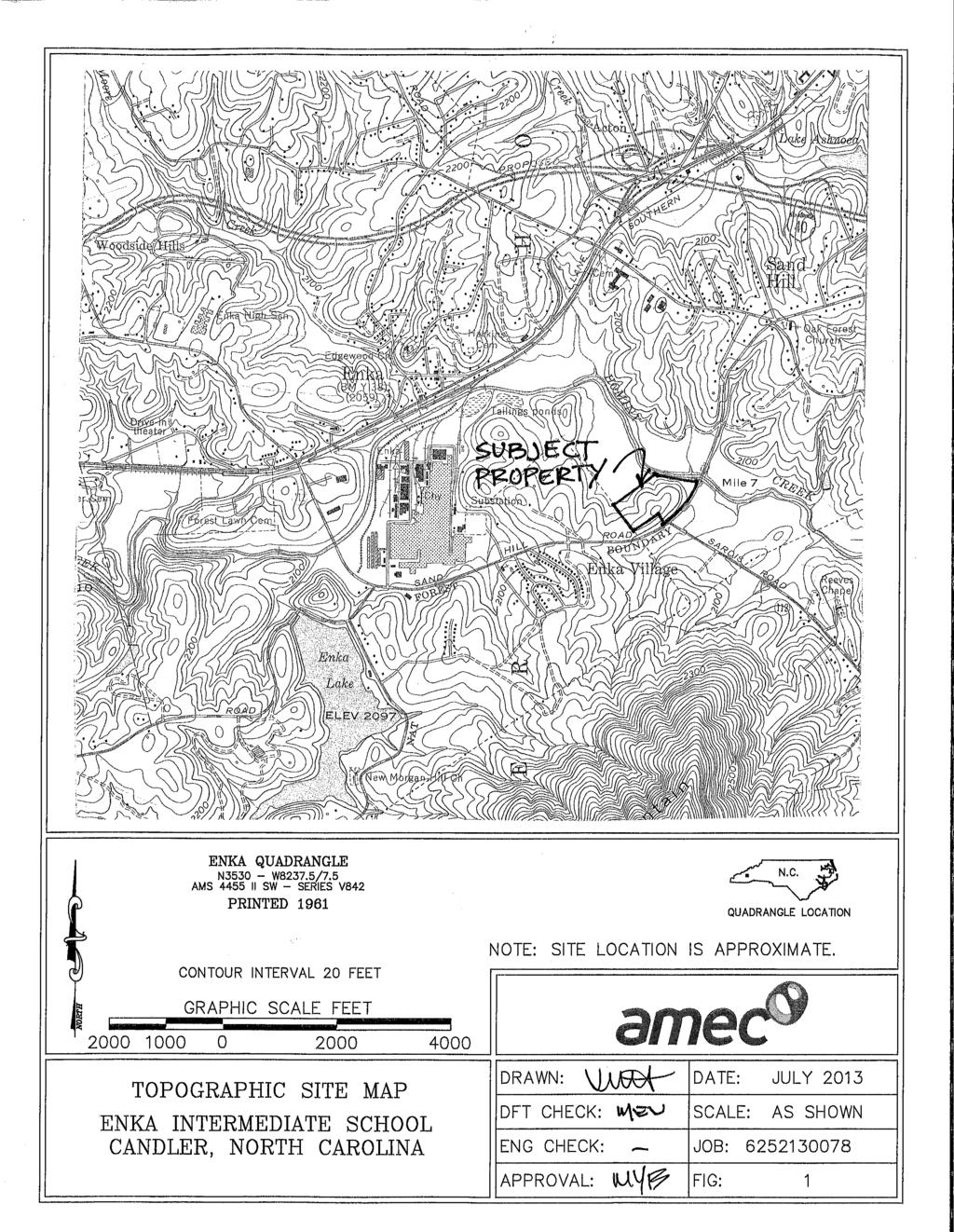
3 Enka Intermediate School Report of Preliminary Geotechnical Exploration July 24, 2013 AMEC Project No TABLE OF CONTENTS 1.0 PROJECT INFORMATION Site Information Project Information Site Geology SUBSURFACE EXPLORATION Preliminary Geotechnical Exploration Environmental Services SUBSURFACE CONDITIONS PRELIMINARY SEISMIC SITE CLASSIFICATION GERAL DISCUSSION OF SITE AND SUBSURFACE CONDITIONS Existing Fill Shallow Rock and Boulders PRELIMINARY FOUNDATION RECOMMENDATIONS GERAL CONSTRUCTION RECOMMENDATIONS Site Preparation and Erosion Protection Excavation Conditions Groundwater Control Surface Water Control and Moisture Sensitive Soils Cut and Fill Slopes Suitability of Site Soils for Use as Structural Fill QUALIFICATIONS... 9 Attachments Figure 1 Topographic Site Location Map Figure 2 Boring Location Plan Key to Symbols and Descriptions Soil Test Boring Records (18) 2
4 Enka Intermediate School Report of Preliminary Geotechnical Exploration July 24, 2013 AMEC Project No PROJECT INFORMATION 1.1 Site Information Project and site information was obtained from site visits and conversations with you. Based on this information, we understand that Buncombe County Schools is considering the site located at the intersection of Sardis Road and Sand Hill Road in Candler, North Carolina (Figure 1) for construction of a new Intermediate School. The property is bound by Asheville Commerce Parkway (partially constructed) and Hominy Creek to the north, Sand Hill Road to the east/southeast, undeveloped commercial land to the south (separating the site from Sardis Road), and overhead power lines and existing industrial facilities to the west. The site is currently vacant and partially overgrown with vegetation. There is evidence of past earthwork activity at the site including areas where soil has been cut (in the east/northeast portions of the site) and areas where fill has been placed (northwest portion of the site and for construction of the roadway along the northern border of the site). Rock outcrops are present at the ground surface within the topographically high area near the center of the south side of the site. A pile of boulders, likely removed during excavation of borrow material from the east/northeastern portion of the site, is also located in the topographically high area of the site. A pile of asphalt and concrete debris is located in the topographically low area of the site (in the northwest portion of the site). Existing sewer and stormwater utility lines were observed to be present on the north boundary of the site, extending east from Asheville Commerce Parkway. Several dirt roadways are present throughout the site. A culvert and fill soil was placed to establish an access road near the northwest corner of the site. The fill over and around this culvert is currently unstable and has slid into the adjacent drainage feature on both sides of the culvert. Evidence of erosion is present throughout the site. Erosion gullies (some more than 4 feet deep) are present along the dirt access road on the west side of the site and along the slope at the western border of the site. 1.2 Project Information The layout of the site and the location of the school building are still being considered at this time. However, we understand that the building will likely be located near the center of the site and that the playing fields will be located on the western portion of the site (near the overhead power lines). The proposed traffic pattern is still being considered at this time; however, we understand that the site will connect with Asheville Commerce Parkway and Sand Hill Road. Buncombe County Schools plans to utilize the prototype building design that was used for their two other recently constructed intermediate schools. This building consists of a two-story structural masonry building supported by shallow foundation and grade-slabs. 1
5 Enka Intermediate School Report of Preliminary Geotechnical Exploration July 24, 2013 AMEC Project No Site Geology The project site is located in the Blue Ridge Physiographic Province. The bedrock in this province is a complex mixture of igneous, sedimentary and metamorphic rock that has been repeatedly squeezed, fractured, faulted and distorted by past tectonic movements. The virgin soils encountered in this area are the residual product of in-place weathering of rock, which was similar to the rock presently underlying the site. In areas not altered by erosion or disturbed by the activities of development, the typical residual soil profile consists of clayey soils near the surface, where soil weathering is more advanced, underlain by sandy silts and silty sands. The less weathered soils exhibit relict features of the parent rock, including foliation patterns and joints. The boundary between soil and rock is not sharply defined. This transitional zone termed "partially weathered rock" (PWR) is normally found overlying the parent bedrock. Partially weathered rock is defined, for engineering purposes, as residual material with standard penetration resistance values in excess of 100 blows per foot. Fractures, joints, and the presence of less resistant rock types facilitate weathering. Consequently, the profile of the partially weathered rock and hard rock is quite irregular and erratic, even over short horizontal distances. Also, it is not unusual to find lenses and boulders of hard rock and zones of partially weathered rock within the soil mantle, well above the general bedrock level. 2.0 SUBSURFACE EXPLORATION 2.1 Preliminary Geotechnical Exploration For this preliminary exploration, AMEC drilled eighteen soil test borings at the approximate locations shown on Figure 2. Eleven soil test borings were drilled in a predetermined grid pattern across the site. Seven additional boring locations were selected in order to explore the area where shallow rock is present. The boring locations were selected and marked in the field by AMEC. The as-drilled locations were later surveyed by McGill Associates, PA and will be shown on the topographical site survey drawing (which was not yet available at the time of this report). An existing topographical survey prepared by Ed Holmes and Associates, PA (and spot checked by McGill) was used during this evaluation of site and subsurface conditions and is shown on the attached Boring Location Plan (Figure 2). The boring locations and ground surface elevations at the boring locations were provided by McGill. The soil test borings were drilled by mechanically twisting hollow-stem augers into the soil. Soil sampling and penetration testing were performed in general accordance with ASTM D1586. At assigned intervals, soil samples were obtained with a standard 1.4-inch I.D., 2-inch O.D. split-spoon sampler. The sampler was first seated 6 inches to penetrate any loose cuttings, and then driven an additional 12 inches with blows of a 140-pound hammer falling 30 inches. The number of hammer blows required to drive the sampler the final 12 inches was recorded and is designated the "N- 2
6 Enka Intermediate School Report of Preliminary Geotechnical Exploration July 24, 2013 AMEC Project No Value" or "penetration resistance". The N-Value, when properly evaluated, is an index to soil strength and foundation supporting capability. Representative portions of split spoon samples were sealed in glass jars and returned to our laboratory where they were visually classified by a geotechnical engineer. Depth to groundwater was measured in borings B-1 through B-11 at the time of drilling and after a period of 24 hours. The boreholes were backfilled with auger cuttings after being sounded for groundwater. Borings B-12 through B-18 were backfilled upon completion; therefore, 24-hour groundwater levels were not measured (the primary intent of these borings was to determine the presence and depth of rock). 2.2 Environmental Services A Phase I Environmental Site Assessment including regulatory file reviews and limited environmental sampling was also conducted. In order to collect groundwater samples for environmental testing, temporary sampling points were installed within five of the boreholes during our preliminary exploration. The temporary sampling points were removed and the boreholes were backfilled with grout after collection of the groundwater samples. The results of our environmental services were presented under separate cover. 3.0 SUBSURFACE CONDITIONS The following descriptions provide a general summary of the subsurface conditions encountered. The Test Boring Records represent our interpretation of the field drilling logs based on engineering examination of the field samples. The lines designating the interfaces between various strata represent approximate boundaries and the transition between strata may be gradual. It should be noted that subsurface conditions will vary between the boring locations. In general, the soil test borings encountered fill, alluvium, residuum, partially weathered rock, and auger refusal material/rock as described below and tabulated in Table 1. Topsoil: Topsoil was not encountered at the ground surface at the test boring locations. Fill / Alluvium: Fill and alluvial soils were encountered in Borings B-1 and B-2 which are located within the access road along the north border of the site. Fill soil was likely placed over alluvial soil to create the existing roadway and during installation of the existing underground utilities. These soils were sampled as firm to stiff sandy and clayey Silt, very loose to very firm silty and clayey Sands, and dense Gravel. The fill / alluvium was encountered to depths of 22 feet in boring B-1 and 16 feet in boring B-2. N-values obtained in the fill and alluvium ranged from 3 to 32 pbf. The higher N-values were likely caused by rock pieces. 3
7 Enka Intermediate School Report of Preliminary Geotechnical Exploration July 24, 2013 AMEC Project No Fill and alluvium where also encountered in boring B-3. Fill sampled as firm to very stiff sandy silt and loose to firm silty sand was encountered to a depth of 27 feet. Alluvial soil sampled as loose sand with plastic silts and clayey plastic silt was encountered from 27 feet deep to the boring termination depth of 35 feet. N-values in this fill ranged from 6 to 19 bpf. Fill: Fill soil was also encountered in boring B-5. Fill sampled as loose silty sand was encountered to a depth of 3 feet and soft sandy silt was sampled from depths of 3 to 8 feet. Topsoil was sampled within the fill in the 6 to 7.5 feet sample; therefore, this area of the site was not likely stripped prior to the placement of fill. Residuum: Residual soil was encountered below the fill and alluvial soils in borings B-1, B-2, and B-5 and at the ground surface in the remainder of the borings. In general, the residual soil was sampled as loose to very dense silty sand and firm to very stiff sandy silt. Partially Weathered Rock and Auger Refusal: Partially weathered rock and auger refusal was encountered at the approximate depths and elevations shown in Table 1, ranging from as shallow as 1 foot (in boring B-12) to as deep as 29 feet (in boring B-1). Groundwater: Borings B-1 through B-11 were sounded for presence of groundwater at the time of boring and after a stabilization period of at least 24 hours and the results were recorded on the Test Boring Records. The stabilized groundwater levels in borings B-1, B-2, B-3, B-6, and B-11 were measured within the temporary sampling points. Borings B-12 through B-18 were backfilled upon completion; therefore, 24-hour groundwater levels were not recorded. A summary of the encountered groundwater levels is included in Table 1. 4
8 Enka Intermediate School Report of Preliminary Geotechnical Exploration July 24, 2013 AMEC Project No Boring No. B-1 B-2 B-3 Fill and Alluvium 0 22 ( ) 0 16 ( ) 0 35 ( ) B-4 B ( ) B-6 B-7 B-8 B-9 B-10 B-11 B-12 B-13 B-14 B-15 Table 1. Summary of Subsurface Conditions Strata Depths and Elevations, feet Residual Soil ( ) ( ) 0 25 ( ) 8 25 ( ) 0 60 ( ) 0 25 ( ) 0 25 ( ) 0 14 ( ) 0 25 ( ) 0 35 ( ) 0 2 ( ) 0-8 ( ) ( ) 0 7 ( ) ( ) ( ) B ( ) B ( ) B ( ) Partially Weathered Rock ( ) ( ) ( ) ( ) 8 12 ( ) 7 12 ( ) ( ) ( ) ( ) Boring Termination or Auger Refusal ) ) ) ) ) ) ) ) ) ) 2.5 (AR@2099.5) ) ) ) ) ) ) PWR Partially Weathered Rock BT Boring Termination without auger refusal. AR Auger Refusal Groundwater level readings were taken at least 24 hrs after drilling unless otherwise noted. TOB Time of Boring Not Encountered Groundwater 15.8 (2046.8) 8.5 (2038.8) 17.7 (2061.1) TOB (2075@TOB) 41.1 (2067.4) 9 (2085) 9 (2089) 28.6 (2086.2) TOB (2079.5@TOB) 18.2 (2081.4) 5
9 Enka Intermediate School Report of Preliminary Geotechnical Exploration July 24, 2013 AMEC Project No PRELIMINARY SEISMIC SITE CLASSIFICATION Seismic site class is calculated based on correlation of the average N-value with soil shear wave velocity for the top 100 feet below the proposed building elevations in accordance with Section 16 of the North Carolina Building Code. Our experience in the site area has shown that it is reasonable to assume that material with standard penetration resistances (N-values) equal to or greater than 100 blows per foot will exist below auger refusal, where auger refusal is encountered below a layer of increasing harder residual soil. Because the location and finish floor elevation of the new Intermediate School building has not been selected at this time, a seismic site class cannot be assigned. However, if the building is located near the center of the site, where minimal fill/alluvial soil was encountered, a Seismic Site Class of C or D will be available. For preliminary design purposes, a Seismic Site Class of D may be assigned. Subsurface conditions similar to those encountered in boring B-3 will warrant additional exploration and consideration prior to assigning a Seismic Site Class. 5.0 GERAL DISCUSSION OF SITE AND SUBSURFACE CONDITIONS In general, the site and subsurface conditions are favorable for construction of a new Intermediate School. Two items identified during this exploration that could affect the ease and cost of construction are the existing fill and the shallow rock and boulders. 5.1 Existing Fill Remedial site repair may be necessary in areas where non-engineered fill and alluvium is present. The existing fill present along the roadway at the northern border of the site (as sampled in borings B-1 and B-2) will need to be reworked in order to provide positive support for asphalt-paved roadways and parking areas. The subsurface conditions along the roadway will likely vary and the amount of reworking necessary will depend on the time of year and amount of construction traffic in this area. Recommendations for reworking the subgrade should be provided during construction based on the actual site conditions but may include recommendations to remove and recompact two to three feet of soil below the proposed roadway subgrade elevation or placement of geogrid reinforcement. The fill soil in this area of the site includes sandy and clayey silts which are highly sensitive to moisture and may be difficult to work with during rainy times of the year. The existing fill encountered in boring B-3 is suitable for positive support of the proposed ballfields. However, approximately 5.5 feet of sandy silt was encountered at the ground surface. In general, silty soils are generally not free draining and therefore ponding of rainwater and surface water may occur if the ground surface is not sloped to promote drainage. 6
10 Enka Intermediate School Report of Preliminary Geotechnical Exploration July 24, 2013 AMEC Project No Shallow Rock and Boulders The cluster of borings located near the center of the site show that the location and depth of rock varies greatly within short horizontal distances. The rock present at the ground surface is thought to be boulders within the soil matrix and not continuous bedrock. A pile of boulder is also present in this area of the site. It is likely that these boulders were removed from the soil during previous excavation of borrow from the site and placed in the area where excavation was determined to be the most difficult due to the presence of rock/boulders. During mass grading activities, boulders present within the soil matrix may be able to be removed with large excavation equipment with ripping tools and/or pneumatic hammers. However, continuous bedrock and large boulders present above the proposed site elevations and within trenches for underground utilities and building foundation excavations will likely require blasting for removal. 6.0 PRELIMINARY FOUNDATION RECOMMENDATIONS Based on the existing topography of the site, we anticipate that both cut and fill will be required to establish a level site for construction of the proposed Intermediate School building. Based on the available boring data and our experience with similar soil conditions, the subsurface conditions are favorable for support of placement of compacted structural fill and/or shallow foundation support of the proposed Intermediate School building (up to two stories tall). The residual soils present in the center and eastern portions of the site are suitable for support of maximum allowable bearing pressures in the range of 3,000 to 5,000 psf. Foundations bearing in structural fill (compacted to at least 95 percent of the standard Proctor maximum dry density) or a combination of residual soil and compacted fill may be designed for an allowable bearing pressure of 3,000 psf. A final design foundation bearing pressure can be provided after site layout plans and elevations have been selected and the subsurface conditions confirmed by additional exploration within the selected construction areas, if required. If the proposed building is located in the area of boring B-5, some reworking of the existing fill will be required prior to placement of structural fill or construction of shallow foundations. Depending on final site grades, this could involve complete removal and replacement of this fill. Recommendations for construction of shallow foundations can be provided during the design phase of this project. 7
11 Enka Intermediate School Report of Preliminary Geotechnical Exploration July 24, 2013 AMEC Project No GERAL CONSTRUCTION RECOMMENDATIONS 7.1 Site Preparation and Erosion Protection In general, vegetation and surface soils containing organic matter or other deleterious materials should be stripped and removed from the proposed construction limits. The asphalt and concrete debris located in the northwest portion of the site should be removed from the construction area. At this time, evidence of on-going erosion, such as deep erosion gullies and washed-out fill slopes, is present at the site. Assuming that construction of the proposed Intermediate School building and campus will not begin immediately; we recommend that erosion control measures be installed at the site in order to avoid degradation of otherwise suitable site subgrade. Erosion control measures should include stabilizing currently unstable areas of the site (around the culvert on the north side of the site), filling existing erosion control gullies, and establishing ground cover/grass. 7.2 Excavation Conditions As discussed in Section 5.2, boulders present within the soil matrix may be able to be removed with large excavation equipment with ripping tools and/or pneumatic hammers. However, continuous bedrock and large boulders present above the proposed site elevations and within trenches for underground utilities and building foundation excavations will likely require blasting for removal. In general, partially weathered rock with N-values ranging from 50 blows per 6 inches to 50 blows per 3 inches can often be excavated with bulldozers or powerful tractor-drawn rippers without blasting, although often with difficulty. Much can depend on the quality of the equipment and the experience of the operators, as well as the nature of the material being excavated (i.e., presence and direction of more weathered seams, bedding planes, etc.). Partially weathered rock harder than 50 blows per 2 inches generally requires blasting for efficient excavation. Excavation below refusal depths in the borings will require blasting for removal of the refusal materials. 7.3 Groundwater Control Groundwater was encountered at depths as shallow as 8.5 feet below the existing ground surface elevations. The encountered groundwater levels (summarized in Table 1) should be compared to the proposed site grades (when available) to determine the extent of groundwater control that will be required during construction. 7.4 Surface Water Control and Moisture Sensitive Soils Sandy and clayey silts were encountered near the existing ground surface in our soil test borings. This type of soil is sensitive to moisture changes and will require additional time to dry and rework if the moisture content is much above optimum. In order to avoid degradation of otherwise suitable 8
12 Enka Intermediate School Report of Preliminary Geotechnical Exploration July 24, 2013 AMEC Project No soil subgrade, it will be important to maintain control of surface water at the site. This has been accomplished on past projects by sloping the ground surface to promote drainage and rolling the ground surface at the end of each day with a smooth drum roller. 7.5 Cut and Fill Slopes Cut slopes may be constructed as steep as 2:1 (horizontal:vertical). Fill slopes should be constructed on a suitable firm foundation. Where normal slope maintenance is desired, we recommend fill slopes be constructed at 2.5:1 (horizontal:vertical), or flatter. It has been our experience with soils similar to those encountered at the site, that permanent slopes constructed steeper than 2:1 (horizontal:vertical), may exhibit surficial erosion and/or sloughing during periods of heavy rain or prolonged rainfall. All slopes should be seeded and mulched as soon as practical to prevent surface erosion. Permanent slopes constructed at 3:1 (horizontal:vertical) or flatter would be desirable for mowing. 7.6 Suitability of Site Soils for Use as Structural Fill Based on our experience with soil similar to that encountered at the site, the on-site soil should be suitable for use as compacted structural fill. In general, soils containing more than 5 percent (by weight) fibrous organic materials or having a Plasticity Index (PI) greater than 30 (less than 20 is recommended for soils within 5 feet of the finished floor elevation) should not be used for fill. The sandy and clayey silts present at the site are sensitive to moisture changes and will require additional time to dry and rework if the moisture content is much above optimum. Partially weathered rock material may be used for structural fill provided it can be broken down by the excavation and compaction equipment into particles with maximum dimensions of 6 inches. 8.0 QUALIFICATION OF REPORT This geotechnical exploration was preliminary in nature and does not attempt to represent the subsurface conditions between the boring locations. The recommendations provided in this preliminary report should be confirmed or amended as appropriate during the final design phase of this project. The assessment of site environmental conditions for the presence of pollutants in the soil, rock, or ground water of the site is beyond the scope of this exploration. 9
13 ATTACHMENTS
14
15
16
17
18
19
20
21
22
23
24
25
26
27
28
29
30
31
32
33
34
35
Preliminary Geotechnical Engineering Report
 Preliminary Geotechnical Engineering Report Park 3 Barrow County, Georgia July, Terracon Project No. 4906 Prepared For: Winder Barrow Industrial Authority Prepared By: Terracon Consultants, Inc. Atlanta,
REPORT OF PRELIMINARY GEOTECHNICAL SITE INVESTIGATION KERSHAW COUNTY EXIT 87 OFFICE PARK. ELGIN, SOUTH CAROLINA S&ME Project No.
 REPORT OF PRELIMINARY GEOTECHNICAL SITE INVESTIGATION KERSHAW COUNTY EXIT 87 OFFICE PARK ELGIN, SOUTH CAROLINA S&ME Project No. 1611-04-450 Prepared For: KERSHAW COUNTY ECONOMIC DEVELOPMENT OFFICE Post
ATTACHMENT A PRELIMINARY GEOTECHNICAL SUMMARY
 ATTACHMENT A PRELIMINARY GEOTECHNICAL SUMMARY Kevin M. Martin, P.E. KMM Geotechnical Consultants, LLC 7 Marshall Road Hampstead, NH 0384 603-489-6 (p)/ 603-489-8 (f)/78-78-4084(m) kevinmartinpe@aol.com
Northern Colorado Geotech
 PRELIMINARY GEOTECHNICAL ENGINEERING REPORT PROPOSED CECIL FARMS DEVELOPMENT WELD COUNTY ROAD 7, BETWEEN ROADS 7 AND 7 SEVERANCE, COLORADO NORTHERN COLORADO GEOTECH PROJECT NO. 0-6 APRIL 0, 06 Prepared
Geotechnical Data Report
 Geotechnical Data Report Downtown Greenville Future Conveyance Study December 1, 2015 Terracon Project No. 86155032 Prepared for: Prepared by: Terracon Consultants, Inc. December 1, 2015 561 Mauldin Road
Converse Consultants Geotechnical Engineering, Environmental & Groundwater Science, Inspection & Testing Services
 Converse Consultants Geotechnical Engineering, Environmental & Groundwater Science, Inspection & Testing Services Ms. Rebecca Mitchell Mt. San Antonio College Facilities Planning & Management 1100 North
Limited Geotechnical Engineering Evaluation Classroom Additions Albany County Campus Laramie, Wyoming
 Limited Geotechnical Engineering Evaluation Classroom Additions Albany County Campus 2300 Missile Drive, Cheyenne, Wyoming 82001 Phone 307-635-0222 www.stratageotech.com Limited Geotechnical Engineering
B-1 BORE LOCATION PLAN. EXHIBIT Drawn By: 115G BROOKS VETERINARY CLINIC CITY BASE LANDING AND GOLIAD ROAD SAN ANTONIO, TEXAS.
 N B-1 SYMBOLS: Exploratory Boring Location Project Mngr: BORE LOCATION PLAN Project No. GK EXHIBIT Drawn By: 115G1063.02 GK Scale: Checked By: 1045 Central Parkway North, Suite 103 San Antonio, Texas 78232
PREPARED FOR MR. JOE WOOD CARTER & SLOOPE, INC PEAKE ROAD MACON, GEORGIA PREPARED BY
 SUBSURFACE EXPLORATION AND GEOTECHNICAL ENGINEERING EVALUATION MACON WATER AUTHORITY (MWA) SANITARY SEWER RELOCATION MACON, GEORGIA GEC PROJECT NO. 14077.2 PREPARED FOR MR. JOE WOOD CARTER & SLOOPE, INC.
June 9, R. D. Cook, P.Eng. Soils Engineer Special Services Western Region PUBLIC WORKS CANADA WESTERN REGION REPORT ON
 PUBLIC WORKS CANADA WESTERN REGION REPORT ON GEOTECHNICAL INVESTIGATION PROPOSED MARTIN RIVER BRIDGE MILE 306.7 MACKENZIE HIGHWAY Submitted by : R. D. Cook, P.Eng. Soils Engineer Special Services Western
Civil Engineering, Surveying and Environmental Consulting WASP0059.ltr.JLS.Mich Ave Bridge Geotech.docx
 2365 Haggerty Road South * Canton, Michigan 48188 P: 734-397-3100 * F: 734-397-3131 * www.manniksmithgroup.com August 29, 2012 Mr. Richard Kent Washtenaw County Parks and Recreation Commission 2330 Platt
Geotechnical Subsurface Exploration, Engineering Evaluation and Dam Visual Observation Sun Valley Drive Extension Roswell, Fulton County, GA
 Ranger Consulting, Inc. Geotechnical, Environmental, Drilling, Construction 3147 Martha Berry Highway, Rome, Georgia 165; Phone: 76-29-1782; Fax: 76-29-171 April 2, 215 Mr. Tommy Crochet, PE McGee Partners,
Pierce County Department of Planning and Land Services Development Engineering Section
 Page 1 of 7 Pierce County Department of Planning and Land Services Development Engineering Section PROJECT NAME: DATE: APPLICATION NO.: PCDE NO.: LANDSLIDE HAZARD AREA (LHA) GEOLOGICAL ASSESSMENT REPORT
REPORT NO 12/115/D NOVEMBER 2012 GEOTECHNICAL INVESTIGATION FOR THE PROPOSED SOLAR PHOTOVOLTAIC FACILITY, GROOTVLEI POWER STATION
 Consulting Geotechnical Engineers & Engineering Geologists P.O.Box 3557 Cramerview 2060. Tel: (011) 465-1699. Fax: (011) 465-4586. Cell 082 556 7302 & 076 966 8445 REPORT NO 12/115/D NOVEMBER 2012 GEOTECHNICAL
Geotechnical Engineering Report
 Geotechnical Engineering Report Richland Creek Trunk Sewer Greenville, South Carolina March 31, 2014 Terracon Project No. 86145008 Prepared for: Renewable Water Resources Greenville, South Carolina Prepared
Geotechnical Investigation Juneau Seawalk - Taku Fisheries to Miner s Wharf Juneau, Alaska DM&A Job No
 Duane Miller & Associates 5821 Arctic Boulevard, Suite A Anchorage, AK 99518-1654 (907) 644-3200 Fax 644-0507 Arctic & Geotechnical Engineering May 4, 2006 Tetra Tech/KCM, Inc. 1971 First Avenue Seattle,
Preliminary Geotechnical Evaluation Gooseberry Point Pedestrian Improvements Whatcom County, Washington SITE AND PROJECT DESCRIPTION
 File No. 12-100 Geotechnical & Earthquake Engineering Consultants Mr. Kevin Brown, P.E. Gray & Osborne, Inc. 3710 168 th Street NE, Suite B210 Arlington, Washington 98223 Subject: Draft Report Preliminary
Report of Subsurface Exploration and Geotechnical Engineering Evaluation
 Report of Subsurface Exploration and Geotechnical Engineering Evaluation Proposed Chatham County Jail Pittsboro, North Carolina F&R Project No. 66N-0097 Prepared For: CHATHAM COUNTY P.O. Box 1809 Pittsboro,
3.12 Geology and Topography Affected Environment
 3 Affected Environment and Environmental Consequences 3.12 Geology and Topography 3.12.1 Affected Environment 3.12.1.1 Earthquakes Sterling Highway MP 45 60 Project Draft SEIS The Kenai Peninsula is predisposed
 R-1 Conveyor Relocation Project Legend 0 500 1000 1500 ft. This map is a user generated static output from an Internet mapping site and is for general reference only. Data layers that appear on this map
REPORT OF SUBSURFACE EXPLORATION
 REPORT OF SUBSURFACE EXPLORATION GRAND RIVER DAM AUTHORITY HULBERT 69 KV SWITCHING STATION S. 440 Road Hulbert, Cherokee County, Oklahoma ENERCON PROJECT NO. GRDA006 MARCH 7, 2012 PREPARED FOR: C/O ENERCON
Geotechnical Engineering Study, Conifer Senior High School Football Field Improvements, Conifer, Colorado
 2390 South Lipan Street Denver, CO 80223 phone: (303) 742-9700 fax: (303) 742-9666 email: kadenver@kumarusa.com www.kumarusa.com Office Locations: Denver (HQ), Colorado Springs, Fort Collins, and Frisco,
ENCE 3610 Soil Mechanics. Site Exploration and Characterisation Field Exploration Methods
 ENCE 3610 Soil Mechanics Site Exploration and Characterisation Field Exploration Methods Geotechnical Involvement in Project Phases Planning Design Alternatives Preparation of Detailed Plans Final Design
Geotechnical Engineering Report
 Geotechnical Engineering Report Turner Turnpike Widening Polecat Creek Bridge (Bridge A) June 1, 2016 Terracon Project No. 04155197 Prepared for: Garver, LLC Prepared by: Terracon Consultants, Inc. TABLE
APPENDIX E SOILS TEST REPORTS
 Otsego County, NY Site Work Specifications APPENDIX E SOILS TEST REPORTS Blue Wing Services, Inc. July 1, 2010 Blue Wing Services May 20, 2010 Page 2 the site, was not made available to Empire at this
Preliminary Geotechnical Investigation Cadiz / Trigg County I-24 Business Park. Cadiz, Kentucky
 Environmental & Geoscience, LLC 834 Madisonville Road Hopkinsville, KY 440 70.44.000 FAX 70.44.8300 www.wedrill.com A member of Trinity Energy & Infrastructure Group, LLC Preliminary Geotechnical Investigation
GEOTECHNICAL ENGINEERING REPORT
 GEOTECHNICAL ENGINEERING REPORT Route 0 (Patrick Henry Highway) Bridge and Approaches over Louse Creek Charlotte County, Virginia UPC 907, VDOT Project: 000-019-807 Schnabel Reference P1079 / 110, On-Call
 Photo 1 - Southerly view across 2700 parking lot toward existing building. Multi-residential building borders western side of property in upper right of view. Photo 2 - Southerly view across 2750 parking
SITE INVESTIGATION 1
 SITE INVESTIGATION 1 Definition The process of determining the layers of natural soil deposits that will underlie a proposed structure and their physical properties is generally referred to as site investigation.
M E M O R A N D U M. Mr. Jonathan K. Thrasher, P.E., Mr. Ian Kinnear, P.E. (FL) PSI
 PSI") M E M O R A N D U M TO: FROM: Mr. Mark Schilling Gulf Interstate Engineering Mr. Jonathan K. Thrasher, P.E., Mr. Ian Kinnear, P.E. (FL) PSI DATE: November 11, 2014 RE: Summary of Findings Geotechnical
M E M O R A N D U M TO: FROM: Mr. Mark Schilling Gulf Interstate Engineering Mr. Jonathan K. Thrasher, P.E., Mr. Ian Kinnear, P.E. (FL) PSI DATE: November 11, 2014 RE: Summary of Findings Geotechnical
Gotechnical Investigations and Sampling
 Gotechnical Investigations and Sampling Amit Prashant Indian Institute of Technology Gandhinagar Short Course on Geotechnical Investigations for Structural Engineering 12 14 October, 2017 1 Purpose of
Report of Preliminary Geotechnical Exploration. CSO-012 Sewer Separation Cincinnati, Hamilton County, Ohio. February, 2011
 11242843_GeoTech_Preliminary - Feburary 2011_1/40 Report of Preliminary Geotechnical Exploration CSO-012 Sewer Separation Cincinnati, Hamilton County, Ohio February, 2011 11242843_GeoTech_Preliminary -
Materials. Use materials meeting the following.
 208.01 Section 208. SOIL EROSION AND SEDIMENTATION CONTROL 208.01 Description. Install and maintain erosion and sedimentation controls to minimize soil erosion and to control sedimentation from affecting
CITY OF CAPE CORAL NORTH 2 UTILITIES EXTENSION PROJECT CONTRACT 3
 GEOTECHNICAL REPORT CITY OF CAPE CORAL NORTH UTILITIES EXTENSION PROJECT CONTRACT City of Cape Coral Procurement Division Cultural Park Boulevard, nd Floor Cape Coral, FL ISSUED FOR BID VOLUME of GEOTECHNICAL
3.0 SUMMARY OF FINDINGS
 AECOM 500 W Jefferson St. Suite 1600 Louisville, KY 40202 www.aecom.com 502-569-2301 tel 502-569-2304 fax October 17, 2018 Big Rivers Electric Corporation Sebree Generating Station 9000 Highway 2096 Robards,
Impact : Changes to Existing Topography (Less than Significant)
") 4.2 Land Resources 4.2.1 Alternative A Proposed Action Impact 4.2.1-1: Changes to Existing Topography (Less than Significant) Development of the project site would involve grading and other earthwork as
4.2 Land Resources 4.2.1 Alternative A Proposed Action Impact 4.2.1-1: Changes to Existing Topography (Less than Significant) Development of the project site would involve grading and other earthwork as
Depth (ft) USCS Soil Description TOPSOIL & FOREST DUFF
 USCS Soil Description TOPSOIL & FOREST DUFF") Test Pit No. TP-6 Location: Latitude 47.543003, Longitude -121.980441 Approximate Ground Surface Elevation: 1,132 feet Depth (ft) USCS Soil Description 0 1.5 1.5 5.0 SM 5.0 8.0 SM Loose to medium dense,
Test Pit No. TP-6 Location: Latitude 47.543003, Longitude -121.980441 Approximate Ground Surface Elevation: 1,132 feet Depth (ft) USCS Soil Description 0 1.5 1.5 5.0 SM 5.0 8.0 SM Loose to medium dense,
Geotechnical Engineering Report
 Geotechnical Engineering Report Turner Turnpike Widening Bridge D Bridge Crossing: South 209 th West Avenue Creek County, Oklahoma June 1, 2016 Terracon Project No. 04155197 Prepared for: Garver, LLC Tulsa,
HISTORY OF CONSTRUCTION FOR EXISTING CCR SURFACE IMPOUNDMENT PLANT GASTON ASH POND 40 CFR (c)(1)(i) (xii)
(1)(i) (xii)") HISTORY OF CONSTRUCTION FOR EXISTING CCR SURFACE IMPOUNDMENT PLANT GASTON ASH POND 40 CFR 257.73(c)(1)(i) (xii) (i) Site Name and Ownership Information: Site Name: E.C. Gaston Steam Plant Site Location:
HISTORY OF CONSTRUCTION FOR EXISTING CCR SURFACE IMPOUNDMENT PLANT GASTON ASH POND 40 CFR 257.73(c)(1)(i) (xii) (i) Site Name and Ownership Information: Site Name: E.C. Gaston Steam Plant Site Location:
DATA REPORT GEOTECHNICAL INVESTIGATION GALVESTON CRUISE TERMINAL 2 GALVESTON, TEXAS
 DATA REPORT GEOTECHNICAL INVESTIGATION GALVESTON CRUISE TERMINAL 2 GALVESTON, TEXAS SUBMITTED TO PORT OF GALVESTON 123 ROSENBERG AVENUE, 8TH FLOOR GALVESTON, TEXAS 77553 BY HVJ ASSOCIATES, INC. HOUSTON,
PRELIMINARY GEOTECHNICAL ENGINEERING REPORT
 PRELIMINARY GEOTECHNICAL ENGINEERING REPORT TOWN OF ASHLAND TOWN HALL 101 THOMPSON STREET ASHLAND, VIRGINIA JOB NUMBER: 39016 PREPARED FOR: PMA PLANNERS & ARCHITECTS 10325 WARWICK BOULEVARD NEWPORT NEWS,
PRELIMINARY GEOTECHNICAL ENGINEERING REPORT. Proposed Re-Development 44 Old Worcester Road Charlton, Massachusetts. Prepared For:
 PRELIMINARY GEOTECHNICAL ENGINEERING REPORT Proposed Re-Development 44 Old Worcester Road Charlton, Massachusetts Prepared For: Meridian Associates, Inc. 500 Cummings Center, Suite 5950 Beverly, Massachusetts
GEOTECHNICAL REPORT CBSA Facility Redevelopment Thousand Islands International Crossing Lansdowne, Ontario
 GEOTECHNICAL REPORT CBSA Facility Redevelopment Thousand Islands International Crossing Lansdowne, Ontario Prepared For: The Federal Bridge Corporation Limited SPL Project No.: 10001084 Report Date: January
Geotechnical Engineering Report
 Geotechnical Engineering Report Turner Turnpike Widening Bridge B Bridge Crossing: South 257 th West Avenue Creek County, Oklahoma June 1, 2016 Terracon Project No. 04155197 Prepared for: Garver, LLC Tulsa,
Boreholes. Implementation. Boring. Boreholes may be excavated by one of these methods: 1. Auger Boring 2. Wash Boring 3.
 Implementation Boreholes 1. Auger Boring 2. Wash Boring 3. Rotary Drilling Boring Boreholes may be excavated by one of these methods: 4. Percussion Drilling The right choice of method depends on: Ground
IV. ENVIRONMENTAL IMPACT ANALYSIS G. GEOLOGY AND SOILS
 IV. ENVIRONMENTAL IMPACT ANALYSIS G. GEOLOGY AND SOILS The following section is a summary of the geotechnical report conducted for the proposed project. The Report of Geotechnical Investigation Proposed
ROCK EXCAVATION (GRADING) OPSS 206 INDEX
 OPSS 206 INDEX") 206-2 - OPSS 206 INDEX 206-2.1 GENERAL 206-2.1.1 Classification of Rock Materials 206-2.1.2 Tender Items 206-2.1.3 Other Excavation Tender Items 206-2.1.4 Specifications 206-2.1.5 Special Provisions 206-2.1.6
206-2 - OPSS 206 INDEX 206-2.1 GENERAL 206-2.1.1 Classification of Rock Materials 206-2.1.2 Tender Items 206-2.1.3 Other Excavation Tender Items 206-2.1.4 Specifications 206-2.1.5 Special Provisions 206-2.1.6
 Project: ITHACA-TOMPKINS REGIONAL AIRPORT EXPANSION Project Location: ITHACA, NY Project Number: 218-34 Key to Soil Symbols and Terms TERMS DESCRIBING CONSISTENCY OR CONDITION COARSE-GRAINED SOILS (major
PRELIMINARY GEOTECHNICAL REPORT. State College Redevelopment State College Borough, Centre County, Pennsylvania. CMT Laboratories File No.
 PRELIMINARY GEOTECHNICAL REPORT State College Redevelopment State College Borough, Centre County, Pennsylvania CMT Laboratories File No. 1638700 Prepared for: National Development Council One Battery Park
Reference No S072 APRIL 2012
 A REPORT TO SOLMAR DEVELOPMENT CORP. A PRELIMINARY SOIL INVESTIGATION FOR PROPOSED SUBDIVISION DEVELOPMENT NORTHEAST OF SIDEROAD 5 AND 0 LINE TOWN OF ERIN Reference No. 202-S072 APRIL 202 DISTRIBUTION
Chapter 12 Subsurface Exploration
 Page 12 1 Chapter 12 Subsurface Exploration 1. The process of identifying the layers of deposits that underlie a proposed structure and their physical characteristics is generally referred to as (a) subsurface
14 Geotechnical Hazards
 Volume 2: Assessment of Environmental Effects 296 14 Geotechnical Hazards Overview This Chapter provides an assessment of the underlying geotechnical conditions to identify: any potential liquefaction
February 22, 2016 AG File No
 Ainley Graham & Associates Limited 1-50 Grant Timmins Drive, Kingston, Ontario, K7M 8N2 Tel: (343) 266-0002 Fax: (343) 266-0028 E-mail Kingston@ainleygroup.com February 22, 2016 AG File No. 15062-1 Ministry
GEOTECHNICAL REPORT. Matanuska-Susitna Borough. Parks Highway Connections Museum Drive. Matanuska-Susitna Borough, Alaska.
 Matanuska-Susitna Borough GEOTECHNICAL REPORT Parks Highway Connections Museum Drive Matanuska-Susitna Borough, Alaska March 2, 20 Prepared By: John Thornley, PE Geotechnical Engineer 333 Arctic Blvd.,
Geotechnical Data Report
 Geotechnical Data Report ReWa Solar Farm at Durbin Creek Fountain Inn, South Carolina September 1, 2017 Terracon Project No. 86165043 Prepared for: Renewable Water Resources Greenville, South Carolina
Construction Exits Rock pads
 Construction Exits Rock pads SEDIMENT CONTROL TECHNIQUE Type 1 System Sheet Flow Sandy Soils Type 2 System Concentrated Flow [1] Clayey Soils Type 3 System Supplementary Trap Dispersive Soils [1] Minor
General. DATE December 10, 2013 PROJECT No TO Mary Jarvis Urbandale/Riverside South Development Corporation
 DATE December 10, 201 PROJECT No. 10-1121-0260- TO Mary Jarvis Urbandale/Riverside South Development Corporation CC Justin Robitaille, Urbandale Jonathan Párraga, J.L. Richards & Associates Limited FROM
Geotechnical Investigation
 2015 Cal Poly Pomona, Portland State University, and others. See full permissions statement at end of document. Civil Engineering Writing Project - Genre Unit 3 Geotechnical Site Investigation Report What
3.18 GEOLOGY AND SOILS
 3.18 GEOLOGY AND SOILS This section discusses geologic resource concerns as they relate to the environment, public safety, and project design both during construction and after completion of the project.
APPENDIX C HYDROGEOLOGIC INVESTIGATION
 Figure B-5.7 Figure B-5.8 Preliminary Geotechnical and Environmental Report Appendix C Hydrogeologic Investigation APPENDIX C HYDROGEOLOGIC INVESTIGATION December 21, 2011 WESTSIDE SUBWAY EXTENSION PROJECT
KDOT Geotechnical Manual Edition. Table of Contents
 KDOT Geotechnical Manual 2007 Edition The KDOT Geotechnical Manual is available two volumes. Both volumes are very large electronic (pdf) files which may take several minutes to download. The table of
Background. Valley fills Sites in the Area. Construction over Mine Spoil Fills
 Construction over Mine Spoil Fills Wayne A. Karem, PhD, PE, PG, D.GE 2014 KSPE Annual Conference Background Strip mining; mountaintop and contour mining Creates huge quantities of mine spoil The mine spoil
 SOIL CLASSIFICATION CHART COARSE-GRAINED SOILS MORE THAN 50% RETAINED ON NO.200 SIEVE FINE-GRAINED SOILS 50% OR MORE PASSES THE NO.200 SIEVE PRIMARY DIVISIONS GRAVELS MORE THAN 50% OF COARSE FRACTION RETAINED
16 January 2018 Job Number: RICHARD NEWMAN C\- CLARK FORTUNE MCDONALD AND ASSOCIATES PO BOX 553 QUEENSTOWN
 16 January 2018 Job Number: 50595 RICHARD NEWMAN C\- CLARK FORTUNE MCDONALD AND ASSOCIATES PO BOX 553 QUEENSTOWN CHANSEN@CFMA.CO.NZ STORMWATER DISPOSAL ASSESSMENT Dear Richard, RDAgritech were requested
CHEROKEE NATION BUSINESSES, LLC
 REPORT OF PRELIMINARY SUBSURFACE EXPLORATION AND GEOTECHNICAL EVALUATION PROPOSED CHEROKEE SPRINGS PLAZA TAHLEQUAH, OKLAHOMA BUILDING & EARTH PROJECT NO. OK10004 PREPARED FOR: CHEROKEE NATION BUSINESSES,
Ardaman & Associates, Inc. Geotechnical, Environmental and Materials Consultants
 SUBSURFACE SOIL EXPLORATION 42-INCH FORCE MAIN REPLACEMENT CHIQUITA BOULEVARD S AND SW 34 TH STREET CAPE CORAL, LEE COUNTY, FLORIDA Ardaman & Associates, Inc. Geotechnical, Environmental and Materials
REPORT OF PRELIMINARY GEOTECHNICAL EXPLORATION. Marion County Industrial Park Lot 4. Marion County, South Carolina S&ME Project No.
 REPORT OF PRELIMINARY GEOTECHNICAL EXPLORATION Marion County Industrial Park Lot 4 Marion County, South Carolina S&ME Project No. 1633-12-332 Prepared By: 133 Highway 1 Business Conway, South Carolina
Date: April 2, 2014 Project No.: Prepared For: Mr. Adam Kates CLASSIC COMMUNITIES 1068 E. Meadow Circle Palo Alto, California 94303
 City of Newark - 36120 Ruschin Drive Project Draft Initial Study/Mitigated Negative Declaration Appendix C: Geologic Information FirstCarbon Solutions H:\Client (PN-JN)\4554\45540001\ISMND\45540001 36120
DRILLED DISPLACMENT PILE PERFORMANCE IN COASTAL PLAIN AND RESIDUAL SOILS
 DRILLED DISPLACMENT PILE PERFORMANCE IN COASTAL PLAIN AND RESIDUAL SOILS Presented by: W. Morgan NeSmith, P.E. Berkel & Company Contractors Inc. 770.941.5100 mnesmith@berkelapg.com SC Engineering Conference
 PRELIMINARY GEOTECHNICAL EXPLORATION Additional MeadWestvaco Ridgeville Property 331 acres Dorchester County, South Carolina S&ME Project No. 1131-09-259A Prepared For: BP Barber & Associates Post Office
Town of Amenia Dutchess County New York
 Appendix 9.14.2 Preliminary Geotechnical Investigation 2/2007 Preliminary Geotechnical Interpretive Report for Silo Ridge Golf Resort Community Town of Amenia Dutchess County New York February 16, 2007
Converse Consultants Geotechnical Engineering, Environmental & Groundwater Science, Inspection & Testing Services
 Converse Consultants Geotechnical Engineering, Environmental & Groundwater Science, Inspection & Testing Services July 27, 2017 Ms. Rebecca Mitchell Mt. San Antonio College Facilities Planning & Management
IN SITU SPECIFIC GRAVITY VS GRAIN SIZE: A BETTER METHOD TO ESTIMATE NEW WORK DREDGING PRODUCTION
 IN SITU SPECIFIC GRAVITY VS GRAIN SIZE: A BETTER METHOD TO ESTIMATE NEW WORK DREDGING PRODUCTION Nancy Case O Bourke, PE 1, Gregory L. Hartman, PE 2 and Paul Fuglevand, PE 3 ABSTRACT In-situ specific gravity
INVITATION TO BID CITY OF CAPE CORAL SW 6&7 UTILITIES EXTENSION PROJECT CONTRACT VII CENTRAL AREA 6 AND CENTRAL AREA 8 ITB UT13-02/TM-G
 GEOTECHNICAL REPORT INVITATION TO BID CITY OF CAPE CORAL SW 6&7 UTILITIES EXTENSION PROJECT CONTRACT VII CENTRAL AREA 6 AND CENTRAL AREA 8 ITB UT13-02/TM-G City of Cape Coral Procurement Division 1015
Appendix 11-B Preliminary Geotechnical Investigation
 Appendix 11-B Preliminary Geotechnical Investigation 11.0 Soil, Geology, and Seismology PRELIMINARY SUBSURFACE EXPLORATION AND CONCEPTUAL FOUNDATION ENGINEERING REPORT CPV VALLEY ENERGY CENTER Wawayanda,
ALBEMARLE COUNTY OFFICE OF FACILITIES DEVELOPMENT Hydraulic Road and Barracks Road Sidewalks Improvement Project IFB# ADDENDUM NUMBER 1
 ALBEMARLE COUNTY OFFICE OF FACILITIES DEVELOPMENT Hydraulic Road and Barracks Road Sidewalks Improvement Project IFB# 2017-05093-66 ADDENDUM NUMBER 1 This Addendum dated the 17th of April 2017, modifies
IAEA SAFETY STANDARDS Geotechnical Aspects of Site Evaluation and Foundations in NPPs, NS-G-3.6
 IAEA SAFETY STANDARDS Geotechnical Aspects of Site Evaluation and Foundations in NPPs, NS-G-3.6 Regional Workshop on Volcanic, Seismic, and Tsunami Hazard Assessment Related to NPP Siting Activities and
How & Where does infiltration work? Summary of Geologic History Constraints/benefits for different geologic units
 June 26, 2007: Low Impact Development 1 Associated Earth Sciences, Inc. Associated Earth Sciences, Inc. Presented by: Matthew A. Miller, PE April 24, 2012 How & Where does infiltration work? Summary of
UNDP HARARE HOSPITAL PROPOSED NATPHARM WAREHOUSE
 UNDP HARARE HOSPITAL PROPOSED NATPHARM WAREHOUSE January 17 2016 TO CARRY OUT IN-SITU SOIL SURVEY, LABORATORY TESTS AND GEOTECHNICAL REPORTING. GEOTECHNICAL INVESTIGATIONS REPORT 1 2 Re: GEOTECHNICAL INVESTIGATIONS
SUPPLEMENTARY INVESTIGATION AND LABORATORY TESTING Aggregate Resource Evaluation Proposed Bernand Quarry San Diego County, California
 October 3, 2 Mr. Mark San Agustin Project No. 28-- Home Land Investments Document No. -92 2239 Curlew Street San Diego, CA 92 SUBJECT: SUPPLEMENTARY INVESTIGATION AND LABORATORY TESTING Aggregate Resource
TIERRA. Florida License No Florida License No
 March 9, 208 TIERRA AECOM 7650 West Courtney Campbell Cswy Tampa, FL 33607 Attn: RE: Mr. Edgar Figueroa, P.E. Geotechnical Engineering Services Report Purchase Order No.: 9532 AECOM Project Number: 6055499
FROST HEAVE. GROUND FREEZING and FROST HEAVE
 FROST HEAVE The temperature of soils near the ground surface reflects the recent air temperatures. Thus, when the air temperature falls below 0 C (32 F) for extended periods, the soil temperature drops
SLOPE STABILITY EVALUATION AND ACCEPTANCE STANDARDS
 INFORMATION BULLETIN / PUBLIC - BUILDING CODE REFERENCE NO.: LABC 7006.3, 7014.1 Effective: 01-01-2017 DOCUMENT NO.: P/BC 2017-049 Revised: 12-21-2016 Previously Issued As: P/BC 2014-049 SLOPE STABILITY
SUBSURFACE EXPLORATION AND SUBGRADE EVALUATION. Proposed North Main Street Reconstruction (Contract 14-02) From New York Avenue and Murdoch Avenue
 From New York Avenue and Murdoch Avenue") SUBSURFACE EXPLORATION AND SUBGRADE EVALUATION Proposed North Main Street Reconstruction (Contract 14-02) From New York Avenue and Murdoch Avenue Prepared for City of Oshkosh Department of Public Works
SUBSURFACE EXPLORATION AND SUBGRADE EVALUATION Proposed North Main Street Reconstruction (Contract 14-02) From New York Avenue and Murdoch Avenue Prepared for City of Oshkosh Department of Public Works
The process of determining the layers of natural soil deposits that will underlie a proposed structure and their physical properties is generally
 The process of determining the layers of natural soil deposits that will underlie a proposed structure and their physical properties is generally referred to as sub surface investigation 2 1 For proper
Hydrogeological Assessment for Part of Lots 2 and 3, Concession 5, Township of Thurlow, County of Hastings 1.0 INTRODUCTION. 1.
 February 10,2017 25506400 Ontario Ltd. Foxboro, ON Attention: Brad Newbatt Re: Hydrogeological Assessment for Part of Lots 2 and 3, Concession 5, Township of Thurlow, County of Hastings 1.0 INTRODUCTION
ADDENDUM 1 FISHER SLOUGH RESTORATION PROJECT SKAGIT COUNTY, WASHINGTON
 F I N A L A D D E N D U M 1 R E P O R T ADDENDUM 1 FISHER SLOUGH RESTORATION PROJECT SKAGIT COUNTY, WASHINGTON REPORT OF GEOTECHNICAL INVESTIGATION URS JOB NO. 3376186 Prepared for Tetra Tech Inc. 142
APPENDICES. Appendix A City Standard Details Appendix B Engineering Geology Report
 APPENDICES Appendix A City Standard Details Appendix B Engineering Geology Report APPENDIX A CITY STANDARDS DETAILS APPENDIX B ENGINEERING GEOLOGY REPORT ENGINEERING GEOLOGY REPORT WATER
Updated Subsurface Investigation Block A Heritage Hills Development 124 Battersea Crescent Ottawa, Ontario
 Updated Subsurface Investigation Block A Heritage Hills Development 124 Battersea Crescent Ottawa, Ontario Submitted to: Brigil Homes 98 rue Lois Gatineau, Quebec J8Y 3R7 Updated Subsurface Investigation
Table of Contents. Description
 Table of Contents Description Page A. Introduction... 1 A.1. Project Description... 1 A.2. Site Conditions and History... 2 A.3. Purpose... 3 A.4. Background Information and Reference Documents... 4 A.5.
Safe bearing capacity evaluation of the bridge site along Syafrubesi-Rasuwagadhi road, Central Nepal
 Bulletin of the Department of Geology Bulletin of the Department of Geology, Tribhuvan University, Kathmandu, Nepal, Vol. 12, 2009, pp. 95 100 Safe bearing capacity evaluation of the bridge site along
patersongroup Consulting Engineers April 20, 2010 File: PG1887-LET.01R Novatech Engineering Consultants Suite 200, 240 Michael Cowpland Drive
 patersongroup April 20, 2010 File: PG1887-LET.01R Novatech Engineering Consultants Suite 200, 240 Michael Cowpland Drive Ottawa, Ontario K2M 1P6 Attention: Mr. Adam Thompson Consulting Engineers 28 Concourse
SOIL INVESTIGATION REPORT. PROPOSED HOUSING DEVELOPMENT PROJECT Coral Spring, Trelawny, Jamaica.
 SOIL INVESTIGATION REPORT PROPOSED HOUSING DEVELOPMENT PROJECT Coral Spring, Trelawny, Jamaica. Prepared for: FCS Consultants 7a Barbados Avenue Kingston 5, Jamaica Prepared by: NHL Engineering Limited
IV. ENVIRONMENTAL IMPACT ANALYSIS E. GEOLOGY AND SOILS
 IV. ENVIRONMENTAL IMPACT ANALYSIS E. GEOLOGY AND SOILS The following analysis is based on the Geotechnical Investigation Report, Proposed Mid-Rise Multi- Family Residential Development Project Wetherly
REPORT. Explorations and Geotechnical Engineering Services
 REPORT September 9, 2015 15-0690 S Explorations and Geotechnical Engineering Services Runway 35 Localizer Slope Reconstruction MHT Airport Goffs Falls Road Manchester, New Hampshire PREPARED FOR: Jacobs
REPORT OF PRELIMINARY GEOTECHNICAL EXPLORATION. Marion County Industrial Park. Marion County, South Carolina S&ME Project No.
 REPORT OF PRELIMINARY GEOTECHNICAL EXPLORATION Marion County Industrial Park Marion County, South Carolina S&ME Project No. 1633-12-186 Prepared By: 133 Highway 1 Business Conway, South Carolina 2926 August
REPORT OF SUBSURFACE EXPLORATION AND GEOTECHNICAL ENGINEERING ANALYSIS PRINCE WILLIAM HOSPITAL REGIONAL SWM POND PRINCE WILLIAM COUNTY, VIRGINIA FOR
 REPORT OF SUBSURFACE EXPLORATION AND GEOTECHNICAL ENGINEERING ANALYSIS PRINCE WILLIAM HOSPITAL REGIONAL SWM POND PRINCE WILLIAM COUNTY, VIRGINIA FOR DEWBERRY MARCH 5, 04 REPORT SUBSURFACE EXPLORATION
IV. ENVIRONMENTAL IMPACT ANALYSIS G. GEOLOGY AND SOILS
 IV. ENVIRONMENTAL IMPACT ANALYSIS G. GEOLOGY AND SOILS The following section is based upon the City of El Segundo General Plan and General Plan EIR and addresses the following geologic issues: soil erosion,
Ardaman & Associates, Inc. Geotechnical, Environmental and Materials Consultants
 SUBSURFACE SOIL EXPLORATION ANALYSIS AND RECOMMENDATIONS LELY AREA STORMWATER IMPROVEMENT PROJECT (LASIP) COUNTY BARN ROAD AND WING SOUTH CHANNELS NAPLES, COLLIER CO., FLORIDA Ardaman & Associates, Inc.
August 10, 2007 File:
 August 10, 2007 File: 15-85-72 Alberta Infrastructure and Transportation Room 301, Provincial Building 9621-96 Avenue Peace River, AB T8S 1T4 Attention: Mr. Ed Szmata PEACE REGION (PEACE HIGH LEVEL AREA)