Geophysical Case studies From Texas
|
|
|
- Dustin Nichols
- 6 years ago
- Views:
Transcription
1 Geophysical Case studies From Texas 1
2 PRESENTATION OUTLINE Active Growth Faults in Metropolitan Houston 1. Hockley 2. Tomball 3. Long Point 4. Pearland Foundation Case Studies Karst Geophysics in Austin: Cave, Conduit and Fault Mapping Conclusions 2
3 Definitions of Geophysics Geophysics is the study of earth materials and processes using the methods of physics. It is, in general, a non-invasive and relatively inexpensive technology that provides unique constrains which are NOT obtainable using traditional engineering geology for site characterization. REMINDER: Geophysics is just another 3
4 Definitions of Geophyicist Geophysicist: One who studies and applies geophysics to the solution of geological, environmental and geotechnical problems. Alternative Definition of a Geophysicist from Google: A slightly below average classical physicist, a slightly below average geologist, a slightly below average engineer.!! 4
 Depth Exploration: ¼ of profile length")
5 Resistivity Method -High-resolution image of shallow subsurface -Targets: bedrock vs. faults, voids, internal stratigraphy ) Depth Exploration: ¼ of profile length 5

6 N EXAMPLEs OF RESISTIVITY IMAGING PROFILE WITHOUT AND WITH ANOMALY S Limestone Marl 6
7 Natural-Potential Method (NP) Utilizes the earth s naturalelectric field at the ground surface to detect and map groundwater pathways and geologic features, such as faults, fractures, conduits, caves Movement of water Target: Seepage, Voids 7
8 mv 8
, cont.")

9 Natural-Potential Method (NP), cont. Long-Line Method Gradient method 9

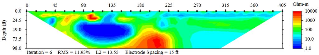
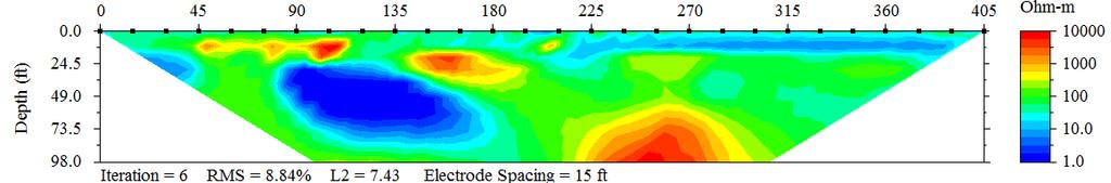
10 How GPR Does Work? 10

11 Tomball LPF-1 LPF-2 Pearland Lidar elevation map showing major Houston Faults 11

12 12

13 A schematic cross-section of a growth fault Figure 1a 13

14 14

15 MAIN HOCKLEY FAULT AT HWY. 290 N Up Down 15

16 Shopping Mall being built UP Down L1 Highway 290-East Bound 16
17 2005 field mapping with resistivity survey locations L6 L7 U FAULT SCARP D N L3 L5 FAULT Westbound 290 L2 L1 FAULT SCARP L4 Patched Asphalt Eastbound (A GPR profile is taken along Line 1) Union Pacific Railroad 17

18 W Fault Scarp E L1 Profile Major Crack Location Resistivity profiles at Hockley Fault L2 Profile 18


19 Resistivity Profiles Across the Main Hockley Fault NW SE Sand Silt/Silty Sand Clay/Silty Sand Sand L5 Profile Sand Silt/Silty Sand L6 Profile 19
20 NW Fault Scarp SE NW Silt/Silty Sand Sand SE Resistivity profile across the Main Hockley Fault 20

21 NW Ft Fault Scarp Ft SE High L1 Amplitude GPR Profile across the fault scarp L1-This scarp did not have any resistivity anomaly. So it is NOT considered the main Hockley fault. Low 21

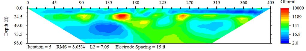
22 NW Ft SE Ft GPR Data Along Line 1 Low Amplitude High 22
23 FS L7 U D L6 U D N Westbound 290 L3 L5 U D L2 L4 U D L1 FS U D Patched Asphalt Eastbound Feet Location of Hockley fault determined by resistivity surveys 23 Union Pacific Railroad

24 Location of Fault Zone based on geophysics results 24


25 A April 2010 August 2010 B Hockley Fault Deformation POSTSCRIPT TO GEOPHYSICAL SURVEYS 25

26 Main Hockley Fault and its minor fault along east feeder MALL Minor Fault Main Fault 26


27 D C Minor faults immediately to the west of the main fault along the wet feeder 27

28 If you follow the main fault on the road towards the newly built building you will see the crack at the corner of the building! 28

29 LONG POINT FAULT AT MOOREHEAD STREET 29

30 30

31 NE Observed Fault Location Driveway SW Clay Sand Clay Resistivity imaging section across the LPF. 31

32 Down UP 32

33 A mansion is being built few houses west of Long Point Fault! 33
34 HWY. 249 Resistivity Resistivity Line Line 34

35 A View of Tomball Fault at Demolished Beckondorf Middle School-View to East RL UP Down 35

36 Major cracks and subsidence School West Entrance N 125 Ft Fault Zone S Sand Caliche Resistivity imaging data across the Tomball Fault 36

37 View looking SW A BLIND TEST OF RESISTIVITY SURVEY OVER PEARLAND FAULT IN SE OF HOUSTON 37

38 SW Borehole locations FAULT ZONE NE Sand Clay Silty Clay Clay Resistivity Line 1 SW 10 feet spacing NE Sand Clay Silty Clay Clay Resistivity Line 2 Resistivity imaging data across Pearland Fault 38

39 Gamma Ray data overlaid on the resistivity profiles 39

40 Foundation problems explored via GPR in one of these houses in Spring, Texas 40

41 N EX-1 EX-2 EX Decayed wood floor in the living room! 41
42 EX-1 N EXCAVATIONS EX-2 EX-3 Living room with wood flooring 3D GPR survey line Concrete Patio GPR SURVEY DESIGN F/P Post-tension cables embedded in the concrete foundation 42

43 N DAISY GPR survey with 1500 MHz antenna 43

44 N High Amplitude Scale Low 3D GPR DATA FROM 1500 MHz ANTENNA 44

45 GPR SURVEY CART WITH 400 MHz Antenna 45 N
46 N Amplitude Scale EX-1 High EX-2 EX3 Excavated Void Figure 6 Low 3D GPR DATA for 400 MHz Antenna: 3 ft depth slice 46

47 N EX-1 High EX-2 EX-3 Low Amplitude Scale 3D GPR Data for antenna 400 MHz: 5 Ft depth slice 47

48 EX-3 Void 48


49 October 8, 2008 October 28, 2008 Water depth is one inch Water depth is 4 inch Excavated void location based on the GPR data 49
50 2008 Annual Precipitation at Northwest Houston. Houston: Bush Intercontinental Airport Average Temp Departure Precipitation Departure January " +0.94" February " +1.02" March " -0.95" April " -2.14" May " -0.58" June " -3.29" July " -2.09" August " +3.62" September " +7.74" October " +4.17" November " -1.27" December " -2.01" ANNUAL " +5.16" 7.74 INCH 4.17 INCH 50

51 FRENCH DRAINAGE INSTALLATION 51

52 Foundation problems few miles away from The Alamo, San Antonio 52

53 Foundation Case Study GPR Unit View to the NE 53
54 R1 Geophysical Profiles Around the Building N R2 Air-conditioning unit BUILDING X R3 R4 STAIRS R5 54

55 ACU GPR surveys around the building: Note the significant cracks 55

56 Note the significant cracks Stairs 56


57 N Ft Ft Poor quality GPR data due to the high conductivity of the soil S Two GPR Profiles Ft Poor quality GPR data due to the high conductivity of the soil 57

58 Micro-resistivity survey along the building 58

59 NW Corner Air-Conditioner SW Corner Void Line R1 Conductivity data-converted from the resistivity data 59

60 Resistivity survey along Line R3 60

61 W SW Corner Next to stairs E Clay Subsidence Clay Sand Conductivity profile along R3 61

62 Line 5 A view to the NW 62

63 SE Corner B-2 NE Corner Sand Clay Sand Sharp Contact- Anomaly? Conductivity profile along R5 63


64 RESULTS OF THE FOUNDATION STUDY Using micro-resistivity surveys, we not only located a number of areas of granular soil where substantial amounts of moisture have accumulated. The resistivity data also indicated the presence of an abandoned sewer main under the building that was not known to be present at the time, but has been verified on old base maps. GPR results did not yield any information. 64
 Mean discharge: 53 cfs (1,500")
65 D U USGS Well Where is all the water coming from into the Barton Springs Pool?! 4th largest spring system in Texas Water temperature: 68 F (22 C) Mean discharge: 53 cfs (1,500 lps) (105 acre-feet/day) 65

66 Geological Map of Barton Springs Pool U D Eliza A Parthenia Zenobia B 66


67 Dye tracing as far as 13 miles away 67


68 In the 1830s, William Barton owned the land, which included the three springs to which he gave his three daughters names: Parthenia, Eliza and Zenobia. 68

69 Natural-Potential Method (NP) Utilizes the earth s naturalelectric field at the ground surface to detect and map groundwater pathways and geologic features, such as faults, fractures, conduits, caves Movement of water Target: Seepage, Voids 69
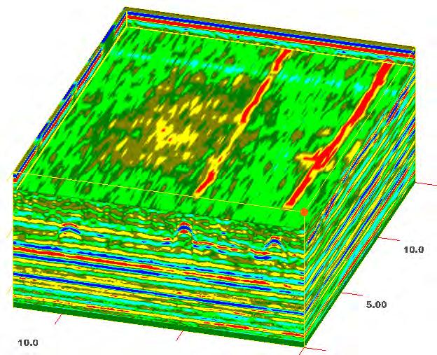
70 mv 70
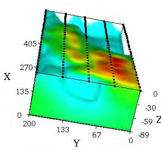
71 Locations of NP and Resistivity Profiles at Barton Springs Eliza N1 Old Mill NP NP and Resistivity Springs Fault U D L2 L3 L4 L5 L6 L7 L8 L9 L10 L11 71


72 Endangered Salamanders of Barton Springs 72
73 NP Data at the Barton Springs Pool mv W South Bank Positive NP Anomaly E mv North Bank Water main hole Feet Fault 73


74 NP Profiles Over Aerial View of Pool N N1 Eliza Main Barton Old Mill NP profile data Springs Fault Flow-path Gate to the Pool 74

75 Pecan Trees L4 L3 L2 L6 Star Kitchen Tent L5 L4 50-Ft 75
76 W South Gate Line 2-Resistivity Data E Clay-filled Cave? Clay layers Resistivity Data mv Line 2-NP Data NP anomaly Feet 76

77 W E LINE 2 LINE 3 Significant fracture or fault LINE 4 LINE 5 77

78 mv NP Data along Line 8 on a dry day NP Data Line 8 after a big storm Correlation of an NP anomaly taken along Line 8 on a dry day and on a day after a stormy rain 78
79 Extra Resistivity Line 79

80 Resistivity Imaging Data West South Gate P E C A N T R E E S East 80
 N South Gate")
81 3D Resistivity Data in the E-W Direction (view from north to south) N South Gate 81

82 Concluding Remarks We think we located number of conduits and caves in the Barton Springs area; We also think that we located a significant fracture or fault that appears to control the flow of the water into the pool. Now, it is pool time! 82

83 83

84 FRONT YARD GEOPHYSICS IN AUSTIN 84

85 Fixed Sinkholes R2 NP line Resistivity line R1 Road patches 1 Location of Geophysical Lines 85

86 Natural Potential Survey Design NP Data Point

87 Location of Resistivity Line R1 87

88 W RES ISTIVITY PROFILE R1 E mv NP DATA Both data sets indicate no anomaly! FEET 88

89 N RESISTIVITY PROFILE R2 S mv NP DATA Both data sets indicate significant anomalies! Feet 89

90 Q: Do karstic features represent a hazard to the Austin Community? Q: What do you think? 90

91 Q: Or do we represent a hazard to the Karstic Community? Taken from 2010 NSS Journal with permission from Dr. George Veni 91
92 Final Remarks-1 EGA A key factor conducting a successful survey is to select the proper geophysical methods for the site conditions. There is no one geophysical tool that can be considered the proverbial silver bullet which can uniquely locate, delineate, and characterize all hazards.. 92
93 Final Remarks-2 EGA But clearly geophysics can play a role in advance in reducing the risk many hazards present to public safety and health. Properly planned and executed, a geophysical survey can provide a wealth of information cost effectively that could NOT be obtained otherwise, such as drilling and/or surface sampling. 93
94 EGA Let s remember: Geophysics is just another 94
Active growth faults cutting the land surface around the
 SPECIAL N e a r - ssection: u r f a c e gn e oe ap rh -ys su irc fs a c e g e o p h y s i c s Geophysical mapping of the Hockley growth fault in northwest Houston, USA, and recent surface observations
Although most karstic regions
 Urban Geophysics: Geophysical Signature of Mount Bonnell Fault and Its Karstic Features in Austin, TX by Mustafa Saribudak, Environmental Geophysics Associates, Austin, TX Although most karstic regions
Mustafa Saribudak Environmental Geophysics Associates, 2000 Cullen Avenue, Number 7, Austin, TX, 78757, USA,
 THE MILLION DOLLAR QUESTION: WHICH GEOPHYSICAL METHODS LOCATE CAVES BEST OVER THE EDWARDS AQUIFER? A POTPOURRI OF CASE STUDIES FROM SAN ANTONIO AND AUSTIN, TEXAS, USA Mustafa Saribudak Environmental Geophysics
EMERGENCY INVESTIGATION OF EXTREMELY LARGE SINKHOLES, MAOHE, GUANGXI, CHINA
 EMERGENCY INVESTIGATION OF EXTREMELY LARGE SINKHOLES, MAOHE, GUANGXI, CHINA Mingtang Lei, Xiaozhen Jiang, Zhende Guan Institute of Karst Geology, CAGS, Guilin, China, mingtanglei@hotmail.com Yongli Gao
Bedrock Associated with the Ranch House at the Tallgrass Prairie National Preserve, Chase County, Kansas
 Bedrock Associated with the Ranch House at the Tallgrass Prairie National Preserve, Chase County, Kansas KGS OPEN-FILE REPORT 2008-10 KANSAS GEOLOGICAL SURVEY 1930 Constant Ave. - Campus West Lawrence,
This report was prepared by Klohn Crippen Consultants Ltd. for Alberta Transportation Central Region under Contract No. CE053/2000.
 Alberta Transportation Central Region #401, 4902 51 Street Red Deer, Alberta T4N 6K8 June 7, 2002 Mr. Melvin Mayfield, P.Eng. Project Engineer Dear Mr. Mayfield: Central Region Landslide Assessment Site
LBJWC - Sinkhole Lesson
 LBJWC - Sinkhole Lesson Concept Caves and sinkholes are major openings in the ground that recharge water to the Edwards Aquifer. Objective - Students will: 1) identify a sinkhole, cave, fracture, fault,
Background. Valley fills Sites in the Area. Construction over Mine Spoil Fills
 Construction over Mine Spoil Fills Wayne A. Karem, PhD, PE, PG, D.GE 2014 KSPE Annual Conference Background Strip mining; mountaintop and contour mining Creates huge quantities of mine spoil The mine spoil
A Preliminary Geophysical Reconnaissance Mapping of Emirau Ground Water Resource, Emirau Island, New Ireland Province, PNG
 A Preliminary Geophysical Reconnaissance Mapping of Emirau Ground Water Resource, Emirau Island, New Ireland Province, PNG Geological Survey Division of Mineral Resources Authority (MRA) Papua New Guinea
Amistad Dam Investigation and Oversight: Karst- Founded Dam on the USA-Mexico Border
 Amistad Dam Investigation and Oversight: Karst- Founded Dam on the USA-Mexico Border Brook Brosi, CPG, PG USACE Lisa Nowicki Perks, PG USACE Kimberly Heenan, PE AECOM US Army Corps of Engineers BUILDING
1 PROJECT BACKGROUND. August 14, Alberta Transportation Central Region #401, Street Red Deer, Alberta T4N 6K8
 August 14, 2013 Alberta Transportation Central Region #401, 4902 51 Street Red Deer, Alberta T4N 6K8 Mr. Dennis Grace, P.Eng. Construction Engineer Dear Mr. Grace: Central Region Geohazard Assessment 2013
KARST MAPPING WITH GEOPHYSICS AT MYSTERY CAVE STATE PARK, MINNESOTA
 KARST MAPPING WITH GEOPHYSICS AT MYSTERY CAVE STATE PARK, MINNESOTA By Todd A. Petersen and James A. Berg Geophysics Program Ground Water and Climatology Section DNR Waters June 2001 1.0 Summary A new
Lecture 15: Subsidence
 Lecture 15: Subsidence Key Questions 1. How does removal of groundwater cause subsidence on a regional scale? 2. Under what conditions does a building sink into sediment? 3. Why do clays consolidate more
New Jersey Department of Transportation Extreme Weather Asset Management Pilot Study
 New Jersey Department of Transportation Extreme Weather Asset Management Pilot Study Overview Prepared for: June 26, 2018 Introduction Overview of Pilot Study New Jersey s Climate New Jersey s Transportation
INVESTIGATIONS OF LARGE SCALE SINKHOLE COLLAPSES, LAIBIN, GUANGXI, CHINA
 INVESTIGATIONS OF LARGE SCALE SINKHOLE COLLAPSES, LAIBIN, GUANGXI, CHINA Yongli Gao Department of Geological Sciences, Center for Water Research, University of Texas at San Antonio, TX 78249, USA, yongli.gao@utsa.edu
Hydrogeology of Karst NE Wisconsin. Dr. Maureen A. Muldoon UW-Oshkosh Geology Department
 Hydrogeology of Karst NE Wisconsin Dr. Maureen A. Muldoon UW-Oshkosh Geology Department WI Bedrock Outline Karst Landscapes Existing WQ Data Flow in Karst Aquifers Overview of Silurian Aquifer Water Level
Geophysical signatures of Barton Springs (Parthenia, Zenobia and Eliza) of the Edwards Aquifer, Austin, Texas
 of the Edwards Aquifer, Austin, Texas") Geophysical signatures of Barton Springs (Parthenia, Zenobia and Eliza) of the Edwards Aquifer, Austin, Texas Mustafa Saribudak, Nico M. Hauwert & Alf Hawkins Carbonates and Evaporites ISSN 0891-2556 DOI
Geophysical signatures of Barton Springs (Parthenia, Zenobia and Eliza) of the Edwards Aquifer, Austin, Texas Mustafa Saribudak, Nico M. Hauwert & Alf Hawkins Carbonates and Evaporites ISSN 0891-2556 DOI
CCR Rule Annual Inspection Report (cont.) 2
 2") The inspection findings consisted of maintenance items and items that were not observed to be signs or potential signs of significant structural weakness. No deficiencies or disrupting conditions that
The inspection findings consisted of maintenance items and items that were not observed to be signs or potential signs of significant structural weakness. No deficiencies or disrupting conditions that
QUANTITY, MARCH 1962
 BASE-FLOW STUDIES, GUADALUPE RIVER COMAL COUNTY, TEXAS QUANTITY, MARCH 1962 TEXAS WATER COMMISSION BULLETIN 6503 MARCH 1965 TEXAS WATER COMMISSION Joe William D E 0. F. Dent Carter, Chairman Berger, Commissioner
Mapping Faults With Lightning, Natural-Sourced Electromagnetics (NSEM) Louis J. Berent Dynamic Measurement, LLC
 Louis J. Berent Dynamic Measurement, LLC") Mapping Faults With Lightning, Natural-Sourced Electromagnetics (NM) Louis J. Berent Dynamic Measurement, LLC 23 June 2015 Validating NM with 2-D Resistivity Imaging Profiling & Ground Penetrating Radar
Mapping Faults With Lightning, Natural-Sourced Electromagnetics (NM) Louis J. Berent Dynamic Measurement, LLC 23 June 2015 Validating NM with 2-D Resistivity Imaging Profiling & Ground Penetrating Radar
Environmental Geology Lab 5 - Mass Wasting Hazards
 Environmental Geology Lab 5 - Mass Wasting Hazards page - 1 Many landslides, slope failures or sinkholes (collapse structures formed in terrain underlain by limestone rocks) occur during or immediately
REDWOOD VALLEY SUBAREA
 Independent Science Review Panel Conceptual Model of Watershed Hydrology, Surface Water and Groundwater Interactions and Stream Ecology for the Russian River Watershed Appendices A-1 APPENDIX A A-2 REDWOOD
GEOLOGY, SOILS, AND SEISMICITY
 4.9 GEOLOGY, SOILS, AND SEISMICITY 4.9.1 Introduction Information about the geological conditions and seismic hazards in the study area was summarized in the FEIR, and was based on the Geotechnical Exploration
IMAGING OF DEEP SINKHOLES USING THE MULTI-ELECTRODE RESISTIVITY IMPLANT TECHNIQUE (MERIT) CASE STUDIES IN FLORIDA
 CASE STUDIES IN FLORIDA") IMAGING OF DEEP SINKHOLES USING THE MULTI-ELECTRODE RESISTIVITY IMPLANT TECHNIQUE (MERIT) CASE STUDIES IN FLORIDA David Harro The G3 Group, 2509 Success Drive, Suite 1, Odessa, FL 33556, david.harro@geo3group.com
IMAGING OF DEEP SINKHOLES USING THE MULTI-ELECTRODE RESISTIVITY IMPLANT TECHNIQUE (MERIT) CASE STUDIES IN FLORIDA David Harro The G3 Group, 2509 Success Drive, Suite 1, Odessa, FL 33556, david.harro@geo3group.com
Applied Geophysics for Environmental Site Characterization and Remediation
 Applied Geophysics for Environmental Site Characterization and Remediation MSECA Webinar September 24, 2015 John Mundell, P.E., L.P.G. Ryan Brumbaugh, L.P.G. MUNDELL & ASSOCIATES, INC. Webinar Objective
IV. ENVIRONMENTAL IMPACT ANALYSIS E. GEOLOGY AND SOILS
 IV. ENVIRONMENTAL IMPACT ANALYSIS E. GEOLOGY AND SOILS The following section is a summary of the geotechnical report conducted for the Proposed Project. The Geotechnical Engineering Investigation (the
Chapter 5 CALIBRATION AND VERIFICATION
 Chapter 5 CALIBRATION AND VERIFICATION This chapter contains the calibration procedure and data used for the LSC existing conditions model. The goal of the calibration effort was to develop a hydraulic
Geophysical Methods for Screening and Investigating Utility Waste Landfill Sites in Karst Terrain
 Geophysical Methods for Screening and Investigating Utility Waste Landfill Sites in Karst Terrain Gary Pendergrass, PE, RG, F.NSPE Principal Geological Engineer Kansas City Geotechnical Conference 2017
Slope Stability Evaluation Ground Anchor Construction Area White Point Landslide San Pedro District Los Angeles, California.
 Slope Stability Evaluation Ground Anchor Construction Area White Point Landslide San Pedro District Los Angeles, California Submitted To: Mr. Gene Edwards City of Los Angeles Department of Public Works
Monitoring and Characterization of the Meadowview Lane Landslide: Boyd County, KY
 Monitoring and Characterization of the Meadowview Lane Landslide: Boyd County, KY Matt Crawford Appalachian Coalition for Geologic Hazards in Transportation 13 th Annual Technical Forum Harrisonburg, VA
Gotechnical Investigations and Sampling
 Gotechnical Investigations and Sampling Amit Prashant Indian Institute of Technology Gandhinagar Short Course on Geotechnical Investigations for Structural Engineering 12 14 October, 2017 1 Purpose of
Sabal Trail Pipeline Project Evaluation of Karst Topography and Sinkhole Potential for Pipeline and Facilities
 November 11, 2014 Sabal Trail Pipeline Project Evaluation of Karst Topography and Sinkhole Potential for Pipeline and Facilities Gulf Interstate Engineering Attention: Mr. Denys Stavnychyi - Project Engineer
WHITE POINT LANDSLIDE GEOTECHNICAL INVESTIGATION November 29, 2012 Status Report
 Gary Lee Moore, P.E., City Engineer Vince Jones, P.E., Deputy City Engineer WHITE POINT LANDSLIDE GEOTECHNICAL INVESTIGATION November 29, 2012 Status Report White Point Landslide Geotechnical Investigation
High Resolution Geophysics: A Better View of the Subsurface. By John Jansen, P.G., Ph.D., Aquifer Science and Technology
 High Resolution Geophysics: A Better View of the Subsurface By John Jansen, P.G., Ph.D., Aquifer Science and Technology Geologist Use Only Part of the Information Available To Them Most Geologist rely
An Introduction to Field Explorations for Foundations
 An Introduction to Field Explorations for Foundations J. Paul Guyer, P.E., R.A. Paul Guyer is a registered mechanical engineer, civil engineer, fire protection engineer and architect with over 35 years
IV. ENVIRONMENTAL IMPACT ANALYSIS G. GEOLOGY AND SOILS
 IV. ENVIRONMENTAL IMPACT ANALYSIS G. GEOLOGY AND SOILS The following section is a summary of the geotechnical report conducted for the proposed project. The Report of Geotechnical Investigation Proposed
TRC1504: Alternative Uses of Ground Penetrating Radar in Highway in Construction and Maintenance. Elisha Wright-Kehner, P.E.
 TRC1504: Alternative Uses of Ground Penetrating Radar in Highway in Construction and Maintenance Elisha Wright-Kehner, P.E. Why GPR? Practicality Non-invasive (Non-destructive Testing - NDT) Real-time
Table 5-1 Sampling Program Summary for Milltown Ford Avenue Redevelopment Area, NJ.
 Table 5- Sampling Program Summary for Milltown Ford Avenue Redevelopment Area, NJ. Transformer Pads (9 pads: PAD 9) Evaluate if PCBs presently exist in soils adjacent to, and/or beneath the transformer
Land Subsidence. Land subsidence is defined as the lowering of the land surface.
 Land Subsidence Land subsidence is defined as the lowering of the land surface. Many different factors can cause the land surface to subside. Subsidence can occur rapidly due to: a sinkhole or under ground
10. GEOTECHNICAL EXPLORATION PROGRAM
 Geotechnical site investigations should be conducted in multiple phases to obtain data for use during the planning and design of the tunnel system. Geotechnical investigations typically are performed in
ENGINEER S CERTIFICATION OF FAULT AREA DEMONSTRATION (40 CFR )
") PLATTE RIVER POWER AUTHORITY RAWHIDE ENERGY STATION BOTTOM ASH TRANSFER (BAT) IMPOUNDMENTS LARIMER COUNTY, CO ENGINEER S CERTIFICATION OF FAULT AREA DEMONSTRATION (40 CFR 257.62) FOR COAL COMBUSTION RESIDUALS
PLATTE RIVER POWER AUTHORITY RAWHIDE ENERGY STATION BOTTOM ASH TRANSFER (BAT) IMPOUNDMENTS LARIMER COUNTY, CO ENGINEER S CERTIFICATION OF FAULT AREA DEMONSTRATION (40 CFR 257.62) FOR COAL COMBUSTION RESIDUALS
Sabal Trail Pipeline Project Evaluation of Karst Topography and Sinkhole Potential for Pipeline and Facilities
 November 11, 2014 Sabal Trail Pipeline Project Evaluation of Karst Topography and Sinkhole Potential for Pipeline and Facilities Gulf Interstate Engineering Attention: Mr. Denys Stavnychyi - Project Engineer
Finding Large Capacity Groundwater Supplies for Irrigation
 Finding Large Capacity Groundwater Supplies for Irrigation December 14, 2012 Presented by: Michael L. Chapman, Jr., PG Irrigation Well Site Evaluation Background Investigation Identify Hydrogeologic Conditions
Multimethod Geophysical Characterization of Fault Systems for Environmental Planning
 Multimethod Geophysical Characterization of Fault Systems for Environmental Planning John A. Mundell and Ryan P. Brumbaugh, Mundell & Associates, Inc. Brian Ham and Ric Federico, EnSafe Inc. Talk Outline
The results of KCB s site inspection observations and our recommendations for further work are presented herein.
 July 14, 2015 Central Region 401, 4902 51 Street Red Deer, Alberta T4N 6K8 Mr. Tony Penney, P.Eng. Construction Engineer Dear Mr. Penney: June 25, 2015 Site Inspection Report The above site was visited
January 17, 2008 File:
 January 17, 2008 File: 15-85-73 Alberta Infrastructure and Transportation Room 301, Provincial Building 9621-96 Avenue Peace River, Alberta T8S 1T4 Attention: Mr. Ed Szmata PEACE REGION (SWAN HILLS AREA)
Investigation of shallow leakage zones in a small embankment dam using repeated resistivity measurements
 Investigation of shallow leakage zones in a small embankment dam using repeated resistivity measurements Pontus Sjödahl 1, Sam Johansson 2, Torleif Dahlin 3 Resistivity measurements were carried out in
Engineering Geophysical Application to Mine Subsidence Risk Assessment
 Engineering Geophysical Application to Mine Subsidence Risk Assessment By: Kanaan Hanna, Sr. Mining Engineer Steve Hodges, Sr. Geophysicist Jim Pfeiffer, Sr. Geophysicist Dr. Keith Heasley, Professor West
ambiguity in earth sciences IESO Geophysics Section Eddy hartantyo, Lab Geofisika FMIPA UGM
 ambiguity in earth sciences IESO Geophysics Section Eddy hartantyo, Lab Geofisika FMIPA UGM Pelatihan Tahap II IESO Teknik Geologi UGM Februari 2009 1 Introduction Photos from http://www.eegs.org/whatis/
Geophysical Investigation of Foundation Condition of A Site in Ikere- Ekiti, Ekiti State, South-Western Nigeria
 Australian Journal of Basic and Applied Sciences, 5(9): 1852-1857, 2011 ISSN 1991-8178 Geophysical Investigation of Foundation Condition of A Site in Ikere- Ekiti, Ekiti State, South-Western Nigeria 1
2010/2011 Winter Weather Summary
 2010/2011 Winter Weather Summary Number of Days of Snow Alerts* Precipitation Snow Rain October 0 6 Trace.91 inches November 0 16 1.1 inches.47 inches December 2 20 17.9 inches 1.54 inches 7.5" first alert
Identified a possible new offset location where the customer is currently exploring drill options.
 GroundMetrics was hired to conduct a Full-Field Resistivity Survey for an oil and gas producer that needed to make crucial decisions to drive profitability at the location. The results saved them hundreds
Application of Ground Penetrating Radar for hydro-geological study
 Journal of Scientific & Industrial Research Vol. 65, February 2006, pp. 160-164 Application of Ground Penetrating Radar for hydro-geological study K K K Singh* Central Mining Research Institute, Dhanbad
Ground subsidence is a worldwide problem especially
 Ground Engineering: GPR A Case Study on Ground Subsidence Using Ground Penetrating Radar Nur Azwin Ismail and Rosli Saad Geophysics Section, School of Physics, Universiti Sains Malaysia Ground subsidence
UTC R189 GEOPHYSICAL ASSESSMENT OF KARST ACTIVITY. Neil L. Anderson
 GEOPHYSICAL ASSESSMENT OF KARST ACTIVITY by Neil L. Anderson UTC R189 A University Transportation Center Program at Missouri University of Science & Technology Disclaimer The contents of this report reflect
Wisconsin s Hydrogeology: an overview
 2012 Soil and Water Conservation Society Conference Stevens Point, WI Feb 9, 2012 Wisconsin s Hydrogeology: an overview Ken Bradbury Wisconsin Geological and Natural History Survey University of Wisconsin-Extension
California 120 Day Precipitation Outlook Issued Tom Dunklee Global Climate Center
 California 120 Day Precipitation Outlook Issued 11-01-2008 Tom Dunklee Global Climate Center This is my second updated outlook for precipitation patterns and amounts for the next 4 s of the current rainy
August 31, 2006 Embankment Failure Debris Flow at the Cascades Development Haywood County, North Carolina. Introduction. Findings
 August 31, 2006 Embankment Failure Debris Flow at the Cascades Development Haywood County, North Carolina Introduction North Carolina Geological Survey (NCGS) staff members visited the site of the August
IV. ENVIRONMENTAL IMPACT ANALYSIS E. GEOLOGY AND SOILS
 IV. ENVIRONMENTAL IMPACT ANALYSIS E. GEOLOGY AND SOILS The following analysis is based on the Geotechnical Investigation Report, Proposed Mid-Rise Multi- Family Residential Development Project Wetherly
BUFFALO RIVER COALITION PO Box 101, Jasper, AR (870)
") BUFFALO RIVER COALITION PO Box 101, Jasper, AR 72641 (870) 446-5783 buffalowatershed@gmail.com Presentation before Arkansas Pollution Control and Ecology Commission, April 29, 2016 by Richard Mays on behalf
BUFFALO RIVER COALITION PO Box 101, Jasper, AR 72641 (870) 446-5783 buffalowatershed@gmail.com Presentation before Arkansas Pollution Control and Ecology Commission, April 29, 2016 by Richard Mays on behalf
Hazard Mapping Along the Dead Sea Shoreline
 FIG Working Week in Marrakech, Morocco 18-22 May 2011 Hazard Mapping Along the Dead Sea Shoreline Rami Al-Ruzouq, Abdullah Al-Zuobi, AbdEl-Rahman Abueladas, Emad Akkawi Department of Surveying and Geomatics
LANDSLIDES IN THE WHITE MOUNTAIN (GEOTECHNICAL STUDIES AND ENGINEERING TESTS)
") J. Al Azhar University Gaza 2004, Vol. 7, NO. 2 P 15-26 LANDSLIDES IN THE WHITE MOUNTAIN (GEOTECHNICAL STUDIES AND ENGINEERING TESTS) Isam G. Jardaneh (1), Jalal Al-Dabeek (2), Abdel hakeem Al-Jawhari
J. Al Azhar University Gaza 2004, Vol. 7, NO. 2 P 15-26 LANDSLIDES IN THE WHITE MOUNTAIN (GEOTECHNICAL STUDIES AND ENGINEERING TESTS) Isam G. Jardaneh (1), Jalal Al-Dabeek (2), Abdel hakeem Al-Jawhari
25th International Conference on Ground Control in Mining
 ANALYTICAL INVESTIGATION OF SHAFT DAMAGES AT WEST ELK MINE Tim Ross, Senior Associate Agapito Associates, Inc. Golden, CO, USA Bo Yu, Senior Engineer Agapito Associates, Inc. Grand Junction, CO, USA Chris
DATA REPORT GEOTECHNICAL INVESTIGATION GALVESTON CRUISE TERMINAL 2 GALVESTON, TEXAS
 DATA REPORT GEOTECHNICAL INVESTIGATION GALVESTON CRUISE TERMINAL 2 GALVESTON, TEXAS SUBMITTED TO PORT OF GALVESTON 123 ROSENBERG AVENUE, 8TH FLOOR GALVESTON, TEXAS 77553 BY HVJ ASSOCIATES, INC. HOUSTON,
TAKING THE MYSTERY OUT OF USACE S ER DRILLING IN EARTH EMBANKMENT DAMS AND LEVEES
 TAKING THE MYSTERY OUT OF USACE S ER 1110-1-1807 DRILLING IN EARTH EMBANKMENT DAMS AND LEVEES 237 237 237 217 217 217 200 200 200 80 119 27 252 174.59 1 255 255 255 0 0 0 163 163 163 131 132 122 239 65
ELECTRICAL RESISTIVITY SURVEY OF INTREPID POTASH INJECTION WELL SITE: EDDY COUNTY, NEW MEXICO
 NCKRI REPORT OF INVESTIGATION 3 ELECTRICAL RESISTIVITY SURVEY OF INTREPID POTASH INJECTION WELL SITE: EDDY COUNTY, NEW MEXICO www.nckri.org NATIONAL CAVE AND KARST RESEARCH INSTITUTE REPORT OF INVESTIGATION
KANSAS GEOLOGICAL SURVEY Open File Report LAND SUBSIDENCE KIOWA COUNTY, KANSAS. May 2, 2007
 KANSAS GEOLOGICAL SURVEY Open File Report 2007-22 LAND SUBSIDENCE KIOWA COUNTY, KANSAS Prepared by Michael T. Dealy L.G., Manager, Wichita Operations SITE LOCATION The site was approximately four miles
Prepared By: John Blair Sean Donahue Celeste Hoffman Kimberly Klinkers Megan Slater
 Prepared By: John Blair Sean Donahue Celeste Hoffman Kimberly Klinkers Megan Slater Green River Basin Location Green River Basin Stratigraphic Correlation Chart showing Study Map Units Sample of Existing
Foundation pile and cavity detection by the 3D directional borehole radar system, ReflexTracker
 Foundation pile and cavity detection by the 3D directional borehole radar system, ReflexTracker K. Wada, S. Karasawa, K. Kawata, T. Ueki Matsunaga Geo-survey Co., Ltd. 1-23-1 Ooi, 140-0014, Tokyo, Japan
Fast and Furious Rebuilding and Widening the I-90 West Corridor
 Fast and Furious Rebuilding and Widening the I-90 West Corridor Peter Foernssler, P.E., S.E. Deputy Chief, Illinois Tollway Marty Ross, P.E. Design Corridor Manager, TranSystems Jason Wenberg, P.E. Construction
patersongroup Consulting Engineers April 20, 2010 File: PG1887-LET.01R Novatech Engineering Consultants Suite 200, 240 Michael Cowpland Drive
 patersongroup April 20, 2010 File: PG1887-LET.01R Novatech Engineering Consultants Suite 200, 240 Michael Cowpland Drive Ottawa, Ontario K2M 1P6 Attention: Mr. Adam Thompson Consulting Engineers 28 Concourse
Florida s Karst Geology
 Florida s Karst Geology Orange Creek Basin Interagency Working Group Public Workshop, November 5 th, 2015 Harley Means, P.G. Assistant State Geologist Florida Geological Survey Karst Karst a type of topography
Current Climate Trends and Implications
 Current Climate Trends and Implications Dr. Mark Seeley Professor emeritus Department of Soil, Water, and Climate University of Minnesota St Paul, MN 55108 Crop Insurance Conference September 12, 2018
Sequence Stratigraphy of the Upper Cretaceous Niobrara Formation, A Bench, Wattenberg Field, Denver Julesburg Basin, Colorado*
 Sequence Stratigraphy of the Upper Cretaceous Niobrara Formation, A Bench, Wattenberg Field, Denver Julesburg Basin, Colorado* Lisa E. Remington LaChance 1 and Mark C. Robinson 1 Search and Discovery Article
Local Flood Hazards. Click here for Real-time River Information
 Local Flood Hazards Floods of the White River and Killbuck Creek are caused by runoff from general, and/or intense rainfall. Other areas of flooding concern are from the Boland Ditch and Pittsford Ditch.
UTC R161. Geotechnical Site Characterization of Transportation Construction Sites and Structures. Neil L. Anderson. Derek B. Apel.
 Geotechnical Site Characterization of Transportation Construction Sites and Structures Assessment Of Karst Activity At Highway Construction Sites In Greene And Jefferson Counties, Missouri, Using The Electrical
AWRA PMAS Engineers Club of Philadelphia. A Geologic Perspective on Stormwater
 AWRA PMAS Engineers Club of Philadelphia A Geologic Perspective on Stormwater Toby J. Kessler, P.G. Hydrogeologist Trevor G. Woodward, P.G. Engineering Geologist September 10, 2014 Gilmore & Associates,
design, construction, operation, and maintenance of the BAP is consistent with recognized and generally accepted good engineering standards.
 design, construction, operation, and maintenance of the BAP is consistent with recognized and generally accepted good engineering standards. In addition to the field inspection, Associated Engineers, Inc.
Guidelines for Site-Specific Seismic Hazard Reports for Essential and Hazardous Facilities and Major and Special-Occupancy Structures in Oregon
 Guidelines for Site-Specific Seismic Hazard Reports for Essential and Hazardous Facilities and Major and Special-Occupancy Structures in Oregon By the Oregon Board of Geologist Examiners and the Oregon
MICHIGAN GEOLOGICAL SURVEY Coastal Navigator Training St. Joseph, Michigan What do we know about anthropogenic impact(s) to Lake Michigan shorelines?
 to Lake Michigan shorelines?") MICHIGAN GEOLOGICAL SURVEY Coastal Navigator Training St. Joseph, Michigan What do we know about anthropogenic impact(s) to Lake Michigan shorelines? Review of a 12 year shoreline study and today, what
MICHIGAN GEOLOGICAL SURVEY Coastal Navigator Training St. Joseph, Michigan What do we know about anthropogenic impact(s) to Lake Michigan shorelines? Review of a 12 year shoreline study and today, what
What can they teach each other? Geary M. Schindel, P.G. Chief Technical Officer Edwards Aquifer Authority San Antonio, Texas
 Cavers and Geologists What can they teach each other? Geary M. Schindel, P.G. Chief Technical Officer Edwards Aquifer Authority San Antonio, Texas Karst is a landscape where dissolution is the dominant
GPR SURVEYS AT SOME 700 YEARS-OLD STRUCTURES IN THE OLD CITY OF CAIRO, EGYPT.
 GPR SURVEYS AT SOME 700 YEARS-OLD STRUCTURES IN THE OLD CITY OF CAIRO, EGYPT. Mohamed G. El-Behiry Geophysics Department, Faculty of Science, Cairo University, Giza, Egypt. Abstract Remediation and restoration
Geophysics for Environmental and Geotechnical Applications
 Geophysics for Environmental and Geotechnical Applications Dr. Katherine Grote University of Wisconsin Eau Claire Why Use Geophysics? Improve the quality of site characterization (higher resolution and
CCR Rule Compliance: Innovative Use of Geophysics to Certify Landfill Stability and Site Groundwater Monitoring Wells
 CCR Rule Compliance: Innovative Use of Geophysics to Certify Landfill Stability and Site Groundwater Monitoring Wells Gary Pendergrass, PE, RG Principal Geological Engineer Missouri Waste Control Coalition
Hydrogeological Assessment for Part of Lots 2 and 3, Concession 5, Township of Thurlow, County of Hastings 1.0 INTRODUCTION. 1.
 February 10,2017 25506400 Ontario Ltd. Foxboro, ON Attention: Brad Newbatt Re: Hydrogeological Assessment for Part of Lots 2 and 3, Concession 5, Township of Thurlow, County of Hastings 1.0 INTRODUCTION
Location of Abandoned Water Wells by Magnetic Surveys over the Edwards Aquifer in the San Antonio Area, Texas. Abstract. 1.
 Bulletin of the Location of Abandoned Water Wells by Magnetic Surveys over the Edwards Aquifer in the San Antonio Area, Texas Mustafa Saribudak 1, Alf Hawkins 1 and Roger Andrade 2 1 Environmental Geophysics
GM 1.4. SEG/Houston 2005 Annual Meeting 639
 storage recovery project in Leyden, Colorado Kristofer Davis *, Yaoguo Li, Michael Batzle, and Bob Raynolds** Center for Gravity, Electrical, and Magnetic Studies, Department of Geophysics, Colorado School
Flood Risk Assessment
 Flood Risk Assessment February 14, 2008 Larry Schick Army Corps of Engineers Seattle District Meteorologist General Assessment As promised, La Nina caused an active winter with above to much above normal
GEOLOGY AND SOILS. This chapter summarizes geologic and geotechnical aspects of the site as they relate to the Project.
 9 GEOLOGY AND SOILS INTRODUCTION This chapter summarizes geologic and geotechnical aspects of the site as they relate to the Project. This chapter utilizes information from the following reports prepared
Converse Consultants Geotechnical Engineering, Environmental & Groundwater Science, Inspection & Testing Services
 Converse Consultants Geotechnical Engineering, Environmental & Groundwater Science, Inspection & Testing Services July 27, 2017 Ms. Rebecca Mitchell Mt. San Antonio College Facilities Planning & Management
Setting MOUNTAIN HOUSE NEIGHBORHOODS I AND J INITIAL STUDY 5. ENVIRONMENTAL CHECKLIST 6. GEOLOGY AND SOILS. Issue
 Issue Less Than Significant or No Impact Potential Significant Impact Adequately Addressed in MEIR MEIR Required Additional Review: No Significant Impact Less Than Significant Impact Due to Mitigation
PEACE RIVER EAST HILL - HWY 2:60 (PH2) SELECT PHOTOGRAPHS August 22, 2007 File: Photo E003. Station May 2007
 SELECT PHOTOGRAPHS August 22, 2007 File: Photo E003. Station May 2007") Photo E003 0+000 Viewing looking upslope at Site 4 from highway. Conditions unchanged from 2006. Photo E018 0+000 Localized erosion within road fill on upslope side of highway. Photo E022 0+250 Looking
Photo E003 0+000 Viewing looking upslope at Site 4 from highway. Conditions unchanged from 2006. Photo E018 0+000 Localized erosion within road fill on upslope side of highway. Photo E022 0+250 Looking
Chiang Rai Province CC Threat overview AAS1109 Mekong ARCC
 Chiang Rai Province CC Threat overview AAS1109 Mekong ARCC This threat overview relies on projections of future climate change in the Mekong Basin for the period 2045-2069 compared to a baseline of 1980-2005.
3.18 GEOLOGY AND SOILS
 3.18 GEOLOGY AND SOILS This section discusses geologic resource concerns as they relate to the environment, public safety, and project design both during construction and after completion of the project.
Geologging Imagery, Applications and Geological Interpretation. Shea Altadonna 1, Jim Fulton 2, E.I.T.
 Geologging Imagery, Applications and Geological Interpretation Shea Altadonna 1, Jim Fulton 2, E.I.T. 1 Geologist, Advanced Construction Techniques Inc. 1000 N. West St. Ste 1200, Wilmington, DE 19801;
A Case Study on Ground Subsidence Using Ground Penetrating Radar
 2012 International Conference on Environmental, Biomedical and Biotechnology IPCBEE vol.41 (2012) (2012) IACSIT Press, Singapore A Case Study on Ground Using Ground Penetrating Radar Nur Azwin Ismail +
THE MINISTRY OF ENERGY AND ENERGY INDUSTRIES MINERALS DIVISION MINE DESIGN TEMPLATE OPERATOR NAME: OPERATOR ADDRESS: PHONE NUMBER: FACSIMILE:
 THE MINISTRY OF ENERGY AND ENERGY INDUSTRIES MINERALS DIVISION MINE DESIGN TEMPLATE 1.0 GENERAL INFORMATION OPERATOR NAME: OPERATOR ADDRESS: PHONE NUMBER: FACSIMILE: NAME OF CONTACT: CELLULAR PHONE: EMAIL
Development of geophysical investigation for verifying treatment efficiency of underground cavities
 Development of geophysical investigation for verifying treatment efficiency of underground cavities Hasan A. Kamal* Kuwait Institute for Scientific Research, Infrastructure Risk and Reliability Program,
Downtown Anchorage Seismic Risk Assessment & Land Use Regulations to Mitigate Seismic Risk
 Prepared for: The Municipality of Anchorage Planning Department and the Geotechnical Advisory Commission Downtown Anchorage Seismic Risk Assessment & Land Use Regulations to Mitigate Seismic Risk Prepared
HISTORY OF CONSTRUCTION FOR EXISTING CCR SURFACE IMPOUNDMENT PLANT GASTON ASH POND 40 CFR (c)(1)(i) (xii)
(1)(i) (xii)") HISTORY OF CONSTRUCTION FOR EXISTING CCR SURFACE IMPOUNDMENT PLANT GASTON ASH POND 40 CFR 257.73(c)(1)(i) (xii) (i) Site Name and Ownership Information: Site Name: E.C. Gaston Steam Plant Site Location:
HISTORY OF CONSTRUCTION FOR EXISTING CCR SURFACE IMPOUNDMENT PLANT GASTON ASH POND 40 CFR 257.73(c)(1)(i) (xii) (i) Site Name and Ownership Information: Site Name: E.C. Gaston Steam Plant Site Location: