What can they teach each other? Geary M. Schindel, P.G. Chief Technical Officer Edwards Aquifer Authority San Antonio, Texas
|
|
|
- Jeremy Watkins
- 5 years ago
- Views:
Transcription


1 Cavers and Geologists What can they teach each other? Geary M. Schindel, P.G. Chief Technical Officer Edwards Aquifer Authority San Antonio, Texas


2 Karst is a landscape where dissolution is the dominant geomorphic agent. It is characterized by sinkholes, sinking streams, caves, springs, and a well integrated subsurface drainage network d Neversink, North Alabama Dishman Lane sinkhole collapse, Bowling Green, Kentucky Photo Center for Cave and Karst Studies, Western Kentucky Univ.
3 Source: Living with Karst, AGI, 2002
4 Darcy s Law is the equation defining groundwater flow in equivalent porous media aquifers does it apply to karst? Q = KIA Jim Quinlan said the average caver knows more about groundwater flow in karst than most professionally trained geologists and engineers
5 Few colleges or universities offer specific course work in karst hydrology yet 20% to 30% of the US is karst and some states exceed more than 50%
6 Many karst aquifers contain unique biota Many were first brought to the attention of scientists by cavers


7 The cave maps produced by cavers often provide the basis for work by karst hydrologists, engineers, urban planners, biologists, environmental scientists, and regulators From Center for Cave and Karst Studies, Western Kentucky University Bowling Green, Kentucky


8 Cave maps often provide insight into the preferential flowpaths of a karst aquifer Honey Creek Cave, Comal County, Texas. Mapped length of cave is 19+ miles 1 mile Map provided by 1 mile Map provided by Kurt Menking, Bexar Grotto of NSS
9 W N E EDWARDS AQUIFER REGION S Drainage Area Artesian Zone KILOMETERS Location of the Edwards Aquifer in Texas
10 Figure 2 Cross Section of the Edwards Aquifer in Bexar County, Texas USA
11 Location of 2,000 gallon diesel fuel spill and Comal Springs - largest spring in western US with average discharge of 280 cfs Miles


12 Valdina Farm Sinkhole, Medina Co., Texas. A 150 foot pit and recharge feature. Picture above is during flood, picture to right is during normal conditions Catfish Farmer Well artesian well flowing at >30,000 gpm. Bexar County, Texas


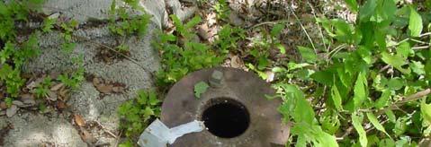
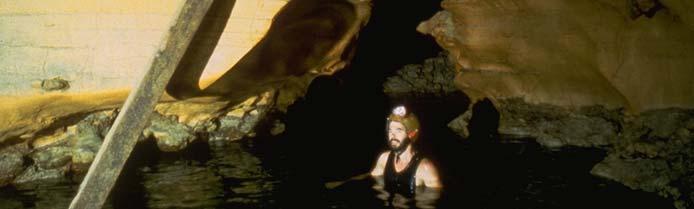
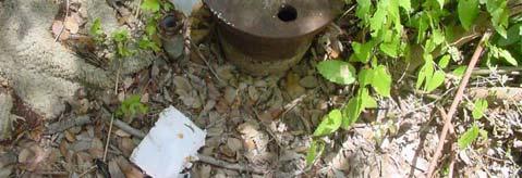
13 Quarry wall in Edwards Limestone Recharge feature 60 foot pit Abandoned well used as toilet by homeless Swimming in the aquifer
14 Cave maps often provide an insight into the preferential flowpaths in a karst aquifer Mapped length is 6.7 kilometers 4th longest cave in Texas Source: Elliott and Veni, 1994
15
16 S ill it l t d dj t t Di l f l d i f l ti Spill site located adjacent to quarry. Diesel fuel used in formulation o explosives in quarry. Depth to groundwater is 280 feet


17 8 per Billion Parts Jan 20-Jan 25-Jan 30-Jan 4-Feb Date 8 lion Parts per Bill Jan 20-Jan 25-Jan 30-Jan 4-Feb Date Miles
18 Tracer Test Sampling Points Recharge Zone Comal Springs Fault Trace %U %U NBU Yard Eosine (Panther Canyon Well) Spring Run 3 r Spring 7 r Spring Island Landa Lake %U NBU Well 5 Golf Course Artesian Zone Old Channel Uranine (LCRA Landa Lake Outlet Well)
19 Eosine Breakthrough Curve on Filter Fluorometer at Spring Run rts per Billion Par Breakthrough at 2:04 pm 6 Injected at 11:37 am :00 AM 12:00 PM 3:00 PM 6:00 PM 9:00 PM 12:00 AM
20 Uranine Tracer Test Results in the Landa Park Area Uranine Eosine Y %U NBU Well 5 r Panther Canyon Well r LCRA Well Y
21 Breakthrough Curves at Landa Lake Outlet Intensity Eosine From Panther Canyon Well Comal Springs Discharge ( cfs) Uranine from LCRA Well Mar 23-Mar 24-Mar 25-Mar 26-Mar 27-Mar 28-Mar 29-Mar 30-Mar 31-Mar 1-Apr 2-Apr 3-Apr 4-Apr 5-Apr Uranine results indicate photodegradation of dye as it crosses Landa Lake
22 Comal Springs Tracer Test Estimated Travel Time Using Velocity Equation from Darcy slaw v = Ki/n T = 7,000 ft 2 /day from kriging gin BEG ROI 250 b = 500 feet (thickness) n = 0.3 porosity from BEG ROI 238 i = gradient = 0.01 ft/ft (21.7 feet of head over 2,000 feet) v= Ki/n = 0.47 feet per day or 11 year travel time from LCRA Well to Landa Lake actual time from tracer test data was 36 hours
23 Comal Springs Tracer Test Estimation of Conduit Size Using Continuity Equation A = Q/V A = Cross-sectional area in square feet Q = Discharge in cubic feet second (360 cfs) (50% of discharge from artesian zone) (50% of discharge from recharge zone) V = Velocity, feet per second (0.023 ft/sec for artesian zone) ( ft/sec for recharge zone)
24 Comal Springs Tracer Test Number of Conduits Diameter of Conduits Reynolds Number Diameter of Conduits Reynolds Number Artesian Zone Artesian Zone Recharge Zone Recharge Zone ft 212, ft 120, ft 63, ft 38, ft 20,937 6 ft 13,958 All Reynolds number are > 2,000; therefore, flow is turbulent and dd Darcy s Law does not apply to this portion of aquifer
25 Cavers and Geologists What is a caver? What is a karst specialist? Someone who is a member of the NSS, NSS CDS, or NACD How do you find a caver? Local chapters of the NSS can be found from the NSS web page at Someone through training and experience who has gained a certain level of competence in addressing karst problems. Currently, there is no certifications for specialists in the field of karst State cave surveys can usually be contacted through cavers? Most cavers are willing to help and commonly volunteer maps and assistance once they understand what you want Some states maintain a list of recognized experts in karst Professionals should seek out the opportunity to enter caves with cavers or taking specialized training in karst
26 Cavers and Geologists Cavers need to start considering Karst specialists need to treat themselves professionals and stop cavers with respect and stop thinking of themselves as looking at them as if they just someone who just crawled out crawled out from under a rock from under a rock Cavers don t realize the importance of their maps and observations Karst specialists don t realize the importance of the years of field work locating springs and mapping in many states Relationships with cavers need to be developed before you need them before the next big spill
27 Cavers and Geologists Cavers need to reach out to the State regulatory agencies and non-specialist consultants need to have access to karst specialists and use them Cavers need to learn for karst problems environmental regulations and reporting methods State surveys need to collect karst related data spring and cave locations, maps, contact names, etc.
LBJWC - Sinkhole Lesson
 LBJWC - Sinkhole Lesson Concept Caves and sinkholes are major openings in the ground that recharge water to the Edwards Aquifer. Objective - Students will: 1) identify a sinkhole, cave, fracture, fault,
Chapter 14: Groundwater. Fig 14.5b
 Chapter 14: Groundwater Fig 14.5b OBJECTIVES Recognize that groundwater is a vital source of accessible freshwater. Describe how groundwater forms below the water table. Explain the origin of aquifers,
Soils, Hydrogeology, and Aquifer Properties. Philip B. Bedient 2006 Rice University
 Soils, Hydrogeology, and Aquifer Properties Philip B. Bedient 2006 Rice University Charbeneau, 2000. Basin Hydrologic Cycle Global Water Supply Distribution 3% of earth s water is fresh - 97% oceans 1%
GAM Run by Ali H. Chowdhury Ph.D., P.G. Texas Water Development Board Groundwater Resources Division (512)
") GAM Run 7-18 by Ali H. Chowdhury Ph.D., P.G. Texas Water Development Board Groundwater Resources Division (512) 936-0834 July 13, 2007 EXECUTIVE SUMMARY The groundwater availability model for the Hill
GAM Run 7-18 by Ali H. Chowdhury Ph.D., P.G. Texas Water Development Board Groundwater Resources Division (512) 936-0834 July 13, 2007 EXECUTIVE SUMMARY The groundwater availability model for the Hill
Groundwater Flow in the Edwards Aquifer: Comparison of Groundwater Modeling and Dye Trace Results
 Groundwater Flow in the Edwards Aquifer: Comparison of Groundwater Modeling and Dye Trace Results Brian A. Smith 1, Brian B. Hunt 1, and Geary M. Schindel 2 Abstract The Edwards Aquifer of central Texas
VITA February M.Sc., Geography, concentration Karst hydrogeology and environmental geology, Western Kentucky University; July 1985.
 VITA February 2014 GEORGE VENI, Ph.D. Texas Professional Geoscientist License No. 682 507 E. Chapman Carlsbad, New Mexico 88220-9383 U.S.A. 210-863-5919, gveni@nckri.org Education Ph.D., Geology, concentration
11/22/2010. Groundwater in Unconsolidated Deposits. Alluvial (fluvial) deposits. - consist of gravel, sand, silt and clay
 deposits. - consist of gravel, sand, silt and clay") Groundwater in Unconsolidated Deposits Alluvial (fluvial) deposits - consist of gravel, sand, silt and clay - laid down by physical processes in rivers and flood plains - major sources for water supplies
Groundwater in Unconsolidated Deposits Alluvial (fluvial) deposits - consist of gravel, sand, silt and clay - laid down by physical processes in rivers and flood plains - major sources for water supplies
WATER ON AND UNDER GROUND. Objectives. The Hydrologic Cycle
 WATER ON AND UNDER GROUND Objectives Define and describe the hydrologic cycle. Identify the basic characteristics of streams. Define drainage basin. Describe how floods occur and what factors may make
Geology 103 Planet Earth (QR II), Laboratory Exercises 1. Groundwater
, Laboratory Exercises 1. Groundwater") Geology 103 Planet Earth (QR II), Laboratory Exercises 1 Student Name: Section: Karst Landform: Groundwater Anyone who has viewed Chinese landscape scroll paintings will recognize that the mountains are
Geology 103 Planet Earth (QR II), Laboratory Exercises 1 Student Name: Section: Karst Landform: Groundwater Anyone who has viewed Chinese landscape scroll paintings will recognize that the mountains are
Groundwater. (x 1000 km 3 /y) Reservoirs. Oceans Cover >70% of Surface. Groundwater and the. Hydrologic Cycle
 Reservoirs. Oceans Cover >70% of Surface. Groundwater and the. Hydrologic Cycle") Chapter 13 Oceans Cover >70% of Surface Groundwater and the Hydrologic Cycle Oceans are only 0.025% of Mass Groundwater Groundwater is liquid water that lies in the subsurface in fractures in rocks and
Chapter 13 Oceans Cover >70% of Surface Groundwater and the Hydrologic Cycle Oceans are only 0.025% of Mass Groundwater Groundwater is liquid water that lies in the subsurface in fractures in rocks and
QUANTITY, MARCH 1962
 BASE-FLOW STUDIES, GUADALUPE RIVER COMAL COUNTY, TEXAS QUANTITY, MARCH 1962 TEXAS WATER COMMISSION BULLETIN 6503 MARCH 1965 TEXAS WATER COMMISSION Joe William D E 0. F. Dent Carter, Chairman Berger, Commissioner
Lecture Outlines PowerPoint. Chapter 5 Earth Science 11e Tarbuck/Lutgens
 Lecture Outlines PowerPoint Chapter 5 Earth Science 11e Tarbuck/Lutgens 2006 Pearson Prentice Hall This work is protected by United States copyright laws and is provided solely for the use of instructors
Florida s Karst Geology
 Florida s Karst Geology Orange Creek Basin Interagency Working Group Public Workshop, November 5 th, 2015 Harley Means, P.G. Assistant State Geologist Florida Geological Survey Karst Karst a type of topography
Groundwater. (x 1000 km 3 /y) Oceans Cover >70% of Surface. Groundwater and the. Hydrologic Cycle
 Oceans Cover >70% of Surface. Groundwater and the. Hydrologic Cycle") Chapter 17 Oceans Cover >70% of Surface Groundwater and the Hydrologic Cycle Vasey s Paradise, GCNP Oceans are only 0.025% of Mass Groundwater Groundwater is liquid water that lies in the subsurface in
Chapter 17 Oceans Cover >70% of Surface Groundwater and the Hydrologic Cycle Vasey s Paradise, GCNP Oceans are only 0.025% of Mass Groundwater Groundwater is liquid water that lies in the subsurface in
Groundwater Hydrology
 EXERCISE 12 Groundwater Hydrology INTRODUCTION Groundwater is an important component of the hydrologic cycle. It feeds lakes, rivers, wetlands, and reservoirs; it supplies water for domestic, municipal,
Karst Sub-basin Delineation via Dye Trace Study near Turnhole Bend, Mammoth Cave National Park
 Western Michigan University ScholarWorks at WMU Honors Theses Lee Honors College 4-18-2017 Karst Sub-basin Delineation via Dye Trace Study near Turnhole Bend, Mammoth Cave National Park Jake Tholen Western
Wisconsin s Hydrogeology: an overview
 2012 Soil and Water Conservation Society Conference Stevens Point, WI Feb 9, 2012 Wisconsin s Hydrogeology: an overview Ken Bradbury Wisconsin Geological and Natural History Survey University of Wisconsin-Extension
JOURNAL OF ENVIRONMENTAL HYDROLOGY
 JOURNAL OF ENVIRONMENTAL HYDROLOGY The Electronic Journal of the International Association for Environmental Hydrology On the World Wide Web at http://www.hydroweb.com VOLUME 13 2005 THE EFFECT OF SINKHOLES
 http://dx.doi.org/10/1061/40698(2003)19 Green, J., Pavlish, J., Leete, J., and Alexander, Jr., E. (2003) Quarrying Impacts on Groundwater Flow Paths. Sinkholes and the Engineering and Environmental Impacts
STUDY GUIDE FOR CONTENT MASTERY. Movement and Storage of Groundwater
 Groundwater SECTION 10.1 Movement and Storage of Groundwater In your textbook, read about the hydrosphere, precipitation and groundwater, and groundwater storage. Use the following terms to complete the
Karst found mostly in limestone (rock with at least 50% carbonate minerals), depends on 1) permeability & porosity
, depends on 1) permeability & porosity") KARST LANDFORMS produced by weathering & erosion in regions of carbonate rocks and evaporites processes called karstification mainly below ground surface predominantly underground drainage poorly-developed
KARST LANDFORMS produced by weathering & erosion in regions of carbonate rocks and evaporites processes called karstification mainly below ground surface predominantly underground drainage poorly-developed
FRACTURE TRACES AND PRODUCTIVITY OF MUNICIPAL WELLS IN THE MADISON LIMESTONE, RAPID CITY, SOUTH DAKOTA
 Proceedings of the South Dakota Academy of Science, Vol. 87 (2008) 261 FRACTURE TRACES AND PRODUCTIVITY OF MUNICIPAL WELLS IN THE MADISON LIMESTONE, RAPID CITY, SOUTH DAKOTA Perry H. Rahn Department of
The Favorability of Florida s Geology to Sinkhole Formation
 Florida Geological Survey The Favorability of Florida s Geology to Sinkhole Formation Clint Kromhout Alan Baker October 24, 2017 Subsidence Report Database Map of Subsidence Incident Reports taken from
Essentials of Geology, 11e
 Essentials of Geology, 11e Groundwater Chapter 10 Instructor Jennifer Barson Spokane Falls Community College Geology 101 Stanley Hatfield Southwestern Illinois Co Jennifer Cole Northeastern University
Hydrogeology of Karst NE Wisconsin. Dr. Maureen A. Muldoon UW-Oshkosh Geology Department
 Hydrogeology of Karst NE Wisconsin Dr. Maureen A. Muldoon UW-Oshkosh Geology Department WI Bedrock Outline Karst Landscapes Existing WQ Data Flow in Karst Aquifers Overview of Silurian Aquifer Water Level
Accepted for publication by Kentucky Section of the American Institute of Professional Geologists
 August 25, 2016 Relationships between surface and ground water velocities determined from dye trace experiments in McConnell Springs and Preston s Cave Spring, Lexington, Fayette County, Kentucky Laura
Hydrologic Influences of the Blanco River on the Trinity and Edwards Aquifers, Central Texas, USA
 Hydrologic Influences of the Blanco River on the and Aquifers, Central Texas, USA B.A. Smith, B.B. Hunt, A.G. Andrews, J.A. Watson, M.O. Gary, D.A. Wierman and A.S. Broun Abstract The Blanco River of central
Example Quiz on Earthquakes
 Example Quizzes, Tests, and Review Information A Example Quiz on Earthquakes Quizzes such as this one are given at the beginning of each lab. 1. The point beneath the Earth s surface at which an earthquake
 Red River Flooding June 2015 Caddo and Bossier Parishes Presented by: Flood Technical Committee Where the Rain Falls Matters I-30 versus I-20 I-20 Backwater and Tributary Floods (Localized) 2016 Flood
Test is over no later than 9:40 p.m. There are 43 questions. Each is worth points, for a total of 100 points.
 Student name NOTE: Test 2 - Form B 3370:133 Section 001 SAMPLE Caves Count pages to make sure that you have all of them. Turn in this question sheet when done. Fill in all information requested on the
IDAWRA: Groundwater-flow model for the Wood River Valley aquifer system, south-central Idaho February 1, 2017, 11:30-1:00
 Idaho Section of the American Water Resources Association IDAWRA: Groundwater-flow model for the Wood River Valley aquifer system, south-central Idaho A three-dimensional numerical model of groundwater
APPENDIX 3B OCCURRENCE OF SIGNIFICANT RIVER ALLUVIUM AQUIFERS IN THE PLATEAU REGION
 Plateau Region Water Plan January 2011 APPENDIX 3B OCCURRENCE OF SIGNIFICANT RIVER ALLUVIUM AQUIFERS IN THE PLATEAU REGION Occurrence of Significant River Alluvium Aquifers in the Plateau Region Prepared
What is a water table? What is an aquifer? What is the difference between a spring and a well?
 CHAPTER 11 3 Water Underground SECTION The Flow of Fresh Water BEFORE YOU READ After you read this section, you should be able to answer these questions: What is a water table? What is an aquifer? What
6.1 Water. The Water Cycle
 6.1 Water The Water Cycle Water constantly moves among the oceans, the atmosphere, the solid Earth, and the biosphere. This unending circulation of Earth s water supply is the water cycle. The Water Cycle
Prentice Hall EARTH SCIENCE
 Prentice Hall EARTH SCIENCE Tarbuck Lutgens Running Water and Groundwater Running Water The Water Cycle Water constantly moves among the oceans, the atmosphere, the solid Earth, and the biosphere. This
Understanding Water Level Transducers. Texas Groundwater Summit San Antonio, TX 2018
 Understanding Water Level Transducers Texas Groundwater Summit San Antonio, TX 2018 Presented by Raymond L Straub Jr., P.G. Raymond L Straub Jr., P.G. Licensed Professional Geoscientist President of Straub
An Introduction to Field Explorations for Foundations
 An Introduction to Field Explorations for Foundations J. Paul Guyer, P.E., R.A. Paul Guyer is a registered mechanical engineer, civil engineer, fire protection engineer and architect with over 35 years
Underground Hydrology of the Commodore Mine Complex and Implications for Source Control. Jeff T. Graves
 Underground Hydrology of the Commodore Mine Complex and Implications for Source Control Jeff T. Graves Investigation Approach Purpose Determine location/s, quality and quantity of groundwater inflows into
Montana Bureau of Mines and Geology presents the 2009 SEMINAR SERIES. Trilby Cox, Seismologist University of California, San Diego
 presents the 2009 SEMINAR SERIES April 9, 2009 April 16, 2009 April 23, 2009 April 30, 2009 May 7, 2009 Up, Up, and Array Trilby Cox, Seismologist University of California, San Diego Pharmaceuticals in
 12 10 8 6 4 2 0 40-50 50-60 60-70 70-80 80-90 90-100 Fresh Water What we will cover The Hydrologic Cycle River systems Floods Groundwater Caves and Karst Topography Hot springs Distribution of water in
2. PHYSICAL SETTING FINAL GROUNDWATER MANAGEMENT PLAN. 2.1 Topography. 2.2 Climate
 FINAL GROUNDWATER MANAGEMENT PLAN 2. PHYSICAL SETTING Lassen County is a topographically diverse area at the confluence of the Cascade Range, Modoc Plateau, Sierra Nevada and Basin and Range geologic provinces.
Over the course of this unit, you have learned about different
 70 People and Weather TA L K I N G I T O V E R Over the course of this unit, you have learned about different aspects of earth s weather and atmosphere. Atmospheric scientists, climatologists, hydrologists,
KARST MAPPING WITH GEOPHYSICS AT MYSTERY CAVE STATE PARK, MINNESOTA
 KARST MAPPING WITH GEOPHYSICS AT MYSTERY CAVE STATE PARK, MINNESOTA By Todd A. Petersen and James A. Berg Geophysics Program Ground Water and Climatology Section DNR Waters June 2001 1.0 Summary A new
INVESTIGATIONS OF LARGE SCALE SINKHOLE COLLAPSES, LAIBIN, GUANGXI, CHINA
 INVESTIGATIONS OF LARGE SCALE SINKHOLE COLLAPSES, LAIBIN, GUANGXI, CHINA Yongli Gao Department of Geological Sciences, Center for Water Research, University of Texas at San Antonio, TX 78249, USA, yongli.gao@utsa.edu
Conceptual models for karstic aquifers
 Speleogenesis and Evolution of Karst Aquifers The Virtual Scientific Journal www.speleogenesis.info Conceptual models for karstic aquifers William B. White Department of Geosciences and Materials Research
Geophysical Case studies From Texas
 Geophysical Case studies From Texas 1 PRESENTATION OUTLINE Active Growth Faults in Metropolitan Houston 1. Hockley 2. Tomball 3. Long Point 4. Pearland Foundation Case Studies Karst Geophysics in Austin:
Hydraulic Impacts of Limestone Quarries and Gravel Pits. Jeff Green Minnesota DNR-Division of Ecological & Water Resources
 Hydraulic Impacts of Limestone Quarries and Gravel Pits Jeff Green Minnesota DNR-Division of Ecological & Water Resources The Hydraulic Impacts of Limestone Quarries and Gravel Pits Study was funded by
FORM A GEOGRAPHY 1114 LABORATORY FINAL EXAM Teaching Assistant SAMPLE Lab Meeting. Place all answers on the answer sheet; 2 points per question
 FORM A GEOGRAPHY 1114 NAME LABORATORY FINAL EXAM Teaching Assistant SAMPLE Lab Meeting Place all answers on the answer sheet; 2 points per question FORMULAS PPT = (PET-D) + S ± = Δ SOIL G = V H Q = V A
Per r y H. Rahn and J. School of Mines and Rapid City, S. Oak.
 s. Oak. of No. /07 by Oak. Per r y H. Rahn and J. School of Mines and Rapid City, S. Oak. P. Gries Technology in cooperation with the Water Resources Research Institute under Project No. A-O2/- SOAK S.
Ground-Water Flow through Porous Medium
 Soil & Ground Water Distribution Eastern USA Soil Moisture Belt Unsaturated (Vadose( = Aeration) Zone Capillary Fringe Water Table Saturated (Phreatic)) Zone Ground-Water Flow through Porous Medium Water
Geophysical Methods for Screening and Investigating Utility Waste Landfill Sites in Karst Terrain
 Geophysical Methods for Screening and Investigating Utility Waste Landfill Sites in Karst Terrain Gary Pendergrass, PE, RG, F.NSPE Principal Geological Engineer Kansas City Geotechnical Conference 2017
WWDC Green River Basin Plan II, Groundwater Study (Level I) WSGS USGS WRDS October 23, 2008 Green River Basin (GRB) Basin Advisory Group
 WSGS USGS WRDS October 23, 2008 Green River Basin (GRB) Basin Advisory Group") WWDC Green River Basin Plan II, Groundwater Study (Level I) WSGS USGS WRDS 2007-20092009 October 23, 2008 Green River Basin (GRB) Basin Advisory Group (BAG) Western Wyoming Community College, Rock Springs,
WWDC Green River Basin Plan II, Groundwater Study (Level I) WSGS USGS WRDS 2007-20092009 October 23, 2008 Green River Basin (GRB) Basin Advisory Group (BAG) Western Wyoming Community College, Rock Springs,
Dye Trace Report on Campbell Valley Creek
 Dye Trace Report on Campbell Valley Creek Housn and Winona Counties, Minnesota 2012-2013 John D. Barry 1, Jeffrey A. Green 1, Kelsi R. Ustipak 2, Betty Wheeler 2, and E. Calvin Alexander, Jr. 2 1 Minnesota
THE UNIVERSITY of TORONTO at SCARBOROUGH January, 2010 Department of Physical & Environmental Sciences
 THE UNIVERSITY of TORONTO at SCARBOROUGH January, 2010 Department of Physical & Environmental Sciences Environmental Science EES B02H3 PRINCIPLES OF GEOMORPHOLOGY The earth s surface form and its dynamic
Section 11.1 pp Where Mountains Form
 Section 11.1 pp. 236 237 Where Mountains Form Chapter 11 Set a Purpose: TE, p. 236 Reading Study Guide, p. 36 Discussion: TE, p. 236 Differentiating ion Reading Support: TE, p. 236 Visual Teaching Interpret
Prof. Stephen A. Nelson EENS 111. Groundwater
 Page 1 of 8 Prof. Stephen A. Nelson EENS 111 Tulane University Physical Geology This page last updated on 20-Oct-2003 is water that exists in the pore spaces and fractures in rock and sediment beneath
3.11 Floodplains Existing Conditions
 Other stormwater control practices may be needed to mitigate water quality impacts. In addition to detention facilities, other practices such as vegetated basins/buffers, infiltration basins, and bioswales
ES 105 Surface Processes I. Hydrologic cycle A. Distribution % in oceans 2. >3% surface water a. +99% surface water in glaciers b.
 ES 105 Surface Processes I. Hydrologic cycle A. Distribution 1. +97% in oceans 2. >3% surface water a. +99% surface water in glaciers b. >1/3% liquid, fresh water in streams and lakes~1/10,000 of water
Which map shows the stream drainage pattern that most likely formed on the surface of this volcano? A) B)
 B)") 1. When snow cover on the land melts, the water will most likely become surface runoff if the land surface is A) frozen B) porous C) grass covered D) unconsolidated gravel Base your answers to questions
1. When snow cover on the land melts, the water will most likely become surface runoff if the land surface is A) frozen B) porous C) grass covered D) unconsolidated gravel Base your answers to questions
Surface Processes Focus on Mass Wasting (Chapter 10)
") Surface Processes Focus on Mass Wasting (Chapter 10) 1. What is the distinction between weathering, mass wasting, and erosion? 2. What is the controlling force in mass wasting? What force provides resistance?
Surface Processes Focus on Mass Wasting (Chapter 10) 1. What is the distinction between weathering, mass wasting, and erosion? 2. What is the controlling force in mass wasting? What force provides resistance?
Introduction. Purpose
 Introduction The Edwards Aquifer is a karst aquifer in Central Texas whose hydrogeological properties are not fully understood. This is due to exaggerated heterogeneity of properties, high anisotropy due
Karst: multiple concepts for a unique geological object Dr Michel Bakalowicz
 Karst: multiple concepts for a unique geological object Dr Michel Bakalowicz Michel.Bakalowicz@gmail.com By way of an introduction The project of exploiting a lignite deposit in a limestone environment
Mustafa Saribudak Environmental Geophysics Associates, 2000 Cullen Avenue, Number 7, Austin, TX, 78757, USA,
 THE MILLION DOLLAR QUESTION: WHICH GEOPHYSICAL METHODS LOCATE CAVES BEST OVER THE EDWARDS AQUIFER? A POTPOURRI OF CASE STUDIES FROM SAN ANTONIO AND AUSTIN, TEXAS, USA Mustafa Saribudak Environmental Geophysics
Chapter 13. Groundwater
 Chapter 13 Groundwater Introduction Groundwater is all subsurface water that completely fills the pores and other open spaces in rocks, sediments, and soil. Groundwater is responsible for forming beautiful
KARST LANDSCAPES Geology & Hydrology. Dr. Gerald E. Weber
 KARST LANDSCAPES Geology & Hydrology Dr. Gerald E. Weber Aerial Oblique Photograph of the UCSC Campus looking northwest Karst A type of topography that is formed on limestone, gypsum, and other soluble
Groundwater Resources of Missouri. Cynthia Brookshire, R. G.
 Groundwater Resources of Missouri Cynthia Brookshire, R. G. GROUNDWATER... Water beneath the Earth s surface within a zone of saturation AQUIFER... A geologic formation or group of formations that are
Cave (location) radio: A paired radio transmitter and receiver that use very long wavelength, low-frequency radio signals to send a radio signal from
 radio: A paired radio transmitter and receiver that use very long wavelength, low-frequency radio signals to send a radio signal from") GLOSSARY Following are definitions for many karst-related technical terms, not all of which are used in this website. They are included as background information for readers who need access to technical
GLOSSARY Following are definitions for many karst-related technical terms, not all of which are used in this website. They are included as background information for readers who need access to technical
Although most karstic regions
 Urban Geophysics: Geophysical Signature of Mount Bonnell Fault and Its Karstic Features in Austin, TX by Mustafa Saribudak, Environmental Geophysics Associates, Austin, TX Although most karstic regions
Environmental Science EES B02H3 PRINCIPLES OF GEOMORPHOLOGY
 THE UNIVERSITY of TORONTO at SCARBOROUGH January, 2009 Department of Physical & Environmental Sciences Environmental Science EES B02H3 PRINCIPLES OF GEOMORPHOLOGY The earth s surface form and its dynamic
Laboratory Exercise #3 The Hydrologic Cycle and Running Water Processes
 Laboratory Exercise #3 The Hydrologic Cycle and Running Water Processes page - 1 Section A - The Hydrologic Cycle Figure 1 illustrates the hydrologic cycle which quantifies how water is cycled throughout
RIVERS, GROUNDWATER, AND GLACIERS
 RIVERS, GROUNDWATER, AND GLACIERS Delta A fan-shaped deposit that forms when a river flows into a quiet or large body of water, such as a lake, an ocean, or an inland sea. Alluvial Fan A sloping triangle
Geology 101 Lab Worksheet: Topographic Maps
 Geology 101 Lab Worksheet: Topographic Maps Name: Refer to the Topographic Maps Lab for the information you need to complete this worksheet (http://commons.wvc.edu/rdawes/g101ocl/labs/topomapslab.html).
Ground-Water Flow through Porous Medium. GEO 321 Lecture 14 Dr. J. S. Kite. Groundwater, Karst, and Caves
 GEO 321 Lecture 14 Dr. J. S. Kite The Rock Organ Organ Cave, Greenbrier Co., WV Groundwater, Karst, and Caves Soil & Ground Water Distribution Eastern USA Soil Moisture Belt Unsaturated (Aeration) Zone
Groundwater Sensitivity Regions of Kentucky
 Groundwater Sensitivity Regions of Kentucky by Kentucky Department for Environmental Protection Division of Water Groundwater Branch 1994 Interpreted by Joseph A. Ray James S. Webb Phillip W. O'dell Scale
Prediction of Areas Sensitive to Fertilizer Application in Thinly-Soiled Karst
 Prediction of Areas Sensitive to Fertilizer Application in Thinly-Soiled Karst Paul L. Richards, Jill Libby, Alex Kuhl, Tim Daniluk, Mike Lyzwa with contribution by the theses of Sarah Rhinehart, Cal Payne,
Applied Geophysics for Environmental Site Characterization and Remediation
 Applied Geophysics for Environmental Site Characterization and Remediation MSECA Webinar September 24, 2015 John Mundell, P.E., L.P.G. Ryan Brumbaugh, L.P.G. MUNDELL & ASSOCIATES, INC. Webinar Objective
What do you need for a Marathon?
 What do you need for a Marathon? Water and a snack? What about just a normal day? 1 flush = 3.5 gallons 1 flush = 3.5 gallons 10 minute shower = 20 gal 1 flush = 3.5 gallons 10 minute shower = 20 gal Jeans
STABILIZATION OF THE H&CT RAILWAY STONE DAM WALTER E. SKIPWITH, PE, JOYCE CRUM, AIA AND JOHN BAUMGARTNER, PE. Introduction.
 STABILIZATION OF THE H&CT RAILWAY STONE DAM WALTER E. SKIPWITH, PE, JOYCE CRUM, AIA AND JOHN BAUMGARTNER, PE I. A. Introduction General The Old Stone Dam is located in the upper reach of Cottonwood Creek
The Geology of the Cypress Creek Watershed, Wimberley Area, Texas
 The Geology of the Cypress Creek Watershed, Wimberley Area, Texas Alex S. Broun 1, Leslie Llado 1, Douglas A. Wierman 1,2, Andrew H. Backus 1 1 Hays Trinity Groundwater Conservation District, 2 Environmental
HID 362 MESLEKİ İNGİLİZCE 2
 HID 362 MESLEKİ İNGİLİZCE 2 Hafta 5 Prof. Dr. N. Nur ÖZYURT 2017-2018 Bahar Dönemi http://www.philippe-crochet.com/galerie/karst/details/18/lapiaz-et-sites-ruiniformes/236104/rr-14-0032-pic-saint-loupherault-figures-de-karstification-sur-la-crete-ouest
Old Oilfields vs. New Homes, Wells Case Studies, Proposed Solutions
 Old Oilfields vs. New Homes, Wells Case Studies, Proposed Solutions Patricia Billingsley, Brownfields Manager, Oklahoma Corporation Commission John Harrington, Director of Water Resources, Association
Masters Theses & Specialist Projects
 Western Kentucky University TopSCHOLAR Masters Theses & Specialist Projects Graduate School 12-2010 The Hydrology of the Carroll Cave-Toronto Springs System: Identifying and Examining Source Mixing through
Dye Trace Report Gorman Creek
 Dye Trace Report Gorman Creek Trace: March Wabasha County, Minnesota Jeffrey A. Green 1, Arew Luhmann 2,3, Scott Alexaer 2, Betty Wheeler 2, a E. Calvin Alexaer, Jr. 2 1 Minnesota Department of Natural
9/23/2013. Introduction CHAPTER 7 SLOPE PROCESSES, LANDSLIDES, AND SUBSIDENCE. Case History: La Conchita Landslide
 Introduction CHAPTER 7 SLOPE PROCESSES, LANDSLIDES, AND SUBSIDENCE Landslide and other ground failures posting substantial damage and loss of life In U.S., average 25 50 deaths; damage more than $3.5 billion
UTILITY REPORT FOR THORNTON SELF STORAGE THORNTON, COLORADO
 UTILITY REPORT FOR THORNTON SELF STORAGE THORNTON, COLORADO Prepared by: Bowman Consulting 63 Park Point Dr. Suite 1 Golden, CO 841 (33)-81-29 June 29, 215 Revised August 14, 215 Revised September 3, 215
Preventing New Groundwater Pollution Problems from Old Oilfield Areas. Oklahoma Corporation Commission
 Preventing New Groundwater Pollution Problems from Old Oilfield Areas Patricia Billingsley, Brownfields Manager, Oklahoma Corporation Commission Last year I presented a case study about subdivision water
MOVING THE NATIONAL PARK SERVICE CAVE AND KARST PROGRAM FORWARD - IDENTIFYING AND UNDERSTANDING PARK RESOURCES
 MOVING THE NATIONAL PARK SERVICE CAVE AND KARST PROGRAM FORWARD - IDENTIFYING AND UNDERSTANDING PARK RESOURCES Dale L. Pate Geologic Resources Division National Park Service P.O. Box 25287 Denver, Colorado
Chapter 14. Groundwater
 Chapter 14 Groundwater Importance of groundwater! Groundwater is water found in the pores of soil and sediment, plus narrow fractures in bedrock! Groundwater is the largest reservoir of fresh water that
What we will cover. The Hydrologic Cycle. River systems. Floods. Groundwater. Caves and Karst Topography. Hot springs
 Fresh Water What we will cover The Hydrologic Cycle River systems Floods Groundwater Caves and Karst Topography Hot springs On a piece of paper, put these reservoirs of water in to order from largest to
Study of heterogeneous vertical hyporheic flux via streambed temperature at different depths
 168 Remote Sensing and GIS for Hydrology and Water Resources (IAHS Publ. 368, 2015) (Proceedings RSHS14 and ICGRHWE14, Guangzhou, China, August 2014). Study of heterogeneous vertical hyporheic flux via
L-31N Seepage Management Field Test
 Miami-Dade Limestone Products Association 13292 N.W. 118 th Avenue Miami, FL 33178 L-31N Seepage Management Field Test The Performance of a Partially Penetrating Seepage Barrier along the L-31N Canal July
WKSS. Western Kentucky Speleological Survey. Annua I Report John E. Mylroie, editor. College of Environmental Sciences Murray State University
 WKSS Western Kentucky Speleological Survey Annua I Report 1980 John E. Mylroie, editor College of Environmental Sciences Murray State University 1 Murray State University Printing Services Murray, Kentucky
Engineers Edge, LLC PDH & Professional Training
 510 N. Crosslane Rd. Monroe, Georgia 30656 (770) 266-6915 fax (678) 643-1758 Engineers Edge, LLC PDH & Professional Training Copyright, All Rights Reserved Engineers Edge, LLC Pipe Flow-Friction Factor
GIS in Water Resources Fall 2015 CE 394K.3
 GIS in Water Resources Fall 2015 CE 394K.3 Term Project: Using GIS to apply Paramelle s method for finding ground water in karst terrain Patricia Bobeck December 4, 2015 1 Introduction and Background Jean-Baptiste
9/13/2011 CHAPTER 9 AND SUBSIDENCE. Case History: La Conchita Landslide. Introduction
 CHAPTER 9 SLOPE PROCESSES, LANDSLIDES, AND SUBSIDENCE Case History: La Conchita Landslide La Conchita: small coastal community 80 km (50 mi) northwest of Los Angeles Landslide occurred on January 10, 2005
Today I will describe the groundwater/surface water interaction in the CRB in Mosier basin.
 Today I will describe the groundwater/surface water interaction in the CRB in Mosier basin. 1 Ken Lite, studying groundwater resource in Mosier basin since 1980 s (photo by A. Bouchier) 2012 with Jonathan
Quadratic and Other Inequalities in One Variable
 Quadratic and Other Inequalities in One Variable If a quadratic equation is not in the standard form equaling zero, but rather uses an inequality sign ( , ), the equation is said to be a quadratic
Karst Topography In order to understand karst topography we must first have a basic understanding of the water cycle, the formation of limestone (carb
 Karst Topography The formation of caves and other associated features in limestone bedrock is called karst topography. Limestone, a sedimentary rock made mostly of the mineral calcite and small amounts
Groundwater. Earth Chapter 17
 Groundwater Earth Chapter 17 Chapter 17 Groundwater Importance of Groundwater Groundwater is water found in the pores of soil and sediment, plus narrow fractures in bedrock Groundwater and the Hydrosphere