WWDC Green River Basin Plan II, Groundwater Study (Level I) WSGS USGS WRDS October 23, 2008 Green River Basin (GRB) Basin Advisory Group
|
|
|
- Osborne Bates
- 5 years ago
- Views:
Transcription
 Laramie, Wyoming")
1 WWDC Green River Basin Plan II, Groundwater Study (Level I) WSGS USGS WRDS October 23, 2008 Green River Basin (GRB) Basin Advisory Group (BAG) Western Wyoming Community College, Rock Springs, Wyoming Keith E. Clarey, P.G. Senior Geohydrologist Wyoming State Geological Survey (WSGS) Laramie, Wyoming
2 Introduction Green River Basin (GRB) Plan II, Groundwater Study (Level I) Commenced in June 2007 Draft Project Report October 2008 Final Project Report - December 1, 2008
3 Introduction (cont d) Cooperative Water Study Wyoming Water Development Commission (WWDC) Wyoming Water Development Office (WWDO) Wyoming State Geological Survey (WSGS) U.S. Geological Survey (USGS) Water Resources Data System (WRDS) Surface Water Consultant WWC Engineering, Laramie Other interested parties including GRB BAG
4 GRB Groundwater Study Team WWDO Project Manager Chace Tavelli WSGS Laramie Laramie Keith Clarey USGS Cheyenne Tim Bartos WRDS University of Wyoming Steve Gray
5
6 GRB Groundwater Study Identify & inventory the aquifers within the drainage basin area Determine 3-dimensional configuration of the aquifers (outcrop areas, geologic structures, & depths) Estimate aquifer recharge rates, storage quantities, & discharge rates
7 GRB Groundwater Study (cont d) Identify areas with interaction between groundwater & surface water Assess the quantity & quality of groundwater available in the aquifers Investigate the usage of groundwater in the basin
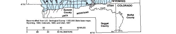
8 Geologic Setting of the GRB Complex structural lb basin with hf folds, faults, & uplifts Deepest depth in the basin exceeds 35,000 feet Central basin areas are like a layer cake of bedrock GRB formations from Precambrian to Quaternary in age (170 geologic units) Wyoming 105 GIS geologic units Colorado 40 GIS geologic units Utah 25 GIS geologic units
9

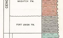


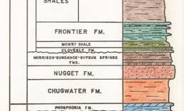
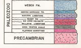
10 GRB - Stratigraphic Column from: WSGS CRS-2 (1973) and WSGS MS-41 (1993)
11
12
13
14
15 Percentages of GRB Map Area Cenozoic Aquifer System 83% WY 80% WY-CO CO-UT Mesozoic Aquifer System 12% WY 11% WY-CO CO-UT Paleozoic Aquifer System 1% WY 1% WY-CO CO-UT Precambrian Aquifer System 4% WY 7% WY-CO CO-UT
16
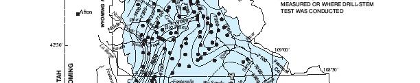
17 Wyoming GRB Wells and Springs There are 13,002 groundwater permits on file with the WSEO as of December 2007 and most of these permits are for wells in the Wyoming GRB There are 1,202 USGS mapped springs in the Wyoming GRB
18
19
20
21
22
23
24
25
26
27
28
29
30
31
32
33
34
35
36 Aquifer Recharge & Discharge Recharge to Aquifers Infiltration from precipitation & snowmelt Seepage from streams, ponds, lakes, reservoirs, & rivers Infiltration of irrigation water Discharge from Aquifers Evapotranspiration Discharge from springs Discharge to streams & rivers Subsurface leakage from an aquifer to adjacent aquifers Pumpage from water & coal bed natural gas (CBNG) wells Estimates of Recharge & Discharge Rates Rates range from less than 1 inch to 12 inches per year in the GRB.
37 Aquifer Storage Very little is known about water storage in the aquifers. Estimates of aquifer storage were made based on a set of assumptions about aquifer properties. Estimates of storage incorporate volume calculations based on areal extent and thickness of the aquifer.
38


39 Wasatch Aquifer Potentiometric Map


40 Wasatch Aquifer Total Dissolved Solids Map
41 Summary The WSGS-USGS USGS-WRDS team is completing the groundwater study for the updated Green River Basin Plan II (2009). Aquifers in the GRB have been inventoried and characterized for quantity and quality of groundwater and hydrogeologic properties.
42 Summary (cont d) The groundwater team is coordinating activities with the surface water team (WWC Engineering and others). The updated groundwater study for the GRB Plan II is currently a draft report. The final groundwater report is due out in December 2008.

")

43 Thank you, Questions? Keith E. Clarey (307) , x241
MIDDLE NORTH PLATTE GLENDO WATERSHED LEVEL 1 STUDY JUNE 2016
 MIDDLE NORTH PLATTE GLENDO WATERSHED LEVEL 1 STUDY JUNE 2016 WHAT IS A WATERSHED STUDY? o A COMPREHENSIVE EVALUATION, analysis and description of the land and water resources within a watershed o GATHERS
Wyoming State Geological Survey Thomas A. Drean, Director and State Geologist
 Wyoming State Geological Survey Thomas A. Drean, Director and State Geologist Platte River Basin Water Plan Update Groundwater Study Level I (2009 2013) Available Groundwater Determination Technical Memorandum
Hydrogeology and Simulated Effects of Future Water Use and Drought in the North Fork Red River Alluvial Aquifer: Progress Report
 Hydrogeology and Simulated Effects of Future Water Use and Drought in the North Fork Red River Alluvial Aquifer: Progress Report Developed in partnership with the Oklahoma Water Resources Board S. Jerrod
Available Ground Water Determination Task 3E
 Technical Memorandum Subject: Powder/Tongue River Basin Plan Available Ground Water Determination Task 3E Date: March 2002 Prepared By: HKM Engineering Inc. INTRODUCTION A qualitative summary of the ground
GAM Run by Ali H. Chowdhury Ph.D., P.G. Texas Water Development Board Groundwater Resources Division (512)
") GAM Run 7-18 by Ali H. Chowdhury Ph.D., P.G. Texas Water Development Board Groundwater Resources Division (512) 936-0834 July 13, 2007 EXECUTIVE SUMMARY The groundwater availability model for the Hill
GAM Run 7-18 by Ali H. Chowdhury Ph.D., P.G. Texas Water Development Board Groundwater Resources Division (512) 936-0834 July 13, 2007 EXECUTIVE SUMMARY The groundwater availability model for the Hill
Wyoming State Geological Survey. Ronald C. Surdam, State Geologist. Green River Basin Water Plan II Groundwater Study Level I ( )
") OL 1933 G Y E G Ronald C. Surdam, State Geologist OF WYOMI N S Wyoming State Geological Survey TE TA O GICAL S U R V Green River Basin Water Plan II Groundwater Study Level I (2007-2009) Available Groundwater
OL 1933 G Y E G Ronald C. Surdam, State Geologist OF WYOMI N S Wyoming State Geological Survey TE TA O GICAL S U R V Green River Basin Water Plan II Groundwater Study Level I (2007-2009) Available Groundwater
Wyoming State Geological Survey Thomas A. Drean, Director and State Geologist
 Wyoming State Geological Survey Thomas A. Drean, Director and State Geologist Wind/Bighorn River Basin Water Plan Update Groundwater Study Level 1 (2008 2011) Available Groundwater Determination Technical
Regional groundwater mapping and model
 Regional groundwater mapping and model Boyd, Dwight 1, Steve Holysh 2, and Jeff Pitcher 1 1 Grand River Conservation Authority, Canada; 2 Regional Municipality of Halton, Canada The Grand River forms one
DRAFT. REVISED Draft. Paso Robles Subbasin Groundwater Sustainability Plan Chapter 6
 REVISED Draft Paso Robles Subbasin Groundwater Sustainability Plan Chapter 6 Prepared for the Paso Robles Subbasin Cooperative Committee and the Groundwater Sustainability Agencies February 14, 2019 Paso
OVERVIEW AND RESULTS OF THE BLACK HILLS HYDROLOGY STUDY
 Proceedings of the South Dakota Academy of Science, Vol. 83 (2004) 149 OVERVIEW AND RESULTS OF THE BLACK HILLS HYDROLOGY STUDY Daniel G. Driscoll and Janet M. Carter U.S. Geological Survey Rapid City,
WATER ON AND UNDER GROUND. Objectives. The Hydrologic Cycle
 WATER ON AND UNDER GROUND Objectives Define and describe the hydrologic cycle. Identify the basic characteristics of streams. Define drainage basin. Describe how floods occur and what factors may make
Soils, Hydrogeology, and Aquifer Properties. Philip B. Bedient 2006 Rice University
 Soils, Hydrogeology, and Aquifer Properties Philip B. Bedient 2006 Rice University Charbeneau, 2000. Basin Hydrologic Cycle Global Water Supply Distribution 3% of earth s water is fresh - 97% oceans 1%
Challenges in Calibrating a Large Watershed Model with Varying Hydrogeologic Conditions
 Challenges in Calibrating a Large Watershed Model with Varying Hydrogeologic Conditions Presented by Johnathan R. Bumgarner, P.G., Celine A.L. Louwers, & Monica P. Suarez, P.E. In cooperation with the
The mountain is permeable and fractured: Hydrological Connectivity in the Laramie Range
 WyCHEG Interest Group Meeting, Oct 30, 2017, Laramie, WY The mountain is permeable and fractured: Hydrological Connectivity in the Laramie Range Ye Zhang 1, Brad Carr 1, Shuangpo Ren 2, Andy Parsekian
DENR s Oil and Gas Initiative. Legislative briefing March 7, 2011 by DENR s Geological Survey Program
 DENR s Oil and Gas Initiative Legislative briefing March 7, 2011 by DENR s Geological Survey Program South Dakota DOES have exploration for and production of oil and gas Taken from http://denr.sd.gov/des/og/producti.aspx
Water Development Office
 THE STATE OF WYOMING Water Development Office 6920 YELLOWTAIL ROAD TELEPHONE: (307) 777-7626 CHEYENNE, WY 82002 FAX: (307) 777-6819 TECHNICAL MEMORANDUM TO: Water Development Commission DATE: December
WWA Summer Tour. Tuesday, June 20, Lander, Wyoming. Contents. Final Water Forum for Snowcover & Stream flow Generation
 Issue Sixty Five, Volume Two 2017 WWA Officers WWA Summer Tour Tuesday, June 20, 2017 Lander, Wyoming Tour highlights include: Worthen Meadows. Sinks Canyon, Popo Agie River Restoration project, Popo Agie
Today I will describe the groundwater/surface water interaction in the CRB in Mosier basin.
 Today I will describe the groundwater/surface water interaction in the CRB in Mosier basin. 1 Ken Lite, studying groundwater resource in Mosier basin since 1980 s (photo by A. Bouchier) 2012 with Jonathan
Chapter 3. Description of the Study Area. Karl Taboga, James Stafford and Paul Taucher 3-19
 Chapter 3 Description of the Study Area Karl Taboga, James Stafford and Paul Taucher 3-19 T his study examines groundwater resources that underlie the Bear River drainage basin in Wyoming as well as areas
Wisconsin s Hydrogeology: an overview
 2012 Soil and Water Conservation Society Conference Stevens Point, WI Feb 9, 2012 Wisconsin s Hydrogeology: an overview Ken Bradbury Wisconsin Geological and Natural History Survey University of Wisconsin-Extension
Michigan s Geology and Groundwater
 Michigan s Geology and Groundwater Ralph J. Haefner Deputy Director U.S. Geological Survey Michigan-Ohio Water Science Center Lansing, Michigan Outline About the USGS Geology 101 Michigan s geology Bedrock
Finding Large Capacity Groundwater Supplies for Irrigation
 Finding Large Capacity Groundwater Supplies for Irrigation December 14, 2012 Presented by: Michael L. Chapman, Jr., PG Irrigation Well Site Evaluation Background Investigation Identify Hydrogeologic Conditions
Napa Valley Groundwater Sustainability: A Basin Analysis Report for the Napa Valley Subbasin
 Napa Valley Groundwater Sustainability: A Basin Analysis Report for the Napa Valley Subbasin December 13, 2016 Napa County Board of Supervisors By Vicki Kretsinger Grabert and Reid Bryson Basin Analysis
AWRA PMAS Engineers Club of Philadelphia. A Geologic Perspective on Stormwater
 AWRA PMAS Engineers Club of Philadelphia A Geologic Perspective on Stormwater Toby J. Kessler, P.G. Hydrogeologist Trevor G. Woodward, P.G. Engineering Geologist September 10, 2014 Gilmore & Associates,
Lecture Outlines PowerPoint. Chapter 5 Earth Science 11e Tarbuck/Lutgens
 Lecture Outlines PowerPoint Chapter 5 Earth Science 11e Tarbuck/Lutgens 2006 Pearson Prentice Hall This work is protected by United States copyright laws and is provided solely for the use of instructors
NIDIS Intermountain West Drought Early Warning System December 11, 2018
 NIDIS Drought and Water Assessment NIDIS Intermountain West Drought Early Warning System December 11, 2018 Precipitation The images above use daily precipitation statistics from NWS COOP, CoCoRaHS, and
Precipitation. Standardized Precipitation Index. NIDIS Intermountain West Regional Drought Early Warning System January 3, 2017
 1/3/2017 NIDIS Drought and Water Assessment NIDIS Intermountain West Regional Drought Early Warning System January 3, 2017 Precipitation The images above use daily precipitation statistics from NWS COOP,
Groundwater. (x 1000 km 3 /y) Reservoirs. Oceans Cover >70% of Surface. Groundwater and the. Hydrologic Cycle
 Reservoirs. Oceans Cover >70% of Surface. Groundwater and the. Hydrologic Cycle") Chapter 13 Oceans Cover >70% of Surface Groundwater and the Hydrologic Cycle Oceans are only 0.025% of Mass Groundwater Groundwater is liquid water that lies in the subsurface in fractures in rocks and
Chapter 13 Oceans Cover >70% of Surface Groundwater and the Hydrologic Cycle Oceans are only 0.025% of Mass Groundwater Groundwater is liquid water that lies in the subsurface in fractures in rocks and
Characterizing Seal Bypass Systems at the Rock Springs Uplift, Southwest Wyoming, Using Seismic Attribute Analysis*
 Characterizing Seal Bypass Systems at the Rock Springs Uplift, Southwest Wyoming, Using Seismic Attribute Analysis* Yuri Ganshin 1 and Fred McLaughlin 1 Search and Discovery Article #80483 (2015)** Posted
NIDIS Intermountain West Drought Early Warning System April 18, 2017
 1 of 11 4/18/2017 3:42 PM Precipitation NIDIS Intermountain West Drought Early Warning System April 18, 2017 The images above use daily precipitation statistics from NWS COOP, CoCoRaHS, and CoAgMet stations.
KANSAS GEOLOGICAL SURVEY Open File Report LAND SUBSIDENCE KIOWA COUNTY, KANSAS. May 2, 2007
 KANSAS GEOLOGICAL SURVEY Open File Report 2007-22 LAND SUBSIDENCE KIOWA COUNTY, KANSAS Prepared by Michael T. Dealy L.G., Manager, Wichita Operations SITE LOCATION The site was approximately four miles
MESOZOIC BASINS. North Carolina Geological Survey
 MESOZOIC BASINS North Carolina Geological Survey The 1823 organic act which created the North Carolina Geological Survey (NCGS) tasked us to examine, describe and map the geology, geologic hazards, and
NIDIS Intermountain West Regional Drought Early Warning System February 7, 2017
 NIDIS Drought and Water Assessment NIDIS Intermountain West Regional Drought Early Warning System February 7, 2017 Precipitation The images above use daily precipitation statistics from NWS COOP, CoCoRaHS,
NIDIS Intermountain West Drought Early Warning System November 13, 2018
 NIDIS Intermountain West Drought Early Warning System November 13, 2018 Precipitation The images above use daily precipitation statistics from NWS COOP, CoCoRaHS, and CoAgMet stations. From top to bottom,
NIDIS Intermountain West Drought Early Warning System December 18, 2018
 NIDIS Intermountain West Drought Early Warning System December 18, 2018 Precipitation The images above use daily precipitation statistics from NWS COOP, CoCoRaHS, and CoAgMet stations. From top to bottom,
Groundwater. (x 1000 km 3 /y) Oceans Cover >70% of Surface. Groundwater and the. Hydrologic Cycle
 Oceans Cover >70% of Surface. Groundwater and the. Hydrologic Cycle") Chapter 17 Oceans Cover >70% of Surface Groundwater and the Hydrologic Cycle Vasey s Paradise, GCNP Oceans are only 0.025% of Mass Groundwater Groundwater is liquid water that lies in the subsurface in
Chapter 17 Oceans Cover >70% of Surface Groundwater and the Hydrologic Cycle Vasey s Paradise, GCNP Oceans are only 0.025% of Mass Groundwater Groundwater is liquid water that lies in the subsurface in
Hydrogeology of Karst NE Wisconsin. Dr. Maureen A. Muldoon UW-Oshkosh Geology Department
 Hydrogeology of Karst NE Wisconsin Dr. Maureen A. Muldoon UW-Oshkosh Geology Department WI Bedrock Outline Karst Landscapes Existing WQ Data Flow in Karst Aquifers Overview of Silurian Aquifer Water Level
Setting the Stage 8/28/09 1. Review. Landscape history of WY. Climate, geology and vegetation patterns in Wyoming
 Setting the Stage Climate, geology and vegetation patterns in Wyoming 8/28/09 1 Review Vegetation ecology has its roots in phytogeography: Observation and description of PATTERNS of plant species distributions
APPENDIX 3B OCCURRENCE OF SIGNIFICANT RIVER ALLUVIUM AQUIFERS IN THE PLATEAU REGION
 Plateau Region Water Plan January 2011 APPENDIX 3B OCCURRENCE OF SIGNIFICANT RIVER ALLUVIUM AQUIFERS IN THE PLATEAU REGION Occurrence of Significant River Alluvium Aquifers in the Plateau Region Prepared
HYDROGEOLOGICAL CONCEPTUAL MODEL OF A COMPLEX AQUIFER SYSTEM CENTRAL KALAHARI BASIN (BOTSWANA) DATE: 27 OCTOBER 2016 VENUE: GICC
 DATE: 27 OCTOBER 2016 VENUE: GICC") HYDROGEOLOGICAL CONCEPTUAL MODEL OF A COMPLEX AQUIFER SYSTEM CENTRAL KALAHARI BASIN (BOTSWANA) DATE: 27 OCTOBER 2016 VENUE: GICC MR. M. LEKULA DR. M.W. LUBCZYNSKI PROF. E.M. SHEMANG PRESENTATION OUTLINE
HYDROGEOLOGICAL CONCEPTUAL MODEL OF A COMPLEX AQUIFER SYSTEM CENTRAL KALAHARI BASIN (BOTSWANA) DATE: 27 OCTOBER 2016 VENUE: GICC MR. M. LEKULA DR. M.W. LUBCZYNSKI PROF. E.M. SHEMANG PRESENTATION OUTLINE
Hydrogeology of East-Central Union County, Northeastern New Mexico
 Hydrogeology of East-Central Union County, Northeastern New Mexico Geoffrey Rawling April 2013 New Mexico Bureau of Geology & Mineral Resources 1 What are the important hydrogeologic issues in Union County?
SECTION 4 TABLES. 1 Summary of Hydrogeologic Parameters for Various Stratigraphic Units FIGURES
 SECTION 4 4.0 OVERVIEW OF GEOLOGY AND HYDROGEOLOGY... 13 4.1 Comparison of East and West Sides of Study Area... 15 4.2 Bedrock Sequence... 17 4.3 Mancos Shale (Upper Cretaceous)... 18 4.4 Mesaverde Formation
SHAWN NAYLOR. Research Hydrogeologist Center for Geospatial Data Analysis, Indiana Geological Survey
 SHAWN NAYLOR Research Hydrogeologist Center for Geospatial Data Analysis, Indiana Geological Survey Project overview Funded by American Recovery and Reinvestment Act Develop distributed network of databases
IDAWRA: Groundwater-flow model for the Wood River Valley aquifer system, south-central Idaho February 1, 2017, 11:30-1:00
 Idaho Section of the American Water Resources Association IDAWRA: Groundwater-flow model for the Wood River Valley aquifer system, south-central Idaho A three-dimensional numerical model of groundwater
ENGINEER S CERTIFICATION OF FAULT AREA DEMONSTRATION (40 CFR )
") PLATTE RIVER POWER AUTHORITY RAWHIDE ENERGY STATION BOTTOM ASH TRANSFER (BAT) IMPOUNDMENTS LARIMER COUNTY, CO ENGINEER S CERTIFICATION OF FAULT AREA DEMONSTRATION (40 CFR 257.62) FOR COAL COMBUSTION RESIDUALS
PLATTE RIVER POWER AUTHORITY RAWHIDE ENERGY STATION BOTTOM ASH TRANSFER (BAT) IMPOUNDMENTS LARIMER COUNTY, CO ENGINEER S CERTIFICATION OF FAULT AREA DEMONSTRATION (40 CFR 257.62) FOR COAL COMBUSTION RESIDUALS
NIDIS Intermountain West Drought Early Warning System March 26, 2019
 NIDIS Intermountain West Drought Early Warning System March 26, 2019 The images above use daily precipitation statistics from NWS COOP, CoCoRaHS, and CoAgMet stations. From top to bottom, and left to right:
JOURNAL OF ENVIRONMENTAL HYDROLOGY
 JOURNAL OF ENVIRONMENTAL HYDROLOGY The Electronic Journal of the International Association for Environmental Hydrology On the World Wide Web at http://www.hydroweb.com VOLUME 13 2005 THE EFFECT OF SINKHOLES
B. T. Brady, M. S. Bedinger, John Mikels, William H. Langer, and Deborah A. Mulvihill
 DEPARTMENT OF THE INTERIOR UNITED STATES GEOLOGICAL SURVEY TO ACCOMPANY WRI REPORT 83-4121-B MAP SHOWING GROUND-WATER LEVELS, SPRINGS. AND DEPTH TO GROUND WATER, BASIN AND RANGE PROVINCE, TEXAS by B. T.
Prepared By: John Blair Sean Donahue Celeste Hoffman Kimberly Klinkers Megan Slater
 Prepared By: John Blair Sean Donahue Celeste Hoffman Kimberly Klinkers Megan Slater Green River Basin Location Green River Basin Stratigraphic Correlation Chart showing Study Map Units Sample of Existing
What we will cover. The Hydrologic Cycle. River systems. Floods. Groundwater. Caves and Karst Topography. Hot springs
 Fresh Water What we will cover The Hydrologic Cycle River systems Floods Groundwater Caves and Karst Topography Hot springs On a piece of paper, put these reservoirs of water in to order from largest to
Information Pamphlet 8 WATER LEVELS IN THE UPPER WEST BENCH ALLUVIAL AQUIFER, RED LODGE, MONTANA
 Ground Water Assessment Program Information Pamphlet 8 WATER LEVELS IN THE UPPER WEST BENCH ALLUVIAL AQUIFER, RED LODGE, MONTANA Camela Carstarphen, Thomas Patton, and John I. LaFave View of Remington
Mark S. Nordberg Geology and Groundwater Investigations Section North Central Region Office California Department of Water Resources
 Mark S. Nordberg Geology and Groundwater Investigations Section North Central Region Office California Department of Water Resources Ukiah Drought Workshop July 29, 2009 Groundwater 101 Groundwater is
Napa Valley Groundwater Sustainability: A Basin Analysis Report for the Napa Valley Subbasin
 Napa Valley Groundwater Sustainability: A Basin Analysis Report for the Napa Valley Subbasin A report prepared pursuant to California Water Code Section 10733.6(b)(3) EXECUTIVE SUMMARY (354.4(A)) 1 1.0
NIDIS Intermountain West Drought Early Warning System October 30, 2018
 10/30/2018 NIDIS Drought and Water Assessment NIDIS Intermountain West Drought Early Warning System October 30, 2018 Precipitation The images above use daily precipitation statistics from NWS COOP, CoCoRaHS,
J.H. Campbell Generating Facility Pond A - Location Restriction Certification Report
 J.H. Campbell Generating Facility Pond A - Location Restriction Certification Report Pursuant to: 40 CFR 257.60 40 CFR 257.61 40 CFR 257.62 40 CFR 257.63 40 CFR 257.64 Submitted to: Consumers Energy Company
April 27, Ground Water in Kingwood Township
 KINGWOOD TOWNSHIP ENVIRONMENTAL COMMITTEE April 27, 2010 Ground Water in Kingwood Township Gail Ashley Debbie Kratzer Information source, unless otherwise noted: Environmental Resource Inventory for Kingwood
Critical Aquifer Recharge Area Susceptibility Index Methodology
 Prepared for 207 4th Ave. N. Kelso, WA 98626 Prepared by Parametrix 700 NE Multnomah, Suite 1000 Portland, OR 97232-4110 T. 503.233.2400 T. 360.694.5020 F. 1.855.542.6353 www.parametrix.com July 5, 2016
NIDIS Intermountain West Drought Early Warning System November 14, 2017
 NIDIS Intermountain West Drought Early Warning System November 14, 2017 Precipitation The images above use daily precipitation statistics from NWS COOP, CoCoRaHS, and CoAgMet stations. From top to bottom,
 12 10 8 6 4 2 0 40-50 50-60 60-70 70-80 80-90 90-100 Fresh Water What we will cover The Hydrologic Cycle River systems Floods Groundwater Caves and Karst Topography Hot springs Distribution of water in
Management and Sharing of Hydrologic Information of Cache County
 Geographic Information System in Water Resources CEE6440 Fall Semester 2012 Management and Sharing of Hydrologic Information of Cache County To: Dr. David Tarboton Instructor By: Tian Gan Dec.7, 2012 I.
NIDIS Intermountain West Drought Early Warning System January 15, 2019
 NIDIS Drought and Water Assessment NIDIS Intermountain West Drought Early Warning System January 15, 2019 Precipitation The images above use daily precipitation statistics from NWS COOP, CoCoRaHS, and
DATA ACQUISITION METHODS FOR GROUNDWATER INVESTIGATION AND THE SITING OF WATER SUPPLY WELLS
 DATA ACQUISITION METHODS FOR GROUNDWATER INVESTIGATION AND THE SITING OF WATER SUPPLY WELLS M.B.J. Foster Tetra Tech EM Inc., San Francisco, CA, USA Keywords: Groundwater, water wells, drilled wells, geophysical
A p p e n d i x A - B a s i n 5 4 C r e s c e n t V a l l e y Page 1 of 6
 A p p e n d i x A - B a s i n 5 4 C r e s c e n t V a l l e y Page 1 of 6 Basin 54 - Crescent Valley Crescent Valley is a semi-closed basin that is bounded on the west by the Shoshone Range, on the east
SEASONAL WATER STORAGE AND REPLENISHMENT OF A FRACTURED GRANITE AQUIFER USING ASR WELLS
 SEASONAL WATER STORAGE AND REPLENISHMENT OF A FRACTURED GRANITE AQUIFER USING ASR WELLS Mario R. Lluria; Phillip M. Paski; Gary G. Small HydroSystems, Incorporated Phoenix, Arizona USA Presentation Contents
Harvey Thorleifson, Director, Minnesota Geological Survey. Status of geological mapping needed for groundwater protection in Minnesota
 Harvey Thorleifson, Director, Minnesota Geological Survey Status of geological mapping needed for groundwater protection in Minnesota Minnesota is located between the Dakotas and Wisconsin, north of Iowa,
LAUREL MARCUS California Land Stewardship Institute OVERVIEW OF GROUNDWATER STUDIES IN THE RUSSIAN RIVER WATERSHED
 LAUREL MARCUS California Land Stewardship Institute OVERVIEW OF GROUNDWATER STUDIES IN THE RUSSIAN RIVER WATERSHED - 60% OF LAND AREA } 20% OF LAND AREA } 20% OF LAND AREA GEOLOGY OF THE RUSSIAN RIVER
Cuyama Basin North Fork Vineyard
 Cuyama Basin North Fork Vineyard Company Background plus Data Insights to Support GSP Development for the Cuyama Basin Presented by Grapevine Capital Partners and Cleath-Harris Geologists April 26th, 2018
NIDIS Weekly Climate, Water and Drought Assessment Summary. Upper Colorado River Basin
 NIDIS Weekly Climate, Water and Drought Assessment Summary Upper Colorado River Basin August 3, 2010 Precipitation and Snowpack Fig. 1: July precipitation in inches Fig. 2: July precip as percent of average
Groundwater Resources of the Las Cruces/Doña Ana County Region
 Groundwater Resources of the Las Cruces/Doña Ana County Region Presentation to Lower Rio Grande Water Users Organization Water Symposium June 6, 2007 Las Cruces, NM by Bobby J. Creel, PhD New Mexico Water
International Workshop on Groundwater Systems in Europe, August, 2013 Berlin
 Hydrogeological Mapping in Albania From the IHME contribution to larger scale national maps R. Eftimi, I. Tafilaj, G. Bisha & Xh. Sheganaku Mali me Gropa karst plateau Selita spring The hydrogeological
Ground Water in the Piedmont and Blue Ridge
 engineering earth's development preserving earth's integrity Engineering Earth s Development Preserving Earth s Integrity Ground Water in the Piedmont and Blue Ridge Jim Renner Acknowledgements Contributors:
Mathematical model of Baltic artesian basin
 Mathematical model of Baltic artesian basin Juris Sennikovs, Janis Virbulis, and Uldis Bethers Laboratory for Mathematical Modelling of Environmental and Technological Processes UNIVERSITY OF LATVIA Contents
Surface Processes Focus on Mass Wasting (Chapter 10)
") Surface Processes Focus on Mass Wasting (Chapter 10) 1. What is the distinction between weathering, mass wasting, and erosion? 2. What is the controlling force in mass wasting? What force provides resistance?
Surface Processes Focus on Mass Wasting (Chapter 10) 1. What is the distinction between weathering, mass wasting, and erosion? 2. What is the controlling force in mass wasting? What force provides resistance?
NIDIS Intermountain West Drought Early Warning System February 12, 2019
 NIDIS Intermountain West Drought Early Warning System February 12, 2019 Precipitation The images above use daily precipitation statistics from NWS COOP, CoCoRaHS, and CoAgMet stations. From top to bottom,
Evolution of the conceptual hydrogeologic and ground-water flow model for Las Vegas Valley, Clark County, Nevada
 Evolution of the conceptual hydrogeologic and ground-water flow model for Las Vegas Valley, Clark County, Nevada Geological Society of America Annual Meeting November 14, 2 David J. Donovan Southern Nevada
Sensitivity of Water Supply in the Colorado River Basin to Warming
 Sensitivity of Water Supply in the Colorado River Basin to Warming Greg McCabe U.S. Geological Survey, Denver, Colorado Dave Wolock U.S. Geological Survey, Lawrence, Kansas The Colorado River Basin Streamgage
Missouri River Basin Water Management
 Missouri River Basin Water Management US Army Corps of Engineers Missouri River Navigator s Meeting February 12, 2014 Bill Doan, P.E. Missouri River Basin Water Management US Army Corps of Engineers BUILDING
NIDIS Drought and Water Assessment
 NIDIS Drought and Water Assessment PRECIPITATION The images above use daily precipitation statistics from NWS COOP, CoCoRaHS, and CoAgMet stations. From top to bottom, and left to right: most recent 7-days
-Assessment of current water conditions. - Precipitation Forecast. - Recommendations for Drought Monitor
 June 1, 2010 -Assessment of current water conditions - Precipitation Forecast - Recommendations for Drought Monitor Snotel WYTD Precipitation as Percentage of Average Upper Colorado Headwaters 88% of
Geological Survey of Alabama Groundwater Assessment Program
 Geological Survey of Alabama Groundwater Assessment Program Hydrogeologic Characterization and Groundwater Source Development Assessment for Area 2, Southwestern Alabama Gheorghe M. Ponta, Marlon R. Cook,
CREDENTIALS. HERBERT E. JOHNSTON 185 Manville Hill Rd, Unit 203 Cumberland, Rhode Island (401)
") CREDENTIALS HERBERT E. JOHNSTON 185 Manville Hill Rd, Unit 203 Cumberland, Rhode Island 02864-3617 (401) 658 4747 e-mail: hjohns1931@aol.com OCCUPATION: Hydrogeologist POSITIONS: o Groundwater consultant
CREDENTIALS HERBERT E. JOHNSTON 185 Manville Hill Rd, Unit 203 Cumberland, Rhode Island 02864-3617 (401) 658 4747 e-mail: hjohns1931@aol.com OCCUPATION: Hydrogeologist POSITIONS: o Groundwater consultant
Geological CO 2 Storage Feasibility Study: Saline Aquifers and Depleted Oil Fields, Ordos Basin, Shaanxi Province
 U.S. - CHINA CLEAN ENERGY RESEARCH CENTER 中国清洁能源研究中心 Northwest University Geological CO 2 Storage Feasibility Study: Saline Aquifers and Depleted Oil Fields, Ordos Basin, Shaanxi Province 1 Ronald Surdam,
StreamStats: Delivering Streamflow Information to the Public. By Kernell Ries
 StreamStats: Delivering Streamflow Information to the Public By Kernell Ries U.S. Department of the Interior U.S. Geological Survey MD-DE-DC District 410-238-4317 kries@usgs.gov StreamStats Web Application
Springshed Springshed Management Training Curriculum
 Springshed Springshed Management Training Curriculum Management Training Curriculum Draft Version 2 January 2016 The Springs Initiative 2016 The Springs Initiative SESSION TITLE: Section Mapping SECTION:
Groundwater Hydrology
 EXERCISE 12 Groundwater Hydrology INTRODUCTION Groundwater is an important component of the hydrologic cycle. It feeds lakes, rivers, wetlands, and reservoirs; it supplies water for domestic, municipal,
ILLINOIS GROUNDWATER - BEDROCK
 ILLINOIS GROUNDWATER - BEDROCK Northern Illinois Fresh Water Water Supply Shallow Bedrock Aquifers < 500 depth Deep Bedrock Aquifers > 500 depth Southern Illinois Saline water Oil Fracking Coal Waste injection
NIDIS Intermountain West Drought Early Warning System April 16, 2019
 NIDIS Intermountain West Drought Early Warning System April 16, 2019 Precipitation The images above use daily precipitation statistics from NWS COOP, CoCoRaHS, and CoAgMet stations. From top to bottom,
March 1, 2003 Western Snowpack Conditions and Water Supply Forecasts
 Natural Resources Conservation Service National Water and Climate Center 101 SW Main Street, Suite 1600 Portland, OR 97204-3224 Date: March 17, 2003 Subject: March 1, 2003 Western Snowpack Conditions and
NIDIS Weekly Climate, Water and Drought Assessment Summary Upper Colorado River Basin Pilot Project 13 July 2010
 NIDIS Weekly Climate, Water and Drought Assessment Summary Upper Colorado River Basin Pilot Project 13 July 2010 Precipitation and Snowpack Over the past week, precipitation in the Upper Colorado River
Numerical investigation of the river-groundwater interaction characteristics in the downstream desert of the Heihe River, China
 Numerical investigation of the river-groundwater interaction characteristics in the downstream desert of the Heihe River, China B.B. WANG1,a, W.R. HUANG1,a *, Y.CAI1,a, F.TENG1,a, Q.ZHOU1,a 1 Department
RESISTIVITY IMAGING IN EASTERN NEVADA USING THE AUDIOMAGNETOTELLURIC METHOD FOR HYDROGEOLOGIC FRAMEWORK STUDIES. Abstract.
 RESISTIVITY IMAGING IN EASTERN NEVADA USING THE AUDIOMAGNETOTELLURIC METHOD FOR HYDROGEOLOGIC FRAMEWORK STUDIES Darcy K. McPhee, U.S. Geological Survey, Menlo Park, CA Louise Pellerin, Green Engineering,
Geologic Time Grand Canyon National Park
 Chapter 8: Geologic Time & the Grand Canyon Geologic Time Grand Canyon National Park Colorado Plateau nearly-horizontal rocks lifted feet above sea level River drains Mtns Who was John Wesley Powell? Label
TECHNICAL MEMORANDUM. Available Groundwater Determination
 TECHNICAL MEMORANDUM SUBJECT: PREPARED BY: Snake/Salt River Basin Plan Available Groundwater Determination Hinckley Consulting DATE: September 10, 2003 Table of Contents Introduction and Report Organization...3
NIDIS Intermountain West Drought Early Warning System May 23, 2017
 NIDIS Drought and Water Assessment NIDIS Intermountain West Drought Early Warning System May 23, 2017 Precipitation The images above use daily precipitation statistics from NWS COOP, CoCoRaHS, and CoAgMet
Modeling and Simulation of Naturally Fractured Reservoirs
 Modeling and Simulation of Naturally Fractured Reservoirs Prepared for the EORI Joint EOR Commission & Technical Advisory Board Meeting Shaochang Wo EORI, University of Wyoming Laramie, July 23, 2009 2007
Larson, David R. GEOLOGIC, GEOPHYSICAL, AND HYDROLOGIC INVESTIGATIONS FOR A SUPPLEMENTAL MUNICIPAL GROUNDWATER SUPPLY,
 ISWS COOP18 Loan c.1 98062215 Larson, David R. GEOLOGIC, GEOPHYSICAL, AND HYDROLOGIC INVESTIGATIONS FOR A SUPPLEMENTAL MUNICIPAL GROUNDWATER SUPPLY, ISWS COOP18 Loan c.1 98062215 Larson, David R. GEOLOGIC,
,Baynes Lake. TO...?&.?...A 2...KO.?'!!&... Sr. *logical Engineer
 > i evernment OF BRITISH COLUMBIA a TO...?&.?...A 2....KO.?'!!&... Sr. *logical Engineer... Grou,,water. Section Hydrology Division Wat.er... In~.~s.tiga.ti.On.s..Branck.... 5 u BJECT...C;.roun.dw.ater...Snve
Evaluating Geological Formations and Managing Ground-Water Resources: Can We Afford the Effort?
 Evaluating Geological Formations and Managing Ground-Water Resources: Can We Afford the Effort? Stanley T. Paxton & Todd Halihan Oklahoma State University GSA Annual Meeting Salt Lake City, Utah 16-19
Ground-Water Monitoring Program in Prospective. Coalbed-Methane Areas of. Southeastern Montana: Year One
 Ground-Water Monitoring Program in Prospective Coalbed-Methane Areas of Southeastern Montana Year One John R. Wheaton Teresa A. Donato Montana Bureau of Mines and Geology Open-File MBMG 508 Supported by
Napa County Comprehensive Groundwater Monitoring Program 2015 Annual Report and CASGEM Update
 Napa County Comprehensive Groundwater Monitoring Program 2015 Annual Report and CASGEM Update April 21, 2016 Watershed Information & Conservation Council By Vicki Kretsinger Grabert Overview Evolving groundwater