ILLINOIS GROUNDWATER - BEDROCK
|
|
|
- Junior Robinson
- 5 years ago
- Views:
Transcription


1 ILLINOIS GROUNDWATER - BEDROCK Northern Illinois Fresh Water Water Supply Shallow Bedrock Aquifers < 500 depth Deep Bedrock Aquifers > 500 depth Southern Illinois Saline water Oil Fracking Coal Waste injection Carbon Sequestration Natural Gas Storage Fresh Saline

2 Reinertsen et al., 1984, ISGS Field Trip Guidebook 1984A.

3 BEDROCK GEOLOGY Illinois State Geological Survey
4 GEOLOGIC COLUMN Glacial deposits Herrin Coal New Albany Shale Silurian dolomite Maquoketa Shale St Peter sandstone Ironton-Galesville sandstone Mt Simon sandstone


5 Outcrop of fractured Galena Dolomite


6 Regional Bedrock Geology St Peter Ironton- Galesville Mt Simon Geologic Materials Glacial Deposits Shales Carbonates Sandstones Potentiometric Surfaces

7 Source of Community Water Supplies

8 Treated Water Distribution Network for Lake Michigan Water
9 Current surface water users Most of the current use in the Joliet Area is for power plants Open-loop (oncethrough) withdrawals from the river Cooling Ponds and Makeup Water

10 Shallow Groundwater Withdrawals Sand and Gravel Aquifer Rate (Mgd) Carbonate Aquifer Bedrock Surface Carbonate Shale Sandstone Rivers Aquifer Faults
11 Deep Groundwater Withdrawals Sandstone Aquifer Rate (Mgd) Historical Withdrawals (Mgd) Rivers Faults 2012 Joliet area pumping Public Supply = 27 MGD Joliet = 16 MGD Industry = 12 MGD
12 2014 Mass Measurement 675 wells Collaboration with Wisconsin Survey Static water levels under non-pumping conditions Reported pumping water levels can be ft lower
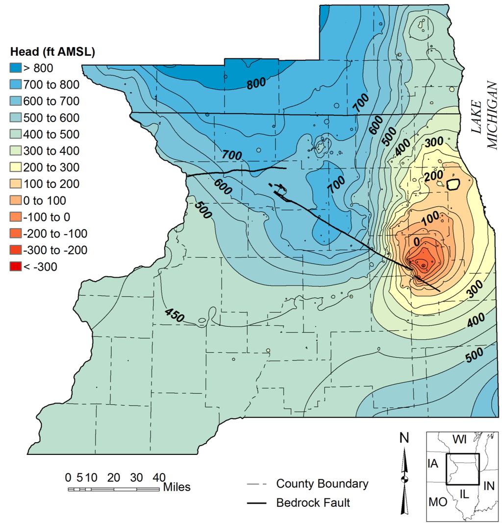
13 2014 Potentiometric Surface

14

15 Why have the decreases continued? 1. Withdrawal rates still above the capacity of the aquifer to transmit water from the west 2. The shale overlying the sandstones effectively shuts off local recharge 3. Newer wells are near the Sandwich Fault which acts as a flow barrier and magnifies drawdown 4. Newer wells completed only in the Ironton-Galesville which magnifies local drawdown 5. Dropping transmissivity as sandstone desaturates

16 KENDALL COUNTY, SANDWICH FAULT

17 Bedrock Units in Kendall County St Peter Sandstone Maquoketa Shale Silurian Dolomite Galena- Platteville Dolomite Pennsylvanian Shales

18 Water Level Elevations in the Deep Sandstone Aquifer

19 Sandwich Fault Elevation (ft asl) EAST-WEST CROSS SECTION ACROSS THE FAULT West Fox R. Potentiometric Surface of the Ancell Ancell Galena Platteville Well East Prairie du Chein Potosi - Franconia Ironton-Galesville Eau Claire Mt Simon

20 Observation well in Kendall County 1180 feet deep

21 Desaturation of sandstone aquifers

22 Desaturation before 1980 High capacity wells in use before 1980 were generally open to both the St. Peter and Ironton-Galesville Sandstones. The St. Peter Sandstone was at greatest risk of desaturation

23 Desaturation after 1980 Since 1980, most active wells have been cased through the Ironton- Galesville Sandstone, but the cross-connected wells are still present The St. Peter Sandstone is at greatest risk of desaturation


24 Observed risk of desaturation: 2014 : Observed head is less than 200 ft above the St. Peter : Observed head is ft below the top of the St. Peter : Observed head is more than 200 ft below the top of the St. Peter
25 DATA TRENDS IN THE JOLIET REGION (HEAD REMAINING ABOVE THE TOP OF THE IG) A new well field near the center of the cone of depression will accelerate the loss in available head
26 GROUNDWATER FLOW MODEL: TEST DIFFERENT PUMPING SCENARIOS Kendall County Joliet

27 Risk of desaturation: 2050 scenarios Uses a groundwater flow model designed to investigate the sandstone aquifers in Kendall and Will Counties (Roadcap et al. 2013)


28 2050 risk of desaturation scenarios: Both scenarios are possible Neither solves the problem alone
29 TWO METHODS FOR ESTIMATING WHEN THE IRONTON-GALESVILLE WILL START TO DESATURATE TRENDS IN WATER LEVELS <25 YEARS GROUNDWATER FLOW MODEL YEARS Actual time-frame will be shortened with the construction of new well fields
 Joliet (groundwater/kankakee River?")
30 Location of Future Water Demand Can we improve on the location of hypothetical wells by identifying lands annexed by municipalities? Who will expand in Kendall County? Oswego or Yorkville (groundwater/fox River?) Joliet (groundwater/kankakee River?) Plainfield (Lake Michigan)
31 Groundwater Flow and Ore Genesis

32 Distribution of Oil Reservoirs and Mature Devonian Source Rocks Bethke et al. (1991)

33 HERRIN COAL Groundwater issues: Brine disposal Strip mine reclamation Wetland restoration Acid mine drainage

34 Fracking for Natural Gas

35 Deep Waste Injection USEPA

36 Waste Injection Wells Salinity (mg/l) Fresh Depth ,900 2,700 34, , ,800 3,600 ISGS

37 Potential CO 2 Storage Reservoirs


38 Depth to the Top of the Mt Simon Thickness of the Mt Simon

39 CARBON SEQUESTRATION
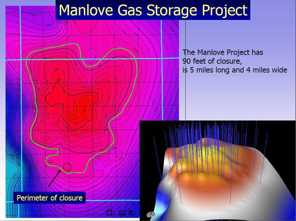
40 Manlove Natural Gas Storage Field Champaign County Wiki
41 ISGS
Changing Groundwater Levels in the Sandstone Aquifers of Northern Illinois and Southern Wisconsin: Impacts on Available Water Supply
 Contract Report 2015-02 Changing Groundwater Levels in the Sandstone Aquifers of Northern Illinois and Southern Wisconsin: Impacts on Available Water Supply Daniel B. Abrams, Daniel R. Hadley, Devin H.
Yields of Deep Sandstone Wells in Northern Illinois
 REPORT OF INVESTIGATION 43 Yields of Deep Sandstone Wells in Northern Illinois by W. C. WALTON and SANDOR CSALLANY Printed by authority of the State of Illinois STATE OF ILLINOIS HON. OTTO KERNER, Governor
Wisconsin s Hydrogeology: an overview
 2012 Soil and Water Conservation Society Conference Stevens Point, WI Feb 9, 2012 Wisconsin s Hydrogeology: an overview Ken Bradbury Wisconsin Geological and Natural History Survey University of Wisconsin-Extension
iii CONTENTS vii ACKNOWLEDGMENTS EXECUTIVE SUMMARY INTRODUCTION Study Area Data Sources Preparation of Geologic Maps
 CONTENTS ACKNOWLEDGMENTS EXECUTIVE SUMMARY INTRODUCTION Study Area Data Sources Preparation of Geologic Maps GEOLOGY Bedrock Geology Succession and Distribution Structural Features Description of Bedrock
Basin-Scale Hydrological Impact of Geologic Carbon Sequestration in the Illinois Basin: A Full-Scale Deployment Scenario
 Basin-Scale Hydrological Impact of Geologic Carbon Sequestration in the Illinois Basin: A Full-Scale Deployment Scenario Quanlin Zhou, Jens Birkholzer Earth Sciences Division Lawrence Berkeley National
How Can We Sustain Groundwater Quality in Karst and Fracturedcarbonate. Maureen A. Muldoon Geology Department Univ. Of Wisconsin-Oshkosh
 How Can We Sustain Groundwater Quality in Karst and Fracturedcarbonate Aquifers? Maureen A. Muldoon Geology Department Univ. Of Wisconsin-Oshkosh The Question Karst and fracturedcarbonates form productive,
Minewater Management Annual Meeting Marion, Illinois. August 13, 2013
 Minewater Management 2013 Annual Meeting Marion, Illinois August 13, 2013 Coal Mine Water Sources Water Sources Typical Surface Control Pond Typical Sand Pit Surface Sand Pit Control Ponds Public Review
Ground-Water Investigations for Siting the Superconducting Super Collider in Northeastern Illinois
 ISWS/CIR-170/88 Circular 170 STATE OF ILLINOIS DEPARTMENT OF ENERGY AND NATURAL RESOURCES Ground-Water Investigations for Siting the Superconducting Super Collider in Northeastern Illinois by ADRIAN P.
Source Sink Pipeline
 An Overview of Carbon Storage presented by Robert J. Finley Advanced Energy Technology Initiative Illinois State Geological Survey University of Illinois USA IEA Summer School Longyearbyen, Norway August,
Chapter 8 Fetter, Applied Hydrology 4 th Edition, Geology of Groundwater Occurrence
 Chapter 8 Fetter, Applied Hydrology 4 th Edition, 2001 Geology of Groundwater Occurrence Figure 8.42. Alluvial Valleys ground-water region. Fetter, Applied Hydrology 4 th Edition, 2001 Fetter, Applied
Groundwater in Bayfield County
 Groundwater in Bayfield County Presented to Bayfield County Large Scale Livestoc Study Committee April 23, 2015 Madeline Gotowitz Hydrogeologist Groundwater in Bayfield County Groundwater basics Hydrogeology
Geologic Mapping in Northeastern Illinois. What do we know about. Donald A. Keefer, Director Geologic Mapping and Hydrogeology Center
 Geologic Mapping in Northeastern Illinois & What do we know about Lake County s Geology? Donald A. Keefer, Director Geologic Mapping and Hydrogeology Center Societal Benefits of Mapping Water Supply Delineation,
An Assessment of Geological Carbon Sequestration in the Illinois Basin: The Illinois Basin-Decatur Site
 An Assessment of Geological Carbon Sequestration in the Illinois Basin: The Illinois Basin-Decatur Site presented by Robert J. Finley and the MGSC Project Team April 15, 2009 Illinois Sustainable Technology
Public Groundwater Supplies in Carroll County
 ??UL-60(28)/79??TIN 60-28?? OF ILLINOIS ILLINOIS INSTITUTE OF NATURAL RESOURCES Public Groundwater Supplies in Carroll County by Dorothy M. Woller and Ellis W. Sanderson ILLINOIS STATE WATER SURVEY URBANA
FRACTURE TRACES AND PRODUCTIVITY OF MUNICIPAL WELLS IN THE MADISON LIMESTONE, RAPID CITY, SOUTH DAKOTA
 Proceedings of the South Dakota Academy of Science, Vol. 87 (2008) 261 FRACTURE TRACES AND PRODUCTIVITY OF MUNICIPAL WELLS IN THE MADISON LIMESTONE, RAPID CITY, SOUTH DAKOTA Perry H. Rahn Department of
Soils, Hydrogeology, and Aquifer Properties. Philip B. Bedient 2006 Rice University
 Soils, Hydrogeology, and Aquifer Properties Philip B. Bedient 2006 Rice University Charbeneau, 2000. Basin Hydrologic Cycle Global Water Supply Distribution 3% of earth s water is fresh - 97% oceans 1%
A Comparison of Potentiometric Surfaces for the Cambrian-Ordovician Aquifers of Northeastern Illinois, 2000 and 2007
 Data/Case Study 2008-04 A Comparison of Potentiometric Surfaces for the Cambrian-Ordovician Aquifers of Northeastern Illinois, 2000 and 2007 by Stephen L. Burch Center for Groundwater Science December
WESTCARB Phase I Results Review
 WESTCARB Phase I Results Review Arizona Geologic Characterization Errol Montgomery Principal Errol L. Montgomery & Associates (520) 881-4912 emontgomery@elmontgomery.com November 9, 2005 Site Characterization
Basin-scale Modeling of CO 2 Sequestration in the Illinois Basin Status Report
 Basin-scale Modeling of CO 2 Sequestration in the Illinois Basin Status Report Edward Mehnert, James Damico, Scott Frailey, Hannes Leetaru, Yu-Feng Lin, Roland Okwen Illinois State Geological Survey, Prairie
Presented by: Peter J. Foster. Coauthors: James M. Emery Kenneth C. Hardcastle. Emery & Garrett Groundwater Investigations, LLC
 The Impacts of the Earthquake that Struck near Mineral Virginia on Groundwater Resources in Northern Virginia Presented by: Peter J. Foster Coauthors: James M. Emery Kenneth C. Hardcastle Introduction
Follow this and additional works at: Part of the Geology Commons
 Western Michigan University ScholarWorks at WMU Michigan Geological Repository for Research and Education Geosciences 2016 Geology of Michigan William B. Harrison III Michigan Geological Repository for
Groundwater Resources of Missouri. Cynthia Brookshire, R. G.
 Groundwater Resources of Missouri Cynthia Brookshire, R. G. GROUNDWATER... Water beneath the Earth s surface within a zone of saturation AQUIFER... A geologic formation or group of formations that are
Kane County Water Resources Investigations:
 Contract Report 2007-06 Kane County Water Resources Investigations: Final Report on Shallow Aquifer Potentiometric Surface Mapping Randall A. Locke II, P.G. and Scott C. Meyer, P.G. by Prepared for the
Water Framework Directive. Groundwater Monitoring Programme. Site Information. Kiltrough PWS
 Water Framework Directive Groundwater Monitoring Programme Site Information Kiltrough PWS ImagePath1: Kiltrough PWS\17_009_Kiltough_P1_SiteLo cation.jpg This monitoring point is a well that is part of
Finding Large Capacity Groundwater Supplies for Irrigation
 Finding Large Capacity Groundwater Supplies for Irrigation December 14, 2012 Presented by: Michael L. Chapman, Jr., PG Irrigation Well Site Evaluation Background Investigation Identify Hydrogeologic Conditions
THE MARCELLUS SHALE GAS PLAY Geology, Development, and Water-Resource Impact Mitigation
 THE MARCELLUS SHALE GAS PLAY Geology, Development, and Water-Resource Impact Mitigation John H. Williams New York Water Science Center Troy, New York https://profile.usgs.gov/jhwillia/ Marcellus shale
The Niagara Escarpment extends from western New York, through the GTA all the way up to Manitoulin Island and into Michigan and Wisconsin.
 is southern Ontario s most prominent topographic feature, extending more than 500 kilometres from western New York, through Niagara Falls and the western part of the Greater Toronto Area (GTA), and north
Three-Dimensional Geologic Model of the Pecatonica Gas Storage Field, Winnebago County, Illinois
 World Journal of Environmental Engineering, 2015, Vol. 3, No. 4, 121-125 Available online at http://pubs.sciepub.com/wjee/3/4/3 Science and Education Publishing DOI:10.12691/wjee-3-4-3 Three-Dimensional
How to Identify and Properly Classify Drill Cuttings
 How to Identify and Properly Classify Drill Cuttings (Creating Useful Borehole Logs) Dave Larson Hydrogeology and Geophysics Section Accurate information about the borehole location and a careful description
Seismic Data and Drilling in Hancock Co., Kentucky February 21, 2008
 Seismic Data and Drilling in Hancock Co., Kentucky February 21, 2008 J.A. Drahovzal 2/21/08 1 Hancock County (H1) Information Provided at 2/7/08 Meeting Depth of Top (t) and Thickness (th) in feet t Kn
THE MINISTRY OF ENERGY AND ENERGY INDUSTRIES MINERALS DIVISION MINE DESIGN TEMPLATE OPERATOR NAME: OPERATOR ADDRESS: PHONE NUMBER: FACSIMILE:
 THE MINISTRY OF ENERGY AND ENERGY INDUSTRIES MINERALS DIVISION MINE DESIGN TEMPLATE 1.0 GENERAL INFORMATION OPERATOR NAME: OPERATOR ADDRESS: PHONE NUMBER: FACSIMILE: NAME OF CONTACT: CELLULAR PHONE: EMAIL
OIL AND GAS PLAYS OF THE MICHIGAN BASIN, SOUTHERN ONTARIO. Terry Carter, Consulting Geologist London, Ontario
 OIL AND GAS PLAYS OF THE MICHIGAN BASIN, SOUTHERN ONTARIO Terry Carter, Consulting Geologist London, Ontario 1 Ontario Petroleum Industries Oil and Natural Gas 1250 oil wells, 1200 gas wells, annual production
Evolution of the conceptual hydrogeologic and ground-water flow model for Las Vegas Valley, Clark County, Nevada
 Evolution of the conceptual hydrogeologic and ground-water flow model for Las Vegas Valley, Clark County, Nevada Geological Society of America Annual Meeting November 14, 2 David J. Donovan Southern Nevada
SHALLOW GROUNDWATER RESOURCES
 3GS CONTRACT/GRANT REPORT: 1989-1 SHALLOW GROUNDWATER RESOURCES ASSESSMENT FOR THE VILLAGE OF MONTGOMERY, ILLINOIS Stephen S. McFadden, Craig R. Gendron, and Faith A. Stanke Technical Completion Report
Cappog Bridge (PW-3)
") Water Framework Directive Groundwater Monitoring Programme Site Information Cappog Bridge (PW-3) ImagePath1: Cappog Bridge\IEGBNI_NB_G_012_18_0 01_A_SiteLocation.jpg Cappog Bridge PW-3 is one of 8 boreholes
Water Framework Directive Groundwater Monitoring Programme Site Information Cappog Bridge (PW-3) ImagePath1: Cappog Bridge\IEGBNI_NB_G_012_18_0 01_A_SiteLocation.jpg Cappog Bridge PW-3 is one of 8 boreholes
Water Framework Directive. Groundwater Monitoring Programme. Site Information. Galbally
 Water Framework Directive Groundwater Monitoring Programme Site Information Galbally ImagePath1: Galbally\Galbally1.jpg Galbally source is comprised of 2 boreholes situated in Devonian Old Red Sandstones
Public Groundwater Supplies in Kane County
 sws B-60-22 Loan ISWS/BUL-60(22)/78 BULLETIN 60-22 STATE OF ILLINOIS DEPARTMENT OF REGISTRATION AND EDUCATION Public Groundwater Supplies in Kane County by DOROTHY M. WOLLER and ELLIS W. SANDERSON ILLINOIS
R ENW Services - Geophysics & GIS
 Yankton Block 1 Vermillion Block 2 N 2 0 1 Block 3 Elk Point 2 3 4 5 6 MILES Block 4 R20-2002-01 0 1 2 3 4 5 6 7 8 9 10 KILOMETERS Block 5 Figure courtesy of ENW Services - Geophysics & GIS Block 6 Test
Development and Implementation of a Monitoring Plan at a 1-million Tonne CCS Demonstration: Decatur, Illinois USA
 Development and Implementation of a Monitoring Plan at a 1-million Tonne CCS Demonstration: Decatur, Illinois USA Robert J. Finley, Principal Investigator Midwest Geological Sequestration Consortium Director,
IP 121 ILLINOIS PETROLEUJM Illinois Institute of Natdral Resources STATE GEOWGICA SURVEY DIVISION' Jack A. Simon. Chief
 IP 121 ILLINOIS PETROLEUJM 121 1981 Illinois Institute of Natdral Resources STATE GEOWGICA SURVEY DIVISION' Jack A. Simon. Chief Stevenson, D. L. (David L.) Geologic structure of the base of the New Albany
Land subsidence due to groundwater withdrawal in Hanoi, Vietnam
 Land Subsidence (Proceedings of the Fifth International Symposium on Land Subsidence, The Hague, October 1995). 1AHS Publ. no. 234, 1995. 55 Land subsidence due to groundwater withdrawal in Hanoi, Vietnam
TAMPA BAY TRIBUTARIES BASIN. Hydrogeological Setting
 TAMPA BAY TRIBUTARIES BASIN Hydrogeological Setting Aquifers within the Tampa Bay Tributaries Basins ground water flow system include the Floridan aquifer system, the intermediate aquifer system, and the
THE SANDWICH FAULT ZONE
 505 THE SANDWICH FAULT ZONE OF NORTHERN ILLINOIS Dennis R. Kolata T. C. Buschbach Janis D. Treworgy STATE OF ILLINOIS, DEPARTMENT OF REGISTRATION AND EDUCATION Illinois State Geological Survey, Urbana,
The Illinois Basin Decatur Project Decatur, Illinois USA: Overview and Impacts. Sallie E. Greenberg
 The Illinois Basin Decatur Project Decatur, Illinois USA: Overview and Impacts Sallie E. Greenberg Midwest Geological Sequestration Consortium SECARB Annual Meeting 12 March 2015 Acknowledgements The Midwest
Kentucky Geological Survey Marvin Blan #1 Hancock County, Kentucky Geologic Review. J. Richard Bowersox David A. Williams Kentucky Geological Survey
 Kentucky Geological Survey Marvin Blan #1 Hancock County, Kentucky Geologic Review J. Richard Bowersox David A. Williams Kentucky Geological Survey KYCCS Western Kentucky Project Review Lexington, Kentucky
Surface Processes Focus on Mass Wasting (Chapter 10)
") Surface Processes Focus on Mass Wasting (Chapter 10) 1. What is the distinction between weathering, mass wasting, and erosion? 2. What is the controlling force in mass wasting? What force provides resistance?
Surface Processes Focus on Mass Wasting (Chapter 10) 1. What is the distinction between weathering, mass wasting, and erosion? 2. What is the controlling force in mass wasting? What force provides resistance?
Chapter 14. Groundwater
 Chapter 14 Groundwater Importance of groundwater! Groundwater is water found in the pores of soil and sediment, plus narrow fractures in bedrock! Groundwater is the largest reservoir of fresh water that
Illinois Industrial Carbon Capture & Storage Project
 Illinois Industrial Carbon Capture & Storage Project Eliminating CO 2 Emissions from the Production of Bio Fuels - A Green Carbon Process IEA Bio-CCUS Workshop May 10, 2016 Scott McDonald Biofuels Development
NEAR THE VILLAGE OF NORTH AURORA, ILLINOIS RESULTS OF A SHALLOW SEISMIC REFRACTION SURVEY. Timothy H. Larson. QsuJk Sa^^oJ^M. Philip G.
 557 IL6of 1991-15 QsuJk Sa^^oJ^M RESULTS OF A SHALLOW SEISMIC REFRACTION SURVEY NEAR THE VILLAGE OF NORTH AURORA, ILLINOIS Timothy H. Larson Philip G. Orozco Open File Series 1991-15 ILLINOIS STATE GEOLOGICAL
Essentials of Geology, 11e
 Essentials of Geology, 11e Groundwater Chapter 10 Instructor Jennifer Barson Spokane Falls Community College Geology 101 Stanley Hatfield Southwestern Illinois Co Jennifer Cole Northeastern University
A surficial. P^HiHI waste disposal site, Bureau County, Illinois. east of the Sheffield low-level radioactive. electrical resistivity survey
 ISGS CONTRACT/GRANT REPORT 1981-6 WATER RESOURCES DIVISION/USGS P^HiHI 100240 557.09773 IL6cr 1981-6 A surficial electrical resistivity survey east of the Sheffield low-level radioactive waste disposal
Hydrogeology of Karst NE Wisconsin. Dr. Maureen A. Muldoon UW-Oshkosh Geology Department
 Hydrogeology of Karst NE Wisconsin Dr. Maureen A. Muldoon UW-Oshkosh Geology Department WI Bedrock Outline Karst Landscapes Existing WQ Data Flow in Karst Aquifers Overview of Silurian Aquifer Water Level
Seminary Fen Phase 2 Hydrologic Study and Hydrologic Assessment of Alternative Corridors TH 41 Tier 1 DEIS Study
 Seminary Fen Phase 2 Hydrologic Study and Hydrologic Assessment of Alternative Corridors TH 41 Tier 1 DEIS Study Prepared for SRF Consulting Group Minnesota Department of Transportation June 2007 4700
Illinois Drought Update, December 1, 2005 DROUGHT RESPONSE TASK FORCE Illinois State Water Survey, Department of Natural Resources
 Illinois Drought Update, December 1, 2005 DROUGHT RESPONSE TASK FORCE Illinois State Water Survey, Department of Natural Resources For more drought information please go to http://www.sws.uiuc.edu/. SUMMARY.
Hydraulic and Water-Quality Characterization of Fractured-Rock Aquifers Using Borehole Geophysics
 Hydraulic and Water-Quality Characterization of Fractured-Rock Aquifers Using Borehole Geophysics John H. Williams Office of Ground Water Troy, New York Flow in Open Borehole Runkel and others (2003) Ambient
Groundwater Hydrology
 EXERCISE 12 Groundwater Hydrology INTRODUCTION Groundwater is an important component of the hydrologic cycle. It feeds lakes, rivers, wetlands, and reservoirs; it supplies water for domestic, municipal,
Senior Thesis. BY Calliope A. Voiklis 2000
 Senior Thesis MODFLOW Model of The Ohio State University, Columbus Campus BY Calliope A. Voiklis 2000 Submitted as partial fulfillment of The requirements of the degree of Bachelor of Science in Geological
Where to Drill in Western Kentucky February
 Where to Drill in Western Kentucky? February 7. 2008 J.A. Drahovzal 2/7/08 Assumptions to Date and Questions Drill no more than 8,000 feet Drill multi-horizons (at least 2 major horizons) Do we want to
RECOVERY OF GROUNDWATER LEVELS AFTER LONGWALL MINING
 MINE, WATER & ENVIRONMENT. 1999 IMWA Congress. Sevilla, Spain RECOVERY OF GROUNDWATER LEVELS AFTER LONGWALL MINING Colin J. Booth Northern Illinois University, Department of Geology & Environmental Geosciences
Western Kentucky Deep Saline Reservoir CO 2 Storage Test. Principal Investigators: J. Richard Bowersox - Lexington David A. Williams - Henderson
 Western Kentucky Deep Saline Reservoir CO 2 Storage Test Principal Investigators: J. Richard Bowersox - Lexington David A. Williams - Henderson August 12, 2008 Electric power generating and industrial
Is It Likely That Fracking the Organic-Rich Utica Shale Beneath Bowling Green, OH Would Be Environmentally Safe?
 Is It Likely That Fracking the Organic-Rich Utica Shale Beneath Bowling Green, OH Would Be Environmentally Safe? Dr. Robert K. Vincent Prof. Emeritus, Dept. of Geology Bowling Green State University How
SEASONAL WATER STORAGE AND REPLENISHMENT OF A FRACTURED GRANITE AQUIFER USING ASR WELLS
 SEASONAL WATER STORAGE AND REPLENISHMENT OF A FRACTURED GRANITE AQUIFER USING ASR WELLS Mario R. Lluria; Phillip M. Paski; Gary G. Small HydroSystems, Incorporated Phoenix, Arizona USA Presentation Contents
Western Kentucky CO 2 Storage Test
 Western Kentucky CO 2 Storage Test Principal Investigators: Rick Bowersox - Lexington Dave Williams - Henderson KGS First Friday Seminar Lexington, Kentucky March 4, 2011 The project proceeded in two phases:
Differentiation of chloride source using stable chlorine isotopes
 Differentiation of chloride source using stable chlorine isotopes RemTech 2009 Banff, Alberta October 14-16 2009 Dr. Alec Blyth and Tom Anthony 1 1 currently City of Calgary Background: DOW Chemical Canada
Green River Lowland and
 EG 149 14.GS: EGN 149 c. 3 (X^JL^uu^-j Hydrogeology of the Green River Lowland and Associated Bedrock Valleys in Northwestern Illinois David R. Larson Beverly L. Herzog Robert C. Vaiden Cheri A. Chenoweth
An Overview of Carbon Sequestration in Pennsylvania. John A. Harper Pennsylvania Geological Survey
 An Overview of Carbon Sequestration in Pennsylvania John A. Harper Pennsylvania Geological Survey Are you sure you re comfortable? Let s dive right in! Principal Global CO2 Sequestration Targets Terrestrial
Groundwater Monitoring & Aggregate Operations in the Villeneuve-Calahoo Area. William Gowdy, BSc. P.Geo
 Groundwater Monitoring & Aggregate Operations in the Villeneuve-Calahoo Area William Gowdy, BSc. P.Geo Format of Talk General Background Sand and Gravel Geology & Formation of Sand and Gravel Deposits
Western Kentucky Deep Saline Reservoir CO 2 Storage Test. Principal Investigators: J. Richard Bowersox - Lexington David A. Williams - Henderson
 Western Kentucky Deep Saline Reservoir CO 2 Storage Test Principal Investigators: J. Richard Bowersox - Lexington David A. Williams - Henderson October 2, 2008 Electric power generating and industrial
Delineating and Assessing Saline Ground Water Resources
 Delineating and Assessing Saline Ground Water Resources USGS Water Science Centers Arkansas Georgia OklahomA Sulfur water at Chickasaw National Recreation Area Sulphur, Oklahoma Background and Problem
, ucvjl JUN ourtvey
 LIBRARY. , ucvjl JUN 1 2 1997 ourtvey Digitized by the Internet Archive in 2012 with funding from University of Illinois Urbana-Champaign http://archive.org/details/seismicreflectio136heig i l.gs EN 136
Ground Water in the Piedmont and Blue Ridge
 engineering earth's development preserving earth's integrity Engineering Earth s Development Preserving Earth s Integrity Ground Water in the Piedmont and Blue Ridge Jim Renner Acknowledgements Contributors:
Geological Survey of Alabama Groundwater Assessment Program
 Geological Survey of Alabama Groundwater Assessment Program Hydrogeologic Characterization and Groundwater Source Development Assessment for Area 2, Southwestern Alabama Gheorghe M. Ponta, Marlon R. Cook,
Antelope Hills Directionally Drilled Water Well. Theresa Jehn-Dellaport Jehn Water Consultants, Inc.
 Antelope Hills Directionally Drilled Water Well Theresa Jehn-Dellaport Directional Well Applications Deep Bedrock Aquifers Proven Oil field technology Initial Analysis indicates up to 4 times the production
Western Kentucky Deep Saline Reservoir CO 2 Storage Test. Principal Investigators: J. Richard Bowersox - Lexington David A. Williams - Henderson
 Western Kentucky Deep Saline Reservoir CO 2 Storage Test Principal Investigators: J. Richard Bowersox - Lexington David A. Williams - Henderson July 22, 2008 Electric power generating and industrial plants
MESOZOIC BASINS. North Carolina Geological Survey
 MESOZOIC BASINS North Carolina Geological Survey The 1823 organic act which created the North Carolina Geological Survey (NCGS) tasked us to examine, describe and map the geology, geologic hazards, and
Public Groundwater Supplies in Boone County
 OFFICE COPY ISWS-74-BUL60(6) BULLETIN 60-6 STATE OF ILLINOIS DEPARTMENT OF REGISTRATION AND EDUCATION Public Groundwater Supplies in Boone County by DOROTHY M. WOLLER and ELLIS W. SANDERSON ILLINOIS STATE
THIS IS A NEW SPECIFICATION
 THIS IS A NEW SPECIFICATION ADVANCED GCE GEOLOGY Environmental Geology F794 * OCE / 12353* Candidates answer on the Question Paper OCR Supplied Materials: None Other Materials Required: Ruler (cm/mm) Thursday
Oola PWS - Carrigmore BH
 Water Framework Directive Groundwater Monitoring Programme Site Information Oola PWS - Carrigmore BH ImagePath1: Oola PWS - Carrigmore BH\OolaPWSCarrigmore1.jpg Oola PWS Carrigmore BH is a borehole used
Geologic Considerations of Shallow SAGD Caprock; Seal Capacity, Seal Geometry and Seal Integrity, Athabasca Oilsands, Alberta Canada
 Geologic Considerations of Shallow SAGD Caprock; Seal Capacity, Seal Geometry and Seal Integrity, Athabasca Oilsands, Alberta Canada Gordon T. Stabb, Michael Webb Durando Resources Corp, Suncor Energy
Surficial Geologic Mapping Proposal for STATEMAP FY2019
 Surficial Geologic Mapping Proposal for STATEMAP FY2019 presented by David Grimley Illinois State Geological Survey Prairie Research Institute, University of Illinois IGMAC meeting, September 6 th, 2018
Simulation of Ground-Water Flow in the Cedar River Alluvial Aquifer Flow System, Cedar Rapids, Iowa
 Prepared in cooperation with the City of Cedar Rapids Simulation of Ground-Water Flow in the Cedar River Alluvial Aquifer Flow System, Cedar Rapids, Iowa Scientific Investigations Report 2004-5130 U.S.
Dunkerrin - Guilfoyles Well
 Water Framework Directive Groundwater Monitoring Programme Site Information Dunkerrin - Guilfoyles Well ImagePath1: Dunkerrin - Guilfoyles Well\IE_SH_G_19_005_a_Pump House_(800_x_600).jpg Dunkerrin/ Guilfoyles
A Standardized Digital Well-Record Database for the Glaciated U.S.
 A Standardized Digital Well-Record Database for the Glaciated U.S. Randy Bayless and Les Arihood U.S. Geological Survey, Indiana Water Science Center, Indianapolis, IN Howard Reeves U.S. Geological Survey,
Meeting the Growing Demand for Water:
 ISWS RR 123 copy 1 loan Report 123 Meeting the Growing Demand for Water: An Evaluation of the Shallow Ground-Water Resources in Will and Southern Cook Counties, Illinois by George S. Roadcap, Stuart J.
Public Groundwater Supplies in Stephenson County
 ISWS/BUL-60(30)/84 BULLETIN 60-30 STATE OF ILLINOIS DEPARTMENT OF ENERGY AND NATURAL RESOURCES Public Groundwater Supplies in Stephenson County by DOROTHY M. WOLLER, KAREN L. KUNZ, and ELLIS W. SANDERSON
Catalog of cores from the sub-galena Group in Illinois
 -\ Catalog of cores from the sub-galena Group in Illinois Thomas H. Shaw Michael L. Sargent ILLINOIS PETROLEUM 132 Department of Energy and Natural Resources ILLINOIS STATE GEOLOGICAL SURVEY ILLINOIS STATE
Public Groundwater Supplies in Lake County
 ISWS/BUL-601201/76 BULLETIN 60-20 STATE OF ILLINOIS DEPARTMENT OF REGISTRATION AND EDUCATION Public Groundwater Supplies in Lake County by DOROTHY M. WOLLER and JAMES P. GIBB ILLINOIS STATE WATER SURVEY
Larson, David R. GEOLOGIC, GEOPHYSICAL, AND HYDROLOGIC INVESTIGATIONS FOR A SUPPLEMENTAL MUNICIPAL GROUNDWATER SUPPLY,
 ISWS COOP18 Loan c.1 98062215 Larson, David R. GEOLOGIC, GEOPHYSICAL, AND HYDROLOGIC INVESTIGATIONS FOR A SUPPLEMENTAL MUNICIPAL GROUNDWATER SUPPLY, ISWS COOP18 Loan c.1 98062215 Larson, David R. GEOLOGIC,
Tuesday 6 June 2017 Afternoon
 Oxford Cambridge and RSA Tuesday 6 June 2017 Afternoon A2 GCE GEOLOGY F794/01 Environmental Geology *6783378785* Candidates answer on the Question Paper. OCR supplied materials: None Other materials required:
CK-UNIT MAPPING OF GEOLOGIC MATERIALS IN ILLINOIS TO A DEPTH OF 15 METERS
 s 14.GS: CIR 542 c.4 - CK-UNIT MAPPING OF GEOLOGIC MATERIALS IN ILLINOIS TO A DEPTH OF 15 METERS llun.ots GEOLOGICAL survey LIBRARY r Richard C. Berg and John P. Kempton ILLINOIS STATE GEOLOGICAL SURVEY
J.H. Campbell Generating Facility Pond A - Location Restriction Certification Report
 J.H. Campbell Generating Facility Pond A - Location Restriction Certification Report Pursuant to: 40 CFR 257.60 40 CFR 257.61 40 CFR 257.62 40 CFR 257.63 40 CFR 257.64 Submitted to: Consumers Energy Company
Time Domain Electromagnetic Induction Survey Of Eastern Waukesha County And Selected Locations. Waukesha County, Wisconsin
 Time Domain Electromagnetic Induction Survey Of Eastern Waukesha County And Selected Locations John Jansen, Senior Geoscientist, Aquifer Science and Technology Robert Taylor, Associate Professor, Department
STATE GEOLOGICAL SURVEY M. M. LEIGHTON, Chief
 ' ' ' WBm ill ,." STATE OF ILLINOIS HENRY HORNER, Governor DEPARTMENT OF REGISTRATION AND EDUCATION JOHN J. HALLIHAN, Director DIVISION OF THE STATE GEOLOGICAL SURVEY M. M. LEIGHTON, Chief URBANA CIRCULAR
WELL PLUGGING PROCEDURES
 PUBLIC INFORMATION CIRCULAR JULY 1971 NUMBER I OPTIMAL WELL PLUGGING PROCEDURES BY ORVILLE J VAN ECK IOWA GEOLOGICAL SURVEY SAMUEL J. TUTHILL, State Geologist Iowa City OPTIMAL WELL PLUGGING PROCEDURES
Midwest Regional Carbon Sequestration Partnership (MRCSP) Press Briefing. February 21, 2008
 Press Briefing. February 21, 2008") Midwest Regional Carbon Sequestration Partnership (MRCSP) Michigan Basin Test Site Press Briefing Introduction and Overview: Abed Houssari, DTE Energy DOE s Sequestration Program: Lynn Brickett, US DOE/NETL
Midwest Regional Carbon Sequestration Partnership (MRCSP) Michigan Basin Test Site Press Briefing Introduction and Overview: Abed Houssari, DTE Energy DOE s Sequestration Program: Lynn Brickett, US DOE/NETL
Water Framework Directive. Groundwater Monitoring Programme. Site Information. Drum Bingahamstown
 Water Framework Directive Groundwater Monitoring Programme Site Information Drum Bingahamstown ImagePath1: Drum Bingahamstown\IE_WE_G_16_ 1_a_Spring.jpg Drum Binghamstown is a spring that is used for a
Groundwater Geology of DeKalb County, Illinois with Emphasis on the Troy Bedrock Valley
 C 563 Groundwater Geology of DeKalb County, Illinois with Emphasis on the Troy Bedrock Valley Robert C. Vaiden, Edward C. Smith, and Timothy H. Larson Circular 563 4 Illinois Department of Natural Resources
S^aaav. DOE Award Number: DE-FG26-99FT E. Peabody Dr. Champaign, IL Champaign, IL Reservoir Characterization & 3D Models
 557 IL6of 2002-1 ^M S^aaav Reservoir Characterization & 3D Models of Mt Simon Gas Storage Fields in the Illinois Basin Annual Technical Progress Report Reporting Period Start Date: October 1, 2000 Reporting
Practice Test Rocks and Minerals. Name. Page 1
 Name Practice Test Rocks and Minerals 1. Which rock would be the best source of the mineral garnet? A) basalt B) limestone C) schist D) slate 2. Which mineral is mined for its iron content? A) hematite
Mapping groundwater conditions of deep saline formations in West-Central Alberta
 Mapping groundwater conditions of deep saline formations in West-Central Alberta Nevenka Nakevska, Jordan Brinsky, Amandeep Singh WaterTech 2017, April 3-5, Banff Area of Interest Grande Prairie Swan Hills