Kentucky Geological Survey Marvin Blan #1 Hancock County, Kentucky Geologic Review. J. Richard Bowersox David A. Williams Kentucky Geological Survey
|
|
|
- Ira Hawkins
- 5 years ago
- Views:
Transcription


1 Kentucky Geological Survey Marvin Blan #1 Hancock County, Kentucky Geologic Review J. Richard Bowersox David A. Williams Kentucky Geological Survey KYCCS Western Kentucky Project Review Lexington, Kentucky October 23, 2009

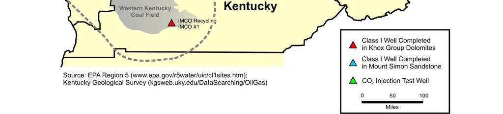
2 Regional Injection Wells


3 Project Goals Demonstrate and characterize the potential for the geologic storage of CO 2 in western Kentucky Target reservoir is the Knox Dolomite Found 3617 ft of Knox Dolomite, including Gunter Sandstone Average porosity 6.7% calculated from logs Successfully injected 18,454 BW brine and 323 T CO 2 Evaluate St Peter and Mount Simon Sandstones, if present Test the reservoir potential of the Precambrian Middle Run Sandstone Characterize the reservoir sealing properties of the New Albany Shale, Maquoketa Shale, Black River Group, and non-reservoir intervals in the Knox


4

 Maquoketa Shale (31 ft)")
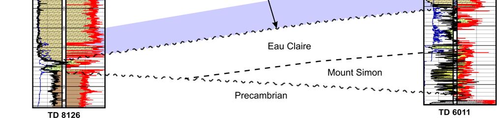
 Precambrian Middle Run Sandstone (30 ft) Reached TD at 8126 ft on")
5 Drilling Marvin Blan #1 Drilling commenced on April 24, 2009 Casing cemented at 3660 ft, open hole below to TD Drilled through the Knox Group using CaCO 3 -based mud to mitigate potential reservoir damage Seven cores cut to test reservoir and seal properties Reservoir seals New Albany Shale (30 ft) Maquoketa Shale (31 ft) Black River Limestone (61 ft) CO 2 storage reservoirs Knox Group (three cores, 243 ft total) Precambrian Middle Run Sandstone (30 ft) Reached TD at 8126 ft on June 14


6 Drilling Results St Peter Sandstone effectively absent: only six inches of sand was present at the Knox unconformity The Knox Group was found 85 ft structurally higher than expected and 380 ft thinner Eau Claire was considerably thinner than expected, only 187 ft thick including a 61 ft dolomite bed Top of the Precambrian Middle Run Sandstone was found 420 ft higher than expected

7 Strata penetrated in the Marvin Blan #1.


8 Maquoketa Shale Core Maquoketa Shale was cored ft to test its reservoir seal properties Analyses of seal properties Threshold entry pressure XRD mineralogy Thin section petrography Mechanical properties
 Unconformity Knox")
9 St. Peter Sandstone (6 inches) Epikarst infilled with sandstone (3 inches) Unconformity Knox Dolomite

10 Structural contours on top of the Knox Group.


11 Stratigraphic correlation of the Knox Group and deeper strata.
 to test reservoir properties")
 Copper Ridge (19 ft) Found porosity system to be a")


12 Knox Dolomite Cores Knox Dolomite was cored in three intervals (total 243 ft) to test reservoir properties St Peter -Beekmantown (123 ft) Beekmantown-Gunter (101 ft) Copper Ridge (19 ft) Found porosity system to be a complex of preserved fabric, primary dolomite porosity, vugs, and fractures Extensive analysis program Routine core analysis Mechanical properties XRD mineralogy CO 2 core flood Thin section petrography Threshold entry pressure


13 5098 CMI log section and core showing vuggy porosity in the Beekmantown Dolomite


14 Knox Reservoir Properties Average Porosity 6.7% NNW Fracture Trend

15 Potential Reservoir Volume in the Knox Base: all data Cutoff cases: 1. caliper > 10½ in. 2. porosity > 20% 3. porosity < 5% 4. porosity < 6% 5. porosity < 7% 6. porosity <8% 7. porosity < 9% 8. porosity < 10%


16 Middle Run Sandstone Core Precambrian Middle Run Sandstone was cored ft to evaluate its potential as a carbon storage reservoir DOE-NETL grant for coring and analysis Analysis Program Routine core analysis Fracture orientation XRD mineralogy Thin section petrography Provenance Zircon age dating Mechanical properties


17 Drilling Challenges Drilling rig and wellhead mechanical failures Lower than expected penetration rates Borehole deviation below 3000 ft Angle built to 5.75 Used Schlumberger Vertical Seeking Power V System to bring borehole back to vertical Lost circulation thief zone at 5581 ft Successfully controlled with LCM Drilled ~250 ft deeper than necessary to achieve objectives due to missed formation tops Added two days to drilling

18 Marvin Blan #1 Depth vs. Days Drilling took 62 days, 13 days longer than planned, despite a shallower than planned TD.


19 Injection Testing Beekmantown Gunter Copper Ridge Eau Claire Middle Run Three tests with straddle packers basal Copper Ridge: BW, broke down at 0.9 psi/ft gradient and took water on vacuum upper Copper Ridge: two tests, total BW, lost seal due to communication through formation porosity system around packers Two tests with single packer Copper Ridge below 6089 ft: 2190 BW brine, BW with borax tracer Full wellbore below 3620 ft: BW with borax tracer Injection rates to 14 BPM at psi wellhead pressure Found 70% of water was injected above the Copper Ridge
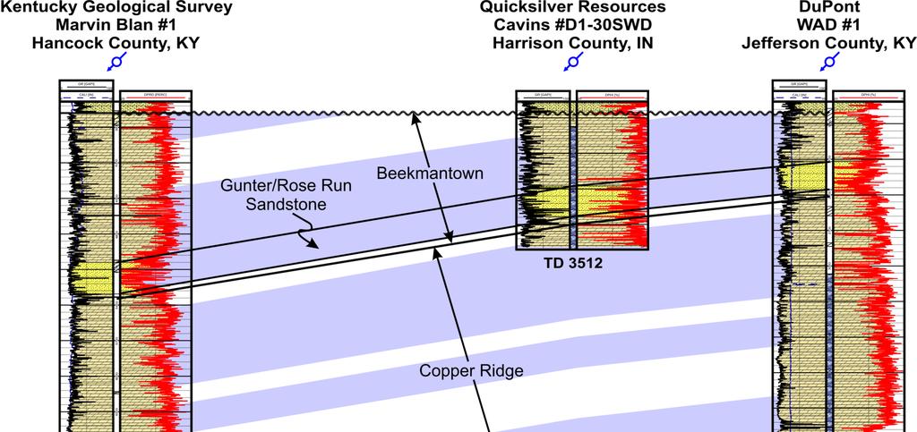
20 Regional correlation of Knox injection zones
 below a packer")


21 CO 2 Injection Injected a total of 323 Tons of CO 2 (1765 bbl or 5646 mcfg) below a packer set in casing at 3603 ft Limited to 4.1 BPM rate due to pump limitations Wellhead pressure 936 psi, bottomhole pressure 1754 psi Post-injection flushed with 4568 BW brine Long-term downhole pressure gauge in place to monitor pressure fall-off pending re-entry for additional tests


22 Additional Work Testing planned for 2010, funded by DOE research award of $1.6 million Additional brine, possibly additional CO 2 injection 3D VSP to image injection plume Knox reservoir evaluation Plug and abandon the Marvin Blan #1 in compliance with State and EPA regulations Remediate drillsite Groundwater and soil gas monitoring through 2012


23 Acknowledgements This research is being supported by a grant from the Commonwealth of Kentucky with additional contributions by the Energy and Environment Cabinet, the University of Kentucky, and a consortium of more than twenty industry partners. Principal contributors include: Western Kentucky Carbon Storage Foundation ConocoPhillips Company Peabody Energy E.ON U.S. T.V.A. Illinois Office of Coal Development US DOE-NETL GEO Consultants, LLC Schlumberger Carbon Services Smith Management Company Wyatt, Tarrant & Combs, LLP
24
Western Kentucky CO 2 Storage Test
 Western Kentucky CO 2 Storage Test Principal Investigators: Rick Bowersox - Lexington Dave Williams - Henderson KGS First Friday Seminar Lexington, Kentucky March 4, 2011 The project proceeded in two phases:
Western Kentucky Deep Saline Reservoir CO 2 Storage Test. Principal Investigators: J. Richard Bowersox - Lexington David A. Williams - Henderson
 Western Kentucky Deep Saline Reservoir CO 2 Storage Test Principal Investigators: J. Richard Bowersox - Lexington David A. Williams - Henderson August 12, 2008 Electric power generating and industrial
Western Kentucky Deep Saline Reservoir CO 2 Storage Test. Principal Investigators: J. Richard Bowersox - Lexington David A. Williams - Henderson
 Western Kentucky Deep Saline Reservoir CO 2 Storage Test Principal Investigators: J. Richard Bowersox - Lexington David A. Williams - Henderson July 22, 2008 Electric power generating and industrial plants
Western Kentucky Deep Saline Reservoir CO 2 Storage Test. Principal Investigators: J. Richard Bowersox - Lexington David A. Williams - Henderson
 Western Kentucky Deep Saline Reservoir CO 2 Storage Test Principal Investigators: J. Richard Bowersox - Lexington David A. Williams - Henderson October 2, 2008 Electric power generating and industrial
CO 2 Storage Potential in the Mt Simon Sandstone, Western Kentucky. Rick Bowersox January 22, 2008
 CO 2 Storage Potential in the Mt Simon Sandstone, Western Kentucky Rick Bowersox January 22, 2008 Presentation Outline Overview of Western Kentucky geology Review of CO 2 storage reservoir issues in western
Seismic Data and Drilling in Hancock Co., Kentucky February 21, 2008
 Seismic Data and Drilling in Hancock Co., Kentucky February 21, 2008 J.A. Drahovzal 2/21/08 1 Hancock County (H1) Information Provided at 2/7/08 Meeting Depth of Top (t) and Thickness (th) in feet t Kn
The Illinois Basin Decatur Project Decatur, Illinois USA: Overview and Impacts. Sallie E. Greenberg
 The Illinois Basin Decatur Project Decatur, Illinois USA: Overview and Impacts Sallie E. Greenberg Midwest Geological Sequestration Consortium SECARB Annual Meeting 12 March 2015 Acknowledgements The Midwest
Geology of the Kentucky Geological Survey Marvin Blan No. 1 Well, East-Central Hancock County, Kentucky
 University of Kentucky UKnowledge Kentucky Geological Survey Report of Investigations Kentucky Geological Survey 2014 Geology of the Kentucky Geological Survey Marvin Blan No. 1 Well, East-Central Hancock
Where to Drill in Western Kentucky February
 Where to Drill in Western Kentucky? February 7. 2008 J.A. Drahovzal 2/7/08 Assumptions to Date and Questions Drill no more than 8,000 feet Drill multi-horizons (at least 2 major horizons) Do we want to
Source Sink Pipeline
 An Overview of Carbon Storage presented by Robert J. Finley Advanced Energy Technology Initiative Illinois State Geological Survey University of Illinois USA IEA Summer School Longyearbyen, Norway August,
Geologic and Reservoir Characterization and Modeling
 Geologic and Reservoir Characterization and Modeling Scott M. Frailey and James Damico Illinois State Geological Survey Midwest Geologic Sequestration Science Conference November 8 th, 2011 Acknowledgements
An Assessment of Geological Carbon Sequestration in the Illinois Basin: The Illinois Basin-Decatur Site
 An Assessment of Geological Carbon Sequestration in the Illinois Basin: The Illinois Basin-Decatur Site presented by Robert J. Finley and the MGSC Project Team April 15, 2009 Illinois Sustainable Technology
Seismic-Data Interpretations near the Blan Carbon Sequestration Test Well in Hancock Co., Kentucky
 Seismic-Data Interpretations near the Blan Carbon Sequestration Test Well in Hancock Co., Kentucky KYCCS Western Kentucky Deep Test Review Meeting Friday, October 23, 2009 James A. Drahovzal Consulting
Illinois Industrial Carbon Capture & Storage Project
 Illinois Industrial Carbon Capture & Storage Project Eliminating CO 2 Emissions from the Production of Bio Fuels - A Green Carbon Process IEA Bio-CCUS Workshop May 10, 2016 Scott McDonald Biofuels Development
Development and Implementation of a Monitoring Plan at a 1-million Tonne CCS Demonstration: Decatur, Illinois USA
 Development and Implementation of a Monitoring Plan at a 1-million Tonne CCS Demonstration: Decatur, Illinois USA Robert J. Finley, Principal Investigator Midwest Geological Sequestration Consortium Director,
Basin-Scale Hydrological Impact of Geologic Carbon Sequestration in the Illinois Basin: A Full-Scale Deployment Scenario
 Basin-Scale Hydrological Impact of Geologic Carbon Sequestration in the Illinois Basin: A Full-Scale Deployment Scenario Quanlin Zhou, Jens Birkholzer Earth Sciences Division Lawrence Berkeley National
Assessment of CO 2 Enhanced Gas Recovery in Shale Gas Reservoirs (Preliminary)*
*") Assessment of CO 2 Enhanced Gas Recovery in Shale Gas Reservoirs (Preliminary)* Brandon C. Nuttall 1, Michael L. Godec 2, Robert J. Butsch 3, and David E. Riestenberg 4 Search and Discovery Article #80296
Assessment of CO 2 Enhanced Gas Recovery in Shale Gas Reservoirs (Preliminary)* Brandon C. Nuttall 1, Michael L. Godec 2, Robert J. Butsch 3, and David E. Riestenberg 4 Search and Discovery Article #80296
East Bend Test Site Core Team
 MRCSP Cincinnati Arch-East Bend Site Geologic Field Test in Mt. Simon Sandstone EPA Region 5 Regional Carbon Sequestration Meeting March 21-22, 2007, Pokagon State Park, Indiana East Bend Test Site Core
Minewater Management Annual Meeting Marion, Illinois. August 13, 2013
 Minewater Management 2013 Annual Meeting Marion, Illinois August 13, 2013 Coal Mine Water Sources Water Sources Typical Surface Control Pond Typical Sand Pit Surface Sand Pit Control Ponds Public Review
The Impacts of Carbon Dioxide Storage in the Saline Arbuckle Aquifer on Water Quality in Freshwater Aquifers in Kansas
 The Impacts of Carbon Dioxide Storage in the Saline Arbuckle Aquifer on Water Quality in Freshwater Aquifers in Kansas Tiraz Birdie, Lynn Watney, Paul Gerlach, Michael Killion, Jennifer Raney, Eugene Holubnyak,
2 OVERVIEW OF SHALLOW BOREHOLE INVESTIGATIONS
 2 OVERVIEW OF SHALLOW BOREHOLE INVESTIGATIONS Preparation for MSB-2 started in April 2002. Drilling and planned field work in both MSB-2 and 4 were carried out at the same time. After completion of the
By: Jared T. Freiburg Illinois State Geological Survey 5/17/ cm
 Current Research on the Mt. Simon Geology; Refining the Lower Mt. Simon Depositional Interpretation By: Jared T. Freiburg Illinois State Geological Survey freiburg@illinois.edu 5/17/2016 2.5 cm Collaborators
ADM CCS Projects Experience and Lessons Learned
 ADM CCS Projects Experience and Lessons Learned CSLF Technical Workshop June 17, 2015 Scott McDonald Biofuels Development Director scott.mcdonald@adm.com Acknowledgements The Industrial Carbon Capture
region includes nine states and four provinces, covering over 1.4 million square miles. The PCOR Partnership
 Overview of Phase II PCOR Partnership MVA Activities IEAGHG Monitoring Network Meeting Natchez, MS May 6-8, 2010 Steven A. Smith, Energy & Environmental Research Center The Plains CO 2 Reduction (PCOR)
Colorado s Underground Injection Control Program: Prevention and Mitigation of Induced Seismicity
 Colorado s Underground Injection Control Program: Prevention and Mitigation of Induced Seismicity Energy & Environment Symposium April 2015 Robert P. Koehler, PhD. UIC Lead OVERVIEW What is a UIC well?
StackFRAC HD system outperforms cased hole in vertical wells
 Case Study StackFRAC HD system outperforms cased hole in vertical wells UNITED STATES, PERMIAN BASIN STACKFRAC HD SYSTEM Background The Permian Basin consists of several stacked pay zones and is one of
PART I Hot Dry Rock Geothermal Energy: History and Potential of the Newest and Largest Renewable Energy Resource
 Contents PART I Hot Dry Rock Geothermal Energy: History and Potential of the Newest and Largest Renewable Energy Resource Chapter 1 Serendipity A Brief History of Events Leading to the Hot Dry Rock Geothermal
Introduction to Formation Evaluation Abiodun Matthew Amao
 Introduction to Formation Evaluation By Abiodun Matthew Amao Monday, September 09, 2013 Well Logging PGE 492 1 Lecture Outline What is formation evaluation? Why do we evaluate formation? What do we evaluate?
Technology of Production from Shale
 Technology of Production from Shale Doug Bentley, European Unconventional, Schlumberger May 29 th, 2012 Johannesburg, South Africa What are Unconventional Reservoirs Shale both Gas & Oil Coal Bed Methane
West Coast Research. WESTCARB Technical Director California Energy Commission
 Field Experience from West Coast Research Larry Myer WESTCARB Technical Director California Energy Commission lrmyer@lbl.gov Carbon Capture & Sequestration Public Workshop Bakersfield, CA September 25,
ILLINOIS GROUNDWATER - BEDROCK
 ILLINOIS GROUNDWATER - BEDROCK Northern Illinois Fresh Water Water Supply Shallow Bedrock Aquifers < 500 depth Deep Bedrock Aquifers > 500 depth Southern Illinois Saline water Oil Fracking Coal Waste injection
Exploration, Drilling & Production
 Nontechnical Guide to PETMOLEUM Geology, Exploration, Drilling & Production Third Edition Norman J. Hyne, Ph.D. Contents Preface *i Introduction 1 The Nature of Gas and Oil 1 Petroleum 1 The Chemistry
GeothermEx, Inc. GEOTHERMAL RESERVOIR ASSESSMENT METHODOLOGY FOR THE SCIENTIFIC OBSERVATION HOLE PROGRAM, KILAUEA EAST RIFT ZONE, HAWAII TASK 1 REPORT
 (415) 527 9876 CABLE ADDRESS- GEOTHERMEX TELEX 709152 STEAM UD FAX (415) 527-8164 Geotherm Ex, Inc. RICHMOND. CALIFORNIA 94804-5829 GEOTHERMAL RESERVOIR ASSESSMENT METHODOLOGY FOR THE SCIENTIFIC OBSERVATION
Basin-scale Modeling of CO 2 Sequestration in the Illinois Basin Status Report
 Basin-scale Modeling of CO 2 Sequestration in the Illinois Basin Status Report Edward Mehnert, James Damico, Scott Frailey, Hannes Leetaru, Yu-Feng Lin, Roland Okwen Illinois State Geological Survey, Prairie
Hostile downhole conditions present complex challenges
 Haynesville Shale Hostile downhole conditions present complex challenges Solving challenges. conservative estimates show 168 trillion cubic feet of natural gas Haynesville formation The Haynesville shale
Measurement, Monitoring and Verification (MMV)
") Measurement, Monitoring and Verification (MMV) Larry Myer USCSC CCS Capacity Building Workshop Charleston, West Virginia October 25, 2011 Outline Why monitor? Information needs Monitoring methods Baselines
Measurement, Monitoring and Verification (MMV) Larry Myer USCSC CCS Capacity Building Workshop Charleston, West Virginia October 25, 2011 Outline Why monitor? Information needs Monitoring methods Baselines
Geologic Characterization of Stratigraphic Sequences in the Upper Ohio River Valley for Determination of Brine Storage Capacity
 Mark Moody Senior Field Geologist Columbus, Ohio Geologic Characterization of Stratigraphic Sequences in the Upper Ohio River Valley for Determination of Brine Storage Capacity 1 Outline Brine disposal
Illinois Industrial Carbon Capture & Storage Project
 Illinois Industrial Carbon Capture & Storage Project Eliminating CO2 Emissions from the Production of Bio Fuels - A Green Carbon Process Envisioning a Carbon Negative Economy Workshop September 5, 2014
Heterogeneity Type Porosity. Connected Conductive Spot. Fracture Connected. Conductive Spot. Isolated Conductive Spot. Matrix.
 Porosity Histogram Porosity Contribution 1.3.3.3 Connected 9.8 ohm.m U R D 9 18 7. 5.25 4.38 3.5 2.63 1.75 48 Heterogeneity Distribution Image Orientation, L U 27 36.4.3 X,X72.5 Depth, ft.3 1 Isolated.3
THE MARCELLUS SHALE GAS PLAY Geology, Development, and Water-Resource Impact Mitigation
 THE MARCELLUS SHALE GAS PLAY Geology, Development, and Water-Resource Impact Mitigation John H. Williams New York Water Science Center Troy, New York https://profile.usgs.gov/jhwillia/ Marcellus shale
MicroScope. Resistivity- and imagingwhile-drilling
 MicroScope Resistivity- and imagingwhile-drilling service MicroScope Magnify your reservoir Multidepth laterolog resistivity Multidepth borehole images Mud resistivity Azimuthal gamma ray Bit resistivity
Developments in Storage and Monitoring for CCUS
 Developments in Storage and Monitoring for CCUS Steve Whittaker Director Energy Research & Development Illinois State Geological Survey 4 th Beijing International Forum on Carbon Capture, Utilization and
Evaluation of Petrophysical Properties of an Oil Field and their effects on production after gas injection
 Evaluation of Petrophysical Properties of an Oil Field and their effects on production after gas injection Abdolla Esmaeili, National Iranian South Oil Company (NISOC), Iran E- mail: esmaily_ab@yahoo.com
Well Construction and Cementing Practices in Shale and Salt Water Disposal Wells
 Well Construction and Cementing Practices in Shale and Salt Water Disposal Wells 2017 Shale Network Workshop Roger Myers, President RRM Completions, LLC 1 Agenda Well Construction Importance and Examples
Geologic Storage (Almacenamiento Geológico) Carbon Dioxide (CO 2 )
 Carbon Dioxide (CO 2 )") Geologic Storage (Almacenamiento Geológico) Carbon Dioxide (CO 2 ) GCCC Digital Publication Series #08-06 Ramón H. Treviño Keywords: Field study-cranfield-ms, Monitoring-design, Overview Cited as: Treviño,
Geologic Storage (Almacenamiento Geológico) Carbon Dioxide (CO 2 ) GCCC Digital Publication Series #08-06 Ramón H. Treviño Keywords: Field study-cranfield-ms, Monitoring-design, Overview Cited as: Treviño,
Cornish Institute of Engineers Conference th October 2013
 Wellbore Stability and Real Time Drilling Optimisation: Delivered Worldwide from Cornwall Sarah Marks Cornish Institute of Engineers Conference 2013 11 th October 2013 GeoScience Limited, Falmouth Business
Recommendations for Injection and Storage Monitoring
 Energy and Environmental Systems Group Institute for Sustainable Energy, Environment and Economy (ISEEE) Recommendations for Injection and Storage Monitoring WABAMUN AREA CO 2 SEQUESTRATION PROJECT (WASP)
MRCSP- Michigan Basin Geologic CO 2 Sequestration Field Test
 MRCSP- Michigan Basin Geologic CO 2 Sequestration Field Test EPA Region 5 Regional Carbon Sequestration Meeting March 21-22, 2007, Pokagon State Park, Indiana Michigan Basin- Otsego County Test Site Project
Midwest Regional Carbon Sequestration Partnership
 Midwest Regional Carbon Sequestration Partnership DOE/NETL Cooperative Agreement # DE-FC26-0NT42589 Neeraj Gupta, Battelle (gupta@battelle.org) Carbon Storage R&D Review Meeting Transforming Technology
The UK GeoEnergy Test Bed Ceri J Vincent British Geological Survey
 The UK GeoEnergy Test Bed Ceri J Vincent British Geological Survey Thanks to Matthew Hall (GTB Theme Lead for G ERA), Phil Meldrum, Russell Swift, Oliver Kuras, Richard Luckett, Andrew Butcher, Jonathan
Corporate Houston, TX... (713)
") Allied Wireline Services and Horizontal Wireline Services are proud to announce that we are now one company, dedicated to providing you the highest value wireline services and built on the commitment to
Allied Wireline Services and Horizontal Wireline Services are proud to announce that we are now one company, dedicated to providing you the highest value wireline services and built on the commitment to
COGCC Underground Injection Program & Induced Seismicity
 COGCC Underground Injection Program & Induced Seismicity February 2017 Stuart Ellsworth, Engineering Manager Bob Koehler, UIC Lead, Geologic Advisor Agenda: Colorado UIC Permit Process UIC Well Construction
secarbon.org Southeast Regional Carbon Sequestration Partnership (SECARB) Central Appalachian Coal Seam Project
 Central Appalachian Coal Seam Project") Southeast Regional Carbon Sequestration Partnership (SECARB) secarbon.org Field Test Location Russell County, Virginia Amount and Sources of CO 2 1,000 Tons from Commercial Source Primary Contacts DOE/NETL
Southeast Regional Carbon Sequestration Partnership (SECARB) secarbon.org Field Test Location Russell County, Virginia Amount and Sources of CO 2 1,000 Tons from Commercial Source Primary Contacts DOE/NETL
Assessing the Tier 2 Trigger for Fractured Sedimentary Bedrock Sites
 Assessing the Tier 2 Trigger for Fractured Sedimentary Bedrock Sites Ken Lyon, Jennifer Arnold, Louise Burden Advisian WorleyParsons Group RemTech 2015, October 16, Banff, AB INTRODUCTION High level look
S^aaav. DOE Award Number: DE-FG26-99FT E. Peabody Dr. Champaign, IL Champaign, IL Reservoir Characterization & 3D Models
 557 IL6of 2002-1 ^M S^aaav Reservoir Characterization & 3D Models of Mt Simon Gas Storage Fields in the Illinois Basin Annual Technical Progress Report Reporting Period Start Date: October 1, 2000 Reporting
WESTCARB Phase I Results Review
 WESTCARB Phase I Results Review Arizona Geologic Characterization Errol Montgomery Principal Errol L. Montgomery & Associates (520) 881-4912 emontgomery@elmontgomery.com November 9, 2005 Site Characterization
An Evaluation of the Carbon Sequestration Potential of the Cambro-Ordovician Strata of the Illinois and Michigan Basins
 An Evaluation of the Carbon Sequestration Potential of the Cambro-Ordovician Strata of the Illinois and Michigan Basins Knox Project: Wellbore Management and Geomechanical Input Topical Report November
Outcrop Analog Lower Paleozoic Hydrothermal Dolomite Reservoirs, Mohawk Valley, New York
 Outcrop Analog Lower Paleozoic Hydrothermal Dolomite Reservoirs, Mohawk Valley, New York Fortuna Energy Inc. Richard Nyahay, Brian Slater, and Taury Smith New York State Museum Introduction Trenton Black
An Overview of Carbon Sequestration in Pennsylvania. John A. Harper Pennsylvania Geological Survey
 An Overview of Carbon Sequestration in Pennsylvania John A. Harper Pennsylvania Geological Survey Are you sure you re comfortable? Let s dive right in! Principal Global CO2 Sequestration Targets Terrestrial
Geologic CO 2 Storage Options for California
 Geologic CO 2 Storage Options for California Larry Myer WESTCARB Technical Director California Energy Commission lrmyer@lbl.gov Carbon Capture & Sequestration Public Workshops February 13 14, 2008 Outline
Geologic Structure and Seismic Analysis
 Geologic Structure and Seismic Analysis Kentucky Geological Survey James A. Drahovzal, John B. Hickman and Paul D. Lake Trenton Black-River Research Consortium September 9, 2004 Pittsburgh, PA Structure
Opitmising riser-less Drilling
 Opitmising riser-less Drilling What is riserless drilling? "Riserless" drilling refers to offshore drilling from a drill ship or semi submersible, rather than a floating drilling rig, or "riser." A hole
secarb.org Southeast Regional Carbon Sequestration Partnership (SECARB) Central Appalachian Coal Seam Project
 Central Appalachian Coal Seam Project") Southeast Regional Carbon Sequestration Partnership (SECARB) secarb.org Field Test Location Russell County, Virginia Amount and Sources of CO 2 1,000 Tons from Commercial Source Primary Contacts DOE/NETL
Southeast Regional Carbon Sequestration Partnership (SECARB) secarb.org Field Test Location Russell County, Virginia Amount and Sources of CO 2 1,000 Tons from Commercial Source Primary Contacts DOE/NETL
DRILLING REPORT (DGO-GO-14)
") Commonwealth of Virginia Department of Mines, Minerals, and Energy Division of Gas and Oil P.O. Box 1416; Abingdon, VA 24212 Telephone: (276) 676-5423 Tracking Number: Company: File Number: Operations
Commonwealth of Virginia Department of Mines, Minerals, and Energy Division of Gas and Oil P.O. Box 1416; Abingdon, VA 24212 Telephone: (276) 676-5423 Tracking Number: Company: File Number: Operations
WELL TESTING COURSE. Authors: Enzo Beretta ENI E&P. Francesca Verga Politecnico di Torino
 2004 WELL TESTING COURSE Authors: Enzo Beretta ENI E&P Francesca Verga Politecnico di Torino Preface The material gathered in this volume was first presented and discussed during the Well Testing course
Activated creeping shale to remove the open annulus
 P&A Seminar 2017 Activated creeping shale to remove the open annulus Erling Fjær, SINTEF Tron G. Kristiansen, Aker BP 1 Standard completion methods leave long sections of the well with an open, uncemented
R ENW Services - Geophysics & GIS
 Yankton Block 1 Vermillion Block 2 N 2 0 1 Block 3 Elk Point 2 3 4 5 6 MILES Block 4 R20-2002-01 0 1 2 3 4 5 6 7 8 9 10 KILOMETERS Block 5 Figure courtesy of ENW Services - Geophysics & GIS Block 6 Test
ractical Geomechanics for Oil & Gas Industry
 P ractical Geomechanics for Oil & Gas Industry Practical Geomechanics for Oil and Gas Industry The integrity of the wellbore plays an important role in petroleum operations including drilling, completion
An Evaluation of the Carbon Sequestration Potential of the Cambro-Ordovician Strata of the Illinois and Michigan Basins.
 An Evaluation of the Carbon Sequestration Potential of the Cambro-Ordovician Strata of the Illinois and Michigan Basins Final Report December 2009-Septem ber 2014 Principal Investigator: Dr. Hannes Leetaru
geovision Resistivity imaging for productive drilling
 geovision Resistivity imaging for productive drilling geovision Resistivity imaging while drilling helps position wells in the best place in the reservoir in less time. Real-time resistivity measurements
A Field Case Example of Wellbore Strengthening Design and Verification Process
 AADE-11-NTCE-26 A Field Case Example of Wellbore Strengthening Design and Verification Process Mario Bouguetta, Quanxin Guo, and J.D. Moffitt, M-I SWACO Copyright 2011, AADE This paper was prepared for
AADE-02-DFWM-HO-30. Lost Circulation Solutions for Severe Sub-Salt Thief Zones M. Ferras, Sonatrach; M. Galal and D. Power, M-I L.L.C.
 AADE-02-DFWM-HO-30 Lost Circulation Solutions for Severe Sub- Thief Zones M. Ferras, Sonatrach; M. Galal and D. Power, M-I L.L.C. Copyright 2002 AADE Technical Conference This paper was prepared for presentation
Subsurface Maps. K. W. Weissenburger. Isopach. Isochore. Conoco, Inc. Ponca City, Oklahoma, U.S.A.
 Subsurface Maps K. W. Weissenburger Conoco, Inc. Ponca City, Oklahoma, U.S.A. INTRODUCTION Reservoir properties are mapped to promote optimal field development. Subsurface maps dictate well placement and
RAILROAD COMMISSION OF TEXAS OIL WELL POTENTIAL TEST, COMPLETION OR RECOMPLETION REPORT, AND LOG
 RAILROAD COMMISSION OF TEXAS 1701 N. Congress P.O. Box 12967 Austin, Texas 78701-2967 Status: Form W-2 OIL WELL POTENTIAL TEST, COMPLETION OR RECOMPLETION REPORT, AND LOG Date: Tracking.: Approved 01/05/2016
SECARB Phase III ANTHROPOGENIC TEST: Risk Management through Detailed Geologic Characterization and Modeling
 SECARB Phase III ANTHROPOGENIC TEST: Risk Management through Detailed Geologic Characterization and Modeling Prepared by: David Riestenberg, George Koperna, and Vello Kuuskraa, Advanced Resources International,
Coring and Core Analysis Reading Assignment
 Coring and Core Analysis Reading Assignment (Last Updated 11 April 2016) Page i Table of Contents Summary... 1 Why do we need cores?... 1 Petrophysics... 1 Geology... 1 Reservoir engineering... 2 Production
Hot Creek Valley Oil Field
 Hot Creek Valley Oil Field Discovery Well Eblana - 1 MAJOR OIL INTERNATIONAL LLC Brief on well sidetracking down to 13,000 ft Prepared by Soran Talabani and Karim Akrawi Field Location Eblana-1 (well status)
DRILLING REPORT (DGO-GO-14)
") Commonwealth of Virginia Department of Mines, Minerals, and Energy Division of Gas and Oil P.O. Box 1416; Abingdon, VA 24212 Telephone: (276) 676-5423 Tracking Number: Company: File Number: Operations
Commonwealth of Virginia Department of Mines, Minerals, and Energy Division of Gas and Oil P.O. Box 1416; Abingdon, VA 24212 Telephone: (276) 676-5423 Tracking Number: Company: File Number: Operations
U.S. Department of the Interior Alaska Rural Energy Project
 U.S. Department of the Interior Alaska Rural Energy Project Results from the Coalbed Methane Exploration and Testing Project Wainwright, Alaska 2007-2008 2008 Art Clark U.S. Geological Survey, Denver,
Drilling Challenges Related to Geopressure Compartmentalization Selim S. Shaker, Geopressure Analysis Services (G.A.S.)
") AADE-05-NTCE-11 Drilling Challenges Related to Geopressure Compartmentalization Selim S. Shaker, Geopressure Analysis Services (G.A.S.) This paper was prepared for presentation at the AADE 2005 National
AADE-05-NTCE-11 Drilling Challenges Related to Geopressure Compartmentalization Selim S. Shaker, Geopressure Analysis Services (G.A.S.) This paper was prepared for presentation at the AADE 2005 National
J.V. Herwanger* (Ikon Science), A. Bottrill (Ikon Science) & P. Popov (Ikon Science)
, A. Bottrill (Ikon Science) & P. Popov (Ikon Science)") 29829. One 4D geomechanical model and its many applications J.V. Herwanger* (Ikon Science), A. Bottrill (Ikon Science) & P. Popov (Ikon Science) Main objectives (i) Field case study demonstrating application
29829. One 4D geomechanical model and its many applications J.V. Herwanger* (Ikon Science), A. Bottrill (Ikon Science) & P. Popov (Ikon Science) Main objectives (i) Field case study demonstrating application
X,800. X,850 ft. X,900 ft. X,950 ft. X,000 ft. GeoSphere. Reservoir Mapping-While-Drilling Service
 X,800 X,850 ft X,900 ft X,950 ft X,000 ft GeoSphere Reservoir Mapping-While-Drilling Service Discover reservoir mapping-while-drilling...... and reveal subsurface beddings and fluid contacts at the reservoir
MULTIPLE CHOICE QUESTIONS OIL, GAS, AND PETROCHEMICALS. The Energy and Resources Institute
 MULTIPLE CHOICE QUESTIONS ON OIL, GAS, AND PETROCHEMICALS The Energy and Resources Institute Preface Petroleum as everyone knows consists of hydrocarbons of various molecular weights and other organic
Progress report for WY-CUSP: Characterization of the premier storage reservoirs and geological CO 2. storage site in Wyoming
 Progress report for WY-CUSP: Characterization of the premier storage reservoirs and geological CO 2 storage site in Wyoming Submitted by: Ronald C. Surdam, Director Shanna Dahl, Deputy Director University
Formation Evaluation: Logs and cores
 These powerpoint files were produced for the Earth History class at the Free University Berlin, Department of Geological Sciences The copyright for texts, graphical elements, and images lies with C. Heubeck,
Fundamentals Of Petroleum Engineering FORMATION EVALUATION
 Fundamentals Of Petroleum Engineering FORMATION EVALUATION Mohd Fauzi Hamid Wan Rosli Wan Sulaiman Department of Petroleum Engineering Faculty of Petroleum & Renewable Engineering Universiti Technologi
Introduction Geology
 Introduction The Wild Horse Anticline is located in the prolific Bighorn Basin of Wyoming about 5 miles northeast of the town of Basin. This structure demonstrates excellent fourway closure encompassing
Activity Submitted by Tim Schroeder, Bennington College,
 Structural Analysis of a Hot Dry Rock Geothermal Energy System Activity Submitted by Tim Schroeder, Bennington College, tschroeder@bennington.edu Description: This project applies basic geologic skills
Seismicity induced by Shale Gas Hydraulic Stimulation: Preese Hall, Blackpool, United Kingdom.
 Seismicity induced by Shale Gas Hydraulic Stimulation: Preese Hall, Blackpool, United Kingdom. Professor Peter Styles, Dr Ian Stimpson, Dr Rachel Westwood, Mr Sam Toon (Keele University) Professor Leo
Modeling pressure response into a fractured zone of Precambrian basement to understand deep induced-earthquake hypocenters from shallow injection
 Modeling pressure response into a fractured zone of Precambrian basement to understand deep induced-earthquake hypocenters from shallow injection S. Raziperchikolaee 1 and J. F. Miller 1 Abstract Analysis
Comparison of Using Combination of Acetic Acid and Hydrochloric Acid with Only Hydrochloric Acid as Matrix Pre Flush
 International Journal of Petroleum and Geoscience Engineering (IJPGE), 1 ISSN xxxx-xxxx Academic Research Online Publisher Research Article Comparison of Using Combination of Acetic Acid and Hydrochloric
IBDP Pre-Injection Microseismicity
 VW1 CCS1 Z feet (msl) IBDP Pre-Injection Microseismicity Valerie Smith, Senior Reservoir Geophysicist October 8, 2013 Processing by: Paul Jaques, Systems Engineer, Schlumberger Cambridge Research www.slb.com/carbonservices
Reservoir Management Background OOIP, OGIP Determination and Production Forecast Tool Kit Recovery Factor ( R.F.) Tool Kit
 Tool Kit") Reservoir Management Background 1. OOIP, OGIP Determination and Production Forecast Tool Kit A. Volumetrics Drainage radius assumption. B. Material Balance Inaccurate when recovery factor ( R.F.) < 5 to
Reservoir Management Background 1. OOIP, OGIP Determination and Production Forecast Tool Kit A. Volumetrics Drainage radius assumption. B. Material Balance Inaccurate when recovery factor ( R.F.) < 5 to
Midwest Regional Carbon Sequestration Partnership (MRCSP) Press Briefing. February 21, 2008
 Press Briefing. February 21, 2008") Midwest Regional Carbon Sequestration Partnership (MRCSP) Michigan Basin Test Site Press Briefing Introduction and Overview: Abed Houssari, DTE Energy DOE s Sequestration Program: Lynn Brickett, US DOE/NETL
Midwest Regional Carbon Sequestration Partnership (MRCSP) Michigan Basin Test Site Press Briefing Introduction and Overview: Abed Houssari, DTE Energy DOE s Sequestration Program: Lynn Brickett, US DOE/NETL
DEVEX Moving in the Right Direction; Realising Upside Potential in a Mature Field Using Real Time 3D Geo-Steering Technology
 DEVEX 2010 Moving in the Right Direction; Realising Upside Potential in a Mature Field Using Real Time 3D Geo-Steering Technology Authors: Lisa Chisholm, Chevron Upstream Europe David Holbrough, Baker
Storage: Deep Monitoring and Verification
 Storage: Deep Monitoring and Verification IEA GHG Summer School, Austin, TX David White 7 th to 11 th July, 2014 www.slb.com/carbonservices CS1406-063-DW Why Monitor? Manage Risk Risk = (Impact of Undesirable
Shale Development and Hydraulic Fracturing or Frac ing (Fracking) What is it?
 What is it?") P E T R O L E U M E N G I N E E R I N G D E P A R T M E N T Shale Development and Hydraulic Fracturing or Frac ing (Fracking) What is it? Dr. Will Fleckenstein, PE Colorado School of Mines 1 Who is involved
P E T R O L E U M E N G I N E E R I N G D E P A R T M E N T Shale Development and Hydraulic Fracturing or Frac ing (Fracking) What is it? Dr. Will Fleckenstein, PE Colorado School of Mines 1 Who is involved
Senior Thesis. Subsurface Stratigraphy of Middle Cambrian-Middle Ordovician Rocks in Central Morrow County, Ohio. by William Camphire
 Senior Thesis Subsurface Stratigraphy of Middle Cambrian-Middle Ordovician Rocks in Central Morrow County, Ohio by William Camphire Submitted in partial fulfillment of the requirmcnts for the degree of
EAS 233 Geologic Structures and Maps Winter Miscellaneous practice map exercises. 1. Fault and separation:
 Miscellaneous practice map exercises 1. Fault and separation: With respect to Map 1, what are (a) the orientation of the fault, and (b) the orientation of bedding in the units cut by the fault. (c) Mark
Rocks. George E. King Engineering GEKEngineering.com 3/14/2009 1
 Rocks Igneous rocks result from cooling and crystallization of magma (molten lava). No hydrocarbon storage potential unless it has been modified to create porosity. No organic generation within the rock