Development and Implementation of a Monitoring Plan at a 1-million Tonne CCS Demonstration: Decatur, Illinois USA
|
|
|
- Juliana Marshall
- 6 years ago
- Views:
Transcription
1 Development and Implementation of a Monitoring Plan at a 1-million Tonne CCS Demonstration: Decatur, Illinois USA Robert J. Finley, Principal Investigator Midwest Geological Sequestration Consortium Director, Advanced Energy Technology Initiative University of Illinois, USA CSLF Rome, Italy 18 April 2013

 and by a cost share agreement with the Illinois Department of")
 is a collaboration led by the geological surveys of Illinois, Indiana, and Kentucky")
2 The Midwest Geological Sequestration Consortium is funded by the U.S. Department of Energy through the National Energy Technology Laboratory (NETL) via the Regional Carbon Sequestration Partnership Program (contract number DE-FC26-05NT42588) and by a cost share agreement with the Illinois Department of Commerce and Economic Opportunity, Office of Coal Development through the Illinois Clean Coal Institute. The Midwest Geological Sequestration Consortium (MGSC) is a collaboration led by the geological surveys of Illinois, Indiana, and Kentucky Landmark Graphics software via University Donation Program and Petrel* E&P software platform via Schlumberger Carbon Services are gratefully acknowledged *Mark of Schlumberger
 to test geological carbon sequestration in a saline reservoir at a site in")
3 Decatur A collaboration of the Midwest Geological Sequestration Consortium, the Archer Daniels Midland Company (ADM), Schlumberger Carbon Services, and other subcontractors to inject 1 million metric tons of anthropogenic carbon dioxide at a depth of 7,000 +/- ft (2,000 +/- m) to test geological carbon sequestration in a saline reservoir at a site in Decatur, IL

4 MGSC monitoring well MGSC Injection and geophone wells 1 km photo by Illinois Dept. of Transportation, 8 November 2010
 Mt.")
 Eau Claire Shale (Seal) Mount Simon")
5 Illinois Basin Stratigraphic Column Showing Seals and Sinks Upper Mt. Simon used extensively for natural gas storage New Albany (Seal) Mt. Simon is overlain by three thick impermeable shales and numerous thinner shale-rich strata Maquoketa (Seal) Eau Claire Shale (Seal) Mount Simon Sandstone (Sink)

6


7 Line 301 Thick concrete surface creating source generated noise Caterpillar Well CCS1 L Line 17 Line 101 Electrical noise from power lines and 60Hz transformer plant Line 401 L Line 27 ADM Line 201 Road traffic noise due to tractor trailers visiting ADM plant. Plant Related Noise from ADM plant


8 T. Precambria Correlate Horizons From a well 75 km to the South B. New Albany T. Eau Claire T. Mt. Simon

9 Eau Claire Shale Upper Mt. Simon Middle Mt. Simon Lower Mt. Simon Injection Interval

10 Eau Claire Shale Upper Mt. Simon Middle Mt. Simon Lower Mt. Simon Injection Interval


11 Mount Simon Depositional Analogue: Brahmaputra River System Red = >10% φ Sand-rich but low porosity/perm layers

12 m D D E C C B B A A A Dehydration/ compression facility location B Pipeline route (1.9 km) C Injection well site D Verification/ monitoring well site E Geophone well

:")
13 IBDP fully operational 24/7 IBDP is the first 1 million tonne carbon capture and storage project from a biofuel facility in the US Injection through fall 2014 Intensive post-injection monitoring under MGSC through fall 2017 Cumulative Injection (15 April 2013): 453,144 tonnes
14 IBDP Environmental Monitoring Framework Near Surface Deep Subsurface Atmosphere Soil/vadose zone Shallow groundwater Above seal Injection zone Eddy covariance Meteorological conditions Ambient CO 2 for HHS CIR aerial imagery InSAR and GPS Soil gases Soil CO 2 flux Geophysical surveys Geochemical sampling Geophysical surveys Geochemical sampling Geophysical surveys Geochemical sampling Tunable diode laser for CO 2 Tunable diode laser for CO 2 P/T monitoring P/T monitoring P/T monitoring

15 17 groundwater wells, 4 permitrequired 110 soil flux rings 21 InSAR reflectors 1 air monitoring site

16 Installed 17 wells at 11 locations between Fall 2008 and Spring 2010 Well depths: 30 to 300 feet (9 to 91m) Monthly sampling began in March 2009 Analyzed for anions, cations, alkalinity, TDS, NH 3, C and O isotopes, TOC, and TIC
17 Chloride and Sodium (mg/l) Alkalinity, Sodium, and Chloride Pre-injection Injection Alkalinity (mg/l) Well G104 Note injection period data are generally consistent with preinjection data Chloride decreasing 300 Aug-10 Sep-10 Oct-10 Nov-10 Dec-10 Jan-11 Feb-11 Mar-11 Apr-11 May-11 Jun-11 Jul-11 Aug-11 Sep-11 Oct-11 Nov-11 Dec-11 Jan-12 Feb-12 Mar-12 Apr-12 May-12 Jun-12 0 Alkalinity Chloride Sodium
 and Temperature ( F, scaled 1/4) 25 20 15 10 5 Bare Ring Natural Ring Daily Average Temp 30 per. Mov. Avg. (Daily Precipitation) 0.75 0.65 0.55 0.45 0.35 0.25 0.15 0.")
18 Network of 100+ rings Ecosystem flux estimation, atmospheric modeling, and leak detection Weekly point data collection began Summer minute data from multiplexer to define diurnal variability CO2 Flux ( µ mol m -2 s -1 ) and Temperature ( F, scaled 1/4) Bare Ring Natural Ring Daily Average Temp 30 per. Mov. Avg. (Daily Precipitation) Precipitation ( in.) Date


19 Detail View Figure Source: Daniel Byers (ISGS)
20 Quarterly data collection began Summer to 30 cm depth 46 to 61 cm depth Analyzed for CO 2, N 2, Ar + O 2, light hydrocarbons (C 1 to C 6 ), δ 13 C CO2,and 14 C δ 13 C CO2 ( 0 / 00 ) to 122 cm depth -25 Biogenic activity consumes O 2 and generally CO 2 concentrations increase with depth CO 2 concentration (%) Range of δ 13 C CO2 in soil: -10 to -25 per mil Distinct signatures of soil CO 2 and source CO 2


21 Satellite interferometry No atmospheric releases No surface deformation as of August 2012 with about 250,000 tonnes injected Eddy covariance air monitoring

22 IBDP Environmental Monitoring Framework Near Surface Deep Subsurface Atmosphere Soil/vadose zone Shallow groundwater Above seal Injection zone Eddy covariance Meteorological conditions Ambient CO 2 for HHS CIR aerial imagery InSAR and GPS Soil gases Soil CO 2 flux Geophysical surveys Geochemical sampling Geophysical surveys Geochemical sampling Geophysical surveys Geochemical sampling Tunable diode laser for CO 2 Tunable diode laser for CO 2 P/T monitoring P/T monitoring P/T monitoring


23 6,800 6,900 Top of CO 2 RST* reservoir saturation tool Log 7,000 7,100 Injection Perforations *Mark of Schlumberger Logged March 1, 2012 with ~75,000 tonnes metric tons injected from Schlumberger Carbon Services

 well with 31")

24 Geophone in special carrier strapped to 3.5 inch (8.9 cm) tubing 3,500 ft (1,060 m) well with 31 geophones cemented into uncased hole on tubing string Injection Well

25 Nine Sampling Levels In the Mount Simon Sandstone November 2010 Two Sampling Levels Above the Eau Claire Shale Two Fluid Sample Sets Collected Preinjection P port sampling port Westbay multilevel groundwater characterization and monitoring system is a mark of Schlumberger


26 June-August 2011
27 Constituent Shallow Groundwater Ironton- Galesville Mt. Simon (injection formation) Conductivity (ms/cm) TDS (mg/l) 1,000 65, ,000 Shallow groundwater (16 well average) Cl - (mg/l) , ,000 Br - (mg/l) Alkalinity (mg/l) Na + (mg/l) ,200 50,000 Ca 2+ (mg/l) 100 5,200 19,000 K + (mg/l) ,700 Ironton-Galesville (2 zone average; swab only) Mt. Simon (9 zone average) Mg 2+ (mg/l) ,800 ph (units)

28 3 2 1 Westbay Zones CO 2 in Reservoir Westbay Zones 2 and 3 equivalent to lower and upper perforations, respectively from Schlumberger Carbon Services


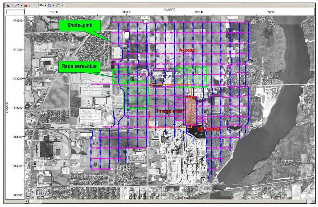
29 Ideal design Case of shots in permitted areas only. Receiver locations relatively unrestricted Ideal design with planned offsets Final design Access to known permitted areas only. Acquired data

30


31 from Leetaru, ISGS Valley eroded into Precambrian Precambrian structural high


32 Top of Mount Simon Structure 2D in Time Base Mount Simon Structure from Leetaru, ISGS 3D in Depth (ft)
33 March x 32 km Eclipse* reservoir model ~ 3 million grid cells variable cell dimensions *Mark of Schlumberger from Schlumberger Carbon Serv


34 2014 from Schlumberger Carbon Serv

35 From Schlumberger Carbon Services 24 levels of the 3-Component geophones are collecting microseismic data. Active Levels are 8 to 31. Inactive, are levels 1 to 7, not shown Verification Well #1 Geophysical Well #1 With OYO 3C geophones Ground Level Two of the 4-Component geophones are within the Mt. Simon, the third is positioned above the caprock (Eau Claire Shale). Perforation Zone Within the Mt. Simon ADM CCS #1 (Injection well) With PS3 OYO 4C geophones TD= 7236 feet MD St. Peter Sandstone Top of the Mt. Simon Sandstone Granite Wash (Base of the Mt. Simon) 35

36 Preliminary Analysis Injection Well with Sensors Four component geophones deployed in injection well adequate to monitor activity Microseismic events clustered mainly in four groups NW of verification well Events predominately in minus 0.5 to minus 2.0 magnitude Event clusters elongated roughly parallel to basinal σ 1 direction from Schlumberger Carbon Services

37 from Schlumberger Carbon Services

38 From Schlumberger Carbon Services
39 Verification Well Monitoring Data (to 24 March 2013) 11 bar (162 psi) Z4: 2.6 bar (38 psi) 33 m Z6: 1 bar(14 psi) 96 m
40 Mount Simon Sandstone reservoir is accepting CO 2 more easily than expected resulting in quicker detection at verification well Upward plume growth limited by reservoir permeability stratification, as modeled, and confirmed by pressure observations Resulting plume believed thinner than expected and was not definitively detected with a 3D vertical seismic profile at 75,000 tonnes cumulative injection in March 2012; new survey shot in 4-5 April 2013 Mt. Simon 200,000 ppm brine is more corrosive than expected, leading to corrosion of verification well cabling and need to replace corrosion inhibitor in well sooner than expected With 453,000+ tonnes injected, CO 2 remains in lowermost Mt. Simon; internal reservoir heterogeneity affecting CO 2 distribution


41 Midwest Geological Sequestration Consortium Photo credits: Daniel Byers
The Illinois Basin Decatur Project Decatur, Illinois USA: Overview and Impacts. Sallie E. Greenberg
 The Illinois Basin Decatur Project Decatur, Illinois USA: Overview and Impacts Sallie E. Greenberg Midwest Geological Sequestration Consortium SECARB Annual Meeting 12 March 2015 Acknowledgements The Midwest
An Assessment of Geological Carbon Sequestration in the Illinois Basin: The Illinois Basin-Decatur Site
 An Assessment of Geological Carbon Sequestration in the Illinois Basin: The Illinois Basin-Decatur Site presented by Robert J. Finley and the MGSC Project Team April 15, 2009 Illinois Sustainable Technology
Developments in Storage and Monitoring for CCUS
 Developments in Storage and Monitoring for CCUS Steve Whittaker Director Energy Research & Development Illinois State Geological Survey 4 th Beijing International Forum on Carbon Capture, Utilization and
Source Sink Pipeline
 An Overview of Carbon Storage presented by Robert J. Finley Advanced Energy Technology Initiative Illinois State Geological Survey University of Illinois USA IEA Summer School Longyearbyen, Norway August,
ADM CCS Projects Experience and Lessons Learned
 ADM CCS Projects Experience and Lessons Learned CSLF Technical Workshop June 17, 2015 Scott McDonald Biofuels Development Director scott.mcdonald@adm.com Acknowledgements The Industrial Carbon Capture
By: Jared T. Freiburg Illinois State Geological Survey 5/17/ cm
 Current Research on the Mt. Simon Geology; Refining the Lower Mt. Simon Depositional Interpretation By: Jared T. Freiburg Illinois State Geological Survey freiburg@illinois.edu 5/17/2016 2.5 cm Collaborators
Illinois Industrial Carbon Capture & Storage Project
 Illinois Industrial Carbon Capture & Storage Project Eliminating CO2 Emissions from the Production of Bio Fuels - A Green Carbon Process Envisioning a Carbon Negative Economy Workshop September 5, 2014
Monitoring with Time-lapse 3D VSPs at the Illinois Basin Decatur Project
 Monitoring with Time-lapse 3D VSPs at the Illinois Basin Decatur Project Marcia L. Couëslan Senior Geophysicist 18 September 2012 www.slb.com/carbonservices Acknowledgements Rob Finley, Sallie Greenberg,
Illinois Industrial Carbon Capture & Storage Project
 Illinois Industrial Carbon Capture & Storage Project Eliminating CO 2 Emissions from the Production of Bio Fuels - A Green Carbon Process IEA Bio-CCUS Workshop May 10, 2016 Scott McDonald Biofuels Development
IBDP Pre-Injection Microseismicity
 VW1 CCS1 Z feet (msl) IBDP Pre-Injection Microseismicity Valerie Smith, Senior Reservoir Geophysicist October 8, 2013 Processing by: Paul Jaques, Systems Engineer, Schlumberger Cambridge Research www.slb.com/carbonservices
Geologic and Reservoir Characterization and Modeling
 Geologic and Reservoir Characterization and Modeling Scott M. Frailey and James Damico Illinois State Geological Survey Midwest Geologic Sequestration Science Conference November 8 th, 2011 Acknowledgements
Kentucky Geological Survey Marvin Blan #1 Hancock County, Kentucky Geologic Review. J. Richard Bowersox David A. Williams Kentucky Geological Survey
 Kentucky Geological Survey Marvin Blan #1 Hancock County, Kentucky Geologic Review J. Richard Bowersox David A. Williams Kentucky Geological Survey KYCCS Western Kentucky Project Review Lexington, Kentucky
Western Kentucky CO 2 Storage Test
 Western Kentucky CO 2 Storage Test Principal Investigators: Rick Bowersox - Lexington Dave Williams - Henderson KGS First Friday Seminar Lexington, Kentucky March 4, 2011 The project proceeded in two phases:
Basin-scale Modeling of CO 2 Sequestration in the Illinois Basin Status Report
 Basin-scale Modeling of CO 2 Sequestration in the Illinois Basin Status Report Edward Mehnert, James Damico, Scott Frailey, Hannes Leetaru, Yu-Feng Lin, Roland Okwen Illinois State Geological Survey, Prairie
Basin-Scale Hydrological Impact of Geologic Carbon Sequestration in the Illinois Basin: A Full-Scale Deployment Scenario
 Basin-Scale Hydrological Impact of Geologic Carbon Sequestration in the Illinois Basin: A Full-Scale Deployment Scenario Quanlin Zhou, Jens Birkholzer Earth Sciences Division Lawrence Berkeley National
Measurement, Monitoring and Verification (MMV)
") Measurement, Monitoring and Verification (MMV) Larry Myer USCSC CCS Capacity Building Workshop Charleston, West Virginia October 25, 2011 Outline Why monitor? Information needs Monitoring methods Baselines
Measurement, Monitoring and Verification (MMV) Larry Myer USCSC CCS Capacity Building Workshop Charleston, West Virginia October 25, 2011 Outline Why monitor? Information needs Monitoring methods Baselines
CO2 Storage- Project list
 a) NGI involvement with CO 2 storage field sites, pilots and demos 1. In Salah CO2 storage In Salah is located in Krechba, central Algeria. Injection of CO 2 started in 2004 and halted in 2011. A total
Western Kentucky Deep Saline Reservoir CO 2 Storage Test. Principal Investigators: J. Richard Bowersox - Lexington David A. Williams - Henderson
 Western Kentucky Deep Saline Reservoir CO 2 Storage Test Principal Investigators: J. Richard Bowersox - Lexington David A. Williams - Henderson August 12, 2008 Electric power generating and industrial
ILLINOIS GROUNDWATER - BEDROCK
 ILLINOIS GROUNDWATER - BEDROCK Northern Illinois Fresh Water Water Supply Shallow Bedrock Aquifers < 500 depth Deep Bedrock Aquifers > 500 depth Southern Illinois Saline water Oil Fracking Coal Waste injection
Developments on Microseismic Monitoring and Risk Assessment of Large-scale CO 2 Storage
 Developments on Microseismic Monitoring and Risk Assessment of Large-scale CO 2 Storage Bettina Goertz-Allmann NORSAR CCS Technical Workshop, RITE, Tokyo, January 16, 2019 Outline Introduction: Induced
Recommendations for Injection and Storage Monitoring
 Energy and Environmental Systems Group Institute for Sustainable Energy, Environment and Economy (ISEEE) Recommendations for Injection and Storage Monitoring WABAMUN AREA CO 2 SEQUESTRATION PROJECT (WASP)
Western Kentucky Deep Saline Reservoir CO 2 Storage Test. Principal Investigators: J. Richard Bowersox - Lexington David A. Williams - Henderson
 Western Kentucky Deep Saline Reservoir CO 2 Storage Test Principal Investigators: J. Richard Bowersox - Lexington David A. Williams - Henderson July 22, 2008 Electric power generating and industrial plants
Jackson County 2013 Weather Data
 Jackson County 2013 Weather Data 61 Years of Weather Data Recorded at the UF/IFAS Marianna North Florida Research and Education Center Doug Mayo Jackson County Extension Director 1952-2008 Rainfall Data
Norway Grants. Activity 2. Building a 3D static geological model of the storage site and storage complex
 Preparation for a pilot project of CO2 geological storage in the Czech Republic Activity 2 Norway Grants Juraj Francu Oldřich Krejčí Czech Geological Survey Brno Building a 3D static geological model of
West Coast Research. WESTCARB Technical Director California Energy Commission
 Field Experience from West Coast Research Larry Myer WESTCARB Technical Director California Energy Commission lrmyer@lbl.gov Carbon Capture & Sequestration Public Workshop Bakersfield, CA September 25,
Measurement, Monitoring & Verification. Dr. Lee H. Spangler, Director Zero Emission Research and Technology Center
 Measurement, Monitoring & Verification Dr. Lee H. Spangler, Director Zero Emission Research and Technology Center The Need for MMV Demonstration / Research Stage Health, Safety and Environmental concerns
Monitoring and Verification of CO 2 Storage in Geological Formations Sally M. Benson Lawrence Berkeley National Laboratory Berkeley, CA 94720
 Monitoring and Verification of CO 2 Storage in Geological Formations Sally M. Benson Lawrence Berkeley National Laboratory Berkeley, CA 94720 Global Climate & Energy Project (GCEP) International Workshop
Midwest Regional Carbon Sequestration Partnership (MRCSP) Press Briefing. February 21, 2008
 Press Briefing. February 21, 2008") Midwest Regional Carbon Sequestration Partnership (MRCSP) Michigan Basin Test Site Press Briefing Introduction and Overview: Abed Houssari, DTE Energy DOE s Sequestration Program: Lynn Brickett, US DOE/NETL
Midwest Regional Carbon Sequestration Partnership (MRCSP) Michigan Basin Test Site Press Briefing Introduction and Overview: Abed Houssari, DTE Energy DOE s Sequestration Program: Lynn Brickett, US DOE/NETL
Monthly Magnetic Bulletin
 BRITISH GEOLOGICAL SURVEY Ascension Island Observatory Monthly Magnetic Bulletin December 2008 08/12/AS Crown copyright; Ordnance Survey ASCENSION ISLAND OBSERVATORY MAGNETIC DATA 1. Introduction Ascension
Western Kentucky Deep Saline Reservoir CO 2 Storage Test. Principal Investigators: J. Richard Bowersox - Lexington David A. Williams - Henderson
 Western Kentucky Deep Saline Reservoir CO 2 Storage Test Principal Investigators: J. Richard Bowersox - Lexington David A. Williams - Henderson October 2, 2008 Electric power generating and industrial
Seismic Data and Drilling in Hancock Co., Kentucky February 21, 2008
 Seismic Data and Drilling in Hancock Co., Kentucky February 21, 2008 J.A. Drahovzal 2/21/08 1 Hancock County (H1) Information Provided at 2/7/08 Meeting Depth of Top (t) and Thickness (th) in feet t Kn
Jackson County 2018 Weather Data 67 Years of Weather Data Recorded at the UF/IFAS Marianna North Florida Research and Education Center
 Jackson County 2018 Weather Data 67 Years of Weather Data Recorded at the UF/IFAS Marianna North Florida Research and Education Center Doug Mayo Jackson County Extension Director 1952-2008 Rainfall Data
The Ketzin Test Site (former CO 2 Sink-project)
") The Ketzin Test Site (former CO 2 Sink-project) - Experiences and results gained during 32 months of operation - Axel Liebscher & Ketzin Team The Ketzin Test Site ~ 25 km west of Berlin located in the
The Ketzin Test Site (former CO 2 Sink-project) - Experiences and results gained during 32 months of operation - Axel Liebscher & Ketzin Team The Ketzin Test Site ~ 25 km west of Berlin located in the
Midwest Regional Carbon Sequestration Partnership
 Midwest Regional Carbon Sequestration Partnership DOE/NETL Cooperative Agreement # DE-FC26-0NT42589 Neeraj Gupta, Battelle (gupta@battelle.org) Carbon Storage R&D Review Meeting Transforming Technology
WESTCARB Phase I Results Review
 WESTCARB Phase I Results Review Arizona Geologic Characterization Errol Montgomery Principal Errol L. Montgomery & Associates (520) 881-4912 emontgomery@elmontgomery.com November 9, 2005 Site Characterization
Atlantic Rim Coalbed Methane Play: The Newest SuccessfulCBM Play in the Rockies
 Atlantic Rim Coalbed Methane Play: The Newest SuccessfulCBM Play in the Rockies Robert A. Lamarre Lamarre Geological, Denver, Colorado Stephen K. Ruhl Anadarko Petroleum Corporation, The Woodlands, Texas
Jackson County 2014 Weather Data
 Jackson County 2014 Weather Data 62 Years of Weather Data Recorded at the UF/IFAS Marianna North Florida Research and Education Center Doug Mayo Jackson County Extension Director 1952-2008 Rainfall Data
FRIO BRINE SEQUESTRATION PILOT IN THE TEXAS GULF COAST
 I1-2 FRIO BRINE SEQUESTRATION PILOT IN THE TEXAS GULF COAST Susan D. Hovorka and Paul R. Knox Bureau of Economic Geology, John A. and Katherine G. Jackson School of Geosciences, The University of Texas
Where to Drill in Western Kentucky February
 Where to Drill in Western Kentucky? February 7. 2008 J.A. Drahovzal 2/7/08 Assumptions to Date and Questions Drill no more than 8,000 feet Drill multi-horizons (at least 2 major horizons) Do we want to
Internal microseismic event pattern revealed by waveform cross-correlation analysis
 Internal microseismic event pattern revealed by waveform cross-correlation analysis Bettina P. Goertz-Allmann, Volker Oye, Steven J. Gibbons, Robert Bauer, and Robert Will MGSC annual meeting September
Geologic CO 2 Storage Options for California
 Geologic CO 2 Storage Options for California Larry Myer WESTCARB Technical Director California Energy Commission lrmyer@lbl.gov Carbon Capture & Sequestration Public Workshops February 13 14, 2008 Outline
Assessment of CO 2 Enhanced Gas Recovery in Shale Gas Reservoirs (Preliminary)*
*") Assessment of CO 2 Enhanced Gas Recovery in Shale Gas Reservoirs (Preliminary)* Brandon C. Nuttall 1, Michael L. Godec 2, Robert J. Butsch 3, and David E. Riestenberg 4 Search and Discovery Article #80296
Assessment of CO 2 Enhanced Gas Recovery in Shale Gas Reservoirs (Preliminary)* Brandon C. Nuttall 1, Michael L. Godec 2, Robert J. Butsch 3, and David E. Riestenberg 4 Search and Discovery Article #80296
region includes nine states and four provinces, covering over 1.4 million square miles. The PCOR Partnership
 Overview of Phase II PCOR Partnership MVA Activities IEAGHG Monitoring Network Meeting Natchez, MS May 6-8, 2010 Steven A. Smith, Energy & Environmental Research Center The Plains CO 2 Reduction (PCOR)
Monthly Magnetic Bulletin
 BRITISH GEOLOGICAL SURVEY Ascension Island Observatory Monthly Magnetic Bulletin March 2017 17/03/AS Crown copyright; Ordnance Survey ASCENSION ISLAND OBSERVATORY MAGNETIC DATA 1. Introduction Ascension
Monthly Magnetic Bulletin
 BRITISH GEOLOGICAL SURVEY Port Stanley Observatory Monthly Magnetic Bulletin December 2007 07/12/PS Jason Islands a ar C West Falkland Kin gg eor ge B Port Salavador ay Weddell Island Mount Osborne So
GAMINGRE 8/1/ of 7
 FYE 09/30/92 JULY 92 0.00 254,550.00 0.00 0 0 0 0 0 0 0 0 0 254,550.00 0.00 0.00 0.00 0.00 254,550.00 AUG 10,616,710.31 5,299.95 845,656.83 84,565.68 61,084.86 23,480.82 339,734.73 135,893.89 67,946.95
The UK GeoEnergy Test Bed Ceri J Vincent British Geological Survey
 The UK GeoEnergy Test Bed Ceri J Vincent British Geological Survey Thanks to Matthew Hall (GTB Theme Lead for G ERA), Phil Meldrum, Russell Swift, Oliver Kuras, Richard Luckett, Andrew Butcher, Jonathan
Available online at GHGT-9. Elsevier use only: Received date here; revised date here; accepted date here
 Available online at www.sciencedirect.com Energy Procedia 00 1 (2009) (2008) 2193 2200 000 000 Energy Procedia www.elsevier.com/locate/procedia www.elsevier.com/locate/xxx GHGT-9 Designing a seismic program
Preliminary TOUGH2 Model of King Island CO 2 Injection. Modeling Approach
 Preliminary TOUGH2 Model of King Island CO 2 Injection Christine Doughty Presented by Curt Oldenburg Earth Sciences Division Lawrence Berkeley National Laboratory October 25, 2011 Modeling Approach Characterization
Monthly Magnetic Bulletin
 BRITISH GEOLOGICAL SURVEY Port Stanley Observatory Monthly Magnetic Bulletin April 2009 09/04/PS Jason Islands a ar C West Falkland Kin gg eor ge B Port Salavador ay Weddell Island Mount Osborne So un
Monthly Magnetic Bulletin
 BRITISH GEOLOGICAL SURVEY Port Stanley Observatory Monthly Magnetic Bulletin July 2009 09/07/PS Jason Islands a ar C West Falkland Kin gg eor ge B Port Salavador ay Weddell Island Mount Osborne So un d
Monthly Magnetic Bulletin
 BRITISH GEOLOGICAL SURVEY Port Stanley Observatory Monthly Magnetic Bulletin May 2009 09/05/PS Jason Islands a ar C West Falkland Kin gg eor ge B Port Salavador ay Weddell Island Mount Osborne So un d
Borehole Seismic Monitoring of Injected CO 2 at the Frio Site
 Borehole Seismic Monitoring of Injected CO 2 at the Frio Site * Daley, T M (tmdaley@lbl.gov), Lawrence Berkeley National Lab., 1 Cyclotron Rd, Berkeley, CA 94720 Myer, L (lrmyer@lbl.gov), Lawrence Berkeley
Project Assessment and Evaluation of the Area of Review (AoR) at the Citronelle SECARB Phase III Site, Alabama USA
 at the Citronelle SECARB Phase III Site, Alabama USA") Project Assessment and Evaluation of the Area of Review (AoR) at the Citronelle SECARB Phase III Site, Alabama USA Prepared for: GHGT 12 Prepared By: George J. Koperna, Jr., Vice President Steven M. Carpenter,
Project Assessment and Evaluation of the Area of Review (AoR) at the Citronelle SECARB Phase III Site, Alabama USA Prepared for: GHGT 12 Prepared By: George J. Koperna, Jr., Vice President Steven M. Carpenter,
Monthly Magnetic Bulletin
 BRITISH GEOLOGICAL SURVEY Port Stanley Observatory Monthly Magnetic Bulletin July 2011 11/07/PS Jason Islands West Falkland King George Bay Queen Charlotte Bay Weddell Island Caracass Island Saunders Island
Champaign-Urbana 2001 Annual Weather Summary
 Champaign-Urbana 2001 Annual Weather Summary ILLINOIS STATE WATER SURVEY 2204 Griffith Dr. Champaign, IL 61820 wxobsrvr@sws.uiuc.edu Maria Peters, Weather Observer January: After a cold and snowy December,
Stream Discharge and the Water Budget
 Regents Earth Science Unit 6: Water Cycle & Climate Name: Lab # Stream Discharge and the Water Budget Introduction: The United States Geological Survey (USGS) measures and publishes values for the daily
Current challenges at CO 2 Sites
 Current challenges at CO 2 Sites Ola Eiken et al., Statoil R&D Force seminar on injection safety 4 th December 2013 Offshore Sleipner Onshore In Salah Sub-sea Snøhvit 1 - Classification: External 2010-09-23
Monthly Magnetic Bulletin
 BRITISH GEOLOGICAL SURVEY Port Stanley Observatory Monthly Magnetic Bulletin July 2010 10/07/PS Jason Islands a ar C West Falkland Kin gg eor ge B Port Salavador ay Weddell Island Mount Osborne So un d
REDWOOD VALLEY SUBAREA
 Independent Science Review Panel Conceptual Model of Watershed Hydrology, Surface Water and Groundwater Interactions and Stream Ecology for the Russian River Watershed Appendices A-1 APPENDIX A A-2 REDWOOD
Carbon Sequestration in Basalts: Laboratory Studies and Field Demonstration
 Carbon Sequestration in Basalts: Laboratory Studies and Field Demonstration H. T. Schaef B.P. McGrail Workshop on Geologic Capture and Sequestration of Carbon Stanford University November 28, 2017 Needles
January 25, Summary
 January 25, 2013 Summary Precipitation since the December 17, 2012, Drought Update has been slightly below average in parts of central and northern Illinois and above average in southern Illinois. Soil
KING EDWARD POINT OBSERVATORY MAGNETIC DATA
 BRITISH GEOLOGICAL SURVEY King Edward d Point Observatory Monthly Magnetic Bulletin September 2018 18/09/KE King Edward Point (UK) Maps British Antarctic Survey KING EDWARD POINT OBSERVATORY MAGNETIC DATA
Available online at ScienceDirect. Energy Procedia 63 (2014 ) GHGT-12
 GHGT-12") Available online at www.sciencedirect.com ScienceDirect Energy Procedia 63 (2014 ) 2977 2984 GHGT-12 Characterization of the Aquistore CO 2 project storage site, Saskatchewan, Canada. Ben Rostron a *,
Available online at www.sciencedirect.com ScienceDirect Energy Procedia 63 (2014 ) 2977 2984 GHGT-12 Characterization of the Aquistore CO 2 project storage site, Saskatchewan, Canada. Ben Rostron a *,
Storage: Deep Monitoring and Verification
 Storage: Deep Monitoring and Verification IEA GHG Summer School, Austin, TX David White 7 th to 11 th July, 2014 www.slb.com/carbonservices CS1406-063-DW Why Monitor? Manage Risk Risk = (Impact of Undesirable
KING EDWARD POINT OBSERVATORY MAGNETIC DATA
 BRITISH GEOLOGICAL SURVEY King Edward d Point Observatory Monthly Magnetic Bulletin October 2018 18/10/KE King Edward Point (UK) Maps British Antarctic Survey KING EDWARD POINT OBSERVATORY MAGNETIC DATA
Anatomy of a Coal Bed Fire
 Stanford University Global Climate & Energy Project GCEP Symposium Stanford October 3, 2008 Anatomy of a Coal Bed Fire Taku Ide and Lynn Orr Geologic Storage of CO 2 in Coal Beds Deep unmineable coal beds
Jackson County 2019 Weather Data 68 Years of Weather Data Recorded at the UF/IFAS Marianna North Florida Research and Education Center
 Jackson County 2019 Weather Data 68 Years of Weather Data Recorded at the UF/IFAS Marianna North Florida Research and Education Center Doug Mayo Jackson County Extension Director 1952-2008 Rainfall Data
Long-term Water Quality Monitoring in Estero Bay
 Long-term Water Quality Monitoring in Estero Bay Keith Kibbey Laboratory Director Lee County Environmental Laboratory Division of Natural Resource Management Estero Bay Monitoring Programs Three significant
Geological CO 2 Storage Feasibility Study: Saline Aquifers and Depleted Oil Fields, Ordos Basin, Shaanxi Province
 U.S. - CHINA CLEAN ENERGY RESEARCH CENTER 中国清洁能源研究中心 Northwest University Geological CO 2 Storage Feasibility Study: Saline Aquifers and Depleted Oil Fields, Ordos Basin, Shaanxi Province 1 Ronald Surdam,
Wind Resource Data Summary Cotal Area, Guam Data Summary and Transmittal for December 2011
 Wind Resource Data Summary Cotal Area, Guam Data Summary and Transmittal for December 2011 Prepared for: GHD Inc. 194 Hernan Cortez Avenue 2nd Floor, Ste. 203 Hagatna, Guam 96910 January 2012 DNV Renewables
Prepared For: NRAP Stakeholders Meeting February 4 and 5 th, Prepared By: George Koperna, VP ADVANCED RESOURCES INTERNATIONAL, INC.
 SECARB Anthropogenic Test Prepared For: NRAP Stakeholders Meeting February 4 and 5 th, 2014 Prepared By: George Koperna, VP ADVANCED RESOURCES INTERNATIONAL, INC. Acknowledgement This presentation is based
Saline Formations MRCSP and Mountaineer Update
 Carbon Dioxide Storage in Deep Saline Formations MRCSP and Mountaineer Update Neeraj Gupta, Ph.D. Research Leader Battelle, Columbus, Ohio Phone: 614-424-3820, E-Mail: gupta@battelle.org WV Energy Summit
Chiang Rai Province CC Threat overview AAS1109 Mekong ARCC
 Chiang Rai Province CC Threat overview AAS1109 Mekong ARCC This threat overview relies on projections of future climate change in the Mekong Basin for the period 2045-2069 compared to a baseline of 1980-2005.
KING EDWARD POINT OBSERVATORY MAGNETIC DATA
 BRITISH GEOLOGICAL SURVEY King Edward d Point Observatory Monthly Magnetic Bulletin May 2018 18/05/KE King Edward Point (UK) Maps British Antarctic Survey KING EDWARD POINT OBSERVATORY MAGNETIC DATA 1.
The Impacts of Carbon Dioxide Storage in the Saline Arbuckle Aquifer on Water Quality in Freshwater Aquifers in Kansas
 The Impacts of Carbon Dioxide Storage in the Saline Arbuckle Aquifer on Water Quality in Freshwater Aquifers in Kansas Tiraz Birdie, Lynn Watney, Paul Gerlach, Michael Killion, Jennifer Raney, Eugene Holubnyak,
Climatography of the United States No
 Climate Division: AK 5 NWS Call Sign: ANC Month (1) Min (2) Month(1) Extremes Lowest (2) Temperature ( F) Lowest Month(1) Degree s (1) Base Temp 65 Heating Cooling 90 Number of s (3) Jan 22.2 9.3 15.8
Andrew Lee BEng (Hons) CEng MIStructE FGS FPWS
 CEng MIStructE FGS FPWS") Jim Twaddle BSc (Hons) FGS Andrew Lee BEng (Hons) CEng MIStructE FGS FPWS 22 January 2010 ME50231/RE001 !! "# # $ " %! &' ( "# # $ ) # ' %! "# # $ # "# # $ * + # "# # $ "! # "# # $, # "# # $! -( +.!!/
Jim Twaddle BSc (Hons) FGS Andrew Lee BEng (Hons) CEng MIStructE FGS FPWS 22 January 2010 ME50231/RE001 !! "# # $ " %! &' ( "# # $ ) # ' %! "# # $ # "# # $ * + # "# # $ "! # "# # $, # "# # $! -( +.!!/
Seismic mapping of the Utsira Formation. Petrophysical interpretations and fracture gradient estimates.
 Presentation March 4 th 2009 OG21 Innovation Seminar: TTA2 Exploration and reservoir Characterization Venue: StatoilHydro, Sandsli CO 2 Sequestration A geophysical and geological study related to CO 2
MIDWEST REGIONAL CARBON SEQUESTRATION PARTNERSHIP PHASE II STORAGE CAPACITY POTENTIAL OVERVIEW
 FINAL MIDWEST REGIONAL CARBON SEQUESTRATION PARTNERSHIP PHASE II STORAGE CAPACITY POTENTIAL OVERVIEW SUMMARY OF PHASE II TOPICAL REPORTS DOE-NETL Cooperative Agreement DE-FC26-05NT42589 Submitted by: Battelle
The Climate of Bryan County
 The Climate of Bryan County Bryan County is part of the Crosstimbers throughout most of the county. The extreme eastern portions of Bryan County are part of the Cypress Swamp and Forest. Average annual
5 IEAGHG CCS Summer School. Geological storage of carbon dioxide (a simple solution)
") Storage 1- Reservoirs, Traps, Seals and Storage Capacity for Storage Geological storage of carbon dioxide (a simple solution) Professor John Kaldi Chief Scientist, CO2CRC Australian School of Petroleum,
Storage 1- Reservoirs, Traps, Seals and Storage Capacity for Storage Geological storage of carbon dioxide (a simple solution) Professor John Kaldi Chief Scientist, CO2CRC Australian School of Petroleum,
Reservoir simulation and feasibility study for seismic monitoring at CaMI.FRS, Newell County, Alberta
 Reservoir simulation and feasibility study for seismic monitoring at CaMI.FRS, Newell County, Alberta Marie Macquet 1,Donald C. Lawton 1,2 and Amin Saeedfar 2 1 CREWES, University of Calgary; 2 CMC Research
Pressure Prediction and Hazard Avoidance through Improved Seismic Imaging
 Pressure Prediction and Hazard Avoidance through Improved Seismic Imaging 12121-6002-02 Bill Barkhouse SEG Advanced Modeling Corporation (SEAM) RPSEA / SPE-GCS Ultra-Deepwater Technology Conference September
secarb.org Southeast Regional Carbon Sequestration Partnership (SECARB) Central Appalachian Coal Seam Project
 Central Appalachian Coal Seam Project") Southeast Regional Carbon Sequestration Partnership (SECARB) secarb.org Field Test Location Russell County, Virginia Amount and Sources of CO 2 1,000 Tons from Commercial Source Primary Contacts DOE/NETL
Southeast Regional Carbon Sequestration Partnership (SECARB) secarb.org Field Test Location Russell County, Virginia Amount and Sources of CO 2 1,000 Tons from Commercial Source Primary Contacts DOE/NETL
January 22, Coronado National Forest 300 West Congress Street Tucson, AZ Jim Upchurch, Forest Supervisor. Dear Mr.
 January 22, 2015 Coronado National Forest 300 West Congress Street Tucson, AZ 85701 Attn: Jim Upchurch, Forest Supervisor Dear Mr. Upchurch: In your letter dated January 16, 2015, you requested that Hudbay
Monthly Magnetic Bulletin
 BRITISH GEOLOGICAL SURVEY Jim Carrigan Observatory Prudhoe Bay Monthly Magnetic Bulletin May 2014 14/05/JC JIM CARRIGAN OBSERVATORY MAGNETIC DATA 1. Introduction Jim Carrigan observatory is the fourth
The Climate of Pontotoc County
 The Climate of Pontotoc County Pontotoc County is part of the Crosstimbers. This region is a transition region from the Central Great Plains to the more irregular terrain of southeast Oklahoma. Average
SECARB Phase III ANTHROPOGENIC TEST: Risk Management through Detailed Geologic Characterization and Modeling
 SECARB Phase III ANTHROPOGENIC TEST: Risk Management through Detailed Geologic Characterization and Modeling Prepared by: David Riestenberg, George Koperna, and Vello Kuuskraa, Advanced Resources International,
Analysis of mining deformations based on PSInSAR technique case study of the Walbrzych coal mines (Poland)
") Analysis of mining deformations based on PSInSAR technique case study of the Walbrzych coal mines (Poland) Dr. Jan Blachowski, Dr. Wojciech Milczarek Faculty of Geoengineering, Mining and Geology, Wroclaw
Analysis of mining deformations based on PSInSAR technique case study of the Walbrzych coal mines (Poland) Dr. Jan Blachowski, Dr. Wojciech Milczarek Faculty of Geoengineering, Mining and Geology, Wroclaw
Monitoring techniques developed at CO2 natural laboratories to improve risks assessment and safety strategy
 Monitoring techniques developed at CO2 natural laboratories to improve risks assessment and safety strategy Sabina Bigi Dipartimento di Scienze della Terra Sapienza Università di Roma 3 rd International
Evapo-transpiration Losses Produced by Irrigation in the Snake River Basin, Idaho
 Nov 7, 2007 DRAFT Evapo-transpiration Losses Produced by Irrigation in the Snake River Basin, Idaho Wendell Tangborn and Birbal Rana HyMet Inc. Vashon Island, WA Abstract An estimated 8 MAF (million acre-feet)
Colorado s Underground Injection Control Program: Prevention and Mitigation of Induced Seismicity
 Colorado s Underground Injection Control Program: Prevention and Mitigation of Induced Seismicity Energy & Environment Symposium April 2015 Robert P. Koehler, PhD. UIC Lead OVERVIEW What is a UIC well?
3D time-lapse seismic monitoring of the pilot CO 2 storage site at Ketzin, Germany
 3D time-lapse seismic monitoring of the pilot CO 2 storage site at Ketzin, Germany Reflections on Seismic Acquisition, Utrecht, Feb 2017 Monika Ivandic, Christopher Juhlin and Fengjiao Zhang Department
Results of the Lacq pilot s monitoring Focus on microseismicity. Joëlle HY-BILLIOT 10 may - Venice
 DGEP/SCR/RD Results of the Lacq pilot s monitoring Focus on microseismicity Joëlle HY-BILLIOT 10 may - Venice CCS pilot, Lacq, France Introduction Key areas Presentation of the Lacq pilot Monitoring program
A Review of the 2007 Water Year in Colorado
 A Review of the 2007 Water Year in Colorado Nolan Doesken Colorado Climate Center, CSU Mike Gillespie Snow Survey Division, USDA, NRCS Presented at the 28 th Annual AGU Hydrology Days, March 26, 2008,
2016 Meteorology Summary
 2016 Meteorology Summary New Jersey Department of Environmental Protection AIR POLLUTION AND METEOROLOGY Meteorology plays an important role in the distribution of pollution throughout the troposphere,
An Open Air Museum. Success breeds Success. Depth Imaging; Microseismics; Dip analysis. The King of Giant Fields WESTERN NEWFOUNDLAND:
 VOL. 7, NO. 4 2010 GEOSCIENCE & TECHNOLOGY EXPLAINED GEO EXPRO VOL. 7, NO. 4 2010 Success breeds Success geoexpro.com Country Profile: Senegal Ocean Bottom Node Seismic WESTERN NEWFOUNDLAND: An Open Air
Geophysical Site Investigation (Seismic methods) Amit Prashant Indian Institute of Technology Gandhinagar
 Amit Prashant Indian Institute of Technology Gandhinagar") Geophysical Site Investigation (Seismic methods) Amit Prashant Indian Institute of Technology Gandhinagar Short Course on Geotechnical Aspects of Earthquake Engineering 04 08 March, 2013 Seismic Waves
Geophysical Site Investigation (Seismic methods) Amit Prashant Indian Institute of Technology Gandhinagar Short Course on Geotechnical Aspects of Earthquake Engineering 04 08 March, 2013 Seismic Waves
Changing Hydrology under a Changing Climate for a Coastal Plain Watershed
 Changing Hydrology under a Changing Climate for a Coastal Plain Watershed David Bosch USDA-ARS, Tifton, GA Jeff Arnold ARS Temple, TX and Peter Allen Baylor University, TX SEWRU Objectives 1. Project changes