Introduction Geology
|
|
|
- MargaretMargaret Wiggins
- 5 years ago
- Views:
Transcription
1
2
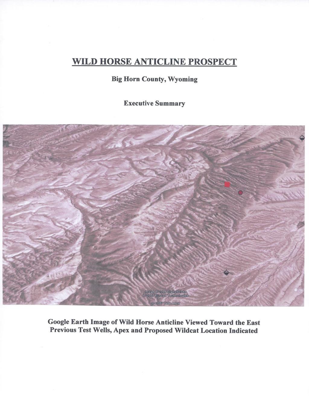
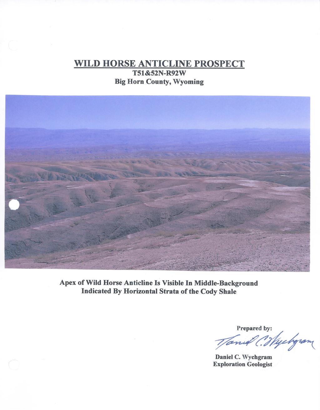
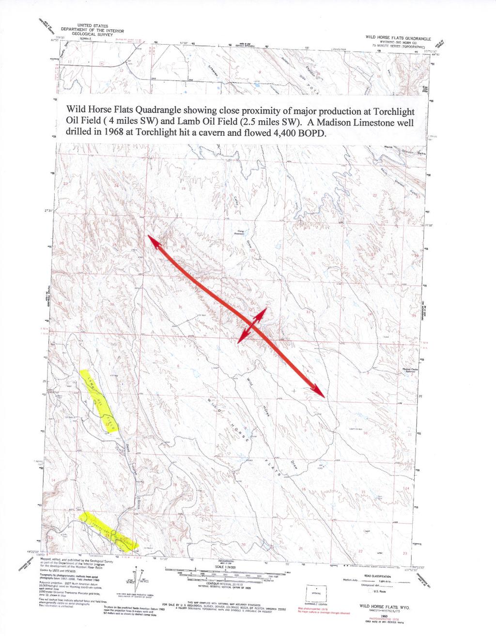
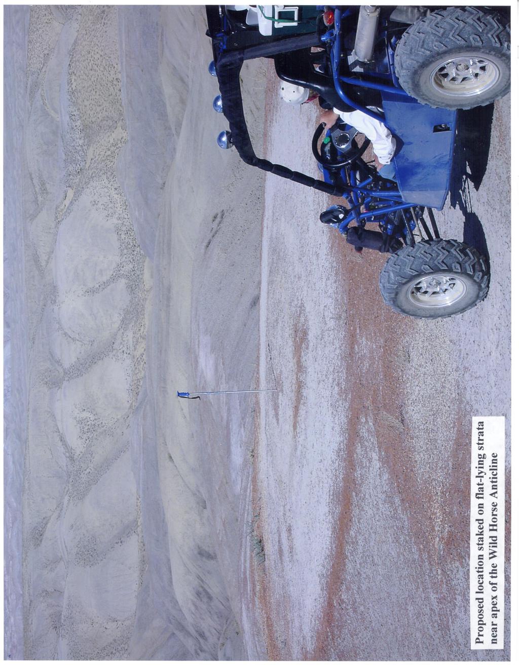
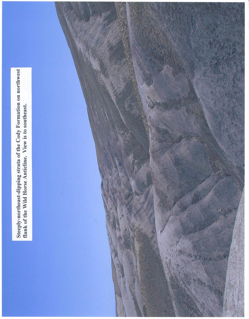
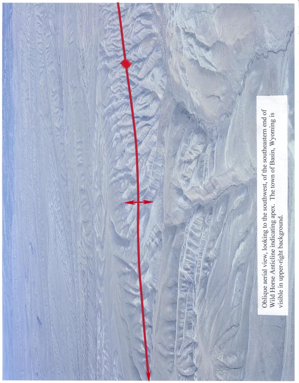
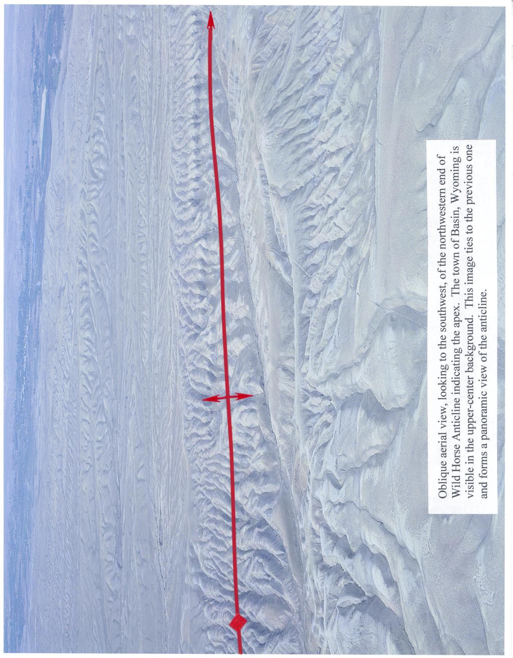
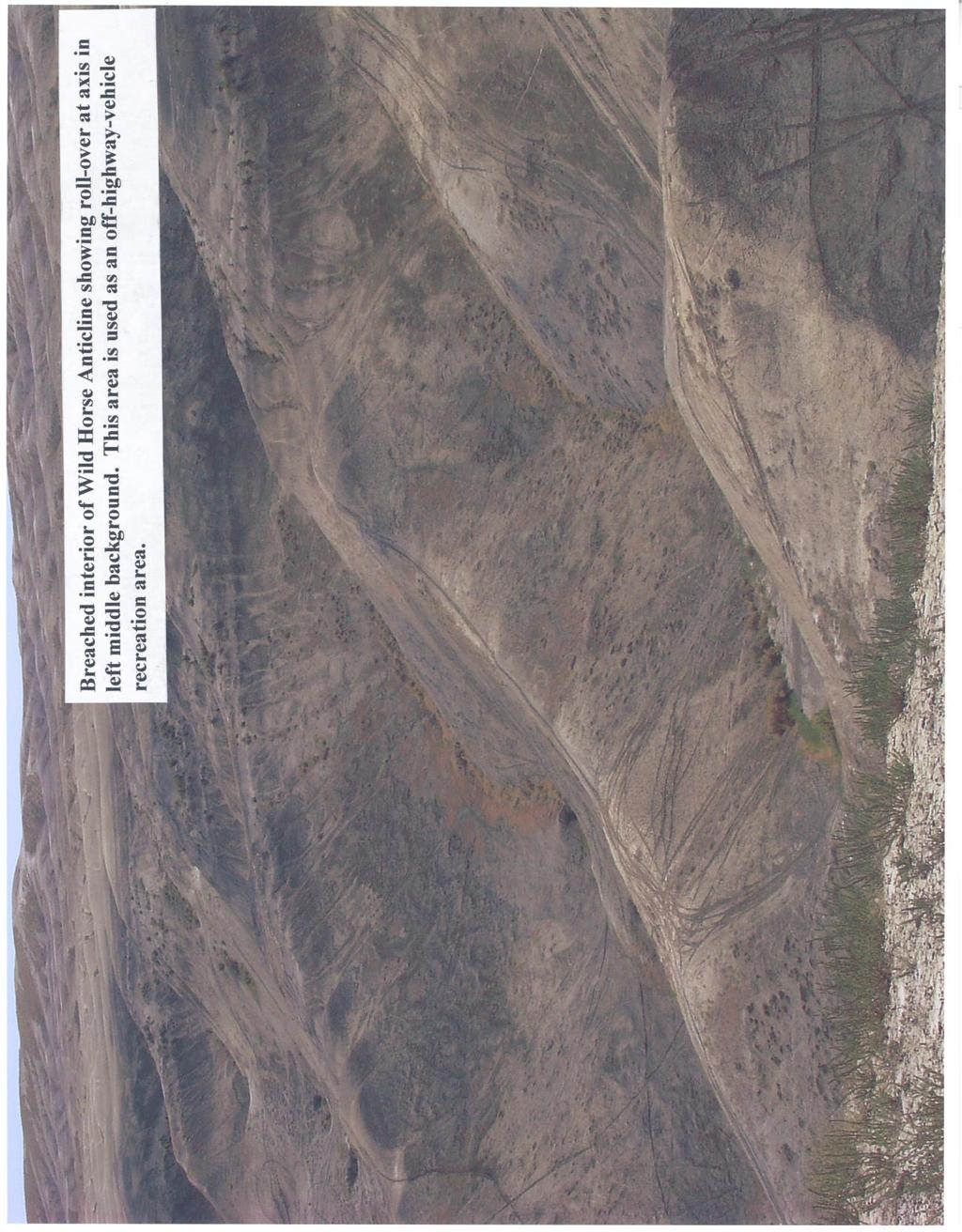
3 Introduction The Wild Horse Anticline is located in the prolific Bighorn Basin of Wyoming about 5 miles northeast of the town of Basin. This structure demonstrates excellent fourway closure encompassing an area of more than 1900 acres. Only four oil test wells have been drilled and these have been located far down dip on the flanks of the structure. The untested area of closure above these wells is approximately 1140 acres. The potential for high rates of production and large reserves is excellent. Torchlight Oil Field, 4 miles to the southwest, has produced 17 million barrels of oil. A Madison Limestone well drilled there in 1968 penetrated a cavern and came in flowing 4,400 BOPD. This well produced 858,000 barrels of oil in the first 16 months of production ². Four primary producing zones exist in the Wild Horse Anticlinal structure. The Frontier Formation offers the possibility of sweet green oil and gas at shallow depths. Sandstone strata, including the Peay Sand member of this formation, have produced over one million barrels of oil at nearby Greybull Oil Field. The Paleozoic Phosphoria Formation, Tensleep Sandstone and Madison Limestone are deeper targets that are reliable and prolific producers throughout the Bighorn Basin on similar structures. Geology Data from satellite imagery, high-altitude color-infrared photography viewed in stereo, the Wild Horse Flats Quadrangle and field observations were used to compile the map of the surface geology. Previously drilled wells in the area, although helpful in planning a wildcat test, are too sparsely spaced to allow meaningful sub-surface mapping. Detailed geologic mapping has revealed a primary and a secondary apex within the overall area of closure of the Wild Horse Anticline. The surface geology is dominated by only one formation--the Cody Shale. It was decided to map the Quaternary stream deposits since some of the stream segments are controlled by geologic structure. In this area, the Cody Shale contains several strata of varying competence. This erosional contrast is expressed in the topography and aids in mapping the geology. Several key beds were mapped but they follow the topographic contours so closely that it was decided not to place them on the topo-based map. A technique referred to as form-line analysis was used to create a structural contouring of the surface structure. The form-lines are controlled by strike, relative dip, key beds and outcrop pattern. Although this is a qualitative analysis, it is an accurate representation of the shape of the surface structure. It can be seen that the northeast limb of the anticline is considerably steeper than the southwest limb. As a consequence of this asymmetry, the axial plane is inclined to the southwest. Therefore, as the surface structure is projected to a subsurface formation, it must be migrated to the southwest proportionate to the depth of the projection. A proposed test well location was staked in the field as shown in the following photograph. It was selected to be near the primary surface apex but on the southwest side of the axis to compensate for migration of the apex at the Paleozoic oil zones. An important additional consideration is the locally rough terrain which sets practical limits as to where a location can be built and a drilling rig transported. An access road exists near the location which is not indicated on the 1960-vintage quadrangle map.
4
5
6 Wildcat Test Well and Previously Drilled Wells The well records for each well drilled in the mapped area were examined in detail. The elevation of the Phosphoria Formation top was calculated and placed on the map next to the well symbol. One well, the Ward Alfred & Son, was not drilled deep enough to penetrate the Paleozoics. The well data reinforce the form-line analysis when the analysis is migrated to the southwest a few hundred feet to compensate for the anticline s asymmetry. The Sierra Trading Corporation well is an exception. This well calculates as being the second highest well in the mapped area despite its location being further down the flank of the anticline. No explanation for this anomaly could be found. A formation thickness matrix was prepared and a weighted average thickness for each interval was determined. Based on the these thicknesses, and the assumption that the wildcat well would top the Frontier Formation at approximately 120 feet drilling depth, the following depth projections are calculated for the wildcat test well: Formation Depth Elevation Comments Cody Shale Surface +4,420 May need to be placed behind surface casing to prevent caving Frontier Fm ,300 Moderate oil & gas potential Mowry Shale Thermopolis Shale Muddy sandstone member has minor oil & gas potential Cloverly Fm Minor oil & gas potential Morrison Fm Minor oil potential Sundance Fm Minor oil potential Gypsum Springs Fm Chugwater Group Dinwoody Fm Phosphoria Fm Excellent oil potential Tensleep Sandstone Excellent oil potential Amsden Fm Madison Limestone Excellent oil potential TD Evaluate upper 300 feet Economics As with any wildcat prospect, economic expectations are speculative. In the following calculation for potential oil in place, the area used is the closed area above the highest dry hole, the Cominco American #2. This area is 1140 acres = the variable A. The reservoir parameters of thickness (h) and porosity (Φ) are taken from published data. Reservoir data from the Greybull Oil Field (five miles northwest) is used for the Frontier Formation and data from the Torchlight Oil Field (four miles to the southwest) is used for the Paleozoic formations. The variable oil saturation (So) is not given and assumed to be greater than 50% in order to be productive. Therefore, So = 50% is used throughout the calculations.
7 Frontier Formation Potential The reservoir parameters at Greybull Oil Field are for the Peay sandstone member of the Frontier Formation. The pay thickness is given as feet but the field-observed 35 feet is used here. The average porosity is given as 30%. The barrels of oil in place calculate: BO (in place) = VAhΦSo where V (volume constant) = 7,758 bbls/ac. Ft BO (in place) = (7,758)(1140 acres)(35 feet)(30%)(50%) = 46,431,630 BO Phosphoria Formation Potential The reservoir parameters at Torchlight Oil Field are used for the Phosphoria Formation. The pay thickness is given as 30 feet and the average porosity as 12%. The barrels of oil in place calculate: BO (in place) = (7,758)(1140)(30)(12%)(50%) = 15,919,416 BO Tensleep Sandstone Potential The reservoir parameters at Torchlight Oil Field are used for the Tensleep Sandstone. The pay thickness is given as 35 feet and the average porosity as 14%. The barrels of oil in place calculate: BO (in place) = (7758)(1140)(35)(14%)(50%) = 21,668,094 BO Madison Limestone Potential The reservoir parameters at Torchlight Oil Field are used for the Madison Limestone. The pay thickness is given as 70 feet and the average porosity is given as 16%. The barrels of oil in place calculate: BO (in place) = (7758)(1140)(70)(16%)(50%) = 49,527,072 BO Lease WYW This lease is a 10-year term federal/blm lease with an effective date of October 1, The lease includes 1,777 acres and covers the entire prospective area above the highest dry hole. There are no restrictive stipulations and the only notices are those that applies to all parcels. Of these, only the stipulation limiting development on slopes in excess of 25 percent would apply. One producing well located anywhere on the lease from any zone will HBP the entire oil field. References (included in map pocket) 1. Anonymous, 1989, Torchlight, in Wyoming Geological Association Symposium on Wyoming Oil and Gas Fields, Bighorn and Wind River Basins, P Dougan, Paul M., 2001, Equity Oil Company Annual Report 2001, P Mohl, Keith L., 1989, Greybull, in Wyoming Geological Association Symposium on Wyoming Oil and Gas Fields, Bighorn and Wind River Basins, P
8
9
10
11
12
13 References
14
15
16


17
18
19
EAS 233 Geologic Structures and Maps Winter Miscellaneous practice map exercises. 1. Fault and separation:
 Miscellaneous practice map exercises 1. Fault and separation: With respect to Map 1, what are (a) the orientation of the fault, and (b) the orientation of bedding in the units cut by the fault. (c) Mark
Testing of the Strawn Sand, White Hat 20#3, Mustang Prospect, Permian Basin, Texas
 Date: 11 April 2019 ASX Code: WEL Directors John Kopcheff Non-Executive Chairman Neville Henry Managing Director Peter Allchurch Non-Executive Director Larry Liu Non-Executive Director Lloyd Flint Company
Bighorn Basin ROZ Development
 Bighorn Basin ROZ Development David Mohrbacher Enhanced Oil Recovery Institute Presented at the 17 th Annual CO 2 Flooding Conference December 8-9, 2011 Midland, Texas Acknowledgements Dr. Peigui Yin Dr.
Structural Geology Lab. The Objectives are to gain experience
 Geology 2 Structural Geology Lab The Objectives are to gain experience 1. Drawing cross sections from information given on geologic maps. 2. Recognizing folds and naming their parts on stereoscopic air
APPENDIX C GEOLOGICAL CHANCE OF SUCCESS RYDER SCOTT COMPANY PETROLEUM CONSULTANTS
 APPENDIX C GEOLOGICAL CHANCE OF SUCCESS Page 2 The Geological Chance of Success is intended to evaluate the probability that a functioning petroleum system is in place for each prospective reservoir. The
Cretaceous, Dakota Formation, Terra Cotta Member South Side of I-70, Salina County, Kansas
 Cretaceous, Dakota Formation, Terra Cotta Member South Side of I-70, Salina County, Kansas Written By: Steven D.J. Baumann G-102010-1A Outcrop looking southeast Photo taken by: Steven Baumann on 10-20-2010
Update - Testing of the Strawn Sand, White Hat 20#3, Mustang Prospect, Permian Basin, Texas
 Date: 15 April 2019 ASX Code: WEL Directors John Kopcheff Non-Executive Chairman Neville Henry Managing Director Peter Allchurch Non-Executive Director Larry Liu Non-Executive Director Lloyd Flint Company
In this lab, we will study and analyze geologic maps from a few regions, including the Grand Canyon, western Wyoming, and coastal California.
 Name: Lab Section: work in groups, but each person turns in his/her own GEOSCIENCE 001 LAB UNDERSTANDING GEOLOGIC MAPS Geologic maps are colorful and even beautiful, but they also contain an amazing amount
Profit Island Project East Baton Rouge Parish, Louisiana
 Profit Island Project Lower Tuscaloosa Play Blue Moon Exploration Company has identified and leased four excellent low risk development opportunities for substantial reserves in the Profit Island Field
WESTCARB Phase I Results Review
 WESTCARB Phase I Results Review Arizona Geologic Characterization Errol Montgomery Principal Errol L. Montgomery & Associates (520) 881-4912 emontgomery@elmontgomery.com November 9, 2005 Site Characterization
P.R. SPRING AND HILL CREEK TAR SAND AREAS A RESOURCE ASSESSMENT (IN PROGRESS)
") P.R. SPRING AND HILL CREEK TAR SAND AREAS A RESOURCE ASSESSMENT (IN PROGRESS) presented by WALLY GWYNN - Utah Geological Survey at the Western U.S. Oil Sands Technology Transfer Meeting February 22, 2008
P.R. SPRING AND HILL CREEK TAR SAND AREAS A RESOURCE ASSESSMENT (IN PROGRESS) presented by WALLY GWYNN - Utah Geological Survey at the Western U.S. Oil Sands Technology Transfer Meeting February 22, 2008
UNDERSTANDING GEOLOGIC M APS
 Name: Lab Section: work in groups, but each person turns in his/her own GEOSCIENCE 001 L AB UNDERSTANDING GEOLOGIC M APS Geologic maps are colorful and even beautiful, but they also contain an amazing
SOUTHWEST & NORTHWEST EXPLORATION PROJECTS BINGHAM CANYON MINING DISTRICT
 SOUTHWEST & NORTHWEST EXPLORATION PROJECTS BINGHAM CANYON MINING DISTRICT SALT LAKE AND TOOELE COUNTIES, UTAH SUMMARY FRIDAY, MARCH 20, 2009 1 Tooele County Salt Lake County GOOGLE EARTH September, 2006
Quick Look Interpretation Techniques
 Quick Look Interpretation Techniques Odd Number of Contours A basic rule of contouring is that ALL contours on a continuous surface must close or end at the edge of the map. This rule seems so obvious
Oil and Gas Mineral Interest For Sale 2,145 acres in Cotton Valley/Hosston Sligo/Edwards Trend Exploration Trend
 Oil and Gas Mineral Interest For Sale 2,145 acres in Cotton Valley/Hosston Sligo/Edwards Trend Exploration Trend Milam County, Texas Fee Mineral interest is located in shallow oilfield discovered in 1940
THE STRUCTURE AND THICKNESS OF THE CLINTON AND BEREA FORMATIONS IN THE VICINITY OF WOOSTER, OHIO
 THE STRUCTURE AND THICKNESS OF THE CLINTON AND BEREA FORMATIONS IN THE VICINITY OF WOOSTER, OHIO KARL VER STEEG College of Wooster INTRODUCTION AND ACKNOWLEDGMENTS The data used in the construction of
Dakota Sandstone. of the Moxa Arch and Surrounding Green River Basin
 Dakota Sandstone of the Moxa Arch and Surrounding Green River Basin Dakota Sandstones of the Green River Basin Overview The Dakota sandstones of the Moxa Arch and surrounding Green River Basin remain attractive
CHARACTERIZATION OF FRACTURES AND THEIR EFFECT ON RESERVOIR DIRECTIONAL FLOW IN TENSLEEP SANDSTONES, WYOMING
 CHARACTERIZATION OF FRACTURES AND THEIR EFFECT ON RESERVOIR DIRECTIONAL FLOW IN TENSLEEP SANDSTONES, WYOMING Peigui Yin & Shaochang Wo Enhanced Oil Recovery Institute University of Wyoming Laramie, Wyoming
!'f \, w. Alan Stewart Colorado Exploration Company, Golden STRUCTURE OF THE FOOTHILLS AREA WEST OF DENVER, COLORADO. Introduction
 STRUCTURE OF THE FOOTHLLS AREA WEST OF DENVER, COLORADO w. Alan Stewart Colorado Exploration Company, Golden ntroduction i ; The dominant structural features west of Denver and along the mountain front
Steve Cumella 1. Search and Discovery Article # (2009) Posted July 30, Abstract
 Posted July 30, Abstract") AV Geology of the Piceance Basin Mesaverde Gas Accumulation* Steve Cumella 1 Search and Discovery Article #110106 (2009) Posted July 30, 2009 *Adapted from oral presentation at AAPG Annual Convention,
AV Geology of the Piceance Basin Mesaverde Gas Accumulation* Steve Cumella 1 Search and Discovery Article #110106 (2009) Posted July 30, 2009 *Adapted from oral presentation at AAPG Annual Convention,
Characterizing Seal Bypass Systems at the Rock Springs Uplift, Southwest Wyoming, Using Seismic Attribute Analysis*
 Characterizing Seal Bypass Systems at the Rock Springs Uplift, Southwest Wyoming, Using Seismic Attribute Analysis* Yuri Ganshin 1 and Fred McLaughlin 1 Search and Discovery Article #80483 (2015)** Posted
Western Kentucky CO 2 Storage Test
 Western Kentucky CO 2 Storage Test Principal Investigators: Rick Bowersox - Lexington Dave Williams - Henderson KGS First Friday Seminar Lexington, Kentucky March 4, 2011 The project proceeded in two phases:
GPR AS A COST EFFECTIVE BEDROCK MAPPING TOOL FOR LARGE AREAS. Abstract
 GPR AS A COST EFFECTIVE BEDROCK MAPPING TOOL FOR LARGE AREAS Dr. Jutta L. Hager, Hager GeoScience, Inc., Waltham, MA Mario Carnevale, Hager GeoScience, Inc., Waltham, MA Abstract Hager GeoScience, Inc.
Multiattributes and Seismic Interpretation of Offshore Exploratory Block in Bahrain A Case Study
 Multiattributes and Seismic Interpretation of Offshore Exploratory Block in Bahrain A Case Study Suresh Thampi, Aqeel Ahmed, Yahya Al-Ansari, Ali Shehab, Ahmed Fateh, Anindya Ghosh, Ghada Almoulani. The
A. Refer to Appendix F in back of lab manual for list of commonly used geologic map symbols
 Structural Geology Lab 2: Outcrop Patterns and Structure Contours I. Geologic Map Symbols A. Refer to Appendix F in back of lab manual for list of commonly used geologic map symbols 1. Emphasis: a. strike
QUARTERLY ACTIVITIES REPORT
 15 Rheola Street WEST PERTH WA 6005 Telephone: +61 8 9213 4388 Facsimile: +61 8 9213 4399 ASX Code: ETE ASX RELEASE 29 July 2011 QUARTERLY ACTIVITIES REPORT Entek Energy Limited provides the following
RELINQUISHMENT REPORT FOR LICENCE P.1663, BLOCK 29/4b and 29/5e
 RELINQUISHMENT REPORT FOR LICENCE P.1663, BLOCK 29/4b and 29/5e Licence: P.1663 Blocks: 29/4b & 29/5e 25th Round Traditional Licence Operator: Ithaca Energy UK(Ltd) 100% Work Programme Summary The agreed
MIDDLE DEVONIAN PLAY MICHIGAN BASIN OF ONTARIO. Duncan Hamilton
 MIDDLE DEVONIAN PLAY MICHIGAN BASIN OF ONTARIO Duncan Hamilton 1 Middle Devonian Pools of the Michigan Basin 375+ Million Barrels Michigan 45+ million Barrels Ontario 2 Outline of Presentation History
MESOZOIC BASINS. North Carolina Geological Survey
 MESOZOIC BASINS North Carolina Geological Survey The 1823 organic act which created the North Carolina Geological Survey (NCGS) tasked us to examine, describe and map the geology, geologic hazards, and
CASE STUDY #9 - Brushy Fork Dam, Sugar Grove, West Virginia
 CASE STUDY #9 - Brushy Fork Dam, Sugar Grove, West Virginia Brushy Fork Dam is a flood control structure built by the Soil Conservation Service southeast of the city of Franklin in Pendleton County, West
MUHAMMAD S TAMANNAI, DOUGLAS WINSTONE, IAN DEIGHTON & PETER CONN, TGS Nopec Geological Products and Services, London, United Kingdom
 Geological and Geophysical Evaluation of Offshore Morondava Frontier Basin based on Satellite Gravity, Well and regional 2D Seismic Data Interpretation MUHAMMAD S TAMANNAI, DOUGLAS WINSTONE, IAN DEIGHTON
Lab 9: Petroleum and groundwater
 Geology 101 Name(s): Lab 9: Petroleum and groundwater Petroleum (oil) is a multi-component liquid refined to generate different hydrocarbons, such as heptane (a component of gasoline) and waxes. For the
Big Rivers Electric Corporation Disposal of Coal Combustion Residuals (CCR) from Electric Utilities Final Rule CCR Impoundment Liner Assessment Report
 from Electric Utilities Final Rule CCR Impoundment Liner Assessment Report") Big Rivers Electric Corporation Disposal of Coal Combustion Residuals (CCR) from Electric Utilities Final Rule CCR Impoundment Liner Assessment Report CCR Surface Impoundment Information Name: Operator:
Big Rivers Electric Corporation Disposal of Coal Combustion Residuals (CCR) from Electric Utilities Final Rule CCR Impoundment Liner Assessment Report CCR Surface Impoundment Information Name: Operator:
For personal use only
 Date: 18 February 2019 ASX Code: WEL Directors John Kopcheff Non-Executive Chairman Neville Henry Managing Director Peter Allchurch Non-Executive Director James Hodges Non-Executive Director Larry Liu
Cape Breton Island Mineral Inventory Studies: A Sandstone Quarry Development Opportunity at Graham River (NTS 11F/14), Inverness County
, Inverness County") Report of Activities 2001 23 Cape Breton Island Mineral Inventory Studies: A Sandstone Quarry Development Opportunity at Graham River (NTS 11F/14), Inverness County G. J. DeMont and J. E. Hawken Compilation
Report of Activities 2001 23 Cape Breton Island Mineral Inventory Studies: A Sandstone Quarry Development Opportunity at Graham River (NTS 11F/14), Inverness County G. J. DeMont and J. E. Hawken Compilation
NORTHEAST RAMADAN BLOCK
 LOCATION : The block lies in the eastern side of the central part of the Gulf of Suez basin north and south of BP Ramadan, SB and Morgan fields. 2D &3D SEISMIC COVERAGE AREA : 219 km 2 WELLS : 5 Wells
KANSAS GEOLOGICAL SURVEY Open File Report LAND SUBSIDENCE KIOWA COUNTY, KANSAS. May 2, 2007
 KANSAS GEOLOGICAL SURVEY Open File Report 2007-22 LAND SUBSIDENCE KIOWA COUNTY, KANSAS Prepared by Michael T. Dealy L.G., Manager, Wichita Operations SITE LOCATION The site was approximately four miles
Quantifying Bypassed Pay Through 4-D Post-Stack Inversion*
 Quantifying Bypassed Pay Through 4-D Post-Stack Inversion* Robert Woock 1, Sean Boerner 2 and James Gamble 1 Search and Discovery Article #40799 (2011) Posted August 12, 2011 *Adapted from oral presentation
Subsurface Geology and Resource Exploration
 LAB 11. Subsurface Geology and Resource Exploration Locating earth resources such as aluminum, copper, gold and gemstones has been an important job for geologists for a long time. This lab deals with the
Amador Canyon Silver Mining Property Lander County, NV
 Amador Canyon Silver Mining Property Lander County, NV Over $1 million worth of exploration and evaluation work performed Favorable drill results including a return of 286 g/ton silver over 12.2 meters
1
 Geology Tour of the Pryor Mountains Gary Thompson, PhD Photos by Dick Walton Revised October 2011 Introduction to a Drive Back Through Time Pryor Mountain Road from Highway 310 south of Bridger MT into
SouthWest Energy (HK) Ltd.
 Ltd.") SouthWest Energy (HK) Ltd. Investor Presentation Cape Town October 2012 Why Are We Searching Oil in SWE Blocks? Similar geological g setting with Yemen s producing fields Oil seeps and oil show in the
SouthWest Energy (HK) Ltd. Investor Presentation Cape Town October 2012 Why Are We Searching Oil in SWE Blocks? Similar geological g setting with Yemen s producing fields Oil seeps and oil show in the
ENCOURAGING DRILLING RESULTS RECORDED AT BERNARD GOLD PROJECT. EXPLORATION PROGRAM TO BE ACCELERATED.
 3 February 2010 ASX ANNOUNCEMENT ENCOURAGING DRILLING RESULTS RECORDED AT BERNARD GOLD PROJECT. EXPLORATION PROGRAM TO BE ACCELERATED. HIGHLIGHTS Grass roots gold play with encouraging initial drilling
Core Description, Stratigraphic Correlation, and Mapping of Pennsylvanian Strata in the Appalachians
 Core Description, Stratigraphic Correlation, and Mapping of Pennsylvanian Strata in the Appalachians The remaining laboratory sessions for the semester will be collected into a series of exercises designed
Exploration, Drilling & Production
 Nontechnical Guide to PETMOLEUM Geology, Exploration, Drilling & Production Third Edition Norman J. Hyne, Ph.D. Contents Preface *i Introduction 1 The Nature of Gas and Oil 1 Petroleum 1 The Chemistry
GEOL 3700 STRUCTURE AND TECTONICS LABORATORY EXERCISE 3
 GEOL 3700 STRUCTURE AND TECTONICS LABORATORY EXERCISE 3 Goals: 1. Improve your map-reading and map-making skills. 2. Learn to generate and interpret structure contour maps. 3. Learn to generate and interpret
GEOLOGICAL JOHN C. FRYE, Chief URBANA
 STATE OF ILLINOIS WILLIAM G. STRATTON, Governor DEPARTMENT OF REGISTRATION AND EDUCATION VERA M. BINKS, Director STATE DIVISION OF THE GEOLOGICAL JOHN C. FRYE, Chief URBANA SURVEY ILLINOIS PETROLEUM 72
Relinquishment Report for Licence Number P1356, Block 48/8c March 2008
 Relinquishment Report for Licence Number P1356, Block 48/8c March 2008 Table of Contents 1.0 Header...3 2.0 Synopsis...3 3.0 Exploration Activities...4 4.0 Prospectivity Analysis...11 5.0 Conclusions...12
2018 Prospect Inventory in South Texas 13 Conventional Prospects
 Thunder Rock Exploration, Inc. P.O. Box 769 Fulshear, Texas 77441-0769 (281) 533-9440 Office (281) 685-3047 Mobile jgkane@hal-pc.org jgkanetre@yahoo.com James G. Kane Certified Petroleum Geologist #4273
a z41. COMMONWEALTH OF AUSTRALIA DEPARTMENT OF NATIONAL DEVELOPMENT BUREAU OF MINERAL RESOURCES, GEOLOGY AND GEOPHYSICS RECORD 1961 No.
 a z41. COMMONWEALTH OF AUSTRALIA ff..4 *.re /Veis DEPARTMENT OF NATIONAL DEVELOPMENT BUREAU OF MINERAL RESOURCES, GEOLOGY AND GEOPHYSICS RECORD 1961 No. 66 RED TANK BORE GRAVITY SURVEY, PLENTY RIVER, N.T.
EPS 50 Lab 6: Maps Topography, geologic structures and relative age determinations
 Name: EPS 50 Lab 6: Maps Topography, geologic structures and relative age determinations Introduction: Maps are some of the most interesting and informative printed documents available. We are familiar
NORTHEAST EL HAMD BLOCK
 NORTHEAST EL HAMD BLOCK NORTHEAST EL HAMD BLOCK LOCATION : The block is locating in the eastern side of the central part of the Gulf of Suez basin west and south of Belayim fields. NORTHEAST EL HAMD BLOCK
The Kingfisher Field, Uganda - A Bird in the Hand! S R Curd, R Downie, P C Logan, P Holley Heritage Oil plc *
 A Bird in the Hand! EXTENDED ABSTRACT The Kingfisher Field, Uganda - A Bird in the Hand! Heritage Oil plc * The Kingfisher Field lies on Uganda s western border beneath Lake Albert, situated in the western
WEJCO. Exploration & Production. Eagle s Talon Prospect. The Eagle s Talon Prospect is located in south eastern Karnes County,
 WEJCO Exploration & Production Eagle s Talon Prospect The Eagle s Talon Prospect is located in south eastern Karnes County, Texas, within the new and highly prolific unconventional Eagle Ford Shale trend
Bulletin of Earth Sciences of Thailand. Evaluation of the Petroleum Systems in the Lanta-Similan Area, Northern Pattani Basin, Gulf of Thailand
 Evaluation of the Petroleum Systems in the Lanta-Similan Area, Northern Pattani Basin, Gulf of Thailand Sirajum Munira Petroleum Geoscience Program, Department of Geology, Faculty of Science, Chulalongkorn
1. The topographic map below shows a depression contour line on Earth's surface.
 1. The topographic map below shows a depression contour line on Earth's surface. Points A, B, C, and D represent surface locations. Contour line elevations are in feet. Which profile best shows the topography
Process, Zeit Bay Fields - Gulf of Suez, Egypt*
 PS Pressure Regime Evaluation, Role, and Contribution in Well Planning and Formation Evaluation Process, Zeit Bay Fields - Gulf of Suez, Egypt* Saber Moustafa Selim 1, Khaled Mohamed Abdallah 1, and Khalaf
Soils, Hydrogeology, and Aquifer Properties. Philip B. Bedient 2006 Rice University
 Soils, Hydrogeology, and Aquifer Properties Philip B. Bedient 2006 Rice University Charbeneau, 2000. Basin Hydrologic Cycle Global Water Supply Distribution 3% of earth s water is fresh - 97% oceans 1%
Unconventional Shale Plays in MT
 Unconventional Shale Plays in MT A Look at the Geology & Development of the Bakken and Heath Formations Jay Gunderson Montana Bureau of Mines and Geology Why Shales? Traditional Source Rocks Mostly clays
N30 E-45 SE S25 E-10 SW N85 W-80 NE
 Geologic aps and tructures Name Geology 100 Harbor section Read h. 7 before you begin. The objectives of this lab are for you to learn the basic geologic structures in 3- and to develop some facility in
Subsurface Mapping 1 TYPES OF SUBSURFACE MAPS:- 1.1 Structural Maps and Sections: -
 Subsurface Mapping The purpose of subsurface mapping in the geology of petroleum Is to find traps that contain oil and gas pools and the information obtained from wells forms the heart of the data upon
Lower Skinner Valley Fill Sandstones: Attractive Exploration Targets on the Northeast Oklahoma Platform*
 Lower Skinner Valley Fill Sandstones: Attractive Exploration Targets on the Northeast Oklahoma Platform* By Jim Puckette 1 Search and Discovery Article #10050 (2003) *Adapted from presentation to Tulsa
Walkaway Seismic Experiments: Stewart Gulch, Boise, Idaho
 Walkaway Seismic Experiments: Stewart Gulch, Boise, Idaho Lee M. Liberty Center for Geophysical Investigation of the Shallow Subsurface Boise State University Boise, Idaho 1. Summary CGISS conducted walkaway
Quarterly Report Reporting Period Start Date: July 1, 1996 Reporting Period End Date: September, 1996
 TITLE: ANISOTROPY AND SPATIAL VARIATION OF RELATIVE PERMEABILITY AND LITHOLOGIC CHARACTER OF TENSLEEP SANDSTONE RESERVOIRS IN THE BIGHORN AND WIND RIVER BASINS, WYOMING Quarterly Report Reporting Period
5 ORIGINAL HYDROCARBONS IN PLACE
 5 ORIGINAL HYDROCARBONS IN PLACE The deterministic estimation of oil in place for the White Rose Field was completed using 3-D geological modelling in the RMS software package. This procedure involves
KRIS wsbssm. IBHiiilll
 KRIS wsbssm IBHiiilll Digitized by the Internet Archive in 2012 with funding from University of Illinois Urbana-Champaign http://archive.org/details/engineeringaspec34ekbl STATE OF ILLINOIS HENRY HORNER,
Relinquishment Report
 Relinquishment Report Licence P.089 Block 22/15a 2 nd Round Traditional Licence Award (Operator): 100.0% Disclaimer No representation or warranty, express or implied, is or will be made in relation to
MODELING STRANDED OIL IN THE RESIDUAL OIL ZONE
 MODELING STRANDED OIL IN THE RESIDUAL OIL ZONE (Oil-Water Flushing Hydrodyamics) Prepared by: George J. Koperna Jr. Advanced Resources International, Inc. Prepared for: SPE International Conference on
Aqueous geochemistry of the Thermopolis hydrothermal system, southern Bighorn Basin, Wyoming, U.S.A.
 Aqueous geochemistry of the Thermopolis hydrothermal system, southern Bighorn Basin, Wyoming, U.S.A. John P. Kaszuba 1,2*, Kenneth W. W. Sims 1,3, Allison R. Pluda 1 1 Department of Geology and Geophysics,
Bakken/Torquay Development: A Manitoba Update. Dan Barchyn
 Bakken/Torquay Development: A Manitoba Update Dan Barchyn Outline History of Bakken/Torquay Development in Manitoba Examples of different play types: Daly Pools: Finding sweet spots in an area of ubiquitous
1 Licence Information 4. 2 Licence Synopsis 4. 3 Work Programme Summary 5. 4 Database 6. 5 Prospectivity Update 8
 Table of Contents 1 Licence Information 4 2 Licence Synopsis 4 3 Work Programme Summary 5 4 Database 6 5 Prospectivity Update 8 6 Further technical work undertaken 16 7 Clearance 16 P1610 Page 2 of 16
This is a digital document from the collections of the Wyoming Water Resources Data System (WRDS) Library.
 Library.") This is a digital document from the collections of the Wyoming Water Resources Data System (WRDS) Library. For additional information about this document and the document conversion process, please contact
This is a digital document from the collections of the Wyoming Water Resources Data System (WRDS) Library. For additional information about this document and the document conversion process, please contact
The Little Colorado River
 The Little Colorado River The Little Colorado River Junction of the Little Colorado River and the Colorado Grand Falls of the Little Colorado River The relief/topo map at the right shows the junction of
Subsurface Maps. K. W. Weissenburger. Isopach. Isochore. Conoco, Inc. Ponca City, Oklahoma, U.S.A.
 Subsurface Maps K. W. Weissenburger Conoco, Inc. Ponca City, Oklahoma, U.S.A. INTRODUCTION Reservoir properties are mapped to promote optimal field development. Subsurface maps dictate well placement and
Exhibit RMP-4. Foote Creek Geology and Topography
 Exhibit RMP-4 Foote Creek Geology and Topography Memorandum To: From: CC: Travis Brown, PacifiCorp Daria Drago, P.E., PMP Dr. Deb Luchsinger Date: January 9, 2019 Re: Foote Creek Rim 1 - Geologic Conditions
US82 ROCKFALL MITIGATION PROJECT May, BY Mohammed Ghweir Engineering Geologist Geotechnical Design Section New Mexico DOT
 US82 ROCKFALL MITIGATION PROJECT May, 2009 BY Mohammed Ghweir Engineering Geologist Geotechnical Design Section New Mexico DOT SACRAMENTO MTS Rock Fall Signs Back Ground US82 Connects the Town of Alamogordo,
Licence P.185, Blocks 30/11b and 30/12b Relinquishment Report February 2015
 1. General Licence: P.185 Round: 4 th (1972) Licence Type: Traditional Blocks: 30/11b (part) and 30/12b (part) Equity: Talisman Sinopec Energy UK Limited 60%, Centrica North Sea Oil Limited 40% Work Programme:
Structural Geology Lab. The Objectives are to gain experience
 Geology 2 Structural Geology Lab The Objectives are to gain experience 1. Drawing cross sections from information given on geologic maps. 2. Recognizing folds and naming their parts on stereoscopic air
ENGINEER S CERTIFICATION OF FAULT AREA DEMONSTRATION (40 CFR )
") PLATTE RIVER POWER AUTHORITY RAWHIDE ENERGY STATION BOTTOM ASH TRANSFER (BAT) IMPOUNDMENTS LARIMER COUNTY, CO ENGINEER S CERTIFICATION OF FAULT AREA DEMONSTRATION (40 CFR 257.62) FOR COAL COMBUSTION RESIDUALS
PLATTE RIVER POWER AUTHORITY RAWHIDE ENERGY STATION BOTTOM ASH TRANSFER (BAT) IMPOUNDMENTS LARIMER COUNTY, CO ENGINEER S CERTIFICATION OF FAULT AREA DEMONSTRATION (40 CFR 257.62) FOR COAL COMBUSTION RESIDUALS
Stratigraphy and Hydrocarbon Production from Pennsylvanian Age Granite Wash Reservoirs in the Western Anadarko Basin, Oklahoma and Texas
 Stratigraphy and Hydrocarbon Production from Pennsylvanian Age Granite Wash Reservoirs in the Western Anadarko Basin, Oklahoma and Texas John Mitchell, Managing Partner/Consulting Geologist Fall River
Name. GEOL.5220 Structural Geology Faults, Folds, Outcrop Patterns and Geologic Maps. I. Properties of Earth Materials
 I. Properties of Earth Materials GEOL.5220 Structural Geology Faults, Folds, Outcrop Patterns and Geologic Maps Name When rocks are subjected to differential stress the resulting build-up in strain can
Northern Chile, 170 km SE of Antofagasta Centred km S-SW of the giant La Escondida Mining District (BHP Billiton & Rio Tinto)
") October 2017 Block 3-Culebra is a large property block situated along the Domeyko Cordillera porphyry copper belt in northern Chile, which is host to some of the world s largest copper deposits and mines.
October 2017 Block 3-Culebra is a large property block situated along the Domeyko Cordillera porphyry copper belt in northern Chile, which is host to some of the world s largest copper deposits and mines.
KARST MAPPING WITH GEOPHYSICS AT MYSTERY CAVE STATE PARK, MINNESOTA
 KARST MAPPING WITH GEOPHYSICS AT MYSTERY CAVE STATE PARK, MINNESOTA By Todd A. Petersen and James A. Berg Geophysics Program Ground Water and Climatology Section DNR Waters June 2001 1.0 Summary A new
Emily-1 First Exploration Well in PEL-182
 ACN 051 212 429 First Floor, 14 Outram Street, West Perth WA 6005 Telephone: +61 8 9481 3322 PO Box 913 West Perth WA 6872 Facsimile: +61 8 9481 3330 Emily-1 First Exploration Well in PEL-182 Drilling
Atlantic Rim Coalbed Methane Play: The Newest SuccessfulCBM Play in the Rockies
 Atlantic Rim Coalbed Methane Play: The Newest SuccessfulCBM Play in the Rockies Robert A. Lamarre Lamarre Geological, Denver, Colorado Stephen K. Ruhl Anadarko Petroleum Corporation, The Woodlands, Texas
PRECAMBRIAN CRYSTALLINE AQUIFER (METAMORPHIC ROCKS)
") HAYWARD QUADRANGLE: Groundwater Production by Aquifer In the 56-square-mile area of the Hayward Quadrangle, groundwater is produced from metamorphic crystalline rocks of the Precambrian basement (in the
HAYWARD QUADRANGLE: Groundwater Production by Aquifer In the 56-square-mile area of the Hayward Quadrangle, groundwater is produced from metamorphic crystalline rocks of the Precambrian basement (in the
NEVADA OIL WELL PROSPECT ROBBERS ROOST
 LC NEVADA OIL WELL PROSPECT ROBBERS ROOST Oil is a funny thing. It is likely to turn up in the most unlikely places. -J. PAUL GETTY Wildcatter, Billionaire ROBBERS ROOST ECONOMIC PROJECTION $5/Bbl. An
The Sequence Stratigraphic and Paleogeograhic Distribution of Reservoir-Quality Dolomite, Madison Formation, Wyoming and Montana
 The Sequence Stratigraphic and Paleogeograhic Distribution of Reservoir-Quality Dolomite, Madison Formation, Wyoming and Montana TAURY SMITH AND GREGOR EBERLI The primary aim of this study is to show the
OIL AND GAS PLAYS OF THE MICHIGAN BASIN, SOUTHERN ONTARIO. Terry Carter, Consulting Geologist London, Ontario
 OIL AND GAS PLAYS OF THE MICHIGAN BASIN, SOUTHERN ONTARIO Terry Carter, Consulting Geologist London, Ontario 1 Ontario Petroleum Industries Oil and Natural Gas 1250 oil wells, 1200 gas wells, annual production
Follow this and additional works at: Part of the Geology Commons
 Western Michigan University ScholarWorks at WMU Michigan Geological Repository for Research and Education Geosciences 2016 Geology of Michigan William B. Harrison III Michigan Geological Repository for
TERAS FLAGSHIP CAHUILLA PROJECT
 TERAS FLAGSHIP CAHUILLA PROJECT Cahuilla Company s Main Asset is located in mining friendly Imperial County, California. Mine Development Associates completed a NI 43-101 resource report; reporting an
Ge Problem Set 1
 Ge 101 2012 Problem Set 1 This problem set covers basic techniques in structural geology, geomorphology and the construction of cross sections. Questions 2 and 3 are simple exercises; 1 and 4 are reallife
Valley-Fill Sandstones in the Kootenai Formation on the Crow Indian Reservation, South-Central Montana
 DE-FG22-96BC14996--08 Valley-Fill Sandstones in the Kootenai Formation on the Crow Indian Reservation, South-Central Montana Quarterly Report April 1 - June 30, 1998 By David A. Lopez Work Performed Under
NOA ASSESSMENT HARRIS QUARRY MENDOCINO COUNTY, CALIFORNIA TABLE OF CONTENTS
 NOA ASSESSMENT HARRIS QUARRY MENDOCINO COUNTY, CALIFORNIA TABLE OF CONTENTS Introduction... 1 Scope of Services... 1 Project Location and Description... 1 Geologic Setting... 1 Regional Geology... 1 Site
Relinquishment Report
 Relinquishment Report Licence P1403 Block 13/22d Chevron North Sea Limited Korean National Oil Company Chevron North Sea Limited December 2009 1 SYNOPSIS... 3 2 INTRODUCTION. 3 2.1 Licence Terms.. 3 2.2
Utah s s Oil Shale Deposits: Stratigraphy and Resource Evaluation
 Utah s s Oil Shale Deposits: Stratigraphy and Resource Evaluation Michael D. Vanden Berg Utah Geological Survey 27 th Oil Shale Symposium October 2007 Outline 1) Utah Oil Shale Database 2) Historical oil
Dip-Sequence Analysis
 Chapter 9 Dip-Sequence Analysis 9.1 Introduction The three-dimensional geometry of a structure can be determined from the bedding attitudes measured in a single well bore or on a traverse through a structure.
Hydrocarbon Potential of the Marginal Fields in Niger Delta Oza Field, a case study*
 Hydrocarbon Potential of the Marginal Fields in Niger Delta Oza Field, a case study* J.N. Sahu 1, C.H.V. Satya Sai 1, V. Chintamani 1 and C. Vishnu Vardhan 1 Search and Discovery Article #20182 (2012)*
Michigan s Geology and Groundwater
 Michigan s Geology and Groundwater Ralph J. Haefner Deputy Director U.S. Geological Survey Michigan-Ohio Water Science Center Lansing, Michigan Outline About the USGS Geology 101 Michigan s geology Bedrock
Identified a possible new offset location where the customer is currently exploring drill options.
 GroundMetrics was hired to conduct a Full-Field Resistivity Survey for an oil and gas producer that needed to make crucial decisions to drive profitability at the location. The results saved them hundreds