Geologic Considerations of Shallow SAGD Caprock; Seal Capacity, Seal Geometry and Seal Integrity, Athabasca Oilsands, Alberta Canada
|
|
|
- Melvin Watkins
- 6 years ago
- Views:
Transcription

1 Geologic Considerations of Shallow SAGD Caprock; Seal Capacity, Seal Geometry and Seal Integrity, Athabasca Oilsands, Alberta Canada Gordon T. Stabb, Michael Webb Durando Resources Corp, Suncor Energy Inc. Summary The rapid growth of insitu bitumen thermal extraction technologies, in particular SAGD, since the mid-1990s has necessitated close investigation of the geologic nature of caprock to maintain reservoir containment under conditions of high temperature and pressure. Here, caprock is discussed from the geologic perspective of three defining criteria: Caprock Seal Capacity, Caprock Seal Geometry and Caprock Seal Integrity and the identification of potential intersecting transmission pathways of pressure and fluid. Introduction The geologic nature of caprock and reservoir containment is of importance to efficient SAGD operations. Caprock reliability is of particular importance in the designated Shallow Thermal Area (defined as base caprock <150 m by the Alberta Energy Regulator in 2014) and in the vicinity of high consequence socio-economic facilities such as dams, airports, communities, and areas of natural importance such as lakes, rivers and valleys. The vertical and lateral geologic characteristics of caprock are strong indicators of the risk and reliability that can be expected of caprock performance in reservoir containment. Theory and/or Method A caprock in a SAGD operation can demonstrate effective performance when the three criteria of seal potential are met: seal capacity, seal geometry and seal integrity (after Kaldi and Atkinson, 1993). Seal capacity can be defined by permeability resistance to hydraulic transmission of underlying fluid, gas, and pressure. Seal geometry can be defined by the lateral and vertical extent of the caprock (stratigraphy and erosion). Seal integrity is defined by the absence or presence of mechanical discontinuities such as faults fractures or joints,capable of transmitting pressure or fluids due to properties of ductility, compressibility and propensity for fracturing.
2 Assessment of caprock potential for reservoir containment in a SAGD operation can include investigation of geologic occurances that could risk compromise of any of the three criteria of caprock seal potential; capacity, geometry and integrity. Vertical lithologic variation and laterally continuous porous beds in the caprock interval can affect seal capacity by altering expected capillary and fluid properties and providing horizontal pathways of fluid and pressure transmission. Seal geometry can be compromised by changes in caprock thickness due to erosion and replacement by younger, non sealing deposits. Seal integrity can be compromised by strain induced by underlying geological stress (tensile and shear) and manifested as faults and fractures capable of transmiting fluids and pressure through the caprock. Well log-based assessment of risk to SAGD caprock seal potential is augmented by field investigation of mine pitwall exposures and regional geologic studies. Examples This work investigates the caprock geology of the Clearwater Formation in part of the Prairie Evaporite dissolution zone near the oil sands mining area. Investigation of well log, drill core, pitwall exposures and regional studies presents an interesting overview of potential intersecting vertical and horizontal pathways of pressure and fluid transmission. Regional studies show the north-south trend of the Prairie Evaporite dissolution zone in the Athabasca area (for example, see Schneider and Grobe, 2013). East of the zone, salts and anhydrites are predominantly absent and are interpreted as completely dissolved. West of the zone, salts and anhydrite are predominantly present and salts are only partially dissolved. The zone can be sub-divided into a western band of active halite dissolution, and an eastern band of complete halite dissolution with associated anhydrite dissolution. The Prairie Evaporite dissolution zone ranges between 15 and 30 miles wide and is interpreted to be a zone where stress induced by differential salt and anhydrite dissolution has caused strain in overlying rocks. The map by Cowie et al. ( 2015) overlays the zone of active halite dissolution with formation water salinity values in the McMurray Formation on a regional scale. Water from the McMurray Formation with values greater than 15,000 TDS indicates that McMurray Formation water has mixed with high salinity Devonian water (orange and red indicator circles). Note that the predominance of McMurray Formation water samples with greater than 15,000 TDS are coincident with the Prairie Evaporite salt dissolution zone. Since the McMurray Formation directly overlies the Devonian carbonate mudstones of the Beaverhill Lake Group (BHL) it has been inferred that Devonian fluids have been transmitted upwards via faults, fractures, karst and collapse breccias. The Prairie Evaporite dissolution zone has resulted in a predictable strain-response trend of faults and fractures in the Clearwater Formation. Figure 2 shows photos of a graben fault in the Clearwater shale above a Devonian karsted low and of the fractured and jointed Clearwater Formation, both of which show the manifestation of strain induced by active dissolution of the Prairie Evaporite after Cretaceous deposition of the Clearwater caprock. If they are open to fluid or pressure transmission, the faults and fractures demonstrate a risk to seal integrity of the Clearwater caprock along faulted and fractured planes of weakness.
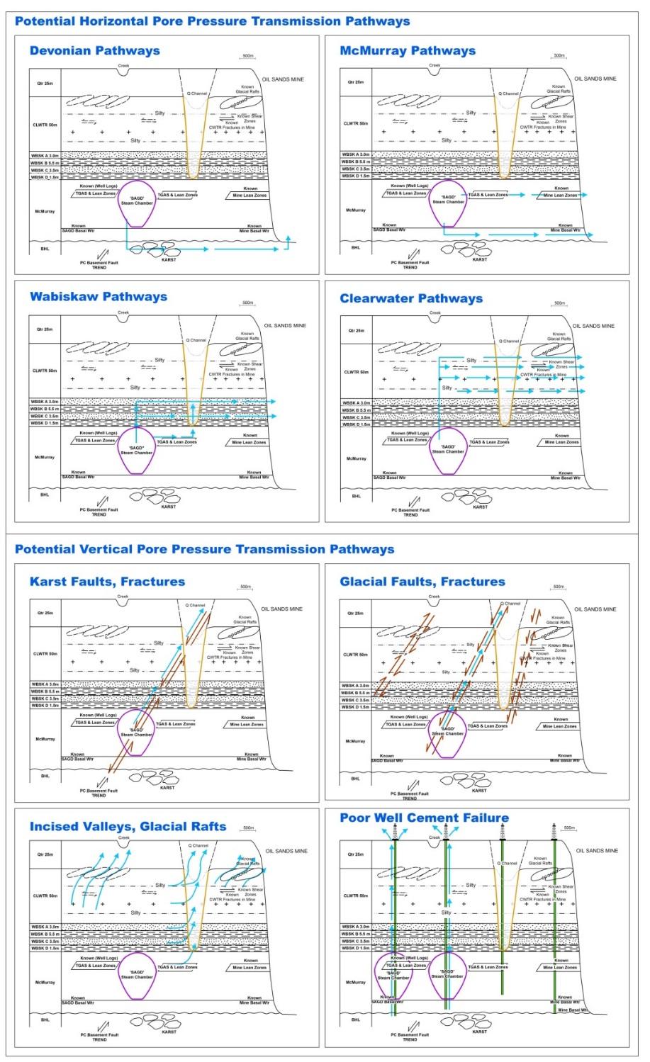
3 Potential intersecting vertical and horizontal pathways of fluid and pressure transmission can be investigated when assessing caprock seal criterion for SAGD operations. See Figure 3. Potential horizontal transmission pathways to be considered include: Devonian: Where the BHL is faulted, fractured or brecciated it has the potential to transmit pore pressure and Devonian fluids horizontally through the Devonian and vertically into the overlying McMurray Formation. McMurray Formation; through the Basal McMurray Aquifer (BMA), through mobile fluids within the bitumen pay, and through bitumen lean deposits saturated with gas and water in the upper part of the McMurray Formation. Wabiskaw Member: through the laterally continuous Wabiskaw C sand and the laterally continuous Wabiskaw A sand. Clearwater Formation: along silty sands and sands in the coarsening-up parasequences above the T31, T51 and T61 transgressive surfaces of erosion. Potential vertical transmission pathways to be considered include: Faults and fractures in the Devonian Beaverhill Lake Group, the McMurray and Clearwater Formations can occur as a strain response to stress originating from normal, thrust and strike slip faults in the Precambrian, from differential rates of evaporite dissolution in the Devonian Elk Point Group and from collapse and karst of overlying Beaverhill Lake carbonates. Faults and fractures in the McMurray and the Clearwater Formations can also occur as a strain response to stress originating from glacial compression, glacial motion and glacial rebound. If they are open to fluid or pressure transmission, the faults and fractures demonstrate a risk to seal integrity of the Clearwater caprock along faulted and fractured planes of weakness. Glacial rafts of dislodged Clearwater shales can occur as a strain response to stress originating from glacial motion. Glacial rafts are commonly observed in the oil sands mining region and can include deposits of Quaternary gravels and cobbles along the base of imbricated rafts. Post Cretaceous incised valleys and tributaries that are filled with Quaternary channel sands and gravels can cut down into the Wabiskaw Member or the McMurray Formation. The sand- and gravel-filled incised valleys can act as vertical pathways of pressure transmission that may intersect with and provide sand-on-sand contact to the horizontal pathways of communication in the progradational sands of the coarsening up parasequences in the Clearwater shale interval and to the fining up transgressive sands of the Wabiskaw C and the Wabiskaw A members. Old wellbores that have not been abandoned to thermal standards can be present in the proximity of SAGD project areas. Old wells have the potential to create vertical pathways of pressure transmission that will intersect with the various horizontal pathways of communication.
4 Conclusions Geologic assessment of SAGD caprock seal capacity, seal geometry and seal integrity is warranted for efficient thermal operations in general and is warranted in particular in the Shallow Thermal Area and in the vicinity of high consequence socio-economic facilities and areas of natural importance. Acknowledgements Suncor Energy Inc., B. King, B. James, S. Stancliffe, J. Fong, B. Raven, J. MacEachern. References Alberta Energy Regulator, Regulatory approach for shallow thermal in situ oil sands applications in the Wabiskaw-McMurray deposit of the Athabasca oil sands area, Bulletin , 3 pp. Cowie, B.R., James, B., and Mayer, B Distribution of total dissolved solids in McMurray Formation water in the Athabasca oil sands region, Alberta, Canada: Implications for regional hydrogeology and resource development. American Association of Petroleum Geologists Bulletin, v.99, p doi: / Kaldi, J.D., and Atkinson, C.D., Seal potential of the Talang Akar Formation, BZZ Area, offshore NW Java, Indonesia. Proceedings Indonesian Petroleum Association, 22 nd Annual Convention, Oct 1993, p IPA Schneider, C.L., and Grobe, M Regional cross-sections of Devonian stratigraphy in northeastern Alberta (NTS 74D, E). Alberta Energy Regulator / Alberta Geological Survey Open File Report , 25 pp.
. Figure 2. Deformation of the Clearwater Formation in the oil sands mining area.")
5 Figure 1. Distribution of total dissolved solids in McMurray Formation waters in the Athabasca oil sands region. The partial dissolution front of the Prairie Evaporite is indicated by red shading. From Cowie et al. (2015). Figure 2. Deformation of the Clearwater Formation in the oil sands mining area. Figure 2a shows deposits of the Clearwater Formation dropped into a graben that is located above a trend of karst features. Figure 2b shows fractures and a regular pattern of jointing in the Clearwater Formation in a pitwall exposure.


6 a. b. Figure 3. Potential horizontal and vertical pathways for pore pressure transmission.
7
Structural Deformation and Karst in the Devonian Waterways Formation: Examples from Outcrops along the Athabasca River*
 Structural Deformation and Karst in the Devonian Waterways Formation: Examples from Outcrops along the Athabasca River* Chris L. Schneider 1 and Matthias Grobe 2 Search and Discovery Article #51073 (2015)
Beneath the Oil Sands: Stratigraphy and Structural Features of the Devonian of Northeast Alberta, Canada*
 Beneath the Oil Sands: Stratigraphy and Structural Features of the Devonian of Northeast Alberta, Canada* Chris L. Schneider 1, Shilong Mei 1, Matthias Grobe 1, and Kristine Haug 1 Search and Discovery
Search and Discovery Article #80372 (2014) Posted May 12, 2014
 Posted May 12, 2014") Paleozoic Stratigraphic Framework beneath the Muskeg River Mine, Northeastern Alberta (Twp 95, Rge 9-10W4): Controls and Constraints on Present Day Hydrogeology* R. Mahood 1, M. Verhoef 1, and F.A. Stoakes
Paleozoic Stratigraphic Framework beneath the Muskeg River Mine, Northeastern Alberta (Twp 95, Rge 9-10W4): Controls and Constraints on Present Day Hydrogeology* R. Mahood 1, M. Verhoef 1, and F.A. Stoakes
Modeling Lateral Accretion in McMurray Formation Fluvial- Estuarine Channel Systems: Grizzly Oil Sands May River SAGD Project, Athabasca
 Modeling Lateral Accretion in McMurray Formation Fluvial- Estuarine Channel Systems: Grizzly Oil Sands May River SAGD Project, Athabasca Duncan Findlay, Thomas Nardin, Alex Wright, Raheleh Salehi Mojarad
Buried Bedrock Channels in the Athabasca Oil Sands Region Conceptual Understanding and Implications to Water Supply
 Buried Bedrock Channels in the Athabasca Oil Sands Region Conceptual Understanding and Implications to Water Supply Scott Rayner Matrix Solutions Inc. Sandra Rosenthal Devon Canada Corporation Presentation
SPE PP. Abstract
 SPE 147302-PP EVALUATION OF THE CLEARWATER FORMATION CAPROCK FOR A PROPOSED, LOW PRESSURE, STEAM-ASSISTED GRAVITY-DRAINAGE PILOT PROJECT IN NORTHEAST ALBERTA M.M.E. Uwiera-Gartner, RPS Energy Canada Ltd.,
Geologic influence on variations in oil and gas production from the Cardium Formation, Ferrier Oilfield, west-central Alberta, Canada
 Geologic influence on variations in oil and gas production from the Cardium Formation, Ferrier Oilfield, west-central Alberta, Canada Marco Venieri and Per Kent Pedersen Department of Geoscience, University
Hydrochemical Assessment of The Devonian Keg River Formation
 Hydrochemical Assessment of The Devonian Keg River Formation Francisco Castrillon-Munoz, MSc., P.Geol. Senior Hydrogeologist Worley Parsons Canada Thinks are not always what they seem MACBETH W. Shakespeare
5 IEAGHG CCS Summer School. Geological storage of carbon dioxide (a simple solution)
") Storage 1- Reservoirs, Traps, Seals and Storage Capacity for Storage Geological storage of carbon dioxide (a simple solution) Professor John Kaldi Chief Scientist, CO2CRC Australian School of Petroleum,
Storage 1- Reservoirs, Traps, Seals and Storage Capacity for Storage Geological storage of carbon dioxide (a simple solution) Professor John Kaldi Chief Scientist, CO2CRC Australian School of Petroleum,
Modeling Lateral Accretion in McMurray Formation Fluvial-Estuarine Channel Systems: Grizzly Oil Sands May River SAGD Project, Athabasca*
 Modeling Lateral Accretion in McMurray Formation Fluvial-Estuarine Channel Systems: Grizzly Oil Sands May River SAGD Project, Athabasca* Duncan Findlay 1, Thomas Nardin 1, Alex Wright 1, and Raheleh Salehi
Lotsberg Salt Formation Solution-mined Cavern for SAGD Solid Waste disposal, Cold Lake, Alberta.
 Lotsberg Salt Formation Solution-mined Cavern for SAGD Solid Waste disposal, Cold Lake, Alberta. Mark Rabin*, Osum Oil Sands, mrabin@osumcorp.com and Piotr Kukialka, Kukialka Consulting Ltd. piotr_kukialka@hotmail.com
GeoCanada 2010 Working with the Earth
 Lithofacies Identification and the Implications for SAGD Well Planning in the McMurray Formation, Christina Lake Area, Alberta Travis Shackleton*, Robert Gardner, Sung Youn, Grace Eng and Lori Barth Cenovus
Investigation of Devonian Unconformity Surface Using Legacy Seismic Profiles, NE Alberta
 Investigation of Devonian Unconformity Surface Using Legacy Seismic Profiles, NE Alberta Elahe P. Ardakani and Douglas R. Schmitt Department of Physics, University of Alberta Summary The Devonian Grosmont
Devonian Petroleum Systems and Exploration Potential, Southern Alberta, Part 3 Core Conference
 Devonian Petroleum Systems and Exploration Potential, Southern Alberta, Part 3 Core Conference Andy Mort (1), Leonard Stevens (2), Richard Wierzbicki (2) Abstract Part 1: Devonian Petroleum Systems Dr.
High-resolution Sequence Stratigraphy of the Glauconitic Sandstone, Upper Mannville C Pool, Cessford Field: a Record of Evolving Accommodation
 Page No. 069-1 High-resolution Sequence Stratigraphy of the Glauconitic Sandstone, Upper Mannville C Pool, Cessford Field: a Record of Evolving Accommodation Thérèse Lynch* and John Hopkins, Department
Carbonates vs Clastics How the Differences Impact our SAGD Assessments. Caralyn Bennett, P. Eng. July 6, 2011
 Carbonates vs Clastics How the Differences Impact our SAGD Assessments Caralyn Bennett, P. Eng. July 6, 2011 Source: Alberta Geological Survey Formations Prospective for Oil Sands Carbonates Clastics
Modeling Lateral Accretion in the McMurray Formation at Grizzly Oil Sands Algar Lake SAGD Project
 Modeling Lateral Accretion in the McMurray Formation at Algar Lake SAGD Project Duncan Findlay 1, Thomas Nardin 1, Andrew Couch 2, Alex Wright 1 1 ULC, 2 EON Introduction Laterally accreting channel systems
Origin and Evolution of Formation Waters in the West-Central Part of the Alberta Basin
 Page No. 004-1 Origin and Evolution of Formation Waters in the West-Central Part of the Alberta Basin Karsten Michael* University of Alberta, 1-26 ESB, Edmonton, AB T6G 2E3 karsten@ualberta.ca and Stefan
Reservoir Geomechanics and Faults
 Reservoir Geomechanics and Faults Dr David McNamara National University of Ireland, Galway david.d.mcnamara@nuigalway.ie @mcnamadd What is a Geological Structure? Geological structures include fractures
Summary. Introduction. Observations and Interpretations
 Lower McMurray Formation sinkholes and their fill fabrics: effects of salt dissolution collapse-subsidence across the northern Athabasca oil sands deposit Paul L. Broughton, Chevron Canada Resources, Calgary,
Summary. Introduction
 Orthogonal geometrics of lower McMurray Formation sand complexes: effects of salt dissolution collapse-subsidence across the northern Athabasca oil sands deposit Paul L. Broughton, Chevron Canada Resources,
Best Practice Reservoir Characterization for the Alberta Oil Sands
 Best Practice Reservoir Characterization for the Alberta Oil Sands Jason A. McLennan and Clayton V. Deutsch Centre for Computational Geostatistics (CCG) Department of Civil and Environmental Engineering
Bulletin of Earth Sciences of Thailand. Evaluation of the Petroleum Systems in the Lanta-Similan Area, Northern Pattani Basin, Gulf of Thailand
 Evaluation of the Petroleum Systems in the Lanta-Similan Area, Northern Pattani Basin, Gulf of Thailand Sirajum Munira Petroleum Geoscience Program, Department of Geology, Faculty of Science, Chulalongkorn
Stress and Strain. Stress is a force per unit area. Strain is a change in size or shape in response to stress
 Geologic Structures Geologic structures are dynamically-produced patterns or arrangements of rock or sediment that result from, and give information about, forces within the Earth Produced as rocks change
Reanalyzing Thermocouple Temperature Response for Evidence of Convective Flow. Mohammad Aghabarati
 Reanalyzing Thermocouple Temperature Response for Evidence of Convective Flow by Mohammad Aghabarati A thesis submitted in partial fulfillment of the requirements for the degree of Master of Science in
Effect on SAGD Performance of Horizontal Well Orientation with Respect to Inclined Shale Layers and Point Bars*
 Effect on SAGD Performance of Horizontal Well Orientation with Respect to Inclined Shale Layers and Point Bars* Amir Zamani 1 and Ron Zakariasen 1 Search and Discovery Article #41334 (2014) Posted May
4D-3C geomechanical study of in-situ bitumen recovery in NW Canada using Toe-to-Heel Air Injection
 4D-3C geomechanical study of in-situ bitumen recovery in NW Canada using Toe-to-Heel Air Injection Kurt Wikel, 1* Rob Kendall, 1 Richard Bale, 2,3 Jeff Grossman 2,4 and Kristof DeMeersman 2 Abstract Recent
- Cased-hole geophysical well logs - Airborne geophysics - Seismic data - LiDAR. GeoConvention 2015: New Horizons 1
 Thermal Effects and Quaternary Hydrogeology: Making Good Decisions in a Complex Geologic Setting Timothy Johnsen, Phd, Quaternary Specialist (tjohnsen@matrix-solutions.com) Alex Haluszka, MSc, P.Geol.,
Facies Analysis of the Lower Cretaceous Wilrich Member (Lower Falher) of the Spirit River Formation.
 of the Spirit River Formation.") Facies Analysis of the Lower Cretaceous Wilrich Member (Lower Falher) of the Spirit River Formation. Kerrie L. Bann, Ichnofacies Analysis Inc. and Daniel J. K. Ross, Tourmaline Oil Corp. Historically,
Facies Analysis of the Lower Cretaceous Wilrich Member (Lower Falher) of the Spirit River Formation. Kerrie L. Bann, Ichnofacies Analysis Inc. and Daniel J. K. Ross, Tourmaline Oil Corp. Historically,
Reactive Transport Model of the Carbonate-Evaporite Elk Point Group Underlying the Athabasca Oil Sands
 Reactive Transport Model of the Carbonate-Evaporite Elk Point Group Underlying the Athabasca Oil Sands Matt Neuner and Skya Fawcett Golder Associates, Canada ABSTRACT A reactive transport model was constructed
Athabasca Oil Sands Corp.
 2011 ABERCB 012 Athabasca Oil Sands Corp. Requests for Interim Shut-in of Gas Liege Field Athabasca Oil Sands Area May 10, 2011 ENERGY RESOURCES CONSERVATION BOARD Decision 2011 ABERCB 012: Athabasca Oil
SASKATCHEWAN STRATIGRAPHY GLACIAL EXAMPLE BOULDERS IN GLACIAL DEPOSITS
 SASKATCHEWAN STRATIGRAPHY GLACIAL EXAMPLE BOULDERS IN GLACIAL DEPOSITS 51 SASKATCHEWAN STRATIGRAPHY GLACIAL SURFICIAL STRATIFIED DEPOSITS 52 SASKATCHEWAN STRATIGRAPHY GLACIAL EXAMPLE OF SEDIMENT DEPOSITION
Case Study of the Structural and Depositional-Evolution Interpretation from Seismic Data*
 Case Study of the Structural and Depositional-Evolution Interpretation from Seismic Data* Yun Ling 1, Xiangyu Guo 1, Jixiang Lin 1, and Desheng Sun 1 Search and Discovery Article #20143 (2012) Posted April
Gas over Bitumen in North Eastern Alberta
 Gas over Bitumen in North Eastern Alberta Was the Alberta Energy and Utility Board s blanket shut-in approach appropriate? Prepared by: Brad Wooley Student ID: 0327273 Professor: Joseph Doucette Class:
AAPG Search and Discovery Article #90173 CSPG/CSEG/CWLS GeoConvention 2011, Calgary, Alberta, Canada, May 9-11, 2011
 Use of Image Logs in Differentiating Point Bar and Tidal Bar Deposits in the Leismer Area: Implications for SAGD Reservoir Definition in the Athabasca Oilsands Howard Brekke and Andrew Couch Introduction
PRIMROSE FLOW TO SURFACE CAUSATION REPORT
 PRIMROSE FLOW TO SURFACE CAUSATION REPORT Report Prepared for: ALBERTA ENERGY REGULATOR AND ALBERTA ENVIRONMENT AND SUSTAINABLE RESOURCE DEVELOPMENT Prepared by: CANADIAN NATURAL RESOURCES LIMITED June
Seismic Reflection Imaging across the Johnson Ranch, Valley County, Idaho
 Seismic Reflection Imaging across the Johnson Ranch, Valley County, Idaho Report Prepared for the Skyline Corporation Lee M. Liberty Center for Geophysical Investigation of the Shallow Subsurface (CGISS)
LOWER GRAND RAPIDS BITUMEN POOLS AT COLD LAKE, ALBERTA VARIATIONS IN STRATIGRAPHIC SETTING AND DEPOSITIONAL ENVIRONMENTS
 RAPIDS BITUMEN POOLS AT COLD LAKE, ALBERTA VARIATIONS IN STRATIGRAPHIC SETTING AND DEPOSITIONAL ENVIRONMENTS Brad J. Hayes, Petrel Robertson Consulting Ltd. Garrett M. Quinn, OSUM Oil Sands Corp. Summary
https://gsa.confex.com/gsa/2014am/webprogram/paper html
 Abstract: IMPACT OF PALEOZOIC KARST UPON GROUNDWATER FLOW IN TH... https://gsa.confex.com/gsa/2014am/webprogram/paper244571.html Page 1 of 1 28/08/2014 Start Author Index Meeting Information Paper No.
Geomechanical controls on fault and fracture distribution with application to structural permeability and hydraulic stimulation
 CSPG Luncheon Calgary February 5 th 2015 Geomechanical controls on fault and fracture distribution with application to structural permeability and hydraulic stimulation Scott Mildren - Ikon Science Australian
HYDROGEOLOGICAL PROPERTIES OF THE UG2 PYROXENITE AQUIFERS OF THE BUSHVELD COMPLEX
 R. Gebrekristos, P.Cheshire HYDROGEOLOGICAL PROPERTIES OF THE UG2 PYROXENITE AQUIFERS OF THE BUSHVELD COMPLEX R. Gebrekristos Digby Wells Environmental P. Cheshire Groundwater Monitoring Services Abstract
Simplified In-Situ Stress Properties in Fractured Reservoir Models. Tim Wynn AGR-TRACS
 Simplified In-Situ Stress Properties in Fractured Reservoir Models Tim Wynn AGR-TRACS Before the What and the How is Why Potential decrease in fault seal capacity Potential increase in natural fracture
Pros and Cons against Reasonable Development of Unconventional Energy Resources
 Pros and Cons against Reasonable Development of Unconventional Energy Resources Associate Professor Shteryo LYOMOV, Ph.D. Presentation outline Energy resources; Conventional and Unconventional energy resources;
PRECAMBRIAN CRYSTALLINE AQUIFER (METAMORPHIC ROCKS)
") HAYWARD QUADRANGLE: Groundwater Production by Aquifer In the 56-square-mile area of the Hayward Quadrangle, groundwater is produced from metamorphic crystalline rocks of the Precambrian basement (in the
HAYWARD QUADRANGLE: Groundwater Production by Aquifer In the 56-square-mile area of the Hayward Quadrangle, groundwater is produced from metamorphic crystalline rocks of the Precambrian basement (in the
Geophysical Exploration in Water Resources Assessment. John Mundell, P.E., L.P.G., P.G. Ryan Brumbaugh, L.P.G. Mundell & Associates, Inc.
 Geophysical Exploration in Water Resources Assessment John Mundell, P.E., L.P.G., P.G. Ryan Brumbaugh, L.P.G. Mundell & Associates, Inc. Presentation Objective Introduce the use of geophysical survey methods
Tu D Understanding the Interplay of Fractures, Stresses & Facies in Unconventional Reservoirs - Case Study from Chad Granites
 Tu D201 04 Understanding the Interplay of Fractures, Stresses & Facies in Unconventional Reservoirs - Case Study from Chad Granites D. Lirong (Chinese National Petroleum Company Ltd. (Chad)), C. Shrivastava*
Structural Style in the Peel Region, NWT and Yukon
 Structural Style in the Peel Region, NWT and Yukon Adriana Taborda* Husky Energy and University of Calgary, Calgary, AB Adriana.Taborda@huskyenergy.ca and Deborah Spratt University of Calgary, Calgary,
Buried Bedrock Channels in the Athabasca Oil Sands Region Conceptual Understanding and Implications to Water Supply
 Buried Bedrock Channels in the Athabasca Oil Sands Region Conceptual Understanding and Implications to Water Supply Scott Rayner 1 and Sandra Rosenthal 2 1 Matrix Solutions Inc. 118, 319 2nd Ave. SW, Calgary
Practical Geomechanics
 www.bakerhughes.com Practical Geomechanics Baker Hughes - RDS Geomechanics Services 2015 Baker Hughes Incorporated. All rights reserved Copyright By accepting these materials you agree that all materials
Answers: Internal Processes and Structures (Isostasy)
") Answers: Internal Processes and Structures (Isostasy) 1. Analyse the adjustment of the crust to changes in loads associated with volcanism, mountain building, erosion, and glaciation by using the concept
Answers: Internal Processes and Structures (Isostasy) 1. Analyse the adjustment of the crust to changes in loads associated with volcanism, mountain building, erosion, and glaciation by using the concept
Distinguished Lecturer David A. Ferrill. Sponsored by AAPG Foundation
 Distinguished Lecturer David A. Ferrill Sponsored by AAPG Foundation AAPG Membership Information Benefits: Monthly Receipt of AAPG Explorer & AAPG Bulletin Discounts on Books and Other Publications Registration
The Sequence Stratigraphic and Paleogeograhic Distribution of Reservoir-Quality Dolomite, Madison Formation, Wyoming and Montana
 The Sequence Stratigraphic and Paleogeograhic Distribution of Reservoir-Quality Dolomite, Madison Formation, Wyoming and Montana TAURY SMITH AND GREGOR EBERLI The primary aim of this study is to show the
MESOZOIC BASINS. North Carolina Geological Survey
 MESOZOIC BASINS North Carolina Geological Survey The 1823 organic act which created the North Carolina Geological Survey (NCGS) tasked us to examine, describe and map the geology, geologic hazards, and
Lower Skinner Valley Fill Sandstones: Attractive Exploration Targets on the Northeast Oklahoma Platform*
 Lower Skinner Valley Fill Sandstones: Attractive Exploration Targets on the Northeast Oklahoma Platform* By Jim Puckette 1 Search and Discovery Article #10050 (2003) *Adapted from presentation to Tulsa
Critical Borehole Orientations Rock Mechanics Aspects
 Critical Borehole Orientations Rock Mechanics Aspects By R. BRAUN* Abstract This article discusses rock mechanics aspects of the relationship between borehole stability and borehole orientation. Two kinds
Sediment and sedimentary rocks Sediment
 Sediment and sedimentary rocks Sediment From sediments to sedimentary rocks (transportation, deposition, preservation and lithification) Types of sedimentary rocks (clastic, chemical and organic) Sedimentary
Overview of Selected Shale Plays in New Mexico*
 Overview of Selected Shale Plays in New Mexico* Ron Broadhead 1 Search and Discovery Article #10627 (2014)** Posted August 18, 2014 *Adapted from presentation at RMAG luncheon meeting, Denver, Colorado,
Kinematic inversion of pre-existing faults by wastewater injection-related induced seismicity: the Val d Agri oil field case study (Italy)
") Kinematic inversion of pre-existing faults by wastewater injection-related induced seismicity: the Val d Agri oil field case study (Italy) Buttinelli M., Improta L., Bagh S., Chiarabba C. 1/10 The Val
Kinematic inversion of pre-existing faults by wastewater injection-related induced seismicity: the Val d Agri oil field case study (Italy) Buttinelli M., Improta L., Bagh S., Chiarabba C. 1/10 The Val
Crags, Cracks, and Crumples: Crustal Deformation and Mountain Building
 Crags, Cracks, and Crumples: Crustal Deformation and Mountain Building Updated by: Rick Oches, Professor of Geology & Environmental Sciences Bentley University Waltham, Massachusetts Based on slides prepared
Chapter 15 Structures
 Chapter 15 Structures Plummer/McGeary/Carlson (c) The McGraw-Hill Companies, Inc. TECTONIC FORCES AT WORK Stress & Strain Stress Strain Compressive stress Shortening strain Tensional stress stretching
Instituto De Ingenieros De Minas Del Peru
 The Continuity Challenge Dr. Wayne Barnett The Interpretation! Great geological continuity? Huge potential? The Reality Not what it might seem... Not what it might seem... Presentation Objective Highlight
Quaternary clays alluvial sands of the Shepparton Formation overlie the basement rocks.
 NAGAMBIE GOLDFIELD Regional Geological Setting The Nagambie Project is located within the Melbourne Structural Zone of Victoria. The lithologies range in age from the Upper Silurian Broadford Formation
Fred Mayer 1; Graham Cain 1; Carmen Dumitrescu 2; (1) Devon Canada; (2) Terra-IQ Ltd. Summary
 Devon Canada; (2) Terra-IQ Ltd. Summary") 2401377 Statistically Improved Resistivity and Density Estimation From Multicomponent Seismic Data: Case Study from the Lower Cretaceous McMurray Formation, Athabasca Oil Sands Fred Mayer 1; Graham Cain
2401377 Statistically Improved Resistivity and Density Estimation From Multicomponent Seismic Data: Case Study from the Lower Cretaceous McMurray Formation, Athabasca Oil Sands Fred Mayer 1; Graham Cain
NAME HOMEWORK ASSIGNMENT #3 MATERIAL COVERS CHAPTERS 8, 9, 10, 11
 NAME HOMEWORK ASSIGNMENT #3 MATERIAL OVERS HAPTERS 8, 9, 10, 11 Assignment is due the beginning of the class period on November 23, 2004. Answers for each chapter will be discussed in class, as Exam #3
Glauconitic Oil Reservoirs in Southern Alberta Creating the Correct Geological Model to Guide Development Drilling
 Glauconitic Oil Reservoirs in Southern Alberta Creating the Correct Geological Model to Guide Development Drilling Brad Hayes* Petrel Robertson Consulting Ltd, Calgary, AB bhayes@petrelrob.com Lisa Griffith
Dr. Kenneth B. Taylor, P.G.
 North Carolina Forestry Association 2013 Annual Meeting October 3, 2013 Shale Gas 101: Natural Gas Exploration / Development: A North Carolina Perspective presented by Dr. Kenneth B. Taylor, P.G. State
The Stability Of Fault Systems In The South Shore Of The. St. Lawrence Lowlands Of Québec Implications For Shale Gas Development
 The Stability Of Fault Systems In The South Shore Of The St. Lawrence Lowlands Of Québec Implications For Shale Gas Development John Brodylo, Jean-Yves Chatellier,Guillaume Matton & Michel Rheault Copyright
Evidence Linking Surface Lineaments, Deep-Seated Faults and Fracture-Controlled Fluid Movement in the Williston Basin
 Evidence Linking Surface Lineaments, Deep-Seated Faults and Fracture-Controlled Fluid Movement in the Williston Basin Lynden Penner J.D. Mollard and Associates Limited Regina, SK Canada 14 th Williston
American Institute of Professional Geologists South Dakota Section
 American Institute of Professional Geologists South Dakota Section 2015 Field Trip Guide Deadwood Formation in the Black Hills of South Dakota and Frac Sand Potential Saturday, September 12, 2015 1 Field
Exploration Significance of Unconformity Structure on Subtle Pools. 1 Vertical structure characteristics of unconformity
 Exploration Significance of Unconformity Structure on Subtle Pools Wu Kongyou (China University of Petroleum,College of Geo-Resources and Information,Shandong Qingdao 266555) Abstract: Vertical structure
Integrating Geomechanics and Reservoir Characterization Examples from Canadian Shale Plays
 Integrating Geomechanics and Reservoir Characterization Examples from Canadian Shale Plays AAPG Geosciences Technology Workshops Geomechanics and Reservoir Characterization of Shale and Carbonates July
Detecting fractures using time-lapse 3C-3D seismic data
 data Zimin Zhang, Don C. Lawton and Robert R. Stewart ABSTRACT This report presents the interpretation of time-lapse 3C-3D seismic data for fracture detection in a Saskatchewan potash mine. Seismic interpretation
Fracture, Fluid Flow and Diagenetic History of the Arbuckle Group
 Fracture, Fluid Flow and Diagenetic History of the Arbuckle Group Robert H. Goldstein, Evan K. Franseen, W. Lynn Watney, Bradley King STATUS: Focused-term near completion, year 3 of 3 TIMING: Began August
Characterizing Seal Bypass Systems at the Rock Springs Uplift, Southwest Wyoming, Using Seismic Attribute Analysis*
 Characterizing Seal Bypass Systems at the Rock Springs Uplift, Southwest Wyoming, Using Seismic Attribute Analysis* Yuri Ganshin 1 and Fred McLaughlin 1 Search and Discovery Article #80483 (2015)** Posted
Ladyfern, N.E.B.C.: Major Gas Discovery in the Devonian Slave Point Formation
 Page No. 112-1 Ladyfern, N.E.B.C.: Major Gas Discovery in the Devonian Slave Point Formation Thomas Boreen and Kelvin Colquhoun, Apache Canada Ltd., Calgary, Alberta ABSTRACT The Upper Devonian Slave Point
Faults. Strike-slip fault. Normal fault. Thrust fault
 Faults Strike-slip fault Normal fault Thrust fault Fault any surface or narrow zone with visible shear displacement along the zone Normal fault Strike-slip fault Reverse fault Thrust fault
URTeC: Abstract
 URTeC: 2902950 Can Seismic Inversion Be Used for Geomechanics? A Casing Deformation Example Jeremy J. Meyer 1*, Jeremy Gallop 1, Alvin Chen 1, Scott Reynolds 1, Scott Mildren 1 ; 1. Ikon Science Copyright
PROCEEDINGS, INDONESIAN PETROLEUM ASSOCIATION Thirty-Ninth Annual Convention and Exhibition, May 2015
 IPA15-SG-089 PROCEEDINGS, INDONESIAN PETROLEUM ASSOCIATION Thirty-Ninth Annual Convention and Exhibition, May 2015 STRUCTURAL INTERPRETATION OF TECTONICALLY ASSOCIATED NORMAL AND REVERSE FAULTS OF BUKIT
The Eocene Gir Formation of the Ghani and Ed Dib Fields, Eastern Libya - an example of "Virtual Core Study"
 The Eocene Gir Formation of the Ghani and Ed Dib Fields, Eastern Libya - an example of "Virtual Core Study" Henry Williams*, Suncor Energy Inc., Calgary, AB hwilliams@suncor.com Summary The Gir Formation
Grand Rapids Oil Sands 3D Seismic Incorporating and Comparing Multiple Data Types for Reservoir Characterization
 Grand Rapids Oil Sands 3D Seismic Incorporating and Comparing Multiple Data Types for Reservoir Characterization Laurie M. Weston Bellman* Oil Sands Imaging Inc., Calgary, Alberta laurie@oilsandsimaging.com
Time-lapse seismic modelling for Pikes Peak field
 Time-lapse seismic modelling for Pikes Peak field Ying Zou*, Laurence R. Bentley and Laurence R. Lines University of Calgary, 2500 University Dr, NW, Calgary, AB, T2N 1N4 zou@geo.ucalgary.ca ABSTRACT Predicting
The Impact of Parasequence Stacking Patterns on Vertical Connectivity Between Wave-Dominated, Shallow Marine Parasequences, Book Cliffs, Eastern Utah
 The Impact of Parasequence Stacking Patterns on Vertical Connectivity Between Wave-Dominated, Shallow Marine Parasequences, Book Cliffs, Eastern Utah MALCOLM J. ARNOT and TIMOTHY R. GOOD* MALCOLM J. ARNOT
Quantitative evaluation of fault lateral sealing
 IOSR Journal of Engineering (IOSRJEN) ISSN (e): 2250-3021, ISSN (p): 2278-8719 Vol. 06, Issue 03 (March. 2016), V1 PP 29-33 www.iosrjen.org Jianan Zhu 1, Yue Gong 1 1 (College of Earth Sciences, Northeast
Storage 6 - Modeling for CO 2 Storage. Professor John Kaldi Chief Scientist, CO2CRC Australian School of Petroleum, University of Adelaide, Australia
 Storage 6 - Modeling for CO 2 Storage Professor John Kaldi Chief Scientist, CO2CRC Australian School of Petroleum, University of Adelaide, Australia Regina, Sask., Canada, 17-22 July, 2016 Modeling 2 What
11/22/2010. Groundwater in Unconsolidated Deposits. Alluvial (fluvial) deposits. - consist of gravel, sand, silt and clay
 deposits. - consist of gravel, sand, silt and clay") Groundwater in Unconsolidated Deposits Alluvial (fluvial) deposits - consist of gravel, sand, silt and clay - laid down by physical processes in rivers and flood plains - major sources for water supplies
Groundwater in Unconsolidated Deposits Alluvial (fluvial) deposits - consist of gravel, sand, silt and clay - laid down by physical processes in rivers and flood plains - major sources for water supplies
Structural Geology of the Mountains
 Structural Geology of the Mountains Clinton R. Tippett Shell Canada Limited, Calgary, Alberta clinton.tippett@shell.ca INTRODUCTION The Southern Rocky Mountains of Canada (Figure 1) are made up of several
ractical Geomechanics for Unconventional Resources
 P ractical Geomechanics for Unconventional Resources 24-26 October 2012, Calgary, Canada Practical Geomechanics for Unconventional Resources Nowadays, unconventional resources have been brought into the
Controls on facies distributions in the Charlie Lake Formation, Peace River Arch, Alberta
 Controls on facies distributions in the Charlie Lake Formation, Peace River Arch, Alberta E.L. Percy 12, C. Frostad 2, A. Juska 2, C. Schmidt 2, C. Sitzler 2, and J.P. Zonneveld 3 University of Calgary,
We LHR1 01 The Influence of Pore Pressure in Assessing Hydrocarbon Prospectivity - A Review
 We LHR1 01 The Influence of Pore Pressure in Assessing Hydrocarbon Prospectivity - A Review S. Green (Ikon Science), S.A. O'Connor (Ikon Science) & A.P. Edwards* (Ikon Science) SUMMARY Assessing the prospectivity
Laboratory experiments and numerical simulation on Bitumen Saturated Carbonates: A Rock Physics Study for 4D Seismology
 Laboratory experiments and numerical simulation on Bitumen Saturated Carbonates: A Rock Physics Study for 4D Seismology Arif Rabbani Jason Nycz* Zizhen Wong Doug Schmitt Ken Gray Department of Physics
 12 10 8 6 4 2 0 40-50 50-60 60-70 70-80 80-90 90-100 Fresh Water What we will cover The Hydrologic Cycle River systems Floods Groundwater Caves and Karst Topography Hot springs Distribution of water in
Introduction. Milovan Fustic 1, Rudy Strobl 1, Bryce Jablonski 1, Torgrim Jacobsen 2, Eirik Vik 2, and Allard W. Martinius 1
 McMurray Formation Type Section Outcrop: Part 1 - a world class learning lab for fluvio - tidal sedimentology, petroleum systems and reservoir characterization & Part 2 an unparalleled portal for SAGD
KANSAS GEOLOGICAL SURVEY Open File Report LAND SUBSIDENCE KIOWA COUNTY, KANSAS. May 2, 2007
 KANSAS GEOLOGICAL SURVEY Open File Report 2007-22 LAND SUBSIDENCE KIOWA COUNTY, KANSAS Prepared by Michael T. Dealy L.G., Manager, Wichita Operations SITE LOCATION The site was approximately four miles
The Clearwater Formation: A Facies Study for SAGD Water Source in the Athabasca Oil Sands
 The Clearwater Formation: A Facies Study for SAGD Water Source in the Athabasca Oil Sands Wallace, J. and Lavigne, J Introduction Water source has become an increasingly important issue recently with the
Apply Rock Mechanics in Reservoir Characterization Msc Julio W. Poquioma
 Apply Rock Mechanics in Reservoir Characterization Msc Julio W. Poquioma Chief Reservoir Engineer PetroSA Mobil: +27 79 492.02.52 Email julio.poquioma@petrosa.co.za Aberdeen, April 18 20 / 2012 Content
Risk Evaluation. Todd Shipman PhD, Alberta Geological Survey/Alberta Energy Regulator November 17 th,2017 Induced Seismicity Workshop, Yellowknife NWT
 Risk Evaluation Todd Shipman PhD, Alberta Geological Survey/Alberta Energy Regulator November 17 th,2017 Induced Seismicity Workshop, Yellowknife NWT Risk Management Approach to Induced Seismicity Establishing
Sequence Stratigraphy of the Upper Cretaceous Niobrara Formation, A Bench, Wattenberg Field, Denver Julesburg Basin, Colorado*
 Sequence Stratigraphy of the Upper Cretaceous Niobrara Formation, A Bench, Wattenberg Field, Denver Julesburg Basin, Colorado* Lisa E. Remington LaChance 1 and Mark C. Robinson 1 Search and Discovery Article
Core Technology for Evaluating the Bakken
 Core Technology for Evaluating the Bakken Fundamentals for Reservoir Quality Assessment and Completion Analysis John Kieschnick and Roberto Suarez-Rivera TerraTek 1 Topics Covered Core Technology Changes
ractical Geomechanics for Oil & Gas Industry
 P ractical Geomechanics for Oil & Gas Industry Practical Geomechanics for Oil and Gas Industry The integrity of the wellbore plays an important role in petroleum operations including drilling, completion
Basin Analysis Applied to Modelling Buried Valleys in the Great Lakes Basin
 EARTH SCIENCES SECTOR GENERAL INFORMATION PRODUCT 35 Basin Analysis Applied to Modelling Buried Valleys in the Great Lakes Basin Sharpe, D R; Russell, H A J 2004 Originally released as: Basin Analysis