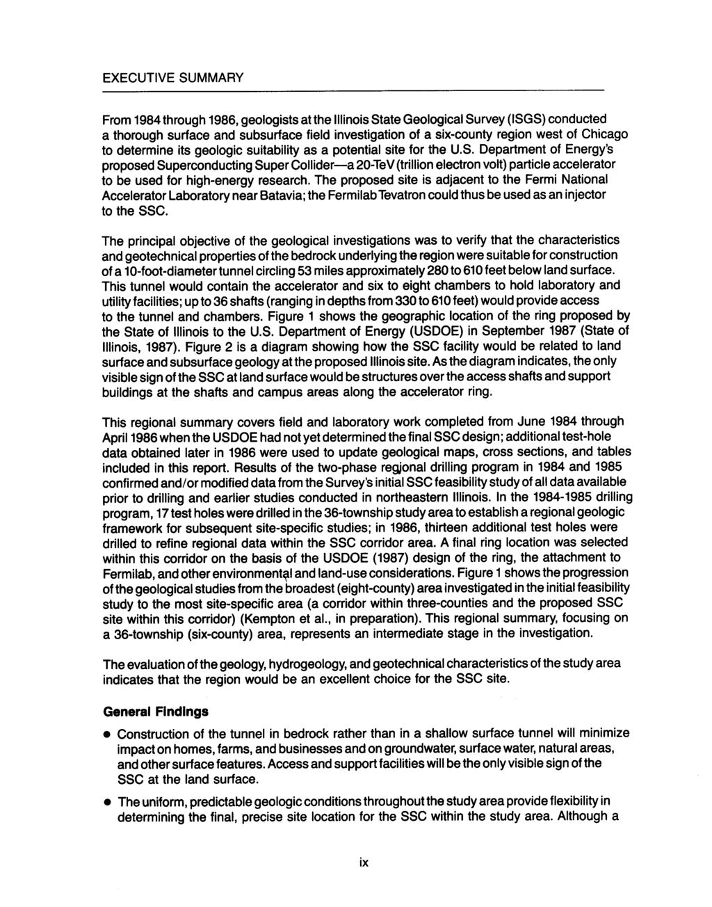
iii CONTENTS vii ACKNOWLEDGMENTS EXECUTIVE SUMMARY INTRODUCTION Study Area Data Sources Preparation of Geologic Maps
|
|
|
- Sharleen Jacobs
- 5 years ago
- Views:
Transcription
1
2
3
4
5 CONTENTS ACKNOWLEDGMENTS EXECUTIVE SUMMARY INTRODUCTION Study Area Data Sources Preparation of Geologic Maps GEOLOGY Bedrock Geology Succession and Distribution Structural Features Description of Bedrock Units Bedrock Topography and Characteristics of the Bedrock Surface Glacial Drift and Surficial Deposits Succession, Distribution, and Thickness Description of Units Surficial Features HYDROGEOLOGY Regional Hydrogeologic Setting Hydrostratigraphic Units Classification Glacial Drift Upper Bedrock Aquifer Upper Ordovician Aquitard Midwest Sandstone Aquifers Hydraulic Conductivity Glacial Drift Bedrock Potentiometric Levels Water Levels in Aquifers Water Levels in Aquitards Groundwater Resources Glacial Drift Bedrock GEOTECHNICAL PROPERTIES OF GEOLOGIC UNITS Glacial Drift Richland or Peoria Loess Equality Formation Wedron Formation Sangamon Soil-Robein Silt Glasford Formation Bedrock-Drift Interface Bedrock General Characteristics Joint Characteristics vii ix iii
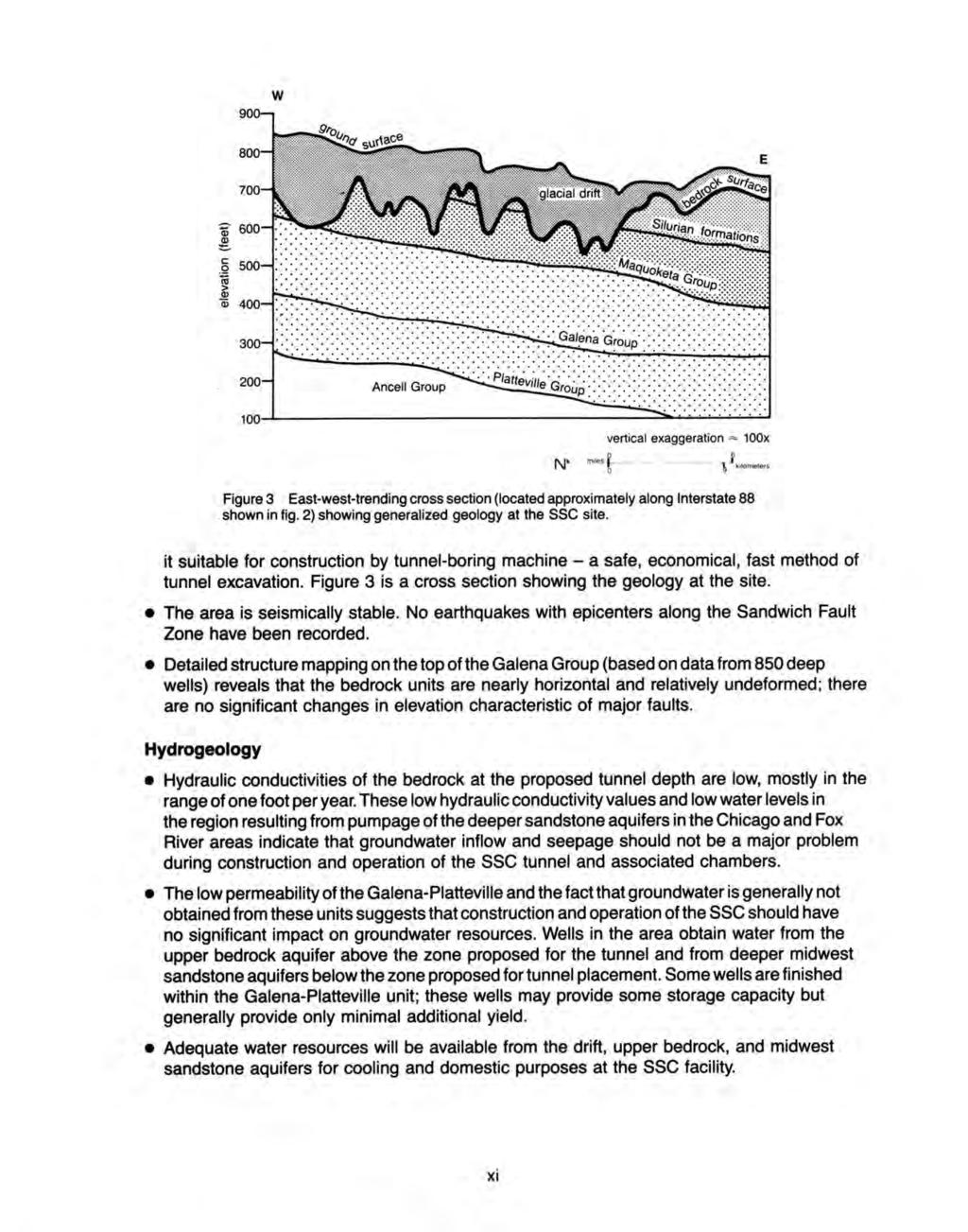
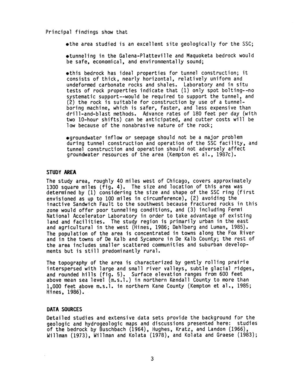
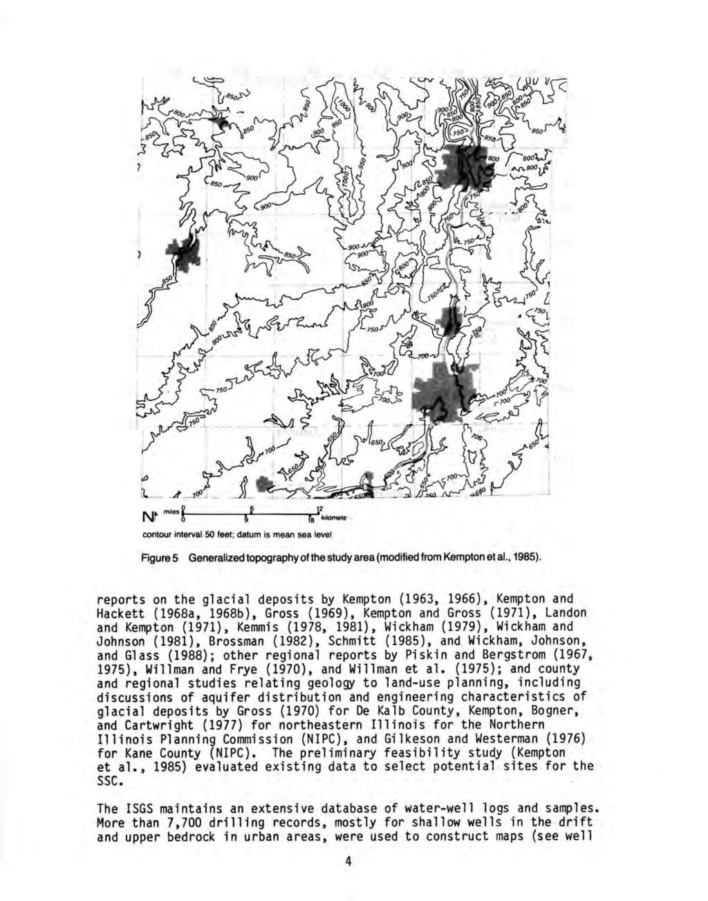
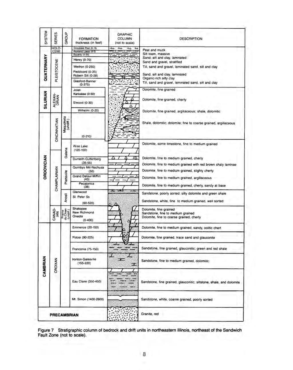
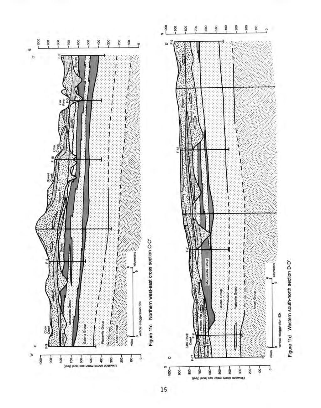
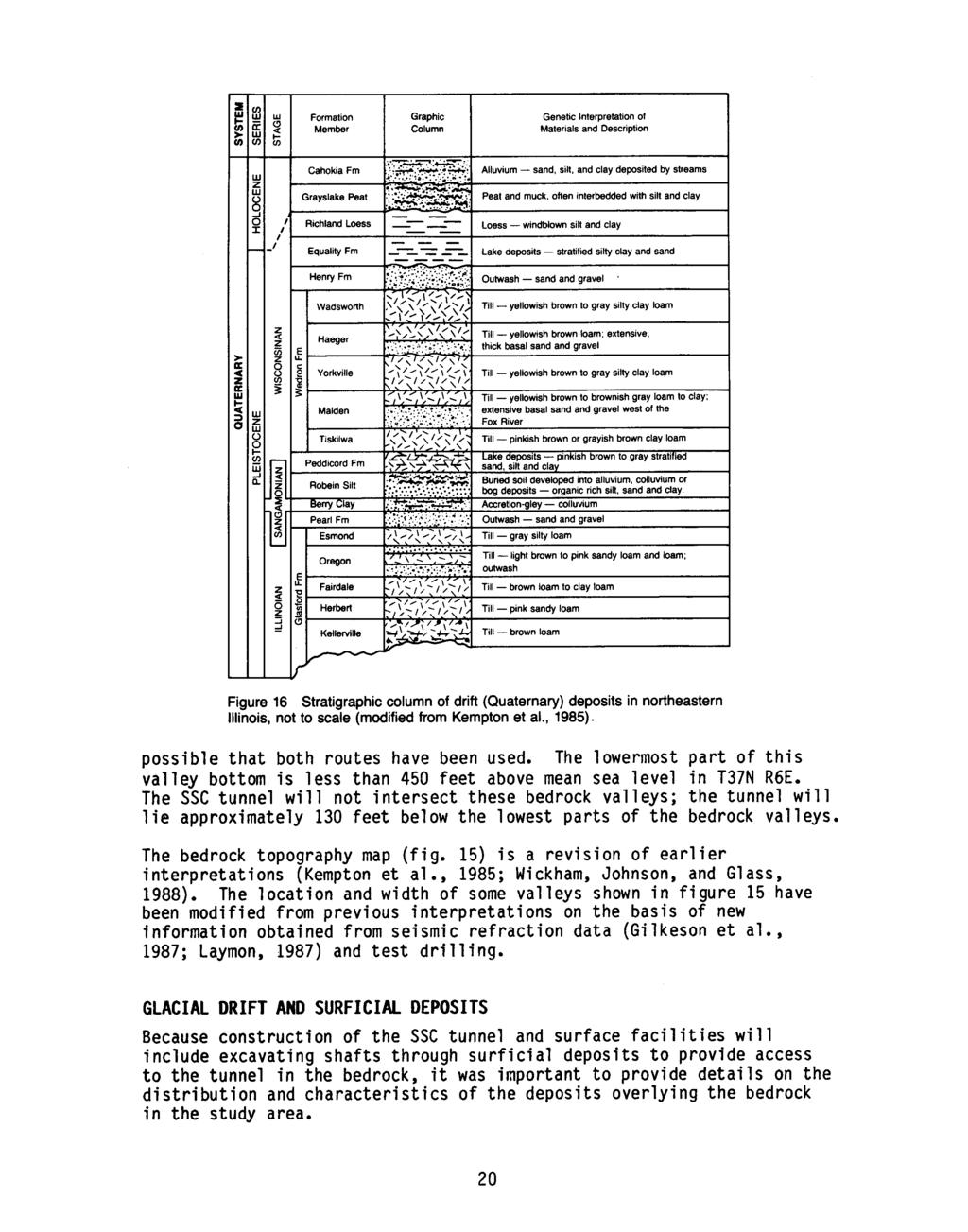
6 EVALUATION OF CONSTRUCTION CONDITIONS 61 Tunnel Construction 61 Rock Mass Quality and Support 61 Excavation Methods 62 Shaft Construction 64 Chamber Construction 66 Seismicity and Man-Made Vibrations 66 Potential Uses of Excavated Rock Material 70 Tunnel Inflow Estimates 70 SUMMARY AND CONCLUSIONS 73 Geology 74 Hydrogeology 75 Geotechnical Properties of Geologic Units 76 Evaluation of Construction Conditions 77 GLOSSARY 79 REFERENCES ~ APPEND~ES ~ A. Geotechnical Properties 91 B. Laboratory Procedures 93 C. Geotechnical Data for ISGS Test Holes F-1 through F Figures 1 Study area in northeastern Illinois, showing one possible ring configuration for the SSC tunnel and the sequence of areas studied since 1983 viii 2 Cut-away of area proposed for SSC location x 3 East-west trending cross section showing generalized geology at the SSC site xi 4 Map of study area showing townships, selected towns, streams, test-boring locations, ~nd one possible ring configuration for the SSC tunnel 2 5 Generalized topography of the study area 4 6 Major structural features in northeastern Illinois as indicated by the elevation of the top of the Franconia Formation in the Cambrian System 6 7 Stratigraphic column of bedrock and drift units in northeastern Illinois 8 8 Areal geology of the bedrock surface 9 9 Structure on the top of the Galena Group Structure on the top of the Ancell Group 11 11a Southern west-east cross section A-A' b Eastern south-north cross section B-8' 14 11c Northern west-east cross section C-C' 15 11d Western south-north section 0-0' Combined thickness of the Galena and Platteville Groups Thickness of the Maquoketa Group Thickness of the Silurian formations Bedrock topography 19 iv

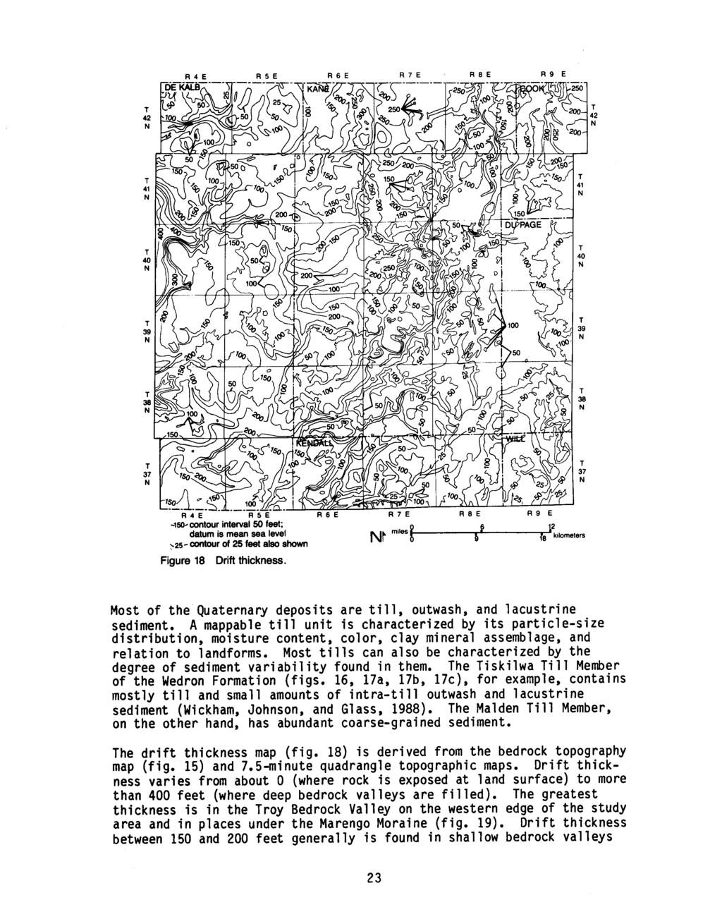
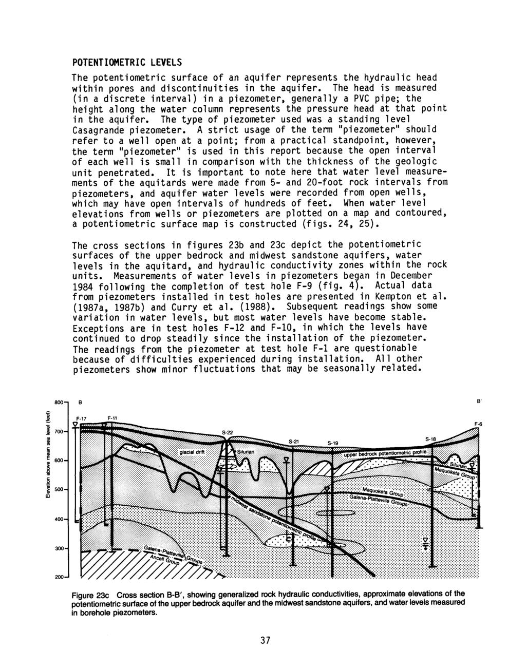
7 16 Stratigraphic column of drift deposits in northeastern Illinois 20 17a Location map for drift cross sections and drill hole locations 21 17b Cross section of glacial drift showing lithostratigraphic units from west to east 22 17c Cross section of glacial drift showing lithostratigraphic units from north to south Drift thickness Locations of moraines Surficial drift map Comparison of formal hydrostratigraphic units and informal classification used in this study Potential drift aquifers 32 23a. Map of bedrock surface showing locations of hydrogeologic cross sections 34 23b Cross section A-A', showing generalized rock hydraulic conductivities, approximate elevations of the potentiometric surface of the upper bedrock aquifer and the midwest sandstone aquifers, and water levels measured in piezometers 36 23c Cross section B-B', showing generalized rock hydraulic conductivities, approximate elevations of the potentiometric surface of the upper bedrock aquifer and the midwest sandstone aquifers, and water levels measured in piezometers Potentiometric surface of the upper bedrock aquifer Potentiometric surface of the midwest sandstone aquifers 39 26a Moisture content of the Yorkville Till Member, Wedron Formation 46 26b N (blow count) values for the Yorkville Till Member 47 26c Unconfined compressive strength of the Yorkville Till Member 48 27a Moisture content of the Tiskilwa Till Member, Wedron Formation 49 27b Unconfined compressive strength of the Tiskilwa Till Member 49 27c N (blow count) values for the Tiskilwa Till Member Quarries and sand and gravel pits noted in text 52 29a Strength test data for Silurian and Maquoketa bedrock samples, showing compressive strength and modulus ratios 54 29b Strength test data for Galena and Platteville samples, showing compressive strength and modulus ratios Slake durability values for Maquoketa samples 56 31a Joint set direction rosette diagram for Podschwit Quarry 58 31b Joint set direction rosette diagram for SSC exploratory borehole F a Joint dip per formation/group for boreholes F-1 through F b Filling in joints per formation/group for boreholes F-1 through F c Joint roughness per formation/group for boreholes F-1 through F Evaluation of construction conditions in Galena-Platteville and Maquoketa bedrock, obtained by Barton's Q-classification System for estimating support requirements Muir-Wood diagram indicating tunneling conditions and appropriate tunneling methods in bedrock Map showing epicenters and dates of earthquakes in northern Illinois Seismic risk map of the United States Map showing horizontal acceleration in bedrock expressed as percentage of gravity 69 B-1 Mohr-Coulomb failure envelope defined by three triaxial strength tests showing cohesive strength and phi angle 95 v
8 Tables 1 Summary of hydraulic conductivity values of rock and drift aquifer units 35 2 Groundwater pumpage by county in Summary of geotechnical characteristics and properties of the drift 44 4 Groupings of approximate bearing strengths of glacial materials 50 5 Summary of geotechnical conditions at or near the bedrock surface 53 6 Average rock property values and in situ conditions 56 7 Barton's O-Rock Mass Classification System 63 8 Bieniawski's Rock Mass Rating (RMR) for most probable conditions 63 9 Earthquakes with epicenters in and outside northern Illinois Thresholds of damage from particle velocities 69 C-1 Drilling rates 97 C-2 Average core recovery values 97 C-3 Lowest core recovery values 98 C-4 Average ROD values 98 C-5 Lowest ROD values 98 C-6 Summary of rock mechanics data 99 C-7 Triaxial test results 100 vi
9
10
11

12
13
14
15
16
17
18
19
20
21
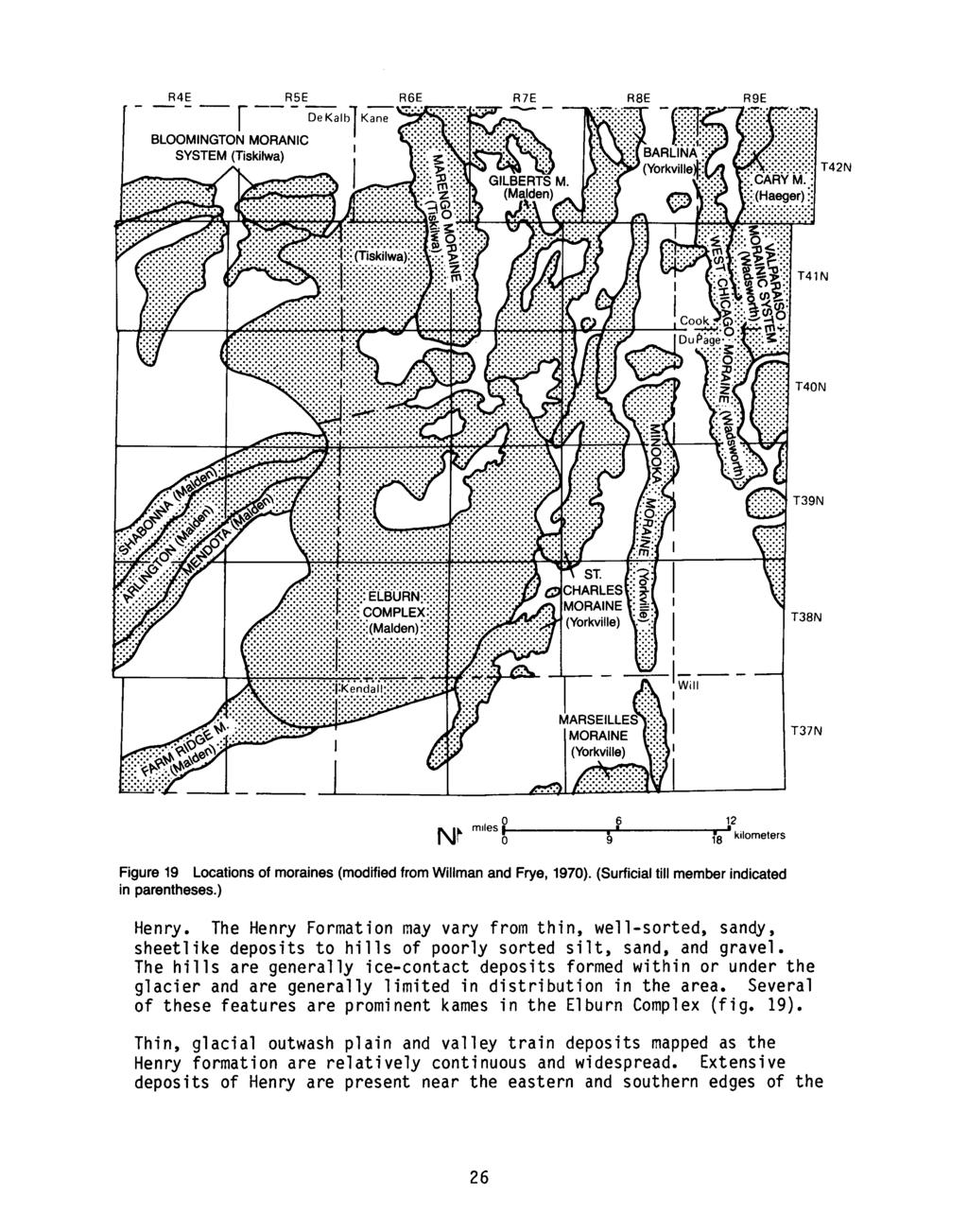
22
23
24
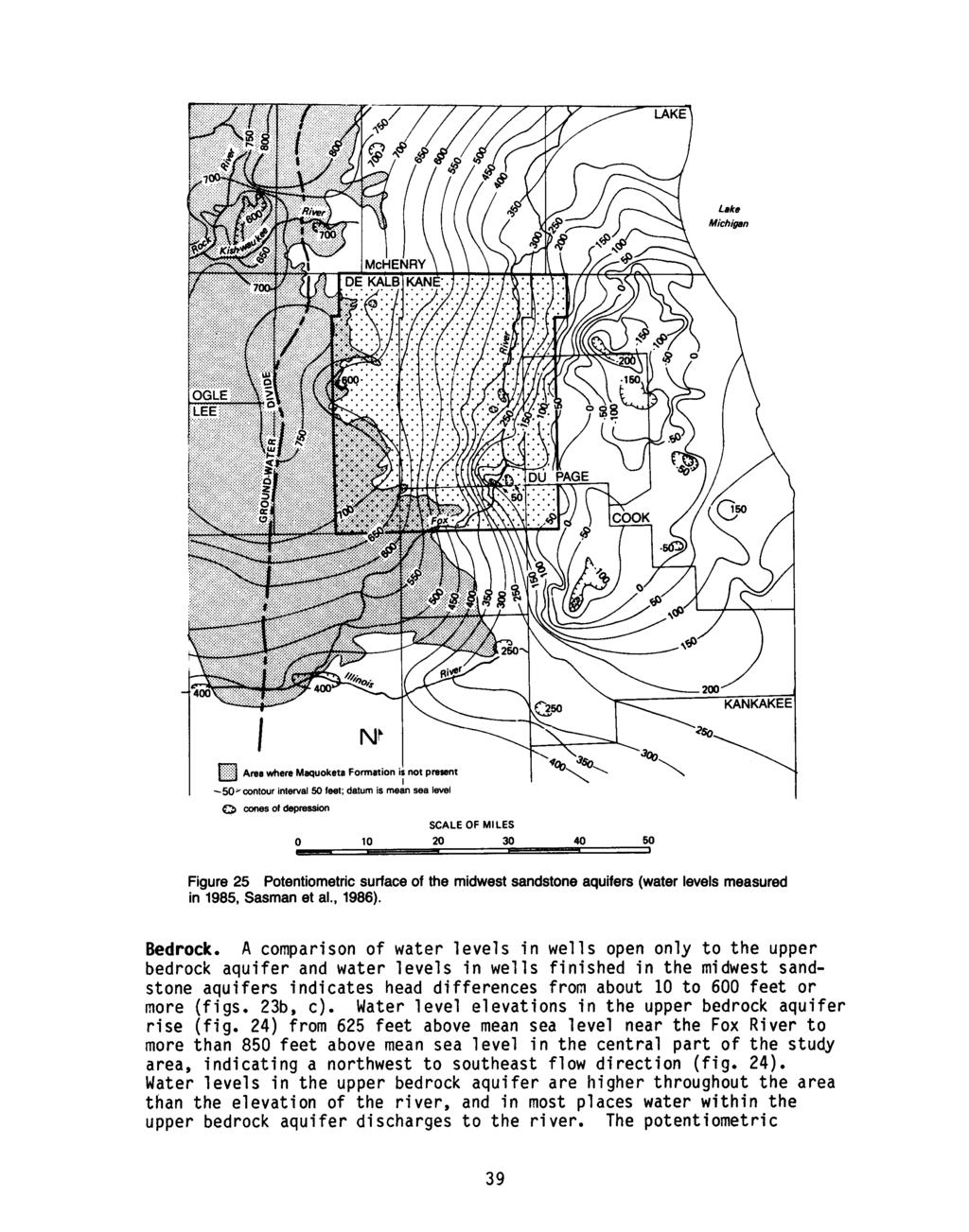
25
26
27
28
29
30
31
32
33
34
35
36
37
38
39
40
41
42
43
44
45
46
47
48
49
50
51
52
53
54
55
56
57
58
59
60
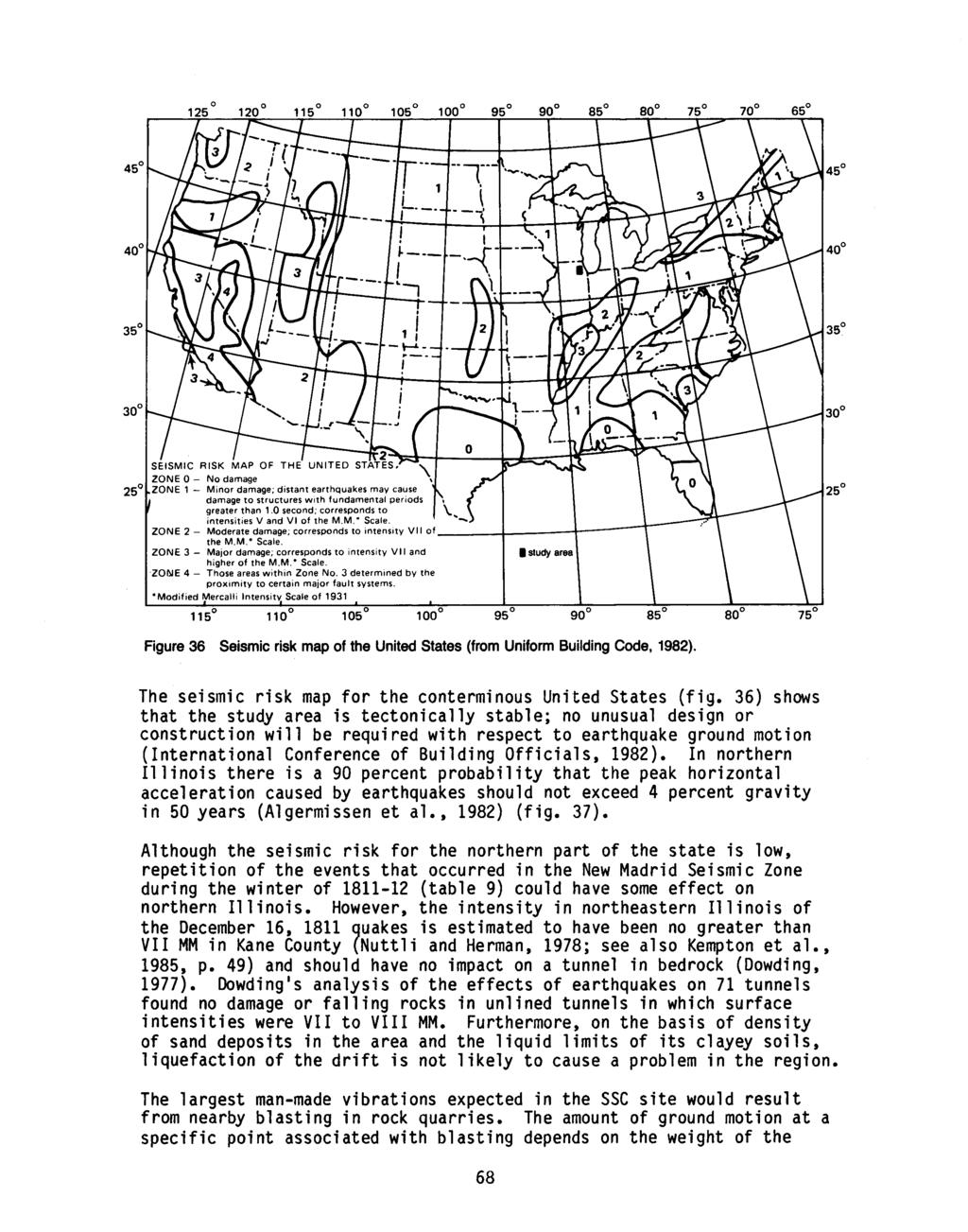
61
62
63
64
65
66
67
68
69
70
71
72
73
74
75
76
77
78
79
80
81
82
83
84
85
86
87
88
89
90
91
92
93
94
95
96
97
98
99
100
101
102
103
104
105
106
107
108
109
110
111
112
113
114
115

116
117
NEAR THE VILLAGE OF NORTH AURORA, ILLINOIS RESULTS OF A SHALLOW SEISMIC REFRACTION SURVEY. Timothy H. Larson. QsuJk Sa^^oJ^M. Philip G.
 557 IL6of 1991-15 QsuJk Sa^^oJ^M RESULTS OF A SHALLOW SEISMIC REFRACTION SURVEY NEAR THE VILLAGE OF NORTH AURORA, ILLINOIS Timothy H. Larson Philip G. Orozco Open File Series 1991-15 ILLINOIS STATE GEOLOGICAL
ILLINOIS GROUNDWATER - BEDROCK
 ILLINOIS GROUNDWATER - BEDROCK Northern Illinois Fresh Water Water Supply Shallow Bedrock Aquifers < 500 depth Deep Bedrock Aquifers > 500 depth Southern Illinois Saline water Oil Fracking Coal Waste injection
10. GEOTECHNICAL EXPLORATION PROGRAM
 Geotechnical site investigations should be conducted in multiple phases to obtain data for use during the planning and design of the tunnel system. Geotechnical investigations typically are performed in
Ground-Water Investigations for Siting the Superconducting Super Collider in Northeastern Illinois
 ISWS/CIR-170/88 Circular 170 STATE OF ILLINOIS DEPARTMENT OF ENERGY AND NATURAL RESOURCES Ground-Water Investigations for Siting the Superconducting Super Collider in Northeastern Illinois by ADRIAN P.
Rock Mechanics and Seismology Laboratory
 CAEE 211 Geology Laboratory 6 Lab Date: 29 July 2016 Rock Mechanics and Seismology Laboratory Due Date: 5 August 2016 Attendance (based on signing): 30 points Submitting Student Name: Members of laboratory
Chapter 12 Subsurface Exploration
 Page 12 1 Chapter 12 Subsurface Exploration 1. The process of identifying the layers of deposits that underlie a proposed structure and their physical characteristics is generally referred to as (a) subsurface
Urbana-Champaign. University of Illinois. Digitized by the Internet Archive
 JUN 1 2 1997 Digitized by the Internet Archive in 2012 with funding from University of Illinois Urbana-Champaign http://archive.org/details/geotechnicalprop139baue ih.gs EGN 139 Geotechnical Properties
MEMORANDUM SUBJECT: CERTIFICATE IN ROCK MECHANICS PAPER 1 : THEORY SUBJECT CODE: COMRMC MODERATOR: H YILMAZ EXAMINATION DATE: OCTOBER 2017 TIME:
 MEMORANDUM SUBJECT: CERTIFICATE IN ROCK MECHANICS PAPER 1 : THEORY EXAMINER: WM BESTER SUBJECT CODE: COMRMC EXAMINATION DATE: OCTOBER 2017 TIME: MODERATOR: H YILMAZ TOTAL MARKS: [100] PASS MARK: (60%)
fregonruleco. 1 U.S.A. 2
 3 5 fregonruleco. 1 U.S.A. 2 557.09773 IL6cr 1985-1 Qojl ^^\ ISGS CONTRACT/GRANT REPORT 1985-1 GEOPHYSICAL STUDIES AT THE SHEFFIELD LOW-LEVEL RADIOACTIVE WASTE DISPOSAL FACILITY TO EVALUATE POTENTIAL PATHWAYS
Boreholes. Implementation. Boring. Boreholes may be excavated by one of these methods: 1. Auger Boring 2. Wash Boring 3.
 Implementation Boreholes 1. Auger Boring 2. Wash Boring 3. Rotary Drilling Boring Boreholes may be excavated by one of these methods: 4. Percussion Drilling The right choice of method depends on: Ground
Uf^S^O^LM. Hydrogeology of Shallow Groundwater Resources Geneva-Batavia Township, Kane County, Illinois. Stephen S. McFadden. Timothy H.
 Uf^S^O^LM v Hydrogeology of Shallow Groundwater Resources Geneva-Batavia Township, Kane County, Illinois Timothy H. Larson Stephen S. McFadden Robert H. Gilkeson f Open File Series 1992-5 ILLINOIS STATE
Green River Lowland and
 EG 149 14.GS: EGN 149 c. 3 (X^JL^uu^-j Hydrogeology of the Green River Lowland and Associated Bedrock Valleys in Northwestern Illinois David R. Larson Beverly L. Herzog Robert C. Vaiden Cheri A. Chenoweth
SASKATCHEWAN STRATIGRAPHY GLACIAL EXAMPLE BOULDERS IN GLACIAL DEPOSITS
 SASKATCHEWAN STRATIGRAPHY GLACIAL EXAMPLE BOULDERS IN GLACIAL DEPOSITS 51 SASKATCHEWAN STRATIGRAPHY GLACIAL SURFICIAL STRATIFIED DEPOSITS 52 SASKATCHEWAN STRATIGRAPHY GLACIAL EXAMPLE OF SEDIMENT DEPOSITION
SHALLOW GROUNDWATER RESOURCES
 3GS CONTRACT/GRANT REPORT: 1989-1 SHALLOW GROUNDWATER RESOURCES ASSESSMENT FOR THE VILLAGE OF MONTGOMERY, ILLINOIS Stephen S. McFadden, Craig R. Gendron, and Faith A. Stanke Technical Completion Report
Surficial Geologic Mapping Proposal for STATEMAP FY2019
 Surficial Geologic Mapping Proposal for STATEMAP FY2019 presented by David Grimley Illinois State Geological Survey Prairie Research Institute, University of Illinois IGMAC meeting, September 6 th, 2018
Kane County Water Resources Investigations:
 Contract Report 2007-06 Kane County Water Resources Investigations: Final Report on Shallow Aquifer Potentiometric Surface Mapping Randall A. Locke II, P.G. and Scott C. Meyer, P.G. by Prepared for the
Geological Mapping using Geophysics
 Geological Mapping using Geophysics Pugin, A.J.M. and T.H. Larson Illinois State Geological Survey, 615 E Peabody Dr., Champaign, IL 61820; E-mail: A.J.M. Pugin at pugin@isgs.uiuc.edu Mapping Techniques.
The Geology and Hydrogeology of the Spyhill Area
 The Geology and Hydrogeology of the Spyhill Area Clare North (WorleyParsons Komex) and Martin Ortiz (The City of Calgary) 2-Jul-08 Outline Background Site Location Existing Information New Work Geology
Chapter 8 Fetter, Applied Hydrology 4 th Edition, Geology of Groundwater Occurrence
 Chapter 8 Fetter, Applied Hydrology 4 th Edition, 2001 Geology of Groundwater Occurrence Figure 8.42. Alluvial Valleys ground-water region. Fetter, Applied Hydrology 4 th Edition, 2001 Fetter, Applied
Gotechnical Investigations and Sampling
 Gotechnical Investigations and Sampling Amit Prashant Indian Institute of Technology Gandhinagar Short Course on Geotechnical Investigations for Structural Engineering 12 14 October, 2017 1 Purpose of
HYDROGEOLOGICAL PROPERTIES OF THE UG2 PYROXENITE AQUIFERS OF THE BUSHVELD COMPLEX
 R. Gebrekristos, P.Cheshire HYDROGEOLOGICAL PROPERTIES OF THE UG2 PYROXENITE AQUIFERS OF THE BUSHVELD COMPLEX R. Gebrekristos Digby Wells Environmental P. Cheshire Groundwater Monitoring Services Abstract
Finding Large Capacity Groundwater Supplies for Irrigation
 Finding Large Capacity Groundwater Supplies for Irrigation December 14, 2012 Presented by: Michael L. Chapman, Jr., PG Irrigation Well Site Evaluation Background Investigation Identify Hydrogeologic Conditions
Geophysical Site Investigation (Seismic methods) Amit Prashant Indian Institute of Technology Gandhinagar
 Amit Prashant Indian Institute of Technology Gandhinagar") Geophysical Site Investigation (Seismic methods) Amit Prashant Indian Institute of Technology Gandhinagar Short Course on Geotechnical Aspects of Earthquake Engineering 04 08 March, 2013 Seismic Waves
Geophysical Site Investigation (Seismic methods) Amit Prashant Indian Institute of Technology Gandhinagar Short Course on Geotechnical Aspects of Earthquake Engineering 04 08 March, 2013 Seismic Waves
A surficial. P^HiHI waste disposal site, Bureau County, Illinois. east of the Sheffield low-level radioactive. electrical resistivity survey
 ISGS CONTRACT/GRANT REPORT 1981-6 WATER RESOURCES DIVISION/USGS P^HiHI 100240 557.09773 IL6cr 1981-6 A surficial electrical resistivity survey east of the Sheffield low-level radioactive waste disposal
IAEA SAFETY STANDARDS Geotechnical Aspects of Site Evaluation and Foundations in NPPs, NS-G-3.6
 IAEA SAFETY STANDARDS Geotechnical Aspects of Site Evaluation and Foundations in NPPs, NS-G-3.6 Regional Workshop on Volcanic, Seismic, and Tsunami Hazard Assessment Related to NPP Siting Activities and
KDOT Geotechnical Manual Edition. Table of Contents
 KDOT Geotechnical Manual 2007 Edition The KDOT Geotechnical Manual is available two volumes. Both volumes are very large electronic (pdf) files which may take several minutes to download. The table of
A Risk-based Groundwater Modelling Study for Predicting Thermal Plume Migration from SAGD Well-pads
 A Risk-based Groundwater Modelling Study for Predicting Thermal Plume Migration from SAGD Well-pads Rudy Maji, Ph.D., Golder Associates Solaleh Khezri, M.Sc., AB Scientific Intern (Golder Associates) Don
Manual on Subsurface Investigations National Highway Institute Publication No. FHWA NHI Federal Highway Administration Washington, DC
 Manual on Subsurface Investigations National Highway Institute Publication No. FHWA NHI-01-031 Federal Highway Administration Washington, DC Geotechnical Site Characterization July 2001 by Paul W. Mayne,
Appendix 6 Geotechnical report
 Page 56 Appendix 6 Geotechnical report 1. Introduction The following provides an initial and preliminary description/assessment of the overall geology, the likely ground conditions and preliminary geotechnical
Subsurface Geology of the Kennebec River
 Maine Geologic Facts and Localities July, 1998 Subsurface Geology of the Kennebec River 43 54 40.75 N, 69 48 29.01 W Text by Daniel B. Locke, Department of Agriculture, Conservation & Forestry 1 Map by
FUNDAMENTALS OF ENGINEERING GEOLOGY
 FUNDAMENTALS OF ENGINEERING GEOLOGY Prof. Dr. HUSSEIN HAMEED KARIM Building and Construction Engineering Department 2012 Preface The impulse to write this book stemmed from a course of geology given by
SCOPE OF INVESTIGATION Simple visual examination of soil at the surface or from shallow test pits. Detailed study of soil and groundwater to a
 Lecture-5 Soil Exploration Dr. Attaullah Shah 1 Today s Lecture Purpose of Soil Exploration Different methods 1. Test trenches and Pits 2. Auger and Wash Boring 3. Rotary Drilling 4. Geophysical Methods
ENGINEERING GEOLOGY AND ROCK ENGINEERING
 1 ENGINEERING GEOLOGY AND ROCK ENGINEERING HANDBOOK NO. 2 Norwegian Group for Rock Mechanics (NBG) www.bergmekanikk.com Prepared in co-operation with Norwegian Tunnelling Society (NFF) Issued in 2000 SECRETARIAT:
Underground Risk Management Course Marina Del Rey, California November, Geotechnical Data Reports. Greg Raines, PE
 Underground Risk Management Course Marina Del Rey, California November, 2018 Geotechnical Data Reports Greg Raines, PE Gregory.Raines@Stantec.com Introduction What is a Geotechnical Data Report? The GDR
Slope Stability Evaluation Ground Anchor Construction Area White Point Landslide San Pedro District Los Angeles, California.
 Slope Stability Evaluation Ground Anchor Construction Area White Point Landslide San Pedro District Los Angeles, California Submitted To: Mr. Gene Edwards City of Los Angeles Department of Public Works
Buried-valley Aquifers: Delineation and Characterization from Reflection Seismic and Core Data at Caledon East, Ontario
 Buried-valley Aquifers: Delineation and Characterization from Reflection Seismic and Core Data at Caledon East, Ontario Russell, H.A.J. 1, S.E. Pullan 1, J.A. Hunter 1, D.R. Sharpe 1, and S. Holysh 2 1
Site Investigations and Geotechnical Risk For Underground Construction Greg Raines, PE
 August 14, 2017 Site Investigations and Geotechnical Risk For Underground Construction Greg Raines, PE Gregory.Raines@Stantec.com Develop Preliminary Geologic / Geotech Conceptual Model for the Project
Final Technical Report COLLECTION, COMPILATION AND ANALYSIS OF GEOLOGIC AND GEOTECHNICAL DATA FOR MAP PRODUCTION
 Final Technical Report COLLECTION, COMPILATION AND ANALYSIS OF GEOLOGIC AND GEOTECHNICAL DATA FOR MAP PRODUCTION External Grant Award Number 99-HQ-GR-0086 Robert A. Bauer, Coordinator CUSEC State Geologists,
A method for three-dimensional mapping, merging geologic interpretation, and GIS computation
 A method for three-dimensional mapping, merging geologic interpretation, and GIS computation Soller, David R., U.S. Geological Survey, 908 National Center, Reston, VA 20192 and Richard C. Berg, Illinois
Surficial Geology of Oak Hill Quadrangle
 Illinois Preliminary Geologic Map IPGM Oak Hill-SG Surficial Geology of Oak Hill Quadrangle Peoria County, Illinois François Hardy and C. Pius Weibel 2008 ILLINOIS STATE GEOLOGICAL SURVEY E. Donald McKay
Delineation of Zones at Risk from Groundwater Inflows at an Underground Platinum Mine in South Africa
 Delineation of Zones at Risk from Groundwater Inflows at an Underground Platinum Mine in South Africa Mr Andreas Stoll andreas.stoll@erm.com Environmental Resources Management Swiss GmbH (ERM), Switzerland
GUIDELINES FOR OPEN PIT SLOPE DESIGN EDITORS: JOHN READ, PETER STACEY # & CSIRO. J x PUBLISHING
 GUIDELINES FOR OPEN PIT SLOPE DESIGN EDITORS: JOHN READ, PETER STACEY # & CSIRO J x PUBLISHING S Contents Preface and acknowledgments xiii 1 Fundamentals of slope design 1 Peter Stacey 1.1 Introduction
Surficial Geology of Dunlap Quadrangle
 Illinois Preliminary Geologic Map IPGM Dunlap-SG Surficial Geology of Dunlap Quadrangle Peoria County, Illinois François Hardy and C. Pius Weibel 2008 ILLINOIS STATE GEOLOGICAL SURVEY E. Donald McKay III,
Larson, David R. GEOLOGIC, GEOPHYSICAL, AND HYDROLOGIC INVESTIGATIONS FOR A SUPPLEMENTAL MUNICIPAL GROUNDWATER SUPPLY,
 ISWS COOP18 Loan c.1 98062215 Larson, David R. GEOLOGIC, GEOPHYSICAL, AND HYDROLOGIC INVESTIGATIONS FOR A SUPPLEMENTAL MUNICIPAL GROUNDWATER SUPPLY, ISWS COOP18 Loan c.1 98062215 Larson, David R. GEOLOGIC,
Groundwater in Bayfield County
 Groundwater in Bayfield County Presented to Bayfield County Large Scale Livestoc Study Committee April 23, 2015 Madeline Gotowitz Hydrogeologist Groundwater in Bayfield County Groundwater basics Hydrogeology
CK-UNIT MAPPING OF GEOLOGIC MATERIALS IN ILLINOIS TO A DEPTH OF 15 METERS
 s 14.GS: CIR 542 c.4 - CK-UNIT MAPPING OF GEOLOGIC MATERIALS IN ILLINOIS TO A DEPTH OF 15 METERS llun.ots GEOLOGICAL survey LIBRARY r Richard C. Berg and John P. Kempton ILLINOIS STATE GEOLOGICAL SURVEY
General Geologic Setting and Seismicity of the FHWA Project Site in the New Madrid Seismic Zone
 General Geologic Setting and Seismicity of the FHWA Project Site in the New Madrid Seismic Zone David Hoffman University of Missouri Rolla Natural Hazards Mitigation Institute Civil, Architectural & Environmental
Geotechnical & Mining Engineering Services
 Geotechnical & Mining Engineering Services Southwest Research Institute San Antonio, Texas A s an independent, nonprofit research and development organization, Southwest Research Institute (SwRI ) uses
ontribution of Geotechnical and Rock echanics design to vertical shaft nking and design
 ontribution of Geotechnical and Rock echanics design to vertical shaft nking and design CONTENTS Geological and Geotechnical investigations Pre-sink Examples of Pre-sinking in soft soils Ancillary excavations
Evolution of the conceptual hydrogeologic and ground-water flow model for Las Vegas Valley, Clark County, Nevada
 Evolution of the conceptual hydrogeologic and ground-water flow model for Las Vegas Valley, Clark County, Nevada Geological Society of America Annual Meeting November 14, 2 David J. Donovan Southern Nevada
In situ fracturing mechanics stress measurements to improve underground quarry stability analyses
 In situ fracturing mechanics stress measurements to improve underground quarry stability analyses Anna M. Ferrero, Maria R. Migliazza, Andrea Segalini University of Parma, Italy Gian P. Giani University
Geophysical Exploration in Water Resources Assessment. John Mundell, P.E., L.P.G., P.G. Ryan Brumbaugh, L.P.G. Mundell & Associates, Inc.
 Geophysical Exploration in Water Resources Assessment John Mundell, P.E., L.P.G., P.G. Ryan Brumbaugh, L.P.G. Mundell & Associates, Inc. Presentation Objective Introduce the use of geophysical survey methods
7. Foundation and Slope Stability
 The Asian Nuclear Safety Network 7. Foundation and Slope Stability (SER 2.5.4 & 2.5.5) Taek-Mo SHIM k147stm@kins.re.kr Korea Institute of Nuclear Safety Structural Systems and Site Evaluation Department
Project Area. Funded by the Illinois Department of Transportation Springfield, Illinois
 Three-dimensional Geologic Mapping for Transportation Planning in Central-northern northern Illinois: Data Selection, Map Construction, and Model Development Richard C. Berg, E. Donald McKay, Donald A.
Engineer. Engineering. Engineering. (in-ja-neer ) A person trained and skilled in any of the various branches of engineering: a civil engineer
 A person trained and skilled in any of the various branches of engineering: a civil engineer") Engineer (in-ja-neer ) A person trained and skilled in any of the various branches of engineering: a civil engineer (Random House Webster s College Dictionary, 1991) CE100 Introduction to Civil Geotechnical
Engineer (in-ja-neer ) A person trained and skilled in any of the various branches of engineering: a civil engineer (Random House Webster s College Dictionary, 1991) CE100 Introduction to Civil Geotechnical
Groundwater Geology of DeKalb County, Illinois with Emphasis on the Troy Bedrock Valley
 C 563 Groundwater Geology of DeKalb County, Illinois with Emphasis on the Troy Bedrock Valley Robert C. Vaiden, Edward C. Smith, and Timothy H. Larson Circular 563 4 Illinois Department of Natural Resources
the Quarrying Industry Dewatering and the Quarrying Industry the Quarrying Industry
 Dewatering and the Quarrying Industry Dewatering and Dewatering and the Quarrying Industry the Quarrying Industry Les Brown Eugene P. Daly John Kelly Objectives 1) To present a summary of water management
Surficial Geology of Henry County, Illinois
 Illinois County Geologic Map ICGM Henry-SG Surficial Geology of Henry County, Illinois Richard C. Anderson and Xiaodong Miao 2011 Prairie Research Institute ILLINOIS STATE GEOLOGICAL SURVEY 615 East Peabody
ON THE FACE STABILITY OF TUNNELS IN WEAK ROCKS
 33 rd 33 Annual rd Annual General General Conference conference of the Canadian of the Canadian Society for Society Civil Engineering for Civil Engineering 33 e Congrès général annuel de la Société canadienne
Geologic Mapping in Northeastern Illinois. What do we know about. Donald A. Keefer, Director Geologic Mapping and Hydrogeology Center
 Geologic Mapping in Northeastern Illinois & What do we know about Lake County s Geology? Donald A. Keefer, Director Geologic Mapping and Hydrogeology Center Societal Benefits of Mapping Water Supply Delineation,
Groundwater Hydrology
 EXERCISE 12 Groundwater Hydrology INTRODUCTION Groundwater is an important component of the hydrologic cycle. It feeds lakes, rivers, wetlands, and reservoirs; it supplies water for domestic, municipal,
SITE INVESTIGATION 1
 SITE INVESTIGATION 1 Definition The process of determining the layers of natural soil deposits that will underlie a proposed structure and their physical properties is generally referred to as site investigation.
Activity Submitted by Tim Schroeder, Bennington College,
 Structural Analysis of a Hot Dry Rock Geothermal Energy System Activity Submitted by Tim Schroeder, Bennington College, tschroeder@bennington.edu Description: This project applies basic geologic skills
Rock slope rock wedge stability
 Engineering manual No. 28 Updated: 02/2018 Rock slope rock wedge stability Program: Rock stability File: Demo_manual_28.gsk The aim of the chapter of this engineering manual is to explain a rock slope
Instructional Objectives
 GE 6477 DISCONTINUOUS ROCK 8. Fracture Detection Dr. Norbert H. Maerz Missouri University of Science and Technology (573) 341-6714 norbert@mst.edu Instructional Objectives 1. List the advantages and disadvantages
June 9, R. D. Cook, P.Eng. Soils Engineer Special Services Western Region PUBLIC WORKS CANADA WESTERN REGION REPORT ON
 PUBLIC WORKS CANADA WESTERN REGION REPORT ON GEOTECHNICAL INVESTIGATION PROPOSED MARTIN RIVER BRIDGE MILE 306.7 MACKENZIE HIGHWAY Submitted by : R. D. Cook, P.Eng. Soils Engineer Special Services Western
Geological and geotechnical approach for excavation of large unlined rock cavern
 Geological and geotechnical approach for excavation of large unlined rock cavern D. Singh, A. Mandal*, A. Usmani and A. Nanda The degree of uncertainty involved in an underground storage project is relatively
How to Identify and Properly Classify Drill Cuttings
 How to Identify and Properly Classify Drill Cuttings (Creating Useful Borehole Logs) Dave Larson Hydrogeology and Geophysics Section Accurate information about the borehole location and a careful description
Instructional Objectives. Why use mass classification? What is rock mass classification? 3 Pillars of empirical design and rock mass classification
 GE 6477 DISCONTINUOUS ROCK 5. Rock Mass Classification and Empirical Design Dr. Norbert H. Maerz Missouri University of Science and Technology (573) 341-6714 norbert@mst.edu Instructional Objectives 1.
Aquitard Characterization The Legend of Indiana s Magic Clay Layer. Juliet Port, LPG #2214 July 2014
 Aquitard Characterization The Legend of Indiana s Magic Clay Layer Juliet Port, LPG #2214 July 2014 Topics What is an Aquitard? Why do we care? Review of Indiana glacial geology Conceptual Framework Investigation
Changing Groundwater Levels in the Sandstone Aquifers of Northern Illinois and Southern Wisconsin: Impacts on Available Water Supply
 Contract Report 2015-02 Changing Groundwater Levels in the Sandstone Aquifers of Northern Illinois and Southern Wisconsin: Impacts on Available Water Supply Daniel B. Abrams, Daniel R. Hadley, Devin H.
Excavation method in Goushfill mine
 International Journal of Engineering and Technology, 2 (3) (2013) 225-229 Science Publishing Corporation www.sciencepubco.com/index.php/ijet Excavation method in Goushfill mine Masoud Cheraghi Seifabad*,
SHEAR STRENGTH OF SOIL
 Soil Failure Criteria SHEAR STRENGTH OF SOIL Knowledge about the shear strength of soil important for the analysis of: Bearing capacity of foundations, Slope stability, Lateral pressure on retaining structures,
PRINCIPLES OF GEOTECHNICAL ENGINEERING
 PRINCIPLES OF GEOTECHNICAL ENGINEERING Fourth Edition BRAJA M. DAS California State University, Sacramento I(T)P Boston Albany Bonn Cincinnati London Madrid Melbourne Mexico City New York Paris San Francisco
Guidelines for Site-Specific Seismic Hazard Reports for Essential and Hazardous Facilities and Major and Special-Occupancy Structures in Oregon
 Guidelines for Site-Specific Seismic Hazard Reports for Essential and Hazardous Facilities and Major and Special-Occupancy Structures in Oregon By the Oregon Board of Geologist Examiners and the Oregon
Project S4: ITALIAN STRONG MOTION DATA BASE. Deliverable # D3. Definition of the standard format to prepare descriptive monographs of ITACA stations
 Agreement INGV-DPC 2007-2009 Project S4: ITALIAN STRONG MOTION DATA BASE Responsibles: Francesca Pacor, INGV Milano Pavia and Roberto Paolucci, Politecnico Milano http://esse4.mi.ingv.it Deliverable #
Geotechnical Engineering and Resilience
 Chapter 14 Part G VOLUME 2 Geotechnical Engineering and Resilience Page 192 Overview Key geotechnical aspects of the Project include: Cut slopes in dune sand, including erodibility and erosion protection;
Horizontal Directional Drilling: An Approach to Design and Construction. Presenter: John Briand, PE Co-Author: Danielle Neamtu, PE
 Horizontal Directional Drilling: An Approach to Design and Construction Presenter: John Briand, PE Co-Author: Danielle Neamtu, PE Presentation Outline General HDD overview Conceptual-level evaluation Detailed
Liquefaction Resistance and Internal Erosion Potential of Non-Plastic Silty Sand
 Liquefaction Resistance and Internal Erosion Potential of Non-Plastic Silty Sand Jing-Wen CHEN 1, Wei F. LEE 2, Chun-Chi CHEN 3 1 Professor, Department of Civil Engineering, National Chen-Kung University
GEOLOGY, SOILS, AND SEISMICITY
 4.9 GEOLOGY, SOILS, AND SEISMICITY 4.9.1 Introduction Information about the geological conditions and seismic hazards in the study area was summarized in the FEIR, and was based on the Geotechnical Exploration
Proposed Cemetery Thornhill Road. Tier One Hydrogeological Risk Assessment. Peter Mitchell Associates
 Proposed Cemetery Thornhill Road Tier One Hydrogeological Risk Assessment Peter Mitchell Associates January 2015 Executive Summary This report uses a desk-based risk assessment technique published by the
Surficial Geology of Mokena Quadrangle
 STATEMAP Mokena-SG Surficial Geology of Mokena Quadrangle Will and Cook Counties, Illinois Olivier J. Caron 16 Prairie Research Institute ILLINOIS STATE GEOLOGICAL SURVEY 615 East Peabody Drive Champaign,
The Ohio Department of Transportation Office of Research & Development Executive Summary Report
 The Ohio Department of Transportation Office of Research & Development Executive Summary Report Shear Strength of Clay and Silt Embankments Start Date: January 1, 2007 Duration: 2 Years- 10 Months Completion
MAPPING BEDROCK: Verifying Depth to Bedrock in Calumet County using Seismic Refraction
 MAPPING BEDROCK: Verifying Depth to Bedrock in Calumet County using Seismic Refraction Revised December 13, 2011 Dave Hart Wisconsin Geological and Natural History Survey INTRODUCTION Seismic refraction
Heavy Civil Construction Costs for a Very Large Hadron Collider in Northern Illinois. Fermi National Accelerator Laboratory Batavia, Illinois
 Report for: Heavy Civil Construction Costs for a Very Large Hadron Collider in Northern Illinois Prepared for: Fermi National Accelerator Laboratory Batavia, Illinois Prepared by: CNA Consulting Engineers
Analysis stability of rock slope at left bank of South portal of North tunnel Da Nang Quang Ngai expressway
 an ISRM specialized conference Analysis stability of rock slope at left bank of South portal of North tunnel Da Nang Quang Ngai expressway Pham Quoc Tuan a,b *, Phi Hong Thinh c, Nghiem Huu Hanh a a Vietnam
Wisconsin s Hydrogeology: an overview
 2012 Soil and Water Conservation Society Conference Stevens Point, WI Feb 9, 2012 Wisconsin s Hydrogeology: an overview Ken Bradbury Wisconsin Geological and Natural History Survey University of Wisconsin-Extension
STRUCTURAL STABILITY ASSESSMENT
 STRUCTURAL STABILITY ASSESSMENT CFR 257.73(d) Bottom Ash Pond Complex Cardinal Plant Brilliant, Ohio October, 2016 Prepared for: Cardinal Operating Company Cardinal Plant Brilliant, Ohio Prepared by: Geotechnical
J.H. Campbell Generating Facility Pond A - Location Restriction Certification Report
 J.H. Campbell Generating Facility Pond A - Location Restriction Certification Report Pursuant to: 40 CFR 257.60 40 CFR 257.61 40 CFR 257.62 40 CFR 257.63 40 CFR 257.64 Submitted to: Consumers Energy Company
Waterview Connection Tunnels
 Stuart Cartwright Waterview Connection Tunnels Engineering Geology Assessment of East Coast Bays Formation from Investigation through to Construction S. Cartwright, D. Koumoutsakos, B. Hill, and C. Morrison
Connecticut's Aquifers
 Page 1 of 5 DEP Search: Connecticut's Aquifers The technical definition of the word "aquifer" is: any geologic formation capable of yielding significant quantities of water to wells. By that definition,
Application of Core Logging Data to generate a 3D Geotechnical Block Model
 Application of Core Logging Data to generate a 3D Geotechnical Block Model Engineering Geology and Innovation: Research Infrastructure - Sustainable Development (I.A.E.G) Eleftheria Vagkli, M.Sc. Senior
Soils, Hydrogeology, and Aquifer Properties. Philip B. Bedient 2006 Rice University
 Soils, Hydrogeology, and Aquifer Properties Philip B. Bedient 2006 Rice University Charbeneau, 2000. Basin Hydrologic Cycle Global Water Supply Distribution 3% of earth s water is fresh - 97% oceans 1%
Simple Correlations between Rock Abrasion and Other Significant Rock Properties for Rock Mass and Intact Quartzite
 Open Journal of Civil Engineering, 2017, 7, 194-207 http://www.scirp.org/journal/ojce ISSN Online: 2164-3172 ISSN Print: 2164-3164 Simple Correlations between Rock Abrasion and Other Significant Rock Properties
Groundwater Investigation SOUTHGATE GRAVEL PIT Part of Lot 15, Concession 15 (formerly Township of Proton), Township of Southgate.
, Township of Southgate.") Groundwater Investigation SOUTHGATE GRAVEL PIT Part of Lot 15, Concession 15 (formerly Township of Proton), Township of Southgate County of Grey October, 2014 Prepared for: Drysdale Aggregate Consulting
Groundwater Investigation SOUTHGATE GRAVEL PIT Part of Lot 15, Concession 15 (formerly Township of Proton), Township of Southgate County of Grey October, 2014 Prepared for: Drysdale Aggregate Consulting
GEOTECHNICAL ENGINEERING INVESTIGATION HANDBOOK Second Edition
 GEOTECHNICAL ENGINEERING INVESTIGATION HANDBOOK Second Edition Roy E. Hunt Taylor & Francis Taylor & Francis Croup Boca Raton London New York Singapore A CRC title, part of the Taylor & Francis imprint,
IGMAC 2015: Surficial Geologic Mapping STATEMAP past and future. Valparaiso Moraine, Will County
 IGMAC 2015: Surficial Geologic Mapping STATEMAP past and future Valparaiso Moraine, Will County presented by Drew Phillips, September 10. 2015 SURFICIAL MAPPING Completed Aug 2015 NE Illinois Project:
Lower Mainland Surficial Geology From Wisconsin Ice Age to Protocol 21
 Lower Mainland Surficial Geology From Wisconsin Ice Age to Protocol 21 BCEIA BEST Conference 2018 Whistler, BC Kalina Malowany and Virginie Brunetaud Presentation Outline 1. Surficial Geology it s more
Public Groundwater Supplies in Carroll County
 ??UL-60(28)/79??TIN 60-28?? OF ILLINOIS ILLINOIS INSTITUTE OF NATURAL RESOURCES Public Groundwater Supplies in Carroll County by Dorothy M. Woller and Ellis W. Sanderson ILLINOIS STATE WATER SURVEY URBANA
THE MINISTRY OF ENERGY AND ENERGY INDUSTRIES MINERALS DIVISION MINE DESIGN TEMPLATE OPERATOR NAME: OPERATOR ADDRESS: PHONE NUMBER: FACSIMILE:
 THE MINISTRY OF ENERGY AND ENERGY INDUSTRIES MINERALS DIVISION MINE DESIGN TEMPLATE 1.0 GENERAL INFORMATION OPERATOR NAME: OPERATOR ADDRESS: PHONE NUMBER: FACSIMILE: NAME OF CONTACT: CELLULAR PHONE: EMAIL