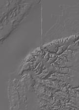
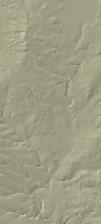
Surficial Geology of Dunlap Quadrangle
|
|
|
- Helena Barrett
- 6 years ago
- Views:
Transcription
1 Illinois Preliminary Geologic Map IPGM Dunlap-SG Surficial Geology of Dunlap Quadrangle Peoria County, Illinois François Hardy and C. Pius Weibel 2008 ILLINOIS STATE GEOLOGICAL SURVEY E. Donald McKay III, Interim Director Natural Resources Building 615 East Peabody Drive Champaign, IL
2


.")


 recognized three members")


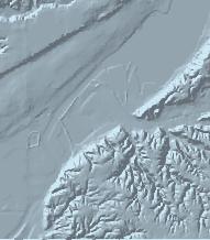
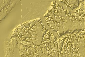
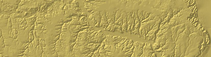
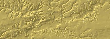
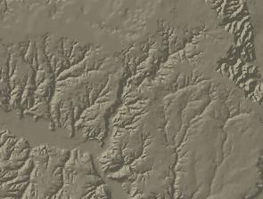
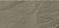

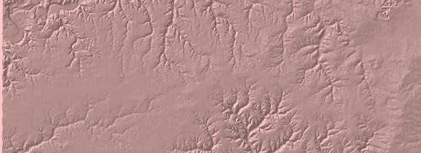
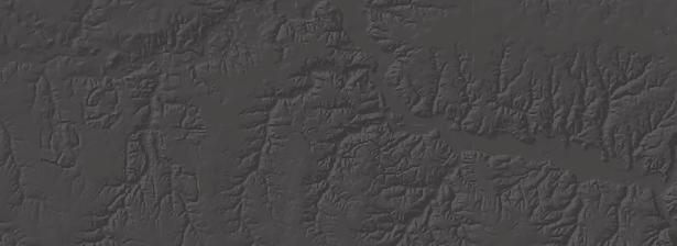
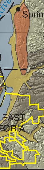
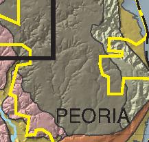
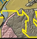
3 Dunlap Surficial Geology sediments are present within Peoria County (Udden 12, Wanless 5, Stumpf and Weibel 2005), but have not been found within the Dunlap Quadrangle. During the Illinois glacial episode, glaciers generally advanced westerly and retreated to the east across the area (Lineback 9). These glaciers eroded the existing landscape and deposited the diamicton of the widespread Glasford Formation in the Dunlap Quadrangle. In the adjacent Oak Hill Quadrangle, Willman and Frye (0) recognized three members of the Glasford in a roadcut exposure, now covered, in the Jubilee College Section (SW/4, SW/4, SW/4, Sec., TN, RE), about 1/4 mile west of the of the Dunlap Quadrangle. The members, in ascending order, are Hulick Till Member, Toulon Member, and Radnor Till Member. Willman and Frye considered the Toulon to represent outwash deposits associated with the Hulick Till and pro-glacial deposits associated with the Radnor Till, separated by an unnamed soil horizon. The Sangamon Geosol, which represents the interglacial (between the Illinois and s of glaciation) Sangamon Episode (Hansel and Johnson 96), also was exposed near the top of the Radnor Till at the Jubilee College Section. The Sangomon Geosol is not exposed in the Dunlap Quadrangle. The map depicts the geology of the surficial deposits of the Dunlap Quadrangle. On this map, surficial deposits consist of the unconsolidated and residual, alluvial, or glacial deposits which occur at or near the surface of the earth. The map also depicts where lithified strata (bedrock) crop out or are near the surface, but it does not depict the occurrence of loess, which blankets most of the quadrangle. The only previous detailed surficial maps which include this area are by Horberg (50), who differentiated Illinoian and Wisconsin drift, glacial outwash, alluvium, and bedrock on his 1:126,20 scale map of the Peoria County area, and Anderson and Hunter (65), who differentiated Illinoian glacial till and outwash deposits, Wisconsinan glacial till, outwash, and valley train deposits, sand dunes, slackwater deposits, and alluvium on their 1:63,360 scale map of Peoria County. The Dunlap Quadrangle is located about two and one-half to three miles west of the edge of the Illinois River Valley (fig. 1). The physiography of the quadrangle is dominated by broad uplands separated by narrow (Jubilee Creek and Hickory and Fargo Runs) to wider stream valleys (Kickapoo Creek) and their associated tributaries. The upland areas are dominated by glacial till overlain by loess (eolian sediments). Superimposed on this physiography is the terminal Buda Moraine and part of the Providence Moraine of the glaciation (fig. 1). During the ensuing glaciation, glaciers advanced from the east and covered over half of the quadrangle. As the glaciers stagnated and retreated, large amounts of meltwater transporting outwash and alluvium flowed down Kickapoo Creek and Fargo Run valleys, depositing these sediments along the streams and along the valley slopes. The combination of meltwater erosion and sediment deposition resulted in the noticeably wider Dunlap Lake Peoria and streams Chillicothe outwash plain till plain moraine r Spring Bay oo County boundary Creek Municipal boundary PEORIA Ill in Hanna City Illinois Episode till plain Germantown Hills ap ck Ki Elmwood Postglacial alluvial floodplain Ri ve Brimfield Provid en Buda Mo rain e Princeville ce Mora ine Quaternary sediments were deposited on the bedrock during the last two episodes of glaciation. Pre-Illinois Episode Bartonville s oi Washington EAST PEORIA Dunlap Quadrangle 0 5 MILES Figure 1 Shaded relief map of the Dunlap Quadrangle area with a superimposed, generalized Quaternary Geology map. Modified from Willman and Frye (0), Illinois State Geological Survey (2000), and Luman et al. (2003). The quadrangle is on the edge of glacial deposits, represented by the Buda Moraine. 1
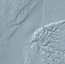
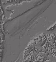
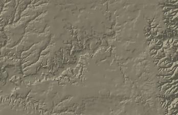
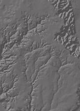
4 stream valley of the modern Kickapoo Creek and its associated tributaries. Subsequent erosion has removed some of the outwash deposits from the valley slopes. Lacustrine sediments were deposited during the retreat and stagnation of the glaciers and occur in three areas of the quadrangle. In the northeast quadrant, a temporary meltwater lake formed behind the Buda Moraine where lacustrine sediments accumulated until the Kickapoo outwash channel drained the lake. In the southeast quadrant, a second temporary meltwater lake formed in front of the Buda Moraine but behind a southward trending finger of the terminal moraine. A third occurrence of lacustrine deposits is situated near the western edge of the quadrangle along Kickapoo Creek. This deposit formed when valley train and outwash deposits damned the Illinois River valley just south of Peoria (Willman 3). During the damming of the creek extensive lacustrine deposits accumulated within the Kickapoo Creek watershed. Most lacustrine deposits occur up to an elevation of about 580 feet M.S.L., which indicates R. E. R. 8 E T. N. T. 9 N Loess Thickness Thick (>80 inches) Thin to medium ( 80 inches) MILES Very thin to absent (< inches) Figure 2 Generalized loess thickness map of the Dunlap Quadrangle. Where the Tiskilwa Formation is present, the loess consists only of the Peoria Silt; where the Tiskilwa is absent, the loess consists of the undifferentiated Peoria and Roxana Silts. According to McKay (9), the distinguishing characteristics of the two silts are subtle in many areas (McKay 9), including an exposure just to the west of the quadrangle, in Sec., TN, RE (Follmer et al. 9). In areas where loess is absent, the loess has been eroded or is incorporated into the soil. Areas of disturbed ground are not shown on this map. Modified after Walker (92). 2
5 that the lake level was at a higher elevation. Eventually the dam was breached and the lake was drained. Subsequent downcutting by erosion has removed significant portions of the lacustrine sediments. During both the Illinois and Wisconsin glacier episodes, westerly winds eroded silt from the floodplains of the Illinois and Mississippi River valleys, floodplains of other river valleys and from the numerous outwash channels and floodplains, including the outwash channel that is the modern Kickapoo Creek. These sediments, which are composed of the Roxana Silt and the overlying Peoria Silt, formed the blanket deposits of loess that occur throughout the region (fig. 2). The Roxana was deposited during the earlier Athens Subepisode of the, prior to deposition of the Tiskilwa Formation, whereas the Peoria was deposited during later Michigan Subepisode (Hansel and Johnson 96). In the adjacent (to the east) Spring Bay Quadrangle, Stumpf and Weibel (2005) had mapped the Peoria Silt as a separate unit where it succeeds the Tiskilwa Formation. An attempt was made to duplicate the mapping of that unit in the Dunlap Quadrangle, but the results were too inconsistent in be included on this map. From the time that the glaciers retreated from the area, stream and fluvial erosion has continued to remove the most recent glacial deposits, including the loess, and also to expose older Quaternary strata and bedrock. Methods The surficial geology map was constructed by interpretations of the parent materials from soils surveys (Soil Conservation Service 92, Illinois NRCS 2005), outcrop observations, interpretations of borehole data, and maps and field notes from previous researchers. Some boundaries were modified after study of aerial photo and topographic maps. Stratigraphic nomenclature follows Willman and Frye (0) as modified by Hansel and Johnson (96). Acknowledgments We thank the private landowners who graciously permitted us to drill on their properties and the Illinois Department of Transportation for providing drilling records. The views and conclusions contained in this document are those of the authors and should not be interpreted as necessarily representing the official policies, either expressed or implied, of the Illinois State Geological Survey, or the State of Illinois. References Anderson, R.C., and R.E. Hunter, 65, Sand and gravel resources of Peoria County: Illinois State Geological Survey, Circular 381, 16 p. 3 Follmer, L.R., E.D McKay, J.A. Lineback, and D.L. Gross, 9, Wisconsinan, Sangamonian, and Illinoian stratigraphy in central Illinois: Illinois State Geological Survey, Guidebook 13, 139 p. Hansel A.K., and W.H. Johnson, 96, Wedron and Mason Groups: Lithostratigraphic reclassification of deposits of the, Lake Michigan Lobe area: Illinois State Geological Survey, Bulletin 4, 116 p. Horberg, L., 50, Part 1 Geology, in L. Horberg, M. Suter, and T.E. Larson, Groundwater in the Peoria Region: Illinois State Geological Survey, Bulletin 5, p Illinois NRCS, 2005, Key to Illinois soils: Natural Resources Conservation Service, U.S. Department of Agriculture, 59 p. Illinois State Geological Survey, 2000, Surficial deposits of Illinois: Illinois State Geological Survey, Open File 2000-, 1:500,000. Lineback, J.A., 9, Status of the Illinoian glacial stage, in L.R. Follmer, E.D McKay, J.A. Lineback, and D.L. Gross, Wisconsinan, Sangamonian, and Illinoian stratigraphy in central Illinois: Illinois State Geological Survey, Guidebook 13, p Luman, D.E., L.R. Smith, and C.C. Goldsmith, 2003, Illinois surface topography: Illinois State Geological Survey, Illinois Map 11, 1:500,000. McKay, E. D., 9, Wisconsin loess stratigraphy of Illinois, in Follmer, L.R., E.D McKay, J.A. Lineback, and D.L. Gross, Wisconsinan, Sangamonian, and Illinoian stratigraphy in central Illinois: Illinois State Geological Survey, Guidebook 13, p Soil Conservation Service, 92, Soil survey of Peoria County, Illinois: U.S. Department of Agriculture, Illinois Agricultural Experiment Station Soil Report 132, 225 p. Stumpf, A.J., and C.P. Weibel, 2005, Surficial geology of Spring Bay Quadrangle, Peoria and Woodford Counties, Illinois: Illinois State Geological Survey, Illinois Geologic Quadrangle Map, IGQ Spring Bay-SG, 1:24,000. Udden, J.A., 12, Geology and mineral resources of the Peoria Quadrangle, Illinois: U.S. Geological Survey, Bulletin 506, 3 p. Walker, M.B., 92, Soil survey of Peoria County: USDA Natural Resources Conservation Service, Superintendent of Documents, Washington, D.C., 225 p. Wanless, H.R., 5, Geology and mineral resources of the Beardstown, Glasford, Havana, and Vermont Quadrangles: Illinois State Geological Survey, Bulletin 82, 233 p. Willman, H.B., 3, Geology along the Illinois Waterway A basis for environmental planning, Illinois State Geological Survey, Circular 48, 48 p. Willman, H.B., and Frye, J.C., 0, Pleistocene stratigraphy of Illinois: Illinois State Geological Survey, Bulletin 94, 204 p.
Surficial Geology of Oak Hill Quadrangle
 Illinois Preliminary Geologic Map IPGM Oak Hill-SG Surficial Geology of Oak Hill Quadrangle Peoria County, Illinois François Hardy and C. Pius Weibel 2008 ILLINOIS STATE GEOLOGICAL SURVEY E. Donald McKay
Surficial Geology of Antioch Quadrangle
 Illinois Preliminary Geologic Map IPGM Antioch-SG Surficial Geology of Antioch Quadrangle Lake County, Illinois and Kenosha County, Wisconsin Andrew J. Stumpf and Michael L. Barnhardt 2005 Department of
A surficial. P^HiHI waste disposal site, Bureau County, Illinois. east of the Sheffield low-level radioactive. electrical resistivity survey
 ISGS CONTRACT/GRANT REPORT 1981-6 WATER RESOURCES DIVISION/USGS P^HiHI 100240 557.09773 IL6cr 1981-6 A surficial electrical resistivity survey east of the Sheffield low-level radioactive waste disposal
Surficial Geology of Wauconda Quadrangle
 Illinois Preliminary Geologic Map IPGM Wauconda-SG 1:24,000 Surficial Geology of Wauconda Quadrangle Lake and McHenry Counties, Illinois Andrew J. Stumpf, Michael L. Barnhardt and Ardith K. Hansel Illinois
Surficial Geology of Mokena Quadrangle
 STATEMAP Mokena-SG Surficial Geology of Mokena Quadrangle Will and Cook Counties, Illinois Olivier J. Caron 16 Prairie Research Institute ILLINOIS STATE GEOLOGICAL SURVEY 615 East Peabody Drive Champaign,
Project Area. Funded by the Illinois Department of Transportation Springfield, Illinois
 Three-dimensional Geologic Mapping for Transportation Planning in Central-northern northern Illinois: Data Selection, Map Construction, and Model Development Richard C. Berg, E. Donald McKay, Donald A.
Surficial Geology of Henry County, Illinois
 Illinois County Geologic Map ICGM Henry-SG Surficial Geology of Henry County, Illinois Richard C. Anderson and Xiaodong Miao 2011 Prairie Research Institute ILLINOIS STATE GEOLOGICAL SURVEY 615 East Peabody
Geology and New England Landscapes
 Geology and New England Landscapes Jim Turenne, CPSS USDA-NRCS Warwick, RI. http://nesoil.com Why Geology? Provides the big picture of site conditions. Major part of soil formation (parent material and
The Geology of Sebago Lake State Park
 Maine Geologic Facts and Localities September, 2002 43 55 17.46 N, 70 34 13.07 W Text by Robert Johnston, Department of Agriculture, Conservation & Forestry 1 Map by Robert Johnston Introduction Sebago
SAND AND GRAVEL RESOURCES OF PEORIA COUNTY
 !' s 4. S: C.lR.38'/... C... STATE OF ILLINOIS DEPARTMENT OF REGISTRATION AND EDUCATION SAND AND GRAVEL RESOURCES OF PEORIA COUNTY Richard C. Anderson Ralph E. Hunter. ILLINOIS STATE GEOLOGICAL SURVEY
Surficial Geology of Wood River Quadrangle
 Illinois Preliminary Geologic Map IPGM Wood River-SG Surficial Geology of Wood River Quadrangle Madison County, Illinois David A. Grimley and Scott W. Lepley 2005 Department of Natural Resources ILLINOIS
Surficial Geologic Mapping Proposal for STATEMAP FY2019
 Surficial Geologic Mapping Proposal for STATEMAP FY2019 presented by David Grimley Illinois State Geological Survey Prairie Research Institute, University of Illinois IGMAC meeting, September 6 th, 2018
IGMAC 2015: Surficial Geologic Mapping STATEMAP past and future. Valparaiso Moraine, Will County
 IGMAC 2015: Surficial Geologic Mapping STATEMAP past and future Valparaiso Moraine, Will County presented by Drew Phillips, September 10. 2015 SURFICIAL MAPPING Completed Aug 2015 NE Illinois Project:
fregonruleco. 1 U.S.A. 2
 3 5 fregonruleco. 1 U.S.A. 2 557.09773 IL6cr 1985-1 Qojl ^^\ ISGS CONTRACT/GRANT REPORT 1985-1 GEOPHYSICAL STUDIES AT THE SHEFFIELD LOW-LEVEL RADIOACTIVE WASTE DISPOSAL FACILITY TO EVALUATE POTENTIAL PATHWAYS
Maggie Payne Jim Turenne
 Maggie Payne Jim Turenne USDA-NRCS 60 Quaker Lane, Suite 46 Warwick, RI. 02886 401-822-8832 maggie.payne@ri.usda.gov U.S. Department of Agriculture 1935: Soil Conservation Service (SCS) Natural Resources
Jim Turenne. Soils on Social Media
 Jim Turenne USDA-NRCS 60 Quaker Lane, Suite 46 Warwick, RI. 02886 401-822-8832 Jim.turenne@ri.usda.gov Soils on Social Media www.twitter.com/soilsne www.fb.com/soilsne www.nesoil.com U.S. Department of
Which landscape best represents the shape of the valleys occupied by glaciers? A) B) C) D)
 B) C) D)") 1. Glaciers often form parallel scratches and grooves in bedrock because glaciers A) deposit sediment in unsorted piles B) deposit rounded sand in V-shaped valleys C) continually melt and refreeze D) drag
1. Glaciers often form parallel scratches and grooves in bedrock because glaciers A) deposit sediment in unsorted piles B) deposit rounded sand in V-shaped valleys C) continually melt and refreeze D) drag
Soil Formation. Parent Material. Time. Climate
 Soil Formation Parent Material Time Climate Topography Biota Main Objectives 1. Gain a general understanding of soil formation processes 2. Understand the importance of mineral weathering in soil formation
THE OHIO JOURNAL OF SCIENCE
 THE OHIO JOURNAL OF SCIENCE VOL. LIII MARCH, 1953 No. 2 SUBSURFACE STUDY OF GLACIAL DEPOSITS AT CLEVELAND, OHIO C. T. BAGLEY Sverdrup & Parcel, Inc., Consulting Engineers, St. Lotus, Mo. The soil 1 strata
Page 1. Name:
 Name: 1) Which property would best distinguish sediment deposited by a river from sediment deposited by a glacier? thickness of sediment layers age of fossils found in the sediment mineral composition
THE BEDROCK SURFACE AND FORMER DRAINAGE SYSTEMS OF MONTGOMERY COUNTY, OHIO 1
 THE BEDROCK SURFACE AND FORMER DRAINAGE SYSTEMS OF MONTGOMERY COUNTY, OHIO 1 STANLEY E. NORRIS, Geologist, U. S. Geological Survey, Columbus, Ohio INTRODUCTION The bedrock surface of Montgomery County,
Pat Dryer Half Moon Lake: A True Oxbow Lake? Geography 364 April 1 st, 2007
 Pat Dryer Half Moon Lake: A True Oxbow Lake? Geography 364 April 1 st, 2007 Appendix Abstract 2 Introduction 3 Methods 3 Results 3 Discussion 5 Conclusion 11 1 Abstract Half Moon Lake appears to be an
A method for three-dimensional mapping, merging geologic interpretation, and GIS computation
 A method for three-dimensional mapping, merging geologic interpretation, and GIS computation Soller, David R., U.S. Geological Survey, 908 National Center, Reston, VA 20192 and Richard C. Berg, Illinois
NEAR THE VILLAGE OF NORTH AURORA, ILLINOIS RESULTS OF A SHALLOW SEISMIC REFRACTION SURVEY. Timothy H. Larson. QsuJk Sa^^oJ^M. Philip G.
 557 IL6of 1991-15 QsuJk Sa^^oJ^M RESULTS OF A SHALLOW SEISMIC REFRACTION SURVEY NEAR THE VILLAGE OF NORTH AURORA, ILLINOIS Timothy H. Larson Philip G. Orozco Open File Series 1991-15 ILLINOIS STATE GEOLOGICAL
Vermont Stream Geomorphic Assessment. Appendix E. River Corridor Delineation Process. VT Agency of Natural Resources. April, E0 - April, 2004
 Vermont Stream Geomorphic Assessment Appendix E River Corridor Delineation Process Vermont Agency of Natural Resources - E0 - River Corridor Delineation Process Purpose A stream and river corridor delineation
Lecture Outline Lecture Outline Monday April 9-16, 2018 Questions? Announcements:
 Lecture Outline Lecture Outline Monday April 9-16, 2018 Questions? Announcements: Geology 101 Night Video: The Day After Tomorrow Hollywood disaster movie about the onset of a glacial period When: Monday
Evidence for distribution and thickness of Athens Sub-episode and older sediments in Ottawa County, Michigan
 Evidence for distribution and thickness of Athens Sub-episode and older sediments in Ottawa County, Michigan Patrick M. Colgan Department of Geology Grand Valley State University With thanks to Al Kehew
 Page 1 of 9 Name: Base your answer to the question on the diagram below. The arrows show the direction in which sediment is being transported along the shoreline. A barrier beach has formed, creating a
Landscape. Review Note Cards
 Landscape Review Note Cards Last Ice Age Pleistocene Epoch that occurred about 22,000 Years ago Glacier A large, long lasting mass of ice which forms on land and moves downhill because of gravity. Continental
Prentice Hall EARTH SCIENCE
 Prentice Hall EARTH SCIENCE Tarbuck Lutgens Chapter 7 Glaciers, Desert, and Wind 7.1 Glaciers Types of Glaciers A glacier is a thick ice mass that forms above the snowline over hundreds or thousands of
iii CONTENTS vii ACKNOWLEDGMENTS EXECUTIVE SUMMARY INTRODUCTION Study Area Data Sources Preparation of Geologic Maps
 CONTENTS ACKNOWLEDGMENTS EXECUTIVE SUMMARY INTRODUCTION Study Area Data Sources Preparation of Geologic Maps GEOLOGY Bedrock Geology Succession and Distribution Structural Features Description of Bedrock
Big Rivers Electric Corporation Disposal of Coal Combustion Residuals (CCR) from Electric Utilities Final Rule CCR Impoundment Liner Assessment Report
 from Electric Utilities Final Rule CCR Impoundment Liner Assessment Report") Big Rivers Electric Corporation Disposal of Coal Combustion Residuals (CCR) from Electric Utilities Final Rule CCR Impoundment Liner Assessment Report CCR Surface Impoundment Information Name: Operator:
Big Rivers Electric Corporation Disposal of Coal Combustion Residuals (CCR) from Electric Utilities Final Rule CCR Impoundment Liner Assessment Report CCR Surface Impoundment Information Name: Operator:
,Baynes Lake. TO...?&.?...A 2...KO.?'!!&... Sr. *logical Engineer
 > i evernment OF BRITISH COLUMBIA a TO...?&.?...A 2....KO.?'!!&... Sr. *logical Engineer... Grou,,water. Section Hydrology Division Wat.er... In~.~s.tiga.ti.On.s..Branck.... 5 u BJECT...C;.roun.dw.ater...Snve
Waterbury Dam Disturbance Mike Fitzgerald Devin Rowland
 Waterbury Dam Disturbance Mike Fitzgerald Devin Rowland Abstract The Waterbury Dam was completed in October 1938 as a method of flood control in the Winooski Valley. The construction began in April1935
What are the different ways rocks can be weathered?
 Romano - 223 What are the different ways rocks can be weathered? Weathering - the breakdown of rocks and minerals at the Earth s surface 1. 2. PHYSICAL WEATHERING Rock is broken into smaller pieces with
Surficial Geology of Keyesport Quadrangle
 Illinois Geologic Quadrangle Map IGQ Keyesport-SG Surficial Geology of Keyesport Quadrangle Clinton, Bond, and Fayette Counties, Illinois David A. Grimley and Katarzyna A. Walkowska 2017 615 East Peabody
Buried-valley Aquifers: Delineation and Characterization from Reflection Seismic and Core Data at Caledon East, Ontario
 Buried-valley Aquifers: Delineation and Characterization from Reflection Seismic and Core Data at Caledon East, Ontario Russell, H.A.J. 1, S.E. Pullan 1, J.A. Hunter 1, D.R. Sharpe 1, and S. Holysh 2 1
mmm "i .JIM » BH tifltftfttt! II Hal JhHb in' Unli lltt' Mwfi WUH1 ulflif ith Itt M H!;.! > ;.'!,/;' 11 I mfgbrhmyfhnm H <: - *
 mmm "i.jim 1 >'» BH H tifltftfttt! II Hal JhHb in' Unli It lltt' Mwfi WUH1 ulflif ith il Itt 111 M H!;.! > ;.'!,/;' mfgbrhmyfhnm 11 I t H \ Library of ^U^OlS GEOLOGICAL SURVEY URBANA A STATE
Soils of Rhode Island
 Soils of Rhode Island Jim Turenne, RI State Soil Scientist USDA-NRCS 60 Quaker Ln. Suite 46 Warwick, RI. 02886 401-822-8830 http://nesoil.com Jim.turenne@ri.usda.gov About NRCS Established as the Soil
SURFACE GEOLOGY AND LIQUEFACTION SUSCEPTIBILITY IN THE INNER RIO GRANDE VALLEY NEAR ALBUQUERQUE, NEW MEXICO
 SURFACE GEOLOGY AND LIQUEFACTION SUSCEPTIBILITY IN THE INNER RIO GRANDE VALLEY NEAR ALBUQUERQUE, NEW MEXICO Keith I. Kelson, Christopher S. Hitchcock, and Carolyn E. Randolph William Lettis & Associates,
Basin Analysis Applied to Modelling Buried Valleys in the Great Lakes Basin
 EARTH SCIENCES SECTOR GENERAL INFORMATION PRODUCT 35 Basin Analysis Applied to Modelling Buried Valleys in the Great Lakes Basin Sharpe, D R; Russell, H A J 2004 Originally released as: Basin Analysis
Michigan s Geology and Groundwater
 Michigan s Geology and Groundwater Ralph J. Haefner Deputy Director U.S. Geological Survey Michigan-Ohio Water Science Center Lansing, Michigan Outline About the USGS Geology 101 Michigan s geology Bedrock
Laboratory Exercise #4 Geologic Surface Processes in Dry Lands
 Page - 1 Laboratory Exercise #4 Geologic Surface Processes in Dry Lands Section A Overview of Lands with Dry Climates The definition of a dry climate is tied to an understanding of the hydrologic cycle
Name: Which rock layers appear to be most resistant to weathering? A) A, C, and E B) B and D
 A, C, and E B) B and D") Name: 1) The formation of soil is primarily the result of A) stream deposition and runoff B) precipitation and wind erosion C) stream erosion and mass movement D) weathering and biological activity 2)
Name: 1) The formation of soil is primarily the result of A) stream deposition and runoff B) precipitation and wind erosion C) stream erosion and mass movement D) weathering and biological activity 2)
Geological Mapping using Geophysics
 Geological Mapping using Geophysics Pugin, A.J.M. and T.H. Larson Illinois State Geological Survey, 615 E Peabody Dr., Champaign, IL 61820; E-mail: A.J.M. Pugin at pugin@isgs.uiuc.edu Mapping Techniques.
June 9, R. D. Cook, P.Eng. Soils Engineer Special Services Western Region PUBLIC WORKS CANADA WESTERN REGION REPORT ON
 PUBLIC WORKS CANADA WESTERN REGION REPORT ON GEOTECHNICAL INVESTIGATION PROPOSED MARTIN RIVER BRIDGE MILE 306.7 MACKENZIE HIGHWAY Submitted by : R. D. Cook, P.Eng. Soils Engineer Special Services Western
4. The map below shows a meandering stream. Points A, B, C, and D represent locations along the stream bottom.
 1. Sediment is deposited as a river enters a lake because the A) velocity of the river decreases B) force of gravity decreases C) volume of water increases D) slope of the river increases 2. Which diagram
Pratice Surface Processes Test
 1. The cross section below shows the movement of wind-driven sand particles that strike a partly exposed basalt cobble located at the surface of a windy desert. Which cross section best represents the
RIVERS, GROUNDWATER, AND GLACIERS
 RIVERS, GROUNDWATER, AND GLACIERS Delta A fan-shaped deposit that forms when a river flows into a quiet or large body of water, such as a lake, an ocean, or an inland sea. Alluvial Fan A sloping triangle
Geologic Mapping in Northeastern Illinois. What do we know about. Donald A. Keefer, Director Geologic Mapping and Hydrogeology Center
 Geologic Mapping in Northeastern Illinois & What do we know about Lake County s Geology? Donald A. Keefer, Director Geologic Mapping and Hydrogeology Center Societal Benefits of Mapping Water Supply Delineation,
3. GEOLOGY. 3.1 Introduction. 3.2 Results and Discussion Regional Geology Surficial Geology Mine Study Area
 3. GEOLOGY 3.1 Introduction This chapter discusses the baseline study of the geology and mineralization characteristics of the mine study area. The study consolidates existing geological data and exploration
Illinois State Water Survey Division
 Illinois State Water Survey Division SURFACE WATER SECTION SWS Contract Report 413 AT THE UNIVERSITY OF ILLINOIS SEDIMENTATION SURVEY OF DAWSON LAKE, MORAINE VIEW STATE PARK, MC LEAN COUNTY, ILLINOIS by
Surficial Geology of Mascoutah Quadrangle
 llinois Geologic Quadrangle Map GQ Mascoutah-SG Revision Surficial Geology of Mascoutah Quadrangle St. Clair County, llinois David A. Grimley 2010 nstitute of Natural Resource Sustainability William W.
1. The map below shows a meandering river. A A' is the location of a cross section. The arrows show the direction of the river flow.
 1. The map below shows a meandering river. A A' is the location of a cross section. The arrows show the direction of the river flow. Which cross section best represents the shape of the river bottom at
GEOL.3250 Geology for Engineers Glacial Geology
 GEOL.3250 Geology for Engineers Glacial Geology NAME Part I: Continental Glaciation Continental glaciers are large ice sheets that cover substantial portions of the land area. In the region of accumulation
KRIS wsbssm. IBHiiilll
 KRIS wsbssm IBHiiilll Digitized by the Internet Archive in 2012 with funding from University of Illinois Urbana-Champaign http://archive.org/details/engineeringaspec34ekbl STATE OF ILLINOIS HENRY HORNER,
CK-UNIT MAPPING OF GEOLOGIC MATERIALS IN ILLINOIS TO A DEPTH OF 15 METERS
 s 14.GS: CIR 542 c.4 - CK-UNIT MAPPING OF GEOLOGIC MATERIALS IN ILLINOIS TO A DEPTH OF 15 METERS llun.ots GEOLOGICAL survey LIBRARY r Richard C. Berg and John P. Kempton ILLINOIS STATE GEOLOGICAL SURVEY
Class Notes: Surface Processes
 Name: Date: Period: Surface Processes The Physical Setting: Earth Science Class Notes: Surface Processes I. Weathering and Soils Weathering -! Sediments -! Weathering occurs when rocks are exposed to:
Great Lakes Tributary Modeling: Canaseraga Creek Watershed
 Great Lakes Tributary Modeling: Canaseraga Creek Watershed SWAT Model Authority: Section 516(e) of WRDA 1996 US Army Corps of Engineers Canaseraga Creek Project Location - Encompasses portions of Livingston,
Name: Mid-Year Review #2 SAR
 Name: Mid-Year Review #2 SAR Base your answers to questions 1 through 3 on on the diagram below, which shows laboratory materials used for an investigation of the effects of sediment size on permeability,
Unit 3 Review - Surface Processes
 Unit 3 Review - Surface Processes 1. Why is the surface of Mercury covered with meteor impact craters, while Earth s surface has relatively few craters? A) Mercury is larger than Earth, so it gets hit
Guided Notes Surface Processes. Erosion & Deposition By: Glaciers
 Guided Notes Surface Processes Erosion & Deposition By: Glaciers K. Coder 2015 26) How does moving ice erode and deposit sediments? Glaciers (Movement of Ice): a naturally formed mass of ice and snow that
The Montauk Peninsula: Data and Preliminary Interpretations of the Ditch Plains Area Introduction
 The Montauk Peninsula: Data and Preliminary Interpretations of the Ditch Plains Area John A. Black GSI Patchogue, New York R.S. Welch Suffolk Community College Selden, New York Introduction Sirkin, (1982)
Bell Ringer. Are soil and dirt the same material? In your explanation be sure to talk about plants.
 Bell Ringer Are soil and dirt the same material? In your explanation be sure to talk about plants. 5.3 Mass Movements Triggers of Mass Movements The transfer of rock and soil downslope due to gravity is
I DES TERRAINS DIVISION. D. F. VanDine TERRAIN SCIENCES RESOURCE INVENTORY - MACKFWIE. Scale 1 : 250,000. D. E. Lawrence LA DIV'3'QN DE LA SCIENCE
 GRAN- RESOURCE INVENTORY - MACKFWIE LAC BELOT NTS 96 L SW4 Scale 1 : 250,000 D. E. Lawrence D. F. VanDine For: Department of Indian and Northern Affairs TERRAIN SCIENCES DIVISION LA DIV'3'QN DE LA SCIENCE
The boulder was most likely moved to this location by A) glacial ice B) prevailing wind C) streamfiow D) volcanic action
 glacial ice B) prevailing wind C) streamfiow D) volcanic action") 1. Which rock material was most likely transported to its present location by a glacier? A) rounded sand grains found in a river delta B) rounded grains found in a sand dune C) residual soil found on a
1. Which rock material was most likely transported to its present location by a glacier? A) rounded sand grains found in a river delta B) rounded grains found in a sand dune C) residual soil found on a
W he natural resources of Adams
 Above: Houghton Rock, Town of Adams. Following Page: "The Hole in the Rock" on Rattlesnake Mound--both remnants of rock formed by ancient seas hundreds of millions of year5 ago. (Courtesy, H.H. Bennett
Chapter 2. Wearing Down Landforms: Rivers and Ice. Physical Weathering
 Chapter 2 Wearing Down Landforms: Rivers and Ice Physical Weathering Weathering vs. Erosion Weathering is the breakdown of rock and minerals. Erosion is a two fold process that starts with 1) breakdown
Groundwater Geology of DeKalb County, Illinois with Emphasis on the Troy Bedrock Valley
 C 563 Groundwater Geology of DeKalb County, Illinois with Emphasis on the Troy Bedrock Valley Robert C. Vaiden, Edward C. Smith, and Timothy H. Larson Circular 563 4 Illinois Department of Natural Resources
Glacial Geology of Moose Point State Park, ME
 Geologic Site of the Month May, 2013 Glacial Geology of Moose Point State Park, Maine 44 o 25 59.18"N, 68 o 56 37.11"W Text and photos by Woodrow B. Thompson, Department of Agriculture, Conservation &
GLACIAL DRIFT IN ILLINOIS: THICKNESS AND CHARACTER
 ,. rt& s it.{.. Et5: CIR. i.fl(.,, C- STATE OF ILLINOIS f' DEPARTMENT OF REGISTRATION AND EDUCATION GLACIAL DRIFT IN ILLINOIS: THICKNESS AND CHARACTER Kemal Piskin Robert E. Bergstrom (.,_ - J,: SlJ1:
Correlation of Tills Exposed in Toledo Edison Dam Cut, Ohio
 The Ohio State University Knowledge Bank kb.osu.edu Ohio Journal of Science (Ohio Academy of Science) Ohio Journal of Science: Volume 60, Issue 2 (March, 1960) 1960-03 Correlation of Tills Exposed in Toledo
Chapter 5: Glaciers and Deserts
 I. Glaciers and Glaciation Chapter 5: Glaciers and Deserts A. A thick mass of ice that forms over land from the compaction and recrystallization of snow and shows evidence of past or present flow B. Types
THE KANSAN GLACIATION IN SOUTHEASTERN INDIANA 1
 THE KANSAN GLACIATION IN SOUTHEASTERN INDIANA 1 ANSEL M. GOODING Earlham College, Richmond, Indiana ABSTRACT Buried Kansan drift and Yarmouth soil beneath Illinoian drift are described from three locations
Glacial Modification of Terrain
 Glacial Modification Part I Stupendous glaciers and crystal snowflakes -- every form of animate or inanimate existence leaves its impress upon the soul of man. 1 -Orison Swett Marden Glacial Modification
Glacial Deposition and Groundwater in Dutchess County
 Glacial Deposition and Groundwater in Dutchess County Name: Period: Thousands of years ago an enormous ice sheet blanketed the Hudson Valley in what was called the Wisconsinan Glaciation. The ice reshaped
April
 April 2016 5 993-1410-007.006 2.0 PHYSICAL SETTING AND HYDROGEOLOGY This section provides background information on the physical setting and hydrogeology of the Tumwater area based on previous investigations
Seismic Reflection Imaging across the Johnson Ranch, Valley County, Idaho
 Seismic Reflection Imaging across the Johnson Ranch, Valley County, Idaho Report Prepared for the Skyline Corporation Lee M. Liberty Center for Geophysical Investigation of the Shallow Subsurface (CGISS)
General Geologic Setting and Seismicity of the FHWA Project Site in the New Madrid Seismic Zone
 General Geologic Setting and Seismicity of the FHWA Project Site in the New Madrid Seismic Zone David Hoffman University of Missouri Rolla Natural Hazards Mitigation Institute Civil, Architectural & Environmental
August 21, 2015 Project No. EH130228A. Concrete Nor West P.O. Box 280 Mount Vernon, Washington Attention: Mr. Dan Cox
 August 21, 2015 Project No. EH130228A Concrete Nor West P.O. Box 280 Mount Vernon, Washington 98273 Attention: Mr. Dan Cox Subject: Hydrogeologic Site Assessment Concrete Nor West Grip Road Mine Skagit
Midterm Review. Nata/Lee
 Name: 1. Which statement best supports the theory that all the continents were once a single landmass? (1) Rocks of the ocean ridges are older than those of the adjacent sea floor. (2) Rock and fossil
Lecture Outlines PowerPoint. Chapter 6 Earth Science 11e Tarbuck/Lutgens
 Lecture Outlines PowerPoint Chapter 6 Earth Science 11e Tarbuck/Lutgens 2006 Pearson Prentice Hall This work is protected by United States copyright laws and is provided solely for the use of instructors
Green River Lowland and
 EG 149 14.GS: EGN 149 c. 3 (X^JL^uu^-j Hydrogeology of the Green River Lowland and Associated Bedrock Valleys in Northwestern Illinois David R. Larson Beverly L. Herzog Robert C. Vaiden Cheri A. Chenoweth
Lower Mainland Surficial Geology From Wisconsin Ice Age to Protocol 21
 Lower Mainland Surficial Geology From Wisconsin Ice Age to Protocol 21 BCEIA BEST Conference 2018 Whistler, BC Kalina Malowany and Virginie Brunetaud Presentation Outline 1. Surficial Geology it s more
NDWRCDP Disclaimer This work was supported by the National Decentralized Water Resources Capacity Development Project (NDWRCDP) with funding provided
 with funding provided") Glacial Landforms NDWRCDP Disclaimer This work was supported by the National Decentralized Water Resources Capacity Development Project (NDWRCDP) with funding provided by the U.S. Environmental Protection
Glacial Landforms NDWRCDP Disclaimer This work was supported by the National Decentralized Water Resources Capacity Development Project (NDWRCDP) with funding provided by the U.S. Environmental Protection
NEW PRODUCTS AND ADVANCEMENTS IN 3-D MODELLING PROTOCOLS BASED ON STUDIES IN THICK DRIFT AREAS IN ONTARIO, CANADA
 NEW PRODUCTS AND ADVANCEMENTS IN 3-D MODELLING PROTOCOLS BASED ON STUDIES IN THICK DRIFT AREAS IN ONTARIO, CANADA Abigail K. Burt and Andrew F. Bajc Ontario Geological Survey, 933 Ramsey Lake Road, Sudbury,
STREAM SYSTEMS and FLOODS
 STREAM SYSTEMS and FLOODS The Hydrologic Cycle Precipitation Evaporation Infiltration Runoff Transpiration Earth s Water and the Hydrologic Cycle The Hydrologic Cycle The Hydrologic Cycle Oceans not filling
Precipitation Evaporation Infiltration Earth s Water and the Hydrologic Cycle. Runoff Transpiration
 STREAM SYSTEMS and FLOODS The Hydrologic Cycle Precipitation Evaporation Infiltration Earth s Water and the Hydrologic Cycle Runoff Transpiration The Hydrologic Cycle The Hydrologic Cycle Oceans not filling
TOWARD A GOAL OF A SUPER THREE-DIMENSIONAL GEOLOGICAL MAP
 TOWARD A GOAL OF A SUPER THREE-DIMENSIONAL GEOLOGICAL MAP Richard C. Berg 1 and David R. Soller 2 1 Illinois State Geological Survey, Champaign, IL, USA, berg@isgs.uiuc.edu 2 U.S. Geological Survey, Reston,
Name: Class: Date: Multiple Choice Identify the letter of the choice that best completes the statement or answers the question.
 Name: Class: Date: geology ch 7 test 2008 Multiple Choice Identify the letter of the choice that best completes the statement or answers the question. 1. Which of the following is true about ice sheets?
1. Any process that causes rock to crack or break into pieces is called physical weathering. Initial product = final product
 Weathering 1. Any process that causes rock to crack or break into pieces is called physical weathering. Initial product = final product End Result of physical weathering is increased surface area. 2. Physical
What is a Glacier? Types of Glaciers
 Alpine & Continental Glaciers Glacial Mass Balance Glacial Ice Formation Glacial Movement & Erosion Erosional and Depositional Landforms The Pleistocene Epoch Geomorphology of SW Manitoba Chapter 17 1
Why is Sebago Lake so deep?
 Maine Geologic Facts and Localities February, 1999 Why is Sebago Lake so deep? 43 51 13.36 N, 70 33 43.98 W Text by Robert A. Johnston, Department of Agriculture, Conservation & Forestry 1 Introduction
APPENDIX G GLOSSARY. Mn/DOT/WR-0200
 APPENDIX G GLOSSARY Mn/DOT/WR-0200 Alluvial - comprised of clay, silt, sand, gravel, and/or other detritus deposited by water. Usually refers to accretionary overbank, floodplain or levee deposits. Biomantling
Evidence of Ice Retreat, East Shore of Sabattus Pond
 Maine Geologic Facts and Localities November, 2002 Evidence of Ice Retreat, East Shore of Sabattus Pond 44 7 25.14 N, 70 5 21.69 W Text by Michael E. Foley, Department of Agriculture, Conservation & Forestry
How Do Human Impacts and Geomorphological Responses Vary with Spatial Scale in the Streams and Rivers of the Illinois Basin?
 How Do Human Impacts and Geomorphological Responses Vary with Spatial Scale in the Streams and Rivers of the Illinois Basin? Bruce Rhoads Department of Geography University of Illinois at Urbana-Champaign
GEOLOGICAL SURVEY OF CANADA PAPER REPORT OF ACTIVITIES, Part A: April to October, 1968 DEPARTMENT OF ENERGY, MINES AND RESOURCES.
 GEOLOGICAL SURVEY OF CANADA PAPER 69-1 Part A REPORT OF ACTIVITIES, Part A: April to October, 1968 DEPARTMENT OF ENERGY, MINES AND RESOURCES @ Crown Copyrights reserved Availahlc by rn:~il from thc Quecn's
Betsy Stevenson and Allison Mohrs (Skagit County Planning and Development Services) Jenny Baker, The Nature Conservancy
 Jenny Baker, The Nature Conservancy") TC Fisher Slough Final Design and Permitting Subject: Well Review Memorandum To: From: Betsy Stevenson and Allison Mohrs (Skagit County Planning and Development Services) Jenny Baker, The ature Conservancy
TC Fisher Slough Final Design and Permitting Subject: Well Review Memorandum To: From: Betsy Stevenson and Allison Mohrs (Skagit County Planning and Development Services) Jenny Baker, The ature Conservancy
Glaciers. (Shaping Earth s Surface, Part 6) Science 330 Summer 2005
 Science 330 Summer 2005") Glaciers (Shaping Earth s Surface, Part 6) Science 330 Summer 2005 1 Glaciers Glaciers are parts of two basic cycles Hydrologic cycle Rock cycle Glacier a thick mass of ice that originates on land from
Glaciers (Shaping Earth s Surface, Part 6) Science 330 Summer 2005 1 Glaciers Glaciers are parts of two basic cycles Hydrologic cycle Rock cycle Glacier a thick mass of ice that originates on land from
GLACIAL GEOLOGY OF THE
 i42 S 14.GS: CIR442 c. 1 ILLINOtS GEOLOGICAL SURVEY LIBRARY STATE OF ILLINOIS DEPARTMENT OF REGISTRATION AND EDUCATION GLACIAL GEOLOGY OF THE VANDALIA. ILLINOIS. REGION Alan M. Jacobs Jerry A. Lineback