The Geology and Hydrogeology of the Spyhill Area
|
|
|
- Denis Johns
- 5 years ago
- Views:
Transcription


1 The Geology and Hydrogeology of the Spyhill Area Clare North (WorleyParsons Komex) and Martin Ortiz (The City of Calgary) 2-Jul-08
2 Outline Background Site Location Existing Information New Work Geology Hydrogeology Summary 2

3 Site Location 3

4 Regional Topography 4
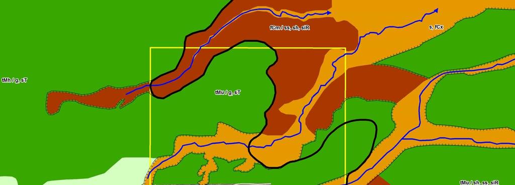
5 Existing Information Published Information Moran (1986) identified 3 geologic units in the area: Till (Quaternary Lochend and Upper Spyhill Formations) Gravel (Tertiary Undivided layer) Bedrock (Tertiary Porcupine Hills Formation) Distribution was approximate based on limited borehole data Landfill Reports Gravel mining feasibility reports Annual approval reports Anecdotal Information Several gravel pits in the area 5

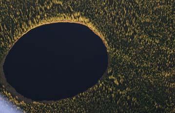
6 Aerial Photograph Interpretation Incised coulee system Developed Area 6
7 Surficial Geology Mapping Colluvial > 5m Colluvial < 5m Till > 5 m Till < 5 m Glaciofluvial 7
8 Intrusive Investigation Drilling Ground truth aerial photograph interpretation Challenging drilling due to highly variable geology Coring of three boreholes 8

9 Geology Glacial Deposits Colluvial > 5m Colluvial < 5m Till > 5 m Till < 5 m Glaciofluvial 9

10 Geology Colluvial Deposits Colluvial > 5m Colluvial < 5m Till > 5 m Till < 5 m Glaciofluvial 10

11 Geology Gravels Colluvial > 5m Colluvial < 5m Till > 5 m Till < 5 m Glaciofluvial 11
12 Geology - Gravels Gravel Deposits - several cemented horizons identified Cemented horizons tend to be thin (<0.5 m) and discontinuous One thicker (~2 m) and apparently continuous cemented horizon located masl Origin of cementation is unknown 12

13 Geology Bedrock Topography Bedrock Valley Higher Elevations masl 13
14 Geology - Bedrock Interbedded mudstones, siltstones and sandstones Sandstone units rare and typically thin (< 2 m) Top Highly weathered Bottom 14
15 Fracture Distribution >15-20 m 11.0% >20-25 m 5.1% >25-30 m 0.4% Proportional Distribution of Fractures with Depth below Bedrock Surface >10-15 m 20.2% m 37.9% >5-10 m 25.3% Sandstone 7% Proportional Distribution of Fractures by Lithology Siltstone 30% Mudstone 63% 15
16 Hydrogeology - Overview Groundwater bearing zones 3 main groundwater bearing zones identified based on: Elevation of installation Groundwater levels Hydrochemistry Perched groundwater in some areas Occurrence 16

17 Hydrogeology 1 st GWBZ Potential for groundwater/surface water interaction Highly variable aquifer properties Groundwater flow generally toward the northeast Calcium bicarbonate hydrochemical water type 17
18 Hydrogeology - 2 nd GWBZ Exclusively in bedrock Calcium magnesium bicarbonate and sodium bicarbonate hydrochemical water types Generally some degree of hydraulic connection with 1 st GWBZ based on vertical gradients ~ 0 to 0.5 Groundwater flow toward the northeast Aquifer test was undertaken to evaluate hydrogeologic properties 18
19 2 nd GWBZ Aquifer Test Largest Response Minimal Response Next Largest Response 19
20 2 nd GWBZ Aquifer Test Dual Porosity System? 20
21 Hydrogeology 3 rd GWBZ Found deeper in bedrock (~50 mbgs) Groundwater flow toward east or northeast Sodium bicarbonate hydrochemical water type Single well hydraulic conductivities < 2 nd GWBZ Generally hydraulically isolated from 2 nd GWBZ based on vertical gradients > 1 at nested locations 21
22 Hydrogeology Perched Water Identified based on anomalous groundwater levels and vertical gradients >1 at nested locations Perched water identified above cemented layer in gravel at some locations 22
23 Summary Large area with variable topography and geology Aerial photograph interpretation was a useful tool Distribution of surficial deposits partially dictated by topography Drilling confirmed much of the aerial photograph interpretation Drilling was challenging 23
24 Summary 3 main GWBZs identified Complex 1 st GWBZ 2 nd GWBZ flow influenced by fractures Flow generally toward northeast in all 3 zones Perched water above cemented layer Development of a reliable conceptual model required compilation of data from several parts of the investigation 24
Finding Large Capacity Groundwater Supplies for Irrigation
 Finding Large Capacity Groundwater Supplies for Irrigation December 14, 2012 Presented by: Michael L. Chapman, Jr., PG Irrigation Well Site Evaluation Background Investigation Identify Hydrogeologic Conditions
Differentiation of chloride source using stable chlorine isotopes
 Differentiation of chloride source using stable chlorine isotopes RemTech 2009 Banff, Alberta October 14-16 2009 Dr. Alec Blyth and Tom Anthony 1 1 currently City of Calgary Background: DOW Chemical Canada
WaterTech 2017 April 4, 2017
 Haskayne Master Drainage Plan: Hydraulic Relationships Between Groundwater Flow Systems and the Bearspaw Reservoir and Potential for Stormwater Disposal, City of Calgary WaterTech 2017 April 4, 2017 Project
Buried Bedrock Channels in the Athabasca Oil Sands Region Conceptual Understanding and Implications to Water Supply
 Buried Bedrock Channels in the Athabasca Oil Sands Region Conceptual Understanding and Implications to Water Supply Scott Rayner Matrix Solutions Inc. Sandra Rosenthal Devon Canada Corporation Presentation
Groundwater Monitoring & Aggregate Operations in the Villeneuve-Calahoo Area. William Gowdy, BSc. P.Geo
 Groundwater Monitoring & Aggregate Operations in the Villeneuve-Calahoo Area William Gowdy, BSc. P.Geo Format of Talk General Background Sand and Gravel Geology & Formation of Sand and Gravel Deposits
Connecticut's Aquifers
 Page 1 of 5 DEP Search: Connecticut's Aquifers The technical definition of the word "aquifer" is: any geologic formation capable of yielding significant quantities of water to wells. By that definition,
iii CONTENTS vii ACKNOWLEDGMENTS EXECUTIVE SUMMARY INTRODUCTION Study Area Data Sources Preparation of Geologic Maps
 CONTENTS ACKNOWLEDGMENTS EXECUTIVE SUMMARY INTRODUCTION Study Area Data Sources Preparation of Geologic Maps GEOLOGY Bedrock Geology Succession and Distribution Structural Features Description of Bedrock
11/22/2010. Groundwater in Unconsolidated Deposits. Alluvial (fluvial) deposits. - consist of gravel, sand, silt and clay
 deposits. - consist of gravel, sand, silt and clay") Groundwater in Unconsolidated Deposits Alluvial (fluvial) deposits - consist of gravel, sand, silt and clay - laid down by physical processes in rivers and flood plains - major sources for water supplies
Groundwater in Unconsolidated Deposits Alluvial (fluvial) deposits - consist of gravel, sand, silt and clay - laid down by physical processes in rivers and flood plains - major sources for water supplies
- Cased-hole geophysical well logs - Airborne geophysics - Seismic data - LiDAR. GeoConvention 2015: New Horizons 1
 Thermal Effects and Quaternary Hydrogeology: Making Good Decisions in a Complex Geologic Setting Timothy Johnsen, Phd, Quaternary Specialist (tjohnsen@matrix-solutions.com) Alex Haluszka, MSc, P.Geol.,
the Quarrying Industry Dewatering and the Quarrying Industry the Quarrying Industry
 Dewatering and the Quarrying Industry Dewatering and Dewatering and the Quarrying Industry the Quarrying Industry Les Brown Eugene P. Daly John Kelly Objectives 1) To present a summary of water management
1 st Draft Tullamore GWB Description 6 th January 2004
 Hydrometric Area Local Authority 25 Brosna Offaly & Westmeath Co. Co. s Topography Tullamore GWB: Summary of Initial Characterisation. Associated surface water features Associated terrestrial ecosystem(s)
DETECTION OF GROUNDWATER POLLUTION USING RESISTIVITY IMAGING AT SERI PETALING LANDFILL, MALAYSIA
 JOURNAL OF ENVIRONMENTAL HYDROLOGY The Electronic Journal of the International Association for Environmental Hydrology On the World Wide Web at http://www.hydroweb.com VOLUME 8 2000 DETECTION OF GROUNDWATER
Buried-valley Aquifers: Delineation and Characterization from Reflection Seismic and Core Data at Caledon East, Ontario
 Buried-valley Aquifers: Delineation and Characterization from Reflection Seismic and Core Data at Caledon East, Ontario Russell, H.A.J. 1, S.E. Pullan 1, J.A. Hunter 1, D.R. Sharpe 1, and S. Holysh 2 1
AWRA PMAS Engineers Club of Philadelphia. A Geologic Perspective on Stormwater
 AWRA PMAS Engineers Club of Philadelphia A Geologic Perspective on Stormwater Toby J. Kessler, P.G. Hydrogeologist Trevor G. Woodward, P.G. Engineering Geologist September 10, 2014 Gilmore & Associates,
2 OVERVIEW OF SHALLOW BOREHOLE INVESTIGATIONS
 2 OVERVIEW OF SHALLOW BOREHOLE INVESTIGATIONS Preparation for MSB-2 started in April 2002. Drilling and planned field work in both MSB-2 and 4 were carried out at the same time. After completion of the
DATA ACQUISITION METHODS FOR GROUNDWATER INVESTIGATION AND THE SITING OF WATER SUPPLY WELLS
 DATA ACQUISITION METHODS FOR GROUNDWATER INVESTIGATION AND THE SITING OF WATER SUPPLY WELLS M.B.J. Foster Tetra Tech EM Inc., San Francisco, CA, USA Keywords: Groundwater, water wells, drilled wells, geophysical
Chapter 8 Fetter, Applied Hydrology 4 th Edition, Geology of Groundwater Occurrence
 Chapter 8 Fetter, Applied Hydrology 4 th Edition, 2001 Geology of Groundwater Occurrence Figure 8.42. Alluvial Valleys ground-water region. Fetter, Applied Hydrology 4 th Edition, 2001 Fetter, Applied
SASKATCHEWAN STRATIGRAPHY GLACIAL EXAMPLE BOULDERS IN GLACIAL DEPOSITS
 SASKATCHEWAN STRATIGRAPHY GLACIAL EXAMPLE BOULDERS IN GLACIAL DEPOSITS 51 SASKATCHEWAN STRATIGRAPHY GLACIAL SURFICIAL STRATIFIED DEPOSITS 52 SASKATCHEWAN STRATIGRAPHY GLACIAL EXAMPLE OF SEDIMENT DEPOSITION
Presented by: Peter J. Foster. Coauthors: James M. Emery Kenneth C. Hardcastle. Emery & Garrett Groundwater Investigations, LLC
 The Impacts of the Earthquake that Struck near Mineral Virginia on Groundwater Resources in Northern Virginia Presented by: Peter J. Foster Coauthors: James M. Emery Kenneth C. Hardcastle Introduction
GPR AS A COST EFFECTIVE BEDROCK MAPPING TOOL FOR LARGE AREAS. Abstract
 GPR AS A COST EFFECTIVE BEDROCK MAPPING TOOL FOR LARGE AREAS Dr. Jutta L. Hager, Hager GeoScience, Inc., Waltham, MA Mario Carnevale, Hager GeoScience, Inc., Waltham, MA Abstract Hager GeoScience, Inc.
Galilee Basin Mining and Groundwater
 Galilee Basin Mining and Groundwater Impact on the Great Artesian Basin John Hillier Acknowledgements Some diagrams used in this presentation have been obtained from: EIS for proposed mining ventures A
Case Study: University of Connecticut (UConn) Landfill
 Landfill") Case Study: University of Connecticut (UConn) Landfill Problem Statement:» Locate disposal trenches» Identify geologic features and distinguish them from leachate and locate preferential pathways in fractured
Case Study: University of Connecticut (UConn) Landfill Problem Statement:» Locate disposal trenches» Identify geologic features and distinguish them from leachate and locate preferential pathways in fractured
Ground-Water Exploration in the Worthington Area of Nobles County: Summary of Seismic Data and Recent Test Drilling Results
 Ground-Water Exploration in the Worthington Area of Nobles County: Summary of Seismic Data and Recent Test Drilling Results Jim Berg and Todd Petersen Geophysicists, DNR Waters January 2000 Table of Contents
Control of Fractured Bedrock Structure on the Movement of Chlorinated Volatile Organics in Bedrock and Overburden Aquifers, Newark Basin of New Jersey
 Control of Fractured Bedrock Structure on the Movement of Chlorinated Volatile Organics in Bedrock and Overburden Aquifers, Newark Basin of New Jersey Robert M. Bond, PG and Katherine E. Linnell, PG, Langan
Assessing the Tier 2 Trigger for Fractured Sedimentary Bedrock Sites
 Assessing the Tier 2 Trigger for Fractured Sedimentary Bedrock Sites Ken Lyon, Jennifer Arnold, Louise Burden Advisian WorleyParsons Group RemTech 2015, October 16, Banff, AB INTRODUCTION High level look
Geophysical Exploration in Water Resources Assessment. John Mundell, P.E., L.P.G., P.G. Ryan Brumbaugh, L.P.G. Mundell & Associates, Inc.
 Geophysical Exploration in Water Resources Assessment John Mundell, P.E., L.P.G., P.G. Ryan Brumbaugh, L.P.G. Mundell & Associates, Inc. Presentation Objective Introduce the use of geophysical survey methods
DEMONSTRATING THE HYDROGEOLOGICAL SECURITY OF A SITE SITUATED IN KARST FOR THE NEW SOUTHLAND REGIONAL LANDFILL.
 DEMONSTRATING THE HYDROGEOLOGICAL SECURITY OF A SITE SITUATED IN KARST FOR THE NEW SOUTHLAND REGIONAL LANDFILL. Jon Williamson, Senior Hydrogeologist, Sinclair Knight Merz Ltd, Tel. (09) 913 8900, Email.
How to Identify and Properly Classify Drill Cuttings
 How to Identify and Properly Classify Drill Cuttings (Creating Useful Borehole Logs) Dave Larson Hydrogeology and Geophysics Section Accurate information about the borehole location and a careful description
Updating of the Three-dimensional Hydrogeological Model of the Virttaankangas Area, Southwestern Finland
 Updating of the Three-dimensional Hydrogeological Model of the Virttaankangas Area, Southwestern Finland Saraperä S. 1, Artimo A. 2, 1 Department of Geology, FIN-20014, University of Turku, Finland, 2
Geophysical Surveys for Groundwater Modelling of Coastal Golf Courses
 1 Geophysical Surveys for Groundwater Modelling of Coastal Golf Courses C. RICHARD BATES and RUTH ROBINSON Sedimentary Systems Research Group, University of St. Andrews, St. Andrews, Scotland Abstract
Newcastle West GWB: Summary of Initial Characterisation.
 Newcastle West GWB: Summary of Initial Characterisation. Hydrometric Area Local Authorities 24 - Deel/ Shannon Estuary Limerick Co. Co. Topography Associated surface water features Rivers: Deel, Daar,
3. GEOLOGY. 3.1 Introduction. 3.2 Results and Discussion Regional Geology Surficial Geology Mine Study Area
 3. GEOLOGY 3.1 Introduction This chapter discusses the baseline study of the geology and mineralization characteristics of the mine study area. The study consolidates existing geological data and exploration
Basin Analysis Applied to Modelling Buried Valleys in the Great Lakes Basin
 EARTH SCIENCES SECTOR GENERAL INFORMATION PRODUCT 35 Basin Analysis Applied to Modelling Buried Valleys in the Great Lakes Basin Sharpe, D R; Russell, H A J 2004 Originally released as: Basin Analysis
!( Residential Receptor
 07699-00(MISC001)GIS-WA422 POR5 POR3 POR2 POR4 POR1 Source: MNR NRVIS, 2011. Produced by CRA under licence from Ontario Ministry of Natural Resources, Queen's Printer 2012 Lambton Landfill Expansion ²
Proposed Cemetery Thornhill Road. Tier One Hydrogeological Risk Assessment. Peter Mitchell Associates
 Proposed Cemetery Thornhill Road Tier One Hydrogeological Risk Assessment Peter Mitchell Associates January 2015 Executive Summary This report uses a desk-based risk assessment technique published by the
Lower Mainland Surficial Geology From Wisconsin Ice Age to Protocol 21
 Lower Mainland Surficial Geology From Wisconsin Ice Age to Protocol 21 BCEIA BEST Conference 2018 Whistler, BC Kalina Malowany and Virginie Brunetaud Presentation Outline 1. Surficial Geology it s more
Hydrogeological Assessment for Part of Lots 2 and 3, Concession 5, Township of Thurlow, County of Hastings 1.0 INTRODUCTION. 1.
 February 10,2017 25506400 Ontario Ltd. Foxboro, ON Attention: Brad Newbatt Re: Hydrogeological Assessment for Part of Lots 2 and 3, Concession 5, Township of Thurlow, County of Hastings 1.0 INTRODUCTION
SECTION 4 TABLES. 1 Summary of Hydrogeologic Parameters for Various Stratigraphic Units FIGURES
 SECTION 4 4.0 OVERVIEW OF GEOLOGY AND HYDROGEOLOGY... 13 4.1 Comparison of East and West Sides of Study Area... 15 4.2 Bedrock Sequence... 17 4.3 Mancos Shale (Upper Cretaceous)... 18 4.4 Mesaverde Formation
6. GEOTECHNICAL STUDIES, SEISMICITY AND VOLCANISM
 Geotechnical Studies, Seismicity, and Volcanism Bristol Bay Drainages 6. GEOTECHNICAL STUDIES, SEISMICITY AND VOLCANISM 6.1 Introduction This chapter describes the baseline geotechnical characteristics
HYDROGEOLOGICAL PROPERTIES OF THE UG2 PYROXENITE AQUIFERS OF THE BUSHVELD COMPLEX
 R. Gebrekristos, P.Cheshire HYDROGEOLOGICAL PROPERTIES OF THE UG2 PYROXENITE AQUIFERS OF THE BUSHVELD COMPLEX R. Gebrekristos Digby Wells Environmental P. Cheshire Groundwater Monitoring Services Abstract
Groundwater Withdrawal Sustainability, Sydney Wellfield, Cape Breton Regional Municipality, Nova Scotia, Canada
 Groundwater Withdrawal Sustainability, Sydney Wellfield, Cape Breton Regional Municipality, Nova Scotia, Canada Robert McCharles Dillon Consulting Ltd, Sydney, NS, Canada Lanying Zhao Dillon Consulting
PRECAMBRIAN CRYSTALLINE AQUIFER (METAMORPHIC ROCKS)
") HAYWARD QUADRANGLE: Groundwater Production by Aquifer In the 56-square-mile area of the Hayward Quadrangle, groundwater is produced from metamorphic crystalline rocks of the Precambrian basement (in the
HAYWARD QUADRANGLE: Groundwater Production by Aquifer In the 56-square-mile area of the Hayward Quadrangle, groundwater is produced from metamorphic crystalline rocks of the Precambrian basement (in the
FORENSIC GEOLOGY A CIVIL ACTION
 NAME 89.215 - FORENSIC GEOLOGY A CIVIL ACTION I. Introduction In 1982 a lawsuit was filed on behalf of eight Woburn families by Jan Schlictmann. The suit alleged that serious health effects (childhood
Pressure Grouting of Fractured Bedrock to Control Acid Mine Drainage
 WATER RESOURCES AT RISK May 14-18, 1995 Denver American Institute of Hydrology Pressure Grouting of Fractured Bedrock to Control Acid Mine Drainage S. A. Effner, G. D. Vandersluis, and V. Straskraba Hydro-Geo
Investigating Background Groundwater Quality at Contaminated Sites A Hydrogeochemical Approach
 Investigating Background Groundwater Quality at Contaminated Sites A Hydrogeochemical Approach Remediation Technologies Symposium 2011, Banff, Alberta (October 2011) Presented by: Stephen Munzar 1 Presentation
Seismic Reflection Imaging across the Johnson Ranch, Valley County, Idaho
 Seismic Reflection Imaging across the Johnson Ranch, Valley County, Idaho Report Prepared for the Skyline Corporation Lee M. Liberty Center for Geophysical Investigation of the Shallow Subsurface (CGISS)
KANSAS GEOLOGICAL SURVEY Open File Report LAND SUBSIDENCE KIOWA COUNTY, KANSAS. May 2, 2007
 KANSAS GEOLOGICAL SURVEY Open File Report 2007-22 LAND SUBSIDENCE KIOWA COUNTY, KANSAS Prepared by Michael T. Dealy L.G., Manager, Wichita Operations SITE LOCATION The site was approximately four miles
Michigan s Geology and Groundwater
 Michigan s Geology and Groundwater Ralph J. Haefner Deputy Director U.S. Geological Survey Michigan-Ohio Water Science Center Lansing, Michigan Outline About the USGS Geology 101 Michigan s geology Bedrock
TECHNICAL SUPPORT DOCUMENT # 1 COMPARATIVE EVALUATION OF ALTERNATIVE SITES APPENDIX TSD#1-H. Design & Operations Component
 TECHNICAL SUPPORT DOCUMENT # 1 COMPARATIVE EVALUATION OF ALTERNATIVE SITES APPENDIX TSD#1-H Design & Operations Component February 2013 February 2013 Design & Operations Component Appendix TSD#1-H COMPARATIVE
Evolution of the conceptual hydrogeologic and ground-water flow model for Las Vegas Valley, Clark County, Nevada
 Evolution of the conceptual hydrogeologic and ground-water flow model for Las Vegas Valley, Clark County, Nevada Geological Society of America Annual Meeting November 14, 2 David J. Donovan Southern Nevada
Buried Bedrock Channels in the Athabasca Oil Sands Region Conceptual Understanding and Implications to Water Supply
 Buried Bedrock Channels in the Athabasca Oil Sands Region Conceptual Understanding and Implications to Water Supply Scott Rayner 1 and Sandra Rosenthal 2 1 Matrix Solutions Inc. 118, 319 2nd Ave. SW, Calgary
Groundwater Hydrology
 EXERCISE 12 Groundwater Hydrology INTRODUCTION Groundwater is an important component of the hydrologic cycle. It feeds lakes, rivers, wetlands, and reservoirs; it supplies water for domestic, municipal,
NEW PRODUCTS AND ADVANCEMENTS IN 3-D MODELLING PROTOCOLS BASED ON STUDIES IN THICK DRIFT AREAS IN ONTARIO, CANADA
 NEW PRODUCTS AND ADVANCEMENTS IN 3-D MODELLING PROTOCOLS BASED ON STUDIES IN THICK DRIFT AREAS IN ONTARIO, CANADA Abigail K. Burt and Andrew F. Bajc Ontario Geological Survey, 933 Ramsey Lake Road, Sudbury,
When Creek Meets Valley Wall: Prioritizing Erosion Mitigation alongside the Oshawa Landfill
 1 When Creek Meets Valley Wall: Prioritizing Erosion Mitigation alongside the Oshawa Landfill Robin McKillop 1, Dan McParland 1 & Cassie Scobie 2 TRIECA conference March 22-23, 2017 1 Palmer Environmental
AER/AGS Open File Report Maps of Fresh Groundwater Chemistry, Edmonton- Calgary Corridor, Alberta: II Paskapoo Aquifer
 AER/AGS Open File Report 2013-08 Maps of Fresh Groundwater Chemistry, - Corridor, Alberta: II Paskapoo Aquifer AER/AGS Open File Report 2013-08 Maps of Fresh Groundwater Chemistry, - Corridor, Alberta:
2 Overview of the geoscientific research in the MIU Project
 2 Overview of the geoscientific research in the MIU Project The MIU Project is located at the Shobasama Site in Akeyo-cho, Mizunami City, Gifu Prefecture. The geoscientific research carried out for the
CCR GROUNDWATER MONITORING SYSTEM CERTIFICATION SCRUBBER SOLIDS POND NO.
 CCR GROUNDWATER MONITORING SYSTEM CERTIFICATION SCRUBBER SOLIDS POND NO. 3 Sherburne County (Sherco) Generating Plant Becker, Minnesota Prepared for: Northern States Power Company, a Minnesota Corporation
Using transmissivity, specific capacity and borehole yielddata to assess the productivity of Scottish aquifers
 Using transmissivity, specific capacity and borehole yielddata to assess the productivity of Scottish aquifers M.T. Graham, D.F. Ball, B.É. Ó Dochartaigh* & A.M. MacDonald British Geological Survey, Murchison
GEOL.3250 Geology for Engineers Glacial Geology
 GEOL.3250 Geology for Engineers Glacial Geology NAME Part I: Continental Glaciation Continental glaciers are large ice sheets that cover substantial portions of the land area. In the region of accumulation
Progressive Sinkhole Occurrence Induced By Dewatering Activities in a Large Lignite Mine (SE Turkey)
") Progressive Sinkhole Occurrence Induced By Dewatering Activities in a Large Lignite Mine (SE Turkey) Mehmet Ekmekci 1, Hasan Yazıcıgil 2 1 International Research Center For Karst Water Resources, Hacettepe
Progressive Sinkhole Occurrence Induced By Dewatering Activities in a Large Lignite Mine (SE Turkey) Mehmet Ekmekci 1, Hasan Yazıcıgil 2 1 International Research Center For Karst Water Resources, Hacettepe
Alex Haluszka Gordon MacMillan Matrix Solutions Inc. Simon Maev Laurus Energy Canada Inc.
 Alex Haluszka Gordon MacMillan Matrix Solutions Inc. Simon Maev Laurus Energy Canada Inc. Objectives Underground Coal Gasification has potential in Alberta UCG background UCG and groundwater Laurus Energy
RESISTIVITY IMAGING AND BOREHOLE INVESTIGATION OF THE BANTING AREA AQUIFER, SELANGOR, MALAYSIA. A.N. Ibrahim Z.Z.T. Harith M.N.M.
 JOURNAL OF ENVIRONMENTAL HYDROLOGY The Electronic Journal of the International Association for Environmental Hydrology On the World Wide Web at http://www.hydroweb.com VOLUME 11 2003 RESISTIVITY IMAGING
Stable Isotope Techniques as a Tool in Hydrogeological Conceptualisation of Ayazmant Mine Site (NW Turkey)
") Stable Isotope Techniques as a Tool in Hydrogeological Conceptualisation of Ayazmant Mine Site (NW Turkey) Mehmet Ekmekçi 1, Şükran Açıkel 1, Ümit Sümer 2 1 Hacettepe University UKAM Ankara, Turkey ekmekci@hacettepe.edu.tr,
Stable Isotope Techniques as a Tool in Hydrogeological Conceptualisation of Ayazmant Mine Site (NW Turkey) Mehmet Ekmekçi 1, Şükran Açıkel 1, Ümit Sümer 2 1 Hacettepe University UKAM Ankara, Turkey ekmekci@hacettepe.edu.tr,
David de Courcy-Bower and Samuel Mohr
 Applicability and Limitations of LNAPL Transmissivity as a Metric within Bedrock Formations Insert then choose Picture select your picture. Right click your picture and Send to back. David de Courcy-Bower
Groundwater Level Monitoring of the Quaternary Aquifer at Al Ain City, United Arab Emirates (UAE) using Geophysical Methods
 using Geophysical Methods") Groundwater Level Monitoring of the Quaternary Aquifer at Al Ain City, United Arab Emirates (UAE) using Geophysical Methods Ahmed Murad & Amir Gabr Geology Department UAE University Outlines Introduction
Groundwater Level Monitoring of the Quaternary Aquifer at Al Ain City, United Arab Emirates (UAE) using Geophysical Methods Ahmed Murad & Amir Gabr Geology Department UAE University Outlines Introduction
Senior Thesis. BY Calliope A. Voiklis 2000
 Senior Thesis MODFLOW Model of The Ohio State University, Columbus Campus BY Calliope A. Voiklis 2000 Submitted as partial fulfillment of The requirements of the degree of Bachelor of Science in Geological
Groundwater Sustainability at Wadi Al Bih Dam, Ras El Khaimah, United Arab Emirates (UAE) using Geophysical methods
 using Geophysical methods") Groundwater Sustainability at Wadi Al Bih Dam, Ras El Khaimah, United Arab Emirates (UAE) using Geophysical methods Ahmed Murad, Amir Gabr, Saber Mahmoud, Hasan Arman & Abdulla Al Dhuhoori Geology Department
Groundwater Sustainability at Wadi Al Bih Dam, Ras El Khaimah, United Arab Emirates (UAE) using Geophysical methods Ahmed Murad, Amir Gabr, Saber Mahmoud, Hasan Arman & Abdulla Al Dhuhoori Geology Department
Environmental Assessment for a New Landfill Footprint at the West Carleton Environmental Centre
 Waste Management of Canada Corporation Environmental Assessment for a New Landfill Footprint at the West Carleton Environmental Centre GEOLOGY AND HYDROGEOLOGY EXISTING CONDITIONS REPORT Prepared by: WESA
b Blackwell Science Environmental Geology PRINCIPLES AND PRACTICE
 Environmental Geology PRINCIPLES AND PRACTICE Fred G. Bell Department of Geology and Applied Geology University of Natal, Durban, South Africa b Blackwell Science Preface, ix 1 Introduction, 1 1.1 Planning
2 Geology. 2.1 Elements of Terrane Analysis. Terrane or Terrain? Potential receptors
 2 Geology Knowledge of fractured rock geology, or terrane, provides important context for investigating contaminated sites. Tectonic forces impart characteristic structures on rock formations that influence
Tuesday 6 June 2017 Afternoon
 Oxford Cambridge and RSA Tuesday 6 June 2017 Afternoon A2 GCE GEOLOGY F794/01 Environmental Geology *6783378785* Candidates answer on the Question Paper. OCR supplied materials: None Other materials required:
UNITED NATIONS HIGH COMMISSIONER FOR REFUGEES (UNHCR)
") 1 UNITED NATIONS HIGH COMMISSIONER FOR REFUGEES (UNHCR) PROGRESS REPORT ON CURRENT GROUNDWATER EXPLORATION AND BOREHOLE DRILLING PROJECTS AT REFUGEE CAMPS IN THE YUMBE (BIDIBIDI) AND RHINO CAMP AREAS OF
1 UNITED NATIONS HIGH COMMISSIONER FOR REFUGEES (UNHCR) PROGRESS REPORT ON CURRENT GROUNDWATER EXPLORATION AND BOREHOLE DRILLING PROJECTS AT REFUGEE CAMPS IN THE YUMBE (BIDIBIDI) AND RHINO CAMP AREAS OF
New Plymouth CBD Site Subsoil Class: Results from ground investigation
 Alexander, G.J., Chin, C.Y., Kayser, C. & Bradshaw, J. (2017) New Plymouth CBD Site Subsoil Proc. 20 th NZGS Geotechnical Symposium. Eds. GJ Alexander & CY Chin, Napier New Plymouth CBD Site Subsoil Class:
Geologic Considerations of Shallow SAGD Caprock; Seal Capacity, Seal Geometry and Seal Integrity, Athabasca Oilsands, Alberta Canada
 Geologic Considerations of Shallow SAGD Caprock; Seal Capacity, Seal Geometry and Seal Integrity, Athabasca Oilsands, Alberta Canada Gordon T. Stabb, Michael Webb Durando Resources Corp, Suncor Energy
Appendix D Fractured Rock Appendix
 Appendix D Fractured Rock Appendix 1.0 Introduction The behavior of LNAPL in fractured bedrock is not necessarily intuitive and is not as easily described using the principles and techniques adopted for
Delineation of Zones at Risk from Groundwater Inflows at an Underground Platinum Mine in South Africa
 Delineation of Zones at Risk from Groundwater Inflows at an Underground Platinum Mine in South Africa Mr Andreas Stoll andreas.stoll@erm.com Environmental Resources Management Swiss GmbH (ERM), Switzerland
Determining In Situ Properties of Claystone Aquitards Using Pore Pressure Responses from Grouted-in Pressure Transducers
 Determining In Situ Properties of Claystone Aquitards Using Pore Pressure Responses from Grouted-in Pressure Transducers Laura A. Smith, S. Lee Barbour, M. Jim Hendry University of Saskatchewan, Saskatoon,
Soils, Hydrogeology, and Aquifer Properties. Philip B. Bedient 2006 Rice University
 Soils, Hydrogeology, and Aquifer Properties Philip B. Bedient 2006 Rice University Charbeneau, 2000. Basin Hydrologic Cycle Global Water Supply Distribution 3% of earth s water is fresh - 97% oceans 1%
REGIONAL GROUNDWATER MAPPING AN ASSESSMENT TOOL FOR INCORPORATING GROUNDWATER INTO THE PLANNING PROCESS
 REGIONAL GROUNDWATER MAPPING AN ASSESSMENT TOOL FOR INCORPORATING GROUNDWATER INTO THE PLANNING PROCESS Steve Holysh, Regional Municipality of Halton, Canada Jeff Pitcher, Grand River Conservation Authority,
Regional groundwater mapping and model
 Regional groundwater mapping and model Boyd, Dwight 1, Steve Holysh 2, and Jeff Pitcher 1 1 Grand River Conservation Authority, Canada; 2 Regional Municipality of Halton, Canada The Grand River forms one
THE UNIVERSITY OF HONG KONG LIBRARIES. Hong Kong Collection. gift from Hong Kong (China). Geotechnical Engineering Office.
. Geotechnical Engineering Office.") THE UNIVERSITY OF HONG KONG LIBRARIES Hong Kong Collection gift from Hong Kong (China). Geotechnical Engineering Office. Geotechnical Engineering Office, Civil Engineering Department The Government of
THE UNIVERSITY OF HONG KONG LIBRARIES Hong Kong Collection gift from Hong Kong (China). Geotechnical Engineering Office. Geotechnical Engineering Office, Civil Engineering Department The Government of
Prof. Stephen A. Nelson EENS 111. Groundwater
 Page 1 of 8 Prof. Stephen A. Nelson EENS 111 Tulane University Physical Geology This page last updated on 20-Oct-2003 is water that exists in the pore spaces and fractures in rock and sediment beneath
A method for three-dimensional mapping, merging geologic interpretation, and GIS computation
 A method for three-dimensional mapping, merging geologic interpretation, and GIS computation Soller, David R., U.S. Geological Survey, 908 National Center, Reston, VA 20192 and Richard C. Berg, Illinois
INTEGRATED INVESTIGATION TO LOCATE A WASTE DISPOSAL AREA
 INTEGRATED INVESTIGATION TO LOCATE A WASTE DISPOSAL AREA 1 FOR OIL DRILLING PRODUCTS G. APOSTOLOPOULOS 2, K. PAVLOPOULOS 3, C. ANTONIADES 4, I. LOUIS 5 and C. VLACHOU 4 Nestoros 1, 17564 P.Faliron, Athens,
DESIGN-PHASE GEOLOGIC FRAMEWORK MODELING FOR LARGE CONSTRUCTION PROJECTS
 DESIGN-PHASE GEOLOGIC FRAMEWORK MODELING FOR LARGE CONSTRUCTION PROJECTS Christine Vilardi, P.G., C.G.W.P. (vilardcl@stvinc.com, STV Inc., New York, New York) and Todd Kincaid, Ph.D. (Hazlett-Kincaid,
Data Report for White Point Landslide Boring B-12 W.O. E Task Order Solicitation San Pedro District Los Angeles, California
 Data Report for White Point Landslide Boring B-12 W.O. E1907483 Task Order Solicitation 11-087 San Pedro District Los Angeles, California Submitted To: Mr. Christopher F. Johnson, P.E., G.E. City of Los
A High Resolution Vertical Gradient Approach for Delineation of Hydrogeologic Units at a Contaminated Sedimentary Rock Field Site
 A High Resolution Vertical Gradient Approach for Delineation of Hydrogeologic Units at a Contaminated Sedimentary Rock Field Site Jessica Meyer 2013 - Solinst Symposium High Resolution, Depth-Discrete
Impact of the Danube River on the groundwater dynamics in the Kozloduy Lowland
 GEOLOGICA BALCANICA, 46 (2), Sofia, Nov. 2017, pp. 33 39. Impact of the Danube River on the groundwater dynamics in the Kozloduy Lowland Peter Gerginov Geological Institute, Bulgarian Academy of Sciences,
ambiguity in earth sciences IESO Geophysics Section Eddy hartantyo, Lab Geofisika FMIPA UGM
 ambiguity in earth sciences IESO Geophysics Section Eddy hartantyo, Lab Geofisika FMIPA UGM Pelatihan Tahap II IESO Teknik Geologi UGM Februari 2009 1 Introduction Photos from http://www.eegs.org/whatis/
Cretaceous, Dakota Formation, Terra Cotta Member South Side of I-70, Salina County, Kansas
 Cretaceous, Dakota Formation, Terra Cotta Member South Side of I-70, Salina County, Kansas Written By: Steven D.J. Baumann G-102010-1A Outcrop looking southeast Photo taken by: Steven Baumann on 10-20-2010
Wisconsin s Hydrogeology: an overview
 2012 Soil and Water Conservation Society Conference Stevens Point, WI Feb 9, 2012 Wisconsin s Hydrogeology: an overview Ken Bradbury Wisconsin Geological and Natural History Survey University of Wisconsin-Extension
Sacramento Valley Groundwater Basin, Sutter Subbasin
 Sacramento Valley Groundwater Basin, Sutter Subbasin Groundwater Basin Number: 5-21.62 County: Sutter Surface Area: 234,400 acres (366 square miles) Boundaries and Hydrology The Sutter Subbasin lies in
A Remote Sensing Approach to Characterize the Hydrogeology of Mountainous Areas: Application to the Quito Aquifer System (QAS), Ecuador
, Ecuador") A Remote Sensing Approach to Characterize the Hydrogeology of Mountainous Areas: Application to the Quito Aquifer System (QAS), Ecuador Dissertation Research Proposal PIRE 0530109 Miriam Rios Sánchez July
A Remote Sensing Approach to Characterize the Hydrogeology of Mountainous Areas: Application to the Quito Aquifer System (QAS), Ecuador Dissertation Research Proposal PIRE 0530109 Miriam Rios Sánchez July
Water Framework Directive. Groundwater Monitoring Programme. Site Information. Kiltrough PWS
 Water Framework Directive Groundwater Monitoring Programme Site Information Kiltrough PWS ImagePath1: Kiltrough PWS\17_009_Kiltough_P1_SiteLo cation.jpg This monitoring point is a well that is part of
GROUNDWATER OCCURRENCE IN KENYA
 GROUNDWATER OCCURRENCE IN KENYA Steven Okoth Owuor Ministry of Water and Sanitation Sunday, January 20, 2019 1 Geography INTRODUCTION The Republic of Kenya is located in East Africa The total area of the
URBAN HYDROLOGY: WATER IN THE CITY OF TSHWANE Plant Sciences Auditorium, University of Pretoria January 2014 URBAN HYDROGEOLOGY
 URBAN HYDROLOGY: WATER IN THE CITY OF TSHWANE Plant Sciences Auditorium, University of Pretoria 23 24 January 2014 URBAN HYDROGEOLOGY MATTHYS A. DIPPENAAR DEPARTMENT GEOLOGY, UNIVERSITY OF PRETORIA HYDROGEOLOGY
Groundwater Resources of Missouri. Cynthia Brookshire, R. G.
 Groundwater Resources of Missouri Cynthia Brookshire, R. G. GROUNDWATER... Water beneath the Earth s surface within a zone of saturation AQUIFER... A geologic formation or group of formations that are
Ground Water in the Piedmont and Blue Ridge
 engineering earth's development preserving earth's integrity Engineering Earth s Development Preserving Earth s Integrity Ground Water in the Piedmont and Blue Ridge Jim Renner Acknowledgements Contributors:
GPR survey and field work summary in Siilinjärvi mine during July 2014
 GEOLOGICAL SURVEY OF FINLAND Groundwater Espoo 21.6.2016 67/2016 GPR survey and field work summary in Siilinjärvi mine during July 2014 Samrit Luoma, Juha Majaniemi, Tiina Kaipainen, and Antti Pasanen
Geological Mapping using Geophysics
 Geological Mapping using Geophysics Pugin, A.J.M. and T.H. Larson Illinois State Geological Survey, 615 E Peabody Dr., Champaign, IL 61820; E-mail: A.J.M. Pugin at pugin@isgs.uiuc.edu Mapping Techniques.