A Remote Sensing Approach to Characterize the Hydrogeology of Mountainous Areas: Application to the Quito Aquifer System (QAS), Ecuador
|
|
|
- Clifton Chapman
- 6 years ago
- Views:
Transcription
1 A Remote Sensing Approach to Characterize the Hydrogeology of Mountainous Areas: Application to the Quito Aquifer System (QAS), Ecuador Dissertation Research Proposal PIRE Miriam Rios Sánchez July 1/2009
2 Outline Motivation Goals Objectives Setting Research Plan Methodology Expected outcomes
3 Motivation Climate change, intensive use of water resources, management problems and population growth are threatening the global availability of water To find new sources of water and to improve the knowledge of the existing ones, reliable and timely water information is of paramount importance Michigan Tech has developed strong programs in remote sensing applied to Natural Hazards and Resource Protection. One of the targeted areas is Latin American, where countries face many natural hazards and threats to resources

4 Ground water: An alternative Topography Water Level Springs Rivers R D Recharge / Infiltration zones Discharge /Exfiltration zones Flow Systems Local Intermediate Regional AVAILABILITY Spatial distribution, Protection, Quality


5 The initial and most prevalent applications of remote sensing in hydrogeology is lineament analysis in hard rock terrains The objective is to pinpoint locations for follow-up detailed geophysical investigations and well drilling Meijerink, 2007


6 Satellite Remote Sensing Potential for Regional Studies: Broad range of wavelengths Different spatial scales Different temporal resolutions Meijerink (2006)
7 PIRE PROJECT IN BOACO- NICARAGUA Volcanic Terrain Non ideal conditions
8 Bruning,(2008)
9 Bruning,(2008)
10 Some Limitations of Remote Sensing Geometric aspects of fractures & discontinuities: Dip Depth Aperture, Zone Width Water-Bearing Potential Contribution to the local/regional ground water flow (connectivity)
11 To Address Limitations (i.e., to see deeper) Surface Geophysics Hydrochemistry
12 Research Goals 1) Refine and test a remote sensing-based protocol for: a) characterizing fracture networks in regional aquifer systems, b) delineating discontinuities and boundaries of local and regional aquifer systems, and c) evaluating their control on hydrological behavior. 2) Test and enhance these protocols using geophysical data, geochemistry, structural geology and hydrogeological data.
13 OBJECTIVES Develop and test remote sensing techniques to map surface expressions of geological lineaments and discontinuities. Identify faults and discontinuities by correlating lineament maps to existing geology and geophysical data. Evaluate infiltration/exfiltrationpotential of fractures and discontinuities using thermal imagery.
14 OBJECTIVES (cont) Evaluate the interconnections between different components of the hydrogeological basin by integrating datasets. Foster a collaborative international approach to conducting systematic research in a in order to improve understanding of complete aquifer systems and establish a foundation for continued research and monitoring.
15 Motivation Goals Objectives Setting Research Plan Methodology Outline Expected outcomes

16 Aquifer Location & Setting South America ^_ NONO ^_ GUAYLLABAMBA Cayambe #0 ^_ QUITO Quito _ Ilaló Volcano Antisana #0 Ecuador
17 Quito Aquifer System Regim e Holocene 1000 m Compression Extension Pliocene` Late Early Pleistocene Middle/Late? 500 m FLUVIAL SANDS & CONGLOM WEATHERED TUFFS FLUVIAL/LACUSTRINE DEP PYROCLASTIC FLOWS ALUVIAL DEPOSITS LAHARS Villagómez, 2002 SAN MIGUEL FM SILSTONE/CLAYSTONE LAHARS / TUFFS LAVAS GABROS 0 m
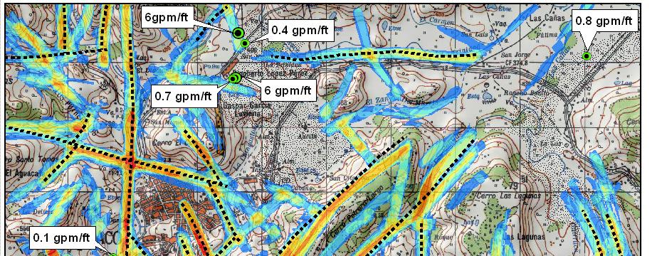
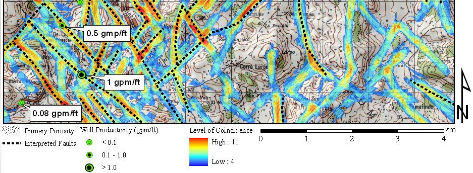
18 Mapped Faults in QAS Source:Radarsat Image 02/21/2003 Fault Maps: Villagómez, 2003

19 Tectonic control in the QAS Deformation in the Guayllabamba depression Villagomez, 2003
20 Structure of collaboration to study the QAS Universidad Central del Ecuador (UCE) INAHMI MTU EMAAP-Q Escuela Politécnica Nacional (EPN) University of Montpellier (Fr) IRD France
21 Outline Motivation Goals Objectives Setting Research Plan Methodology Intellectual merits and anticipated impacts
22 RESEARCH PLAN A A' Fractures Identified Using Satellite Remote Sensing Fractures Geometry (VLF-EM & Geoelectric Methods) / Faults / discontinuities Fracture characterization Geophysics Hydrochemistry, Isotope analysis, Existing data Exfiltration Infiltration A' ` Integration into Regional Hydrogeological Model


23 RS Lineament Mapping Select Imagery Types Digital Image Processing Initial Evaluation of Image Products Lineament Interpretation GIS Analysis Ground-truth Lineament Map Image Evaluation Lineaments derived from 30-m DEM * Methodology by Bruning, 2008


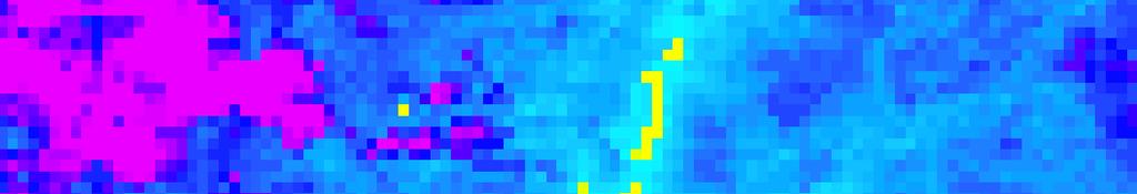

24 Thermal Bands Analysis Radiance High : Low : # 0 Cayambe ^_ NONO ^_ ^_ GUAYLLABAMBA QUITO Ilaló Volcano # 0 Antisana Kilometers 2.4 Aster Night Image TIR B10 (stretched) 2007/09/07

/(NIR")
 /")


25 RS-Thermal analysis INDEXES NDVI = (NIR- Red)/(NIR + Red) NDWI = (RNIR RSWIR) / (RNIR + RSWIR) High : High : Kilometers Low : Low :
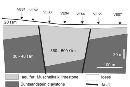

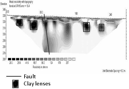
26 Geoelectrical Methods Limestone (aquifer) Claystone
27 Very Low Frequency-Electromagnetics (VLF-EM) Ratio* (%) * Between the vertical and the horizontal component Distance along a profile (m) Adapting from the WADI instruction manual, ABEM Instruments, Inc. In-phase Quadrature
28 Hydrochemistry (Ca,Mg) SO 4 (Ca,Mg) Cl 2 Fres h Mixing Sea Mg SO 4 Ca Fres h Na,K HCO 3 Fres h Sea Cl Piper Diagram and Hydrochemical Processes (Appelo, 1993)
29 Environmental Isotopes
30 Outline Motivation Goals Objectives Setting Research Plan Methodology Intellectual merits and anticipated impacts
31 Methodology Three phases approach Phase I Regional Hydrogeological Assessment Phase II Remote Sensed and Geophysics Based Hydrogeological Evaluation and Validation Phase III Remote Sensed and Geophysics Based Hydrogeological Evaluation
32 Phase I Topography and RS analysis Geology Analysis Evaluation of existing hydrogeology data Regional Conceptual Model A
33 Phase II Lineament / Discontinuities Mapping Hydrogeological Characterization of fracture, discontinuities and boundaries RS Assessment Geophysics Assessment Hydrochemistry /Isotope Assessment Hydraulic Assessment A Local Conceptual Model Existing models No Validation Yes Final Conceptual Model
34 Phase III Lineament Mapping Hydrogeological Evaluation of fracture, discontinuities and boundaries RS Assessment Geophysics Assessment Potential areas for detailed studies Local conceptual model Methodology For Remote Sensing Based Hydrogeological Evaluation
35 Scheme of collaboration for this project UCE & EPN Ves reinterpretation Hydraulic Analysis Hydrochemistry MTU Remote Sensing (MR) Regional Analysis (MR) Surface Geophysics MR/ATT EMAAP-Q Provide data Logistics Montpellier Univ. Isotope Lab Analysis Sharing data IRD /INAHMI Use similar methodologies in other regions of Ecuador
36 Motivation Goals Objectives Setting Research Plan Methodology Outline Expected outcomes
37 Desired Outcomes for RS Techniques Appropriateness for hydrogeological characterization in fractured aquifers Effectiveness & limitations for detecting faults, fractures, and discontinuities Influence of fracturing on hydrologic behavior
38 Desired Outcomes for RS Techniques Demonstrate the importance of including remote sensing techniques in regional hydrogeological analysis for water resources evaluation and management Effectiveness of international collaboration for complex hydrogeological studies
39 Questions?
IDENTIFICATION OF GEOLOGIC LINEAMENTS AND GROUNDWATER FLOW SYSTEMS, USING DIGITAL ELEVATION MODELS, SATELLITE IMAGERY, AND SPRING. Miriam Rios-Sanchez
 IDENTIFICATION OF GEOLOGIC LINEAMENTS AND GROUNDWATER FLOW SYSTEMS, USING DIGITAL ELEVATION MODELS, SATELLITE IMAGERY, AND SPRING DATA IN QUITO, ECUADOR Miriam Rios-Sanchez PROBLEM STATEMENT Quito area
Scientific Research Outcome Report
 Scientific Research Outcome Report Prefeasibility study for 1MW Geothermal Power Generation in Gujarat, India 1. Faculty Name: Dr. B. K. Behera 2. Branch / Department: School of Petroleum Technology (SPT)
The Geology and Hydrogeology of the Spyhill Area
 The Geology and Hydrogeology of the Spyhill Area Clare North (WorleyParsons Komex) and Martin Ortiz (The City of Calgary) 2-Jul-08 Outline Background Site Location Existing Information New Work Geology
DATA ACQUISITION METHODS FOR GROUNDWATER INVESTIGATION AND THE SITING OF WATER SUPPLY WELLS
 DATA ACQUISITION METHODS FOR GROUNDWATER INVESTIGATION AND THE SITING OF WATER SUPPLY WELLS M.B.J. Foster Tetra Tech EM Inc., San Francisco, CA, USA Keywords: Groundwater, water wells, drilled wells, geophysical
Does the SDCP need inputs from geology?
 The British Geological Survey s Experience and Expertise in Supporting Projects such as the Sirte Depression Connection Project David Ovadia Director of International Kingsley Dunham Centre Keyworth Nottingham
Basin Analysis Applied to Modelling Buried Valleys in the Great Lakes Basin
 EARTH SCIENCES SECTOR GENERAL INFORMATION PRODUCT 35 Basin Analysis Applied to Modelling Buried Valleys in the Great Lakes Basin Sharpe, D R; Russell, H A J 2004 Originally released as: Basin Analysis
11/22/2010. Groundwater in Unconsolidated Deposits. Alluvial (fluvial) deposits. - consist of gravel, sand, silt and clay
 deposits. - consist of gravel, sand, silt and clay") Groundwater in Unconsolidated Deposits Alluvial (fluvial) deposits - consist of gravel, sand, silt and clay - laid down by physical processes in rivers and flood plains - major sources for water supplies
Groundwater in Unconsolidated Deposits Alluvial (fluvial) deposits - consist of gravel, sand, silt and clay - laid down by physical processes in rivers and flood plains - major sources for water supplies
the Quarrying Industry Dewatering and the Quarrying Industry the Quarrying Industry
 Dewatering and the Quarrying Industry Dewatering and Dewatering and the Quarrying Industry the Quarrying Industry Les Brown Eugene P. Daly John Kelly Objectives 1) To present a summary of water management
CHAPTER 9 SUMMARY AND CONCLUSIONS
 CHAPTER 9 SUMMARY AND CONCLUSIONS The following are the important conclusions and salient features of the present study. 1. The evaluation of groundwater potential is a prerequisite for any kind of planning
HYDRO-CHEMICAL AND STABLE ISOTOPE PROPERTIES OF GROUNDWATER IN MT. KARANG, WEST JAVA, INDONESIA
 HYDRO-CHEMICAL AND STABLE ISOTOPE PROPERTIES OF GROUNDWATER IN MT. KARANG, WEST JAVA, INDONESIA Boy Yoseph CSS SYAH ALAM1, Ryuichi ITOI2 and Sachihiro TAGUCHI3 1 2 Facultyof Geology, Padjadjaran University,
b Blackwell Science Environmental Geology PRINCIPLES AND PRACTICE
 Environmental Geology PRINCIPLES AND PRACTICE Fred G. Bell Department of Geology and Applied Geology University of Natal, Durban, South Africa b Blackwell Science Preface, ix 1 Introduction, 1 1.1 Planning
B. T. Brady, M. S. Bedinger, John Mikels, William H. Langer, and Deborah A. Mulvihill
 DEPARTMENT OF THE INTERIOR UNITED STATES GEOLOGICAL SURVEY TO ACCOMPANY WRI REPORT 83-4121-B MAP SHOWING GROUND-WATER LEVELS, SPRINGS. AND DEPTH TO GROUND WATER, BASIN AND RANGE PROVINCE, TEXAS by B. T.
Evolution of the conceptual hydrogeologic and ground-water flow model for Las Vegas Valley, Clark County, Nevada
 Evolution of the conceptual hydrogeologic and ground-water flow model for Las Vegas Valley, Clark County, Nevada Geological Society of America Annual Meeting November 14, 2 David J. Donovan Southern Nevada
ambiguity in earth sciences IESO Geophysics Section Eddy hartantyo, Lab Geofisika FMIPA UGM
 ambiguity in earth sciences IESO Geophysics Section Eddy hartantyo, Lab Geofisika FMIPA UGM Pelatihan Tahap II IESO Teknik Geologi UGM Februari 2009 1 Introduction Photos from http://www.eegs.org/whatis/
Application of Remote Sensing and Geo-Electrical Method for Groundwater Exploration in Khor Al Alabyad, North Kordofan State, Sudan
 American Journal of Earth Sciences 2015; 2(6): 242-246 Published online January 10, 2016 (http://www.openscienceonline.com/journal/ajes) ISSN: 2381-4624 (Print); ISSN: 2381-4632 (Online) Application of
Soils, Hydrogeology, and Aquifer Properties. Philip B. Bedient 2006 Rice University
 Soils, Hydrogeology, and Aquifer Properties Philip B. Bedient 2006 Rice University Charbeneau, 2000. Basin Hydrologic Cycle Global Water Supply Distribution 3% of earth s water is fresh - 97% oceans 1%
Mathematical model of Baltic artesian basin
 Mathematical model of Baltic artesian basin Juris Sennikovs, Janis Virbulis, and Uldis Bethers Laboratory for Mathematical Modelling of Environmental and Technological Processes UNIVERSITY OF LATVIA Contents
Instructional Objectives
 GE 6477 DISCONTINUOUS ROCK 8. Fracture Detection Dr. Norbert H. Maerz Missouri University of Science and Technology (573) 341-6714 norbert@mst.edu Instructional Objectives 1. List the advantages and disadvantages
Geochemistry, Geophysics, Geosystems. Supporting Information for
 1 2 3 4 5 6 7 8 Geochemistry, Geophysics, Geosystems Supporting Information for Volcano Deformation Survey over the Northern and Central Andes with ALOS InSAR Time Series Anieri M. Morales Rivera 1, Falk
Geo-hazard Potential Mapping Using GIS and Artificial Intelligence
 Geo-hazard Potential Mapping Using GIS and Artificial Intelligence Theoretical Background and Uses Case from Namibia Andreas Knobloch 1, Dr Andreas Barth 1, Ellen Dickmayer 1, Israel Hasheela 2, Andreas
Delineation of Groundwater Potential Zone on Brantas Groundwater Basin
 Delineation of Groundwater Potential Zone on Brantas Groundwater Basin Andi Rachman Putra 1, Ali Masduqi 2 1,2 Departement of Environmental Engineering, Sepuluh Nopember Institute of Technology, Indonesia
Geothermal Exploration in Eritrea
 Geothermal Exploration in Eritrea Short Course III on Exploration for Geothermal Resources November 2008, Naivasha, Kenya Ermias Yohannes Berhane Ermias_yohannes@yahoo.com Ministry of Energy and Mines
CAPE Unit 1 Module 2 & 3. Topic Specific Objectives Content Explain the main concepts, flows and processes associated with coastal environments
 # Week(s) Wks 1-3 CAPE Unit 1 Module 2 & 3 Topic Specific Objectives Content Explain the main concepts, flows and processes associated with coastal environments Wave formation, structure, types Textbook
Hydrogeology of the San Agustin Plains
 Hydrogeology of the San Agustin Plains Alex Rinehart, Daniel Koning and Stacy Timmons New Mexico Bureau of Geology New Mexico Tech 16 August 2017 62nd New Mexico Water Conference Acknowledgments Community
HYDROGEOLOGICAL CONCEPTUAL MODEL OF A COMPLEX AQUIFER SYSTEM CENTRAL KALAHARI BASIN (BOTSWANA) DATE: 27 OCTOBER 2016 VENUE: GICC
 DATE: 27 OCTOBER 2016 VENUE: GICC") HYDROGEOLOGICAL CONCEPTUAL MODEL OF A COMPLEX AQUIFER SYSTEM CENTRAL KALAHARI BASIN (BOTSWANA) DATE: 27 OCTOBER 2016 VENUE: GICC MR. M. LEKULA DR. M.W. LUBCZYNSKI PROF. E.M. SHEMANG PRESENTATION OUTLINE
HYDROGEOLOGICAL CONCEPTUAL MODEL OF A COMPLEX AQUIFER SYSTEM CENTRAL KALAHARI BASIN (BOTSWANA) DATE: 27 OCTOBER 2016 VENUE: GICC MR. M. LEKULA DR. M.W. LUBCZYNSKI PROF. E.M. SHEMANG PRESENTATION OUTLINE
Airborne Geophysics to Map Groundwater. Bill Brown
 Airborne Geophysics to Map Groundwater Bill Brown bb@skytem.com A 6 borehole represents 1 millionth of an acre Aquifer Materials An aquifer is an underground layer of water bearing permeable rock, rock
Geoscience 001 Fall Rock Identification and Contextual Interpretation
 Geoscience 00 Fall 2005 Rock Identification and Contextual Interpretation The purpose of this week s lab is to gain some more experience and practice in identifying rocks and then interpreting the geologic
Impact of the Danube River on the groundwater dynamics in the Kozloduy Lowland
 GEOLOGICA BALCANICA, 46 (2), Sofia, Nov. 2017, pp. 33 39. Impact of the Danube River on the groundwater dynamics in the Kozloduy Lowland Peter Gerginov Geological Institute, Bulgarian Academy of Sciences,
RESISTIVITY IMAGING AND BOREHOLE INVESTIGATION OF THE BANTING AREA AQUIFER, SELANGOR, MALAYSIA. A.N. Ibrahim Z.Z.T. Harith M.N.M.
 JOURNAL OF ENVIRONMENTAL HYDROLOGY The Electronic Journal of the International Association for Environmental Hydrology On the World Wide Web at http://www.hydroweb.com VOLUME 11 2003 RESISTIVITY IMAGING
Groundwater Sustainability at Wadi Al Bih Dam, Ras El Khaimah, United Arab Emirates (UAE) using Geophysical methods
 using Geophysical methods") Groundwater Sustainability at Wadi Al Bih Dam, Ras El Khaimah, United Arab Emirates (UAE) using Geophysical methods Ahmed Murad, Amir Gabr, Saber Mahmoud, Hasan Arman & Abdulla Al Dhuhoori Geology Department
Groundwater Sustainability at Wadi Al Bih Dam, Ras El Khaimah, United Arab Emirates (UAE) using Geophysical methods Ahmed Murad, Amir Gabr, Saber Mahmoud, Hasan Arman & Abdulla Al Dhuhoori Geology Department
PALLAVI CHATTOPADHYAY
 Dr. (Mrs.) PALLAVI CHATTOPADHYAY Assistant Professor Department of Earth Sciences Indian Institute of Technology Roorkee-247667, Uttarakhand, India E-mail: cpallavi.fes@iitr.ac.in/vns_pal@yahoo.co.in Contact
PROANA A USEFUL SOFTWARE FOR TERRAIN ANALYSIS AND GEOENVIRONMENTAL APPLICATIONS STUDY CASE ON THE GEODYNAMIC EVOLUTION OF ARGOLIS PENINSULA, GREECE.
 PROANA A USEFUL SOFTWARE FOR TERRAIN ANALYSIS AND GEOENVIRONMENTAL APPLICATIONS STUDY CASE ON THE GEODYNAMIC EVOLUTION OF ARGOLIS PENINSULA, GREECE. Spyridoula Vassilopoulou * Institute of Cartography
Remote sensing, GIS and groundwater exploration
 Remote sensing, GIS and groundwater exploration Geraint Burrows CEO of Groundwater Relief 4 th United Nations / Pakistan / Prince Sultan Bin Abdulaziz International Prize for Water International Conference
PROJECT LIST BY COUNTRY
 PROJECT LIST BY COUNTRY COUNTRY PROJECT NO. TITLE DATE BANGLADESH 16 HYDROGEOLOGY Well Design 36 GEOPHYSICAL STUDIES Digitisation and interpretation of BGS overseas gravity and aeromagnetic data 04/1982
LAND DEGRADATION IN THE CARIBBEAN: QUATERNARY GEOLOGICAL PROCESSES. RAFI AHMAD
 EXTENDED TASK FORCE MEETING OF PARTICIPATING AGENCIES AND LATIN AMERICAN COUNTRIES FOR ENHANCING SOUTH-SOUTH COOPERATION BETWEEN LAC-CARIBBEAN SIDS PARTNERSHIP INITIATIVE ON LAND DEGRADATION AND SUSTAINABLE
Late Pleistocene - Holocene climate variations over central Europe reconstructed from groundwater data
 Late Pleistocene - Holocene climate variations over central Europe reconstructed from groundwater data J.A. Corcho Alvarado Institute of Radiation Physics, Univ. Hospital and Univ. of Lausanne, Switzerland
NEW DIAGRAM USEFUL FOR CLASSIFICATION OF GROUNDWATER QUALITY
 NEW DIAGRAM USEFUL FOR CLASSIFICATION OF GROUNDWATER QUALITY Elhag A.B Department of Civil Engineering, College of Engineering, King Khalid University, Saudi ABSTRACT: Due to human and human activities
STATE UNIVERSITY OF NEW YORK COLLEGE OF TECHNOLOGY CANTON, NEW YORK
 STATE UNIVERSITY OF NEW YORK COLLEGE OF TECHNOLOGY CANTON, NEW YORK COURSE OUTLINE ESCI 107 Earth Science Prepared By: Adrienne C. Rygel, Ph.D. CANINO SCHOOL OF ENGINEERING TECHNOLOGY Department of Construction
Electrical Resistivity Survey for Delineating Seawater Intrusion in a Coastal Aquifer
 Electrical Resistivity Survey for Delineating Seawater Intrusion in a Coastal Aquifer Sung-Ho Song*, Gyu-Sang Lee*, Jin-Sung Kim*, Baekuk Seong*, Young-gyu Kim*, Myung-Ha Woo* and Namsik Park** Abstract
OPV s.r.o., Praha, Czech Republic. Córdoba, C
 Arsenic enrichment of ground water at two regions of the Chacopampean plain, northwest Argentina Ondra Sracek 1,2, María Gabriela GarcG arcía 3 1 OPV s.r.o., Praha, Czech Republic 2 Pontificia Universidade
ENVIRONMENTAL GEOSCIENCE UNIFORM SYLLABUS
 ENVIRONMENTAL GEOSCIENCE UNIFORM SYLLABUS The Association of Professional Engineers and Geoscientists of the Province of British Columbia Note: 1. This Syllabus May Be Subject To Change 2. These Courses
Remote Sensing for Hazard Mitigation and Resource Protection in Pacific Latin America
 Remote Sensing for Hazard Mitigation and Resource Protection in Pacific Latin America Project Overview PIRE 0530109 Develop great international research partnerships Train globally engaged workforce Improve
Down-stream process transition (f (q s ) = 1)
 = 1)") Down-stream process transition (f (q s ) = 1) Detachment Limited S d >> S t Transport Limited Channel Gradient (m/m) 10-1 Stochastic Variation { Detachment Limited Equilibrium Slope S d = k sd A -θ d S
Down-stream process transition (f (q s ) = 1) Detachment Limited S d >> S t Transport Limited Channel Gradient (m/m) 10-1 Stochastic Variation { Detachment Limited Equilibrium Slope S d = k sd A -θ d S
NAME OF THE PROGRAMME : M.Sc. GEOLOGY PROGRAMME OUTCOME
 NAME OF THE PROGRAMME : M.Sc. GEOLOGY PROGRAMME OUTCOME 1. Understanding development of landforms through Earth's external processes by various geological agents; marine processes and formation of marine
2 Geology. 2.1 Elements of Terrane Analysis. Terrane or Terrain? Potential receptors
 2 Geology Knowledge of fractured rock geology, or terrane, provides important context for investigating contaminated sites. Tectonic forces impart characteristic structures on rock formations that influence
A Preliminary Geophysical Reconnaissance Mapping of Emirau Ground Water Resource, Emirau Island, New Ireland Province, PNG
 A Preliminary Geophysical Reconnaissance Mapping of Emirau Ground Water Resource, Emirau Island, New Ireland Province, PNG Geological Survey Division of Mineral Resources Authority (MRA) Papua New Guinea
Before Plate Tectonics: Theory of Continental Drift
 Before Plate Tectonics: Theory of Continental Drift Predecessor to modern plate tectonics Shape and fit of the continents was the initial evidence Snider-Pelligrini (1858) Taylor (1908) Wegner (1915) Fig.
Springshed Springshed Management Training Curriculum
 Springshed Springshed Management Training Curriculum Management Training Curriculum Draft Version 2 January 2016 The Springs Initiative 2016 The Springs Initiative SESSION TITLE: Mapping Springs in Crystalline
Hydrogeology of East-Central Union County, Northeastern New Mexico
 Hydrogeology of East-Central Union County, Northeastern New Mexico Geoffrey Rawling April 2013 New Mexico Bureau of Geology & Mineral Resources 1 What are the important hydrogeologic issues in Union County?
Exploration of Geothermal High Enthalpy Resources using Magnetotellurics an Example from Chile
 Exploration of Geothermal High Enthalpy Resources using Magnetotellurics an Example from Chile Ulrich Kalberkamp, Federal Institute for Geosciences and Natural Resources (BGR), Stilleweg 2, 30655 Hannover,
Finding Large Capacity Groundwater Supplies for Irrigation
 Finding Large Capacity Groundwater Supplies for Irrigation December 14, 2012 Presented by: Michael L. Chapman, Jr., PG Irrigation Well Site Evaluation Background Investigation Identify Hydrogeologic Conditions
SEASONAL WATER STORAGE AND REPLENISHMENT OF A FRACTURED GRANITE AQUIFER USING ASR WELLS
 SEASONAL WATER STORAGE AND REPLENISHMENT OF A FRACTURED GRANITE AQUIFER USING ASR WELLS Mario R. Lluria; Phillip M. Paski; Gary G. Small HydroSystems, Incorporated Phoenix, Arizona USA Presentation Contents
ASTER DEM Based Studies for Geological and Geomorphological Investigation in and around Gola block, Ramgarh District, Jharkhand, India
 International Journal of Scientific & Engineering Research, Volume 3, Issue 2, February-2012 1 ASTER DEM Based Studies for Geological and Geomorphological Investigation in and around Gola block, Ramgarh
Prepared By: John Blair Sean Donahue Celeste Hoffman Kimberly Klinkers Megan Slater
 Prepared By: John Blair Sean Donahue Celeste Hoffman Kimberly Klinkers Megan Slater Green River Basin Location Green River Basin Stratigraphic Correlation Chart showing Study Map Units Sample of Existing
A NOVEL APPROACH TO GROUNDWATER MODEL DEVELOPMENT. Thomas D. Krom 1 and Richard Lane 2
 A NOVEL APPROACH TO GROUNDWATER MODEL DEVELOPMENT Thomas D. Krom 1 and Richard Lane 2 1 Touch Water Ltd., P.O. Box 143, Lincoln, Christchurch, New Zealand; email: touchwater@gmail.com 2 Applied Research
EASTERN ARIZONA COLLEGE Physical Geology
 EASTERN ARIZONA COLLEGE Physical Geology Course Design 2016-2017 Course Information Division Science Course Number GLG 101 (SUN# 1101) Title Physical Geology Credits 4 Developed by David Morris Lecture/Lab
GEOTHERMAL ENERGY POTENTIAL FOR LONGONOT PROSPECT, KENYA. By Mariita N. O. Kenya Electricity Generating Company
 GEOTHERMAL ENERGY POTENTIAL FOR LONGONOT PROSPECT, KENYA By Mariita N. O. Kenya Electricity Generating Company PRESENTATION OUTLINE INTRODUCTION REGIONAL SETTING GEOLOGY GEOTHERMAL MANIFESTATIONS HYDROGEOLOGY
Geothermal Exploration in Eritrea
 Geothermal Exploration in Eritrea Ermias Yohannes, Eritrea Ministry of Energy and Mines, Department of Mines ermias_yohannes@yahoo.com Short Course on Surface Exploration for Geothermal Resources UNU-GTP
1.72, Groundwater Hydrology Prof. Charles Harvey Lecture Packet #5: Groundwater Flow Patterns. Local Flow System. Intermediate Flow System
 1.72, Groundwater Hydrology Prof. Charles Harvey Lecture Packet #5: Groundwater Flow Patterns c Local Flow System 10,000 feet Intermediate Flow System Regional Flow System 20,000 feet Hydrologic section
From Punchbowl to Panum: Long Valley Volcanism and the Mono-Inyo Crater Chain
 From Punchbowl to Panum: Leslie Schaffer E105 2002 Final Paper Long Valley Volcanism and the Mono-Inyo Crater Chain Figure 1. After a sequence of earthquakes during the late 1970 s to the early 1980 s
ENVIRONMENTAL EFFECTS OF GROUNDWATER WITHDRAWAL IN SOUTH NYÍRSÉG
 PhD thesis ENVIRONMENTAL EFFECTS OF GROUNDWATER WITHDRAWAL IN SOUTH NYÍRSÉG János Szanyi Szeged, 2004 ENVIRONMENTAL EFFECTS OF GROUNDWATER WITHDRAWAL IN SOUTH NYÍRSÉG Preliminaries, the aims of the dissertation
DIGITAL IMAGERY AND GEOLOGIC MAP OF CHEGEM CALDERA, RUSSIA
 DIGITAL IMAGERY AND GEOLOGIC MAP OF CHEGEM CALDERA, RUSSIA Christina Cauley Department of Geology and Anthropology University of Hawai i at Hilo Hilo, HI 96720 ABSTRACT The late Pliocene Chegem Caldera
!!!!! STOP!!!!! What is environmental geology? Earth as a closed system implies nearly everything is cycled, recycled
 What is environmental geology?!!!!! STOP!!!!! Geology Study of rocks and minerals that comprise earth s surface and interior and the natural processes that shape the earth s surface and interior over all
!!!!! STOP!!!!! What is environmental geology?
 !!!!! STOP!!!!! What is environmental geology? Geology Study of rocks and minerals that comprise earth s surface and interior and the natural processes that shape the earth s surface and interior over
RESISTIVITY IMAGING IN EASTERN NEVADA USING THE AUDIOMAGNETOTELLURIC METHOD FOR HYDROGEOLOGIC FRAMEWORK STUDIES. Abstract.
 RESISTIVITY IMAGING IN EASTERN NEVADA USING THE AUDIOMAGNETOTELLURIC METHOD FOR HYDROGEOLOGIC FRAMEWORK STUDIES Darcy K. McPhee, U.S. Geological Survey, Menlo Park, CA Louise Pellerin, Green Engineering,
Hydro-Geophysical Investigation of the Federal Housing Estate Akure, Southwestern Nigeria
 Journal of Emerging Trends in Engineering and Applied Sciences (JETEAS) 4(6): 793-799 Scholarlink Research Institute Journals, 2013 (ISSN: 2141-7016) jeteas.scholarlinkresearch.org Journal of Emerging
Mountains are then built by deforming crust: Deformation & Mountain Building. Mountains form where stresses are high!
 Deformation & Mountain Building Where are mountains located? Deformation and Folding Mountain building Mountains form where stresses are high! Mountains form at all three types of plate boundaries where
Course Description. Course Objectives and Standards
 Earth and Space Science Curriculum Course Description Earth and Space Science 1 State # 3044 Grades offered: 10-12 Credits: A two credit course Prerequisite: none Counts as a Science Course for the General,
Application of Aquifer Vulnerability Index (AVI) method to assess groundwater vulnerability to contamination in Semarang urban area
 method to assess groundwater vulnerability to contamination in Semarang urban area") Application of Aquifer Vulnerability Index (AVI) method to assess groundwater vulnerability to contamination in Semarang urban area Thomas Triadi Putranto 1*, Narulita Santi 1, Dian Agus Widiarso 1, and
Application of Aquifer Vulnerability Index (AVI) method to assess groundwater vulnerability to contamination in Semarang urban area Thomas Triadi Putranto 1*, Narulita Santi 1, Dian Agus Widiarso 1, and
Construction Technical Specifications on Rock-Foundation Excavating Engineering of Hydraulic Structures
 DL Electric Power Industry Standard of the People's Republic of China P DL I T 5389-- Construction Technical Specifications on Rock-Foundation Excavating Engineering of Hydraulic Structures DL/T 5389-
2008 JC2 H2 GEOGRAPHY: PIONEER JUNIOR COLLEGE PRELIMINARY EXAMS. Figure 1 for Question 1
 PHYSICAL GEOGRAPHY Figure 1 for Question 1 Figure 2 for Question 2 Tropical air mass source regions Figure 3 for Question 3 Figure 4 for Question 4 Volcanic gases Figure 5 for Question 5 EITHER Photograph
ESRI GIS For Mining Seminar, 10 th August, 2016, Nairobi, Kenya. Spatial DATA Solutions for Mining
 ESRI GIS For Mining Seminar, 10 th August, 2016, Nairobi, Kenya Spatial DATA Solutions for Mining Spatial Data Solutions for Mining Spatial - Data that identifies the geographic location of features &
Structural Geology Laboratory.
 Structural Geology Wikipedia-Structural geology is the study of the threedimensional distribution of rock units with respect to their deformational histories. The primary goal of structural geology is
GEOLOGY (GEOL) Geology (GEOL) 1. GEOL 118 Societal Issues in Earth Science (4 crs)
 Geology (GEOL) 1. GEOL 118 Societal Issues in Earth Science (4 crs)") Geology (GEOL) 1 GEOLOGY (GEOL) GEOL 102 Oceanography (3 crs) Survey of the world oceans with emphasis on geologic processes. Also includes chemical, physical, and biological aspects of the sea. Investigates
Geology (GEOL) 1 GEOLOGY (GEOL) GEOL 102 Oceanography (3 crs) Survey of the world oceans with emphasis on geologic processes. Also includes chemical, physical, and biological aspects of the sea. Investigates
Section 5. Rock Units and Your Community. What Do You See? Think About It. Investigate. Learning Outcomes
 Chapter 3 Minerals, Rocks, and Structures Section 5 Rock Units and Your Community What Do You See? Learning Outcomes In this section, you will Recognize that rocks are arranged in Earth s crust as well-defined
Springshed Springshed Management Training Curriculum
 Springshed Springshed Management Training Curriculum Management Training Curriculum Draft Version 2 January 2016 The Springs Initiative 2016 The Springs Initiative SESSION TITLE: Section Mapping SECTION:
A multitechnique approach to the dynamics of thermal waters ascribed to a granitic hard rock environment (Serra da Estrela, Central Portugal)
") A multitechnique approach to the dynamics of thermal waters ascribed to a granitic hard rock environment (Serra da Estrela, Central Portugal) J. M. Marques 1, P. M. Carreira 2, J. Espinha Marques 3, H.
A multitechnique approach to the dynamics of thermal waters ascribed to a granitic hard rock environment (Serra da Estrela, Central Portugal) J. M. Marques 1, P. M. Carreira 2, J. Espinha Marques 3, H.
GEOSENSE - GEOLOGICAL MAPPING
 GEOSENSE - GEOLOGICAL MAPPING Whatever the terrain you re working in (from desert to arctic to tropical jungle), whatever the tectonic setting, Geosense has undertaken geological mapping in similar regions.
Technical Requirements of Geothermal Exploration in the RSM DADI THORBJORNSON, RSM CONSULTANT WORKSHOP SWISS HOTEL IZMIR 5 JULY 2018
 Technical Requirements of Geothermal Exploration in the RSM DADI THORBJORNSON, RSM CONSULTANT WORKSHOP SWISS HOTEL IZMIR 5 JULY 2018 JV Partners Engineering firm with hundred twenty years of experience
Geophysical Exploration in Water Resources Assessment. John Mundell, P.E., L.P.G., P.G. Ryan Brumbaugh, L.P.G. Mundell & Associates, Inc.
 Geophysical Exploration in Water Resources Assessment John Mundell, P.E., L.P.G., P.G. Ryan Brumbaugh, L.P.G. Mundell & Associates, Inc. Presentation Objective Introduce the use of geophysical survey methods
The Seattle-area geologic mapping project and the geologic framework of Seattle
 The Seattle-area geologic mapping project and the geologic framework of Seattle Troost, K.G., D.B. Booth, S.A. Shimel, and M.A. O Neal, Univ. of Washington, Seattle 98195 Introduction The Puget Lowland
Satellite Based Seismic Technology
 Satellite Based Seismic Technology Dr. V.K. Srivastava, R. Ghosh*, B.B Chhualsingh Department of Applied Geophysics, Indian School of mines, Dhanbad. E- mail: ismkvinay@hotmail.com, ghosh.ramesh@rediffmail.com,
LEMBAGA PENERBANGAN DAN ANTARIKSA NASIONAL INDONESIAN NATIONAL INSTITUTE OF AERONAUTICS AND SPACE (LAPAN)
") LEMBAGA PENERBANGAN DAN ANTARIKSA NASIONAL INDONESIAN NATIONAL INSTITUTE OF AERONAUTICS AND SPACE (LAPAN) The Utilization of Remotely Sensed Data to Analyze The Estimated Volume of Pyroclastic Deposits
LEMBAGA PENERBANGAN DAN ANTARIKSA NASIONAL INDONESIAN NATIONAL INSTITUTE OF AERONAUTICS AND SPACE (LAPAN) The Utilization of Remotely Sensed Data to Analyze The Estimated Volume of Pyroclastic Deposits
Do Now: Vocabulary: Objectives. Vocabulary: 1/5/2016. Wegener? (Can they move?) the idea that continents have moved over time?
 the idea that continents have moved over time?") Do Now: 1. Who was Alfred Wegener? 2. What was Pangaea? 3. Are continents fixed? (Can they move?) 4. What evidence supports the idea that continents have moved over time? Objectives What evidence suggests
Do Now: 1. Who was Alfred Wegener? 2. What was Pangaea? 3. Are continents fixed? (Can they move?) 4. What evidence supports the idea that continents have moved over time? Objectives What evidence suggests
Groundwater from ophiolite aquifer: flow path and recharge rate
 Groundwater from ophiolite aquifer: flow path and recharge rate Rashid Al Abri 1,2, Osman Abdalla 2 and Khadija Semhi 2 1 Ministry of Regional Municipalities and Water Resources, Muscat, Oman 2 Dept. of
Groundwater Level Monitoring of the Quaternary Aquifer at Al Ain City, United Arab Emirates (UAE) using Geophysical Methods
 using Geophysical Methods") Groundwater Level Monitoring of the Quaternary Aquifer at Al Ain City, United Arab Emirates (UAE) using Geophysical Methods Ahmed Murad & Amir Gabr Geology Department UAE University Outlines Introduction
Groundwater Level Monitoring of the Quaternary Aquifer at Al Ain City, United Arab Emirates (UAE) using Geophysical Methods Ahmed Murad & Amir Gabr Geology Department UAE University Outlines Introduction
Land subsidence due to groundwater withdrawal in Hanoi, Vietnam
 Land Subsidence (Proceedings of the Fifth International Symposium on Land Subsidence, The Hague, October 1995). 1AHS Publ. no. 234, 1995. 55 Land subsidence due to groundwater withdrawal in Hanoi, Vietnam
Overview of Geoscience Employers Workshop Outcomes
 Overview of Geoscience Employers Workshop Outcomes General thoughts on concepts: From Geoscience Employers Workshop Systems Thinking How systems work and interact Processes Atmosphere: Climate, Weather,
1.0 Introduction 1.1 Geographic Location 1.2 Topography 1.3 Climate and Rainfall 1.4 Geology and Hydrogeology 1.5 Water Availability 1.
 1.0 1.1 Geographic Location 1.2 Topography 1.3 Climate and Rainfall 1.4 Geology and Hydrogeology 1.5 Water Availability 1.6 Demography 1.0 1.1 Geographic Location St. Lucia forms part of an archipelago
IMPACT OF CLIMATE CHANGE OVER THE ARABIAN PENINSULA
 IMPACT OF CLIMATE CHANGE OVER THE ARABIAN PENINSULA By: Talal Alharbi June, 29 2017 1 Motivation: In arid and semi-arid regions of the world the demand for fresh water resources is increasing due to: increasing
MESOZOIC BASINS. North Carolina Geological Survey
 MESOZOIC BASINS North Carolina Geological Survey The 1823 organic act which created the North Carolina Geological Survey (NCGS) tasked us to examine, describe and map the geology, geologic hazards, and
Downloaded from Downloaded from
 IV SEMESTER BACK-PAPER EXAMINATION-2004 Q. [1] [a] Describe internal structure of the earth with a neat sketch. Write down the major land forms and their characteristics on the earth surface. [8] [b] What
4.11 Groundwater model
 4.11 Groundwater model 4.11 Groundwater model 4.11.1 Introduction and objectives Groundwater models have the potential to make important contributions in the mapping and characterisation of buried valleys.
Virtual Fieldwork Experience (VFE): SP Crater near Flagstaff, Arizona
: SP Crater near Flagstaff, Arizona") Virtual Fieldwork Experience (VFE): SP Crater near Flagstaff, Arizona Before you start Review what you already know about volcanoes (knowledge needed to complete this VFE): If you don t know these off
Virtual Fieldwork Experience (VFE): SP Crater near Flagstaff, Arizona Before you start Review what you already know about volcanoes (knowledge needed to complete this VFE): If you don t know these off
On the sources of salinity in groundwater under plain areas. Insights from δ 18 O, δ 2 H and hydrochemistry in the Azul River basin, Argentina
 On the sources of salinity in groundwater under plain areas. Insights from δ 18 O, δ 2 H and hydrochemistry in the Azul River basin, Argentina M.E. Zabala a, M. Manzano b, M. Varni a, P. Weinzettel a a
THE ZUNIL-II GEOTHERMAL FIELD, GUATEMALA, CENTRAL AMERICA
 THE ZUNIL-II GEOTHERMAL FIELD, GUATEMALA, CENTRAL AMERICA Enrique M. Lima Lobato 1 and Julio Palma 2 1 West Japan Engineering Consultants, Inc., 1-82, 2-Chome, Watanabe-dori, Chuo-ku, Fukuoka 810-0004,
Water Framework Directive. Groundwater Monitoring Programme. Site Information. Tir na League
 Water Framework Directive Groundwater Monitoring Programme Site Information Tir na League ImagePath1: Tir na League\IE_NW_G_078_05_005_ A_PumpHouse.jpg Tir na League is an infiltration gallery situated
Section 11.1 pp Where Mountains Form
 Section 11.1 pp. 236 237 Where Mountains Form Chapter 11 Set a Purpose: TE, p. 236 Reading Study Guide, p. 36 Discussion: TE, p. 236 Differentiating ion Reading Support: TE, p. 236 Visual Teaching Interpret
Julie Fero NRS 509. Mapping Volcanic Risk with GIS
 Julie Fero NRS 509 Mapping Volcanic Risk with GIS Introduction Volcanoes are present throughout the world, generally occurring along plate margins, making the entire world prone to volcanic influence,
Geothermal Development and Research in Chile: the Andean Geothermal Center of Excellence (CEGA)
") ALCUE NET Salta, Argentina 9-12 December 2014 Geothermal Development and Research in Chile: the Andean Geothermal Center of Excellence Dr. Diego Morata Dpto Geología & CEGA Director Fac. Cs Físicas y Matemáticas
ALCUE NET Salta, Argentina 9-12 December 2014 Geothermal Development and Research in Chile: the Andean Geothermal Center of Excellence Dr. Diego Morata Dpto Geología & CEGA Director Fac. Cs Físicas y Matemáticas