A High Resolution Vertical Gradient Approach for Delineation of Hydrogeologic Units at a Contaminated Sedimentary Rock Field Site
|
|
|
- Gwendolyn Hancock
- 5 years ago
- Views:
Transcription


1 A High Resolution Vertical Gradient Approach for Delineation of Hydrogeologic Units at a Contaminated Sedimentary Rock Field Site Jessica Meyer Solinst Symposium High Resolution, Depth-Discrete Groundwater Monitoring - Benefits & Importance Georgetown, Ontario November 7, 2013
2 DNAPL Fractured Rock Site in Southern Wisconsin Contamination in a fractured sandstone Multicomponent DNAPL source zone Dissolved phase plume ~ 3 km long


3 Mixed Organic Contaminants Plume in Fractured Sandstone 154 monitoring locations DNAPL Source Area ~ 72,000 L DNAPL 20 multilevel systems Total of 558 monitoring points Flow generally toward east to southeast Flow Plume ~ 2.8 km long in 2003

4 Pleistocene Unconsolidated Sediments Cambrian/Ordovician Sedimentary Bedrock DNAPL Most laterally extensive dissolved phase plume Local Aquifer Regional Aquitard Regional Aquifer

5 Objectives High resolution hydraulic basis for delineation of hydrogeologic units High resolution characterization of the mass distribution
6 Hydrogeologic Units (HGUs) Represent partitions of the groundwater flow domain with contrasting hydraulic conductivities
7 Why are HGUs Important Used as a framework for ALL conceptual and numerical models of groundwater flow and contaminant transport

8 Position All Groundwater Studies Require Delineation of HGUs Thickness Lateral Extent/geometry


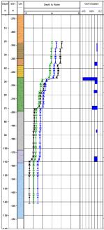
9 Depth Hypothesis High resolution head profiles identify the position / thickness of K v contrasts that can be used to delineate HGUs Head K = 100 Inflection K = 1 K = 100 K = 1 K = 100 Meyer PhD, 2013

")


10 Discrete Fracture Network (DFN) Approach to Site Characterization Drill Corehole Core Corehole Geology / Fractures Contaminant Analysis Physical / Chemical Properties Geophysics/ Hydrophysics Hydraulic Tests Multilevel Systems Parker et al., 2012, AQUA mundi

11 Multilevel System (MLS) Generic Multilevel System Monitoring Interval Sealed Interval Definition: A single device assembled on surface and then installed in a borehole or a multi-screened casing to divide the hole into many separated intervals for data acquisition from many depth-discrete segments of the hole
12 Avoid blending HGUs High Resolution MLS Design Objectives Position monitoring zones and seals based on complimentary data sets Use short monitoring zones Seal un-monitored sections of the borehole Maximize the number of monitoring zones

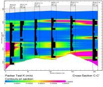
13 High Resolution Design Packer Multilevel System monitors m of bedrock 46 monitoring zones Monitoring Interval 3.6 zones per 10 m 32% sealed

14 Schematic Head Profile Sharp change in head (inflection) Monitoring Interval Packer Seal No to minimal change in head Meyer PhD, 2013

15 Schematic Vertical Gradient Profile Upward Gradient Unresolvable Vertical gradients Downward Gradient Meyer PhD, 2013

16 Head Profiles are Geometric Thin sections of large vertical gradient (inflections) Relatively low K v Thick sections of unresolvable vertical gradient Relatively high K v Meyer et al. 2008, Meyer PhD 2013

17 Head Profiles are Repeatable Dec 2003 Jun 2009 Aug 2011 Meyer et al. 2008, Meyer PhD 2013

18 Comparison to Lithostratigraphy Relatively low K v Relatively high K v Lithostratigraphy is not predictive of the position/thickness of K v contrasts Meyer et al. 2008, Meyer PhD 2013
19 Research Questions Do the vertical gradients correlate between locations What is the geologic basis for the shape of the head/vertical gradient profiles?


20 DNAPL Source Area ~ 72,000 L DNAPL Flow Plume ~ 2.8 km long in 2003

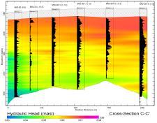
21 High Resolution MLS Transect
22 Key Points Vertical gradients occur at similar stratigraphic positions across the site (they correlate!) Indicate laterally extensive contrasts in K K contrasts are not coincident with lithostratigraphy
23 New Basis for Numerical Models Vertical Gradient Based Bedrock HGUs No HGU4
24 How Much Resolution is Enough? Lower resolution profiles do not accurately identify the position and thickness of K contrasts do not identify thin but important contrasts in K? provide inaccurate (blended) heads and gradients
25 Acknowledgements The research presented is a portion of Jessica Meyer s PhD dissertation. Dr. Beth Parker: Supervisor Dr. John Cherry: Collaborator and committee member Dr. Emmanuelle Arnaud: Collaborator and committee member Funding and In Kind Support Dr. Beth Parker s NSERC IRC and the University Consortium for Field Focused Groundwater Contamination Research Westbay Schlumberger Canada Ltd., Solinst, FLUTe, Stone Environmental, Golder
26 References Austin, D.C Hydrogeologic controls on contaminant distribution within a multi-component DNAPL zone in a sedimentary rock aquifer in south central Wisconsin. Master's thesis, University of Waterloo. Lima, G., B.L. Parker, and J.R. Meyer Dechlorinating microorganisms in a sedimentary rock matrix contaminated with a mixture of VOCs. Environmental Science & Technology 46, no.11: Meyer, J.R., B.L. Parker, and J.A. Cherry Detailed hydraulic head profiles as essential data for defining hydrogeologic units in layered fractured sedimentary rock. Environmental Geology 56, no.1: Meyer, J.R A high resolution vertical gradient approach to hydrogeologic unit delineation in fractured sedimentary rocks. PhD dissertation. University of Guelph. Parker, B.L., J.A. Cherry, and S.W. Chapman Discrete fracture network approach for studying contamination in fractured rock. AQUA mundi 3, no.2:
1. The Discrete Fracture Network (DFN) Approach for Contaminated Bedrock Site Characterization
 Approach for Contaminated Bedrock Site Characterization") 1. The Discrete Fracture Network (DFN) Approach for Contaminated Bedrock Site Characterization Beth L. Parker and John A. Cherry April 2011 Center for Applied Groundwater Research University of Guelph
1. The Discrete Fracture Network (DFN) Approach for Contaminated Bedrock Site Characterization Beth L. Parker and John A. Cherry April 2011 Center for Applied Groundwater Research University of Guelph
Finding Large Capacity Groundwater Supplies for Irrigation
 Finding Large Capacity Groundwater Supplies for Irrigation December 14, 2012 Presented by: Michael L. Chapman, Jr., PG Irrigation Well Site Evaluation Background Investigation Identify Hydrogeologic Conditions
A Short Course in Contaminated Fractured Rock Hydrogeology and Geophysics
 A Short Course in Contaminated Fractured Rock Hydrogeology and Geophysics An Eight Hour Geophysics Course Offered Through the Environmental Professionals' Organization of Connecticut Date: Nov 19, Nov
Impacts of DNAPL Contamination in Fractured Rock Aquifers Used for Municipal Water Supply
 Impacts of DNAPL Contamination in Fractured Rock Aquifers Used for Municipal Water Supply Beth Parker Professor & NSERC Chair University of Guelph, Ontario, Canada Round Table 2 September 16, 2009 Fractured
Aquitard Characterization The Legend of Indiana s Magic Clay Layer. Juliet Port, LPG #2214 July 2014
 Aquitard Characterization The Legend of Indiana s Magic Clay Layer Juliet Port, LPG #2214 July 2014 Topics What is an Aquitard? Why do we care? Review of Indiana glacial geology Conceptual Framework Investigation
The Potential for Compromised Interpretations When Based on Open Borehole Geophysical Data in Fractured Rock.
 The Potential for Compromised Interpretations When Based on Open Borehole Geophysical Data in Fractured Rock. Peeter Pehme *,1,2, Beth Parker 1,3, John A. Cherry 1, and John P. Greenhouse 2 It has long
Assessing the Tier 2 Trigger for Fractured Sedimentary Bedrock Sites
 Assessing the Tier 2 Trigger for Fractured Sedimentary Bedrock Sites Ken Lyon, Jennifer Arnold, Louise Burden Advisian WorleyParsons Group RemTech 2015, October 16, Banff, AB INTRODUCTION High level look
Contaminant Mass Distribution of a Mixed Organic Contaminant Plume Down-Gradient of an Aged DNAPL Source Zone in Sedimentary Rock
 Contaminant Mass Distribution of a Mixed Organic Contaminant Plume Down-Gradient of an Aged DNAPL Source Zone in Sedimentary Rock By Andrew Keith Buckley A Thesis presented to the University of Guelph
The use of straddle packer testing to hydraulically characterize rock boreholes for contaminant transport studies
 The use of straddle packer testing to hydraulically characterize rock boreholes for contaminant transport studies Patryk Quinn, John Cherry, Beth Parker Presentation for the Solinst Symposium November
Hydraulic and Water-Quality Characterization of Fractured-Rock Aquifers Using Borehole Geophysics
 Hydraulic and Water-Quality Characterization of Fractured-Rock Aquifers Using Borehole Geophysics John H. Williams Office of Ground Water Troy, New York Flow in Open Borehole Runkel and others (2003) Ambient
Regional groundwater mapping and model
 Regional groundwater mapping and model Boyd, Dwight 1, Steve Holysh 2, and Jeff Pitcher 1 1 Grand River Conservation Authority, Canada; 2 Regional Municipality of Halton, Canada The Grand River forms one
Basin Analysis Applied to Modelling Buried Valleys in the Great Lakes Basin
 EARTH SCIENCES SECTOR GENERAL INFORMATION PRODUCT 35 Basin Analysis Applied to Modelling Buried Valleys in the Great Lakes Basin Sharpe, D R; Russell, H A J 2004 Originally released as: Basin Analysis
Pressure Grouting of Fractured Bedrock to Control Acid Mine Drainage
 WATER RESOURCES AT RISK May 14-18, 1995 Denver American Institute of Hydrology Pressure Grouting of Fractured Bedrock to Control Acid Mine Drainage S. A. Effner, G. D. Vandersluis, and V. Straskraba Hydro-Geo
David de Courcy-Bower and Samuel Mohr
 Applicability and Limitations of LNAPL Transmissivity as a Metric within Bedrock Formations Insert then choose Picture select your picture. Right click your picture and Send to back. David de Courcy-Bower
Groundwater Modeling for Flow Systems with Complex Geological and Hydrogeological Conditions
 Available online at www.sciencedirect.com Procedia Earth and Planetary Science 3 ( 2011 ) 23 28 2011 Xi an International Conference on Fine Geological Exploration and Groundwater & Gas Hazards Control
Buried-valley Aquifers: Delineation and Characterization from Reflection Seismic and Core Data at Caledon East, Ontario
 Buried-valley Aquifers: Delineation and Characterization from Reflection Seismic and Core Data at Caledon East, Ontario Russell, H.A.J. 1, S.E. Pullan 1, J.A. Hunter 1, D.R. Sharpe 1, and S. Holysh 2 1
FRACTURED ROCK Characterization and Remediation. Allan Horneman September 30, 2016
 FRACTURED ROCK Characterization and Remediation Allan Horneman September 30, 2016 Disclaimers and Notices The materials herein are intended to furnish viewers with a summary and overview of general information
Presented by: Peter J. Foster. Coauthors: James M. Emery Kenneth C. Hardcastle. Emery & Garrett Groundwater Investigations, LLC
 The Impacts of the Earthquake that Struck near Mineral Virginia on Groundwater Resources in Northern Virginia Presented by: Peter J. Foster Coauthors: James M. Emery Kenneth C. Hardcastle Introduction
Evaluation of an Oxygen Injection Technology for In-Situ Hydrocarbon Bioremediation in a Fractured Bedrock Environment
 Evaluation of an Oxygen Injection Technology for In-Situ Hydrocarbon Bioremediation in a Fractured Bedrock Environment Karen D. Greer 1,2 1 WESA Inc. Kitchener, Ontario, Canada J. Barker 2, J. Molson 2,3,
DNAPL migration through interbedded clay-sand sequences
 Groundwater Quality: Natural and Enhanced Restoration of Groundwater Pollution (Proceedings ofthe Groundwater Quality 2001 Conference held al Sheffield. UK. June 2001). IAHS Publ. no. 275. 2002. 455 DNAPL
Initial Borehole Drilling and Testing in or Near Ignace
 JUNE 2016 PRELIMINARY ASSESSMENT OF POTENTIAL SUITABILITY Initial Borehole Drilling and Testing in or Near Ignace DRAFT FOR DISCUSSION WITH COMMUNITIES In 2010, the Nuclear Waste Management Organization
Use of Tracer Dyes to Understand Fractured Bedrock Flow during a Pumping Test
 Use of Tracer Dyes to Understand Fractured Bedrock Flow during a Pumping Test 2015 NGWA Conference on Groundwater in Fractured Rock Presenter: Bette Nowack, PE, Stone Environmental Co-Authors: Andrew Fuller,
The Geology and Hydrogeology of the Spyhill Area
 The Geology and Hydrogeology of the Spyhill Area Clare North (WorleyParsons Komex) and Martin Ortiz (The City of Calgary) 2-Jul-08 Outline Background Site Location Existing Information New Work Geology
Appendix D Fractured Rock Appendix
 Appendix D Fractured Rock Appendix 1.0 Introduction The behavior of LNAPL in fractured bedrock is not necessarily intuitive and is not as easily described using the principles and techniques adopted for
Azimuthal Resistivity to Characterize Fractures in a Glacial Till. Mark Boris, University of Saskatchewan Jim Merriam, University of Saskatchewan
 Azimuthal Resistivity to Characterize Fractures in a Glacial Till Mark Boris, University of Saskatchewan Jim Merriam, University of Saskatchewan Abstract Azimuthal resistivity was used to characterize
Initial Borehole Drilling in the Hornepayne and Manitouwadge Area
 MAY 2017 PRELIMINARY ASSESSMENT OF POTENTIAL SUITABILITY Initial Borehole Drilling in the Hornepayne and Manitouwadge Area In 2010, the Nuclear Waste Management Organization (NWMO) began technical and
SASKATCHEWAN STRATIGRAPHY GLACIAL EXAMPLE BOULDERS IN GLACIAL DEPOSITS
 SASKATCHEWAN STRATIGRAPHY GLACIAL EXAMPLE BOULDERS IN GLACIAL DEPOSITS 51 SASKATCHEWAN STRATIGRAPHY GLACIAL SURFICIAL STRATIFIED DEPOSITS 52 SASKATCHEWAN STRATIGRAPHY GLACIAL EXAMPLE OF SEDIMENT DEPOSITION
Control of Fractured Bedrock Structure on the Movement of Chlorinated Volatile Organics in Bedrock and Overburden Aquifers, Newark Basin of New Jersey
 Control of Fractured Bedrock Structure on the Movement of Chlorinated Volatile Organics in Bedrock and Overburden Aquifers, Newark Basin of New Jersey Robert M. Bond, PG and Katherine E. Linnell, PG, Langan
ENVIRONMENTAL EFFECTS OF GROUNDWATER WITHDRAWAL IN SOUTH NYÍRSÉG
 PhD thesis ENVIRONMENTAL EFFECTS OF GROUNDWATER WITHDRAWAL IN SOUTH NYÍRSÉG János Szanyi Szeged, 2004 ENVIRONMENTAL EFFECTS OF GROUNDWATER WITHDRAWAL IN SOUTH NYÍRSÉG Preliminaries, the aims of the dissertation
Determining In Situ Properties of Claystone Aquitards Using Pore Pressure Responses from Grouted-in Pressure Transducers
 Determining In Situ Properties of Claystone Aquitards Using Pore Pressure Responses from Grouted-in Pressure Transducers Laura A. Smith, S. Lee Barbour, M. Jim Hendry University of Saskatchewan, Saskatoon,
Harvey Thorleifson, Director, Minnesota Geological Survey. Status of geological mapping needed for groundwater protection in Minnesota
 Harvey Thorleifson, Director, Minnesota Geological Survey Status of geological mapping needed for groundwater protection in Minnesota Minnesota is located between the Dakotas and Wisconsin, north of Iowa,
HOW. HOW vehicle mounted units portable units also available. HOW, WHEN & WHY to Geophysically Log in S.I.?
 HOW, WHEN & WHY to Geophysically Log in S.I.? by Kim Beesley HOW HOW vehicle mounted units portable units also available Access to borehole Depth of borehole sump / rat -hole? 1 HOW? - subject to borehole
DATA ACQUISITION METHODS FOR GROUNDWATER INVESTIGATION AND THE SITING OF WATER SUPPLY WELLS
 DATA ACQUISITION METHODS FOR GROUNDWATER INVESTIGATION AND THE SITING OF WATER SUPPLY WELLS M.B.J. Foster Tetra Tech EM Inc., San Francisco, CA, USA Keywords: Groundwater, water wells, drilled wells, geophysical
A Risk-based Groundwater Modelling Study for Predicting Thermal Plume Migration from SAGD Well-pads
 A Risk-based Groundwater Modelling Study for Predicting Thermal Plume Migration from SAGD Well-pads Rudy Maji, Ph.D., Golder Associates Solaleh Khezri, M.Sc., AB Scientific Intern (Golder Associates) Don
Initial Borehole Drilling and Testing in Central Huron,
 JULY 2016 PRELIMINARY ASSESSMENT OF POTENTIAL SUITABILITY Initial Borehole Drilling and Testing in Central Huron, Huron-Kinloss and South Bruce DRAFT FOR DISCUSSION WITH COMMUNITIES In 2012, at the request
February 22, 2011 Picatinny Team Meeting Edison, New Jersey
 February 22, 2011 Picatinny Team Meeting Edison, New Jersey Updated Groundwater Model and Remedies Mid-Valley Groundwater (PICA 204) February 22, 2011 Imagine the result Review of 2009 2010 Field Program
Case Study: University of Connecticut (UConn) Landfill
 Landfill") Case Study: University of Connecticut (UConn) Landfill Problem Statement:» Locate disposal trenches» Identify geologic features and distinguish them from leachate and locate preferential pathways in fractured
Case Study: University of Connecticut (UConn) Landfill Problem Statement:» Locate disposal trenches» Identify geologic features and distinguish them from leachate and locate preferential pathways in fractured
Rock Mechanics for Tunneling
 Rock Mechanics for Tunneling Discrete Fracture Approach Dr. William Dershowitz Dept of Civil Engineering University of Washington FracMan Technology Group Golder Associates Inc Rock Quality -RQD Rock Quality
ambiguity in earth sciences IESO Geophysics Section Eddy hartantyo, Lab Geofisika FMIPA UGM
 ambiguity in earth sciences IESO Geophysics Section Eddy hartantyo, Lab Geofisika FMIPA UGM Pelatihan Tahap II IESO Teknik Geologi UGM Februari 2009 1 Introduction Photos from http://www.eegs.org/whatis/
How Can We Sustain Groundwater Quality in Karst and Fracturedcarbonate. Maureen A. Muldoon Geology Department Univ. Of Wisconsin-Oshkosh
 How Can We Sustain Groundwater Quality in Karst and Fracturedcarbonate Aquifers? Maureen A. Muldoon Geology Department Univ. Of Wisconsin-Oshkosh The Question Karst and fracturedcarbonates form productive,
HYDROGEOLOGICAL PROPERTIES OF THE UG2 PYROXENITE AQUIFERS OF THE BUSHVELD COMPLEX
 R. Gebrekristos, P.Cheshire HYDROGEOLOGICAL PROPERTIES OF THE UG2 PYROXENITE AQUIFERS OF THE BUSHVELD COMPLEX R. Gebrekristos Digby Wells Environmental P. Cheshire Groundwater Monitoring Services Abstract
Geological Mapping using Geophysics
 Geological Mapping using Geophysics Pugin, A.J.M. and T.H. Larson Illinois State Geological Survey, 615 E Peabody Dr., Champaign, IL 61820; E-mail: A.J.M. Pugin at pugin@isgs.uiuc.edu Mapping Techniques.
Towards Seamless Interactions Between Geologic Models and Hydrogeologic Applications
 Towards Seamless Interactions Between Geologic Models and Hydrogeologic Applications Ross, M. 1, M. Parent 2, R. Martel 1, and R. Lefebvre 1 1 Institut National de la Recherche Scientifique (INRS-ETE),
DRAFT SITE CONCEPTUAL MODEL FOR THE MIGRATION AND FATE OF CONTAMINANTS IN GROUNDWATER AT THE SANTA SUSANA FIELD LABORATORY, SIMI, CALIFORNIA
 DRAFT SITE CONCEPTUAL MODEL FOR THE MIGRATION AND FATE OF CONTAMINANTS IN GROUNDWATER AT THE SANTA SUSANA FIELD LABORATORY, SIMI, CALIFORNIA OVERVIEW AND 20 SITE CONCEPTUAL MODEL ELEMENTS VOLUME 1 OF 4
CHARACTERIZATION OF A FRACTURED AQUIFER USING THE COLLOIDAL BORESCOPE
 CHARACTERIZATION OF A FRACTURED AQUIFER USING THE COLLOIDAL BORESCOPE PETER M. KEARL 1,, KIRK ROEMER 2, *, ERIC B. ROGOFF 3 AND RICHARD M. RENN 3 1 AquaVISION 375 33½ Road, Palisade, CO 81526 2 Life Sciences
Formation Stratigraphy and Interfingering at the Port of Miami
 Formation Stratigraphy and Interfingering at the Port of Miami AUGUST 6, 2012 PROJECT PARTNERS Public Sponsors 90% Equity Partner Contractor 10% Equity Partner VMS Operator Federal Support FUNDING PARTNERS
Effects of depositional and diagenetic heterogeneitites on fluid flow in Plio -- Pleistocene reefal carbonates of the Southern Dominican Republic
 Viviana Díaz was born in Puerto Rico and received her undergraduate degree from the University of Puerto Rico and her Master's at the University of North Carolina. She is currently working on her PhD at
Determination of Geothermal Gradient in the Eastern Niger Delta Sedimentary Basin from Bottom Hole Temperatures
 Journal of Earth Sciences and Geotechnical Engineering, vol. 4, no. 3, 2014, 109-114 ISSN: 1792-9040 (print), 1792-9660 (online) Scienpress Ltd, 2014 Determination of Geothermal Gradient in the Eastern
10. GEOTECHNICAL EXPLORATION PROGRAM
 Geotechnical site investigations should be conducted in multiple phases to obtain data for use during the planning and design of the tunnel system. Geotechnical investigations typically are performed in
BOS 100 Overburden and Bedrock Groundwater Remediation Former Dry Cleaning Facility
 BOS 100 Overburden and Bedrock Groundwater Remediation Former Dry Cleaning Facility Site Description Location Central Kentucky Site Use Retail Shopping Center Geologic Setting Inner Bluegrass Bedrock Ordovician
Impact of the Danube River on the groundwater dynamics in the Kozloduy Lowland
 GEOLOGICA BALCANICA, 46 (2), Sofia, Nov. 2017, pp. 33 39. Impact of the Danube River on the groundwater dynamics in the Kozloduy Lowland Peter Gerginov Geological Institute, Bulgarian Academy of Sciences,
NEW PRODUCTS AND ADVANCEMENTS IN 3-D MODELLING PROTOCOLS BASED ON STUDIES IN THICK DRIFT AREAS IN ONTARIO, CANADA
 NEW PRODUCTS AND ADVANCEMENTS IN 3-D MODELLING PROTOCOLS BASED ON STUDIES IN THICK DRIFT AREAS IN ONTARIO, CANADA Abigail K. Burt and Andrew F. Bajc Ontario Geological Survey, 933 Ramsey Lake Road, Sudbury,
RESISTIVITY IMAGING AND BOREHOLE INVESTIGATION OF THE BANTING AREA AQUIFER, SELANGOR, MALAYSIA. A.N. Ibrahim Z.Z.T. Harith M.N.M.
 JOURNAL OF ENVIRONMENTAL HYDROLOGY The Electronic Journal of the International Association for Environmental Hydrology On the World Wide Web at http://www.hydroweb.com VOLUME 11 2003 RESISTIVITY IMAGING
iii CONTENTS vii ACKNOWLEDGMENTS EXECUTIVE SUMMARY INTRODUCTION Study Area Data Sources Preparation of Geologic Maps
 CONTENTS ACKNOWLEDGMENTS EXECUTIVE SUMMARY INTRODUCTION Study Area Data Sources Preparation of Geologic Maps GEOLOGY Bedrock Geology Succession and Distribution Structural Features Description of Bedrock
Site Characterization & Hydrogeophysics
 Site Characterization & Hydrogeophysics (Source: Matthew Becker, California State University) Site Characterization Definition: quantitative description of the hydraulic, geologic, and chemical properties
Soils, Hydrogeology, and Aquifer Properties. Philip B. Bedient 2006 Rice University
 Soils, Hydrogeology, and Aquifer Properties Philip B. Bedient 2006 Rice University Charbeneau, 2000. Basin Hydrologic Cycle Global Water Supply Distribution 3% of earth s water is fresh - 97% oceans 1%
HYBRID DETERMINISTIC AND STOCHASTIC HYDROSTRATIGRAPHIC MODELING OF A COMPLEX GLACIAL AQUIFER SYSTEM
 HYBRID DETERMINISTIC AND STOCHASTIC HYDROSTRATIGRAPHIC MODELING OF A COMPLEX GLACIAL AQUIFER SYSTEM Lawrence D. Lemke, Andrew L. Frahm, Lena K. Pappas Department of Geology, Wayne State University, Detroit,
11/22/2010. Groundwater in Unconsolidated Deposits. Alluvial (fluvial) deposits. - consist of gravel, sand, silt and clay
 deposits. - consist of gravel, sand, silt and clay") Groundwater in Unconsolidated Deposits Alluvial (fluvial) deposits - consist of gravel, sand, silt and clay - laid down by physical processes in rivers and flood plains - major sources for water supplies
Groundwater in Unconsolidated Deposits Alluvial (fluvial) deposits - consist of gravel, sand, silt and clay - laid down by physical processes in rivers and flood plains - major sources for water supplies
Geophysical Surveys for Groundwater Modelling of Coastal Golf Courses
 1 Geophysical Surveys for Groundwater Modelling of Coastal Golf Courses C. RICHARD BATES and RUTH ROBINSON Sedimentary Systems Research Group, University of St. Andrews, St. Andrews, Scotland Abstract
Groundwater Hydrology
 EXERCISE 12 Groundwater Hydrology INTRODUCTION Groundwater is an important component of the hydrologic cycle. It feeds lakes, rivers, wetlands, and reservoirs; it supplies water for domestic, municipal,
Aquifer Mapping and Characterization in southern Ontario:
 OGS-GSC Open House, Guelph March10 th, 2016 Aquifer Mapping and Characterization in southern Ontario: A Collaborative OGS GSC project 2014-2019 Hazen A.J. Russell & Andy F. Bajc Where to Find us! Workshop
Lower Mainland Surficial Geology From Wisconsin Ice Age to Protocol 21
 Lower Mainland Surficial Geology From Wisconsin Ice Age to Protocol 21 BCEIA BEST Conference 2018 Whistler, BC Kalina Malowany and Virginie Brunetaud Presentation Outline 1. Surficial Geology it s more
BERG-HUGHES CENTER FOR PETROLEUM AND SEDIMENTARY SYSTEMS. Department of Geology and Geophysics College of Geosciences
 BERG-HUGHES CENTER FOR PETROLEUM AND SEDIMENTARY SYSTEMS Department of Geology and Geophysics College of Geosciences MISSION Integrate geoscience, engineering and other disciplines to collaborate with
2 OVERVIEW OF SHALLOW BOREHOLE INVESTIGATIONS
 2 OVERVIEW OF SHALLOW BOREHOLE INVESTIGATIONS Preparation for MSB-2 started in April 2002. Drilling and planned field work in both MSB-2 and 4 were carried out at the same time. After completion of the
HYDROGEOLOGIC FRAMEWORK OF LONG ISLAND'S NORTH FORK, SUFFOLK COUNTY, NEW YORK
 HYDROGEOLOGIC FRAMEWORK OF LONG ISLAND'S NORTH FORK, SUFFOLK COUNTY, NEW YORK Christopher E. Schubert 1, Richard E. Bova 2, and Paul E. Misut 1 1 U.S. Geological Survey, 2045 Route 112, Building 4, Coram,
Evaluation of Subsurface Formation of Pabna District, Bangladesh
 IOSR Journal of Applied Geology and Geophysics (IOSR-JAGG) e-issn: 2321 0990, p-issn: 2321 0982.Volume 1, Issue 4 (Sep. Oct. 2013), PP 30-36 Evaluation of Subsurface Formation of Pabna District, Bangladesh
Delineation of Zones at Risk from Groundwater Inflows at an Underground Platinum Mine in South Africa
 Delineation of Zones at Risk from Groundwater Inflows at an Underground Platinum Mine in South Africa Mr Andreas Stoll andreas.stoll@erm.com Environmental Resources Management Swiss GmbH (ERM), Switzerland
Dewatering of a Deep Shaft in a Complex Hydrogeologic Setting
 Dewatering of a Deep Shaft in a Complex Hydrogeologic Setting Michael Gabora 1, Phillip Brown 2, Hank Ohlin 3, Korin Carpenter 3 and Greg French 3 1. Ausenco, USA 2. Independent Consultant, USA 3. Nevada
The mountain is permeable and fractured: Hydrological Connectivity in the Laramie Range
 WyCHEG Interest Group Meeting, Oct 30, 2017, Laramie, WY The mountain is permeable and fractured: Hydrological Connectivity in the Laramie Range Ye Zhang 1, Brad Carr 1, Shuangpo Ren 2, Andy Parsekian
Chapter 8 Fetter, Applied Hydrology 4 th Edition, Geology of Groundwater Occurrence
 Chapter 8 Fetter, Applied Hydrology 4 th Edition, 2001 Geology of Groundwater Occurrence Figure 8.42. Alluvial Valleys ground-water region. Fetter, Applied Hydrology 4 th Edition, 2001 Fetter, Applied
Appendix Z. Groundwater Assessment Supplementary Report. Document Name i Insert Month/Year
 Appendix Z Groundwater Assessment Supplementary Report Document Name i Insert Month/Year Australasian Groundwater and Environmental Consultants Pty Ltd Level 2 / 15 Mallon Street Bowen Hills, QLD 4006
Understanding Subsurface Fate & Transport
 Back-to-Basics Part 1: Developing the CSM & Site Characterization Understanding Subsurface Fate & Transport Understanding Subsurface Fate & Transport Purpose: To provide an introduction to the basics of
Seismic Reflection Imaging across the Johnson Ranch, Valley County, Idaho
 Seismic Reflection Imaging across the Johnson Ranch, Valley County, Idaho Report Prepared for the Skyline Corporation Lee M. Liberty Center for Geophysical Investigation of the Shallow Subsurface (CGISS)
An Hypothesis Concerning a Confined Groundwater Zone in Slopes of Weathered Igneous Rocks
 Symposium on Slope Hazards and Their Prevention: 8-10 May, 2000, Hong Kong, PRC An Hypothesis Concerning a Confined Groundwater Zone in Slopes of Weathered Igneous Rocks J. J. Jiao and A. W. Malone Department
Graduate Student Researcher: Leslie Randolph, Geology Department, Texas A&M University, College Station, TX. (979)
") Spatial and Temporal Characterization of the Radon Distribution in a Region of the Hickory Aquifer in Central Texas: Assessment of Stratigraphy and Groundwater Dynamics on Radon Concentrations Project
Spatial and Temporal Characterization of the Radon Distribution in a Region of the Hickory Aquifer in Central Texas: Assessment of Stratigraphy and Groundwater Dynamics on Radon Concentrations Project
Geophysical Exploration in Water Resources Assessment. John Mundell, P.E., L.P.G., P.G. Ryan Brumbaugh, L.P.G. Mundell & Associates, Inc.
 Geophysical Exploration in Water Resources Assessment John Mundell, P.E., L.P.G., P.G. Ryan Brumbaugh, L.P.G. Mundell & Associates, Inc. Presentation Objective Introduce the use of geophysical survey methods
Phase 1 Geoscientific Preliminary Assessment Southern Ontario, Sedimentary Communities
 Phase 1 Geoscientific Preliminary Assessment Southern Ontario, Sedimentary Communities Presented to: Community Liaison Committees (Brockton, Huron-Kinloss, South Bruce) March 2014 Project Description»
Deep Weathering at the LCZO
 Deep Weathering at the LCZO Heather L. Buss USGS Water Energy and Biogeochemical Budgets Program (WEBB), Puerto Rico Qtz Chlorite Hornblende Plag Plag Projects Observation wells: The Drilling Project :
Deep Borehole Disposal Performance Assessment and Criteria for Site Selection
 Deep Borehole Disposal Performance Assessment and Criteria for Site Selection Sandia is a multiprogram laboratory operated by Sandia Corporation, a Lockheed Martin Company, for the United States Department
Evaluation of the hydraulic gradient at an island for low-level nuclear waste disposal
 A New Focus on Groundwater Seawater Interactions (Proceedings of Symposium HS1001 at IUGG2007, Perugia, July 2007). IAHS Publ. 312, 2007. 237 Evaluation of the hydraulic gradient at an island for low-level
Parameters for groundwater modelling
 Parameters for groundwater modelling, Arto Pullinen and Antti Pasanen Seminar on management of water balance in mining areas, 28.8.2015, SYKE 28.08.2015 1 Introduction WaterSmart Project GTK s main task
Risks of environmental contamination from proposed fracking in the Fylde, Lancashire
 Risks of environmental contamination from proposed fracking in the Fylde, Lancashire A short slideshow Professor David Smythe November 2014 1 Introduction Shale is a very common kind of rock, found in
Buried Bedrock Channels in the Athabasca Oil Sands Region Conceptual Understanding and Implications to Water Supply
 Buried Bedrock Channels in the Athabasca Oil Sands Region Conceptual Understanding and Implications to Water Supply Scott Rayner Matrix Solutions Inc. Sandra Rosenthal Devon Canada Corporation Presentation
Investigation of the Impact of Fracture Intersection on Solute Transport in Fractured Carbonate. Abstract. 2. Site description
 Investigation of the Impact of Fracture Intersection on Solute Transport in Fractured Carbonate Catherine Ledoux, Département de géologie et génie géologique, Université Laval, Québec, Canada René Therrien,
Remedial Program. GE Hudson Falls Plant Site. GE Hudson Falls Plant Site. TDCS Status
 Updates on Remedial Programs at the GE Hudson Falls Plant Site and GE Fort Edward Plant Site GE Hudson Falls USEPA Community Advisory Group Meeting September 11, 2008 GE Fort Edward Division of Environmental
RESISTIVITY IMAGING IN EASTERN NEVADA USING THE AUDIOMAGNETOTELLURIC METHOD FOR HYDROGEOLOGIC FRAMEWORK STUDIES. Abstract.
 RESISTIVITY IMAGING IN EASTERN NEVADA USING THE AUDIOMAGNETOTELLURIC METHOD FOR HYDROGEOLOGIC FRAMEWORK STUDIES Darcy K. McPhee, U.S. Geological Survey, Menlo Park, CA Louise Pellerin, Green Engineering,
GPR AS A COST EFFECTIVE BEDROCK MAPPING TOOL FOR LARGE AREAS. Abstract
 GPR AS A COST EFFECTIVE BEDROCK MAPPING TOOL FOR LARGE AREAS Dr. Jutta L. Hager, Hager GeoScience, Inc., Waltham, MA Mario Carnevale, Hager GeoScience, Inc., Waltham, MA Abstract Hager GeoScience, Inc.
FLOOD1 report: Appendix 3
 FLOOD1 report: Appendix 3 Summary of Laboratory Testing Programme Part of the investigation into the behaviour of groundwater in the unsaturated zone of the Chalk required testing samples to determine
Table 5-1 Sampling Program Summary for Milltown Ford Avenue Redevelopment Area, NJ.
 Table 5- Sampling Program Summary for Milltown Ford Avenue Redevelopment Area, NJ. Transformer Pads (9 pads: PAD 9) Evaluate if PCBs presently exist in soils adjacent to, and/or beneath the transformer
DESIGN-PHASE GEOLOGIC FRAMEWORK MODELING FOR LARGE CONSTRUCTION PROJECTS
 DESIGN-PHASE GEOLOGIC FRAMEWORK MODELING FOR LARGE CONSTRUCTION PROJECTS Christine Vilardi, P.G., C.G.W.P. (vilardcl@stvinc.com, STV Inc., New York, New York) and Todd Kincaid, Ph.D. (Hazlett-Kincaid,
Hydrologic and Borehole Geophysical Investigation of Bedrock Observation Wells at the University of Maine
 Hydrologic and Borehole Geophysical Investigation of Bedrock Observation Wells at the University of Maine Abstract Eric Rickert, Andrew Reeve, Frederick L. Paillet, University of Maine The University of
Data Report for White Point Landslide Boring B-12 W.O. E Task Order Solicitation San Pedro District Los Angeles, California
 Data Report for White Point Landslide Boring B-12 W.O. E1907483 Task Order Solicitation 11-087 San Pedro District Los Angeles, California Submitted To: Mr. Christopher F. Johnson, P.E., G.E. City of Los
Back-to-Basics Part 1: Developing the CSM & Site Characterization
 Back-to-Basics Part 1: Developing the CSM & Site Characterization Agenda What is a CSM and how do you use it Physical Components (Geology, Hydrogeology, and Chemistry) Site Use History Likely Fate and
Hydrogeology of Karst NE Wisconsin. Dr. Maureen A. Muldoon UW-Oshkosh Geology Department
 Hydrogeology of Karst NE Wisconsin Dr. Maureen A. Muldoon UW-Oshkosh Geology Department WI Bedrock Outline Karst Landscapes Existing WQ Data Flow in Karst Aquifers Overview of Silurian Aquifer Water Level
Developments in Storage and Monitoring for CCUS
 Developments in Storage and Monitoring for CCUS Steve Whittaker Director Energy Research & Development Illinois State Geological Survey 4 th Beijing International Forum on Carbon Capture, Utilization and
WESTCARB Phase I Results Review
 WESTCARB Phase I Results Review Arizona Geologic Characterization Errol Montgomery Principal Errol L. Montgomery & Associates (520) 881-4912 emontgomery@elmontgomery.com November 9, 2005 Site Characterization
HYDRAULIC CONDUCTIVITY AND SPECIFIC STORAGE OF THE MAQUOKETA SHALE
 HYDRAULIC CONDUCTIVITY AND SPECIFIC STORAGE OF THE MAQUOKETA SHALE A Final Report prepared for the UNIVERSITY OF WISCONSIN WATER RESOURCES INSTITUTE Prepared by Timothy T. Eaton 1,2 David J. Hart 2 Kenneth
Robert John Stuetzle. A Thesis presented to The University of Guelph
 Vertical Profiling Data Sets for Improved Characterization of Hydrologic Units Influencing Contaminant Migration in Strongly Heterogeneous Triassic Sediments By Robert John Stuetzle A Thesis presented
Geologic Mapping in Northeastern Illinois. What do we know about. Donald A. Keefer, Director Geologic Mapping and Hydrogeology Center
 Geologic Mapping in Northeastern Illinois & What do we know about Lake County s Geology? Donald A. Keefer, Director Geologic Mapping and Hydrogeology Center Societal Benefits of Mapping Water Supply Delineation,
Oak Ridges Moraine Aquifer Vulnerability Mapping
 Accompanying Document to the Reference Map for Ontario Regulation 140/02 (Oak Ridges Moraine Conservation Plan) March 2004 2 1. Purpose of Report Accompanying Document to the Reference Map for Ontario