Buried Bedrock Channels in the Athabasca Oil Sands Region Conceptual Understanding and Implications to Water Supply
|
|
|
- Chad Mills
- 5 years ago
- Views:
Transcription


1 Buried Bedrock Channels in the Athabasca Oil Sands Region Conceptual Understanding and Implications to Water Supply Scott Rayner Matrix Solutions Inc. Sandra Rosenthal Devon Canada Corporation
2 Presentation Outline Study area Regional and local geology Hydrogeology hydraulic head mapping groundwater chemistry Implications to water supply Summary/Conclusions


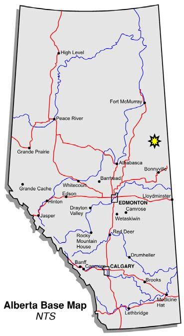
3 Fort McMurray Study Area and Surface Topography St o ny M ou nt ai n Up la nd s Athabasca River Clearwater River Ma yh ills Mostoos Hills Uplands
4 Regional and Local Geology

5 Hydrostratigraphy Top of Bedrock CHANNEL SAND AQUIFER

6 Bedrock Topography (Andriashek, 2003) Fort McMurray Gregoire Channel Clearwater River Channel width can range from less than 500 m to greater than 30 km Channel length can range from less than 10 km to greater than 200 km Can incise into Cretaceous bedrock greater than 150 m Athabasca River Christina Channel Kirby Channel Wiau Channel Andriashek, L.D Quaternary Geological Setting of the Athabasca Oil Sands (In Situ) Area, Northeast Alberta EUB/AGS Earth Sciences Report


7 Local Bedrock Topography Christina Channel Kirby Channel Sunday Creek Channel


8 South to North Structural Cross Section A-A A A Wiau Channel Sunday Creek Channel Christina Channel La Biche Joli Fou Joli Fou Channel Sand Aquifer Grand Rapids C McMurray


9 Subcropping Cretaceous Formations An Integrated Interpretation Christina Channel Kirby Channel 3D Seismic Area Sunday Creek Channel 2D Seismic Line


10 Sunday Creek Channel Cross Section A 930 m A AA/ W4 AB/ W4 AA/ W4 900 m Sunday Creek Channel La Biche Sunday Creek Channel Viking Joli Fou Grand Rapids A Grand Rapids B 150 m Viking Joli Fou Grand Rapids A Grand Rapids B Grand Rapids C Channel Sand Aquifer Grand Rapids C Clearwater Shale 350 mbgs Clearwater Shale Clearwater A
11 Hydrogeology

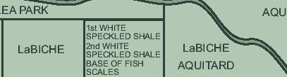
12 South-North Regional Schematic Hydrostratigraphic Cross Section Aquifer Aquifer/Aquitard Aquitard Local Study Area Undifferentiated Overburden Channel Sand Aquifer La Biche Aquitard La Biche Aquitard Joli Fou Aquitard Upper Grand Rapids Aquifer Lower Grand Rapids Aquifer Clearwater B AquiferClearwater A Aquifer Undifferentiated McMurray Basal McMurray Aquifer Beaverhill Lake Group


13 Channel Sand Aquifer Extent Fort McMurray Clearwater River Athabasca River Leismer Channel Gregoire Channel Christina Channel Wiau Channel Kirby Channel Sunday Creek Channel

14 Groundwater Flow Fort McMurray Clearwater River Channel Sand Aquifer Athabasca River Christina Channel Wiau Channel Sunday Creek Channel CHANNEL SAND AQUIFER

15 Athabasca River Groundwater Flow Grand Rapids Formation Fort McMurray Clearwater River Stony Mountain Uplands


16 West to East Structural Cross Section With Interpreted Hydraulic Head Contours Kirby Channel Sunday Creek Channel La Biche Joli Fou Channel Sand Aquifer La Biche Joli Fou Channel Sand Aquifer La Biche Joli Fou Grand Rapids C McMurray


17 Total Dissolved Solids Concentration versus Depth Increase in TDS with depth from less than 1,000 mg/l to greater than 18,000 mg/l Non-Saline Saline

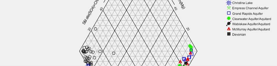
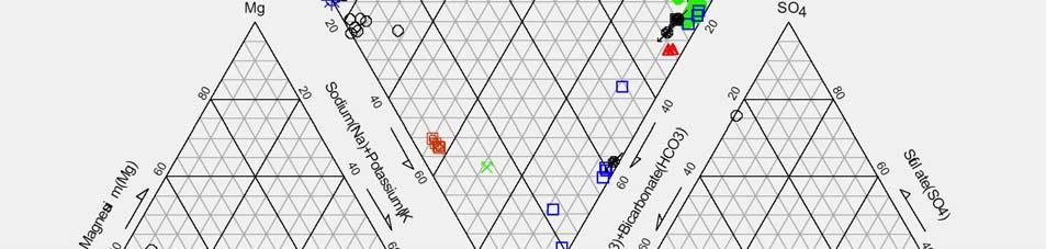

18 Change in Groundwater Chemistry with Depth (Surface Water) Change in water type from calcium-bicarbonate to sodium-chloride

19 Lower Grand Rapids Aquifer Average Resistivity (R t ) and TDS Distribution Christina Channel Kirby Channel Sunday Creek Channel
20 Implications to Water Supply
21 Implications to Water Supply Source well deliverability is increased as a result of the groundwater mounding (higher available head) in the Grand Rapids Source wells have been located away from the deepest channel incisions to ensure saline groundwater is withdrawn In accordance with the Alberta Environment Water Conservation and Allocation Guideline for Oilfield Injection Sodium chloride water (TDS 4,000 to 10,000 mg/l) is easier to treat (for steam generation) As operations continue, pressure and groundwater chemistry will be monitored


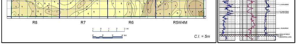
22 Lower Grand Rapids Aquifer Isopach Incision into Lower Grand Rapids Aquifer Observation Wells Source Wells Up to 44 m thick
23 Summary/Conclusions An integrated approach is required when solving water supply challenges The depth of incision and subcropping Cretaceous formations strongly influences: hydraulic head distribution within the channels and Cretaceous formations groundwater chemistry of Cretaceous formations The presence of buried bedrock channels have important implications to water supply in terms of deliverability and source water chemistry
Buried Bedrock Channels in the Athabasca Oil Sands Region Conceptual Understanding and Implications to Water Supply
 Buried Bedrock Channels in the Athabasca Oil Sands Region Conceptual Understanding and Implications to Water Supply Scott Rayner 1 and Sandra Rosenthal 2 1 Matrix Solutions Inc. 118, 319 2nd Ave. SW, Calgary
A Risk-based Groundwater Modelling Study for Predicting Thermal Plume Migration from SAGD Well-pads
 A Risk-based Groundwater Modelling Study for Predicting Thermal Plume Migration from SAGD Well-pads Rudy Maji, Ph.D., Golder Associates Solaleh Khezri, M.Sc., AB Scientific Intern (Golder Associates) Don
Geologic Considerations of Shallow SAGD Caprock; Seal Capacity, Seal Geometry and Seal Integrity, Athabasca Oilsands, Alberta Canada
 Geologic Considerations of Shallow SAGD Caprock; Seal Capacity, Seal Geometry and Seal Integrity, Athabasca Oilsands, Alberta Canada Gordon T. Stabb, Michael Webb Durando Resources Corp, Suncor Energy
Origin and Evolution of Formation Waters in the West-Central Part of the Alberta Basin
 Page No. 004-1 Origin and Evolution of Formation Waters in the West-Central Part of the Alberta Basin Karsten Michael* University of Alberta, 1-26 ESB, Edmonton, AB T6G 2E3 karsten@ualberta.ca and Stefan
https://gsa.confex.com/gsa/2014am/webprogram/paper html
 Abstract: IMPACT OF PALEOZOIC KARST UPON GROUNDWATER FLOW IN TH... https://gsa.confex.com/gsa/2014am/webprogram/paper244571.html Page 1 of 1 28/08/2014 Start Author Index Meeting Information Paper No.
Hydrochemical Assessment of The Devonian Keg River Formation
 Hydrochemical Assessment of The Devonian Keg River Formation Francisco Castrillon-Munoz, MSc., P.Geol. Senior Hydrogeologist Worley Parsons Canada Thinks are not always what they seem MACBETH W. Shakespeare
- Cased-hole geophysical well logs - Airborne geophysics - Seismic data - LiDAR. GeoConvention 2015: New Horizons 1
 Thermal Effects and Quaternary Hydrogeology: Making Good Decisions in a Complex Geologic Setting Timothy Johnsen, Phd, Quaternary Specialist (tjohnsen@matrix-solutions.com) Alex Haluszka, MSc, P.Geol.,
Mapping groundwater conditions of deep saline formations in West-Central Alberta
 Mapping groundwater conditions of deep saline formations in West-Central Alberta Nevenka Nakevska, Jordan Brinsky, Amandeep Singh WaterTech 2017, April 3-5, Banff Area of Interest Grande Prairie Swan Hills
The Geology and Hydrogeology of the Spyhill Area
 The Geology and Hydrogeology of the Spyhill Area Clare North (WorleyParsons Komex) and Martin Ortiz (The City of Calgary) 2-Jul-08 Outline Background Site Location Existing Information New Work Geology
GeoCanada 2010 Working with the Earth
 Lithofacies Identification and the Implications for SAGD Well Planning in the McMurray Formation, Christina Lake Area, Alberta Travis Shackleton*, Robert Gardner, Sung Youn, Grace Eng and Lori Barth Cenovus
Regional groundwater flow, water production and waste water injection in the area of the Wabasca oil sands
 Regional groundwater flow, water production and waste water injection in the area of the Wabasca oil sands by K. Udo Weyer J.C. Ellis WDA Consultants Inc., Calgary, Alberta, Canada weyer@wda-consultants.com
AER/AGS Open File Report Maps of Fresh Groundwater Chemistry, Edmonton- Calgary Corridor, Alberta: II Paskapoo Aquifer
 AER/AGS Open File Report 2013-08 Maps of Fresh Groundwater Chemistry, - Corridor, Alberta: II Paskapoo Aquifer AER/AGS Open File Report 2013-08 Maps of Fresh Groundwater Chemistry, - Corridor, Alberta:
AER/AGS Open File Report Maps of Fresh Groundwater Chemistry, Edmonton- Calgary Corridor, Alberta: I Surficial Sediments Aquifer
 AER/AGS Open File Report 2013-07 Maps of Fresh Groundwater Chemistry, Edmonton- Corridor, Alberta: I Surficial Sediments Aquifer AER/AGS Open File Report 2013-07 Maps of Fresh Groundwater Chemistry, Edmonton-
Beneath the Oil Sands: Stratigraphy and Structural Features of the Devonian of Northeast Alberta, Canada*
 Beneath the Oil Sands: Stratigraphy and Structural Features of the Devonian of Northeast Alberta, Canada* Chris L. Schneider 1, Shilong Mei 1, Matthias Grobe 1, and Kristine Haug 1 Search and Discovery
Differentiation of chloride source using stable chlorine isotopes
 Differentiation of chloride source using stable chlorine isotopes RemTech 2009 Banff, Alberta October 14-16 2009 Dr. Alec Blyth and Tom Anthony 1 1 currently City of Calgary Background: DOW Chemical Canada
Alex Haluszka Gordon MacMillan Matrix Solutions Inc. Simon Maev Laurus Energy Canada Inc.
 Alex Haluszka Gordon MacMillan Matrix Solutions Inc. Simon Maev Laurus Energy Canada Inc. Objectives Underground Coal Gasification has potential in Alberta UCG background UCG and groundwater Laurus Energy
Geochemical and Isotope Data for Formation Water from Selected Wells, Cretaceous to Quaternary Succession, Athabasca Oil Sands (In Situ) Area, Alberta
 Area, Alberta") EUB/AGS Geo-Note 2002-02 Geochemical and Isotope Data for Formation Water from Selected Wells, Cretaceous to Quaternary Succession, Athabasca Oil Sands (In Situ) Area, Alberta Geochemical and Isotope Data
EUB/AGS Geo-Note 2002-02 Geochemical and Isotope Data for Formation Water from Selected Wells, Cretaceous to Quaternary Succession, Athabasca Oil Sands (In Situ) Area, Alberta Geochemical and Isotope Data
Geophysical Exploration in Water Resources Assessment. John Mundell, P.E., L.P.G., P.G. Ryan Brumbaugh, L.P.G. Mundell & Associates, Inc.
 Geophysical Exploration in Water Resources Assessment John Mundell, P.E., L.P.G., P.G. Ryan Brumbaugh, L.P.G. Mundell & Associates, Inc. Presentation Objective Introduce the use of geophysical survey methods
The Capitan Aquifer - Ellenburger Production Wells Geothermal Engine Source?
 GEOTHERMAL ENERGY UTILIZATION ASSOCIATED WITH OIL & GAS DEVELOPMENT June 17-18, 2008 Southern Methodist University Dallas, Texas The Capitan Aquifer - Ellenburger Production Wells Geothermal Engine Source?
1.72, Groundwater Hydrology Prof. Charles Harvey Lecture Packet #5: Groundwater Flow Patterns. Local Flow System. Intermediate Flow System
 1.72, Groundwater Hydrology Prof. Charles Harvey Lecture Packet #5: Groundwater Flow Patterns c Local Flow System 10,000 feet Intermediate Flow System Regional Flow System 20,000 feet Hydrologic section
Search and Discovery Article #80372 (2014) Posted May 12, 2014
 Posted May 12, 2014") Paleozoic Stratigraphic Framework beneath the Muskeg River Mine, Northeastern Alberta (Twp 95, Rge 9-10W4): Controls and Constraints on Present Day Hydrogeology* R. Mahood 1, M. Verhoef 1, and F.A. Stoakes
Paleozoic Stratigraphic Framework beneath the Muskeg River Mine, Northeastern Alberta (Twp 95, Rge 9-10W4): Controls and Constraints on Present Day Hydrogeology* R. Mahood 1, M. Verhoef 1, and F.A. Stoakes
HYBRID DETERMINISTIC AND STOCHASTIC HYDROSTRATIGRAPHIC MODELING OF A COMPLEX GLACIAL AQUIFER SYSTEM
 HYBRID DETERMINISTIC AND STOCHASTIC HYDROSTRATIGRAPHIC MODELING OF A COMPLEX GLACIAL AQUIFER SYSTEM Lawrence D. Lemke, Andrew L. Frahm, Lena K. Pappas Department of Geology, Wayne State University, Detroit,
APPENDIX 2-VI REGIONAL DEVELOPMENTS
 APPENDIX 2-VI REGIONAL DEVELOPMENTS MEG Energy Corp. - i - Regional Developments TABLE OF NTENTS SECTION PAGE 1 INTRODUCTION... 1 2 OIL SANDS DEVELOPMENTS... 2 2.1 ALBIAN SANDS ENERGY INC....2 2.2 CANADIAN
Evolution of the conceptual hydrogeologic and ground-water flow model for Las Vegas Valley, Clark County, Nevada
 Evolution of the conceptual hydrogeologic and ground-water flow model for Las Vegas Valley, Clark County, Nevada Geological Society of America Annual Meeting November 14, 2 David J. Donovan Southern Nevada
Buried-valley Aquifers: Delineation and Characterization from Reflection Seismic and Core Data at Caledon East, Ontario
 Buried-valley Aquifers: Delineation and Characterization from Reflection Seismic and Core Data at Caledon East, Ontario Russell, H.A.J. 1, S.E. Pullan 1, J.A. Hunter 1, D.R. Sharpe 1, and S. Holysh 2 1
Observations of Naturally Occurring Hydrocarbons (Bitumen) in Quaternary Sediments, Athabasca Oil Sands Area and Areas West, Alberta
 in Quaternary Sediments, Athabasca Oil Sands Area and Areas West, Alberta") Observations of Naturally Occurring Hydrocarbons (Bitumen) in Quaternary Sediments, Athabasca Oil Sands Area and Areas West, Alberta L. D. Andriashek, P. Geol., and J. Pawlowicz Alberta Geological Survey
Observations of Naturally Occurring Hydrocarbons (Bitumen) in Quaternary Sediments, Athabasca Oil Sands Area and Areas West, Alberta L. D. Andriashek, P. Geol., and J. Pawlowicz Alberta Geological Survey
4D-3C geomechanical study of in-situ bitumen recovery in NW Canada using Toe-to-Heel Air Injection
 4D-3C geomechanical study of in-situ bitumen recovery in NW Canada using Toe-to-Heel Air Injection Kurt Wikel, 1* Rob Kendall, 1 Richard Bale, 2,3 Jeff Grossman 2,4 and Kristof DeMeersman 2 Abstract Recent
Supplementary expert report on groundwater impacts to the Land Court by Dr John Webb
 Coast and Country Association of Queensland Inc. & Ors ats Hancock Coal Pty Ltd, Land Court of Queensland Proceeding MRA713-13 & EPA714-13 Objection to Mining lease and Environmental Authority for Kevin
PRIMROSE FLOW TO SURFACE CAUSATION REPORT
 PRIMROSE FLOW TO SURFACE CAUSATION REPORT Report Prepared for: ALBERTA ENERGY REGULATOR AND ALBERTA ENVIRONMENT AND SUSTAINABLE RESOURCE DEVELOPMENT Prepared by: CANADIAN NATURAL RESOURCES LIMITED June
Regional groundwater mapping and model
 Regional groundwater mapping and model Boyd, Dwight 1, Steve Holysh 2, and Jeff Pitcher 1 1 Grand River Conservation Authority, Canada; 2 Regional Municipality of Halton, Canada The Grand River forms one
North Saskatchewan Watershed Alliance Groundwater Forum February 27, 2019 Alex Oiffer, M.Sc., P.Geol.
 Overview of Groundwater Conditions in the Sturgeon River Watershed North Saskatchewan Watershed Alliance Groundwater Forum February 27, 2019 Alex Oiffer, M.Sc., P.Geol. Outline Hydrogeologic Framework
Paradigm change in 3D inversion of airborne EM surveys: case study for oil sands exploration near Fort McMurray, Alberta
 Paradigm change in 3D inversion of airborne EM surveys: case study for oil sands exploration near Fort McMurray, Alberta Michael S. Zhdanov, 1,2* Leif Cox, 1 and Jonathan Rudd 3 demonstrate with a case
OIL TRENDS IN WESTERN CANADA 2004 to Present. October Introduction
 OIL TRENDS IN WESTERN CANADA 2004 to Present October 2006 Introduction In this review Canadian Discovery Ltd. (CDL) has analyzed oil industry activity, including recent discoveries and drilling activity
Reactive Transport Model of the Carbonate-Evaporite Elk Point Group Underlying the Athabasca Oil Sands
 Reactive Transport Model of the Carbonate-Evaporite Elk Point Group Underlying the Athabasca Oil Sands Matt Neuner and Skya Fawcett Golder Associates, Canada ABSTRACT A reactive transport model was constructed
Modeling Lateral Accretion in the McMurray Formation at Grizzly Oil Sands Algar Lake SAGD Project
 Modeling Lateral Accretion in the McMurray Formation at Algar Lake SAGD Project Duncan Findlay 1, Thomas Nardin 1, Andrew Couch 2, Alex Wright 1 1 ULC, 2 EON Introduction Laterally accreting channel systems
SPE PP. Abstract
 SPE 147302-PP EVALUATION OF THE CLEARWATER FORMATION CAPROCK FOR A PROPOSED, LOW PRESSURE, STEAM-ASSISTED GRAVITY-DRAINAGE PILOT PROJECT IN NORTHEAST ALBERTA M.M.E. Uwiera-Gartner, RPS Energy Canada Ltd.,
Investigating Background Groundwater Quality at Contaminated Sites A Hydrogeochemical Approach
 Investigating Background Groundwater Quality at Contaminated Sites A Hydrogeochemical Approach Remediation Technologies Symposium 2011, Banff, Alberta (October 2011) Presented by: Stephen Munzar 1 Presentation
SECTION 4 TABLES. 1 Summary of Hydrogeologic Parameters for Various Stratigraphic Units FIGURES
 SECTION 4 4.0 OVERVIEW OF GEOLOGY AND HYDROGEOLOGY... 13 4.1 Comparison of East and West Sides of Study Area... 15 4.2 Bedrock Sequence... 17 4.3 Mancos Shale (Upper Cretaceous)... 18 4.4 Mesaverde Formation
WaterTech 2017 April 4, 2017
 Haskayne Master Drainage Plan: Hydraulic Relationships Between Groundwater Flow Systems and the Bearspaw Reservoir and Potential for Stormwater Disposal, City of Calgary WaterTech 2017 April 4, 2017 Project
Fred Mayer 1; Graham Cain 1; Carmen Dumitrescu 2; (1) Devon Canada; (2) Terra-IQ Ltd. Summary
 Devon Canada; (2) Terra-IQ Ltd. Summary") 2401377 Statistically Improved Resistivity and Density Estimation From Multicomponent Seismic Data: Case Study from the Lower Cretaceous McMurray Formation, Athabasca Oil Sands Fred Mayer 1; Graham Cain
2401377 Statistically Improved Resistivity and Density Estimation From Multicomponent Seismic Data: Case Study from the Lower Cretaceous McMurray Formation, Athabasca Oil Sands Fred Mayer 1; Graham Cain
Lower Mainland Surficial Geology From Wisconsin Ice Age to Protocol 21
 Lower Mainland Surficial Geology From Wisconsin Ice Age to Protocol 21 BCEIA BEST Conference 2018 Whistler, BC Kalina Malowany and Virginie Brunetaud Presentation Outline 1. Surficial Geology it s more
Groundwater Resources of Missouri. Cynthia Brookshire, R. G.
 Groundwater Resources of Missouri Cynthia Brookshire, R. G. GROUNDWATER... Water beneath the Earth s surface within a zone of saturation AQUIFER... A geologic formation or group of formations that are
Senior Thesis. BY Calliope A. Voiklis 2000
 Senior Thesis MODFLOW Model of The Ohio State University, Columbus Campus BY Calliope A. Voiklis 2000 Submitted as partial fulfillment of The requirements of the degree of Bachelor of Science in Geological
Delineating and Assessing Saline Ground Water Resources
 Delineating and Assessing Saline Ground Water Resources USGS Water Science Centers Arkansas Georgia OklahomA Sulfur water at Chickasaw National Recreation Area Sulphur, Oklahoma Background and Problem
iii CONTENTS vii ACKNOWLEDGMENTS EXECUTIVE SUMMARY INTRODUCTION Study Area Data Sources Preparation of Geologic Maps
 CONTENTS ACKNOWLEDGMENTS EXECUTIVE SUMMARY INTRODUCTION Study Area Data Sources Preparation of Geologic Maps GEOLOGY Bedrock Geology Succession and Distribution Structural Features Description of Bedrock
HYDROGEOLOGICAL CONCEPTUAL MODEL OF A COMPLEX AQUIFER SYSTEM CENTRAL KALAHARI BASIN (BOTSWANA) DATE: 27 OCTOBER 2016 VENUE: GICC
 DATE: 27 OCTOBER 2016 VENUE: GICC") HYDROGEOLOGICAL CONCEPTUAL MODEL OF A COMPLEX AQUIFER SYSTEM CENTRAL KALAHARI BASIN (BOTSWANA) DATE: 27 OCTOBER 2016 VENUE: GICC MR. M. LEKULA DR. M.W. LUBCZYNSKI PROF. E.M. SHEMANG PRESENTATION OUTLINE
HYDROGEOLOGICAL CONCEPTUAL MODEL OF A COMPLEX AQUIFER SYSTEM CENTRAL KALAHARI BASIN (BOTSWANA) DATE: 27 OCTOBER 2016 VENUE: GICC MR. M. LEKULA DR. M.W. LUBCZYNSKI PROF. E.M. SHEMANG PRESENTATION OUTLINE
Hydrogeology of East-Central Union County, Northeastern New Mexico
 Hydrogeology of East-Central Union County, Northeastern New Mexico Geoffrey Rawling April 2013 New Mexico Bureau of Geology & Mineral Resources 1 What are the important hydrogeologic issues in Union County?
Groundwater Monitoring & Aggregate Operations in the Villeneuve-Calahoo Area. William Gowdy, BSc. P.Geo
 Groundwater Monitoring & Aggregate Operations in the Villeneuve-Calahoo Area William Gowdy, BSc. P.Geo Format of Talk General Background Sand and Gravel Geology & Formation of Sand and Gravel Deposits
the Quarrying Industry Dewatering and the Quarrying Industry the Quarrying Industry
 Dewatering and the Quarrying Industry Dewatering and Dewatering and the Quarrying Industry the Quarrying Industry Les Brown Eugene P. Daly John Kelly Objectives 1) To present a summary of water management
Grand Rapids Oil Sands 3D Seismic Incorporating and Comparing Multiple Data Types for Reservoir Characterization
 Grand Rapids Oil Sands 3D Seismic Incorporating and Comparing Multiple Data Types for Reservoir Characterization Laurie M. Weston Bellman* Oil Sands Imaging Inc., Calgary, Alberta laurie@oilsandsimaging.com
GEO-NOTE Mark M. Fenton and John G. Pawlowicz. September 2000
 GEO-NOTE 2000-04 Quaternary Geology Northern Alberta: Information Sources and Implications for Diamond Exploration. Mark M. Fenton and John G. Pawlowicz September 2000 Alberta Energy and Utilities Board
SEASONAL WATER STORAGE AND REPLENISHMENT OF A FRACTURED GRANITE AQUIFER USING ASR WELLS
 SEASONAL WATER STORAGE AND REPLENISHMENT OF A FRACTURED GRANITE AQUIFER USING ASR WELLS Mario R. Lluria; Phillip M. Paski; Gary G. Small HydroSystems, Incorporated Phoenix, Arizona USA Presentation Contents
Basin Analysis Applied to Modelling Buried Valleys in the Great Lakes Basin
 EARTH SCIENCES SECTOR GENERAL INFORMATION PRODUCT 35 Basin Analysis Applied to Modelling Buried Valleys in the Great Lakes Basin Sharpe, D R; Russell, H A J 2004 Originally released as: Basin Analysis
Modeling Lateral Accretion in McMurray Formation Fluvial-Estuarine Channel Systems: Grizzly Oil Sands May River SAGD Project, Athabasca*
 Modeling Lateral Accretion in McMurray Formation Fluvial-Estuarine Channel Systems: Grizzly Oil Sands May River SAGD Project, Athabasca* Duncan Findlay 1, Thomas Nardin 1, Alex Wright 1, and Raheleh Salehi
Modelling of 4D Seismic Data for the Monitoring of the Steam Chamber Growth during the SAGD Process
 Renewable energies Eco-friendly production Innovative transport Eco-efficient processes Sustainable resources Modelling of 4D Seismic Data for the Monitoring of the Steam Chamber Growth during the SAGD
Structural Deformation and Karst in the Devonian Waterways Formation: Examples from Outcrops along the Athabasca River*
 Structural Deformation and Karst in the Devonian Waterways Formation: Examples from Outcrops along the Athabasca River* Chris L. Schneider 1 and Matthias Grobe 2 Search and Discovery Article #51073 (2015)
Information Pamphlet 8 WATER LEVELS IN THE UPPER WEST BENCH ALLUVIAL AQUIFER, RED LODGE, MONTANA
 Ground Water Assessment Program Information Pamphlet 8 WATER LEVELS IN THE UPPER WEST BENCH ALLUVIAL AQUIFER, RED LODGE, MONTANA Camela Carstarphen, Thomas Patton, and John I. LaFave View of Remington
Electrical Resistivity Survey for Delineating Seawater Intrusion in a Coastal Aquifer
 Electrical Resistivity Survey for Delineating Seawater Intrusion in a Coastal Aquifer Sung-Ho Song*, Gyu-Sang Lee*, Jin-Sung Kim*, Baekuk Seong*, Young-gyu Kim*, Myung-Ha Woo* and Namsik Park** Abstract
Summary. Introduction. Theory and/or Method
 Case studies from Fort Mc Murray, Horn River basin and Manitoba displaying advances in technology, new approach and updated interpretation of AEM data for unconventional hydrocarbons and groundwater mapping
Modeling Lateral Accretion in McMurray Formation Fluvial- Estuarine Channel Systems: Grizzly Oil Sands May River SAGD Project, Athabasca
 Modeling Lateral Accretion in McMurray Formation Fluvial- Estuarine Channel Systems: Grizzly Oil Sands May River SAGD Project, Athabasca Duncan Findlay, Thomas Nardin, Alex Wright, Raheleh Salehi Mojarad
!( Residential Receptor
 07699-00(MISC001)GIS-WA422 POR5 POR3 POR2 POR4 POR1 Source: MNR NRVIS, 2011. Produced by CRA under licence from Ontario Ministry of Natural Resources, Queen's Printer 2012 Lambton Landfill Expansion ²
Strathcona County. Part of the North Saskatchewan River Basin Parts of Tp 050 to 057, R 20 to 24, W4M Regional Groundwater Assessment.
 Strathcona County Part of the North Saskatchewan River Basin Parts of Tp 050 to 057, R to 24, Regional Groundwater Assessment Prepared for In conjunction with Prepared by h c March 01 1-800-661-7972 Our
BlackGold Project. Harvest Operations Corporation Annual Performance Commercial Scheme Approval No D
 BlackGold Project Harvest Operations Corporation Annual Performance Commercial Scheme Approval No. 11387D October 2017 Table of Contents 1 Subsurface 1.1 Background 1.2 Geology / Geoscience 1.3 Drilling
Lotsberg Salt Formation Solution-mined Cavern for SAGD Solid Waste disposal, Cold Lake, Alberta.
 Lotsberg Salt Formation Solution-mined Cavern for SAGD Solid Waste disposal, Cold Lake, Alberta. Mark Rabin*, Osum Oil Sands, mrabin@osumcorp.com and Piotr Kukialka, Kukialka Consulting Ltd. piotr_kukialka@hotmail.com
Saltwater injection into a fractured aquifer: A density-coupled mass-transport model
 Saltwater injection into a fractured aquifer: A density-coupled mass-transport model Junfeng Luo 1, Martina aus der Beek 2, Joachim Plümacher 2, Sven Seifert 1, Bertram Monninkhoff 1 1 DHI-WASY GmbH, Volmerstr.
NEAR THE VILLAGE OF NORTH AURORA, ILLINOIS RESULTS OF A SHALLOW SEISMIC REFRACTION SURVEY. Timothy H. Larson. QsuJk Sa^^oJ^M. Philip G.
 557 IL6of 1991-15 QsuJk Sa^^oJ^M RESULTS OF A SHALLOW SEISMIC REFRACTION SURVEY NEAR THE VILLAGE OF NORTH AURORA, ILLINOIS Timothy H. Larson Philip G. Orozco Open File Series 1991-15 ILLINOIS STATE GEOLOGICAL
Finding Large Capacity Groundwater Supplies for Irrigation
 Finding Large Capacity Groundwater Supplies for Irrigation December 14, 2012 Presented by: Michael L. Chapman, Jr., PG Irrigation Well Site Evaluation Background Investigation Identify Hydrogeologic Conditions
Groundwater Modeling for Flow Systems with Complex Geological and Hydrogeological Conditions
 Available online at www.sciencedirect.com Procedia Earth and Planetary Science 3 ( 2011 ) 23 28 2011 Xi an International Conference on Fine Geological Exploration and Groundwater & Gas Hazards Control
BACKGROUND REPORT: REGIONAL HYDROLOGICAL ASSESSMENT of the PEACE RIVER WATERSHED
 BACKGROUND REPORT: REGIONAL HYDROLOGICAL ASSESSMENT of the PEACE RIVER WATERSHED This background report provided information that was incorporated into the draft State of the Watershed Report for the Peace
6. GEOTECHNICAL STUDIES, SEISMICITY AND VOLCANISM
 Geotechnical Studies, Seismicity, and Volcanism Bristol Bay Drainages 6. GEOTECHNICAL STUDIES, SEISMICITY AND VOLCANISM 6.1 Introduction This chapter describes the baseline geotechnical characteristics
Lines-of-Evidence Approach to the Evaluation of Stray Gas Incidents
 Lines-of-Evidence Approach to the Evaluation of Stray Gas Incidents Lisa Molofsky, Ann Smith, John Connor, Shahla Farhat GSI Environmental Inc. Tom Wagner, Albert Wylie Cabot Oil and Gas Corporation GSI
Synthesis and Model of Formation-Water Flow, Alberta Basin, Canada 1
 Synthesis and Model of Formation-Water Flow, Alberta Basin, Canada 1 Stefan Bachu 2 ABSTRACT Based on a large amount of publicly available data, several studies have previously examined the flow of formation
Chapter 8 Fetter, Applied Hydrology 4 th Edition, Geology of Groundwater Occurrence
 Chapter 8 Fetter, Applied Hydrology 4 th Edition, 2001 Geology of Groundwater Occurrence Figure 8.42. Alluvial Valleys ground-water region. Fetter, Applied Hydrology 4 th Edition, 2001 Fetter, Applied
South Province, Layers 2 and 3 Model Version 1.01, May 2001
 Metropolitan Area Groundwater Model Project ummary outh Province, Layers 2 and 3 Model Version 1.01, May 2001 Douglas D. Hansen and John K. eaberg Anoka County Hennepin County Mississippi River Ramsey
Soils, Hydrogeology, and Aquifer Properties. Philip B. Bedient 2006 Rice University
 Soils, Hydrogeology, and Aquifer Properties Philip B. Bedient 2006 Rice University Charbeneau, 2000. Basin Hydrologic Cycle Global Water Supply Distribution 3% of earth s water is fresh - 97% oceans 1%
Gas over Bitumen in North Eastern Alberta
 Gas over Bitumen in North Eastern Alberta Was the Alberta Energy and Utility Board s blanket shut-in approach appropriate? Prepared by: Brad Wooley Student ID: 0327273 Professor: Joseph Doucette Class:
Time lapse view of the Blackfoot AVO anomaly
 Time lapse view of the Blackfoot AVO anomaly Han-xing Lu, Gary F. Margrave and Colin C. Potter Time lapse view of the Blackfoot AVO SUMMARY In the Blackfoot field, southeast of Calgary there is an incised
ILLINOIS GROUNDWATER - BEDROCK
 ILLINOIS GROUNDWATER - BEDROCK Northern Illinois Fresh Water Water Supply Shallow Bedrock Aquifers < 500 depth Deep Bedrock Aquifers > 500 depth Southern Illinois Saline water Oil Fracking Coal Waste injection
From 2D Seismic to Hydrodynamic Modelling
 From 2D Seismic to Hydrodynamic Modelling A Complex Study of Turbidites in a Petroleum-Bearing Basin Marcell Lux, HC Exploration Geologist Ahmed Amran, HC Exploration Advisor Marianna Vincze, Geomodel
A High Resolution Vertical Gradient Approach for Delineation of Hydrogeologic Units at a Contaminated Sedimentary Rock Field Site
 A High Resolution Vertical Gradient Approach for Delineation of Hydrogeologic Units at a Contaminated Sedimentary Rock Field Site Jessica Meyer 2013 - Solinst Symposium High Resolution, Depth-Discrete
SASKATCHEWAN STRATIGRAPHY GLACIAL EXAMPLE BOULDERS IN GLACIAL DEPOSITS
 SASKATCHEWAN STRATIGRAPHY GLACIAL EXAMPLE BOULDERS IN GLACIAL DEPOSITS 51 SASKATCHEWAN STRATIGRAPHY GLACIAL SURFICIAL STRATIFIED DEPOSITS 52 SASKATCHEWAN STRATIGRAPHY GLACIAL EXAMPLE OF SEDIMENT DEPOSITION
Penn West Pembina Cardium CO 2 EOR seismic monitoring program
 Penn West Pembina Cardium CO 2 EOR seismic monitoring program Don Lawton Marcia Coueslan, Fuju Chen Henry Bland, Abdullah Alshuhail University of Calgary Calgary, Alberta, Canada Penn West Petroleum CO
Time to Depth Conversion and Uncertainty Characterization for SAGD Base of Pay in the McMurray Formation, Alberta, Canada*
 Time to Depth Conversion and Uncertainty Characterization for SAGD Base of Pay in the McMurray Formation, Alberta, Canada* Amir H. Hosseini 1, Hong Feng 1, Abu Yousuf 1, and Tony Kay 1 Search and Discovery
Seismic Reflection Imaging across the Johnson Ranch, Valley County, Idaho
 Seismic Reflection Imaging across the Johnson Ranch, Valley County, Idaho Report Prepared for the Skyline Corporation Lee M. Liberty Center for Geophysical Investigation of the Shallow Subsurface (CGISS)
Application of sensitivity analysis in DC resistivity monitoring of SAGD steam chambers
 The University of British Columbia Geophysical Inversion Facility Application of sensitivity analysis in DC resistivity monitoring of SAGD steam chambers S. G. R. Devriese and D. W. Oldenburg gif.eos.ubc.ca
WESTCARB Phase I Results Review
 WESTCARB Phase I Results Review Arizona Geologic Characterization Errol Montgomery Principal Errol L. Montgomery & Associates (520) 881-4912 emontgomery@elmontgomery.com November 9, 2005 Site Characterization
4.11 Groundwater model
 4.11 Groundwater model 4.11 Groundwater model 4.11.1 Introduction and objectives Groundwater models have the potential to make important contributions in the mapping and characterisation of buried valleys.
Delineation of Zones at Risk from Groundwater Inflows at an Underground Platinum Mine in South Africa
 Delineation of Zones at Risk from Groundwater Inflows at an Underground Platinum Mine in South Africa Mr Andreas Stoll andreas.stoll@erm.com Environmental Resources Management Swiss GmbH (ERM), Switzerland
ENGINEER S CERTIFICATION OF FAULT AREA DEMONSTRATION (40 CFR )
") PLATTE RIVER POWER AUTHORITY RAWHIDE ENERGY STATION BOTTOM ASH TRANSFER (BAT) IMPOUNDMENTS LARIMER COUNTY, CO ENGINEER S CERTIFICATION OF FAULT AREA DEMONSTRATION (40 CFR 257.62) FOR COAL COMBUSTION RESIDUALS
PLATTE RIVER POWER AUTHORITY RAWHIDE ENERGY STATION BOTTOM ASH TRANSFER (BAT) IMPOUNDMENTS LARIMER COUNTY, CO ENGINEER S CERTIFICATION OF FAULT AREA DEMONSTRATION (40 CFR 257.62) FOR COAL COMBUSTION RESIDUALS
HYDROGEOLOGICAL PROPERTIES OF THE UG2 PYROXENITE AQUIFERS OF THE BUSHVELD COMPLEX
 R. Gebrekristos, P.Cheshire HYDROGEOLOGICAL PROPERTIES OF THE UG2 PYROXENITE AQUIFERS OF THE BUSHVELD COMPLEX R. Gebrekristos Digby Wells Environmental P. Cheshire Groundwater Monitoring Services Abstract
Airborne Geophysics to Map Groundwater. Bill Brown
 Airborne Geophysics to Map Groundwater Bill Brown bb@skytem.com A 6 borehole represents 1 millionth of an acre Aquifer Materials An aquifer is an underground layer of water bearing permeable rock, rock
FORMATION OF GROUNDWATER IN SEDIMENTARY BASINS: TRADITIONAL AND ALTERNATIVE MODELS
 FORMATION OF GROUNDWATER IN SEDIMENTARY BASINS: TRADITIONAL AND ALTERNATIVE MODELS Albertas Bitinas Klaipėda University, Coastal Research and Planning Institute, H. Manto St. 84, Klaipėda, Lithuania, albertas.bitinas@corpi.ku.lt
Hydrologic Influences of the Blanco River on the Trinity and Edwards Aquifers, Central Texas, USA
 Hydrologic Influences of the Blanco River on the and Aquifers, Central Texas, USA B.A. Smith, B.B. Hunt, A.G. Andrews, J.A. Watson, M.O. Gary, D.A. Wierman and A.S. Broun Abstract The Blanco River of central
Continuity and Compartmentalization of Viking Formation gas production from the Ricinus / Bearberry area of the Rocky Mountain Triangle Zone
 Page No. 001-1 Continuity and Compartmentalization of Formation gas production from the Ricinus / Bearberry area of the Rocky Mountain Triangle Zone David Halwas* (Senior Staff Geologist), Darryl Parry
NEW PRODUCTS AND ADVANCEMENTS IN 3-D MODELLING PROTOCOLS BASED ON STUDIES IN THICK DRIFT AREAS IN ONTARIO, CANADA
 NEW PRODUCTS AND ADVANCEMENTS IN 3-D MODELLING PROTOCOLS BASED ON STUDIES IN THICK DRIFT AREAS IN ONTARIO, CANADA Abigail K. Burt and Andrew F. Bajc Ontario Geological Survey, 933 Ramsey Lake Road, Sudbury,
Essentials of Geology, 11e
 Essentials of Geology, 11e Groundwater Chapter 10 Instructor Jennifer Barson Spokane Falls Community College Geology 101 Stanley Hatfield Southwestern Illinois Co Jennifer Cole Northeastern University
Case Study of the Structural and Depositional-Evolution Interpretation from Seismic Data*
 Case Study of the Structural and Depositional-Evolution Interpretation from Seismic Data* Yun Ling 1, Xiangyu Guo 1, Jixiang Lin 1, and Desheng Sun 1 Search and Discovery Article #20143 (2012) Posted April
HYDROGEOLOGIC FRAMEWORK OF LONG ISLAND'S NORTH FORK, SUFFOLK COUNTY, NEW YORK
 HYDROGEOLOGIC FRAMEWORK OF LONG ISLAND'S NORTH FORK, SUFFOLK COUNTY, NEW YORK Christopher E. Schubert 1, Richard E. Bova 2, and Paul E. Misut 1 1 U.S. Geological Survey, 2045 Route 112, Building 4, Coram,
2. What type of rocks would you expect in this area, based on the topography? What is your reasoning?
 Geology 101 Bonus Lab Name Topographic maps are useful in helping us interpret the history of the landscape of an area. The questions below are designed to help you learn to interpret topographic maps.
ERCB/AGS Special Report 092. Subsurface Characterization of the Edmonton-Area Acid-Gas Injection Operations
 ERCB/AGS Special Report 092 Subsurface Characterization of the Edmonton-Area Acid-Gas Injection Operations Her Majesty the Queen in Right of Alberta, 2008 ISBN 978-0-7785-6949-7 The Energy Resources Conservation