Modeling Lateral Accretion in McMurray Formation Fluvial- Estuarine Channel Systems: Grizzly Oil Sands May River SAGD Project, Athabasca
|
|
|
- Aubrie Campbell
- 6 years ago
- Views:
Transcription

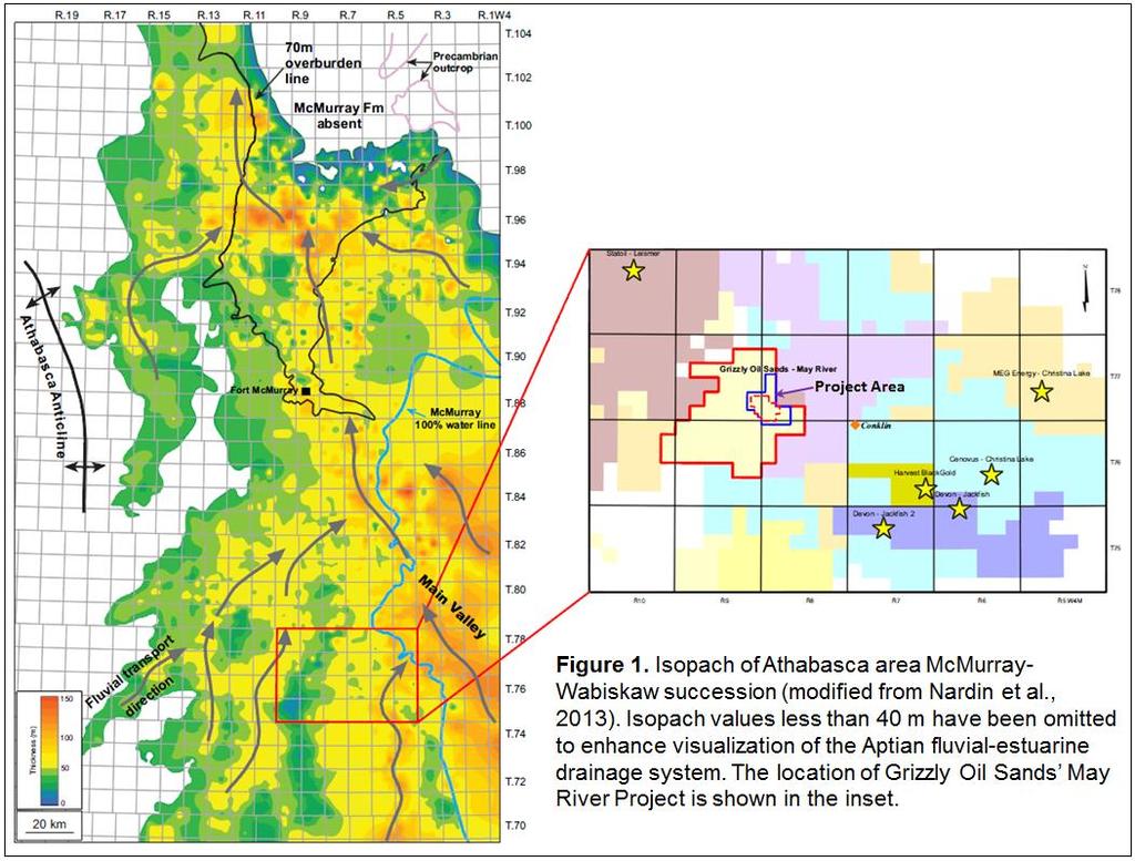
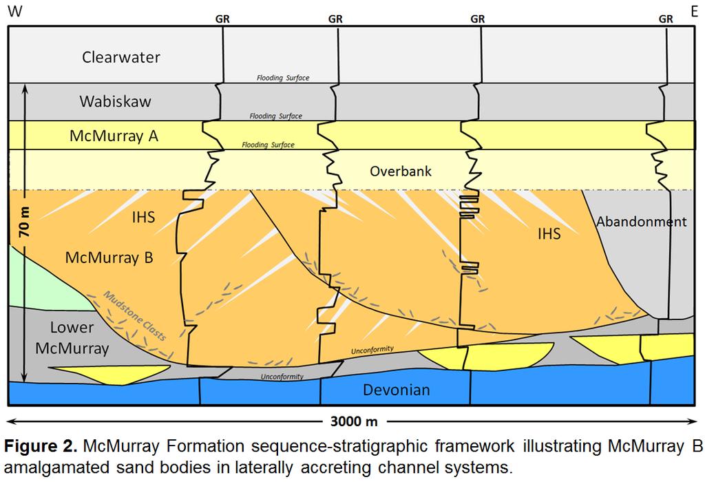
1 Modeling Lateral Accretion in McMurray Formation Fluvial- Estuarine Channel Systems: Grizzly Oil Sands May River SAGD Project, Athabasca Duncan Findlay, Thomas Nardin, Alex Wright, Raheleh Salehi Mojarad Grizzly Oil Sands ULC Introduction Large-scale fluvial-estuarine point bars and other laterally accreting channel systems in the McMurray Formation represent the most important reservoirs in the Athabasca oil sands region of Alberta. For SAGD (steam-assisted gravity drainage) developments, steam chamber growth, steam/oil ratios, productions rates and recovery efficiencies are strongly dependent on sand body thickness, connectivity and heterogeneity. As a result, an industry goal has long been the construction of geologic models and reservoir simulations that realistically represent the reservoir architecture and flow units in these complex systems (e.g., Deschamps et al, 2012, Su et al, 2013). However, until recently, computing power and software limitations necessitated the broad use of flat layered models that exhibit simple follow top or follow base layering geometries. The purpose of this paper is to present a geologic model that captures the geometries of inclined heterolithic stratification (IHS), inclined sands (IS) and their associated basal channel sands. The model integrates McMurray Formation outcrop observations with core, log and 3D seismic data from Grizzly Oil Sands May River SAGD Project. The methodology used to construct the model wherein lithofacies, petrophysical properties, and conditioning parameters are distributed chronostratigraphically are discussed. The model has been upscaled for simulation so the potential effects of IHS on steam chamber development can be investigated. Location and Stratigraphy The Grizzly Oil Sands May River property is located in Township 77, Ranges 8 and 9 W4M, approximately 14 km northwest of Conklin, Alberta (Fig. 1). Grizzly has submitted an application to the Alberta Energy Regulator in December, 2013, to develop 12,000 bpd of bitumen from the McMurray Formation using SAGD technology. At May River, the McMurray is divided into 3 stratigraphic units whose boundaries are defined by unconformities or flooding surfaces (Fig. 2). In ascending stratigraphic order these units are the Lower McMurray, McMurray B and McMurray A, respectively, using terminology adopted from the Alberta Energy and Utilities Board Report 2003-A (2003). The Lower McMurray directly overlies the sub-cretaceous unconformity and consists of thin sands, carbonaceous mudstones and rooted horizons interpreted to have been deposited in a floodplain setting. The McMurray B is incised into the Lower McMurray over most of the area and contains single-story and amalgamated multi-story channel sand bodies that are the reservoirs proposed for SAGD GeoConvention 2014: FOCUS 1
2 GeoConvention 2014: FOCUS 2

3 development. The McMurray A consists of basal mudstones and an upward-coarsening succession of very fine-grained sands characterized by wave ripples and swaley to hummocky cross stratification. This unit is interpreted to be an offshore to shoreface succession deposited in a brackish bay setting. The Wabiskaw C, a glauconitic and argillaceous sand at the base of the Clearwater Formation, overlies the McMurray A. Sedimentary structures, ichnofacies, vertical grain size trends, stratal stacking patterns, dip meter logs and seismic data indicate that the McMurray B is comprised of laterally accreting channel deposits and associated overbank sediments. The succession is similar in vertical scale (40 m) to the large-scale point bar deposits documented elsewhere in the Athabasca oil sands region (e.g., Hubbard et al, 2011; Jablonski, 2012; Nardin et al, 2013). The basal section is characterized by thick, cross-bedded channel sands. The succession generally fines upward transitioning to current rippled IS, sandy IHS and more mud-prone IHS toward the top. The degree of bioturbation also tends to increase up section. Core examples of lithofacies used in the geologic model are shown in Figure 3. Mudstone clast beds may occur anywhere in the succession and the ability to correlate them between wells depends largely on their origin (Nardin et al, 2013). Where tabular clasts have characteristics (thickness and lithology) identical to those of associated in-place IHS mudstones, the clasts are interpreted to have been derived from erosion of IHS. In this case, outcrop analogues suggest that the clast beds are oriented along the dip length of the lateral accretion surfaces (Fig. 2). As the lengths of the beds in the dip direction are typically shorter than the well spacing, these clast beds cannot be correlated. In contrast, where thick clast intervals occur near the base of a channel fill and the clast lithologies are dissimilar to associated in-place mudstones, the clasts are interpreted to be the product of cutbank erosion. These clast beds commonly mark the amalgamation of multi-story channel sands and can be correlated between wells. Matrix-supported clast facies and discontinuous clast-associated IHS are considered to be baffles to steam rise as pathways exist for bitumen drainage. GeoConvention 2014: FOCUS 3

4 Methodology and Results The geologic model encompasses the entire development area (2.6 sections) and is controlled by 27 core holes (480 m average spacing) tied to 3D seismic. The following first-order stratigraphic surfaces are represented in the model: sub-cretaceous unconformity, base McMurray B, base McMurray A, base Wabiskaw B, base lower Clearwater Shale, and Clearwater Marker. The McMurray B stratigraphy is further divided into three amalgamated channel units and a superjacent unit comprised of overbank deposits. With the exception of the McMurray B, the cells are layered to conform to the top of each zone. Although the 3D seismic data proved useful in interpreting the top and base of the McMurray B and the boundaries of individual channel trends, the pattern of lateral accretion could not be consistently determined. As a result, dipmeter data were used to identify the dominant lateral accretion dip azimuth and angle at each well location within each channel trend. These data were then used as a guide to construct curvilinear dip surfaces and inclined grids which served as the stratigraphic framework for conditioning the reservoir portion of the model. Lithofacies were upscaled and modelled in Schlumberger s Petrel software using the Sequential Indicator Simulation algorithm and following a vertical proportion curve established from lithofacies analysis. Where the areal extent of IHS lithofacies is less than the well spacing, the construction of variograms based on well data is not appropriate for two reasons. Firstly, variogram dimensions tend to converge on the average well spacing rather than on the actual lithofacies extent. Secondly, as IHS lithofacies are distributed chronostratigraphically along lateral accretion bedding, layers within the inclined grid rarely intersect more than a single well. In the May River model, variograms are based on McMurray mudstone bed length and clast distributions observed in similar facies exposed at Syncrude Canada s Mildred Lake mine (Fig. 4; Nardin et al, 2013). This approach results in more realistic stratal geometries GeoConvention 2014: FOCUS 4

5 and lithofacies distributions as illustrated in Figure 5. The pay interval is characterized by high net/gross lithofacies (S, S15, SIHS and C; Fig. 3). The net/gross tends to decrease up section, reflecting an increase in the proportion of more mud-prone IHS near the top of the section. Reservoir properties were introduced using the Sequential Gaussian Simulation algorithm keyed to each lithofacies and honoring vertical reservoir trends observed in the data. The cells are 7 m 7 m 0.3 m in size and are populated with porosity, permeability, and oil saturation values. Porosity values are determined from logs. Oil saturations are calculated from Dean Stark mass weight data and log porosities. The horizontal permeability data are populated following the porosity model as a secondary attribute. A representative block within the completed model was selected for simulation and upscaled to a resolution of 7 m 0.9 m 0.9 m. The cells in the upscaled grid are layered parallel to producer-injector well pairs in an interval from the base of the McMurray B to a height of 5 m above the injector. Above that to the top of the McMurray B, the cells are inclined parallel to the geomodel. The resulting CMG STARS simulation shows that the shape and rate of steam chamber growth is strongly influenced by the distribution of IHS lithofacies. If wells are drilled GeoConvention 2014: FOCUS 5

6 perpendicular to the direction of lateral accretion, steam tends to rise along permeable sands between muddy IHS beds (Fig. 6). Predicted steam-oil ratios and recovery factors average 2.7 and 60%, respectively. Peak oil rates per well pair range from m 3 /day. Conclusions The described methodology allows for the construction of geologic models of laterally accreting channel systems that closely mimic the stratal architecture observed in McMurray Formation outcrops and 3D seismic volumes. Variograms based on field measurements of the areal extent of IHS lithofacies are preferable to using well data alone. Models that capture lateral accretion geometries and distribute lithofacies and petrophysical properties chronostratigraphically will result in more realistic representations of flow units and improved prediction of steam steam-oil ratios, recovery efficiencies and the pattern of steam chamber growth and bitumen drainage. These models also make possible better planning of horizontal well pair trajectories. At May River, the orientations and shapes of the drainage patterns and the trajectories of the producer-injector well pairs are designed to maximize bitumen recovery based on pay trends, GeoConvention 2014: FOCUS 6
7 base of pay structure, and lateral accretion dip azimuths. Where possible, the wells are aligned at high angles to IHS dip azimuths in order to maximize bitumen drainage from pay higher in the section. References Alberta Energy and Utilities Board, 2003, Athabasca Wabiskaw-McMurray regional geological study report 2003-A: Calgary, Alberta Energy and Utilities Board, 187 p. Deschamps, R., Guy, N., Preux, C., and Lerat, O., 2012, Analysis of Heavy Oil Recovery by Thermal EOR in a Meander Belt: From Geological to Reservoir Modeling; Oil & Gas Science and Technology V 67, No. 6, p Hubbard, S. M., D. G. Smith, H. Nielsen, D. A. Leckie, M. Fustic, R. J. Spencer, and L. Bloom, 2011, Seismic geomorphology and sedimentology of a tidally influenced river deposit, Lower Cretaceous Athabasca oil sands, Alberta, Canada: AAPG Bulletin, v. 95, p Jablonski, B.V.J., Process sedimentology and three-dimensional facies architecture of a fluvial dominated, tidally influenced point bar: middle McMurray Formation, lower Steepbank River area, northeastern Alberta, Canada: Master s thesis, Department of Geological Sciences and Geological Engineering, Queen s University, Kingston, Ontario, Canada, 356 p. Nardin, T.R., Feldman, H.R., and Carter, B.J., Stratigraphic Architecture of a Large-Scale Point Bar Complex in the McMurray Formation: Syncrude s Mildred Lake Mine, Alberta, Canada. in F.J Hein et al (Eds.). Heavy-oil and Oil-sand Petroleum Systems in Alberta and Beyond. AAPG Studies in Geology 64, p Su, Y., Wang, J.Y. and Gates, I.D., 2013, SAGD well orientation in point bar oil sand deposit affects performance; Engineering Geology 157, p GeoConvention 2014: FOCUS 7
Modeling Lateral Accretion in McMurray Formation Fluvial-Estuarine Channel Systems: Grizzly Oil Sands May River SAGD Project, Athabasca*
 Modeling Lateral Accretion in McMurray Formation Fluvial-Estuarine Channel Systems: Grizzly Oil Sands May River SAGD Project, Athabasca* Duncan Findlay 1, Thomas Nardin 1, Alex Wright 1, and Raheleh Salehi
Modeling Lateral Accretion in the McMurray Formation at Grizzly Oil Sands Algar Lake SAGD Project
 Modeling Lateral Accretion in the McMurray Formation at Algar Lake SAGD Project Duncan Findlay 1, Thomas Nardin 1, Andrew Couch 2, Alex Wright 1 1 ULC, 2 EON Introduction Laterally accreting channel systems
GeoCanada 2010 Working with the Earth
 Lithofacies Identification and the Implications for SAGD Well Planning in the McMurray Formation, Christina Lake Area, Alberta Travis Shackleton*, Robert Gardner, Sung Youn, Grace Eng and Lori Barth Cenovus
Introduction. Milovan Fustic 1, Rudy Strobl 1, Bryce Jablonski 1, Torgrim Jacobsen 2, Eirik Vik 2, and Allard W. Martinius 1
 McMurray Formation Type Section Outcrop: Part 1 - a world class learning lab for fluvio - tidal sedimentology, petroleum systems and reservoir characterization & Part 2 an unparalleled portal for SAGD
Effect on SAGD Performance of Horizontal Well Orientation with Respect to Inclined Shale Layers and Point Bars*
 Effect on SAGD Performance of Horizontal Well Orientation with Respect to Inclined Shale Layers and Point Bars* Amir Zamani 1 and Ron Zakariasen 1 Search and Discovery Article #41334 (2014) Posted May
AAPG Search and Discovery Article #90173 CSPG/CSEG/CWLS GeoConvention 2011, Calgary, Alberta, Canada, May 9-11, 2011
 Use of Image Logs in Differentiating Point Bar and Tidal Bar Deposits in the Leismer Area: Implications for SAGD Reservoir Definition in the Athabasca Oilsands Howard Brekke and Andrew Couch Introduction
LOWER GRAND RAPIDS BITUMEN POOLS AT COLD LAKE, ALBERTA VARIATIONS IN STRATIGRAPHIC SETTING AND DEPOSITIONAL ENVIRONMENTS
 RAPIDS BITUMEN POOLS AT COLD LAKE, ALBERTA VARIATIONS IN STRATIGRAPHIC SETTING AND DEPOSITIONAL ENVIRONMENTS Brad J. Hayes, Petrel Robertson Consulting Ltd. Garrett M. Quinn, OSUM Oil Sands Corp. Summary
Stochastic Simulation of Inclined Heterolithic Stratification with Streamline-based Stochastic Models
 Stochastic Simulation of Inclined Heterolithic Stratification with Streamline-based Stochastic Models Michael J. Pyrcz and Clayton V. Deutsch Department of Civil and Environmental Engineering, University
Abstract. Bryce V.J. Jablonski, Rudolph Strobl, Milovan Fustic, Allard W. Martinius Heavy Oil Technology Centre, Statoil Canada
 Not All IHS Was Created Equal- A retrospective and prospective look at inclined heterolithic stratification of tidal-fluvial point bars of the middle McMurray Formation of Northeastern Alberta, Canada
Modelling of 4D Seismic Data for the Monitoring of the Steam Chamber Growth during the SAGD Process
 Renewable energies Eco-friendly production Innovative transport Eco-efficient processes Sustainable resources Modelling of 4D Seismic Data for the Monitoring of the Steam Chamber Growth during the SAGD
Time to Depth Conversion and Uncertainty Characterization for SAGD Base of Pay in the McMurray Formation, Alberta, Canada*
 Time to Depth Conversion and Uncertainty Characterization for SAGD Base of Pay in the McMurray Formation, Alberta, Canada* Amir H. Hosseini 1, Hong Feng 1, Abu Yousuf 1, and Tony Kay 1 Search and Discovery
3D Geological Modeling and Uncertainty Analysis of Pilot Pad in the Long Lake Field with Lean Zone and Shale Layer
 Datapages/Search and Discovery Article #9224 GeoConvention 214, FOCUS - Adapt, Refine, Sustain Calgary, Alberta, Canada, May 12-16, 214 3D Geological Modeling and Uncertainty Analysis of Pilot Pad in the
Quantitative Seismic Interpretation An Earth Modeling Perspective
 Quantitative Seismic Interpretation An Earth Modeling Perspective Damien Thenin*, RPS, Calgary, AB, Canada TheninD@rpsgroup.com Ron Larson, RPS, Calgary, AB, Canada LarsonR@rpsgroup.com Summary Earth models
Best Practice Reservoir Characterization for the Alberta Oil Sands
 Best Practice Reservoir Characterization for the Alberta Oil Sands Jason A. McLennan and Clayton V. Deutsch Centre for Computational Geostatistics (CCG) Department of Civil and Environmental Engineering
Sedimentary and Stratigraphic Analysis of the Viking Sand in the Edgerton/Wainwright Area, Central Alberta* By Russell Walz 1
 Sedimentary and Stratigraphic Analysis of the Viking Sand in the Edgerton/Wainwright Area, Central Alberta* By Russell Walz 1 Search and Discovery Article #50030 (2006) Posted June 25, 2006 *Extended abstract
Anatomy of a Fluvial to Estuarine Valley Fill, North Cactus Lake McLaren Reservoir
 Anatomy of a Fluvial to Estuarine Valley Fill, North Cactus Lake McLaren Reservoir J. Edward Mathison Alethia Geologica, Filling of the north Cactus Lake post Waseca paleovalley, during McLaren sea level
Geologic Considerations of Shallow SAGD Caprock; Seal Capacity, Seal Geometry and Seal Integrity, Athabasca Oilsands, Alberta Canada
 Geologic Considerations of Shallow SAGD Caprock; Seal Capacity, Seal Geometry and Seal Integrity, Athabasca Oilsands, Alberta Canada Gordon T. Stabb, Michael Webb Durando Resources Corp, Suncor Energy
Summary. Introduction. Observations and Interpretations
 Lower McMurray Formation sinkholes and their fill fabrics: effects of salt dissolution collapse-subsidence across the northern Athabasca oil sands deposit Paul L. Broughton, Chevron Canada Resources, Calgary,
High-resolution Sequence Stratigraphy of the Glauconitic Sandstone, Upper Mannville C Pool, Cessford Field: a Record of Evolving Accommodation
 Page No. 069-1 High-resolution Sequence Stratigraphy of the Glauconitic Sandstone, Upper Mannville C Pool, Cessford Field: a Record of Evolving Accommodation Thérèse Lynch* and John Hopkins, Department
Glauconitic Oil Reservoirs in Southern Alberta Creating the Correct Geological Model to Guide Development Drilling
 Glauconitic Oil Reservoirs in Southern Alberta Creating the Correct Geological Model to Guide Development Drilling Brad Hayes* Petrel Robertson Consulting Ltd, Calgary, AB bhayes@petrelrob.com Lisa Griffith
Unlocking the NMR Potential in Oil Sands
 Unlocking the NMR Potential in Oil Sands Kevin J. Pyke Nexen Energy ULC Abstract The Lower Cretaceous McMurray Formation in Alberta is the primary bitumen producing horizon in the Long Lake and Kinosis
Core Examples from Modern Estuarine Tidal Bars, Tillamook Bay, Oregon
 Core Examples from Modern Estuarine Tidal Bars, Tillamook Bay, Oregon Rares Bistran* University of Alberta, Edmonton, Alberta, Canada rares.bistran@ualberta.ca David Herbers, Murray Gingras, John-Paul
CHEMOSTRAT. Marta Barbarano, Gemma Hildred, Tim Pearce
 CHEMOSTRAT Geographical and stratigraphical provenance changes in the Lower Cretaceous McMurray Formation, Alberta, Canada, as revealed by heavy mineral analysis and detrital zircon U-Pb geochronology
A Review of McMurray Formation Geology in Athabasca Oil Sands
 A Review of McMurray Formation Geology in Athabasca Oil Sands Rahman M. Hassanpour The Northern Alberta oil sands, containing the Athabasca, Peace River and Cold Lakes areas, are the largest oil sands
Reservoir characterization
 1/15 Reservoir characterization This paper gives an overview of the activities in geostatistics for the Petroleum industry in the domain of reservoir characterization. This description has been simplified
Bulletin of Earth Sciences of Thailand
 Depositional Environments and Stratigraphic Development of the Grand Taman Sari Circuit Outcrop: an Analogue for Transgressive Mahakam Delta Successions Ridha Santika Riadi Petroleum Geoscience Program,
3D geologic modelling of channellized reservoirs: applications in seismic attribute facies classification
 first break volume 23, December 2005 technology feature 3D geologic modelling of channellized reservoirs: applications in seismic attribute facies classification Renjun Wen, * president and CEO, Geomodeling
Facies Analysis of the Lower Cretaceous Wilrich Member (Lower Falher) of the Spirit River Formation.
 of the Spirit River Formation.") Facies Analysis of the Lower Cretaceous Wilrich Member (Lower Falher) of the Spirit River Formation. Kerrie L. Bann, Ichnofacies Analysis Inc. and Daniel J. K. Ross, Tourmaline Oil Corp. Historically,
Facies Analysis of the Lower Cretaceous Wilrich Member (Lower Falher) of the Spirit River Formation. Kerrie L. Bann, Ichnofacies Analysis Inc. and Daniel J. K. Ross, Tourmaline Oil Corp. Historically,
Sarah Jane Riordan. Australian School of Petroleum University of Adelaide March 2009
 Managing the Interdisciplinary Requirements of 3D Geological Models Sarah Jane Riordan Australian School of Petroleum University of Adelaide March 2009 Thesis submitted in accordance with the requirements
Reanalyzing Thermocouple Temperature Response for Evidence of Convective Flow. Mohammad Aghabarati
 Reanalyzing Thermocouple Temperature Response for Evidence of Convective Flow by Mohammad Aghabarati A thesis submitted in partial fulfillment of the requirements for the degree of Master of Science in
An Overview of the Tapia Canyon Field Static Geocellular Model and Simulation Study
 An Overview of the Tapia Canyon Field Static Geocellular Model and Simulation Study Prepared for Sefton Resources Inc. Jennifer Dunn, Chief Geologist Petrel Robertson Consulting Ltd. Outline Background
Prediction of Shale Plugs between Wells in Heavy Oil Sands using Seismic Attributes
 GRAY, F. DAVID *, PAUL F. ANDERSON, and JAY A. GUNDERSON *, * Veritas DGC, Calgary, AB, Canada, Apache Canada Ltd., Calgary, AB, Canada Prediction of Shale Plugs between Wells in Heavy Oil Sands using
Cored Successions from a Modern Estuarine Channel, Willapa Bay, Washington
 Cored Successions from a Modern Estuarine Channel, Willapa Bay, Washington Jesse Schoengut* University of Alberta, Edmonton, Alberta, Canada jesse@ualberta.ca Greg Baniak, Rares Bistran, Luke McHugh, S.
Facies Analysis Of The Reservoir Rocks In The. Sylhet Trough, Bangladesh. Abstract
 Facies Analysis Of The Reservoir Rocks In The Sylhet Trough, Bangladesh Joyanta Dutta Petroleum Geoscience Program, Department of Geology, Faculty of Science, Chulalongkorn University, Bangkok 10330, Thailand
Modeling of Intra-Channel Belt Depositional Architecture in Fluvial Reservoir Analogs from the Lourinha Formation, Portugal*
 Modeling of Intra-Channel Belt Depositional Architecture in Fluvial Reservoir Analogs from the Lourinha Formation, Portugal* Anneli Ekeland 1, Nina Pedersen 1, John Howell 1, Wojtek Nemec 2, Kevin Keogh
3rd-order sequence stratigraphy and lithostratigraphy of the Bearpaw Horseshoe Canyon transition, Alberta plains
 3rd-order sequence stratigraphy and lithostratigraphy of the Bearpaw Horseshoe Canyon transition, Alberta plains Ben Hathway, Alberta Geological Survey, Alberta Energy Regulator, Edmonton, Alberta, ben.hathway@aer.ca
Lab 8: Facies Analysis and Correlations: Sequence Stratigraphy in the Book Cliffs, Utah
 Geology 109L Lab 8: Facies Analysis and Correlations: Sequence Stratigraphy in the Book Cliffs, Utah Goal: In this lab, you will put together your knowledge of near-shore facies and sequence stratigraphy
Linking Channel-Margin Bed Thickness to Hydrodynamics in the Tidally Influenced Fraser River, British Columbia*
 Linking Channel-Margin Bed Thickness to Hydrodynamics in the Tidally Influenced Fraser River, British Columbia* Andrew La Croix 1, Shahin Dashtgard 1, and James MacEachern 1 Search and Discovery Article
Structural Deformation and Karst in the Devonian Waterways Formation: Examples from Outcrops along the Athabasca River*
 Structural Deformation and Karst in the Devonian Waterways Formation: Examples from Outcrops along the Athabasca River* Chris L. Schneider 1 and Matthias Grobe 2 Search and Discovery Article #51073 (2015)
Grand Rapids Oil Sands 3D Seismic Incorporating and Comparing Multiple Data Types for Reservoir Characterization
 Grand Rapids Oil Sands 3D Seismic Incorporating and Comparing Multiple Data Types for Reservoir Characterization Laurie M. Weston Bellman* Oil Sands Imaging Inc., Calgary, Alberta laurie@oilsandsimaging.com
Hydrocarbon Distribution in the Mannville Waseca Member, Edam Oil Field, West-central Saskatchewan
 Hydrocarbon Distribution in the Mannville Waseca Member, Edam Oil Field, West-central Saskatchewan Peter Hill 1 Information from this publication may be used if credit is given. It is recommended that
The Clearwater Formation: A Facies Study for SAGD Water Source in the Athabasca Oil Sands
 The Clearwater Formation: A Facies Study for SAGD Water Source in the Athabasca Oil Sands Wallace, J. and Lavigne, J Introduction Water source has become an increasingly important issue recently with the
UNIVERSITY OF CALGARY. Impact of Point Bar Architecture on the Performance of SAGD. Yi Su A THESIS SUBMITTED TO THE FACULTY OF GRADUATE STUDIES
 UNIVERSITY OF CALGARY Impact of Point Bar Architecture on the Performance of SAGD by Yi Su A THESIS SUBMITTED TO THE FACULTY OF GRADUATE STUDIES IN PARTIAL FULFILMENT OF THE REQUIREMENTS FOR THE DEGREE
RESERVOIR CHARACTERISATION
 Introducing geological processes in reservoir models Reservoir modelling and reservoir simulation are based on data collected at multiple scales with resolution ranging from sub-millimetre to tens of metres.
Tom Sneddon 1. Search and Discovery Article # (2015)** Posted September 7, Abstract
** Posted September 7, Abstract") AV Geoscience and Professionalism* Tom Sneddon 1 Search and Discovery Article #110222 (2015)** Posted September 7, 2015 *Adapted from presentation at the AAPG DPA Playmaker, Calgary, Alberta, March 31,
AV Geoscience and Professionalism* Tom Sneddon 1 Search and Discovery Article #110222 (2015)** Posted September 7, 2015 *Adapted from presentation at the AAPG DPA Playmaker, Calgary, Alberta, March 31,
Summary. Introduction
 Orthogonal geometrics of lower McMurray Formation sand complexes: effects of salt dissolution collapse-subsidence across the northern Athabasca oil sands deposit Paul L. Broughton, Chevron Canada Resources,
6. Cretaceous Zone Play Results
 C H A P T E R S I X 6. Cretaceous Zone Play Results 6. Geological Overview The Mannville Group was deposited as a clastic wedge east of the mountain ranges. This wedge varies in thickness from 7 metres
Study of the impact of heterogeneity on the modeling of fluid-flow, based on a turbidite reservoir analogue Ainsa-1 quarry outcrop, Spain
 Study of the impact of heterogeneity on the modeling of fluid-flow, based on a turbidite reservoir analogue Ainsa-1 quarry outcrop, Spain Master of Sciences thesis Submitted by: Erica Garrido Magaz In
- Cased-hole geophysical well logs - Airborne geophysics - Seismic data - LiDAR. GeoConvention 2015: New Horizons 1
 Thermal Effects and Quaternary Hydrogeology: Making Good Decisions in a Complex Geologic Setting Timothy Johnsen, Phd, Quaternary Specialist (tjohnsen@matrix-solutions.com) Alex Haluszka, MSc, P.Geol.,
Sequence Stratigraphic Framework and Reservoir Architecture of the Lingshui-3 Member, Yacheng 13-1 Gas Field, South China Sea
 Sequence Stratigraphic Framework and Reservoir Architecture of the Lingshui-3 Member, Yacheng 13-1 Gas Field, South China Sea David Z. Tang BP China Exploration and Production Company 17/F, Finance Centre,
Athabasca Oil Sands Corp.
 2011 ABERCB 012 Athabasca Oil Sands Corp. Requests for Interim Shut-in of Gas Liege Field Athabasca Oil Sands Area May 10, 2011 ENERGY RESOURCES CONSERVATION BOARD Decision 2011 ABERCB 012: Athabasca Oil
Reservoir Characterization of the Swan Hills Eastern Platform Trend; a Multi-disciplinary Approach in Building an Applied Model
 Reservoir Characterization of the Swan Hills Eastern Platform Trend; a Multi-disciplinary Approach in Building an Applied Model Thanos A. Natras*, Arcan Resources Ltd., Calgary, Alberta tnatras@arcanres.com
The Origin of Matrix and Fracture Mega- Porosity in a Carbonate Bitumen Reservoir, Grosmont Formation, Saleski, Alberta T 85 R 19W4M
 The Origin of Matrix and Fracture Mega- Porosity in a Carbonate Bitumen Reservoir, Grosmont Formation, Saleski, Alberta T 85 R 19W4M Kent Barrett, Dr John Hopkins, Ken Wilde and Marnie Connelly Oct 2/07
The Hangingstone steam-assisted gravity drainage
 SPECIAL Heavy SECTION: oil H e a v y o i l Elastic property changes in a bitumen reservoir during steam injection AYATO KATO, University of Houston, USA SHIGENOBU ONOZUKA, JOGMEC, Chiba, Japan TORU NAKAYAMA,
Case Study of the Structural and Depositional-Evolution Interpretation from Seismic Data*
 Case Study of the Structural and Depositional-Evolution Interpretation from Seismic Data* Yun Ling 1, Xiangyu Guo 1, Jixiang Lin 1, and Desheng Sun 1 Search and Discovery Article #20143 (2012) Posted April
Dalhousie University- Petroleum Geoscience Field Methods- Trinidad Summary Report
 Dalhousie University- Petroleum Geoscience Field Methods- Trinidad Summary Report Submitted to: Offshore Energy Research Association of Nova Scotia (OERA) To fulfill requirements of the Undergraduate Student
The unknown giants - low-permeability shallow gas reservoirs of southern Alberta and Saskatchewan, Canada.
 The unknown giants - low-permeability shallow gas reservoirs of southern Alberta and Saskatchewan, Canada. Shaun O'Connell* Belfield Resources Inc., Calgary belfield@shaw.ca ABSTRACT The gas reserves contained
Sedimentary System Characteristics of Deng-3 Section on Paleo-central. Uplift Belt in Northern Songliao Basin. Siyang Li1,a*
 Sedimentary System Characteristics of Deng-3 Section on Paleo-central Uplift Belt in Northern Songliao Basin Siyang Li1,a* 1 School of Earth Sciences and Resources, China University of Geosciences, Beijing,
EMEKA M. ILOGHALU, NNAMDI AZIKIWE UNIVERSITY, AWKA, NIGERIA.
 Automatic classification of lithofacies and interpretation of depositional environment using Neural Networks Technique - A Novel Computer-Based methodology for 3-D reservoir geological modelling and exploration
Carbonates vs Clastics How the Differences Impact our SAGD Assessments. Caralyn Bennett, P. Eng. July 6, 2011
 Carbonates vs Clastics How the Differences Impact our SAGD Assessments Caralyn Bennett, P. Eng. July 6, 2011 Source: Alberta Geological Survey Formations Prospective for Oil Sands Carbonates Clastics
Conventional oil petroleum system of the Cenomanian - Turonian Blackstone Formation, Ferrier - Willesden Green - Gilby area, west-central Alberta
 Conventional oil petroleum system of the Cenomanian - Turonian Blackstone Formation, Ferrier - Willesden Green - Gilby area, west-central Alberta Kevin Greff, Department of Earth Sciences, Western University,
SPE PP. Abstract
 SPE 147302-PP EVALUATION OF THE CLEARWATER FORMATION CAPROCK FOR A PROPOSED, LOW PRESSURE, STEAM-ASSISTED GRAVITY-DRAINAGE PILOT PROJECT IN NORTHEAST ALBERTA M.M.E. Uwiera-Gartner, RPS Energy Canada Ltd.,
Outcrops from Every Continent and 20 Countries in 140 Contributions. Tor H. Nilsen, Roger D. Shew, Gary S. Steffens, and Joseph R.J. Studlick.
 Paper VIII Tor H. Nilsen, Roger D. Shew, Gary S. Steffens, and Joseph R.J. Studlick Editors Outcrops from Every Continent and 20 Countries in 140 Contributions http://bookstore.aapg.org Length ~ 23 m (75.5
The SPE Foundation through member donations and a contribution from Offshore Europe
 Primary funding is provided by The SPE Foundation through member donations and a contribution from Offshore Europe The Society is grateful to those companies that allow their professionals to serve as
Bulletin of Earth Sciences of Thailand. Controls on Reservoir Geometry and Distribution, Tantawan Field, Gulf of Thailand.
 Controls on Reservoir Geometry and Distribution, Tantawan Field, Gulf of Thailand Atchara Praidee Petroleum Geoscience Program, Department of Geology, Faculty of Science, Chulalongkorn University, Bangkok
Bulletin of Earth Sciences of Thailand
 Quantitative Seismic Geomorphology of Early Miocene to Pleistocene Fluvial System of Northern Songkhla Basin, Gulf of Thailand Oanh Thi Tran Petroleum Geoscience Program, Department of Geology, Faculty
ALBERTA S CARDIUM OIL AND THE EVOLUTION OF CUTOFFS AND EVALUATION PROCEDURES IN RESPONSE TO HORIZONTAL DRILLING
 ALBERTA S CARDIUM OIL AND THE EVOLUTION OF CUTOFFS AND EVALUATION PROCEDURES IN RESPONSE TO HORIZONTAL DRILLING Alberta s Cardium Oil and the Evolution of Cutoffs and Evaluation Procedures in Miranda Stoffman,
Downloaded 11/12/18 to Redistribution subject to SEG license or copyright; see Terms of Use at
 t Technical papers Downloaded 11/12/18 to 144.94.32.4. Redistribution subject to SEG license or copyright; see Terms of Use at http://library.seg.org/ Fluvial architecture of the Burro Canyon Formation
SUPPLEMENTAL INFORMATION DELFT 3-D MODELING: MODEL DESIGN, SETUP, AND ANALYSIS
 GSA DATA REPOSITORY 2014069 Hajek and Edmonds SUPPLEMENTAL INFORMATION DELFT 3-D MODELING: MODEL DESIGN, SETUP, AND ANALYSIS Each experiment starts from the initial condition of a straight channel 10 km
Facies Modeling in Presence of High Resolution Surface-based Reservoir Models
 Facies Modeling in Presence of High Resolution Surface-based Reservoir Models Kevin Zhang Centre for Computational Geostatistics Department of Civil and Environmental Engineering University of Alberta
CLASTICS FIELD TRIP. Dynamic stratigraphy, facies, architecture and fracture analysis of coastal depositional systems
 CLASTICS FIELD TRIP Dynamic stratigraphy, facies, architecture and fracture analysis of coastal depositional systems MAY 2-5 SEPTEMBER 17-20, 2018 Appraisal and development of clastic reservoirs rely on
INTEGRATED RESERVOIR CHARACTERIZATION AND MODELING
 INTEGRATED RESERVOIR CHARACTERIZATION AND MODELING Mickaele Le Ravalec Brigitte Doligez Olivier Lerat ISBN: 2-901638-15-5 EAN: 9782901638155 Chapter 3 Book DOI: 10.2516/ifpen/2014001 Chapter 3 DOI: Chapter
Sequence Stratigraphy: An Applied Workshop
 Sequence Stratigraphy: An Applied Workshop Instructor: Prof. Octavian Catuneanu Level: Intermediate Duration: 5 days Course Description and Objectives This workshop presents the concepts and practical
Investigation of Devonian Unconformity Surface Using Legacy Seismic Profiles, NE Alberta
 Investigation of Devonian Unconformity Surface Using Legacy Seismic Profiles, NE Alberta Elahe P. Ardakani and Douglas R. Schmitt Department of Physics, University of Alberta Summary The Devonian Grosmont
SAND DISTRIBUTION AND RESERVOIR CHARACTERISTICS NORTH JAMJUREE FIELD, PATTANI BASIN, GULF OF THAILAND
 SAND DISTRIBUTION AND RESERVOIR CHARACTERISTICS NORTH JAMJUREE FIELD, PATTANI BASIN, GULF OF THAILAND Benjawan KIinkaew Petroleum Geoscience Program, Department of Geology, Faculty of Science, Chulalongkorn
Data Repository item
 Data Repository (B25407): Localities and descriptions of measured sections of study areas Table 1. Localities of the measured sedimentary sections in the NW Sichuan Basin Section Number Stratigraphy Locality
Dakota Sandstone. of the Moxa Arch and Surrounding Green River Basin
 Dakota Sandstone of the Moxa Arch and Surrounding Green River Basin Dakota Sandstones of the Green River Basin Overview The Dakota sandstones of the Moxa Arch and surrounding Green River Basin remain attractive
Geostatistical Determination of Production Uncertainty: Application to Firebag Project
 Geostatistical Determination of Production Uncertainty: Application to Firebag Project Abstract C. V. Deutsch, University of Alberta (cdeutsch@civil.ualberta.ca) E. Dembicki and K.C. Yeung, Suncor Energy
Seismic Attributes and Their Applications in Seismic Geomorphology
 Academic article Seismic Attributes and Their Applications in Seismic Geomorphology Sanhasuk Koson, Piyaphong Chenrai* and Montri Choowong Department of Geology, Faculty of Science, Chulalongkorn University,
GYPSY FIELD PROJECT IN RESERVOIR CHARACTERIZATION
 GYPSY FIELD PROJECT IN RESERVOIR CHARACTERIZATION Contract Number: DE-FG22-95BC14869 Contractor: Contract Date: University of Oklahoma Center for Reservoir Char act erization Norman, Oklahoma 73019 April
Accommodation. Tectonics (local to regional) Subsidence Uplift
 Subsidence Uplift") Accommodation Accommodation varies over time; it is the distance between a reference horizon and the sea surface (i.e. relative sea level). The space to be filled in with sediments or water What are the
Accommodation Accommodation varies over time; it is the distance between a reference horizon and the sea surface (i.e. relative sea level). The space to be filled in with sediments or water What are the
Gas over Bitumen in North Eastern Alberta
 Gas over Bitumen in North Eastern Alberta Was the Alberta Energy and Utility Board s blanket shut-in approach appropriate? Prepared by: Brad Wooley Student ID: 0327273 Professor: Joseph Doucette Class:
Block 43B - Onshore Oman
 Block 43B - Onshore Oman SUMMARY Block 43B is an 11,967 km 2 area located along the coastal area of Oman north of the Hajar Mountains. This is an unexplored region, both geographically and stratigraphically.
Search and Discovery Article #20097 (2011) Posted January 31, 2011
 Posted January 31, 2011") Integrated Geological and Engineering Studies in Support of Producing Light Oil from a Frozen Reservoir: A Case Study from Umiat Oil Field, Northern Alaska* C. Hanks 1, J. Mongrain 2, A. Dandekar 2, P.
Integrated Geological and Engineering Studies in Support of Producing Light Oil from a Frozen Reservoir: A Case Study from Umiat Oil Field, Northern Alaska* C. Hanks 1, J. Mongrain 2, A. Dandekar 2, P.
Fluid-Mud Deposits of the Lower Jurassic Tilje Formation, Offshore Mid-Norway By Aitor A. Ichaso and Robert W. Dalrymple 1
 Fluid-Mud Deposits of the Lower Jurassic Tilje Formation, Offshore Mid-Norway By Aitor A. Ichaso and Robert W. Dalrymple 1 Search and Discovery Article #50107 (2008) Posted August 10, 2008 *Adapted from
Viking Lowstand Deposits in West Central Saskatchewan: Depositional Model for the Reservoir Units in Dodsland-Hoosier Area, Saskatchewan, Canada
 Viking Lowstand Deposits in West Central Saskatchewan: Depositional Model for the Reservoir Units in Dodsland-Hoosier Area, Saskatchewan, Canada Hasan Ferdous* PetroSed Geoconsulting Resources, Calgary,
Bulletin of Earth Sciences of Thailand. A study of Reservoir Connectivity in the Platong Field, Pattani Basin, Gulf of Thailand. Hathairat Roenthon
 A study of Reservoir Connectivity in the Platong Field, Pattani Basin, Gulf of Thailand Hathairat Roenthon Petroleum Geoscience Program, Department of Geology, Faculty of Science, Chulalongkorn University,
Search and Discovery Article #80372 (2014) Posted May 12, 2014
 Posted May 12, 2014") Paleozoic Stratigraphic Framework beneath the Muskeg River Mine, Northeastern Alberta (Twp 95, Rge 9-10W4): Controls and Constraints on Present Day Hydrogeology* R. Mahood 1, M. Verhoef 1, and F.A. Stoakes
Paleozoic Stratigraphic Framework beneath the Muskeg River Mine, Northeastern Alberta (Twp 95, Rge 9-10W4): Controls and Constraints on Present Day Hydrogeology* R. Mahood 1, M. Verhoef 1, and F.A. Stoakes
Study on the Couple of 3D Geological Model and Reservoir Numerical Simulation Results
 Advances in Petroleum Exploration and Development Vol. 13, No. 2, 2017, pp. 43-47 DOI:10.3968/9663 ISSN 1925-542X [Print] ISSN 1925-5438 [Online] www.cscanada.net www.cscanada.org Study on the Couple of
PECIKO GEOLOGICAL MODELING: POSSIBLE AND RELEVANT SCALES FOR MODELING A COMPLEX GIANT GAS FIELD IN A MUDSTONE DOMINATED DELTAIC ENVIRONMENT
 IATMI 2005-29 PROSIDING, Simposium Nasional Ikatan Ahli Teknik Perminyakan Indonesia (IATMI) 2005 Institut Teknologi Bandung (ITB), Bandung, 16-18 November 2005. PECIKO GEOLOGICAL MODELING: POSSIBLE AND
Carboniferous Stoddart Group: An integrated approach
 Carboniferous Stoddart Group: An integrated approach Abu Yousuf*, Department of Geoscience, University of Calgary, Calgary, Alberta yousufabu@hotmail.com and Charles M. Henderson, Department of Geoscience,
Lecture 19: Fluvial Facies
 GEOL 440 Sedimentology and stratigraphy: processes, environments and deposits Lecture 19: Fluvial Facies Aims Examine controls on alluvial channel pattern List the types of channel pattern Examine meandering
Structure and Isopach Mapping of the Lower Cretaceous Dina Member of the Mannville Group of Northwestern Saskatchewan
 Structure and Isopach Mapping of the Lower Cretaceous Dina Member of the Mannville Group of Northwestern Saskatchewan Dan Kohlruss, Per Kent Pedersen 1, and Guoxiang Chi 2 Kohlruss, D., Pedersen, P.K.,
Conditional Simulation of Subseismic Mega Karstic Features
 Conditional Simulation of Subseismic Mega Karstic Features Amir H. Hosseini and Clayton V. Deutsch The prediction of the location and size of mega karstic features such as sinkholes and caves in carbonate
Downloaded 09/15/16 to Redistribution subject to SEG license or copyright; see Terms of Use at
 A Full Field Static Model of the RG-oil Field, Central Sirte Basin, Libya Abdalla Abdelnabi*, Kelly H. Liu, and Stephen Gao Missouri University of Science and Technology Summary Cambrian-Ordovician and
Large-Scale Stratigraphic Architecture of a Deep-Water Slope Conduit, Nanaimo Group, Hornby Island, Canada
 Large-Scale Stratigraphic Architecture of a Deep-Water Slope Conduit, Nanaimo Group, Hornby Island, Canada Heather A. Bain 1 and Stephen M. Hubbard 1 1 Department of Geoscience, University of Calgary Introduction
Chapter 8: Learning objectives
 Chapter 8: Learning objectives Understand concept of sedimentary facies Signinifance of lateral and vertical facies associations Walther s Law Understand the sedimentary facies of alluvial fans, eolian
The 3-D Seismic Geomorphology of Deep-Water Slope Channel Systems A Case Study from the Deep Water Nile Delta
 Geological Society of Trinidad & Tobago The 3-D Seismic Geomorphology of Deep-Water Slope Channel Systems A Case Study from the Deep Water Nile Delta Nigel E. Cross Presentation Outline Introduction Deep
Risk Factors in Reservoir Simulation
 Risk Factors in Reservoir Simulation Dr. Helmy Sayyouh Petroleum Engineering Cairo University 12/26/2017 1 Sources Of Data Petro-physical Data Water saturation may be estimated from log analysis, capillary
Exploration Significance of Unconformity Structure on Subtle Pools. 1 Vertical structure characteristics of unconformity
 Exploration Significance of Unconformity Structure on Subtle Pools Wu Kongyou (China University of Petroleum,College of Geo-Resources and Information,Shandong Qingdao 266555) Abstract: Vertical structure