SEASONAL WATER STORAGE AND REPLENISHMENT OF A FRACTURED GRANITE AQUIFER USING ASR WELLS
|
|
|
- Dortha Scott
- 5 years ago
- Views:
Transcription


1 SEASONAL WATER STORAGE AND REPLENISHMENT OF A FRACTURED GRANITE AQUIFER USING ASR WELLS Mario R. Lluria; Phillip M. Paski; Gary G. Small HydroSystems, Incorporated Phoenix, Arizona USA
2 Presentation Contents Managed Aquifer Recharge Development in Arizona The Payson M.A.R. Project Water Resources Availability and Challenges Water Supply Alternatives and Solutions Hydrogeologic Framework Regional Geology Local Geology Hydrogeology Hydrogeochemistry Water Chemistry of the Cragin Reservoir Spring and Groundwater Chemistry Impacts of Blending Reservoir Water and Groundwater Geophysical Studies Evaluation of A.S.R. A.S.R. Well Field Operation Conclusions

")

3 M.A.R. in Arizona Main Reason For Its Progress 1980 Groundwater Management Act Central Arizona Project (CAP) Aqueduct Excess CAP Water Storage Issue Water Reclamation and Storage Insufficient Direct Use Intensive Aquifer Use


4 M.A.R. in Arizona Development Phases Phase I Experimental Studies Phase II Demonstration Projects Phase III Large Storage Capacity Water- Spreading Facilities Phase IV Intermediate to Small Storage Capacity Facilities
 Near SRP and CAP water infrastructure Started operation in 1994 Total cost $2.")
5 Water-Spreading Facilities GRUSP Development In-channel basins in the Salt River Recharge capacity 100,000 ac-ft/yr (123,300,000 m 3 /yr) Near SRP and CAP water infrastructure Started operation in 1994 Total cost $2.2M
6 Water Spreading Facilities GRUSP and NAUSP W White Tank Mountains Agua Fria River NAUSP Salt River GRUSP E McDowell Mountains Red Mountains UAU MAU LAU UAU MAU LAU West Salt River Valley Basin East Salt River Valley Basin


 < 5,000")


7 M.A.R. in Arizona Water-Spreading vs Well Recharge Capacity Water-Spreading ASR Well Vadose Zone Well 5, ,000 ac-ft/yr (6,165, ,950,000 m 3 /yr) < 5,000 ac-ft/d (<6,165,000 m 3 /d) Water Source CAP, RW, S&V, Mixed RW, CAP RW Unit Cost ($/ac-ft) Very low High Intermediate 1,000 15,000 ac-ft/yr (1,233,000 18,495,000 m 3 /yr) Number of Facilities

8 TOWN OF PAYSON AQUIFER STORAGE AND RECOVERY PROJECT
9 Water Resources and Challenges Groundwater is currently the sole source of supply The aquifer is a fractured granite Individual well production ranges from liters/second 42 production wells meet daily peak and annual demand of 3,108,000 m 3 /yr Extreme drought pressures these limited groundwater supplies Long-term sustainability requires additional water supplies
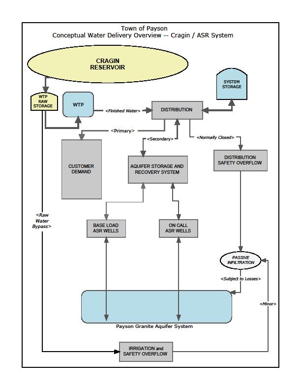
10 Water Supply Solution Arizona Water Settlements Act of 2004 with the Completion of the Cragin Pipeline Project (Blue Ridge). Diversifies the supply portfolio by adding 3,700,500 m 3 /year. The Cragin Project entails a ~15 mile pipeline, a combo hydro-generation/water treatment plant facility, and in-town improvements. Annual allocation will be delivered over 9-months due to weather conditions. Innovative conjunctive use strategies which bring groundwater, surface water, and reclaimed water sources together, can lead Payson to water supply sustainability, even within our drought sensitive environment.
11 Water Supply Solution Groundwater production areas which were once over pumped are now planned for seasonal and long-term storage recovery of surface water through Aquifer Storage and Recovery Wells ASR The use of ASR will meet seasonal needs while also helping to restore previously depleted groundwater areas ASR storage capacity in the aquifer is estimated at 15,420,000 m 3 but seasonal recovery of over 7,000 acre-ft is anticipated between When 100% full the aquifer is estimated to hold a minimum of 27,200,000 m 3 of recoverable water Over 15 years, approximately 6,800,000 m 3 of injected surface water may remain in the aquifer to augment natural recharge. Therefore, pre-pumping aquifer conditions should be restored via ASR wells and natural recharge!
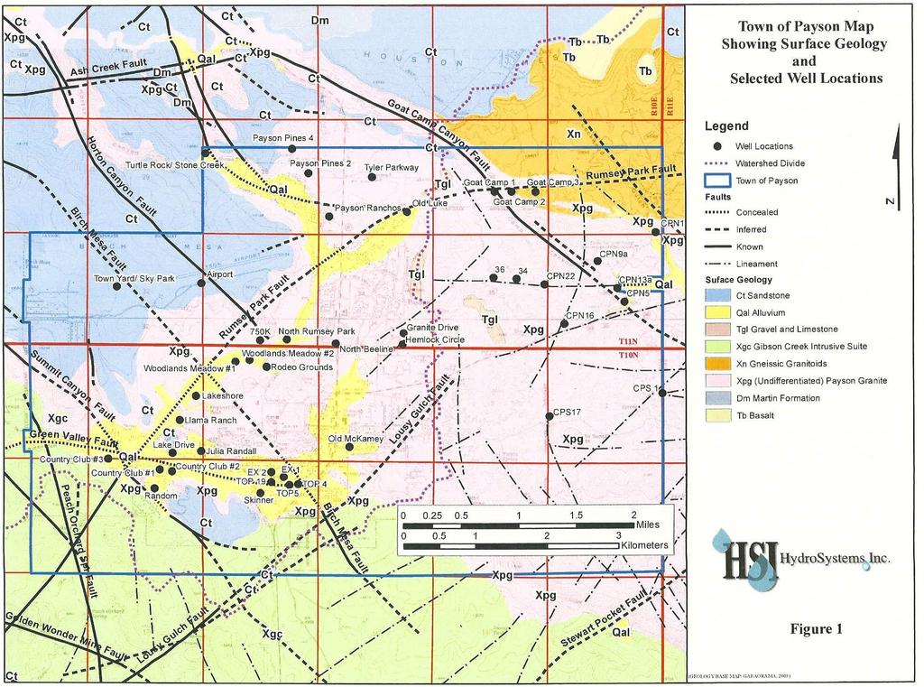
12 Hydrogeologic Framework REGIONAL GEOLOGY Rock Units Age Tectonic Events Gravel, sands, silts Quaternary-Recent None Rim Gravel and Limestone Tertiary-Quaternary Late B. and R. Basalt flows Tertiary (Cenozoic) Late B. and R. Colorado Plateau Section: Limestones, conglomerates, sandstones, shales Felsic to mafic volcanic and intrusive rocks; metasediments, metavolcanics Cambrian-Permian (Paleozoic) Early to Middle Proterozoic ( Ma) (Precambrian) B. and R. Laramide Jurassic Faulting B. and R. Laramide Jurassic Faulting

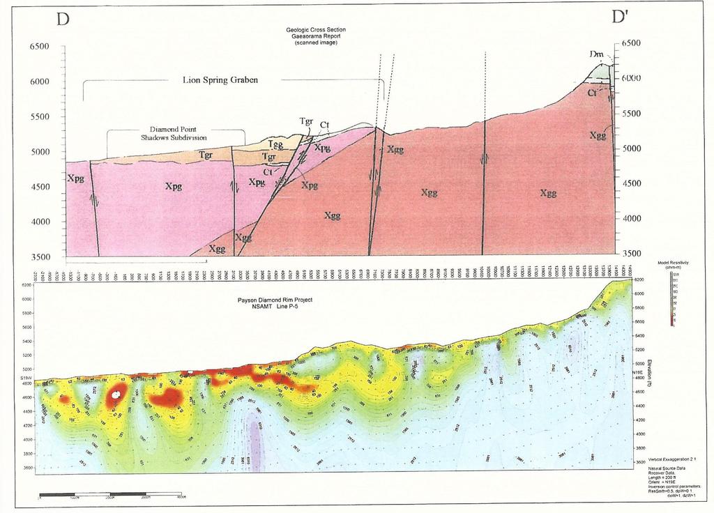
13 Composite, General Stratigraphic Section for the Study Area. Looking west along the Diamond Rim Fault across the northern part of the Verde Graben, west of Payson

14 Geologic Cross-Section Displaying Water Level Elevation From the Mogollon Rim to the East Verde River

15 ARIZONA TECTONIC EVENTS pc FOLDING 1.6 b.y pc RIFTING JURASSIC FAULTING LARAMIDE FOLDING, THRUSTING PLUTONISM CORE COMPLEX MID-MIOCENE FAULTING B AND R FAULTING 1.1 b.y 150 m.y. 65 m.y. 25 m.y. 14 m.y. 6 m.y. TIME ---Summary of the tectonic events in Arizona and their approximate mean time of occurrence. The middle Cenzoic orogeny includes the core complex formation and the detachment-listric faulting.
16
17 Hydrogeologic Framework HYDROGEOLOGY

18 The C-Aquifer, Mogollon Rim North of Payson, Arizona

19 The RMX-Aquifer, Payson Airport Road, Arizona


20 Fractured System of the Payson Granite. Road cut in Payson, Arizona. Weathered Payson Granite. Road cut in Payson, Arizona.
21 Hydrogeochemistry Source Surface Water C.C. Cragin (Blue Ridge) Reservoir SRP Groundwater Capacity: 18.5 Mm 3, ; Runoff snowmelt and rain from the Colorado Plateau. Type: Calcium Bicarbonate; TDS ~ 42 mg/l; ph ~ 7.3; LI ~-1.8 Shallow/Local Aquifer (Payson Granite X Aquifer) Type: Calcium Bicarbonate TDS: mg/l; ph ~ 7.2 Deep/Regional Aquifer (Payson Granite X Aquifer) Type: Calcium-Bicarbonate TDS: mg/l; ph ~ 7.8 Local + Regional Aquifer (Payson X Aquifer) Type: Calcium Bicarbonate TDS ~ 266 mg/l; ph ~ 7.7; Ca ~ 47mg/l; Fe ~0.056 mg/l; As<0.001mg/l Regional X Aquifer (Gibson Creek Batholith) Higher TDS, Na S0 4 (sulphide veins) Blending SW and GW. In the Aquifer (Payson Granite) Geochemical Modeling: Dissolution of CaC03 and CaS04 and minor precipitation of Fe(OH)3.

22 The C.C. Cragin Reservoir Located in the Colorado Plateau, north of Payson, Arizona. It is a unit of the SRP surface water storage system.
23 Water Chemistry Difference Piper Diagram Indicating Water Chemistry Difference Between Regional Groundwater Aquifers and Local Recharge Town of Payson, Arizona

24 Chemical Variability of Spring, Surface and Well Waters Chemical Variability of Spring, Surface and Well Waters as Shown by Stiff Diagrams (Colors indicate regional aquifer contribution and shapes generally vary according to amount of local recharge)

25 Geophysical Studies NSAMT Survey. Zonge Engineering Crew, Payson, Arizona
26
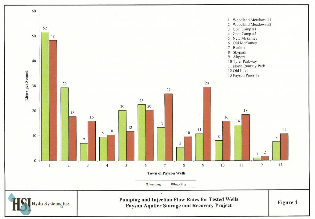
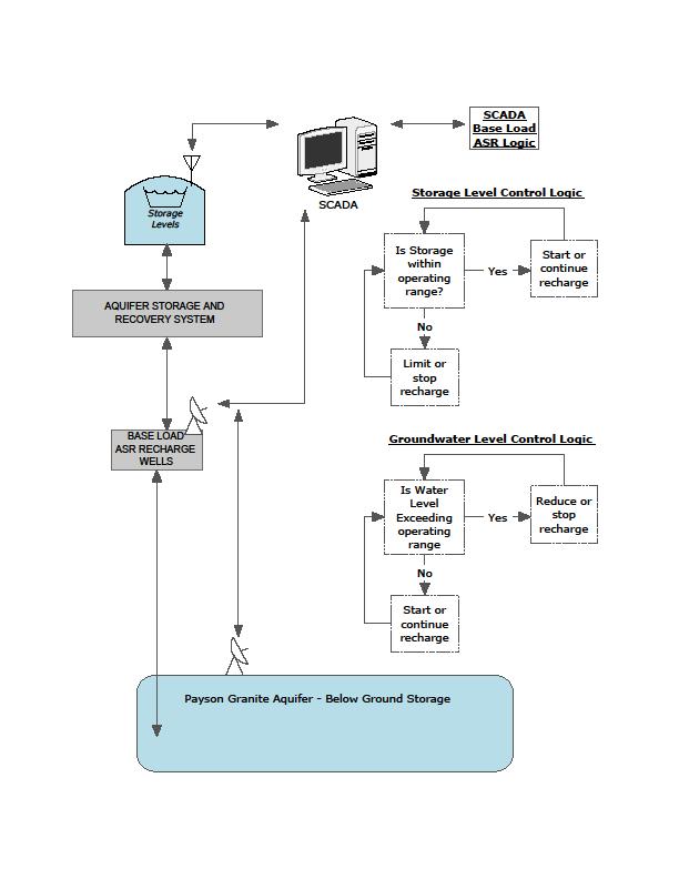
27 ASR Evaluation The Town of Payson ASR System and Operation 2006 Tested 5 existing wells Recharge capacity 81.6 l/s Tested 8 existing wells Recharge capacity: l/s 13 wells recharge capacity: 20,000 m 3 /d ASR Planned Operation Will use excess WTP water after municipal and surface storage demand is met. ASR Well Field: 4 Base Load Wells 20 cm (8 ) steel casing with O.P. Recharge continuously 4 On-Call Wells 25 cm (10 ) steel casing with F.C.V. Recharge on demand only Computerized (SCADA) Fully Automated Recharge Operation With Manual Control Option.
28

29 Town of Payson ASR Well Testing
30
31
 Water Resources Portfolio:")
32 With Renewable Surface Water Use Fully Maximized Via ASR and Conjunctive Use Payson Achieves True Water Resources Sustainability Town of Payson Future ( ) Water Resources Portfolio: Diversified

33 Do ASR Wells Really Work in Granite? The Payson Water Department, in collaboration with HydroSystems Inc., have tested about a dozen wells. It can be done! Payson will be one of the first to use ASR in a fracture granite aquifer. We have proven a recharge capacity of more than 231 l/s or about 20,000 m 3 /d Exceeded project goal by more than 100%
Soils, Hydrogeology, and Aquifer Properties. Philip B. Bedient 2006 Rice University
 Soils, Hydrogeology, and Aquifer Properties Philip B. Bedient 2006 Rice University Charbeneau, 2000. Basin Hydrologic Cycle Global Water Supply Distribution 3% of earth s water is fresh - 97% oceans 1%
Evolution of the conceptual hydrogeologic and ground-water flow model for Las Vegas Valley, Clark County, Nevada
 Evolution of the conceptual hydrogeologic and ground-water flow model for Las Vegas Valley, Clark County, Nevada Geological Society of America Annual Meeting November 14, 2 David J. Donovan Southern Nevada
the Quarrying Industry Dewatering and the Quarrying Industry the Quarrying Industry
 Dewatering and the Quarrying Industry Dewatering and Dewatering and the Quarrying Industry the Quarrying Industry Les Brown Eugene P. Daly John Kelly Objectives 1) To present a summary of water management
A Preliminary Geophysical Reconnaissance Mapping of Emirau Ground Water Resource, Emirau Island, New Ireland Province, PNG
 A Preliminary Geophysical Reconnaissance Mapping of Emirau Ground Water Resource, Emirau Island, New Ireland Province, PNG Geological Survey Division of Mineral Resources Authority (MRA) Papua New Guinea
11/22/2010. Groundwater in Unconsolidated Deposits. Alluvial (fluvial) deposits. - consist of gravel, sand, silt and clay
 deposits. - consist of gravel, sand, silt and clay") Groundwater in Unconsolidated Deposits Alluvial (fluvial) deposits - consist of gravel, sand, silt and clay - laid down by physical processes in rivers and flood plains - major sources for water supplies
Groundwater in Unconsolidated Deposits Alluvial (fluvial) deposits - consist of gravel, sand, silt and clay - laid down by physical processes in rivers and flood plains - major sources for water supplies
ILLINOIS GROUNDWATER - BEDROCK
 ILLINOIS GROUNDWATER - BEDROCK Northern Illinois Fresh Water Water Supply Shallow Bedrock Aquifers < 500 depth Deep Bedrock Aquifers > 500 depth Southern Illinois Saline water Oil Fracking Coal Waste injection
Geology (Mellow) Hike, Santa Lucia Memorial Park February 16, I. Overview of Santa Lucia Range geology and tectonic history
 Hike, Santa Lucia Memorial Park February 16, I. Overview of Santa Lucia Range geology and tectonic history") Geology (Mellow) Hike, Santa Lucia Memorial Park February 16, 2015 I. Overview of Santa Lucia Range geology and tectonic history A. Basement Rocks 1. Salinian Block Rocks Sierra Nevada Type, continental
Geology (Mellow) Hike, Santa Lucia Memorial Park February 16, 2015 I. Overview of Santa Lucia Range geology and tectonic history A. Basement Rocks 1. Salinian Block Rocks Sierra Nevada Type, continental
Result of Field Geological Survey and Ground Truth for the Analysis Date: 2007/7/5 Location (UTM) Elev Geological Unit Point No. NT-02 VSW Index 260,7
 Elev Geological Unit Point No. NT-02 VSW Index 260,7") Date: Point No. 2007/7/5 NT-01 Result of Field Geological Survey and Ground Truth for the Analysis Location (UTM) Topography of granite hill in flat land Lithology: Medium grained hornblende granite. Topography:
Date: Point No. 2007/7/5 NT-01 Result of Field Geological Survey and Ground Truth for the Analysis Location (UTM) Topography of granite hill in flat land Lithology: Medium grained hornblende granite. Topography:
Continental Landscapes
 Continental Landscapes Landscape influenced by tectonics, climate & differential weathering Most landforms developed within the last 2 million years System moves toward an equilibrium Continental Landscapes
Groundwater Replenishment In The Coachella Valley, CA. WESTCAS 2018 Annual Conference June 21, 2018 Zoe Rodriguez del Rey, Water Resources
 Groundwater Replenishment In The Coachella Valley, CA WESTCAS 2018 Annual Conference June 21, 2018 Zoe Rodriguez del Rey, Water Resources Coachella Valley Indio Mecca Palm Springs La Quinta Thermal 2 Coachella
Geothermal Resources Suitability for Desalination in New Mexico
 GEOTHERMAL EXPLORATION, MCGREGOR RANGE, NEW MEXICO Geothermal Resources Suitability for Desalination in New Mexico JAMES C WITCHER WITCHER AND ASSOCIATES LAS CRUCES, NM Witcher CAPACITY FACTORS 100 80
Seismic Data and Drilling in Hancock Co., Kentucky February 21, 2008
 Seismic Data and Drilling in Hancock Co., Kentucky February 21, 2008 J.A. Drahovzal 2/21/08 1 Hancock County (H1) Information Provided at 2/7/08 Meeting Depth of Top (t) and Thickness (th) in feet t Kn
Groundwater Resources of Missouri. Cynthia Brookshire, R. G.
 Groundwater Resources of Missouri Cynthia Brookshire, R. G. GROUNDWATER... Water beneath the Earth s surface within a zone of saturation AQUIFER... A geologic formation or group of formations that are
Mark S. Nordberg Geology and Groundwater Investigations Section North Central Region Office California Department of Water Resources
 Mark S. Nordberg Geology and Groundwater Investigations Section North Central Region Office California Department of Water Resources Ukiah Drought Workshop July 29, 2009 Groundwater 101 Groundwater is
GEOL Introductory Geology: Exploring Planet Earth Fall 2010 Test #2 October 18, 2010
 GEOL 101 - Introductory Geology: Exploring Planet Earth Fall 2010 Test #2 October 18, 2010 Name KEY ID# KEY Multiple choice questions (2 points each). 1. What type of metamorphic rock is formed over large
Ground Water in the Piedmont and Blue Ridge
 engineering earth's development preserving earth's integrity Engineering Earth s Development Preserving Earth s Integrity Ground Water in the Piedmont and Blue Ridge Jim Renner Acknowledgements Contributors:
Tuesday 6 June 2017 Afternoon
 Oxford Cambridge and RSA Tuesday 6 June 2017 Afternoon A2 GCE GEOLOGY F794/01 Environmental Geology *6783378785* Candidates answer on the Question Paper. OCR supplied materials: None Other materials required:
Hydrogeologic Conceptual Models for Regional Flow Systems
 Hydrogeologic Conceptual Models for Regional Flow Systems R.T. Hanson, U.S. Geological Survey One Water Hydrologic Flow Model USGS MODFLOW-OWHM Session 4 Groundwater Subbasin Baseline Historic and Current
LAUREL MARCUS California Land Stewardship Institute OVERVIEW OF GROUNDWATER STUDIES IN THE RUSSIAN RIVER WATERSHED
 LAUREL MARCUS California Land Stewardship Institute OVERVIEW OF GROUNDWATER STUDIES IN THE RUSSIAN RIVER WATERSHED - 60% OF LAND AREA } 20% OF LAND AREA } 20% OF LAND AREA GEOLOGY OF THE RUSSIAN RIVER
Gravel Transport Can Determine Late Flood Tectonics
 Chapter 23 Gravel Transport Can Determine Late Flood Tectonics The locations of all the quartzite gravel in the northwest states and adjacent Canada provide more information about the Flood than just reinforcing
Assessment of Artificial Groundwater Recharge in Some Wadies in UAE by using Isotope Hydrology Techniques
 Assessment of Artificial Groundwater Recharge in Some Wadies in UAE by using Isotope Hydrology Techniques Presented by : Ahmed Saif Al Matri Head, Water Resources Section Ministry of Environment & Water
Hydrogeology and Simulated Effects of Future Water Use and Drought in the North Fork Red River Alluvial Aquifer: Progress Report
 Hydrogeology and Simulated Effects of Future Water Use and Drought in the North Fork Red River Alluvial Aquifer: Progress Report Developed in partnership with the Oklahoma Water Resources Board S. Jerrod
Climate also has a large influence on how local ecosystems have evolved and how we interact with them.
 The Mississippi River in a Changing Climate By Paul Lehman, P.Eng., General Manager Mississippi Valley Conservation (This article originally appeared in the Mississippi Lakes Association s 212 Mississippi
BIG CHINO VALLEY GROUND WATER AS THE SOURCE OF THE VERDE RIVER. Jon R Ford
 BAK626 BIG CHINO VALLEY GROUND WATER AS THE SOURCE OF THE VERDE RIVER Jon R Ford ABSTRACT: Debate continues regarding the source of springs that form the base flow at the headwaters of the Verde River
Lab 9: Petroleum and groundwater
 Geology 101 Name(s): Lab 9: Petroleum and groundwater Petroleum (oil) is a multi-component liquid refined to generate different hydrocarbons, such as heptane (a component of gasoline) and waxes. For the
1.0 Introduction 1.1 Geographic Location 1.2 Topography 1.3 Climate and Rainfall 1.4 Geology and Hydrogeology 1.5 Water Availability 1.
 1.0 1.1 Geographic Location 1.2 Topography 1.3 Climate and Rainfall 1.4 Geology and Hydrogeology 1.5 Water Availability 1.6 Demography 1.0 1.1 Geographic Location St. Lucia forms part of an archipelago
Executive Summary. Water Quantity
 Executive Summary Stakeholders in the Rock-Glade Watershed have taken the initiative to proceed with watershed planning as provided by the State of Washington under the Watershed Management Act (Chapter
Hydrogeology of East-Central Union County, Northeastern New Mexico
 Hydrogeology of East-Central Union County, Northeastern New Mexico Geoffrey Rawling April 2013 New Mexico Bureau of Geology & Mineral Resources 1 What are the important hydrogeologic issues in Union County?
Airborne Geophysics to Map Groundwater. Bill Brown
 Airborne Geophysics to Map Groundwater Bill Brown bb@skytem.com A 6 borehole represents 1 millionth of an acre Aquifer Materials An aquifer is an underground layer of water bearing permeable rock, rock
URBAN HYDROLOGY: WATER IN THE CITY OF TSHWANE Plant Sciences Auditorium, University of Pretoria January 2014 URBAN HYDROGEOLOGY
 URBAN HYDROLOGY: WATER IN THE CITY OF TSHWANE Plant Sciences Auditorium, University of Pretoria 23 24 January 2014 URBAN HYDROGEOLOGY MATTHYS A. DIPPENAAR DEPARTMENT GEOLOGY, UNIVERSITY OF PRETORIA HYDROGEOLOGY
Napa Valley Groundwater Sustainability: A Basin Analysis Report for the Napa Valley Subbasin
 Napa Valley Groundwater Sustainability: A Basin Analysis Report for the Napa Valley Subbasin December 13, 2016 Napa County Board of Supervisors By Vicki Kretsinger Grabert and Reid Bryson Basin Analysis
Section 5. Rock Units and Your Community. What Do You See? Think About It. Investigate. Learning Outcomes
 Chapter 3 Minerals, Rocks, and Structures Section 5 Rock Units and Your Community What Do You See? Learning Outcomes In this section, you will Recognize that rocks are arranged in Earth s crust as well-defined
Daniel Koning, Peggy Johnson, and John Hawley. New Mexico Bureau of Geology and Mineral Resources
 Daniel Koning, Peggy Johnson, and John Hawley Daniel Koning 1, Gary Smith 2, and Adam Read 1 1 New Mexico Bureau of Geology and Mineral Resources 2 University of New Mexico Santa Fe Group Definition (Spiegel
The Nubian Sandstone Aquifer System. Martina Müller Claudia Dengler Felix Leicht
 The Nubian Sandstone Aquifer System Martina Müller Claudia Dengler Felix Leicht Geography Transboundary groundwater system beneath the north-eastern Sahara total extension of over 2.2 Mio km² Shared between
PRECAMBRIAN CRYSTALLINE AQUIFER (METAMORPHIC ROCKS)
") HAYWARD QUADRANGLE: Groundwater Production by Aquifer In the 56-square-mile area of the Hayward Quadrangle, groundwater is produced from metamorphic crystalline rocks of the Precambrian basement (in the
HAYWARD QUADRANGLE: Groundwater Production by Aquifer In the 56-square-mile area of the Hayward Quadrangle, groundwater is produced from metamorphic crystalline rocks of the Precambrian basement (in the
Geology 12 FINAL EXAM PREP. Possible Written Response Exam Questions
 Geology 12 FINAL EXAM PREP Possible Written Response Exam Questions Use this study guide to prepare for the written response portion of the final exam. Name FINAL EXAM - POSSIBLE WRITTEN RESPONSE QUESTIONS
Mineral activities within Rich County, Utah
 Natural Resources and Environmental Issues Volume 14 Bear Lake Basin Article 10 1-1-2007 Mineral activities within Rich County, Utah Patsy Palacios SJ & Jessie E Quinney Natural Resources Research Library,
APPENDIX 3B OCCURRENCE OF SIGNIFICANT RIVER ALLUVIUM AQUIFERS IN THE PLATEAU REGION
 Plateau Region Water Plan January 2011 APPENDIX 3B OCCURRENCE OF SIGNIFICANT RIVER ALLUVIUM AQUIFERS IN THE PLATEAU REGION Occurrence of Significant River Alluvium Aquifers in the Plateau Region Prepared
Student Name: 1) 2) GeoLogic Mapping. UNL - May 16, Event supervisor: Enrica Quartini
 2) GeoLogic Mapping. UNL - May 16, Event supervisor: Enrica Quartini") School Name: Team # Student Name: 1) 2) GeoLogic Mapping National Science Olympiad Tournament UNL - May 16, 2015 Event supervisor: Enrica Quartini staff.aist.go.jp Ø All answers must be reported clearly
School Name: Team # Student Name: 1) 2) GeoLogic Mapping National Science Olympiad Tournament UNL - May 16, 2015 Event supervisor: Enrica Quartini staff.aist.go.jp Ø All answers must be reported clearly
CARTER METALLURGICAL COAL PROJECT. Endurance Gold Corporation (EDG)
") CARTER METALLURGICAL COAL PROJECT McDOWELL COUNTY, WEST VIRGINIA Endurance Gold Corporation (EDG) Endurance Resources Inc. (ERI) Prepared by: Duncan McIvor, President and CEO Endurance Gold Corporation
CARTER METALLURGICAL COAL PROJECT McDOWELL COUNTY, WEST VIRGINIA Endurance Gold Corporation (EDG) Endurance Resources Inc. (ERI) Prepared by: Duncan McIvor, President and CEO Endurance Gold Corporation
GEO 303. Introduction to Geology LAB FINAL EXAM
 Name Lab section: Day Hour TA GEO 303 Introduction to Geology LAB FINAL EXAM Spring, 1999 100 points 2 INSTRUCTION: This multiple-choice, machine-graded exam consists of 100 questions, each worth 1 point.
PRELIMINARY. Select Geophysical Methods and Groundwater Modeling: Examples from USGS studies. Claudia Faunt and a cast of others
 Select Geophysical Methods and Groundwater Modeling: Examples from USGS studies Claudia Faunt and a cast of others Current Preliminary Studies Stanford Water in the West Groundwater Data Workshop Series:
CENTRAL UTAH: A NEW OIL AND GAS PROVINCE
 CENTRAL UTAH: A NEW OIL AND GAS PROVINCE By Floyd and Mike By: Floyd Moulton and Mike Pinnell Wolverine Discovery Eastern Limit of Thrusting Presentation Outline Regional Setting Paleozoic Source Rock
DATA ACQUISITION METHODS FOR GROUNDWATER INVESTIGATION AND THE SITING OF WATER SUPPLY WELLS
 DATA ACQUISITION METHODS FOR GROUNDWATER INVESTIGATION AND THE SITING OF WATER SUPPLY WELLS M.B.J. Foster Tetra Tech EM Inc., San Francisco, CA, USA Keywords: Groundwater, water wells, drilled wells, geophysical
This paper summarizes what we know about a fascinating, previously unknown hi T geothermal system in SE Idaho
 This paper summarizes what we know about a fascinating, previously unknown hi T geothermal system in SE Idaho that came to light during the compilation of geothermally relevant data for the DOE s National
Geologic Considerations of Shallow SAGD Caprock; Seal Capacity, Seal Geometry and Seal Integrity, Athabasca Oilsands, Alberta Canada
 Geologic Considerations of Shallow SAGD Caprock; Seal Capacity, Seal Geometry and Seal Integrity, Athabasca Oilsands, Alberta Canada Gordon T. Stabb, Michael Webb Durando Resources Corp, Suncor Energy
Overview of Indonesian Geothermal System
 Overview of Indonesian Geothermal System The Resources Beyond High Enthalpy Magmatic/Volcanic Systems By Dr.Eng. Suryantini ITB 4/3/2017 1 Outline Current Condition of Indonesian Geothermal Resources and
CEE 437 Lecture 10 Rock Classification. Thomas Doe
 CEE 437 Lecture 10 Rock Classification Thomas Doe Igneous Origins Intrusive Batholithic or plutonic: phaneritic Dikes or sills that chill rapidly: aphanitic Extrusive deposition as melt (lava) pyroclastic
ENGINEER S CERTIFICATION OF FAULT AREA DEMONSTRATION (40 CFR )
") PLATTE RIVER POWER AUTHORITY RAWHIDE ENERGY STATION BOTTOM ASH TRANSFER (BAT) IMPOUNDMENTS LARIMER COUNTY, CO ENGINEER S CERTIFICATION OF FAULT AREA DEMONSTRATION (40 CFR 257.62) FOR COAL COMBUSTION RESIDUALS
PLATTE RIVER POWER AUTHORITY RAWHIDE ENERGY STATION BOTTOM ASH TRANSFER (BAT) IMPOUNDMENTS LARIMER COUNTY, CO ENGINEER S CERTIFICATION OF FAULT AREA DEMONSTRATION (40 CFR 257.62) FOR COAL COMBUSTION RESIDUALS
Geology 15 West Valley College. Exam IV: Sierra Nevada
 Geology 15 West Valley College Name Exam IV: Sierra Nevada 1) On the diagram above, where is the Arc- Trench Gap? a. 1 and 3 c. 7 and 8 d. 6 e. 5 and 10 2) On the diagram above, where is the subduction
Geologic History of Texas: The Making of Texas Over 1.5 Billion Years
 # 4 Geologic History of Texas: The Making of Texas Over 1.5 Billion Years Dr. Richard Kyle March 24, 2000 Produced by and for Hot Science - Cool Talks by the Environmental Science Institute. We request
2. PHYSICAL SETTING FINAL GROUNDWATER MANAGEMENT PLAN. 2.1 Topography. 2.2 Climate
 FINAL GROUNDWATER MANAGEMENT PLAN 2. PHYSICAL SETTING Lassen County is a topographically diverse area at the confluence of the Cascade Range, Modoc Plateau, Sierra Nevada and Basin and Range geologic provinces.
GROUNDWATER OCCURRENCE IN KENYA
 GROUNDWATER OCCURRENCE IN KENYA Steven Okoth Owuor Ministry of Water and Sanitation Sunday, January 20, 2019 1 Geography INTRODUCTION The Republic of Kenya is located in East Africa The total area of the
Multimethod Geophysical Characterization of Fault Systems for Environmental Planning
 Multimethod Geophysical Characterization of Fault Systems for Environmental Planning John A. Mundell and Ryan P. Brumbaugh, Mundell & Associates, Inc. Brian Ham and Ric Federico, EnSafe Inc. Talk Outline
Tucson Geologic History: Cenozoic ( Ma (million years ago)) Dr. Jan C. Rasmussen
) Dr. Jan C. Rasmussen") Tucson Geologic History: Cenozoic (65.5 0 Ma (million years ago)) Dr. Jan C. Rasmussen www.janrasmussen.com Temp. & Geologic Time Scale 4.6 Ga Tertiary 65-0 Ma Orogenies (mountain building) Cenozoic Formations
Tucson Geologic History: Cenozoic (65.5 0 Ma (million years ago)) Dr. Jan C. Rasmussen www.janrasmussen.com Temp. & Geologic Time Scale 4.6 Ga Tertiary 65-0 Ma Orogenies (mountain building) Cenozoic Formations
RESISTIVITY IMAGING IN EASTERN NEVADA USING THE AUDIOMAGNETOTELLURIC METHOD FOR HYDROGEOLOGIC FRAMEWORK STUDIES. Abstract.
 RESISTIVITY IMAGING IN EASTERN NEVADA USING THE AUDIOMAGNETOTELLURIC METHOD FOR HYDROGEOLOGIC FRAMEWORK STUDIES Darcy K. McPhee, U.S. Geological Survey, Menlo Park, CA Louise Pellerin, Green Engineering,
Sacramento Valley Groundwater Basin, Sutter Subbasin
 Sacramento Valley Groundwater Basin, Sutter Subbasin Groundwater Basin Number: 5-21.62 County: Sutter Surface Area: 234,400 acres (366 square miles) Boundaries and Hydrology The Sutter Subbasin lies in
M Z I M K H U L U
 Table 4.52 Yield information for the proposed dams in the Middle South Coast Region. Impoundment River Capacity (million m 3 ) Yield (million m 3 /year) Stochastic Yield (million m 3 /year) Historical
Overview of the Seismic Source Characterization for the Palo Verde Nuclear Generating Station
 Overview of the Seismic Source Characterization for the Palo Verde Nuclear Generating Station Scott Lindvall SSC TI Team Lead Palo Verde SSC SSHAC Level 3 Project Tuesday, March 19, 2013 1 Questions from
EVALUATION OF AQUIFER CHARACTERISTICS FOR SELECTED NEW METHOD OF THE UM RUWABA FORMATION: NORTH KORDOFAN STATE, SUDAN
 EVALUATION OF AQUIFER CHARACTERISTICS FOR SELECTED NEW METHOD OF THE UM RUWABA FORMATION: NORTH KORDOFAN STATE, SUDAN ELHAGA.B *1; ELZIENS.M*2 ANDLISSANN.H*3 *1Department of C i v i l E n g i n e e r i
NOA ASSESSMENT HARRIS QUARRY MENDOCINO COUNTY, CALIFORNIA TABLE OF CONTENTS
 NOA ASSESSMENT HARRIS QUARRY MENDOCINO COUNTY, CALIFORNIA TABLE OF CONTENTS Introduction... 1 Scope of Services... 1 Project Location and Description... 1 Geologic Setting... 1 Regional Geology... 1 Site
Susquehanna River Basin A Research Community Hydrologic Observatory. NSF-Funded Infrastructure Proposal in Support of River Basin Hydrologic Sciences
 Susquehanna River Basin A Research Community Hydrologic Observatory NSF-Funded Infrastructure Proposal in Support of River Basin Hydrologic Sciences Fundamental Problem: How Do Humans and Climate Impact
The Owens River Valley: A Dry Lake and a Water Controversy. the ongoing battle between the Los Angeles Department of Water and Power and the
 Balzano 1 Andrea Balzano G188 Final Essay 12 June 2012 Abstract The Owens River Valley: A Dry Lake and a Water Controversy The Owens River Valley is a prime example of the water issues California faces
Prepared By: John Blair Sean Donahue Celeste Hoffman Kimberly Klinkers Megan Slater
 Prepared By: John Blair Sean Donahue Celeste Hoffman Kimberly Klinkers Megan Slater Green River Basin Location Green River Basin Stratigraphic Correlation Chart showing Study Map Units Sample of Existing
Hydrogeology of the San Agustin Plains
 Hydrogeology of the San Agustin Plains Alex Rinehart, Daniel Koning and Stacy Timmons New Mexico Bureau of Geology New Mexico Tech 16 August 2017 62nd New Mexico Water Conference Acknowledgments Community
WWDC Green River Basin Plan II, Groundwater Study (Level I) WSGS USGS WRDS October 23, 2008 Green River Basin (GRB) Basin Advisory Group
 WSGS USGS WRDS October 23, 2008 Green River Basin (GRB) Basin Advisory Group") WWDC Green River Basin Plan II, Groundwater Study (Level I) WSGS USGS WRDS 2007-20092009 October 23, 2008 Green River Basin (GRB) Basin Advisory Group (BAG) Western Wyoming Community College, Rock Springs,
WWDC Green River Basin Plan II, Groundwater Study (Level I) WSGS USGS WRDS 2007-20092009 October 23, 2008 Green River Basin (GRB) Basin Advisory Group (BAG) Western Wyoming Community College, Rock Springs,
Late Tertiary Volcanism. North Washington. Other Andesite Volcanoes. Southern Washington. High Cascades. High Cascades. Mid-Miocene Miocene to present
 Miocene to Present Late Tertiary Volcanism Mid-Miocene Miocene to present Reading: DNAG volume G3, Ch. 7 High Cascade Range Columbia River Snake River Plain Basin and Range Southwestern California Sierra
WESTCARB Phase I Results Review
 WESTCARB Phase I Results Review Arizona Geologic Characterization Errol Montgomery Principal Errol L. Montgomery & Associates (520) 881-4912 emontgomery@elmontgomery.com November 9, 2005 Site Characterization
The Capitan Aquifer - Ellenburger Production Wells Geothermal Engine Source?
 GEOTHERMAL ENERGY UTILIZATION ASSOCIATED WITH OIL & GAS DEVELOPMENT June 17-18, 2008 Southern Methodist University Dallas, Texas The Capitan Aquifer - Ellenburger Production Wells Geothermal Engine Source?
Characterizing Seal Bypass Systems at the Rock Springs Uplift, Southwest Wyoming, Using Seismic Attribute Analysis*
 Characterizing Seal Bypass Systems at the Rock Springs Uplift, Southwest Wyoming, Using Seismic Attribute Analysis* Yuri Ganshin 1 and Fred McLaughlin 1 Search and Discovery Article #80483 (2015)** Posted
Napa County Comprehensive Groundwater Monitoring Program 2015 Annual Report and CASGEM Update
 Napa County Comprehensive Groundwater Monitoring Program 2015 Annual Report and CASGEM Update April 21, 2016 Watershed Information & Conservation Council By Vicki Kretsinger Grabert Overview Evolving groundwater
OIL AND GAS PLAYS OF THE MICHIGAN BASIN, SOUTHERN ONTARIO. Terry Carter, Consulting Geologist London, Ontario
 OIL AND GAS PLAYS OF THE MICHIGAN BASIN, SOUTHERN ONTARIO Terry Carter, Consulting Geologist London, Ontario 1 Ontario Petroleum Industries Oil and Natural Gas 1250 oil wells, 1200 gas wells, annual production
Wisconsin s Hydrogeology: an overview
 2012 Soil and Water Conservation Society Conference Stevens Point, WI Feb 9, 2012 Wisconsin s Hydrogeology: an overview Ken Bradbury Wisconsin Geological and Natural History Survey University of Wisconsin-Extension
GPR AS A COST EFFECTIVE BEDROCK MAPPING TOOL FOR LARGE AREAS. Abstract
 GPR AS A COST EFFECTIVE BEDROCK MAPPING TOOL FOR LARGE AREAS Dr. Jutta L. Hager, Hager GeoScience, Inc., Waltham, MA Mario Carnevale, Hager GeoScience, Inc., Waltham, MA Abstract Hager GeoScience, Inc.
Earth History Exam. The remains of an early dinosaur could be found at reference point A. A B. B C. C D. D. page 1
 Name: Date: 1. Base your answer(s) to the following question(s) on the Earth Science Reference Tables and your knowledge of Earth science. The accompanying cross section shows undisturbed sedimentary bedrock.
Portland Water Bureau. Preparing Portland s Water Supply for The Big One. July 11, Tim Collins, P.E., G.E.
 Portland Water Bureau Preparing Portland s Water Supply for The Big One July 11, 2018 Tim Collins, P.E., G.E. Presentation Outline Portland water system overview Pacific Northwest seismic hazards Building
Bryce Canyon. Bryce Zion
 Bryce Canyon Located ~50 mi NE of Zion in southern Utah On Paunsaugunt Plateau: Wetter and Colder than Zion Bounded by Sevier Fault to west and Paunsaugunt Fault to east Rocks are ~100 Ma older than at
Water Resources of Saudi Arabia
 Water Resources of Saudi Arabia Resources of Saudi Arabia 1 Water Resources of Saudi Arabia Water Supply in KSA Surface water (48-10%) Groundwater (49-80% @ 70m- 1000m depth) Desalinated water (3-6%) Reclaimed
Atlantic Rim Coalbed Methane Play: The Newest SuccessfulCBM Play in the Rockies
 Atlantic Rim Coalbed Methane Play: The Newest SuccessfulCBM Play in the Rockies Robert A. Lamarre Lamarre Geological, Denver, Colorado Stephen K. Ruhl Anadarko Petroleum Corporation, The Woodlands, Texas
Objective 3: Earth and Space Systems
 Name Class Period: Objective 3: Earth and Space Systems 1. The diagram above shows the orbit of the moon around Earth. At which point in the moon s orbit will a person standing on Earth see a waxing crescent
Mesozoic Earth History
 Mesozoic Earth History The Mesozoic Era 251-66 MYA Breakup of Pangea Changes in air and oceanic currents Evolution of new terrestrial and marine life Opening of the Atlantic Ocean Basin Rocky Mountains
Finding Large Capacity Groundwater Supplies for Irrigation
 Finding Large Capacity Groundwater Supplies for Irrigation December 14, 2012 Presented by: Michael L. Chapman, Jr., PG Irrigation Well Site Evaluation Background Investigation Identify Hydrogeologic Conditions
There are numerous seams on the surface of the Earth
 Plate Tectonics and Continental Drift There are numerous seams on the surface of the Earth Questions and Topics 1. What are the theories of Plate Tectonics and Continental Drift? 2. What is the evidence
Ingle Creek Placer Mine
 Location and Accessibility The Ingle Creek claims lie within the Fortymile mining district of east central Alaska. There are 3 40-acre state claims located 4 miles west of Chicken. Ingle Creek is a 2 mile
FRACTURE TRACES AND PRODUCTIVITY OF MUNICIPAL WELLS IN THE MADISON LIMESTONE, RAPID CITY, SOUTH DAKOTA
 Proceedings of the South Dakota Academy of Science, Vol. 87 (2008) 261 FRACTURE TRACES AND PRODUCTIVITY OF MUNICIPAL WELLS IN THE MADISON LIMESTONE, RAPID CITY, SOUTH DAKOTA Perry H. Rahn Department of
Information Pamphlet 8 WATER LEVELS IN THE UPPER WEST BENCH ALLUVIAL AQUIFER, RED LODGE, MONTANA
 Ground Water Assessment Program Information Pamphlet 8 WATER LEVELS IN THE UPPER WEST BENCH ALLUVIAL AQUIFER, RED LODGE, MONTANA Camela Carstarphen, Thomas Patton, and John I. LaFave View of Remington
GEOLOGY GL1 Foundation Unit
 Candidate Name Centre Number Candidate Number 2 General Certificate of Education Advanced Subsidiary/Advanced 451/01 GEOLOGY GL1 Foundation Unit P.M. THURSDAY, 10 January 2008 (1 hour) Examiner Question
WEALTH MINERALS LTD. Mackenzie Gold Project
 WEALTH MINERALS LTD. Mackenzie Gold Project the Search for a Sediment Hosted Vein Deposit Presented by Paul Klipfel Mineral ineral Resource Services ervices Inc. Mackenzie Misinchinka Range Property Location
Igneous Rocks. Sedimentary Rocks
 Earth Sciences 083F Plate Tectonics Exercises Plate tectonics is a model for the dynamic behaviour of Earth s lithosphere. Outlining stable areas of lithosphere are narrow zones (plate boundaries) in which
FINAL EXAM Crustal Deformation CONVERGE DIVERGENT PLATES MANTLE PLUMES FLUX BASALTIC GRANITIC
 Crustal Deformation Reading: Chapter 10 Pages 283-294 FINAL EXAM 8 to 10 AM, THURSDAY DEC. 6 HERE: Natural Science 101 BRING A SCAN TRON TURN IN YOUR REVIEW QUESTIONS BEFORE THE TEST, PICK UP WHEN YOU
Module 10: Resources and Virginia Geology Topic 4 Content: Virginia Geology Notes
 Virginia is composed of a very diverse landscape that extends from the beaches and barrier islands all of the way to the highly elevated Appalachian Plateau. Geologists have discovered ancient shallow
Basin & Range / Mojave Desert
 Basin & Range / Mojave Desert Basin & Range vs. Great Basin 1 2/20/2016 An overview of the last horst Basin and Range / Mojave Desert Summary: Granitic, volcanic, marine sedimentary, non marine sedimentary,
BACKGROUND, HISTORY AND STATUS OF GEOTHERMAL USE IN BEIJING
 Presented at the Workshop for Decision Makers on Direct Heating Use of Geothermal Resources in Asia, organized by UNU-GTP, TBLRREM and TBGMED, in Tianjin, China, 11-18 May, 2008. GEOTHERMAL TRAINING PROGRAMME
Geologic Trips San Francisco and the Bay Area
 Excerpt from Geologic Trips San Francisco and the Bay Area by Ted Konigsmark ISBN 0-9661316-4-9 GeoPress All rights reserved. No part of this book may be reproduced without written permission in writing,
A multitechnique approach to the dynamics of thermal waters ascribed to a granitic hard rock environment (Serra da Estrela, Central Portugal)
") A multitechnique approach to the dynamics of thermal waters ascribed to a granitic hard rock environment (Serra da Estrela, Central Portugal) J. M. Marques 1, P. M. Carreira 2, J. Espinha Marques 3, H.
A multitechnique approach to the dynamics of thermal waters ascribed to a granitic hard rock environment (Serra da Estrela, Central Portugal) J. M. Marques 1, P. M. Carreira 2, J. Espinha Marques 3, H.
GEOLOGIC MAPS AND GEOLOGIC STRUCTURES A TEXAS EXAMPLE
 GEOLOGIC MAPS AND GEOLOGIC STRUCTURES A TEXAS EXAMPLE Roger Steinberg Assistant Professor of Geology Del Mar College 101 Baldwin Corpus Christi, TX 78404 361-698-1665 rsteinb@delmar.edu For the maps accompanying
Virginia T. McLemore, New Mexico Bureau of Geology and Mineral Resources, New Mexico Institute of Mining and Technology, Socorro, NM 87801,
 Virginia T. McLemore, New Mexico Bureau of Geology and Mineral Resources, New Mexico Institute of Mining and Technology, Socorro, NM 87801, ginger@gis.nmt.edu U2011, Casper, Wy September 20, 2011 Acknowledgments
Questions and Topics
 Plate Tectonics and Continental Drift Questions and Topics 1. What are the theories of Plate Tectonics and Continental Drift? 2. What is the evidence that Continents move? 3. What are the forces that
Mackenzie Delta: Fresh Look At An Emerging Basinpart 1
 Mackenzie Delta: Fresh Look At An Emerging Basinpart 1 ABSTRACT Introduction Christopher L. Bergquist*, Peter P. Graham*, Keith R. Rawlinson and Dennis H. Johnston Devon Canada, 301 400-3rd Avenue SW,
Groundwater Resources of the Las Cruces/Doña Ana County Region
 Groundwater Resources of the Las Cruces/Doña Ana County Region Presentation to Lower Rio Grande Water Users Organization Water Symposium June 6, 2007 Las Cruces, NM by Bobby J. Creel, PhD New Mexico Water