CENTRAL UTAH: A NEW OIL AND GAS PROVINCE
|
|
|
- Grant Chapman
- 6 years ago
- Views:
Transcription


1 CENTRAL UTAH: A NEW OIL AND GAS PROVINCE
2 By Floyd and Mike By: Floyd Moulton and Mike Pinnell
3 Wolverine Discovery Eastern Limit of Thrusting
4 Presentation Outline Regional Setting Paleozoic Source Rock Enigmas Reservoir Rocks Seal: Is the Arapien the One and Only Cross Sections Timing of Critical Events How Many Prospects Are There? Where Do We Go From Here?
5 Presentation Outline Regional Setting Paleozoic Source Rock Enigmas Reservoir Rocks Seal: Is the Arapien the One and Only Cross Sections Timing of Critical Events How Many Prospects Are There? Where Do We Go From Here?

6 Thrust and Fold Belt of Western North America
7

8

9
10 Presentation Outline Regional Setting Paleozoic Source Rock Enigmas Reservoir Rocks Seal: Is the Arapien the One and Only Cross Sections Timing of Critical Events How Many Prospects Are There Where Do We Go From Here?
11 Source Rock Enigma 1: Why Is There No Paleozoic Sourcing in the Wyoming Thrust Fields?
12 Source Rock Enigma 2: Which Paleozoic Formations are the Real Utah Source Rocks?
13 We Will Watch Wolverine and the State of Utah Arm Wrestle Over this Important Matter
14 Presentation Outline Regional Setting Paleozoic Source Rock Enigmas Reservoir Rocks Seal: Is the Arapien the One and Only Timing of Critical Events Cross Sections How Many Prospects Are There? Where Do We Go From Here?

15 Navajo Sandstone Twin Creek Limestone Jurassic Reservoir Rock: Navajo Sandstone

16 Fractured Jurassic Reservoir Rock: Twin Creek Limestone
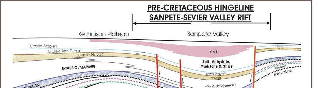
 Jurassic Seal: Arapien Shale, Siltstone and")
17 ARAPIEN SHALE Covenant Field Discovery and Producing Area for Several Wells 18 Wheeler for Scale 10,000 barrel tanks WOLVERINE TANK FARM AND OFF-LOADING FACILITY (UNDER CONSTRUCTION) Jurassic Seal: Arapien Shale, Siltstone and Evaporites


18 2,000-6,000 feet thick SEALING ROCKS Ankareh Formation Woodside Shale Manning Canyon Shale 900 feet thick 1,000 feet thick 1,000 feet thick
19 Twin Creek Limestone 1,200-1,500 Navajo Sandstone Thaynes Limestone 1,200 Phosphoria equivalent carbonates, 800 Diamond Creek Sandstone 3,000 Mississippian and Devonian carbonates ( like Canadian Thrust Salient production) RESERVOIR ROCK UP TO 7,000 OF RESERVOIR ROCK
20 Presentation Outline Regional Setting Paleozoic Source Rock Enigmas Reservoir Rocks Seal: Is the Arapien the One and Only Timing of Critical Events Cross Sections How Many Prospects Are There? Where Do We Go From Here?

21 WEST EAST


22 Thrust Belt Production, Southern Portion, Wyoming Salient Salt Lake City Uinta Mountains Strawberry Reservoir 150 Miles of Prospects (Most Active Area to Date) Wolverine Discovery BASE MAP USED IN THE REST OF THE PRESENTATION


23 Emery High: Pennsylvanian Uplift (Permian on Mississippian)


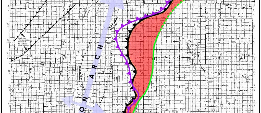
24 Gunnison Arch


25 Gunnison Arch Sanpete-Sevier Rift D U Ancient Ephraim Fault D U


26 D U Gunnison Arch Sanpete-Sevier Rift Gunnison Thrust (trace of the leading edge of Navajo #2, 2,000 feet below production at Covenant Field) D U


27 D U Gunnison Arch Sanpete-Sevier Rift Gunnison Thrust Back Limb Thrust (Covenant Field Navajo #1 producing zone, 2,000 feet above Navajo #2) D U
28 Presentation Outline Regional Setting Paleozoic Source Rock Enigmas Reservoir Rocks Seal: Is the Arapien the One and Only Timing of Critical Events Cross Sections How Many Prospects Are There? Where Do We Go From Here?


29 D U A A D U


30 A A Geology by Floyd Moulton

31 A A F F
32


33 Probable 11,000 Navajo Test Probable 15,000 Navajo Test
34 Presentation Outline Regional Setting Paleozoic Source Rock Enigmas Reservoir Rocks Seal: Is the Arapien the One and Only Timing of Critical Events Cross Sections How Many Prospects Are There? Where Do We Go From Here?
35 Scale Comparison to Wyoming Thrust Belt Salient Production Major Fields in Wyoming Thrust Belt Salient
36 Presentation Outline Regional Setting Paleozoic Source Rock Enigmas Reservoir Rocks Seal: Is the Arapien the One and Only Timing of Critical Events Cross Sections How Many Prospects Are There? Where Do We Go From Here?
37 Some analysts say the Rocky Mountains already have been picked clean for major oil and gas deposits. Finding oil in the Utah Thrust Belt will be like finding a wallet on a busy busy subway car after the cleaners move through it possible, but unlikely Fadel Gheit, senior oil analyst at Oppenheimer & Co. Deseret Morning News, September 22, 2005
38 Some analysts say the Rocky Mountains already have been picked clean for major oil and gas deposits. Finding oil in the Utah Thrust Belt will be like finding a wallet on a busy busy subway car after the cleaners move through it possible, but unlikely Fadel Gheit, senior oil analyst at Oppenheimer & Co. Deseret Morning News, September 22, 2005 It is time to prove the experts are wrong!

39 THANKS TO: AAPG, INTERNATIONAL PETROLEUM, LLC AND PIONEER OIL AND GAS
A publication of the. W. Kenneth Hamblin
 A publication of the Department of Geology Brigharn Young University Provo, Utah 84602 Editors W. Kenneth Hamblin Cynthia M. Gardner Brigham Young University Geology Studies is published semiannually by
Structural Geology of the Mountains
 Structural Geology of the Mountains Clinton R. Tippett Shell Canada Limited, Calgary, Alberta clinton.tippett@shell.ca INTRODUCTION The Southern Rocky Mountains of Canada (Figure 1) are made up of several
EAS 233 Geologic Structures and Maps Winter Miscellaneous practice map exercises. 1. Fault and separation:
 Miscellaneous practice map exercises 1. Fault and separation: With respect to Map 1, what are (a) the orientation of the fault, and (b) the orientation of bedding in the units cut by the fault. (c) Mark
In Development. Central Utah-Nevada Deep Plays Project. ArcGIS Maps & Database, Shale & Oil Analysis, and Basin Evolution
 In Development Principal Investigators: Rasoul Sorkhabi, Ph.D. Research Professor Email: rsorkhabi@egi.utah.edu Greg Nash, Ph.D. Research Associate Professor Email: gnash@egi.utah.edu Sponsor Cost $57k
CH EN 6171 Field Study (Credit or Non-Credit)
") CH EN 6171 Field Study (Credit or Non-Credit) Overview The Department of Chemical Engineering and the Energy & Geoscience Institute (EGI) at the University are offering an eleven-day field program exposing
CH EN 6171 Field Study (Credit or Non-Credit) Overview The Department of Chemical Engineering and the Energy & Geoscience Institute (EGI) at the University are offering an eleven-day field program exposing
Executive Summary Geologic Assessment of Undiscovered Oil and Gas Resources of the Eastern Great Basin Province, Nevada, Utah, Idaho, and Arizona
 Chapter 1 Executive Summary Geologic Assessment of Undiscovered Oil and Gas Resources of the Eastern Great Basin Province, Nevada, Utah, Idaho, and Arizona By U.S. Geological Survey Eastern Great Basin
By Steven Schamel 1. Search and Discovery Article # (2007 Posted September 13, Abstract
 AV Utah Shale Gas: A Developing Resource Play* By Steven Schamel 1 Search and Discovery Article #110067 (2007 Posted September 13, 2008 *Prepared for presentation at AAPG Annual Convention, San Antonio,
Addendum to November 2009 Vantage EA
 Addendum to November 2009 Vantage EA Introduction This document includes additional information, supplemental to that already provided within the Vantage Energy Uintah LLC Ashley National Forest Oil and
Farnham Dome and Grassy Trails Fields, Utah
 Farnham Dome and Grassy Trails Fields, Utah CO 2 accumulation sources and migration paths Matthew Merrill 1, Andrew Hunt 2 1 U.S. Geological Survey, Reston, VA USA 2 U.S. Geological Survey, Lakewood, CO
Mesozoic Earth History
 Mesozoic Earth History The Mesozoic Era 251-66 MYA Breakup of Pangea Changes in air and oceanic currents Evolution of new terrestrial and marine life Opening of the Atlantic Ocean Basin Rocky Mountains
Search and Discovery Article #10532 (2013)** Posted October 21, Abstract
** Posted October 21, Abstract") Utilizing the Delta Log R Method for Determining Total Organic Carbon of the Niobrara Formation, B Bench, Denver-Julesburg Basin, Colorado and Wyoming* Madeline K. Beitz 1, Robert Cunningham 2, and Lisa
Utilizing the Delta Log R Method for Determining Total Organic Carbon of the Niobrara Formation, B Bench, Denver-Julesburg Basin, Colorado and Wyoming* Madeline K. Beitz 1, Robert Cunningham 2, and Lisa
Outline 16: The Mesozoic World: Formation of Oil Deposits (with a side trip to the Devonian Marcellus Shale)
") Outline 16: The Mesozoic World: Formation of Oil Deposits (with a side trip to the Devonian Marcellus Shale) The first commercial oil well was drilled by Colonel Edwin Drake in Titusville, Pennsylvania,
Outline 16: The Mesozoic World: Formation of Oil Deposits (with a side trip to the Devonian Marcellus Shale) The first commercial oil well was drilled by Colonel Edwin Drake in Titusville, Pennsylvania,
Plan of Development Mountain Valley Pipeline Project. APPENDIX P Plan for Unanticipated Discovery of Paleontological Resources
 APPENDIX P Plan for Unanticipated Discovery of Paleontological Resources Appendix P Plan for Unanticipated Discovery of Paleontological Resources Prepared by: TABLE OF CONTENTS 1.0 INTRODUCTION... 1 1.1
QUINTETTE COAL LIMITED 1979 EXPLORATION ASSESSMENT REPORT
 QUINTETTE COAL LIMITED 1979 EXPLORATION ASSESSMENT REPORT JANUARY 1980 TABLE OF CONTENTS 1.0 Introduction 1.1 Geological Mapping 1.2 Field Camp 2.0 Geology 2.1 Introduction 2.2 Stratigraphy 2.3 Structure
MUHAMMAD S TAMANNAI, DOUGLAS WINSTONE, IAN DEIGHTON & PETER CONN, TGS Nopec Geological Products and Services, London, United Kingdom
 Geological and Geophysical Evaluation of Offshore Morondava Frontier Basin based on Satellite Gravity, Well and regional 2D Seismic Data Interpretation MUHAMMAD S TAMANNAI, DOUGLAS WINSTONE, IAN DEIGHTON
KENYA ONSHORE, LAMU BASIN Block L14 FARM- IN OPPORTUNITY
 KENYA ONSHORE, LAMU BASIN Block L14 FARM- IN OPPORTUNITY Lamu Oil and Gas, a joint venture between QFB and Edgo Energy, is seeking one or more partners, to continue exploration of their highly attractive
Mineral activities within Rich County, Utah
 Natural Resources and Environmental Issues Volume 14 Bear Lake Basin Article 10 1-1-2007 Mineral activities within Rich County, Utah Patsy Palacios SJ & Jessie E Quinney Natural Resources Research Library,
Continental Landscapes
 Continental Landscapes Landscape influenced by tectonics, climate & differential weathering Most landforms developed within the last 2 million years System moves toward an equilibrium Continental Landscapes
Plate tectonics model for the continental collisions during Late Paleozoic
 Alleghanian orogeny During Late Paleozoic, northwestern Africa collided with southeastern North America, causing the Alleghanian orogeny, and building the Appalachian mountains. The orogeny began during
Earth Science, (Tarbuck/Lutgens) Chapter 10: Mountain Building
 Chapter 10: Mountain Building") Earth Science, (Tarbuck/Lutgens) Chapter 10: Mountain Building 1) A(n) fault has little or no vertical movements of the two blocks. A) stick slip B) oblique slip C) strike slip D) dip slip 2) In a(n) fault,
Earth Science, (Tarbuck/Lutgens) Chapter 10: Mountain Building 1) A(n) fault has little or no vertical movements of the two blocks. A) stick slip B) oblique slip C) strike slip D) dip slip 2) In a(n) fault,
Liberty Petroleum Corporation. Liberty Petroleum Corporation L-12-5 Review
 Liberty Petroleum Corporation L-12-5 Liberty Petroleum Corporation Western Australia Officer Basin Location: Officer Basin Australia Block size: 5,600,000 Acres Operator: Liberty chosen as preferred explorer,
Shale Gas Potential in the Eastern Cordillera of Colombia*
 Shale Gas Potential in the Eastern Cordillera of Colombia* Mario Garcia-Gonzalez 1 Search and Discovery Article #10286 (2010) Posted December 17, 2010 *Adapted from oral presentation at AAPG International
Dakota Sandstone. of the Moxa Arch and Surrounding Green River Basin
 Dakota Sandstone of the Moxa Arch and Surrounding Green River Basin Dakota Sandstones of the Green River Basin Overview The Dakota sandstones of the Moxa Arch and surrounding Green River Basin remain attractive
Geology 200 North Cascades National Park
 Geology 200 North Cascades National Park In our study of the geology of the national parks, as we move into the second unit we will progress from the predominately sedimentary rock sequences of the southwestern
2016 U.S. Geological Survey Assessment of Continuous Oil and Gas Resources in the Mancos Shale of the Piceance Basin
 2016 U.S. Geological Survey Assessment of Continuous Oil and Gas Resources in the Mancos Shale of the Piceance Basin U.S. Department of the Interior U.S. Geological Survey Uinta-Piceance Province Colorado
The McCully gas field in southern New Brunswick was discovered in the year 2000 on a joint drilling exploration venture by Corridor Resources Inc.
 1 The McCully gas field in southern New Brunswick was discovered in the year 2000 on a joint drilling exploration venture by Corridor Resources Inc. and Potash Corporation of Saskatchewan. Located about
Depositional History and Petroleum Potential of Ombilin Basin, West Sumatra - Indonesia, Based on Surface Geological Data*
 Depositional History and Petroleum Potential of Ombilin Basin, West Sumatra - Indonesia, Based on Surface Geological Data* Yahdi Zaim 1, Litto Habrianta 2, Chalid I. Abdullah 1, Aswan 1, Yan Rizal 1, Nurcahyo
Ministry of Oil and Minerals Petroleum Exploration & Production Authority BLOCK 80 (WADI SARR)
") Ministry of Oil and Minerals Petroleum Exploration & Production Authority BLOCK 80 (WADI SARR) The Wadi Sarr Block (80) occupies an area of 1961 km 2 on the Sayun- Masilah Basin in the central Yemen. Block
Ministry of Oil and Minerals Petroleum Exploration & Production Authority BLOCK 80 (WADI SARR) The Wadi Sarr Block (80) occupies an area of 1961 km 2 on the Sayun- Masilah Basin in the central Yemen. Block
A comparison of structural styles and prospectivity along the Atlantic margin from Senegal to Benin. Peter Conn*, Ian Deighton* & Dario Chisari*
 A comparison of structural styles and prospectivity along the Atlantic margin from Senegal to Benin Overview Peter Conn*, Ian Deighton* & Dario Chisari* * TGS, Millbank House, Surbiton, UK, KT6 6AP The
Follow this and additional works at: Part of the Geology Commons
 Western Michigan University ScholarWorks at WMU Michigan Geological Repository for Research and Education Geosciences 2016 Geology of Michigan William B. Harrison III Michigan Geological Repository for
Quiz Nine (9:30-9:35 AM)
") Quiz Nine (9:30-9:35 AM) UNIVERSITY OF SOUTH ALAAMA GY 112: Earth History Lecture 25: Paleozoic 2: More Laurentia! Instructor: Dr. Douglas W. Haywick Last Time The Paleozoic of North America 1) Laurentian
Quiz Nine (9:30-9:35 AM) UNIVERSITY OF SOUTH ALAAMA GY 112: Earth History Lecture 25: Paleozoic 2: More Laurentia! Instructor: Dr. Douglas W. Haywick Last Time The Paleozoic of North America 1) Laurentian
Exploration Opportunities in the Middle East
 Exploration Opportunities in the Middle East Richard Herbert R Herbert Associates Ltd Finding Petroleum Middle East Forum Tuesday 16 th May 2017 The Geological Society, London Agenda What defines the Middle
The Mesozoic. Wednesday, November 30, 11
 The Mesozoic Periods of the Mesozoic Triassic- First period of the Mesozoic era Jurassic Cretaceous- Last period of the Mesozoic era Breakup of Pangaea Stage one (Triassic) Rifting and volcanism, normal
Geologic influence on variations in oil and gas production from the Cardium Formation, Ferrier Oilfield, west-central Alberta, Canada
 Geologic influence on variations in oil and gas production from the Cardium Formation, Ferrier Oilfield, west-central Alberta, Canada Marco Venieri and Per Kent Pedersen Department of Geoscience, University
UNIT 1 PACKET: BECOMING A UTAH HISTORIAN
 Name Class Period UTAH HISTORY UNIT 1 PACKET: BECOMING A UTAH HISTORIAN Assignments: History Of Report /10 points History Apps /10 points Utah s Geography Maps /30 points Utah s Geology: Cause & Effect
Search and Discovery Article #41255 (2014)** Posted February 11, 2014
** Posted February 11, 2014") Correlating Porosity with Acoustic Impedance in Sandstone Gas Reservoirs: Examples from the Atokan Sandstones of the Arkoma Basin, Southeastern Oklahoma* Ibrahim Çemen 1, Jeff Fuchs 1, Bill Coffey 2, Rodney
Correlating Porosity with Acoustic Impedance in Sandstone Gas Reservoirs: Examples from the Atokan Sandstones of the Arkoma Basin, Southeastern Oklahoma* Ibrahim Çemen 1, Jeff Fuchs 1, Bill Coffey 2, Rodney
Airborne gravity gradiometer surveying of petroleum systems under Lake Tanganyika, Tanzania
 Airborne gravity gradiometer surveying of petroleum systems under Lake Tanganyika, Tanzania D. Roberts Beach Energy P. Roy Chowdhury CGG S. J. Lowe CGG A. N. Christensen CGG Outline Introduction Geology
SEASONAL WATER STORAGE AND REPLENISHMENT OF A FRACTURED GRANITE AQUIFER USING ASR WELLS
 SEASONAL WATER STORAGE AND REPLENISHMENT OF A FRACTURED GRANITE AQUIFER USING ASR WELLS Mario R. Lluria; Phillip M. Paski; Gary G. Small HydroSystems, Incorporated Phoenix, Arizona USA Presentation Contents
Overview of Selected Shale Plays in New Mexico*
 Overview of Selected Shale Plays in New Mexico* Ron Broadhead 1 Search and Discovery Article #10627 (2014)** Posted August 18, 2014 *Adapted from presentation at RMAG luncheon meeting, Denver, Colorado,
Hydrocarbon Exploration in Morocco: Status & Perspectives
 Hydrocarbon Exploration in Morocco: Status & Perspectives Outline Conventional HC Exploration; Licensing Status; Exploration ancient objectives and New ones Perspectives; Objectives of the Remaining open
1. How many unconformities exist in each column? Note that it is not the same number, necessarily, for each column!
 Geology 103 Name(s): Lab 5: Sequence stratigraphy Introduction: In the previous lab, you were able to illustrate Walther s Law by showing how transgressive rock sequences mirrored the offshore facies sequence.
Association Of Large Sandstone Uranium Deposits With
 We have made it easy for you to find a PDF Ebooks without any digging. And by having access to our ebooks online or by storing it on your computer, you have convenient answers with association of large
Stratigraphy and Hydrocarbon Production from Pennsylvanian Age Granite Wash Reservoirs in the Western Anadarko Basin, Oklahoma and Texas
 Stratigraphy and Hydrocarbon Production from Pennsylvanian Age Granite Wash Reservoirs in the Western Anadarko Basin, Oklahoma and Texas John Mitchell, Managing Partner/Consulting Geologist Fall River
EARLY EASTWARD TRANSLATION OF SHORTENING IN THE SEVIER THRUST BELT, NORTHEAST UTAH AND SOUTHWEST WYOMING, U.S.A.
 EARLY EASTWARD TRANSLATION OF SHORTENING IN THE SEVIER THRUST BELT, NORTHEAST UTAH AND SOUTHWEST WYOMING, U.S.A. S. Lynn Peyton 1,3, urt N. Constenius 2, and Peter G. DeCelles 1 ABSTRACT Cross section
Pros and Cons against Reasonable Development of Unconventional Energy Resources
 Pros and Cons against Reasonable Development of Unconventional Energy Resources Associate Professor Shteryo LYOMOV, Ph.D. Presentation outline Energy resources; Conventional and Unconventional energy resources;
3/5/05 Dr. Stewart 1
 I. Physiography of Appalachian Mountains A. Introduction 1. These mountains extend from NE Canada to Georgia 2. They are the remains of a deeply eroded, ancient mountain chain once larger than the Himalayans
Devonian Petroleum Systems and Exploration Potential, Southern Alberta, Part 3 Core Conference
 Devonian Petroleum Systems and Exploration Potential, Southern Alberta, Part 3 Core Conference Andy Mort (1), Leonard Stevens (2), Richard Wierzbicki (2) Abstract Part 1: Devonian Petroleum Systems Dr.
Minnelusa Play: The impact of tectonics and an ancient dune field on production
 Minnelusa Play: The impact of tectonics and an ancient dune field on production Steven G. Fryberger ENHANCED OIL RECOVERY INSTITUTE Permian Tectonic Map of Wyoming 200 miles after Inden, et al, 1996 PermoPennsylvanian
Testing of the Strawn Sand, White Hat 20#3, Mustang Prospect, Permian Basin, Texas
 Date: 11 April 2019 ASX Code: WEL Directors John Kopcheff Non-Executive Chairman Neville Henry Managing Director Peter Allchurch Non-Executive Director Larry Liu Non-Executive Director Lloyd Flint Company
=%REPORT RECONNAISSANCE OF CHISHOLM LAKE PROSPECT. October 25, 1977
 =%REPORT ON FIELD RECONNAISSANCE OF CHISHOLM LAKE PROSPECT October 25, 1977 Bruce D. Vincent Imperial Oil Limited, Minerals - Coal, CALGARY, ALBERTA CHISHOLM LAKE PROSPECT Introduction The Chisholm Lake
December 21, Chapter 11 mountain building E.notebook. Feb 19 8:19 AM. Feb 19 9:28 AM
 Mountains form along convergent plate boundaries. Typically (usually) if you look at a mountain range, you know that it is at a plate boundary (active continental margin) or has been some time in the past
4. Carboniferous Zone Play Results
 C H A P T E R F O U R 4. Carboniferous Zone Play Results 4. Geological Overview In the WCSB, there were two main depositional areas during Carboniferous time the Peace River Embayment in northwestern Alberta,
Origin and Evolution of Formation Waters in the West-Central Part of the Alberta Basin
 Page No. 004-1 Origin and Evolution of Formation Waters in the West-Central Part of the Alberta Basin Karsten Michael* University of Alberta, 1-26 ESB, Edmonton, AB T6G 2E3 karsten@ualberta.ca and Stefan
SENEGAL SEDIMENTARY: PETROLEUM POTENTIAL
 SENEGAL SEDIMENTARY: PETROLEUM POTENTIAL 1 Outline PRESENTATION OF PETROSEN THE SEDIMENTARY BASIN & EXPLORATION AND PRODUCTION HISTORY OIL & GAS DISCOVERIES OFFHORE AND ONSHORE OPEN BLOCKS POTENTIAL WHY
PRECAMBRIAN CRYSTALLINE AQUIFER (METAMORPHIC ROCKS)
") HAYWARD QUADRANGLE: Groundwater Production by Aquifer In the 56-square-mile area of the Hayward Quadrangle, groundwater is produced from metamorphic crystalline rocks of the Precambrian basement (in the
HAYWARD QUADRANGLE: Groundwater Production by Aquifer In the 56-square-mile area of the Hayward Quadrangle, groundwater is produced from metamorphic crystalline rocks of the Precambrian basement (in the
The Sequence Stratigraphic and Paleogeograhic Distribution of Reservoir-Quality Dolomite, Madison Formation, Wyoming and Montana
 The Sequence Stratigraphic and Paleogeograhic Distribution of Reservoir-Quality Dolomite, Madison Formation, Wyoming and Montana TAURY SMITH AND GREGOR EBERLI The primary aim of this study is to show the
Iowa s Precambrian and Cambrian. University of Northern Iowa Dr. Chad Heinzel
 Iowa s Precambrian and Cambrian University of Northern Iowa Dr. Chad Heinzel Concept of Geologic Formations A body/layer of rock that consists dominantly of a certain lithologic rock type Maybe combined
Dr. Kenneth B. Taylor, P.G.
 North Carolina Forestry Association 2013 Annual Meeting October 3, 2013 Shale Gas 101: Natural Gas Exploration / Development: A North Carolina Perspective presented by Dr. Kenneth B. Taylor, P.G. State
Continuity and Compartmentalization of Viking Formation gas production from the Ricinus / Bearberry area of the Rocky Mountain Triangle Zone
 Page No. 001-1 Continuity and Compartmentalization of Formation gas production from the Ricinus / Bearberry area of the Rocky Mountain Triangle Zone David Halwas* (Senior Staff Geologist), Darryl Parry
Characterizing Seal Bypass Systems at the Rock Springs Uplift, Southwest Wyoming, Using Seismic Attribute Analysis*
 Characterizing Seal Bypass Systems at the Rock Springs Uplift, Southwest Wyoming, Using Seismic Attribute Analysis* Yuri Ganshin 1 and Fred McLaughlin 1 Search and Discovery Article #80483 (2015)** Posted
Study the architecture and processes responsible for deformation of Earth s crust. Folding and Faulting
 Crustal Deformation AKA Structural geology (adapted from Brunkel, 2012) Study the architecture and processes responsible for deformation of Earth s crust. Folding and Faulting How Rocks Deform: 4 Controls
The Building of the NYC Region
 The Building of the NYC Region Definitions Fall Line marks the area where an upland region (continental bedrock) and a coastal plain meet Piedmont the plateau region of the eastern United States which
FRACTURE TRACES AND PRODUCTIVITY OF MUNICIPAL WELLS IN THE MADISON LIMESTONE, RAPID CITY, SOUTH DAKOTA
 Proceedings of the South Dakota Academy of Science, Vol. 87 (2008) 261 FRACTURE TRACES AND PRODUCTIVITY OF MUNICIPAL WELLS IN THE MADISON LIMESTONE, RAPID CITY, SOUTH DAKOTA Perry H. Rahn Department of
Geosciences Career Pathways (Including Alternative Energy)
") Geosciences Career Pathways (Including Alternative Energy) Shale Carbonates Clastics Unconventionals Geology Characterization and Production Properties of Gas Shales Geomechanics in International Shale
Geosciences Career Pathways (Including Alternative Energy) Shale Carbonates Clastics Unconventionals Geology Characterization and Production Properties of Gas Shales Geomechanics in International Shale
IP 121 ILLINOIS PETROLEUJM Illinois Institute of Natdral Resources STATE GEOWGICA SURVEY DIVISION' Jack A. Simon. Chief
 IP 121 ILLINOIS PETROLEUJM 121 1981 Illinois Institute of Natdral Resources STATE GEOWGICA SURVEY DIVISION' Jack A. Simon. Chief Stevenson, D. L. (David L.) Geologic structure of the base of the New Albany
Lecture Outlines PowerPoint. Chapter 12 Earth Science 11e Tarbuck/Lutgens
 Lecture Outlines PowerPoint Chapter 12 Earth Science 11e Tarbuck/Lutgens 2006 Pearson Prentice Hall This work is protected by United States copyright laws and is provided solely for the use of instructors
OIL AND GAS PLAYS OF THE MICHIGAN BASIN, SOUTHERN ONTARIO. Terry Carter, Consulting Geologist London, Ontario
 OIL AND GAS PLAYS OF THE MICHIGAN BASIN, SOUTHERN ONTARIO Terry Carter, Consulting Geologist London, Ontario 1 Ontario Petroleum Industries Oil and Natural Gas 1250 oil wells, 1200 gas wells, annual production
Could the Himalaya be Self-Sufficient in Conventional and Unconventional Hydrocarbon Resources
 Could the Himalaya be Self-Sufficient in Conventional and Unconventional Hydrocarbon Resources Sustainable Resource Development in the Himalaya Leh, 24-26 June, 2014 Naveen Hakhoo Distribution of proved
Basin & Range / Mojave Desert
 Basin & Range / Mojave Desert Basin & Range vs. Great Basin 1 2/20/2016 An overview of the last horst Basin and Range / Mojave Desert Summary: Granitic, volcanic, marine sedimentary, non marine sedimentary,
Why is it called the "Inland Basins" Region?
 Learning Series: Rocks of the Southeastern U. S. The BIG Picture Why is it called the "Inland Basins" Region? Inland from the mountains, the Earth s crust was buckled (downwarped) into a series of depressions
Sedimentary rocks. Mechanical Weathering. Weathering. Chemical weathering. Rates of weathering. Fossil Fuel Resources. Two kinds of weathering
 Sedimentary rocks Fossil Fuel Resources Exam next Tuesday February 14 Bring Scantron and Review Questions About 75% of all rock outcrops on the continents Important to reconstruct much of Earth's history
Update - Testing of the Strawn Sand, White Hat 20#3, Mustang Prospect, Permian Basin, Texas
 Date: 15 April 2019 ASX Code: WEL Directors John Kopcheff Non-Executive Chairman Neville Henry Managing Director Peter Allchurch Non-Executive Director Larry Liu Non-Executive Director Lloyd Flint Company
BALOCHISTAN FOLDBELT BASIN
 INTRODUCTION BALOCHISTAN FOLDBELT BASIN The Kharan-3 block is located in the Kharan Trough of Balochistan Basin. GEOLOGICAL SETTING The Balochistan Province is an Upper Cretaceous to Recent structurally
FY 2013 Annual Technical Report for NCRDS State Cooperative Program
 FY 2013 Annual Technical Report for NCRDS State Cooperative Program SUBSURFACE GAS-SHALE SAMPLES OF THE UPPER DEVONIAN AND LOWER MISSISSIPPIAN WOODFORD SHALE, PERMIAN BASIN, WEST TEXAS AND SOUTHEASTERN
Vail et al., 1977b. AAPG 1977 reprinted with permission of the AAPG whose permission is required for further use.
 Well 5 Well 4 Well 3 Well 2 Well 1 Vail et al., 1977b AAPG 1977 reprinted with permission of the AAPG whose permission is required for further use. Well 5 Well 4 Well 3 Well 2 Well 1 Vail et al., 1977b
Modeling Optimizes Asset Performance By Chad Baillie
 MARCH 2016 The Better Business Publication Serving the Exploration / Drilling / Production Industry Modeling Optimizes Asset Performance By Chad Baillie MISSOURI CITY, TX. As more well and completion data
PHYSIOGRAPHIC REGIONS OF THE LOWER 48 UNITED STATES
 PHYSIOGRAPHIC REGIONS OF THE LOWER 48 UNITED STATES LAURENTIAN UPLAND 1. Superior Upland ATLANTIC PLAIN 2. Continental Shelf (not on map) 3. Coastal Plain a. Embayed section b. Sea Island section c. Floridian
Unconformities are depositional contacts that overlie rocks distinctly older than they are. They are often called gaps in the sedimentary record.
 UNCONFORMITIES Unconformities are depositional contacts that overlie rocks distinctly older than they are. They are often called gaps in the sedimentary record. The contact represents time when no sediment
Subsurface Geology and Resource Exploration
 LAB 11. Subsurface Geology and Resource Exploration Locating earth resources such as aluminum, copper, gold and gemstones has been an important job for geologists for a long time. This lab deals with the
Course title: Exploration Economics, Risk Analysis and Prospect Evaluation
 Course title: Exploration Economics, Risk Analysis and Prospect Evaluation About this 5 day course The prospect maturation process, from a lead to a drillable prospect, is at the heart of the exploration
Chapter H. Mineral Resource Potential of the Hidden Valley Area of Critical Environmental Concern, Clark County, Nevada
 Mineral Resource Assessment of Selected Areas in Clark and Nye Counties, Nevada, Edited by Steve Ludington U.S. Geological Survey Scientific Investigations Report 2006-5197 Prepared in cooperation with
US82 ROCKFALL MITIGATION PROJECT May, BY Mohammed Ghweir Engineering Geologist Geotechnical Design Section New Mexico DOT
 US82 ROCKFALL MITIGATION PROJECT May, 2009 BY Mohammed Ghweir Engineering Geologist Geotechnical Design Section New Mexico DOT SACRAMENTO MTS Rock Fall Signs Back Ground US82 Connects the Town of Alamogordo,
There are many different kinds of salt, but for simplicity sake, sodium chloride (NaCl) in particular will be the topic of discussion.
 in particular will be the topic of discussion.") There are many different kinds of salt, but for simplicity sake, sodium chloride (NaCl) in particular will be the topic of discussion. NaCl comes from both natural and anthropogenic sources. Naturally
There are many different kinds of salt, but for simplicity sake, sodium chloride (NaCl) in particular will be the topic of discussion. NaCl comes from both natural and anthropogenic sources. Naturally
3/8/2012. Wood chemical energy stored by plants Kinetic energy Water power Wind Fossil fuels Alternatives Solar Plant derivatives Nuclear
 Wood chemical energy stored by plants Kinetic energy Water power Wind Fossil fuels Alternatives Solar Plant derivatives Nuclear http://www.dkimages.com/discover/home/s cience/physics-and-chemistry/sound-and-
For personal use only
 ASX ANNOUNCEMENT 11 September 2018 Billion Barrel Oil Potential Assessed in Pancontinental s PEL 87 Offshore Namibia Giant* scale oil potential in multiple Large Leads in PEL 87 Vast Cretaceous Superfan
Petroleum geology framework, West Coast offshore region
 Petroleum geology framework, West Coast offshore region James W. Haggart* Geological Survey of Canada, Vancouver, BC jhaggart@nrcan.gc.ca James R. Dietrich Geological Survey of Canada, Calgary, AB and
Risk Factors in Reservoir Simulation
 Risk Factors in Reservoir Simulation Dr. Helmy Sayyouh Petroleum Engineering Cairo University 12/26/2017 1 Sources Of Data Petro-physical Data Water saturation may be estimated from log analysis, capillary
Relinquishment Report
 Relinquishment Report Licence P1403 Block 13/22d Chevron North Sea Limited Korean National Oil Company Chevron North Sea Limited December 2009 1 SYNOPSIS... 3 2 INTRODUCTION. 3 2.1 Licence Terms.. 3 2.2
High-resolution Sequence Stratigraphy of the Glauconitic Sandstone, Upper Mannville C Pool, Cessford Field: a Record of Evolving Accommodation
 Page No. 069-1 High-resolution Sequence Stratigraphy of the Glauconitic Sandstone, Upper Mannville C Pool, Cessford Field: a Record of Evolving Accommodation Thérèse Lynch* and John Hopkins, Department
A TRIP THROUGH VIRGINIA GEOLOGY FROM AN ENGINEER S PERSPECTIVE
 A TRIP THROUGH VIRGINIA GEOLOGY FROM AN ENGINEER S PERSPECTIVE Bob Moss, PE Principal Engineer ECS Mid Atlantic, LLC The Engineer Parent WHY IS AN UNDERSTANDING OF LOCAL GEOLOGY IMPORTANT? It provides
Structural Geology Lab. The Objectives are to gain experience
 Geology 2 Structural Geology Lab The Objectives are to gain experience 1. Drawing cross sections from information given on geologic maps. 2. Recognizing folds and naming their parts on stereoscopic air
Sipa Resources Limited
 30 October 2012 Sipa Resources Limited ABN 26 009 448 980 September Quarter 2012 Quarterly ASX Report HIGHLIGHTS The September Quarter, and through October, has seen a very high level of drilling and geophysical
Ministry of Oil and Minerals Petroleum Exploration & Production Authority BLOCK 85 (Al Uqlah North)
") Ministry of Oil and Minerals Petroleum Exploration & Production Authority BLOCK 85 (Al Uqlah North) The Al Uqlah North Block (85) occupies an area of 597 km 2 in the Sabatayn Basin in the province of Shabwah
Ministry of Oil and Minerals Petroleum Exploration & Production Authority BLOCK 85 (Al Uqlah North) The Al Uqlah North Block (85) occupies an area of 597 km 2 in the Sabatayn Basin in the province of Shabwah
NORTH AMERICAN ANALOGUES AND STRATEGIES FOR SUCCESS IN DEVELOPING SHALE GAS PLAYS IN EUROPE Unconventional Gas Shale in Poland: A Look at the Science
 NORTH AMERICAN ANALOGUES AND STRATEGIES FOR SUCCESS IN DEVELOPING SHALE GAS PLAYS IN EUROPE Unconventional Gas Shale in Poland: A Look at the Science Presented by Adam Collamore Co-authors: Martha Guidry,
Phosphogenesis in epicontinental and marginal sedimentary basins: problems with using the modern as an analog for the ancient rock record
 Phosphogenesis in epicontinental and marginal sedimentary basins: problems with using the modern as an analog for the ancient rock record Eric Hiatt Geology Department University of Wisconsin Phosphoria
GEOLOGIC FINDINGS OF THE BENEDUM FOUNDATION S APPALACHIAN STORAGE HUB STUDY
 1 GEOLOGIC FINDINGS OF THE BENEDUM FOUNDATION S APPALACHIAN STORAGE HUB STUDY Kristin M. Carter, P.G., C.P.G. Assistant State Geologist Pennsylvania Geological Survey (Pittsburgh, PA) krcarter@pa.gov ACKNOWLEDGEMENTS
Debra K. Gomez 1 and David Brewster 2. Search and Discovery Article #10843 (2016)** Posted March 21, Abstract
** Posted March 21, Abstract") PS Petroleum Potential Onshore Southern Madagascar, Morandava Basin, Block 3114* Debra K. Gomez 1 and David Brewster 2 Search and Discovery Article #10843 (2016)** Posted March 21, 2016 *Adapted from poster
PS Petroleum Potential Onshore Southern Madagascar, Morandava Basin, Block 3114* Debra K. Gomez 1 and David Brewster 2 Search and Discovery Article #10843 (2016)** Posted March 21, 2016 *Adapted from poster
Integrated well log and 3-D seismic data interpretation for the Kakinada area of KG PG offshore basin
 IOSR Journal of Applied Geology and Geophysics (IOSR-JAGG) e-issn: 2321 0990, p-issn: 2321 0982.Volume 5, Issue 4 Ver. II (Jul. Aug. 2017), PP 01-05 www.iosrjournals.org Integrated well log and 3-D seismic
Seismic Data and Drilling in Hancock Co., Kentucky February 21, 2008
 Seismic Data and Drilling in Hancock Co., Kentucky February 21, 2008 J.A. Drahovzal 2/21/08 1 Hancock County (H1) Information Provided at 2/7/08 Meeting Depth of Top (t) and Thickness (th) in feet t Kn
Thesis Proposal: Salt Reconstruction and Study of Depositional History, Upper Jurassic, East Texas Basin
 Thesis Proposal: Salt Reconstruction and Study of Depositional History, Upper Jurassic, East Texas Basin By: Krista Mondelli Advisor: Dr. Chris Liner April, 2009 2 Introduction The East Texas Basin covers