Stratigraphy and Hydrocarbon Production from Pennsylvanian Age Granite Wash Reservoirs in the Western Anadarko Basin, Oklahoma and Texas
|
|
|
- Darcy Maxwell
- 6 years ago
- Views:
Transcription

1 Stratigraphy and Hydrocarbon Production from Pennsylvanian Age Granite Wash Reservoirs in the Western Anadarko Basin, Oklahoma and Texas John Mitchell, Managing Partner/Consulting Geologist Fall River Exploration LLC, Tulsa, Oklahoma November 13, 2014 Play extends over 125 miles from Roberts County, TX to Washita County, OK Granite Wash reservoirs derived from erosion of Lower Paleozoic igneous and sedimentary rocks on adjacent Amarillo-Wichita uplift Sandstone and conglomerate reservoirs are 8,000 to 14,500 feet deep Sedimentary column 2,500 to 5,000 feet thick Reservoirs in arkosic sandstones & conglomerates 20 to 200 feet thick Reservoirs mainly deposited in southwest to northeast trends Stratigraphic traps are dominant trap type Play limited on southwest by faults & water bearing massive sandstones; limited on north/northeast by thinning of reservoirs into distal silt facies Oil/gas source for Granite Wash believed to be Pennsylvanian age shales The western Anadarko Basin horizontal Pennsylvanian Granite Wash play has had 2,092 horizontals wells drilled since 2002, mostly since 2010 More than 85 million barrels of oil and 1.8 TCF of gas produced from over 1600 horizontal wells primarily over the last three years 2013 horizontal Granite Wash well production of 22.5 MMBO and 426 BCFG Est. horizontal well daily production in March 2014 of 51,000 BOPD, 1.1 BCFGPD & 110,000+ BWPD 1


2 Pennsylvanian Granite Wash Play Area Low Relief Land Middle Pennsylvanian Geography Shallow Marine Colorado New Mexico Modified from Moore 1979 Texas Carbonates - Shallow Marine Kansas Shallow Marine to Deltaic Deep Granite Wash Producing Area Oklahoma Deep Marine Ouachita Thrust Belt 2

3 Pennsylvanian Schematic Dip Section-Granite Wash Play Northern Limit of Wash Reservoirs Basin Axis Amarillo-Wichita Uplift Areas in dark red show locations of Pennsylvanian Granite Wash oil & gas production Stars show locations of horizontal Granite Wash wells in September 2014 Shaded areas note sub-play types in Granite Wash play (Mitchell, 2011) 3
4 Northern Limit of Wash Reservoirs Texas Shelf Area Distal Area Proximal Area Basin Axis Washita County- Colony Area Proximal Area Areas in dark red show locations of Pennsylvanian Granite Wash oil & gas production Stars show locations of horizontal Granite Wash wells in September 2014 Shaded areas note sub-play types in Granite Wash play (Mitchell, 2011) SERIES / STAGE Translation Chart for Texas Wash Stratigraphic Nomenclature Missourian Stage: Cottage Grove = Lansing Hogshooter = Upper Kansas City Checkerboard = Lower Kansas City Desmoinesian Stage: Marmaton B = Carr Marmaton C = Caldwell/Britt Marmaton D = Granite Wash A Marmaton E = Granite Wash B Marmaton F = Granite Wash C Upper Skinner = Granite Wash D Lower Skinner = Granite Wash E 4


5 Upper Kansas City Type Log in the Missourian Wash, Deep Anadarko Basin, Texas & Oklahoma; Chesapeake #1-28 Mary K well, Sec. 28, T11N R23W, Beckham Co., Oklahoma feet of Missourian Series Granite Wash section Lansing Texas nomenclature in red Lower Kansas City Missourian Wash Has Produced 23.4 MMBO and 103 BCFG from 378 Horizontals Since 2010 (Dunn) Caldwell/Britt GraniteWash A GraniteWash D GraniteWash E Type Log Desmoinesian Wash, Deep Anadarko Basin, Texas & Oklahoma: Devon #16-4 Truman- Zybach, Sec. 16, Block R&E Survey, Wheeler Co., Texas feet of Desmoinesian Series Granite Wash section GraniteWash B GraniteWash C Texas nomenclature in red Desmoinesian Wash Has Produced 54 MMBO and 1.4 TCFG from 1,205 Horizontals Since

6 A A Areas in red show locations of Pennsylvanian Granite Wash Oil & Gas Production Stars show locations of horizontal Granite Wash wells in September 2014 Marmaton C Wash Important Pay Interval Texas Shelf Play Skinner Wash Pay Interval: Grimes-West Cheyenne Fields Marmaton D Wash Main Pay Interval Washita Co. Play Regional Cross Section Index Map Stratigraphic cross section A-A, Desmoinesian & Upper Atoka Wash, Wheeler Co., TX to Washita Co., OK; Datum: 2 nd Marmaton shale 6
: 657 Average 1 st Year Decline Rate-Oil: 74% Average Percent Payout on 1 st Year Production: 103% Cottage Grove Wash = Lansing Zone in Texas")
7 Cottage Grove Wash = Lansing Zone in Texas Usage Key Horizontal Production Data for Interval Number of Horizontals Drilled thru Mid-2014: 112 Average Max Month Initial Potential (BOEPD): 657 Average 1 st Year Decline Rate-Oil: 74% Average Percent Payout on 1 st Year Production: 103% Cottage Grove Wash = Lansing Zone in Texas Usage 7
:")
8 Hogshooter Wash = U. Kansas City Zone in Texas Usage Key Horizontal Production Data for Interval Number of Horizontals Drilled thru Mid-2014: 183 Average Max Month Initial Potential (BOEPD): 751 Average 1 st Year Decline Rate-Oil: 83% Average Percent Payout on 1 st Year Production: 96% Hogshooter Wash = U. Kansas City Zone in Texas Usage 8

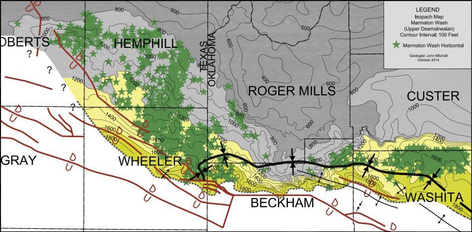
9 Shale Basin Marmaton Wash is Upper Desmoinesian in Age Contour Interval: 100 Ft Shale Basin Marmaton Wash is Upper Desmoinesian in Age Contour Interval: 100 Ft 9
: 618 Average 1 st Year Decline Rate-Oil: 82% Average Percent Payout on 1 st Year Production: 97% Marmaton B Wash = Carr Zone in Texas Usage")
10 Shale Basin Marmaton B Wash = Carr Zone in Texas Usage Shale Basin Key Horizontal Production Data for Interval Number of Horizontals Drilled thru Mid-2014: 138 Average Max Month Initial Potential (BOEPD): 618 Average 1 st Year Decline Rate-Oil: 82% Average Percent Payout on 1 st Year Production: 97% Marmaton B Wash = Carr Zone in Texas Usage 10
: 592 Average 1 st Year Decline Rate-Oil: 81% Average Percent Payout on 1 st Year Production: 84% Shale Basin Marmaton C Wash = Caldwell or Britt Zones in Texas")
11 Shale Basin Marmaton C Wash = Caldwell or Britt Zones in Texas Usage Key Horizontal Production Data for Interval Number of Horizontals Drilled thru Mid-2014: 373 Average Max Month Initial Potential (BOEPD): 592 Average 1 st Year Decline Rate-Oil: 81% Average Percent Payout on 1 st Year Production: 84% Shale Basin Marmaton C Wash = Caldwell or Britt Zones in Texas Usage 11
: 543 Average 1 st Year Decline Rate-Oil: 78% Average Percent Payout on 1 st Year Production: 83% Marmaton D Wash = Granite Wash A in Texas")
12 Marmaton D Wash = Granite Wash A in Texas Usage Key Horizontal Production Data for Interval Number of Horizontals Drilled thru Mid-2014: 527 Average Max Month Initial Potential (BOEPD): 543 Average 1 st Year Decline Rate-Oil: 78% Average Percent Payout on 1 st Year Production: 83% Marmaton D Wash = Granite Wash A in Texas Usage 12


 136 BOPD & 2.")
 45 BOPD & 8.")

13 SERIES / STAGE Drilled Horizontally To Date (Mid-2014) Missourian Wash Avg. Initial Potential 581 BOPD 1.7 MMCFGD GOR = 10, Wells U. Desmoinesian Wash Avg. Initial Potential 251 BOPD 5.0 MMCFGD GOR = 19, Wells Atokan Wash Avg. Initial Potential (Shallow) 136 BOPD & 2.2 MMCFGD GOR = 16, wells Avg. Initial Potential (Deep) 45 BOPD & 8.4 MMCFGD GOR 186, Wells Increasing Gas/Oil Ratio & Oil Gravity HRZ PERMITS BY YEAR THROUGH AUG PERMITTED HORIZONTAL GRANITE WASH WELLS BY OPERATOR THROUGH AUGUST


14 ANNUAL OIL PRODUCTION IN BBLS 25,000, MMBO 20,000,000 15,000,000 10,000,000 5,000, ANNUAL GAS PRODUCTION IN BCF 420 BCFG Play extends over 125 miles from Roberts County, TX to Washita County, OK Granite Wash reservoirs derived from erosion of Lower Paleozoic igneous and sedimentary rocks on adjacent Amarillo-Wichita uplift Sandstone and conglomerate reservoirs are 8,000 to 14,500 feet deep Sedimentary column 2,500 to 5,000 feet thick Reservoirs in arkosic sandstones & conglomerates 20 to 200 feet thick Reservoirs mainly deposited in southwest to northeast trends Stratigraphic traps are dominant trap type Play limited on southwest by faults & water bearing massive sandstones; limited on north/northeast by thinning of reservoirs into distal silt facies Oil/gas source for Granite Wash believed to be Pennsylvanian age shales The western Anadarko Basin horizontal Pennsylvanian Granite Wash play has had 2,092 horizontals wells drilled since 2002, mostly since 2010 More than 85 million barrels of oil and 1.8 TCF of gas produced from over 1600 horizontal wells primarily over the last three years 2013 horizontal Granite Wash well production of 22.5 MMBO and 426 BCFG Est. horizontal well daily production in March 2014 of 51,000 BOPD, 1.1 BCFGPD & 110,000+ BWPD 14
15 Many thanks to several colleagues who generously gave me their time and insights into the Granite Wash play. Also, eternal thanks to my lovely wife Carol Mitchell for her support and patience with my many long nights at the office over my career. 15
Economic Development of Pennsylvanian Age Granite Wash Reservoirs with Horizontal Wells in the Anadarko Basin*
 Economic Development of Pennsylvanian Age Granite Wash Reservoirs with Wells in the Anadarko Basin* John Mitchell 1 Search and Discovery Article #10734 (2015) Posted March 30, 2015 *Adapted from presentation
The Anadarko Basin: Oil and Gas Exploration Past, Present and Future
 The Anadarko Basin: Oil and Gas Exploration Past, Present and Future John Mitchell, Senior Geologist SM Energy Co. Tulsa, Oklahoma March 2012 Email: jmitchell@sm-energy.com Regional Location Map Ardmore-Marietta
BACKGROUND GEOLOGY. Hoaglund 1. Wichita Orogeny to the south (10k 15k uplift) Rapid erosion and deposition of uplifted granitic basement rock ~18,000
 Rapid erosion and deposition of uplifted granitic basement rock ~18,000") POST APPRAISAL OF THE MISSOURIAN HOGSHOOTER HYDROCARBON SYSTEM: IMPLICATIONS FOR FUTURE EXPLOITATION IN THE ANADARKO BASIN STEVE HOAGLUND (GEOLOGIST CHESAPEAKE ENERGY) BACKGROUND GEOLOGY Wichita Orogeny
POST APPRAISAL OF THE MISSOURIAN HOGSHOOTER HYDROCARBON SYSTEM: IMPLICATIONS FOR FUTURE EXPLOITATION IN THE ANADARKO BASIN STEVE HOAGLUND (GEOLOGIST CHESAPEAKE ENERGY) BACKGROUND GEOLOGY Wichita Orogeny
Geological Framework for Active Resource Plays in Oklahoma. Edith Newton Wilson, PhD Rock Whisperer LLC March 4, 2014
 Geological Framework for Active Resource Plays in Oklahoma Edith Newton Wilson, PhD Rock Whisperer LLC March 4, 2014 Oklahoma Oil Production 2000: 200,000 bopd* 2013: 300,000 bopd** 10 6 What Oklahoma
LAS ANIMAS ARCH PROVINCE (040)
") LAS ANIMAS ARCH PROVINCE (040) By C. William Keighin INTRODUCTION The Las Animas Arch of southeastern Colorado is a north-northeast striking structural high, bounded on the south by the Apishipa Uplift.
LAS ANIMAS ARCH PROVINCE (040) By C. William Keighin INTRODUCTION The Las Animas Arch of southeastern Colorado is a north-northeast striking structural high, bounded on the south by the Apishipa Uplift.
Lower Skinner Valley Fill Sandstones: Attractive Exploration Targets on the Northeast Oklahoma Platform*
 Lower Skinner Valley Fill Sandstones: Attractive Exploration Targets on the Northeast Oklahoma Platform* By Jim Puckette 1 Search and Discovery Article #10050 (2003) *Adapted from presentation to Tulsa
Depositional Model and Distribution of Marginal Marine Sands in the Chase Group, Hugoton Gas Field, Southwest Kansas and Oklahoma Panhandle
 Depositional Model and Distribution of Marginal Marine Sands in the Chase Group, Hugoton Gas Field, Southwest Kansas and Oklahoma Panhandle Nathan D. Winters, Martin K. Dubois, and Timothy R. Carr Kansas
Overview of Selected Shale Plays in New Mexico*
 Overview of Selected Shale Plays in New Mexico* Ron Broadhead 1 Search and Discovery Article #10627 (2014)** Posted August 18, 2014 *Adapted from presentation at RMAG luncheon meeting, Denver, Colorado,
Atlantic Rim Coalbed Methane Play: The Newest SuccessfulCBM Play in the Rockies
 Atlantic Rim Coalbed Methane Play: The Newest SuccessfulCBM Play in the Rockies Robert A. Lamarre Lamarre Geological, Denver, Colorado Stephen K. Ruhl Anadarko Petroleum Corporation, The Woodlands, Texas
The Marmaton of Western Kansas and Eastern Colorado SIPES Luncheon January 28, 2016
 The Marmaton of Western Kansas and Eastern Colorado SIPES Luncheon January 28, 2016 Presentation by: Jim Milne, Geologist Ancient Oceans Energy, Ltd. Outline Where are the Marmaton Fields? Production Expectations
Petroleum Systems (Part One) Source, Generation, and Migration
 Source, Generation, and Migration") Petroleum Systems (Part One) Source, Generation, and Migration GEOL 4233 Class January 2008 Petroleum Systems Elements Source Rock Migration Route Reservoir Rock Seal Rock Trap Processes Generation Migration
Petroleum Systems (Part One) Source, Generation, and Migration GEOL 4233 Class January 2008 Petroleum Systems Elements Source Rock Migration Route Reservoir Rock Seal Rock Trap Processes Generation Migration
For personal use only
 Date: 18 February 2019 ASX Code: WEL Directors John Kopcheff Non-Executive Chairman Neville Henry Managing Director Peter Allchurch Non-Executive Director James Hodges Non-Executive Director Larry Liu
Executive Summary Geologic Assessment of Undiscovered Oil and Gas Resources of the Eastern Great Basin Province, Nevada, Utah, Idaho, and Arizona
 Chapter 1 Executive Summary Geologic Assessment of Undiscovered Oil and Gas Resources of the Eastern Great Basin Province, Nevada, Utah, Idaho, and Arizona By U.S. Geological Survey Eastern Great Basin
2016 U.S. Geological Survey Assessment of Continuous Oil and Gas Resources in the Mancos Shale of the Piceance Basin
 2016 U.S. Geological Survey Assessment of Continuous Oil and Gas Resources in the Mancos Shale of the Piceance Basin U.S. Department of the Interior U.S. Geological Survey Uinta-Piceance Province Colorado
Sequence Stratigraphy. Historical Perspective
 Sequence Stratigraphy Historical Perspective Sequence Stratigraphy Sequence Stratigraphy is the subdivision of sedimentary basin fills into genetic packages bounded by unconformities and their correlative
Liberty Petroleum Corporation. Liberty Petroleum Corporation L-12-5 Review
 Liberty Petroleum Corporation L-12-5 Liberty Petroleum Corporation Western Australia Officer Basin Location: Officer Basin Australia Block size: 5,600,000 Acres Operator: Liberty chosen as preferred explorer,
Petroleum possibilities of the Cuervo trough, Tucumcari Basin, New Mexico
 Petroleum possibilities of the Cuervo trough, Tucumcari Basin, New Mexico Charles B. Reynolds and Irene B. Reynolds Geological Associates, 4409 San Andres NE, Albuquerque, New Mexico 87110 Abstract One
OIL AND GAS PLAYS OF THE MICHIGAN BASIN, SOUTHERN ONTARIO. Terry Carter, Consulting Geologist London, Ontario
 OIL AND GAS PLAYS OF THE MICHIGAN BASIN, SOUTHERN ONTARIO Terry Carter, Consulting Geologist London, Ontario 1 Ontario Petroleum Industries Oil and Natural Gas 1250 oil wells, 1200 gas wells, annual production
Downloaded 02/03/17 to Redistribution subject to SEG license or copyright; see Terms of Use at
 Multiattribute Seismic Facies Expressions of a Complex Granite Wash Formation - A Buffalo Wallow Field Illustration Oluwatobi Olorunsola, Lennon Infante, Bryce Hutchinson, Jie Qi and Kurt Marfurt ConocoPhillips
Barnett Shale-Woodford Shale play of the Delaware basin is it another giant shale gas field in Texas?
 Barnett Shale-Woodford Shale play of the Delaware basin is it another giant shale gas field in Texas? Bob Cluff The Discovery Group, Inc Denver, Colorado, USA bobcluff@discovery-group.com Delaware basin
Structural Geology Lab. The Objectives are to gain experience
 Geology 2 Structural Geology Lab The Objectives are to gain experience 1. Drawing cross sections from information given on geologic maps. 2. Recognizing folds and naming their parts on stereoscopic air
Update - Testing of the Strawn Sand, White Hat 20#3, Mustang Prospect, Permian Basin, Texas
 Date: 15 April 2019 ASX Code: WEL Directors John Kopcheff Non-Executive Chairman Neville Henry Managing Director Peter Allchurch Non-Executive Director Larry Liu Non-Executive Director Lloyd Flint Company
Dr. Kenneth B. Taylor, P.G.
 North Carolina Forestry Association 2013 Annual Meeting October 3, 2013 Shale Gas 101: Natural Gas Exploration / Development: A North Carolina Perspective presented by Dr. Kenneth B. Taylor, P.G. State
Predicting Initial Production of Granite Wash Horizontal Wells Using Old Well Logs and Cores. Strong correlation, eh?
 Oil Initial Production, STB/D Predicting Initial Production of Granite Wash Horizontal Wells Using Old Well Logs and Cores 13 November 2014 Granite Wash Workshop Strong correlation, eh? 4000 3000 2000
Cretaceous, Dakota Formation, Terra Cotta Member South Side of I-70, Salina County, Kansas
 Cretaceous, Dakota Formation, Terra Cotta Member South Side of I-70, Salina County, Kansas Written By: Steven D.J. Baumann G-102010-1A Outcrop looking southeast Photo taken by: Steven Baumann on 10-20-2010
Testing of the Strawn Sand, White Hat 20#3, Mustang Prospect, Permian Basin, Texas
 Date: 11 April 2019 ASX Code: WEL Directors John Kopcheff Non-Executive Chairman Neville Henry Managing Director Peter Allchurch Non-Executive Director Larry Liu Non-Executive Director Lloyd Flint Company
GEOLOGICAL JOHN C. FRYE, Chief URBANA
 STATE OF ILLINOIS WILLIAM G. STRATTON, Governor DEPARTMENT OF REGISTRATION AND EDUCATION VERA M. BINKS, Director STATE DIVISION OF THE GEOLOGICAL JOHN C. FRYE, Chief URBANA SURVEY ILLINOIS PETROLEUM 72
WEJCO. Exploration & Production. Eagle s Talon Prospect. The Eagle s Talon Prospect is located in south eastern Karnes County,
 WEJCO Exploration & Production Eagle s Talon Prospect The Eagle s Talon Prospect is located in south eastern Karnes County, Texas, within the new and highly prolific unconventional Eagle Ford Shale trend
The Bakken. A Non-Shale Shale Play. August 2010
 The Bakken A Non-Shale Shale Play August 2010 ConocoPhillips Unconventional Resource Experience in North America CBM San Juan Drunkards Wash Uinta Powder River Horseshoe Canyon Manville Shale Barnett Haynesville
IDENTIFICATION AND EVALUATION OF FLUVIAL-DOMINATED DELTAIC (CLASS 1 OIL) RESERVOIRS IN OKLAHOMA. YEARLY TECHNICAL PROGRESS REPORT for 1996
 RESERVOIRS IN OKLAHOMA. YEARLY TECHNICAL PROGRESS REPORT for 1996") IDENTIFICATION AND EVALUATION OF FLUVIAL-DOMINATED DELTAIC (CLASS 1 OIL) RESERVOIRS IN OKLAHOMA YEARLY TECHNICAL PROGRESS REPORT for 1996 Report Type: Annual Reporting Period: January 1 - December 31,
IDENTIFICATION AND EVALUATION OF FLUVIAL-DOMINATED DELTAIC (CLASS 1 OIL) RESERVOIRS IN OKLAHOMA YEARLY TECHNICAL PROGRESS REPORT for 1996 Report Type: Annual Reporting Period: January 1 - December 31,
QUARTERLY ACTIVITIES REPORT
 15 Rheola Street WEST PERTH WA 6005 Telephone: +61 8 9213 4388 Facsimile: +61 8 9213 4399 ASX Code: ETE ASX RELEASE 29 July 2011 QUARTERLY ACTIVITIES REPORT Entek Energy Limited provides the following
CHAPTER 2. GEOLOGIC SETTING Martin K. Dubois
 CHAPTER 2. GEOLOGIC SETTING Martin K. Dubois Regional Geology The Hugoton field lies on the west side of the Hugoton embayment of the Anadarko basin and is bounded to the northwest by the Las Animas arch
Search and Discovery Article #41255 (2014)** Posted February 11, 2014
** Posted February 11, 2014") Correlating Porosity with Acoustic Impedance in Sandstone Gas Reservoirs: Examples from the Atokan Sandstones of the Arkoma Basin, Southeastern Oklahoma* Ibrahim Çemen 1, Jeff Fuchs 1, Bill Coffey 2, Rodney
Correlating Porosity with Acoustic Impedance in Sandstone Gas Reservoirs: Examples from the Atokan Sandstones of the Arkoma Basin, Southeastern Oklahoma* Ibrahim Çemen 1, Jeff Fuchs 1, Bill Coffey 2, Rodney
Petroleum geology framework, West Coast offshore region
 Petroleum geology framework, West Coast offshore region James W. Haggart* Geological Survey of Canada, Vancouver, BC jhaggart@nrcan.gc.ca James R. Dietrich Geological Survey of Canada, Calgary, AB and
Petroleum Potential of the Application Area L12-4
 Petroleum Potential of the Application Area L12-4 The Application Area (L12-4) is underlain by the western Officer Basin, beneath the Gunbarrel Basin. The general basin architecture is outlined in Figure
SEDIMENTARY BASINSS S CANADA NORTH OF 60
 AAPG 2005 ANNUAL CONVENTION EXPLORING ENERGY SYSTEMS JUNE 20, 2005 - CALGARY, ALBERTA Updated to December 31, 2007 Canada's Discovered Oil and Gas Resources North of 60 Kenneth J. Drummond SEDIMENTARY
Seismic Data and Drilling in Hancock Co., Kentucky February 21, 2008
 Seismic Data and Drilling in Hancock Co., Kentucky February 21, 2008 J.A. Drahovzal 2/21/08 1 Hancock County (H1) Information Provided at 2/7/08 Meeting Depth of Top (t) and Thickness (th) in feet t Kn
Gravel Transport Can Determine Late Flood Tectonics
 Chapter 23 Gravel Transport Can Determine Late Flood Tectonics The locations of all the quartzite gravel in the northwest states and adjacent Canada provide more information about the Flood than just reinforcing
Horizontal San Andres Play
 Horizontal San Andres Play Russell K. Hall Presented at the CO 2 & ROZ Conference Dec 5, 2018 Midland, Texas CO 2 Recovery Conference Permian Basin Trends Horizontal San Andres Play PERMIAN BASIN TRENDS
entered a rapid development phase. Annual increased proven reserves are above 500 billion cubic meters (bcm) from 2003, and annual natural gas product
 from 2003, and annual natural gas product") (), entered a rapid development phase. Annual increased proven reserves are above 500 billion cubic meters (bcm) from 2003, and annual natural gas production has increased from 50bcm in 2000 to nearly
(), entered a rapid development phase. Annual increased proven reserves are above 500 billion cubic meters (bcm) from 2003, and annual natural gas production has increased from 50bcm in 2000 to nearly
0708 Carbon Sequestration and Enhanced Coalbed Methane Recovery Potential of the Cahaba and Coosa Coalfields in the Southern Appalachian Thrust Belt
 0708 Carbon Sequestration and Enhanced Coalbed Methane Recovery Potential of the Cahaba and Coosa Coalfields in the Southern Appalachian Thrust Belt M. R. McIntyre and J. C. Pashin Geological Survey of
Geologic influence on variations in oil and gas production from the Cardium Formation, Ferrier Oilfield, west-central Alberta, Canada
 Geologic influence on variations in oil and gas production from the Cardium Formation, Ferrier Oilfield, west-central Alberta, Canada Marco Venieri and Per Kent Pedersen Department of Geoscience, University
IN SOUTH DAKOTA PAST, PRESENT, AND FUTURE. GERALD (MACK) McGILLIVRAY OCTOBER 8-9, 2008
 McGILLIVRAY OCTOBER 8-9, 2008") SHALLOW GAS EXPLORATION & PRODUCTION IN SOUTH DAKOTA PAST, PRESENT, AND FUTURE BY GERALD (MACK) McGILLIVRAY 2009 ROCKY MOUNTAIN UNCONVENTIONAL GAS CONFERENCE OCTOBER 8-9, 2008 HISTORY OF SHALLOW GAS IN
SHALLOW GAS EXPLORATION & PRODUCTION IN SOUTH DAKOTA PAST, PRESENT, AND FUTURE BY GERALD (MACK) McGILLIVRAY 2009 ROCKY MOUNTAIN UNCONVENTIONAL GAS CONFERENCE OCTOBER 8-9, 2008 HISTORY OF SHALLOW GAS IN
BEFORE THE CORPORATION COMMISSION OF THE STATE OF OKLAHOMA MEWBOURNE OIL COMPANY DRILLING AND SPACING UNITS (HORIZONTAL UNIT)
") BEFORE THE CORPORATION COMMISSION OF THE STATE OF OKLAHOMA APPLICANT: MEWBOURNE OIL COMPANY RELIEF SOUG DRILLING AND SPACING UNITS (HORIZONTAL UNIT) LEGAL DESCRIPTION: SECTION 28, TOWNSHIP 15 NORTH, RANGE
BEFORE THE CORPORATION COMMISSION OF THE STATE OF OKLAHOMA APPLICANT: MEWBOURNE OIL COMPANY RELIEF SOUG DRILLING AND SPACING UNITS (HORIZONTAL UNIT) LEGAL DESCRIPTION: SECTION 28, TOWNSHIP 15 NORTH, RANGE
Sequence Stratigraphy of the Upper Cretaceous Niobrara Formation, A Bench, Wattenberg Field, Denver Julesburg Basin, Colorado*
 Sequence Stratigraphy of the Upper Cretaceous Niobrara Formation, A Bench, Wattenberg Field, Denver Julesburg Basin, Colorado* Lisa E. Remington LaChance 1 and Mark C. Robinson 1 Search and Discovery Article
The McCully gas field in southern New Brunswick was discovered in the year 2000 on a joint drilling exploration venture by Corridor Resources Inc.
 1 The McCully gas field in southern New Brunswick was discovered in the year 2000 on a joint drilling exploration venture by Corridor Resources Inc. and Potash Corporation of Saskatchewan. Located about
Overview of Unconventional Energy Resources of Oklahoma
 Overview of Unconventional Energy Resources of Oklahoma By Brian J. Cardott (Oklahoma Geological Survey) Presented at OGS Conference on Unconventional Energy Resources in the Southern Midcontinent in Oklahoma
Search and Discovery Article #20097 (2011) Posted January 31, 2011
 Posted January 31, 2011") Integrated Geological and Engineering Studies in Support of Producing Light Oil from a Frozen Reservoir: A Case Study from Umiat Oil Field, Northern Alaska* C. Hanks 1, J. Mongrain 2, A. Dandekar 2, P.
Integrated Geological and Engineering Studies in Support of Producing Light Oil from a Frozen Reservoir: A Case Study from Umiat Oil Field, Northern Alaska* C. Hanks 1, J. Mongrain 2, A. Dandekar 2, P.
Geologic History of Texas: The Making of Texas Over 1.5 Billion Years
 # 4 Geologic History of Texas: The Making of Texas Over 1.5 Billion Years Dr. Richard Kyle March 24, 2000 Produced by and for Hot Science - Cool Talks by the Environmental Science Institute. We request
BALOCHISTAN FOLDBELT BASIN
 INTRODUCTION BALOCHISTAN FOLDBELT BASIN The Kharan-3 block is located in the Kharan Trough of Balochistan Basin. GEOLOGICAL SETTING The Balochistan Province is an Upper Cretaceous to Recent structurally
RESERVOIR CHARACTERIZATION AND WATERFLOOD PERFORMANCE EVALUATION OF GRANITE WASH FORMATION, ANADARKO BASIN
 RESERVOIR CHARACTERIZATION AND WATERFLOOD PERFORMANCE EVALUATION OF GRANITE WASH FORMATION, ANADARKO BASIN A Thesis by AKSHAY ANAND NILANGEKAR Submitted to the Office of Graduate and Professional Studies
CENTRAL UTAH: A NEW OIL AND GAS PROVINCE
 CENTRAL UTAH: A NEW OIL AND GAS PROVINCE By Floyd and Mike By: Floyd Moulton and Mike Pinnell Wolverine Discovery Eastern Limit of Thrusting Presentation Outline Regional Setting Paleozoic Source Rock
Wattenberg Field Area, A Near Miss & Lessons Learned After 35 Years of Development History. Stephen A. Sonnenberg Robert J. Weimer
 Wattenberg Field Area, A Near Miss & Lessons Learned After 35 Years of Development History Stephen A. Sonnenberg Robert J. Weimer Front Wattenberg Field DJ Basin WYOMING Pay PIERRE SHALE Typical Depth
Unconventional Oil Plays Opportunity vs Risk
 Unconventional Oil Plays Opportunity vs Risk EnerCom s London Oil & Gas Conference 4 June 14, 2012 Sofitel London Danny D. Simmons 1000 BOPD - What a great well! 10,000 1,000 BOPD 100 10 12/2009 1/2010
EAS 233 Geologic Structures and Maps Winter Miscellaneous practice map exercises. 1. Fault and separation:
 Miscellaneous practice map exercises 1. Fault and separation: With respect to Map 1, what are (a) the orientation of the fault, and (b) the orientation of bedding in the units cut by the fault. (c) Mark
Geology & Geophysics Applied in Industry. EXERCISE 2: A Quick-Look Evaluation
 EXERCISE 2: A Quick-Look Evaluation You have been asked to perform a quick back-of-the-envelope evaluation of the blocks being offered off of Somewhereia. Is there enough potential that our company should
Vail et al., 1977b. AAPG 1977 reprinted with permission of the AAPG whose permission is required for further use.
 Well 5 Well 4 Well 3 Well 2 Well 1 Vail et al., 1977b AAPG 1977 reprinted with permission of the AAPG whose permission is required for further use. Well 5 Well 4 Well 3 Well 2 Well 1 Vail et al., 1977b
Introduction Geology
 Introduction The Wild Horse Anticline is located in the prolific Bighorn Basin of Wyoming about 5 miles northeast of the town of Basin. This structure demonstrates excellent fourway closure encompassing
NEVADA OIL WELL PROSPECT ROBBERS ROOST
 LC NEVADA OIL WELL PROSPECT ROBBERS ROOST Oil is a funny thing. It is likely to turn up in the most unlikely places. -J. PAUL GETTY Wildcatter, Billionaire ROBBERS ROOST ECONOMIC PROJECTION $5/Bbl. An
Subsurface Maps. K. W. Weissenburger. Isopach. Isochore. Conoco, Inc. Ponca City, Oklahoma, U.S.A.
 Subsurface Maps K. W. Weissenburger Conoco, Inc. Ponca City, Oklahoma, U.S.A. INTRODUCTION Reservoir properties are mapped to promote optimal field development. Subsurface maps dictate well placement and
NXT Energy Solutions Inc.
 SFD Case Example:, Western Canada (Stratigraphic Trapping) Lower Cretaceous Fluvial channel system of the Mannville Group is one of the most prolific hydrocarbon bearing strata in the province of Alberta.
NAME HOMEWORK ASSIGNMENT #3 MATERIAL COVERS CHAPTERS 8, 9, 10, 11
 NAME HOMEWORK ASSIGNMENT #3 MATERIAL OVERS HAPTERS 8, 9, 10, 11 Assignment is due the beginning of the class period on November 23, 2004. Answers for each chapter will be discussed in class, as Exam #3
Risk Factors in Reservoir Simulation
 Risk Factors in Reservoir Simulation Dr. Helmy Sayyouh Petroleum Engineering Cairo University 12/26/2017 1 Sources Of Data Petro-physical Data Water saturation may be estimated from log analysis, capillary
SCOOP HORIZONTAL WOODFORD PROJECT
 SCOOP HORIZONTAL WOODFORD PROJECT Far West Development (FWD) Proposes a non operated Horizontal Woodford Shale well (10,000 lateral) in the South Central Oklahoma Oil Province SCOOP. Newfield Exploration
Sedimentary Cycle Best Practice: Potential Eo-Oligocene Sediments in Western Indonesia*
 Sedimentary Cycle Best Practice: Potential Eo-Oligocene Sediments in Western Indonesia* Mellinda Arisandy 1 and I Wayan Darma 1 Search and Discovery Article #11008 (2017)** Posted November 6, 2017 *Adapted
UNIVERSITY OF OKLAHOMA GRADUATE COLLEGE STRATIGRAPHY AND RESERVOIR CHARACTERISTICS OF THE DESMOINESIAN GRANITE WASH (MARMATON GROUP), SOUTHERN
, SOUTHERN") UNIVERSITY OF OKLAHOMA GRADUATE COLLEGE STRATIGRAPHY AND RESERVOIR CHARACTERISTICS OF THE DESMOINESIAN GRANITE WASH (MARMATON GROUP), SOUTHERN ANADARKO BASIN A THESIS SUBMITTED TO THE GRADUATE FACULTY
UNIVERSITY OF OKLAHOMA GRADUATE COLLEGE STRATIGRAPHY AND RESERVOIR CHARACTERISTICS OF THE DESMOINESIAN GRANITE WASH (MARMATON GROUP), SOUTHERN ANADARKO BASIN A THESIS SUBMITTED TO THE GRADUATE FACULTY
Subsurface Geology and Resource Exploration
 LAB 11. Subsurface Geology and Resource Exploration Locating earth resources such as aluminum, copper, gold and gemstones has been an important job for geologists for a long time. This lab deals with the
B.C. s Offshore Oil and Gas: a Guide to the Geology and Resources.
 B.C. s Offshore Oil and Gas: a Guide to the Geology and Resources. Introduction Beneath the offshore regions of British Columbia are four moderately large, geologically young sedimentary basins (Figure
The Impact of Parasequence Stacking Patterns on Vertical Connectivity Between Wave-Dominated, Shallow Marine Parasequences, Book Cliffs, Eastern Utah
 The Impact of Parasequence Stacking Patterns on Vertical Connectivity Between Wave-Dominated, Shallow Marine Parasequences, Book Cliffs, Eastern Utah MALCOLM J. ARNOT and TIMOTHY R. GOOD* MALCOLM J. ARNOT
Profit Island Project East Baton Rouge Parish, Louisiana
 Profit Island Project Lower Tuscaloosa Play Blue Moon Exploration Company has identified and leased four excellent low risk development opportunities for substantial reserves in the Profit Island Field
Integrated Study Leading to Discovery of Thin Pay Sands and Challenges Associated with Development. Shaikh Abdul Azim
 Integrated Study Leading to Discovery of Thin Pay Sands and Challenges Associated with Development Shaikh Abdul Azim February 10, 2014 Outline Location and Geological Setting Zubair in RA and SA Fields
Morrow Series Study. of the Las Animas Arch Region
 Morrow Series Study of the Las Animas Arch Region Morrow Series of the Las Animas Arch Region Overview GeoDigital Information's Morrow Series study is designed to enhance both exploration and development
OKLAHOMA 2006 DRILLING ACTIVITY By Dan T. Boyd, Oklahoma Geological Survey
 OKLAHOMA 2006 DRILLING ACTIVITY By Dan T. Boyd, Oklahoma Geological Survey This article is the second in an ongoing series outlining annual drilling activity in Oklahoma. The first was published in the
An Analytic Approach to Sweetspot Mapping in the Eagle Ford Unconventional Play
 An Analytic Approach to Sweetspot Mapping in the Eagle Ford Unconventional Play Murray Roth*, Transform Software and Services, Denver, Colorado, Murray@transformsw.com Michael Roth, Transform Software
BACK TO BASICS WHY THE TORRES BASIN COULD BE A COMPANY MAKER Papua New Guinea :PPL326 A Frontier Basin
 BACK TO BASICS WHY THE TORRES BASIN COULD BE A COMPANY MAKER Papua New Guinea :PPL326 A Frontier Basin 1 Tertiary Carbonate/Clastic Prospects and Leads PNG_LNG Facility PPL326 has a large number of over
Case study: AVO analysis in a high-impedance Atoka Sandstone (Pennsylvanian), North Arkoma Basin, McIntosh County, Oklahoma
, North Arkoma Basin, McIntosh County, Oklahoma") Case study: AVO analysis in a high-impedance Atoka Sandstone (Pennsylvanian), North Arkoma Basin, McIntosh County, Oklahoma MOHAMED A. EISSA, Tanta University, Egypt, and University of Oklahoma, Norman,
Case study: AVO analysis in a high-impedance Atoka Sandstone (Pennsylvanian), North Arkoma Basin, McIntosh County, Oklahoma MOHAMED A. EISSA, Tanta University, Egypt, and University of Oklahoma, Norman,
Elevation s Barnett Oil Play: Its Genesis and Why it Works. April 25, 2018
 Elevation s Barnett Oil Play: Its Genesis and Why it Works April 25, 2018 UL Permian Basin Position Posted: 2018 Horizontal Spuds (IHS Energy) UL 2018 Partners Forum - April 25, 2018 2 April 2013 (Elevation
New Mexico Geological Society
 New Mexico Geological Society Downloaded from: http://nmgs.nmt.edu/publications/guidebooks/13 Paleontological reconnaissance of subsurface Pennsylvanian in southern pache and Navajo Counties, rizona Donald
Bulletin of Earth Sciences of Thailand. Evaluation of the Petroleum Systems in the Lanta-Similan Area, Northern Pattani Basin, Gulf of Thailand
 Evaluation of the Petroleum Systems in the Lanta-Similan Area, Northern Pattani Basin, Gulf of Thailand Sirajum Munira Petroleum Geoscience Program, Department of Geology, Faculty of Science, Chulalongkorn
Is It Likely That Fracking the Organic-Rich Utica Shale Beneath Bowling Green, OH Would Be Environmentally Safe?
 Is It Likely That Fracking the Organic-Rich Utica Shale Beneath Bowling Green, OH Would Be Environmentally Safe? Dr. Robert K. Vincent Prof. Emeritus, Dept. of Geology Bowling Green State University How
Source Sink Pipeline
 An Overview of Carbon Storage presented by Robert J. Finley Advanced Energy Technology Initiative Illinois State Geological Survey University of Illinois USA IEA Summer School Longyearbyen, Norway August,
DELINEATION OF SUBTLE GEOLOGIC FEATURES BY MULTI-ATTRIBUTE SEISMIC ANALYSIS IN DICKMAN FIELD, KANSAS, A POTENTIAL SITE FOR CO2 SEQUESTRATION
 DELINEATION OF SUBTLE GEOLOGIC FEATURES BY MULTI-ATTRIBUTE SEISMIC ANALYSIS IN DICKMAN FIELD, KANSAS, A POTENTIAL SITE FOR CO2 SEQUESTRATION Presented to The Faculty of the Department of Earth and Atmospheric
Thursday, March 19, 2015 Issued: 1:00pm CDT
 Thursday, March 19, 2015 Issued: 1:00pm CDT Prepared by: Kurt Van Speybroeck/Victor Murphy/David Brown 817-978-1100 x 147 National Weather Service Southern Region Headquarters Regional Operations Center
Reservoir Characterization for the Application of ASP Flood Technology in the Bridgeport Sandstone in Lawrence Field, Illinois*
 Reservoir Characterization for the Application of ASP Flood Technology in the Bridgeport Sandstone in Lawrence Field, Illinois* Nathan D. Webb 1, Vineeth Madhavan 1, John P. Grube 1, Curt S. Blakley 1,
Competent Person s Report on the Reserves Potential of the Lowry Bombing Range, Colorado, USA
 Competent Person s Report on the Reserves Potential of the Lowry Bombing Range, Colorado, USA On behalf of Highlands Natural Resources Plc Project Number: KRNACRR160769 Version: (Release) Date Submitted:
Geoscience 001 Fall Rock Identification and Contextual Interpretation
 Geoscience 00 Fall 2005 Rock Identification and Contextual Interpretation The purpose of this week s lab is to gain some more experience and practice in identifying rocks and then interpreting the geologic
Paleoslope and water depth estimate, lower Wolfcampian, Hugoton embayment of
 Paleoslope and water depth estimate, lower Wolfcampian, Hugoton embayment of the Anadarko basin Martin K. Dubois, Kansas Geological Survey Abstract Three criteria are used in combination to estimate paleoslope
The Booch Sandstones (McAlester Formation, Krebs Group), Arkoma Basin, Oklahoma Outcrops to Well Logs: An Introduction to Oklahoma Fluvial Reservoirs*
, Arkoma Basin, Oklahoma Outcrops to Well Logs: An Introduction to Oklahoma Fluvial Reservoirs*") The Booch Sandstones (McAlester Formation, Krebs Group), Arkoma Basin, Oklahoma Outcrops to Well Logs: An Introduction to Oklahoma Fluvial Reservoirs* Neil H. Suneson 1 Search and Discovery Article #10210
The Booch Sandstones (McAlester Formation, Krebs Group), Arkoma Basin, Oklahoma Outcrops to Well Logs: An Introduction to Oklahoma Fluvial Reservoirs* Neil H. Suneson 1 Search and Discovery Article #10210
Plate tectonics model for the continental collisions during Late Paleozoic
 Alleghanian orogeny During Late Paleozoic, northwestern Africa collided with southeastern North America, causing the Alleghanian orogeny, and building the Appalachian mountains. The orogeny began during
EXAMINER S REPORT AND RECOMMENDATION STATEMENT OF THE CASE
 OIL AND GAS DOCKET NO. 08-0248239 THE APPLICATION OF PETRO-HUNT, L.L.C. TO CONSIDER NEW FIELD DESIGNATION AND FIELD RULES FOR THE (PROPOSED) TOYAH, NW (SHALE) FIELD, REEVES COUNTY, TEXAS Heard by: Donna
Follow this and additional works at: Part of the Geology Commons
 Western Michigan University ScholarWorks at WMU Michigan Geological Repository for Research and Education Geosciences 2016 Geology of Michigan William B. Harrison III Michigan Geological Repository for
Unconventional Reservoir Development: The Role of Geoscience from a State Regulator s Perspective
 Unconventional Reservoir Development: The Role of Geoscience from a State Regulator s Perspective Nick Tew Alabama State Geologist and Oil and Gas Supervisor President, American Geosciences Institute Geological
Dakota Sandstone. of the Moxa Arch and Surrounding Green River Basin
 Dakota Sandstone of the Moxa Arch and Surrounding Green River Basin Dakota Sandstones of the Green River Basin Overview The Dakota sandstones of the Moxa Arch and surrounding Green River Basin remain attractive
A Model for Single-Phase Migration of Trenton-Black River Hydrocarbon in the Southern Michigan Basin*
 A Model for Single-Phase Migration of Trenton-Black River Hydrocarbon in the Southern Michigan Basin* Ron DeHaas 1 and Timothy Brock 2 Search and Discovery Article #10306 (2011) Posted March 14, 2011 *Adapted
Minnelusa Play: The impact of tectonics and an ancient dune field on production
 Minnelusa Play: The impact of tectonics and an ancient dune field on production Steven G. Fryberger ENHANCED OIL RECOVERY INSTITUTE Permian Tectonic Map of Wyoming 200 miles after Inden, et al, 1996 PermoPennsylvanian
Issues Related to Oklahoma Coalbed- Methane Activity,
 Figure 1. Map of the eastern Oklahoma coalfield (modified from Friedman, 1974). Issues Related to Oklahoma Coalbed- Methane Activity, 1988 2008 Brian J. Cardott Oklahoma Geological Survey INTRODUCTION
Relinquishment Report for Licence P.1265, Block 12/28
 Relinquishment Report for Licence P.1265, Block 12/28 1. Licence Information Licence Number: P.1265 Licence Round: 23 rd Round Awarded 22 December 2005 Licence Type: Traditional Block Number(s): 12/28
New Mexico Geological Society
 New Mexico Geological Society Downloaded from: http://nmgs.nmt.edu/publications/guidebooks/26 Tectonic significance of the Pony Hills, Luna County, New Mexico LeRoy L. Corbitt and Fred L. Nials, 1975,
Colorado s Underground Injection Control Program: Prevention and Mitigation of Induced Seismicity
 Colorado s Underground Injection Control Program: Prevention and Mitigation of Induced Seismicity Energy & Environment Symposium April 2015 Robert P. Koehler, PhD. UIC Lead OVERVIEW What is a UIC well?
HISTORY OF HARTZOG DRAW FIELD
 7 th ANNUAL WYOMING CO2 CONFERENCE HISTORY OF HARTZOG DRAW FIELD 11 JULY 2013 HARTZOG DRAW INTRODUCTION WELCOME Click to edit Master YOU ARE title HERE! style 3 TERRAIN Click to edit / SCENIC Master VIEW