Search and Discovery Article #41255 (2014)** Posted February 11, 2014
|
|
|
- Elfreda Cole
- 6 years ago
- Views:
Transcription
1 Correlating Porosity with Acoustic Impedance in Sandstone Gas Reservoirs: Examples from the Atokan Sandstones of the Arkoma Basin, Southeastern Oklahoma* Ibrahim Çemen 1, Jeff Fuchs 1, Bill Coffey 2, Rodney Gertson 2, and Christine Hager 3 Search and Discovery Article #41255 (2014)** Posted February 11, 2014 *Adapted from oral presentation given at AAPG Annual Convention and Exhibition, Pittsburgh, Pennsylvania, May 19-22, 2013 **AAPG 2013 Serial rights given by author. For all other rights contact author directly. 1 University of Alabama, Tuscaloosa, AL (icemen@as.ua.edu) 2 Devon Energy Company, Oklahoma City, OK 3 Exxon/Mobil Corporation, Houston, TX Abstract It has been suggested by several researchers that seismic impedance values determined from the 3D seismic inversion data can be used to locate the zones of low and high porosities in sandstone reservoirs. We have applied this concept to three well known sandstone gas reservoirs in the Arkoma foreland basin, located in southeast Oklahoma. The reservoirs are the lower Atokan Spiro; and middle Atokan Brazil and Red Oak sandstones. We used 3D seismic acoustic inversion volume calibrated to well control to map porosity changes in these three gas reservoirs. Every well with a sonic log within the survey area has been analyzed to understand velocity changes in these reservoirs along strike and dip of the main direction of thrusting. Structural control plays a major role in the productivity of these sandstone reservoirs. Therefore, we also determined the structural control on the porosity of these reservoirs by constructing several balanced structural cross-sections in the area of seismic inversion data because understanding the structure over an area is just as important as identifying changes in rock properties. Our interpretation of the seismic inversion data suggest that the areas of tighter anticlinal folds in our cross-sections correlate reasonably well with the lower acoustic impedance values due to fracture porosity in the Spiro Sandstone. In areas where the Spiro experienced facies changes, the acoustic impedance value is also a good predictor of porosity Therefore, acoustic impedance shows a reliable correlation with higher porosities as seen in areas of lower acoustic impedance in the Spiro reservoirs. However, we have not found a very reliable correlation between the porosity and acoustic impedance in the Brazil and Red Oak sandstones. We suggest that this is due to the variable shale content together with the tuning thickness of intervals. The two sandstone units contain thick shale sections because of the nature of their depositional environment. Therefore, seismic inversion data seem not to be a reliable predictor of porosity where thick shale sections are present. When we isolate the homogeneous sandstone parts of the two units, however, there is a linear correlation between the acoustic impedance and porosity. We suggest that determining the linear relationship between the acoustic impedance and porosity may be used only in relatively thick sandstone reservoirs.
2 References Cited Arbenz, J. K., 2008, Structural framework of the Ouachita Mountain, in Suneson, N. H., ed., Stratigraphic and structural evolution of the Ouachita Mountains and Arkoma Basin, south-eastern Oklahoma and west-central Arkansas: applications to petroleum exploration: 2004 field symposium. The Arbenz-Misch/Oles volume: Oklahoma Geological Survey Circular 112A, p Calderon, J.E. and J. Castagna, 2007, Porosity and lithologic estimation using rock physics and multi-attribute transforms in Balcon Field, Colombia: Leading Edge, v. 26/2, p Cemen, I., A. Sagnak, and S. Akthar, 2001a, Geometry of the triangle zone and duplex structure in the Wilburton gas field area of the Arkoma Basin, southeastern Oklahoma, in K.S. Johnson, ed., Pennsylvanian and Permian geology and petroleum in the southern Midcontinent, 1998 symposium: Oklahoma Geological Survey Circular, Report #104, p Çemen, I., J. Evans, and A. Sagnak, 2001b, Eastern continuation of the Wilburton triangle zone in the Red Oak gas-field area, frontal Ouachitas-Arkoma basin transition zone, southeastern Oklahoma, in Johnson, K.S.; and Merriam, D.F. (eds), Petroleum systems of sedimentary basins in the southern Midcontinent, 2000 symposium: Oklahoma Geological Survey Circular 106, p Houseknecht, D.W., J.K. Zaengle, D.J. Steyaerk, A.P. Matteo, Jr., and M.A. Kuhn, 1983, Facies and depositional environments of the Desmoinesian Hartshorne Sandstone, Arkoma Basin, in D.W. Houseknecht, ed., Tectonic-sedimentary evolution of the Arkoma Basin and guidebook to deltaic facies, Hartshorne Sandstone: SEPM, v. 1, p Pedersen-Tatalovic, R., A. Uldall, N. Lange-Jacobsen, T. Mejer-Hansen, and K. Mosegaard, 2008, Event-based low-frequency impedance modeling using well logs and seismic attributes: Leading Edge, v. 27/5, p Sahai, S., and I. Çemen, 2008, Enhanced structural interpretation in the Arkoma Basin with seismic attributes, in N.H. Suneson, and I. Çemen, eds., Stratigraphic and Structural Evolution of the Ouachita Mountains and Arkoma Basin, southeastern Oklahoma and west-central Arkansas: Applications to petroleum exploration, 2004 field symposium, technical papers: Oklahoma Geological Survey Circular 112B, p Sutherland, P.K., 1988, Late Mississippian and Pennsylvanian depositional history in the Arkoma Basin area, Oklahoma and Arkansas: GSA Bulletin, v. 100/11, p
3 Correlating Porosity with Acoustic Impedance in Sandstone Gas Reservoirs: Examples from the Atokan Sandstones of fthe Arkoma Basin, Southeastern Oklahoma Ibrahim Çemen 1, Jeff Fuchs 1, Bill Coffey 2, Rodney Gertson 2, Christine Hager 3 1 University of Alabama, Tuscaloosa, AL, United States. 2 Devon Energy Company, Oklahoma City, OK, United States. 3 Exxon/Mobil Corporation, Houston, TX, United States.
4 37" 27" Wlor W9r wsr The Arkoma basin is a foreland basin of the Ouachita fold and thrust belt formed Cemen during the Pennsylvanian Ouachita Orogeny. I
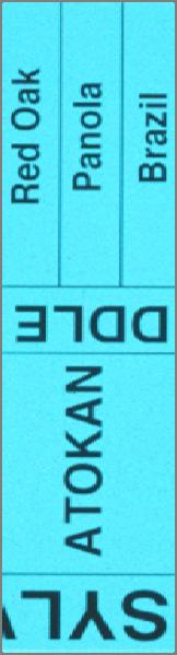
5 The Arkoma Basin contains 4.26 trillion cubic feet undiscovered natural gas, mostly in the Atokan Sandstones. The basin produces gas mostly from the Atokan reservoirs, such as the lower Atokan Spiro, Panola, Brazil and middle Atokan Red Oak sandstones.


 High subsidence")
")

6 Geologic overview Sahai and Çemen, 2008 The Arkoma Basin is one of the best foreland basins in the world to study how strain partitions from highly hl deformed d fold-thrust belt to mildly deformed foreland basins because: a) High subsidence and sedimentation rates during thrusting in late Mississippian and Pennsylvanian; b) Thrusting has not been effected by later events such as extension and/or strike-slip faulting Çemen Arbenz, 2008


7 Generalized Stratigraphy of the Ouachitas and Arkoma Basin Houseknecht, et al., 1983 Cemen et al., 2001a The Atoka Formation contains mostly deep marine shale deposits but also includes some sandstone units. The Spiro Sandstone forms the base of the Atokan Formation and is an important reservoir sand.
 w Z ō ~ \I') w o z «~ o ~ z ~ o 0::: 0::: o ~ o::z w O tii~ ;;J.")


8 - Z <t ~ > V) z z w c.. z «\I') w Z ō ~ \I') w o z «~ o ~ z ~ o 0::: 0::: o ~ o::z w O tii~ ;;J.~ u o:: ~O u.. W z ~O ~~ Vl ~... 0:: 0:: <tu.. 0 J: w... c ::i: KEOTA SANDSTO NE TAMAHA SANDSTONE CAMERO N SANDSTO NE BOOCH SANDSTONE HARTSHORNE SANDSTONE W EBBERS FALLS SANDSTONE GllCR AS SANDSTON FANSHAWESANOSTONE REDOAKSANDSTON +~I- PANOlASANDSTON - DIAMOND SANDSTON 8RAZllSANDSTON +~I- CECllSANDSTONE... SHAYSANDSTON SPIROSANDSTON - - FOSTER SANDSTONE ~ ~ WAPANUCKA LIMESTONE UNION VALLEY LIMESTONE CROMWELL LIMESTONE SPRINGER SHALE Detailed stratigraphy the Pennsylvanian system of units within the Arkoma Basin (modified from Sutherland, 1988).

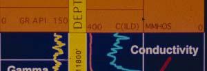
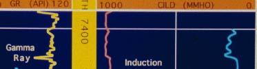

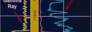
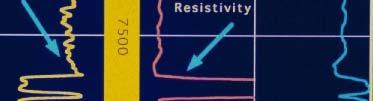


9 Major Pennsylvanian sandstones of the Atoka Formation Cemen (Cemen et al., 2001a) Log Signatures of the Spiro and Red Oak sandstones, two major gas reservoirs in the Wilburton, and Hartshorne gas fields
10 Seismic Inversion: Seismic impedance values are shown to correlate with porosities in sandstone reservoirs. A) Cross-plot of porosity versus acoustic impedance with the color scale corresponding to different wells for Cretaceous sandstones in Magdalena Valley, Columbia (Calderon and Castagna, 2007). B)Examples from the Danish North Sea (Pedersen-Tatalovic et al., 2008).Lower acoustic impedance values correlate with higher porosity values.
11 In recent years, we applied this concept to three well known sandstone gas reservoirs in the Arkoma basin. The reservoirs are the lower Atokan Spiro and middle Atokan Brazil and Red Oak sandstones. Every well with a sonic log within the survey area has been analyzed to understand velocity changes.
12 Seismic Inversion Full stack inversion was done by Odegaard America Inc. Workflow Data QC- Seismic, wells and horizons Log calibration Wavelet estimation Low Frequency model Inversion 3 wells were used Inversion performed using a constant phase wavelet.
13 Impedance vs. Porosity SPIRO (1) Petit well depth interval (69ft thick) structurally higher Spiro Z (Impedan nce gft/ccs) Highest porosity values ->Lower impedance values Series Porosity (phi)
14 Impedance vs. Porosity Spiro (2) Petit well (62 ft thick) Structurally lower Spiro Z (Impedan nce gft/cs) Highest porosity values ->Lower impedance values Series Porosity (phi)
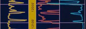
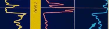
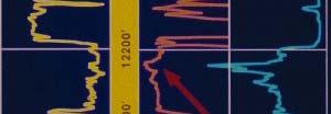
15 Porosity vs Seismic Impedance: Brazil Sandstone 25,000 33,000 41,000 49,000 DT AI PORZ GR Calculated AI (gft/cm 3 s) Cross-plots of porosity versus acoustic impedance for sandy (yellow polygon) and shaly (black polygon) portions of the Brazil Sandstone. Sand portions are marked with yellow on the logs. Points in yellow polygon are the sandy portions of the interval and points in black polygon are the shaly portions of the interval. DT=Sonic; AI=Acoustic Impedance PORZ=Porosity GR=Gamma Ray
16 Porosity vs Seismic Impedance: Red Oak Sandstone 25,000 33,000 41,000 49,000 DT AI PORZ GR Calculated AI (gft/cm 3 s) Cross-plots of porosity versus acoustic impedance for sandy (Yellow poligon) and shaly (Black polygon) portions of the Red Oak Sandstone. Sand portions are marked with yellow on the logs. Points in yellow polygon are the sandy portions of the interval and points in black polygon are the shaly portions of the interval. DT=Sonic; AI=Acoustic Impedance PORZ=Porosity GR=Gamma Ray
17 CONCLUSIONS There is a relatively ygood correlation between the seismic impedance and porosity where reservoir is an homogenous, thick sandstone (at least 100 feet) like the Spiro Sandstone. Ali linear correlation between calculated l acoustic impedance and porosity in the sandstone portions of the Red Oak and Brazil rock units also exists. Higher porosities in these two sandstone reservoirs are correlated with areas of lower acoustic impedance within the sandstone portions of the units. However, interbedded shale units within the Brazil and Red Oak reservoirs appear to inhibit a reliable correlation between the seismic acoustic impedance and porosity.
USING 3-D SEISMIC INVERSION DATA AS A TOOL FOR PREDICTING POROSITY IN THE WILBURTON GAS FIELD, ARKOMA BASIN, SOUTHEASTERN OKLAHOMA
 USING 3-D SEISMIC INVERSION DATA AS A TOOL FOR PREDICTING POROSITY IN THE WILBURTON GAS FIELD, ARKOMA BASIN, SOUTHEASTERN OKLAHOMA by JEFFREY CHARLES FUCHS IBRAHIM ÇEMEN, COMMITTEE CHAIR ANDREW GOODLIFFE
Case study: AVO analysis in a high-impedance Atoka Sandstone (Pennsylvanian), North Arkoma Basin, McIntosh County, Oklahoma
, North Arkoma Basin, McIntosh County, Oklahoma") Case study: AVO analysis in a high-impedance Atoka Sandstone (Pennsylvanian), North Arkoma Basin, McIntosh County, Oklahoma MOHAMED A. EISSA, Tanta University, Egypt, and University of Oklahoma, Norman,
Case study: AVO analysis in a high-impedance Atoka Sandstone (Pennsylvanian), North Arkoma Basin, McIntosh County, Oklahoma MOHAMED A. EISSA, Tanta University, Egypt, and University of Oklahoma, Norman,
The Geology of the Arbuckle Group in the Midcontinent: Sequence Stratigraphy, Reservoir Development, and the Potential for Hydrocarbon Exploration*
 The Geology of the Arbuckle Group in the Midcontinent: Sequence Stratigraphy, Reservoir Development, and the Potential for Hydrocarbon Exploration* Richard D. Fritz 1, Patrick Medlock 2, Michael J. Kuykendall
Downloaded 11/02/16 to Redistribution subject to SEG license or copyright; see Terms of Use at Summary.
 in thin sand reservoirs William Marin* and Paola Vera de Newton, Rock Solid Images, and Mario Di Luca, Pacific Exploración y Producción. Summary Rock Physics Templates (RPTs) are useful tools for well
SEG/San Antonio 2007 Annual Meeting
 ; Application to Forth Worth Basin Suat Aktepe, Kurt J. Marfurt, Center for Applied Geosciences and Energy, Dept. of Geosciences, University of Houston Summary By definition, the focus of seismic exploration
Stratigraphy and Structure of a South-Trending Structural High, Northern Arkoma Basin, Arkansas
 University of Arkansas, Fayetteville ScholarWorks@UARK Theses and Dissertations 8-2016 Stratigraphy and Structure of a South-Trending Structural High, Northern Arkoma Basin, Arkansas Yirong Chen University
Overview of Selected Shale Plays in New Mexico*
 Overview of Selected Shale Plays in New Mexico* Ron Broadhead 1 Search and Discovery Article #10627 (2014)** Posted August 18, 2014 *Adapted from presentation at RMAG luncheon meeting, Denver, Colorado,
Case Study of the Structural and Depositional-Evolution Interpretation from Seismic Data*
 Case Study of the Structural and Depositional-Evolution Interpretation from Seismic Data* Yun Ling 1, Xiangyu Guo 1, Jixiang Lin 1, and Desheng Sun 1 Search and Discovery Article #20143 (2012) Posted April
IJISET - International Journal of Innovative Science, Engineering & Technology, Vol. 2 Issue 9, September 2015.
 Prediction of petrophysical parameters applying multi attribute analysis and probabilistic neural network techniques of seismic data for Komombo Basin, Upper Egypt. Othman, A. A. A. 1, Ewida, H. F. 2,
SEISMIC INTERPRETATION OF PENNSLYVANIAN ATOKAN STRATA USING 3D SEISMIC INVERSION DATA, WILBURTON GAS FIELD, ARKOMA BASIN, SOUTHEASTERN OKLAHOMA
 SEISMIC INTERPRETATION OF PENNSLYVANIAN ATOKAN STRATA USING 3D SEISMIC INVERSION DATA, WILBURTON GAS FIELD, ARKOMA BASIN, SOUTHEASTERN OKLAHOMA By CHRISTINE ROBIN HAGER Bachelor of Science in Geology Oklahoma
Stratigraphy and Hydrocarbon Production from Pennsylvanian Age Granite Wash Reservoirs in the Western Anadarko Basin, Oklahoma and Texas
 Stratigraphy and Hydrocarbon Production from Pennsylvanian Age Granite Wash Reservoirs in the Western Anadarko Basin, Oklahoma and Texas John Mitchell, Managing Partner/Consulting Geologist Fall River
Osareni C. Ogiesoba 1. Search and Discovery Article #10601 (2014)** Posted May 31, 2014
** Posted May 31, 2014") Seismic Multiattribute Analysis for Shale Gas/Oil within the Austin Chalk and Eagle Ford Shale in a Submarine Volcanic Terrain, Maverick Basin, South Texas* Osareni C. Ogiesoba 1 Search and Discovery Article
Seismic Multiattribute Analysis for Shale Gas/Oil within the Austin Chalk and Eagle Ford Shale in a Submarine Volcanic Terrain, Maverick Basin, South Texas* Osareni C. Ogiesoba 1 Search and Discovery Article
Bulletin of Earth Sciences of Thailand
 Quantitative Seismic Geomorphology of Early Miocene to Pleistocene Fluvial System of Northern Songkhla Basin, Gulf of Thailand Oanh Thi Tran Petroleum Geoscience Program, Department of Geology, Faculty
Downloaded 01/29/13 to Redistribution subject to SEG license or copyright; see Terms of Use at
 An integrated study of a Mississippian tripolitic chert reservoir Osage County, Oklahoma, USA Benjamin L. Dowdell*, Atish Roy, and Kurt J. Marfurt, The University of Oklahoma Summary With the advent of
Characterizing Seal Bypass Systems at the Rock Springs Uplift, Southwest Wyoming, Using Seismic Attribute Analysis*
 Characterizing Seal Bypass Systems at the Rock Springs Uplift, Southwest Wyoming, Using Seismic Attribute Analysis* Yuri Ganshin 1 and Fred McLaughlin 1 Search and Discovery Article #80483 (2015)** Posted
Search and Discovery Article #10532 (2013)** Posted October 21, Abstract
** Posted October 21, Abstract") Utilizing the Delta Log R Method for Determining Total Organic Carbon of the Niobrara Formation, B Bench, Denver-Julesburg Basin, Colorado and Wyoming* Madeline K. Beitz 1, Robert Cunningham 2, and Lisa
Utilizing the Delta Log R Method for Determining Total Organic Carbon of the Niobrara Formation, B Bench, Denver-Julesburg Basin, Colorado and Wyoming* Madeline K. Beitz 1, Robert Cunningham 2, and Lisa
Subsurface Structural Analysis Using Well Logs to Study Faults of the Lower Atokan Formation in the Arkoma Basin, Northcentral Arkansas
 IOSR Journal of Environmental Science, Toxicology and Food Technology (IOSR-JESTFT) e-issn: 2319-2402,p- ISSN: 2319-2399.Volume 11, Issue 5 Ver. II (May. 2017), PP 65-77 www.iosrjournals.org Subsurface
Southern Songkhla Basin, Gulf of Thailand
 Architecture and Depositional Environment of Fluvial Systems of Southern Songkhla Basin, Gulf of Thailand Toan Manh Do Petroleum Geoscience Program, Department of Geology, Faculty of Science, Chulalongkorn
The McCully gas field in southern New Brunswick was discovered in the year 2000 on a joint drilling exploration venture by Corridor Resources Inc.
 1 The McCully gas field in southern New Brunswick was discovered in the year 2000 on a joint drilling exploration venture by Corridor Resources Inc. and Potash Corporation of Saskatchewan. Located about
3D Seismic Reservoir Characterization and Delineation in Carbonate Reservoir*
 3D Seismic Reservoir Characterization and Delineation in Carbonate Reservoir* M. N. Alamsyah 1, Bambang W. Handono 1, and Andri Syafriya 1 Search and Discovery Article #41760 (2016) Posted January 25,
STRUCTURAL GEOMETRY OF THE FRONTAL OUACHITAS-ARKOMA BASIN TRANSITION ZONE IN WESTERN ARKANSAS DONALD JORDAN YEZERSKI
 STRUCTURAL GEOMETRY OF THE FRONTAL OUACHITAS-ARKOMA BASIN TRANSITION ZONE IN WESTERN ARKANSAS By DONALD JORDAN YEZERSKI IBRAHIM ÇEMEN, COMMITTEE CHAIR ANDREW M. GOODLIFFE DELORES C. ROBINSON JACK C. PASHIN
Seismic modeling evaluation of fault illumination in the Woodford Shale Sumit Verma*, Onur Mutlu, Kurt J. Marfurt, The University of Oklahoma
 Seismic modeling evaluation of fault illumination in the Woodford Shale Sumit Verma*, Onur Mutlu, Kurt J. Marfurt, The University of Oklahoma Summary The Woodford Shale is one of the more important resource
Calcite Cements in Middle Devonian Dunedin Formation:
 Geochemistry of the Fracture-Filling Dolomite and Calcite Cements in Middle Devonian Dunedin Formation: Implication for the Strata Dolomitization Model Sze-Shan Yip 1, Hairuo Qing 1 and Osman Salad Hersi
Sequence Stratigraphy of the Upper Cretaceous Niobrara Formation, A Bench, Wattenberg Field, Denver Julesburg Basin, Colorado*
 Sequence Stratigraphy of the Upper Cretaceous Niobrara Formation, A Bench, Wattenberg Field, Denver Julesburg Basin, Colorado* Lisa E. Remington LaChance 1 and Mark C. Robinson 1 Search and Discovery Article
CENTRAL UTAH: A NEW OIL AND GAS PROVINCE
 CENTRAL UTAH: A NEW OIL AND GAS PROVINCE By Floyd and Mike By: Floyd Moulton and Mike Pinnell Wolverine Discovery Eastern Limit of Thrusting Presentation Outline Regional Setting Paleozoic Source Rock
Sequence Stratigraphy. Historical Perspective
 Sequence Stratigraphy Historical Perspective Sequence Stratigraphy Sequence Stratigraphy is the subdivision of sedimentary basin fills into genetic packages bounded by unconformities and their correlative
PETROLEUM GEOSCIENCES GEOLOGY OR GEOPHYSICS MAJOR
 PETROLEUM GEOSCIENCES GEOLOGY OR GEOPHYSICS MAJOR APPLIED GRADUATE STUDIES Geology Geophysics GEO1 Introduction to the petroleum geosciences GEO2 Seismic methods GEO3 Multi-scale geological analysis GEO4
Downloaded 09/15/16 to Redistribution subject to SEG license or copyright; see Terms of Use at
 A Full Field Static Model of the RG-oil Field, Central Sirte Basin, Libya Abdalla Abdelnabi*, Kelly H. Liu, and Stephen Gao Missouri University of Science and Technology Summary Cambrian-Ordovician and
Oil and Natural Gas Corporation Ltd., VRC(Panvel), WOB, ONGC, Mumbai. 1
, WOB, ONGC, Mumbai. 1") P-259 Summary Data for identification of Porosity Behaviour in Oligocene Lime Stone of D18 Area Of Western Offshore, India V.K. Baid*, P.H. Rao, P.S. Basak, Ravi Kant, V. Vairavan 1, K.M. Sundaram 1, ONGC
P-259 Summary Data for identification of Porosity Behaviour in Oligocene Lime Stone of D18 Area Of Western Offshore, India V.K. Baid*, P.H. Rao, P.S. Basak, Ravi Kant, V. Vairavan 1, K.M. Sundaram 1, ONGC
Stratigraphic and Structural Analysis of Middle Atoka Formation in Aetna Gas Field, Franklin, Johnson and Logan Counties, Arkansas
 University of Arkansas, Fayetteville ScholarWorks@UARK Theses and Dissertations 12-2015 Stratigraphic and Structural Analysis of Middle Atoka Formation in Aetna Gas Field, Franklin, Johnson and Logan Counties,
Shale Gas Potential in the Eastern Cordillera of Colombia*
 Shale Gas Potential in the Eastern Cordillera of Colombia* Mario Garcia-Gonzalez 1 Search and Discovery Article #10286 (2010) Posted December 17, 2010 *Adapted from oral presentation at AAPG International
Tim Carr - West Virginia University
 Tim Carr - West Virginia University Understanding Seismic Data Resolution (Vertical and Horizontal) Common Depth Points (CDPs) Two way time (TWT) Time versus depth Interpretation of Reflectors 2 Able to
Depositional History and Petroleum Potential of Ombilin Basin, West Sumatra - Indonesia, Based on Surface Geological Data*
 Depositional History and Petroleum Potential of Ombilin Basin, West Sumatra - Indonesia, Based on Surface Geological Data* Yahdi Zaim 1, Litto Habrianta 2, Chalid I. Abdullah 1, Aswan 1, Yan Rizal 1, Nurcahyo
Abstract. Introduction. Regional Setting. GCSSEPM to be published December 2003
 Shelf Margin Deltas and Associated Deepwater Deposits: Implications on Reservoir Distribution and Hydrocarbon Entrapment, Block VI-1, Ulleung Basin, East Sea, South Korea Sneider, John S. Sneider Exploration,
Simultaneous Inversion of Clastic Zubair Reservoir: Case Study from Sabiriyah Field, North Kuwait
 Simultaneous Inversion of Clastic Zubair Reservoir: Case Study from Sabiriyah Field, North Kuwait Osman Khaled, Yousef Al-Zuabi, Hameed Shereef Summary The zone under study is Zubair formation of Cretaceous
The reason why acoustic and shear impedances inverted
 SPECIAL The Rocky SECTION: Mountain The Rocky region Mountain region Comparison of shear impedances inverted from stacked PS and SS data: Example from Rulison Field, Colorado ELDAR GULIYEV, Occidental
Lower Skinner Valley Fill Sandstones: Attractive Exploration Targets on the Northeast Oklahoma Platform*
 Lower Skinner Valley Fill Sandstones: Attractive Exploration Targets on the Northeast Oklahoma Platform* By Jim Puckette 1 Search and Discovery Article #10050 (2003) *Adapted from presentation to Tulsa
The Booch Sandstones (McAlester Formation, Krebs Group), Arkoma Basin, Oklahoma Outcrops to Well Logs: An Introduction to Oklahoma Fluvial Reservoirs*
, Arkoma Basin, Oklahoma Outcrops to Well Logs: An Introduction to Oklahoma Fluvial Reservoirs*") The Booch Sandstones (McAlester Formation, Krebs Group), Arkoma Basin, Oklahoma Outcrops to Well Logs: An Introduction to Oklahoma Fluvial Reservoirs* Neil H. Suneson 1 Search and Discovery Article #10210
The Booch Sandstones (McAlester Formation, Krebs Group), Arkoma Basin, Oklahoma Outcrops to Well Logs: An Introduction to Oklahoma Fluvial Reservoirs* Neil H. Suneson 1 Search and Discovery Article #10210
The SPE Foundation through member donations and a contribution from Offshore Europe
 Primary funding is provided by The SPE Foundation through member donations and a contribution from Offshore Europe The Society is grateful to those companies that allow their professionals to serve as
Blocks 31, 32, 33, 34, 35 & 36/03 Southeast Offshore Vietnam
 Blocks 31, 32, 33, 34, 35 & 36/03 Southeast Offshore Vietnam Block 31 32 33 34 35 36/03 Area (km 2) 5,036 4,440 4,630 4,700 4,630 2,950 Sea level (m) 20 20-30 30-40 50 50 50 Seismic 2D (km) 1,294 685 431
Depositional Model and Distribution of Marginal Marine Sands in the Chase Group, Hugoton Gas Field, Southwest Kansas and Oklahoma Panhandle
 Depositional Model and Distribution of Marginal Marine Sands in the Chase Group, Hugoton Gas Field, Southwest Kansas and Oklahoma Panhandle Nathan D. Winters, Martin K. Dubois, and Timothy R. Carr Kansas
Structural Geology of the Mountains
 Structural Geology of the Mountains Clinton R. Tippett Shell Canada Limited, Calgary, Alberta clinton.tippett@shell.ca INTRODUCTION The Southern Rocky Mountains of Canada (Figure 1) are made up of several
Follow this and additional works at: Part of the Petroleum Engineering Commons, and the Stratigraphy Commons
 University of Arkansas, Fayetteville ScholarWorks@UARK Theses and Dissertations 8-2016 Initial Structural Subsidence as Reflected in Morrowan and Atokan (Pennsylvanian) Subsurface Stratigraphy, Northern
Block 43B - Onshore Oman
 Block 43B - Onshore Oman SUMMARY Block 43B is an 11,967 km 2 area located along the coastal area of Oman north of the Hajar Mountains. This is an unexplored region, both geographically and stratigraphically.
Supplemental Data Data Sources for the Basement DEM
 GSA Data Repository 2017115 Stephen Marshak, Stefanie Domrois, Curtis Abert, Timothy Larson, Gary Pavlis, Michael Hamburger, Xiaotao Yang, Hersh Gilbert, and Chen Chen, 2017, The basement revealed: Tectonic
General Geologic Setting and Seismicity of the FHWA Project Site in the New Madrid Seismic Zone
 General Geologic Setting and Seismicity of the FHWA Project Site in the New Madrid Seismic Zone David Hoffman University of Missouri Rolla Natural Hazards Mitigation Institute Civil, Architectural & Environmental
Serial Cross-Section Trishear Modeling: Reconstructing 3-D Kinematic Evolution of the Perdido Fold Belt*
 Serial Cross-Section Trishear Modeling: Reconstructing 3-D Kinematic Evolution of the Perdido Fold Belt* Dian He 1 and John Paul Brandenburg 2 Search and Discovery Article #30313 (2014)** Posted January
Thesis Proposal: Salt Reconstruction and Study of Depositional History, Upper Jurassic, East Texas Basin
 Thesis Proposal: Salt Reconstruction and Study of Depositional History, Upper Jurassic, East Texas Basin By: Krista Mondelli Advisor: Dr. Chris Liner April, 2009 2 Introduction The East Texas Basin covers
Vail et al., 1977b. AAPG 1977 reprinted with permission of the AAPG whose permission is required for further use.
 Well 5 Well 4 Well 3 Well 2 Well 1 Vail et al., 1977b AAPG 1977 reprinted with permission of the AAPG whose permission is required for further use. Well 5 Well 4 Well 3 Well 2 Well 1 Vail et al., 1977b
Steve Cumella 1. Search and Discovery Article # (2009) Posted July 30, Abstract
 Posted July 30, Abstract") AV Geology of the Piceance Basin Mesaverde Gas Accumulation* Steve Cumella 1 Search and Discovery Article #110106 (2009) Posted July 30, 2009 *Adapted from oral presentation at AAPG Annual Convention,
AV Geology of the Piceance Basin Mesaverde Gas Accumulation* Steve Cumella 1 Search and Discovery Article #110106 (2009) Posted July 30, 2009 *Adapted from oral presentation at AAPG Annual Convention,
Sadewa Field is in Kutei Basin in the Makassar Strait between
 SPECIAL Asia SECTION: Pacific A s i a P acific Distinguishing gas sand from shale/brine sand using elastic impedance data and the determination of the lateral extent of channel reservoirs using amplitude
Structural and Stratigraphic Transition from the Arkoma Shelf into the Arkoma Basin during Basin Subsidence; Arkoma Basin, Northwest Arkansas
 University of Arkansas, Fayetteville ScholarWorks@UARK Theses and Dissertations 5-2014 Structural and Stratigraphic Transition from the Arkoma Shelf into the Arkoma Basin during Basin Subsidence; Arkoma
Seismic Attributes and Their Applications in Seismic Geomorphology
 Academic article Seismic Attributes and Their Applications in Seismic Geomorphology Sanhasuk Koson, Piyaphong Chenrai* and Montri Choowong Department of Geology, Faculty of Science, Chulalongkorn University,
OIL INDIA LIMITED, GEOPHYSICS DEPARTMENT, DULIAJAN, ASSAM.
 J. P. Singh, M. K. Gupta & Akshaya Kumar, Oil India Limited, Duliajan. jpsingh@oilindia.in Summary Oil exploration in Upper Assam commenced with the discovery of the Digboi oilfield more than 100 years
INT 4.5. SEG/Houston 2005 Annual Meeting 821
 Kathleen Baker* and Mike Batzle, Colorado School of Mines, Richard Gibson, Texas A&M University Summary There have been many studies of how Direct Hydrocarbon Indicators (DHIs) can help or hurt us when
Downloaded 03/27/18 to Redistribution subject to SEG license or copyright; see Terms of Use at
 Calibrating seismic fracture prediction using borehole image logs, application to the Mississippian Limestone Stephanie Cook*, Abdulmohsen Alali, Kurt J. Marfurt, Matthew J. Pranter The University of Oklahoma
entered a rapid development phase. Annual increased proven reserves are above 500 billion cubic meters (bcm) from 2003, and annual natural gas product
 from 2003, and annual natural gas product") (), entered a rapid development phase. Annual increased proven reserves are above 500 billion cubic meters (bcm) from 2003, and annual natural gas production has increased from 50bcm in 2000 to nearly
(), entered a rapid development phase. Annual increased proven reserves are above 500 billion cubic meters (bcm) from 2003, and annual natural gas production has increased from 50bcm in 2000 to nearly
Delineating a sandstone reservoir at Pikes Peak, Saskatchewan using 3C seismic data and well logs
 Delineating a sandston reservoir at Pikes Peak Delineating a sandstone reservoir at Pikes Peak, Saskatchewan using 3C seismic data and well logs Natalia L. Soubotcheva and Robert R. Stewart ABSTRACT To
Geosciences Career Pathways (Including Alternative Energy)
") Geosciences Career Pathways (Including Alternative Energy) Shale Carbonates Clastics Unconventionals Geology Characterization and Production Properties of Gas Shales Geomechanics in International Shale
Geosciences Career Pathways (Including Alternative Energy) Shale Carbonates Clastics Unconventionals Geology Characterization and Production Properties of Gas Shales Geomechanics in International Shale
Reducing Geologic Uncertainty in Seismic Interpretation*
 Reducing Geologic Uncertainty in Seismic Interpretation* Jim Bock 1 Search and Discovery Article #41947 (2016)** Posted November 28, 2016 *Adapted from oral presentation given at 2016 AAPG Pacific Section
Chapter 2: The Ouachita System. 2.1: Brief History. 2.1) (Housknecht, 1986). The Ouachita fold-thrust belt and the associated Ouachita Basin formed
 (Housknecht, 1986). The Ouachita fold-thrust belt and the associated Ouachita Basin formed") Chapter 2: The Ouachita System 2.1: Brief History Ouachita strata were deposited during a cycle of opening and closing of the Iapetus Sea (Fig. 2.1) (Housknecht, 1986). The Ouachita fold-thrust belt and
Chapter 2: The Ouachita System 2.1: Brief History Ouachita strata were deposited during a cycle of opening and closing of the Iapetus Sea (Fig. 2.1) (Housknecht, 1986). The Ouachita fold-thrust belt and
Seismic Stratigraphy of the Fang Basin, Chiang Mai, Thailand Rungsun Nuntajun
 Chiang Mai J. Sci. 2009; 36(1) 77 Chiang Mai J. Sci. 2009; 36(1) : 77-82 www.science.cmu.ac.th/journal-science/josci.html Contributed Paper Seismic Stratigraphy of the Fang Basin, Chiang Mai, Thailand
stress direction are less stable during both drilling and production stages (Zhang et al., 2006). Summary
. Summary") Inversion and attribute-assisted hydraulically-induced microseismic fracture prediction: A North Texas Barnett Shale case study Xavier E. Refunjol *, Katie M. Keranen, and Kurt J. Marfurt, The University
Inversion and attribute-assisted hydraulically-induced microseismic fracture prediction: A North Texas Barnett Shale case study Xavier E. Refunjol *, Katie M. Keranen, and Kurt J. Marfurt, The University
MUHAMMAD S TAMANNAI, DOUGLAS WINSTONE, IAN DEIGHTON & PETER CONN, TGS Nopec Geological Products and Services, London, United Kingdom
 Geological and Geophysical Evaluation of Offshore Morondava Frontier Basin based on Satellite Gravity, Well and regional 2D Seismic Data Interpretation MUHAMMAD S TAMANNAI, DOUGLAS WINSTONE, IAN DEIGHTON
Distribution of Overpressure and its Prediction in Saurashtra Dahanu Block, Western Offshore Basin, India*
 Distribution of Overpressure and its Prediction in Saurashtra Dahanu Block, Western Offshore Basin, India* Kanak R. Nambiar 1, B.K. Singh 2, R.N. Goswami 2, and K.R.K. Singh 2 Search and Discovery Article
Seismic Inversion for Reservoir Characterization in Komombo Basin, Upper Egypt, (Case Study).
.") P P P Ganoub P Geology P P British P and IJISET - International Journal of Innovative Science, Engineering & Technology, Vol. 2 Issue 9, September 2015. Seismic Inversion for Reservoir Characterization
P P P Ganoub P Geology P P British P and IJISET - International Journal of Innovative Science, Engineering & Technology, Vol. 2 Issue 9, September 2015. Seismic Inversion for Reservoir Characterization
High-resolution Sequence Stratigraphy of the Glauconitic Sandstone, Upper Mannville C Pool, Cessford Field: a Record of Evolving Accommodation
 Page No. 069-1 High-resolution Sequence Stratigraphy of the Glauconitic Sandstone, Upper Mannville C Pool, Cessford Field: a Record of Evolving Accommodation Thérèse Lynch* and John Hopkins, Department
Search and Discovery Article #40507 (2010) Posted February 12, Abstract
 Posted February 12, Abstract") Click to view slides prepared for presentation. Application of From Seismic Interpretation to Tectonic Reconstruction Methodology to Study Pre-Tertiary Fractured Granite Basement Reservoir in Cuu Long
Click to view slides prepared for presentation. Application of From Seismic Interpretation to Tectonic Reconstruction Methodology to Study Pre-Tertiary Fractured Granite Basement Reservoir in Cuu Long
Search and Discovery Article #20097 (2011) Posted January 31, 2011
 Posted January 31, 2011") Integrated Geological and Engineering Studies in Support of Producing Light Oil from a Frozen Reservoir: A Case Study from Umiat Oil Field, Northern Alaska* C. Hanks 1, J. Mongrain 2, A. Dandekar 2, P.
Integrated Geological and Engineering Studies in Support of Producing Light Oil from a Frozen Reservoir: A Case Study from Umiat Oil Field, Northern Alaska* C. Hanks 1, J. Mongrain 2, A. Dandekar 2, P.
GEOLOGIC MAPS AND GEOLOGIC STRUCTURES A TEXAS EXAMPLE
 GEOLOGIC MAPS AND GEOLOGIC STRUCTURES A TEXAS EXAMPLE Roger Steinberg Assistant Professor of Geology Del Mar College 101 Baldwin Corpus Christi, TX 78404 361-698-1665 rsteinb@delmar.edu For the maps accompanying
DELINEATION OF SUBTLE GEOLOGIC FEATURES BY MULTI-ATTRIBUTE SEISMIC ANALYSIS IN DICKMAN FIELD, KANSAS, A POTENTIAL SITE FOR CO2 SEQUESTRATION
 DELINEATION OF SUBTLE GEOLOGIC FEATURES BY MULTI-ATTRIBUTE SEISMIC ANALYSIS IN DICKMAN FIELD, KANSAS, A POTENTIAL SITE FOR CO2 SEQUESTRATION Presented to The Faculty of the Department of Earth and Atmospheric
Geologic influence on variations in oil and gas production from the Cardium Formation, Ferrier Oilfield, west-central Alberta, Canada
 Geologic influence on variations in oil and gas production from the Cardium Formation, Ferrier Oilfield, west-central Alberta, Canada Marco Venieri and Per Kent Pedersen Department of Geoscience, University
Applications of Borehole Imaging to Hydrocarbon Exploration and Production
 Applications of Borehole Imaging to Hydrocarbon Exploration and Production Instructor: Philippe MONTAGGION / NExT, Schlumberger Title: Petroleum Geology Consultant Specialty: Borehole Imaging, Petroleum
Natural Gas Assessment of the Arkoma Basin, Ouachita Thrust Belt, and Reelfoot Rift Introduction & Methodology Overview
 Natural Gas Assessment of the Arkoma Basin, Ouachita Thrust Belt, and Reelfoot Rift Introduction & Methodology Overview Upper Atoka incised channel deposit at Ozark, Arkansas Dave Houseknecht U.S. Department
SEG/New Orleans 2006 Annual Meeting
 Carmen C. Dumitrescu, Sensor Geophysical Ltd., and Fred Mayer*, Devon Canada Corporation Summary This paper provides a case study of a 3D seismic survey in the Leland area of the Deep Basin of Alberta,
Acoustic impedance inversion analysis: Croatia offshore and onshore case studies
 Acoustic impedance inversion analysis: Croatia offshore and onshore case studies Domagoj Vukadin, mag. ing. geol. Stipica Brnada, mag. geol. SPE Conference Hungarian Section Visegrád, November, 19. 2015
FY 2013 Annual Technical Report for NCRDS State Cooperative Program
 FY 2013 Annual Technical Report for NCRDS State Cooperative Program SUBSURFACE GAS-SHALE SAMPLES OF THE UPPER DEVONIAN AND LOWER MISSISSIPPIAN WOODFORD SHALE, PERMIAN BASIN, WEST TEXAS AND SOUTHEASTERN
Petroleum geology framework, West Coast offshore region
 Petroleum geology framework, West Coast offshore region James W. Haggart* Geological Survey of Canada, Vancouver, BC jhaggart@nrcan.gc.ca James R. Dietrich Geological Survey of Canada, Calgary, AB and
Distinguished Lecturer David A. Ferrill. Sponsored by AAPG Foundation
 Distinguished Lecturer David A. Ferrill Sponsored by AAPG Foundation AAPG Membership Information Benefits: Monthly Receipt of AAPG Explorer & AAPG Bulletin Discounts on Books and Other Publications Registration
Structural Styles and Geotectonic Elements in Northwestern Mississippi: Interpreted from Gravity, Magnetic, and Proprietary 2D Seismic Data
 Structural Styles and Geotectonic Elements in Northwestern Mississippi: Interpreted from Gravity, Magnetic, and Proprietary 2D Seismic Data Nick Loundagin 1 and Gary L. Kinsland 2 1 6573 W. Euclid Pl.,
SAND DISTRIBUTION AND RESERVOIR CHARACTERISTICS NORTH JAMJUREE FIELD, PATTANI BASIN, GULF OF THAILAND
 SAND DISTRIBUTION AND RESERVOIR CHARACTERISTICS NORTH JAMJUREE FIELD, PATTANI BASIN, GULF OF THAILAND Benjawan KIinkaew Petroleum Geoscience Program, Department of Geology, Faculty of Science, Chulalongkorn
Multicomponent seismic surveys at Sibbald Flats, Alberta
 Multicomponent seismic surveys at Sibbald Flats, Alberta Robert R. Stewart and Don C. Lawton ABSTRACT We conducted a 3C seismic survey, using vibrators, over a 5 km line in the Sibbald Flats area some
Carboniferous Stoddart Group: An integrated approach
 Carboniferous Stoddart Group: An integrated approach Abu Yousuf*, Department of Geoscience, University of Calgary, Calgary, Alberta yousufabu@hotmail.com and Charles M. Henderson, Department of Geoscience,
Outline 16: The Mesozoic World: Formation of Oil Deposits (with a side trip to the Devonian Marcellus Shale)
") Outline 16: The Mesozoic World: Formation of Oil Deposits (with a side trip to the Devonian Marcellus Shale) The first commercial oil well was drilled by Colonel Edwin Drake in Titusville, Pennsylvania,
Outline 16: The Mesozoic World: Formation of Oil Deposits (with a side trip to the Devonian Marcellus Shale) The first commercial oil well was drilled by Colonel Edwin Drake in Titusville, Pennsylvania,
CHAPTER 2. GEOLOGIC SETTING Martin K. Dubois
 CHAPTER 2. GEOLOGIC SETTING Martin K. Dubois Regional Geology The Hugoton field lies on the west side of the Hugoton embayment of the Anadarko basin and is bounded to the northwest by the Las Animas arch
Evaluation of thermal insulation by coal beds in the western Arkoma Basin, OK and implications for large scale geothermal resources
 Louisiana State University LSU Digital Commons LSU Master's Theses Graduate School 2013 Evaluation of thermal insulation by coal beds in the western Arkoma Basin, OK and implications for large scale geothermal
Tu P05 06 Duplex Wave Migration Case Study in Yemen
 Tu P05 06 Duplex Wave Migration Case Study in Yemen G. Markarova* (Calvalley Petroleum Inc), I. Blumentsvaig (TetraSeis Inc.), A. Kostyukevych (TetraSeis Inc.) & N. Marmalyevskyy (TetraSeis Inc.) SUMMARY
Incorporating Complex Geology in Basin Models: Example from a Forearc Basin; San Joaquin Valley, California*
 Incorporating Complex Geology in Basin Models: Example from a Forearc Basin; San Joaquin Valley, California* Lisa Alpert 1 and Carolyn Lampe 2 Search and Discovery Article #41949 (2016)** Posted November
Predicting Gas Hydrates Using Prestack Seismic Data in Deepwater Gulf of Mexico (JIP Projects)
") Predicting Gas Hydrates Using Prestack Seismic Data in Deepwater Gulf of Mexico (JIP Projects) Dianna Shelander 1, Jianchun Dai 2, George Bunge 1, Dan McConnell 3, Niranjan Banik 2 1 Schlumberger / DCS
Predicting Gas Hydrates Using Prestack Seismic Data in Deepwater Gulf of Mexico (JIP Projects) Dianna Shelander 1, Jianchun Dai 2, George Bunge 1, Dan McConnell 3, Niranjan Banik 2 1 Schlumberger / DCS
Fault History analysis in Move
 Fault History analysis in Move The new Fault History plot in Move provides a method to conduct a quick-look analysis of the evolution of faults through time. By restoring the vertical displacement of a
Structural Geology Lab. The Objectives are to gain experience
 Geology 2 Structural Geology Lab The Objectives are to gain experience 1. Drawing cross sections from information given on geologic maps. 2. Recognizing folds and naming their parts on stereoscopic air
A Structural Re-Evaluation of the Ardmore Basin*
 A Structural Re-Evaluation of the Ardmore Basin* Molly Simpson 1 Search and Discovery Article #10795 (2015)** Posted November 30, 2015 *Adapted from oral presentation given at AAPG Mid-Continent Section
NORTH AMERICAN ANALOGUES AND STRATEGIES FOR SUCCESS IN DEVELOPING SHALE GAS PLAYS IN EUROPE Unconventional Gas Shale in Poland: A Look at the Science
 NORTH AMERICAN ANALOGUES AND STRATEGIES FOR SUCCESS IN DEVELOPING SHALE GAS PLAYS IN EUROPE Unconventional Gas Shale in Poland: A Look at the Science Presented by Adam Collamore Co-authors: Martha Guidry,
Multiattributes and Seismic Interpretation of Offshore Exploratory Block in Bahrain A Case Study
 Multiattributes and Seismic Interpretation of Offshore Exploratory Block in Bahrain A Case Study Suresh Thampi, Aqeel Ahmed, Yahya Al-Ansari, Ali Shehab, Ahmed Fateh, Anindya Ghosh, Ghada Almoulani. The
Integrated well log and 3-D seismic data interpretation for the Kakinada area of KG PG offshore basin
 IOSR Journal of Applied Geology and Geophysics (IOSR-JAGG) e-issn: 2321 0990, p-issn: 2321 0982.Volume 5, Issue 4 Ver. II (Jul. Aug. 2017), PP 01-05 www.iosrjournals.org Integrated well log and 3-D seismic
Cretaceous, Dakota Formation, Terra Cotta Member South Side of I-70, Salina County, Kansas
 Cretaceous, Dakota Formation, Terra Cotta Member South Side of I-70, Salina County, Kansas Written By: Steven D.J. Baumann G-102010-1A Outcrop looking southeast Photo taken by: Steven Baumann on 10-20-2010
KEY CHAPTER 12 TAKE-HOME QUIZ INTERNAL STRUCTURES AND PROCESSES Score Part B = / 55 PART B
 GEOLOGY 12 KEY CHAPTER 12 TAKE-HOME QUIZ INTERNAL STRUCTURES AND PROCESSES Score Part B = / 55 PART B CHAPTER 12 Isostacy and Structural Geology 1. Using the terms below, label the following diagrams and
Arkoma Basin Petroleum Past, Present, and Future
 Arkoma Basin Petroleum Past, Present, and Future Neil H. Suneson Oklahoma Geological Survey Oklahoma City Geological Society & Oklahoma Geological Survey Geology Workshop March 7, 2012 Have shamelessly
RESERVOIR CHARACTERIZATION USING SEISMIC AND WELL LOGS DATA (A CASE STUDY OF NIGER DELTA)
") RESERVOIR CHARACTERIZATION USING SEISMIC AND WELL LOGS DATA (A CASE STUDY OF NIGER DELTA) * ESHIMOKHAI, S. and AKHIREVBULU, O.E. http://dx.doi.org/10.4314/ejesm.v5i4.s20 Received 19th June 2012; accepted
RESERVOIR CHARACTERIZATION USING SEISMIC AND WELL LOGS DATA (A CASE STUDY OF NIGER DELTA) * ESHIMOKHAI, S. and AKHIREVBULU, O.E. http://dx.doi.org/10.4314/ejesm.v5i4.s20 Received 19th June 2012; accepted
Quantitative Seismic Interpretation An Earth Modeling Perspective
 Quantitative Seismic Interpretation An Earth Modeling Perspective Damien Thenin*, RPS, Calgary, AB, Canada TheninD@rpsgroup.com Ron Larson, RPS, Calgary, AB, Canada LarsonR@rpsgroup.com Summary Earth models