Subsurface Geology and Resource Exploration
|
|
|
- Alberta Williamson
- 5 years ago
- Views:
Transcription


1 LAB 11. Subsurface Geology and Resource Exploration Locating earth resources such as aluminum, copper, gold and gemstones has been an important job for geologists for a long time. This lab deals with the exploration for oil, which is important to Louisiana, the Gulf of Mexico area, and the whole economy of the modern world. Hydrocarbons are the solid, liquid or gaseous material, like crude oil (petroleum) and natural gas, that are refined for use as fuels. When sediments are deposited, they include mineral grains, rock fragments, water with chemical elements in solution as well as organic material. Under the increased pressure and temperature of burial, the organic matter included in the sediments can be transformed into oil and gas through chemical reactions. The migration and accumulation of hydrocarbons and water in a given sedimentary rock depends on several factors: Porosity is the percentage of void space (e.g. fractures or holes) in a rock body. Permeability is a measure of how easily fluids can pass through a rock body. mineral grains pore spaces Grains and pore spaces are easily seen in this microscope photograph. Impermeable rocks that impede the movement of hydrocarbons are known asconfining beds (e.g. shales), and permeable rocks that allow hydrocarbons to migrate arereservoir rocks (e.g. sandstones, limestones). "Oil and water do not mix", because the density of natural gas is less than that of oil which is less than that of water. So, the three will separate out from each other in hydrocarbon traps. shale confining bed sandstone reservoir rock

2 Hydrocarbon traps are the structures, stratigraphic differences or permeability and porosity contrasts (e.g. unconformities, faults and folds) that force the accumulation of hydrocarbons in high enough concentrations to be viable for extraction. The hydrocarbon accumulation is known as apool. Salt domes are large masses of salt (low density) that dome upward and deform the more dense rocks around them, creating structural traps on their margins. These are very common in the Gulf of Mexico and can be located on the seafloor by the hummocky or "bumpy" hill-like features they cause on the seafloor surface. They are also found on land (e.g. Avery Island, Louisiana). How do geologists decide where to drill for oil? Using all the available data, geologists will try to find traps and assess the possibilities of oil being there. Even if they decide oil is there, the possible amount of oil and the total cost of drilling for it and refining it must be compared to the amount of money that will be made by selling the final product. Well log data is the information that comes from previously drilled wells. Geologists have identified the rocks and fossils that come up in the "cuttings" as a well is drilled. Well A Well B Depth (feet) Sea Floor Notice that the geology between the wells is inferred from the well log data.
 sends sound wave energy down into the eart Receivers (called \"geophones\") measure the time it takes the wave energy to be reflected back")
3 Seismic data can be used with existing well log data to interpret the geology between the wells. A source (like airguns,vibration plates or even explosives) sends sound wave energy down into the eart Receivers (called "geophones") measure the time it takes the wave energy to be reflected back off of different layers. Source Receivers The waves will travel at different speeds according to the different densities of the different layers. The resultingseismic section is like a cross section, but the vertical axis is the two-way travel time, the time it takes the waves to go from source to receiver. Avelocity model must be applied to convert the time data into depth below the surface. Then a geologist can correlate seismic "reflectors to the geology seen in well logs. Seismic section - ready to interpret! Processing of seismic data Seismic data acquisition Subsurface geology The seismic reflectors could be depositional contacts, unconformities, faults, contrasts in densities, or other features. A geologist will combine all the available data - well logs, surface data from maps, knowledge of the physical properties of different rocks, etc. to then make reasonable interpretations of what the seismic reflectors represent. With the cross section created on the seismic section, evaluations can be made of the most likely places to find petroleum.
4 You are a geologist with Got Gas? Oil Company (GGOC). You have an opportunity to explore for oil in the Gulf of Mexico, and you have new seismic data to interpret along with well log data. You must tell your boss, Big Earl Spindletop, where the oil is and if it is economical to recover it. In other words, if can you make money on it! Use the well logs and seismic lines to do the job! Remember with seismic data, a source has produced sound waves that propogate beneath the seafloor of the Gulf. The waves travel at different speeds through different media, and it is the density contrasts between adjacent layers that show up as discontinuities in the seismic data. Medium Seismic Wave Velocity [ft/sec] Water 4950 Sandstone 9750 Limestone 16,170 Avg. Sedimentary Rocks 11,000 Salt 15,000 Granite 16,040 Basalt 18,990 The formula for converting depth to time and vice versa in seismic data is: Z = V x T Where: Z is depth V is wave velocity T is time To convert the seismic data, which are in two-way travel time into depth below the seafloor, you must use an average velocity or velocity model that represents the geology seen in the well logs. Then you can use the well logs, which are in depth below seafloor, to determine which seismic discontinuities are caused by formation contacts, faults etc. Remember, two-way travel time is the amount of time it takes for the waves to travel from leaving the source, bounce off a subsurface discontinuity and travel back to the receivers. You must take this into account when calculating the depths. Well Logs 1. Using the well log cuttings, identify and list the rock types from each formation on the well log data sheet. 2. Determine which seismic wave velocity should be used for two-way travel time conversions.
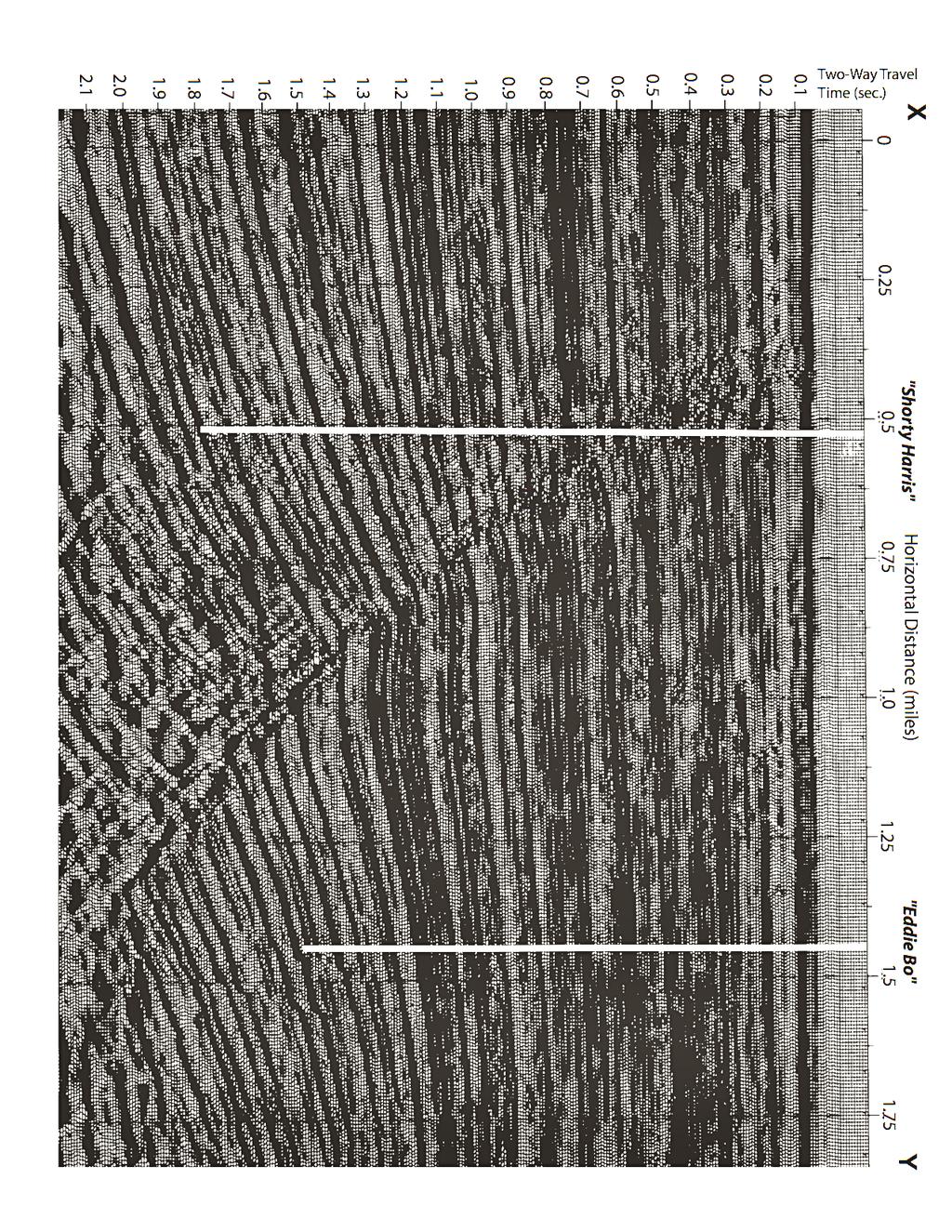
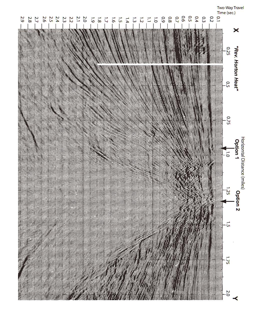
5 Seismic Line 1 1. According to the well logs, how deep are the Shorty Harris and Eddie Bo wells? 2. Using the well log data from each well and conversion calculations from the seismic data velocity model, determine where the different formation contacts are in each well. Starting at those points in each well, draw the contacts out from the well location along the seismic discontinuity that intersects the well there. Make your interpretations only as far as you can follow with certainty the discontinuity in the seismic data. Be sure to label each contact so Big Earl knows what you re trying to say. 3. Based on your interpretations, what kind of geologic structure lies between the two wells? Identify it and trace it out on the seismic data, and be sure to label it. 4. The Shorty Harris well is pumping oil from the St. Louis Fm reservoir rock. The pool it is tapping is estimated to have a million barrels of oil in it. What kind of trap allowed the oil pool to form there? Seismic Line 2 1. What does the seafloor surface in the area of your seismic line look like according to your bathymetric map? Since media with relatively higher velocities than what surrounds it look like bright spots on seismic profiles, what could the large bright structure in this profile be? Draw the outline of the structure on your profile, where the sedimentary bed reflections end against it, and label it. 2. Although the Reverend Horton Heat well gets into the St. Louis Formation reservoir rock, it is not producing oil. Using the well log and seismic data, draw the contacts of the different formations as you did on the previous profile.
6 3. Using your contact and structure interpretations above, where should you recommend that Big Earl drill for oil, at Option 1 or Option 2? Also mark that location on your bathymetry map. How deep would the well have to be to tap the St. Louis Formation? What kind of trap might be there according to your interpretations? If the oil pool at your proposed well is as estimated to be as big as that of the Shorty Harris well (question #4 above), and oil is currently selling for $25 a barrel, how much money can be made from it? Your engineers tell you that it will cost $2500 a foot to drill a well. How much did it cost to drill the unsuccessful Reverend Horton Heat well? How much will your proposed well cost to drill? Considering the cost of drilling and the unsuccessful Reverend Horton Heat well, and assuming the oil pool in your discovery is as big as that of the Shorty Harris well, will GGOC make money on your well? If so, how much? If not, at least how many barrels of oil must be in the discovery in order for the company to make a profit at current prices? What would the price of each barrel of oil have to be just to break even?
7 Well Log Data (depth below seafloor in feet) Shorty Harris Eddie Bo 1000' 1000' Rev. Horton Heat 1000' 2000' 2000' 1950' 2000' 3000' 3000' 3000' 4000' 4125' 4000' 4000' 4125' 5000' 5000' 5000' 6000' 6050' 6000' 6050' 6000' 6050' 7000' 7000' 7000' 8000' 8000' 8250' 8000' 9000' 9000' 10,000' 9900' 10,000' 9900' Bourbon Formation sandstones and shale Dauphine Formation Rock Type: Carondelet Formation Decatur Formation Rock Type: St. Louis Formation Rock Type: Rock Type:
8 225' Y Well "Eddie Bo" Seismic Line 1 Well "Shorty Harris" X 250' 275' 275' 250' Y 250' Seismic Line 2 X Well "Rev. Horton Heat" Gulf of Mexico Block 154-G bathymetric chart 2 miles
9
10
Today s oil is yesterday s plankton
 Oil and Gas Basics 2 Today s oil is yesterday s plankton Small marine and lake organisms live in surface waters They die, fall to the bottom and get buried into an organic rich sedimentary layer If geologic
Reservoirs and Production
 Lesson Plan Page 1 Topic: Reservoirs and production Topic Overview: Porosity refers to the percentage of holes (pores) in the rock. Permeability is the ability of fluids to travel through porous rocks.
Reservoirs and Production
 Lesson Plan - Page 1 Topic Reservoirs and Production Source Oil and Natural Gas, pages 24-25, 26-27 Objective The students will learn that porosity refers to the percentage of holes (pores) in the rock.
Hydrocarbon Processing Techniques
 Hydrocarbon Processing Techniques Processes and Techniques Involved in Extracting and Refining Hydrocarbons Key term: Kerogen a mixture of organic matter in sediments from which petroleum is released.
Sedimentary rocks. Mechanical Weathering. Weathering. Chemical weathering. Rates of weathering. Fossil Fuel Resources. Two kinds of weathering
 Sedimentary rocks Fossil Fuel Resources Exam next Tuesday February 14 Bring Scantron and Review Questions About 75% of all rock outcrops on the continents Important to reconstruct much of Earth's history
1. Canadian Energy Use
 1 Unit 3 Energy 2 1. Canadian Energy Use Why are Canadians the sixth highest energy users in the world? Our major industries are energy intensive, overall industry consumes 31% of all energy in Canada.
Exploration, Drilling & Production
 Nontechnical Guide to PETMOLEUM Geology, Exploration, Drilling & Production Third Edition Norman J. Hyne, Ph.D. Contents Preface *i Introduction 1 The Nature of Gas and Oil 1 Petroleum 1 The Chemistry
Lab 9: Petroleum and groundwater
 Geology 101 Name(s): Lab 9: Petroleum and groundwater Petroleum (oil) is a multi-component liquid refined to generate different hydrocarbons, such as heptane (a component of gasoline) and waxes. For the
Key Stage 3 - Volcano Fracking
 After the meeting Come out of your role. Write your own summary of the dilemmas facing the council, and recommend whether or not they should allow fracking to take place. Pupil worksheet is short for hydraulic
EAS 233 Geologic Structures and Maps Winter Miscellaneous practice map exercises. 1. Fault and separation:
 Miscellaneous practice map exercises 1. Fault and separation: With respect to Map 1, what are (a) the orientation of the fault, and (b) the orientation of bedding in the units cut by the fault. (c) Mark
PTRT 1473: Exploration and Production II. Chapter 3: Exploration
 PTRT 1473: Exploration and Production II Chapter 3: Exploration Hydrocarbon Accumulators Four conditions for hydrocarbon accumulation 1.A source rock rich in kerogen (waxy organic matter formed from buried
Geography 3202 Unit 4 S.C.O. 4.3 & 4.5. Primary Resource Activities Offshore Oil And Gas
 Geography 3202 Unit 4 S.C.O. 4.3 & 4.5 Primary Resource Activities Offshore Oil And Gas Factors Affecting The Decision To Recover Offshore Oil And Gas (4.3.1) Physical Factors 1. Ocean Related Factors
Outline 16: The Mesozoic World: Formation of Oil Deposits (with a side trip to the Devonian Marcellus Shale)
") Outline 16: The Mesozoic World: Formation of Oil Deposits (with a side trip to the Devonian Marcellus Shale) The first commercial oil well was drilled by Colonel Edwin Drake in Titusville, Pennsylvania,
Outline 16: The Mesozoic World: Formation of Oil Deposits (with a side trip to the Devonian Marcellus Shale) The first commercial oil well was drilled by Colonel Edwin Drake in Titusville, Pennsylvania,
Geology and Natural Resources
 Geology and Natural Resources Brought to you by: Western Michigan University Department of Geosciences and The Michigan Geological Repository for Research and Education s K-12 Outreach Program Core Kids
Oil & Gas. From exploration to distribution. Week 1 V05 Origin of hydrocarbon resources part 1. Jean-Pierre Deflandre
 Oil & Gas From exploration to distribution Week 1 V05 Origin of hydrocarbon resources part 1 Jean-Pierre Deflandre W1V5 Origin of hydrocarbon resources1 p. 1 Introduction to hydrocarbon resources You will
Geoscience 001 Fall Rock Identification and Contextual Interpretation
 Geoscience 00 Fall 2005 Rock Identification and Contextual Interpretation The purpose of this week s lab is to gain some more experience and practice in identifying rocks and then interpreting the geologic
Geology 101 Lab Worksheet: Geologic Time
 Geology 101 Lab Worksheet: Geologic Time Name: Refer to the Geologic Time Lab for the information you need to complete this worksheet (http://commons.wvc.edu/rdawes/g101ocl/labs/geotimelab.html). All calculations
Geologic Resources. Geologic Resources and Society. Geologic Resources and Society
 Geologic Resources Our entire society rests upon - and is dependent upon - our water, our land, our forests, and our minerals. How we use these resources influences our health, security, economy, and well-being.
ENVI.2030L Geologic Time
 Name ENVI.2030L Geologic Time I. Introduction There are two types of geologic time, relative and absolute. In the case of relative time geologic events are arranged in their order of occurrence. No attempt
Exploring and Drilling for Oil and Gas. Prepared by Tom Sheeran
 Exploring and Drilling for Oil and Gas What are Oil and Gas? Oil and Gas are substances found within the earth s crust. They are thought to come from decomposed plant and animal matter. Scientists believe
b. atomic mass H What is the density of an object with a volume of 15cm 3 and a mass of 45g?
 Name Period Date Earth Science Midterm Review 2015-2016 Quarter 1 Review Assign #1 Basic Chemistry An atom is a basic chemical building block of matter. An atom consists of protons, neutrons, and electrons.
Subsurface Mapping 1 TYPES OF SUBSURFACE MAPS:- 1.1 Structural Maps and Sections: -
 Subsurface Mapping The purpose of subsurface mapping in the geology of petroleum Is to find traps that contain oil and gas pools and the information obtained from wells forms the heart of the data upon
STUDY GUIDE FOR MID-TERM EXAM KEY. Color, luster, cleavage, fracture, hardness, taste, smell, fluorescence, radioactivity, magnetism
 STUDY GUIDE FOR MID-TERM EXAM KEY 1. In which type of rock are fossils most likely to be found? Sedimentary Rocks 2. Which mineral is easily identified by smell? Sulfur 3. Which natural resource makes
MODULE PREREQUISITES FOR HYDROCARBON ACCUMULATION
 MODULE 1 1.0 PREREQUISITES FOR HYDROCARBON ACCUMULATION The accumulation of hydrocarbons and formation of oil or gas deposit involve certain prerequisites. These are the following: 1. Source Rock 2. Reservoir
GEO 105 Oil and Gas Exploration Project
 GEO 105 Oil and Gas Exploration Project Modified from: Friedman, G.M., Johnson, K.G., 1982, Exercises in Sedimentology, John Wiley, p. 208 (via Reames and Carrigan at Olivet University) Student Learning
MULTIPLE CHOICE QUESTIONS OIL, GAS, AND PETROCHEMICALS. The Energy and Resources Institute
 MULTIPLE CHOICE QUESTIONS ON OIL, GAS, AND PETROCHEMICALS The Energy and Resources Institute Preface Petroleum as everyone knows consists of hydrocarbons of various molecular weights and other organic
sonar seismic wave basalt granite
 geologist sonar crust geology seismic wave mantle constructive force basalt inner core destructive force granite outer core The solid, rocky, surface layer of the earth. an instrument that can find objects
MIDDLE DEVONIAN PLAY MICHIGAN BASIN OF ONTARIO. Duncan Hamilton
 MIDDLE DEVONIAN PLAY MICHIGAN BASIN OF ONTARIO Duncan Hamilton 1 Middle Devonian Pools of the Michigan Basin 375+ Million Barrels Michigan 45+ million Barrels Ontario 2 Outline of Presentation History
Ocean Basins, Bathymetry and Sea Levels
 Ocean Basins, Bathymetry and Sea Levels Chapter 4 Please read chapter 5: sediments for next class and start chapter 6 on seawater for Thursday Basic concepts in Chapter 4 Bathymetry the measurement of
Topic 12: Dynamic Earth Pracatice
 Name: Topic 12: Dynamic Earth Pracatice 1. Earth s outer core is best inferred to be A) liquid, with an average density of approximately 4 g/cm 3 B) liquid, with an average density of approximately 11
Frequently Asked Questions
 Frequently Asked Questions 1 Is THERMOVISION TOMOGRAPHY technology independent, or it requires previous seismic or other data? THERMOVISION TOMOGRAPHY technology is a stand-alone technology. Independent
Answers: Internal Processes and Structures (Isostasy)
") Answers: Internal Processes and Structures (Isostasy) 1. Analyse the adjustment of the crust to changes in loads associated with volcanism, mountain building, erosion, and glaciation by using the concept
Answers: Internal Processes and Structures (Isostasy) 1. Analyse the adjustment of the crust to changes in loads associated with volcanism, mountain building, erosion, and glaciation by using the concept
Economic Geology Unconventional Energy Research
 Bureau of Economic Geology Unconventional Energy Research Overview for CEE meeting December, 2011 QAd2349x BUREAU OF ECONOMIC GEOLOGY Oldest research unit of The University of Texas at Austin Geological
PETE/GEOS 445/645 Petroleum Geology 3 credits
 PETE/GEOS 445/645 Petroleum Geology 3 credits Tuesday, Thursday 3:40-5:10 Reichardt 233 Hydrocarbons fuel today s economy, but remain a relatively rare natural resource. The objective of this course is
APPENDIX C GEOLOGICAL CHANCE OF SUCCESS RYDER SCOTT COMPANY PETROLEUM CONSULTANTS
 APPENDIX C GEOLOGICAL CHANCE OF SUCCESS Page 2 The Geological Chance of Success is intended to evaluate the probability that a functioning petroleum system is in place for each prospective reservoir. The
Sedimentary Rocks, our most Valuable Rocks. Or, what you will probably find when you are outdoors exploring.
 Sedimentary Rocks, our most Valuable Rocks Or, what you will probably find when you are outdoors exploring. Sedimentary rocks give us evidence to earth s earlier history. We look at processes happening
OIL AND GAS PLAYS OF THE MICHIGAN BASIN, SOUTHERN ONTARIO. Terry Carter, Consulting Geologist London, Ontario
 OIL AND GAS PLAYS OF THE MICHIGAN BASIN, SOUTHERN ONTARIO Terry Carter, Consulting Geologist London, Ontario 1 Ontario Petroleum Industries Oil and Natural Gas 1250 oil wells, 1200 gas wells, annual production
Lower Skinner Valley Fill Sandstones: Attractive Exploration Targets on the Northeast Oklahoma Platform*
 Lower Skinner Valley Fill Sandstones: Attractive Exploration Targets on the Northeast Oklahoma Platform* By Jim Puckette 1 Search and Discovery Article #10050 (2003) *Adapted from presentation to Tulsa
Seismic Attributes and Their Applications in Seismic Geomorphology
 Academic article Seismic Attributes and Their Applications in Seismic Geomorphology Sanhasuk Koson, Piyaphong Chenrai* and Montri Choowong Department of Geology, Faculty of Science, Chulalongkorn University,
2003 GCSSEPM Foundation Ed Picou Fellowship Grant for Graduate Studies in the Earth Sciences Recipient
 2003 GCSSEPM Foundation Ed Picou Fellowship Grant for Graduate Studies in the Earth Sciences Recipient Tarek A. El Shayeb University of Texas at Austin Integrated reservoir characterization and 3-D diagenetic
THE HOUSTON MUSEUM OF NATURAL SCIENCE ONLINE CURRICULUM WIESS ENERGY HALL 3 RD GRADE 5 TH GRADE GENEROUSLY SUPPORTED BY PWC
 THE HOUSTON MUSEUM OF NATURAL SCIENCE ONLINE CURRICULUM WIESS ENERGY HALL 3 RD GRADE 5 TH GRADE GENEROUSLY SUPPORTED BY PWC Dear Educator, Thank you for downloading the free, online curriculum available
Exploration Significance of Unconformity Structure on Subtle Pools. 1 Vertical structure characteristics of unconformity
 Exploration Significance of Unconformity Structure on Subtle Pools Wu Kongyou (China University of Petroleum,College of Geo-Resources and Information,Shandong Qingdao 266555) Abstract: Vertical structure
ROCKS OF THE LAKE CAYUGA BASIN, NEW YORK
 Bedrock Correlation Name: Introduction: The Finger Lakes Region of New York State is underlain by rocks of Devonian Age. Use your reference tables to determine the types of rocks that outcrop around the
THIS IS A NEW SPECIFICATION
 THIS IS A NEW SPECIFICATION ADVANCED GCE GEOLOGY Environmental Geology F794 * OCE / 12441* Candidates answer on the Question Paper OCR Supplied Materials: None Other Materials Required: Electronic calculator
Groundwater Hydrology
 EXERCISE 12 Groundwater Hydrology INTRODUCTION Groundwater is an important component of the hydrologic cycle. It feeds lakes, rivers, wetlands, and reservoirs; it supplies water for domestic, municipal,
Tuesday 11 June 2013 Afternoon
 Tuesday 11 June 2013 Afternoon A2 GCE GEOLOGY F794/01 Environmental Geology *F713190613* Candidates answer on the Question Paper. OCR supplied materials: None Other materials required: Electronic calculator
AGENDA HIGHT LIGHT OF INDONESIA EXPLORATION ACTIVITY BACKGROUND
 AGENDA Background - Hight Light of Indonesia Exploration Activity - Obstacles - Exploration Opportunity - Exploration Strategy Definition - Exploration Incentives - New Field NELLI EKAYANTI New Field Determining
Lecture Outline Friday March 2 thru Wednesday March 7, 2018
 Lecture Outline Friday March 2 thru Wednesday March 7, 2018 Questions? Lecture Exam Friday March 9, 2018 Same time, Same room Bring Pencils and WSU ID 50 question Multiple Choice, Computer Graded Interlude
Marine Science and Oceanography
 Marine Science and Oceanography Marine geology- study of the ocean floor Physical oceanography- study of waves, currents, and tides Marine biology study of nature and distribution of marine organisms Chemical
Block 43B - Onshore Oman
 Block 43B - Onshore Oman SUMMARY Block 43B is an 11,967 km 2 area located along the coastal area of Oman north of the Hajar Mountains. This is an unexplored region, both geographically and stratigraphically.
WESTCARB Phase I Results Review
 WESTCARB Phase I Results Review Arizona Geologic Characterization Errol Montgomery Principal Errol L. Montgomery & Associates (520) 881-4912 emontgomery@elmontgomery.com November 9, 2005 Site Characterization
OTC OTC PP. Abstract
 OTC OTC-19977-PP Using Modern Geophysical Technology to Explore for Bypassed Opportunities in the Gulf of Mexico R.A. Young/eSeis; W.G. Holt, G. Klefstad/ Fairways Offshore Exploration Copyright 2009,
B.C. s Offshore Oil and Gas: a Guide to the Geology and Resources.
 B.C. s Offshore Oil and Gas: a Guide to the Geology and Resources. Introduction Beneath the offshore regions of British Columbia are four moderately large, geologically young sedimentary basins (Figure
Ground-Water Exploration in the Worthington Area of Nobles County: Summary of Seismic Data and Recent Test Drilling Results
 Ground-Water Exploration in the Worthington Area of Nobles County: Summary of Seismic Data and Recent Test Drilling Results Jim Berg and Todd Petersen Geophysicists, DNR Waters January 2000 Table of Contents
RAYMOND SIEVER Harvard University
 E A R T H FOURTH EDITION FRANK PRESS National Academy of Sciences RAYMOND SIEVER Harvard University W. H. Freeman and Company New York Preface xiii Acknowledgments xviii PART I PROLOGUE CHAPTER 1 HISTORY
Risk Analysis Methods
 Economic Risk and Decision Analysis for Oil and Gas Industry CE81.9008 School of Engineering and Technology Asian Institute of Technology January Semester Presented by Dr. Thitisak Boonpramote Department
Feasibility and design study of a multicomponent seismic survey: Upper Assam Basin
 P-276 Summary Feasibility and design study of a multicomponent seismic survey: Upper Assam Basin K.L.Mandal*, R.K.Srivastava, S.Saha, Oil India Limited M.K.Sukla, Indian Institute of Technology, Kharagpur
3/8/2012. Wood chemical energy stored by plants Kinetic energy Water power Wind Fossil fuels Alternatives Solar Plant derivatives Nuclear
 Wood chemical energy stored by plants Kinetic energy Water power Wind Fossil fuels Alternatives Solar Plant derivatives Nuclear http://www.dkimages.com/discover/home/s cience/physics-and-chemistry/sound-and-
Fossil Fuels, Chemistry of Fuels
 Fossil Fuels, Chemistry of Fuels Energy sources Wood chemical energy stored by plants Kinetic energy Water power to grind grain Wind to pump water Fossil fuels http://www.dkimages.com/discover/home/sc
Example Quiz on Earthquakes
 Example Quizzes, Tests, and Review Information A Example Quiz on Earthquakes Quizzes such as this one are given at the beginning of each lab. 1. The point beneath the Earth s surface at which an earthquake
Tim Carr - West Virginia University
 Tim Carr - West Virginia University Elements Source Rock Migration Route Reservoir Rock Seal Rock Trap Processes Generation Migration Accumulation Preservation 2 Reservoir Porous & Permeable Rock Suitable
Topics: The Layers of the Earth and its Formation Sources of Heat Volcanos and Earthquakes Rock Cycle Rock Types Carbon Tax
 Topics: The Layers of the Earth and its Formation Sources of Heat Volcanos and Earthquakes Rock Cycle Rock Types Carbon Tax Essay Question on Carbon Tax 1. Drilling 2. Volcanic Activity 3. Laboratory experiments
Name: Date: Use the following to answer question 2.
 Name: Date: 1. Which of the following statements regarding the scientific method is false? A) A hypothesis must be agreed upon by more than one scientist. B) A theory is a hypothesis that has withstood
So I have a Seismic Image, But what is in that Image?
 P-513 So I have a Seismic Image, But what is in that Image? Dr. Nader C. Dutta, Schlumberger Introduction and background Migration involves repositioning of returned signals in a seismic experiment to
MUHAMMAD S TAMANNAI, DOUGLAS WINSTONE, IAN DEIGHTON & PETER CONN, TGS Nopec Geological Products and Services, London, United Kingdom
 Geological and Geophysical Evaluation of Offshore Morondava Frontier Basin based on Satellite Gravity, Well and regional 2D Seismic Data Interpretation MUHAMMAD S TAMANNAI, DOUGLAS WINSTONE, IAN DEIGHTON
Petroleum Exploration
 Petroleum Exploration Upstream Petroleum Exploration The role of exploration is to provide the information required to exploit the best opportunities presented in the choice of areas, and to manage research
Your web browser (Safari 7) is out of date. For more security, comfort and. the best experience on this site: Update your browser Ignore
 is out of date. For more security, comfort and. the best experience on this site: Update your browser Ignore") Your web browser (Safari 7) is out of date. For more security, comfort and Activitydevelop the best experience on this site: Update your browser Ignore Extracting Gas from Shale How is natural gas extracted
Your web browser (Safari 7) is out of date. For more security, comfort and Activitydevelop the best experience on this site: Update your browser Ignore Extracting Gas from Shale How is natural gas extracted
Tim Carr - West Virginia University
 GEOGRAPHIC EXTENT OF PETROLEUM SYSTEM A Trap Trap Trap A STRATIGRAPHIC EXTENT OF PETROLEUM SYSTEM Petroleum accumulation Top of oil window Bottom of oil window Overburden Seal Reservoir Source Underburden
GEOL 3700 STRUCTURE AND TECTONICS LABORATORY EXERCISE 3
 GEOL 3700 STRUCTURE AND TECTONICS LABORATORY EXERCISE 3 Goals: 1. Improve your map-reading and map-making skills. 2. Learn to generate and interpret structure contour maps. 3. Learn to generate and interpret
Vail et al., 1977b. AAPG 1977 reprinted with permission of the AAPG whose permission is required for further use.
 Well 5 Well 4 Well 3 Well 2 Well 1 Vail et al., 1977b AAPG 1977 reprinted with permission of the AAPG whose permission is required for further use. Well 5 Well 4 Well 3 Well 2 Well 1 Vail et al., 1977b
 12 10 8 6 4 2 0 40-50 50-60 60-70 70-80 80-90 90-100 Fresh Water What we will cover The Hydrologic Cycle River systems Floods Groundwater Caves and Karst Topography Hot springs Distribution of water in
Chapter 3 Natural Gas Basics
 Chapter 3 Natural Gas Basics Chapter 3 Natural Gas Basics This chapter briefly describes basic theories and terminology used within the report i.e., it briefly describes what natural gas is, how it is
Trapping Mechanisms along North Similan and Lanta Trends, Pattani Basin, Gulf of Thailand
 Trapping Mechanisms along North Similan and Lanta Trends, Pattani Basin, Gulf of Thailand Piyaporn Aukkanit Petroleum Geoscience Program, Department of Geology, Faculty of Science, Chulalongkorn University,
ES Chap 5 & 6: Rocks
 ES Chap 5 & 6: Rocks Objectives 1. Identify and explain characteristics of igneous rocks. This means that if I am given an igneous rock I: a. Can use grain size to identify a rock as intrusive, extrusive,
Earth Revealed #1: Down to Earth Answer the following questions. Please take additional notes as you watch the program.
 Earth Revealed #1: Down to Earth Name Answer the following questions. Please take additional notes as you watch the program. 1. The Earth has two Heat Engines. What drives the Earth s internal heat engine?
Rockall Plateau. OCN 201: Shelf Sediments
 Rockall Plateau OCN 201: Shelf Sediments Classification by Mode of Formation Detrital sediments Transported and deposited as particles Derived from weathering of pre-existing rocks (igneous, metamorphic
Angel International School - Manipay 1 st Term Examination November, 2015
 Grade 08 Angel International School - Manipay 1 st Term Examination November, 2015 Chemistry Duration: 2 Hours Index No:- Underline the correct answer. 1. Which of the following is a fossil fuel? a) Natural
Write It! Station Directions
 Write It! Write It! Station Directions It is recommended that you have completed at least two of the following stations before working at this station. -Read It! -Explore It! -Watch It! -Research It! Answer
Rock Cycle. Draw the Rock cycle on your remediation page OR use a sheet of notebook paper and staple
 Earth Science Test 8.ESS2.3) Describe the relationship between the processes and forces that create igneous, sedimentary, and metamorphic rocks. I can develop and use models to explain how plate movements
1. minerals - A naturally occurring substance that takes a solid Crystal form and is made of only a single (one) type of compound
 type of compound") Science Name: Mr. G/Mrs. Kelly KEY Date: Study Guide - Lessons 5 and 6 Test Define the following terms: 1. minerals - A naturally occurring substance that takes a solid Crystal form and is made of only
Science Name: Mr. G/Mrs. Kelly KEY Date: Study Guide - Lessons 5 and 6 Test Define the following terms: 1. minerals - A naturally occurring substance that takes a solid Crystal form and is made of only
Biostratigraphic and Lithostratigraphic Correlation of Sedimentary Strata in the Atlantic Coastal Plain
 Biostratigraphic and Lithostratigraphic Correlation of Sedimentary Strata in the Atlantic Coastal Plain Introduction to the Atlantic Coastal Plain (Please read this page prior to doing the lab) The Atlantic
Monday 2 June 2014 Morning
 Monday 2 June 2014 Morning A2 GCE GEOLOGY F794/01 Environmental Geology *3076922876* Candidates answer on the Question Paper. OCR supplied materials: None Other materials required: Electronic calculator
Risk Factors in Reservoir Simulation
 Risk Factors in Reservoir Simulation Dr. Helmy Sayyouh Petroleum Engineering Cairo University 12/26/2017 1 Sources Of Data Petro-physical Data Water saturation may be estimated from log analysis, capillary
Seismic stratigraphy, some examples from Indian Ocean, interpretation of reflection data in interactive mode
 Seismic stratigraphy, some examples from Indian Ocean, interpretation of reflection data in interactive mode K. S. Krishna National Institute of Oceanography, Dona Paula, Goa-403 004. krishna@nio.org Seismic
Small area of the ocean that is partially surrounded by land. The Ocean Basins. Three Major Oceans. Three Major Oceans. What is a SEA?
 The Ocean Basins How Deep is the Ocean? 1 2 Three Major Oceans Three Major Oceans Pacific Atlantic the shallowest ocean (3.3km average depth) Indian second shallowest ocean (3.8km average depth) Pacific
Western Kentucky CO 2 Storage Test
 Western Kentucky CO 2 Storage Test Principal Investigators: Rick Bowersox - Lexington Dave Williams - Henderson KGS First Friday Seminar Lexington, Kentucky March 4, 2011 The project proceeded in two phases:
Chapter 6 Sedimentary and Metamorphic Rock
 Chapter 6 Sedimentary and Metamorphic Rock Weathering and Erosion Wherever rock is exposed at Earth s surface, it is continuously being broken down by weathering a set of physical and chemical processes
List the layers of the Earth and provide a short description of each layer starting with the center of the Earth.
 Why does the Earth have different layers? List the layers of the Earth and provide a short description of each layer starting with the center of the Earth. How is density related to the layers of the Earth?
(1) Identify 5 major principles of relative dating? For each principle, describe how you tell what is younger and what is older.
 Identify 5 major principles of relative dating? For each principle, describe how you tell what is younger and what is older.") Things to Know - Third GLG101Exam Page 1 Important Note: This is not everything you need to know or study. However, it provides you with a relatively comprehensive list of questions to help you study.
Things to Know - Third GLG101Exam Page 1 Important Note: This is not everything you need to know or study. However, it provides you with a relatively comprehensive list of questions to help you study.
The Rock Cycle & Plate Tectonics
 The Rock Cycle & Plate Tectonics I. The Rock Cycle 1. Rocks are the most common material on Earth. 2. They are made up of one or more minerals. A. The rock cycle explains how Earth processes change a rock
F794. GEOLOGY Environmental Geology ADVANCED GCE. Friday 10 June 2011 Afternoon
 ADVANCED GCE GEOLOGY Environmental Geology F794 *F711210611* Candidates answer on the question paper. OCR supplied materials: None Other materials required: Electronic calculator Ruler (cm/mm) Friday 10
1. In the block diagram shown here, which is the oldest rock unit?
 Pre/Post GCI Name (print) 1. In the block diagram shown here, which is the oldest rock unit? 2. Referring to the same diagram as the previous question, which of the labeled rock units is the youngest?
Dr. Kenneth B. Taylor, P.G.
 North Carolina Forestry Association 2013 Annual Meeting October 3, 2013 Shale Gas 101: Natural Gas Exploration / Development: A North Carolina Perspective presented by Dr. Kenneth B. Taylor, P.G. State
Maximize the potential of seismic data in shale exploration and production Examples from the Barnett shale and the Eagle Ford shale
 Maximize the potential of seismic data in shale exploration and production Examples from the Barnett shale and the Eagle Ford shale Joanne Wang, Paradigm Duane Dopkin, Paradigm Summary To improve the success
Education Days Moscow Closing Session
 Education Days Moscow 2013 Basin and Petroleum Systems Modelling: Applications for Conventional and Unconventional Petroleum Exploration Risk and Resource Assessments By Dr Bjorn Wygrala Schlumberger 21-22
Seismic interpretation of gas hydrate based on physical properties of sediments Summary Suitable gas hydrate occurrence environment Introduction
 based on physical properties of sediments Zijian Zhang* 1,2 and De-hua Han 2 1 AOA Geophysics, Inc. and 2 Rock Physics Lab, University of Houston Summary This paper analyzes amplitude behavior of gas hydrate
Hydrocarbon Volumetric Analysis Using Seismic and Borehole Data over Umoru Field, Niger Delta-Nigeria
 International Journal of Geosciences, 2011, 2, 179-183 doi:10.4236/ijg.2011.22019 Published Online May 2011 (http://www.scirp.org/journal/ijg) Hydrocarbon Volumetric Analysis Using Seismic and Borehole
GLY3160 / PHY3160 Introduction to Geophysics
 GLY3160 / PHY3160 Introduction to Geophysics What is geophysics? Comes in two* basic flavors *(your text says three) Pure (academic) geophysics Studying various Earth processes from a physics approach.
EGAS. Ministry of Petroleum
 EGAS Ministry of Petroleum EGAS Ministry of Petroleum About The Block Location: N. El Arish offshore block is located in the extreme eastern part of the Egypt s economic water border and bounded from the