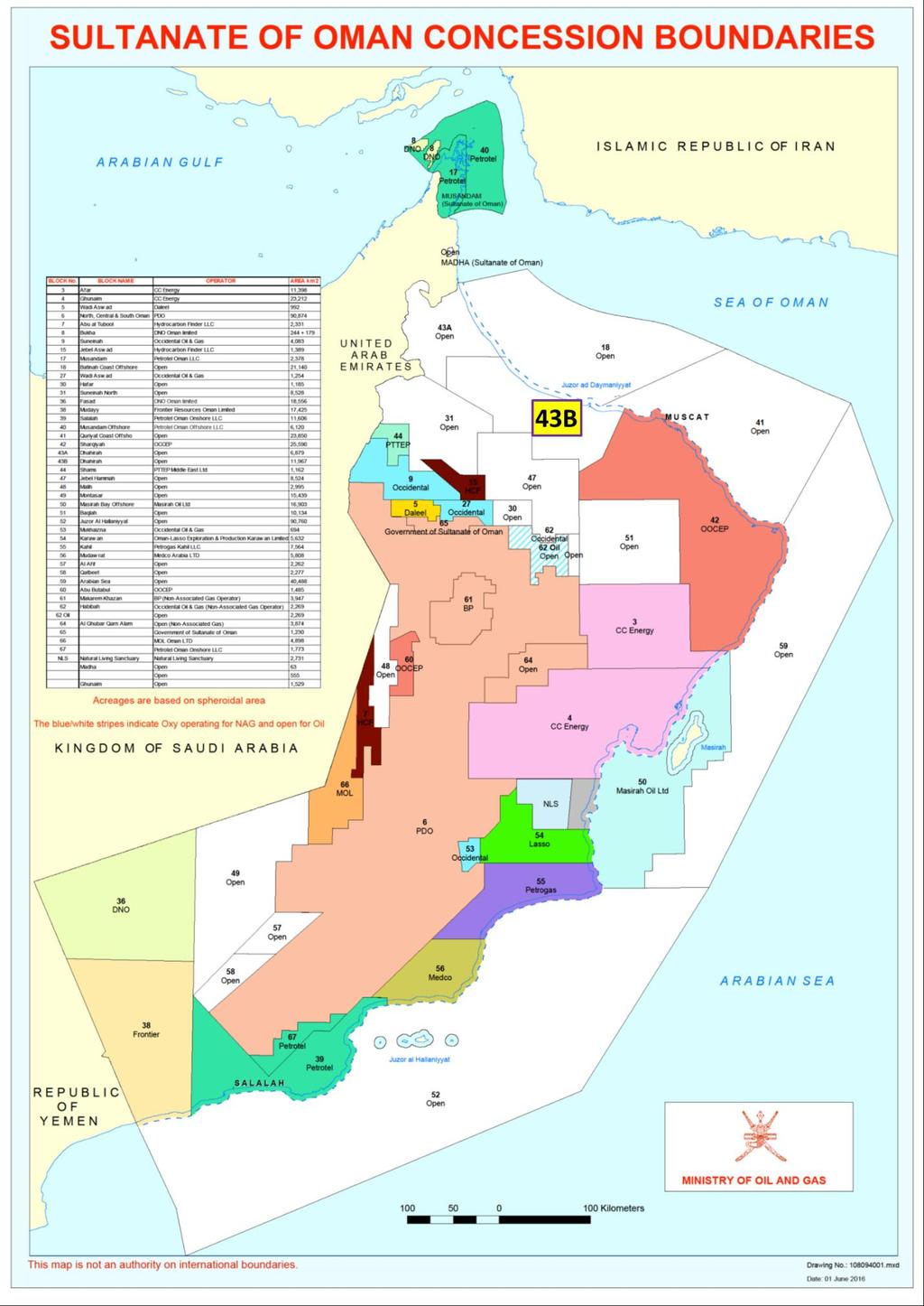
Block 43B - Onshore Oman
|
|
|
- Gilbert Hancock
- 5 years ago
- Views:
Transcription
1 Block 43B - Onshore Oman SUMMARY Block 43B is an 11,967 km 2 area located along the coastal area of Oman north of the Hajar Mountains. This is an unexplored region, both geographically and stratigraphically. Block 43B has time-equivalent formations with the interior of Oman but these have not been explored in any depth. The known formations located in the block are well-displayed in outcrop. Those that are the most likely reservoirs are thick and comparable in rock properties to oil-bearing formations in the interior of Oman. In the subsurface within the block these potential reservoir rocks have had gas shows. Conventional gas is the main play type across the block. Oil is also possible since this block s burial was not as deep as those to its south. While there have been no discoveries (only two wells have been drilled here) there are several prospects mapped across the block. 1
2 2
3 BLOCK OWNERSHIP HISTORY Over its history Block 43B has had several owners, the primary ones being Petroleum Development (Oman) and Amoco. Other companies which have owned this block are: Hawasina, LLC MOL Only two wells have been drilled. The first was drilled in 1985 by Amoco: the Barka-1. The last well, the Hawasina-1, was drilled by MOL. The last owner of the block was MOL. AVAILABLE DATA 1,200 km of 2D seismic data Block seismic base map, satellite image map and infrastructure map Gravity data Data for two wells Seismic and well location base map STRATIGRAPHY 3
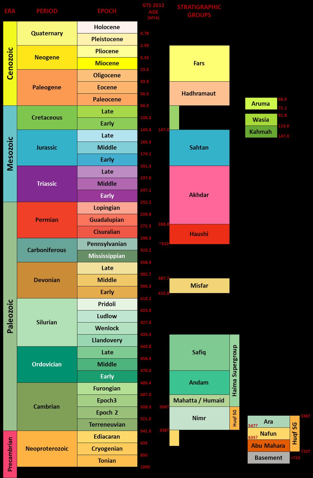
4 Oman chronostratigraphic chart (GTS 2012 dates incorporated) 4


5 The stratigraphic section that occurs within this block is predominated by Tertiary age carbonates and clastics. The Eocene and Paleocene formations are the most significant potential reservoirs. The Miocene through Pleistocene section has a complex stratigraphic architecture. This section is potential reservoir. The Campanian age Al Khwad Formation is a possible reservoir. From a chronostratigraphic point of view the section within Block 43B is equivalent to the post-fars, Fars, Hadhramaut and Aruma groups. Stratigraphic column for Block 43B 5


6 Stratigraphic relationships for Block 43B. The base of the Al Khwad Formation is an unconformity. In some areas this formation may sit directly upon ophiolites, as shown here. Based on outcrop and seismic analyses the entire stratigraphic section from Campanian through Holocene is characterized by numerous unconformities. These are directly related to two controlling factors: Post-Cretaceous structuring due to tectonic plate interactions. Sea level variations due to Tertiary age glacial episodes. In addition to the unconformities the block covers the northern platform edges for several thick intervals. Vertical build-ups and progradational clinoforms occur along these edges. Platform-edge mounding and clinoforms within the Seeb Formation. OUTCROP AND ANALOGS The Maastrichtian through Holocene sedimentary section is accessible and well-exposed in the mountains around Muscat. These provide a clear representation of the overall lithologies 6
7 and stratigraphic successions expected to occur within the block. The specific formations that outcrop around Muscat are: Undifferentiated Holocene, Pleistocene and Pliocene sediments Seeb Formation Rusayl Formation Jafnayn Formation Al Khwad The outcrop belts extend to Wadi Tiwi, westward along the coast from Muscat. DISCOVERIES There have been no discoveries within the block. Gas shows were encountered throughout the carbonate units in the Barka-1. PROSPECTS Several prospects have been mapped within the Seeb Formation. These occur along the coastal portion of the block. PLAY SUMMARY Conventional gas is the main play type across the block. Oil is also possible since this block s burial was not as deep as those to its south. TRAP Predominantly 2-way dip-closed, fault-bounded anticlines. Stratigraphic traps associated with reefs have been identified in adjacent blocks and are expected to occur within this block. Platform-edge mounding and progradation are visible on seismic within the block (see previous figure). Elsewhere in Oman, such as in the Natih and Shuaiba formations, such geometries result in successful stratigraphic traps. 7

8 SW to NE seismic line (4BAR-06/08) illustrating structure. Evidence of thrusting visible as are antithetics which create fault-bounded closures. RESERVOIR Reservoirs include stable, shelf limestones in the Seeb and Jafnayn formations, sandstones and conglomerates in Pliocene through Holocene deposits and limestone-dominated clastics in the Pliocene and Pleistocene deposits. Clastics in the Al Khwad Formation may also be of reservoir quality. The Seeb and Jafnayn formations have good reservoir quality with high porosity as well as permeability. SEAL Locally seals within the limestone units are probably thin but continuous shales/marls. On a more regional scale shaly units within the Rusayl Formation, marls within the Jafnayn and Seeb formations and Batinah Group marls and shales could serve as effective seals. The potential sealing intervals are visible in outcrop and contribute to the overall flat-iron patterns in the mountains near Muscat. SOURCE 8
9 The Early Eocene rocks are considered a primary source. Paleocene and Maastrichtian rocks may also contain source rocks. Numerous possible migration pathways exist along bedding and faults. MOVING FORWARD Proceeding further takes you out of the public area. Doing so gives you access to the raw data as well as the ability to order interpretation-ready and evaluation packages. There are 4 steps for moving forward. Step 1: MEERA Subscription for the bid round MEERA is the software platform being used by the MOG. It allows users to view data live and interactively from anywhere in the world. For more information on this platform please view the LDR video. The subscription permits general access and allows viewing of the data packages. The system is the official point of contact with the MOG and will be used for Interaction with the MOG, including clarification requests. Bid submissions Award notifications Step 2: MOG raw data viewing and purchase These data can be viewed live from anywhere in the world via the MEERA platform. Acquiring the raw data is simple. These data can be downloaded directly or can be provided on digital media for a selected destination. There is a large amount of raw data for this block. These data include seismic lines, well documents and gravity data. Following is a brief summary listing for seismic and well data. Seismic data: Results from 11 2D surveys in segy. BHP90BA: 19 lines MOL06REG1: 26 lines MOL06REG3: 3 lines MOL07REG1: 175 lines MOL08REG1: 219 lines MOL10YNQ1: 39 lines MOL11YNQ1: 6 lines REP11MA_1: 5 lines REP11MA_2: 4 lines SDO96BA_1: 39 lines 9
10 UNK50BA_2: 16 lines Those surveys possessing a high number of lines may contain a smaller number of total lines which have been processed in several ways. Well Data: Not all wells contain the same types of data. Most have log data and many have a series of well documents. Some wells also have core data. Barka-1 Hawasina-1 Step 3: Target Oilfield Services interpretation-ready package viewing and purchase Target Oilfield Services has prepared an interpretation-ready Petrel project. The Petrel project contains all seismic data and MOG raw well data. Step 4: Target Oilfield Services evaluation package viewing and purchase Target Oilfield Services has completed a comprehensive block interpretation. This interpretation has rectified data errors and inconsistencies. It places the block within a regional context and incorporates Target's extensive knowledge of Oman's geology and reservoirs. Intended to aid in block analysis the evaluation package provides a significant advantage to anyone trying to assess this block. The evaluation package for Block 43B contains the following. A geological evaluation report for the block. o Reviews and updates/corrects stratigraphy across the block. o Contains a sedimentological study for the entire Fars through Huqf interval. o Reviews and provides details on the geologic structures within the block. o identifies existing and additional prospects within the block. Well log data o Edited, spliced and QC log files for wells o Interpreted logs for wells Fault interpretations of the 2D seismic data for the following horizons. o Miocene Unconformity o Top Oligocene o Top Seeb Formation o Top Jafnayn Formation Multi-horizon TWT and depth interpretations of the 2D seismic data. o Miocene Unconformity o Top Oligocene o Top Seeb Formation o Top Jafnayn Formation 10
11 Data are in digital format and can be provided as: o Downloadable data in standard digital formats. o A complete Petrel project containing the wells, well logs, seismic data and interpretations. o A complete Kingdom project containing the wells, well logs, seismic data and interpretations. MINISTRY INFORMATION When available the standard MOG data to be provided include: All 2D and 3D seismic data within the block boundaries Gravity data associated with the block Well files for all wells in the block (note: these may not exist for all wells) Cultural data: Infrastructure, etc. Surface topography maps Contact: Suleiman Saif Al Ghuniami Director of Petroleum Concessions Ministry of Oil and Gas Tel Fax s.alghunaimi@mog.gov.om TARGET OILFIELD SERVICES INFORMATION Contact: ldrsupport@targetofs.com 11
Block 65 - Onshore Oman
 Block 65 - Onshore Oman SUMMARY Block 65 is a 1,230 km 2 area located in the interior of Oman. Over its history Block 65 has had several owners and it has also experienced several configuration changes.
EGAS. Ministry of Petroleum
 EGAS Ministry of Petroleum EGAS Ministry of Petroleum About The Block Location: N. Thekah offshore block is located at about 56 km to the north of the Mediterranean shore line, 85 km to the north west
EGAS. Ministry of Petroleum
 EGAS Ministry of Petroleum EGAS Ministry of Petroleum About The Block Location: N. El Arish offshore block is located in the extreme eastern part of the Egypt s economic water border and bounded from the
APPENDIX C GEOLOGICAL CHANCE OF SUCCESS RYDER SCOTT COMPANY PETROLEUM CONSULTANTS
 APPENDIX C GEOLOGICAL CHANCE OF SUCCESS Page 2 The Geological Chance of Success is intended to evaluate the probability that a functioning petroleum system is in place for each prospective reservoir. The
BALOCHISTAN FOLDBELT BASIN
 INTRODUCTION BALOCHISTAN FOLDBELT BASIN The Kharan-3 block is located in the Kharan Trough of Balochistan Basin. GEOLOGICAL SETTING The Balochistan Province is an Upper Cretaceous to Recent structurally
MUHAMMAD S TAMANNAI, DOUGLAS WINSTONE, IAN DEIGHTON & PETER CONN, TGS Nopec Geological Products and Services, London, United Kingdom
 Geological and Geophysical Evaluation of Offshore Morondava Frontier Basin based on Satellite Gravity, Well and regional 2D Seismic Data Interpretation MUHAMMAD S TAMANNAI, DOUGLAS WINSTONE, IAN DEIGHTON
Hydrocarbon Potential of the Marginal Fields in Niger Delta Oza Field, a case study*
 Hydrocarbon Potential of the Marginal Fields in Niger Delta Oza Field, a case study* J.N. Sahu 1, C.H.V. Satya Sai 1, V. Chintamani 1 and C. Vishnu Vardhan 1 Search and Discovery Article #20182 (2012)*
Ministry of Oil and Minerals Petroleum Exploration & Production Authority BLOCK 80 (WADI SARR)
") Ministry of Oil and Minerals Petroleum Exploration & Production Authority BLOCK 80 (WADI SARR) The Wadi Sarr Block (80) occupies an area of 1961 km 2 on the Sayun- Masilah Basin in the central Yemen. Block
Ministry of Oil and Minerals Petroleum Exploration & Production Authority BLOCK 80 (WADI SARR) The Wadi Sarr Block (80) occupies an area of 1961 km 2 on the Sayun- Masilah Basin in the central Yemen. Block
Integrated well log and 3-D seismic data interpretation for the Kakinada area of KG PG offshore basin
 IOSR Journal of Applied Geology and Geophysics (IOSR-JAGG) e-issn: 2321 0990, p-issn: 2321 0982.Volume 5, Issue 4 Ver. II (Jul. Aug. 2017), PP 01-05 www.iosrjournals.org Integrated well log and 3-D seismic
For personal use only
 PNG Company Number 1-63551 Kina Petroleum Forward Exploration & Farmout Program in the Eastern and Western Papuan Basin December 2016 Slide 1 Kina s Assets straddle the stable Platform of the Western Papuan
Petroleum geology framework, West Coast offshore region
 Petroleum geology framework, West Coast offshore region James W. Haggart* Geological Survey of Canada, Vancouver, BC jhaggart@nrcan.gc.ca James R. Dietrich Geological Survey of Canada, Calgary, AB and
Overview of Mozambique Digital Atlas MOZDA. MOZDA 2014 Release
 Overview of Mozambique Digital Atlas MOZDA MOZDA 2014 Release MOZDA 2014 - Mozambique Digital Atlas A regional framework of Mozambique Wells, Headers, Formation Tops, Seismic Stratigraphic Framework Key
Blocks 31, 32, 33, 34, 35 & 36/03 Southeast Offshore Vietnam
 Blocks 31, 32, 33, 34, 35 & 36/03 Southeast Offshore Vietnam Block 31 32 33 34 35 36/03 Area (km 2) 5,036 4,440 4,630 4,700 4,630 2,950 Sea level (m) 20 20-30 30-40 50 50 50 Seismic 2D (km) 1,294 685 431
Chapter 3. Geology & Tectonics
 Chapter 3 Geology & Tectonics 3.1 Geology The general geological features of Indonesia are shown in Figure 3.1. The basement formation is metamorphic and it is intruded with plutonic formations. They are
Debra K. Gomez 1 and David Brewster 2. Search and Discovery Article #10843 (2016)** Posted March 21, Abstract
** Posted March 21, Abstract") PS Petroleum Potential Onshore Southern Madagascar, Morandava Basin, Block 3114* Debra K. Gomez 1 and David Brewster 2 Search and Discovery Article #10843 (2016)** Posted March 21, 2016 *Adapted from poster
PS Petroleum Potential Onshore Southern Madagascar, Morandava Basin, Block 3114* Debra K. Gomez 1 and David Brewster 2 Search and Discovery Article #10843 (2016)** Posted March 21, 2016 *Adapted from poster
RELINQUISHMENT REPORT. License P1546 Block April 2009
 RELINQUISHMENT REPORT License P1546 Block 110-01 14 April 2009 Sherritt International Oil and Gas Limited 2000, 425-1 st street S.W., Calgary, Alberta Canada T2P 3L8 Telephone (403) 260-2900 Fax (403)
Biostratigraphic and Lithostratigraphic Correlation of Sedimentary Strata in the Atlantic Coastal Plain
 Biostratigraphic and Lithostratigraphic Correlation of Sedimentary Strata in the Atlantic Coastal Plain Introduction to the Atlantic Coastal Plain (Please read this page prior to doing the lab) The Atlantic
A.K. Khanna*, A.K. Verma, R.Dasgupta, & B.R.Bharali, Oil India Limited, Duliajan.
 P-92 Application of Spectral Decomposition for identification of Channel Sand Body in OIL s operational area in Upper Assam Shelf Basin, India - A Case study A.K. Khanna*, A.K. Verma, R.Dasgupta, & B.R.Bharali,
Subsurface Geology and Resource Exploration
 LAB 11. Subsurface Geology and Resource Exploration Locating earth resources such as aluminum, copper, gold and gemstones has been an important job for geologists for a long time. This lab deals with the
F.H. NADER 1, PETROLEUM SYSTEMS MODELING CHALLENGES OF STRUCTURALLY COMPLEX FRONTIER BASINS: THE CASE OF THE LEVANT (EAST-MED) BASIN
 BASIN") PETROLEUM SYSTEMS MODELING CHALLENGES OF STRUCTURALLY COMPLEX FRONTIER BASINS: THE CASE OF THE LEVANT (EAST-MED) BASIN A PROPOSED INTEGRATED APPROACH F.H. NADER 1, J. Barabasch 2, L. Inati 1, M. Ducros
PETROLEUM SYSTEMS MODELING CHALLENGES OF STRUCTURALLY COMPLEX FRONTIER BASINS: THE CASE OF THE LEVANT (EAST-MED) BASIN A PROPOSED INTEGRATED APPROACH F.H. NADER 1, J. Barabasch 2, L. Inati 1, M. Ducros
OIL INDIA LIMITED, GEOPHYSICS DEPARTMENT, DULIAJAN, ASSAM.
 J. P. Singh, M. K. Gupta & Akshaya Kumar, Oil India Limited, Duliajan. jpsingh@oilindia.in Summary Oil exploration in Upper Assam commenced with the discovery of the Digboi oilfield more than 100 years
ONSHORE / OFFSHORE & NEW SHALE POTENTIAL OF MOROCCO
 Kingdom of Morocco ONSHORE / OFFSHORE & NEW SHALE POTENTIAL OF MOROCCO Mr M. NAHIM Mrs N. ESSALLOUMI Key aspects of Morocco Political and economic stability; Economic policy of integration at regional
BACK TO BASICS WHY THE TORRES BASIN COULD BE A COMPANY MAKER Papua New Guinea :PPL326 A Frontier Basin
 BACK TO BASICS WHY THE TORRES BASIN COULD BE A COMPANY MAKER Papua New Guinea :PPL326 A Frontier Basin 1 Tertiary Carbonate/Clastic Prospects and Leads PNG_LNG Facility PPL326 has a large number of over
RELINQUISHMENT REPORT FOR LICENCE P.1663, BLOCK 29/4b and 29/5e
 RELINQUISHMENT REPORT FOR LICENCE P.1663, BLOCK 29/4b and 29/5e Licence: P.1663 Blocks: 29/4b & 29/5e 25th Round Traditional Licence Operator: Ithaca Energy UK(Ltd) 100% Work Programme Summary The agreed
Perspectives from Offshore Argentina & Uruguay
 Perspectives from Offshore Argentina & Uruguay A Prospectivity Overview Hannah Kearns October 2018 Introduction Argentina Offshore License Round 1 14 blocks Argentina North, 24 Austral-Malvinas Offshore
Oil and Gas Potential in Interior Alaska
 Oil and Gas Potential in Interior Alaska http://www.dog.dnr.state.ak.us/oil Robert F. Swenson, Deputy Director State of Alaska Department of Natural Resources Division Geological & Geophysical Surveys
Ministry of Oil and Minerals Petroleum Exploration & Production Authority BLOCK 85 (Al Uqlah North)
") Ministry of Oil and Minerals Petroleum Exploration & Production Authority BLOCK 85 (Al Uqlah North) The Al Uqlah North Block (85) occupies an area of 597 km 2 in the Sabatayn Basin in the province of Shabwah
Ministry of Oil and Minerals Petroleum Exploration & Production Authority BLOCK 85 (Al Uqlah North) The Al Uqlah North Block (85) occupies an area of 597 km 2 in the Sabatayn Basin in the province of Shabwah
Petroleum Systems (Part One) Source, Generation, and Migration
 Source, Generation, and Migration") Petroleum Systems (Part One) Source, Generation, and Migration GEOL 4233 Class January 2008 Petroleum Systems Elements Source Rock Migration Route Reservoir Rock Seal Rock Trap Processes Generation Migration
Petroleum Systems (Part One) Source, Generation, and Migration GEOL 4233 Class January 2008 Petroleum Systems Elements Source Rock Migration Route Reservoir Rock Seal Rock Trap Processes Generation Migration
REGIONAL GEOLOGY IN KHMER BASIN
 CONTENTS 1-Khmere Basin 2-Regional Geology Khmer Basin 3-Regime Tectonic 4-Seismic Database -a/ Acquisition Data -b/ Prospect Angkor -C/ Cross Section Seismic 5-Play Type -a/ Play Schematic -b/ Structure
Supplementary Material for Eighty million years of folding migration: new perspective on the Syrian Arc from Levant basin analysis
 GSA Data Repository 2018040 https://doi.org/10.1130/g39654.1 Supplementary Material for Eighty million years of folding migration: new perspective on the Syrian Arc from Levant basin analysis Sagy Yael,
ANGOLA OFFSHORE LICENSING 2007 BLOCK 46
 AGOLA OFFHOR LICIG 2007 BLOCK 46 DATA BA AVAILABILITY Figure 1 shows the seismic data available on Block 46. Fig. 1 Commercial 2D surveys: esterngeco: 794 km. GX Technology: 116 km. Commercial 3D surveys:
Jordan. Target Exploration. Target Exploration
 Page1 barr Target Exploration Target Exploration barr Target Exploration Target Exploration Petroleum Potential of Wadi Sirhan Basin Jordan Petroleum Potential of Wadi Sirhan Basin, Jordan Sequence Stratigraphy,
Exploration, Drilling & Production
 Nontechnical Guide to PETMOLEUM Geology, Exploration, Drilling & Production Third Edition Norman J. Hyne, Ph.D. Contents Preface *i Introduction 1 The Nature of Gas and Oil 1 Petroleum 1 The Chemistry
Ministry of Oil and Minerals Petroleum Exploration & Production Authority BLOCK 6 (Iryam)
") Ministry of Oil and Minerals Petroleum Exploration & Production Authority BLOCK 6 (Iryam) The Iryam Block (6) occupies an area of 3,911 km 2 in the Sabatayn Basin in the province of Shabwah in central
Ministry of Oil and Minerals Petroleum Exploration & Production Authority BLOCK 6 (Iryam) The Iryam Block (6) occupies an area of 3,911 km 2 in the Sabatayn Basin in the province of Shabwah in central
RWE Dea UK SNS Limited (50%), Faroe Petroleum (UK) Limited
, Faroe Petroleum (UK) Limited") 1. Licence information Licence Number P1975 Licence Round 27 th (2012) Licence Type Traditional Blocks 3/28c & 9/3e Licensees Work Programme 2. Synopsis RWE Dea UK SNS Limited (50%), Faroe Petroleum (UK)
1. Licence information Licence Number P1975 Licence Round 27 th (2012) Licence Type Traditional Blocks 3/28c & 9/3e Licensees Work Programme 2. Synopsis RWE Dea UK SNS Limited (50%), Faroe Petroleum (UK)
P1645 Fig 1: Licence P1645 Introduction
 Licence Number: P.1645 commenced 12 th November 2008 Licence Round: 25 th Licence Type: Traditional Block Number: 9/8b Operator: EnQuest (60%) Partners: Norwegian Energy Company (Noreco) UK Ltd 40% Work
Sequence Stratigraphy. Historical Perspective
 Sequence Stratigraphy Historical Perspective Sequence Stratigraphy Sequence Stratigraphy is the subdivision of sedimentary basin fills into genetic packages bounded by unconformities and their correlative
The map The ma (Somaliland ( Somaliland Somalia) SOMALIA SOMALILAND
 SOMALIA SOMALILAND") SOMALILAND COUNTRY BACKGROUND & HYDROCARBON POTENTIAL MINISTRY OF WATER & MINERAL RESOURCES PRESENTATION OUTLINE Introduction Petroleum Geology Petroleum Regulations & PSC Model Re-sizing of Blocks Current
SOMALILAND COUNTRY BACKGROUND & HYDROCARBON POTENTIAL MINISTRY OF WATER & MINERAL RESOURCES PRESENTATION OUTLINE Introduction Petroleum Geology Petroleum Regulations & PSC Model Re-sizing of Blocks Current
Relinquishment Report
 Relinquishment Report Licence P1403 Block 13/22d Chevron North Sea Limited Korean National Oil Company Chevron North Sea Limited December 2009 1 SYNOPSIS... 3 2 INTRODUCTION. 3 2.1 Licence Terms.. 3 2.2
Implications of the Rabat Deep 1 exploration well on the prospectivity of the surrounding area
 Transformational Growth Through Exploration Implications of the exploration well on the prospectivity of the surrounding area Morocco Brazil Namibia South Atlantic 100 Ma Reconstruction Growth through
P1488 DECC Relinquishment Report OMV (U.K.) Ltd.
 Ltd.") 1. Synopsis: P1488 DECC Relinquishment Report OMV (U.K.) Ltd. UK offshore Licence P1488 was awarded to OMV, Dana Petroleum and Rocksource in the 24 th Licence Round on the 24 th of January 2007 as a frontier
1. Synopsis: P1488 DECC Relinquishment Report OMV (U.K.) Ltd. UK offshore Licence P1488 was awarded to OMV, Dana Petroleum and Rocksource in the 24 th Licence Round on the 24 th of January 2007 as a frontier
Licence P1368: Relinquishment Report (end of 2 nd term) Hurricane Exploration PLC
 Hurricane Exploration PLC") Licence P1368: Relinquishment Report (end of 2 nd term) Hurricane Exploration PLC March 2012 1. Header Licence Number: P1368 Licence Round: 23 rd Licence Type: Frontier Block Numbers: 202/4, 202/5, 204/30,
Licence P1368: Relinquishment Report (end of 2 nd term) Hurricane Exploration PLC March 2012 1. Header Licence Number: P1368 Licence Round: 23 rd Licence Type: Frontier Block Numbers: 202/4, 202/5, 204/30,
PETROLEUM GEOSCIENCES GEOLOGY OR GEOPHYSICS MAJOR
 PETROLEUM GEOSCIENCES GEOLOGY OR GEOPHYSICS MAJOR APPLIED GRADUATE STUDIES Geology Geophysics GEO1 Introduction to the petroleum geosciences GEO2 Seismic methods GEO3 Multi-scale geological analysis GEO4
PETROLEUM GEOLOGY OF THE RUSSIAN FAR-EAST
 Contents - 1 PETROLEUM GEOLOGY OF THE RUSSIAN FAR-EAST CONTENTS PART I: INTRODUCTION TO THE RUSSIAN FAR EAST AND ITS STRUCTURAL DEVELOPMENT. Chapter 1. The Russian Far East: Introduction and Infrastructure.
Blocks offered in Sri Lanka s Second Licensing Round
 Blocks offered in Sri Lanka s Second Licensing Round Sri Lankan Main Basins Cauvery Basin Cauvery Deep Water sub-basin Mannar Basin 2 Structural Framework Sri Lanka Basins Cauvery & Mannar Basins were
Application of fault seal Analysis, Buselli field, Onshore Nile Delta, Egypt
 P Application of fault seal Analysis, Buselli field, Onshore Nile Delta, Egypt 1 M. Y. Zein El-Din P P, Nabil Abdel Hafez P and Osama Mahrous P 2 3 Professor of petroleum exploration, Geology department,
Shallow Gas Prospect Evaluation in Shahbazpur Structure Using Seismic Attributes Analysis - a Case Study for Bhola Island, Southern Bangladesh
 Dhaka Univ. J. Sci. 64(2): 135-140, 2016 (July) Shallow Gas Prospect Evaluation in Shahbazpur Structure Using Seismic Attributes Analysis - a Case Study for Bhola Island, Southern Bangladesh Morshedur
1. LICENCE INFORMATION. P209 Block 9/29a ALL. U.K. Block 9/29a (Part Block) Operator/Partners TAQA Bratani Ltd 81%, RWE DEA UK 19%
 Operator/Partners TAQA Bratani Ltd 81%, RWE DEA UK 19%") 1. LICENCE INFORMATION Licence P209 Block 9/29a ALL Licence Round 4th round Blocks U.K. Block 9/29a (Part Block) Licence Type Traditional (Production) Well Operator TAQA Bratani Ltd Operator/Partners TAQA
1. LICENCE INFORMATION Licence P209 Block 9/29a ALL Licence Round 4th round Blocks U.K. Block 9/29a (Part Block) Licence Type Traditional (Production) Well Operator TAQA Bratani Ltd Operator/Partners TAQA
Dalhousie University- Petroleum Geoscience Field Methods- Trinidad Summary Report
 Dalhousie University- Petroleum Geoscience Field Methods- Trinidad Summary Report Submitted to: Offshore Energy Research Association of Nova Scotia (OERA) To fulfill requirements of the Undergraduate Student
Geologic influence on variations in oil and gas production from the Cardium Formation, Ferrier Oilfield, west-central Alberta, Canada
 Geologic influence on variations in oil and gas production from the Cardium Formation, Ferrier Oilfield, west-central Alberta, Canada Marco Venieri and Per Kent Pedersen Department of Geoscience, University
Figure 1: Location and bathymetry of the study area. Gulf of Guinea. Cameroon. Congo. Gabon. PGS/DGH Gabon MegaSurvey Coverage (35000Km 2 ) Eq.
 Eq.") Deepwater hydrocarbon prospectivity analysis of offshore North and South Gabon Muhammad S Tamannai (*), Thomas Hansen (1), Ron Borsato (1), Jennifer Greenhalgh (1) Martial-Rufin Moussavou (2) & Landry
Deepwater hydrocarbon prospectivity analysis of offshore North and South Gabon Muhammad S Tamannai (*), Thomas Hansen (1), Ron Borsato (1), Jennifer Greenhalgh (1) Martial-Rufin Moussavou (2) & Landry
Hydrocarbon plays of the Mid North Sea High: an integrated seismic and basin modelling study
 Hydrocarbon plays of the Mid North Sea High: an integrated seismic and basin modelling study Stephen Corfield, Julian Moore, Maurice Bamford, Andrew Barnwell and Patrick Barnard -OGA Frontier exploration
KENYA ONSHORE, LAMU BASIN Block L14 FARM- IN OPPORTUNITY
 KENYA ONSHORE, LAMU BASIN Block L14 FARM- IN OPPORTUNITY Lamu Oil and Gas, a joint venture between QFB and Edgo Energy, is seeking one or more partners, to continue exploration of their highly attractive
Results of Preliminary Study of Shale Gas and Shale Oil Perspectives in Georgia
 World Experience in Shale Oil & Gas Industry and prospects of its Development in Georgia Results of Preliminary Study of Shale Gas and Shale Oil Perspectives in Georgia By: Archil Magalashvili Murman Margvelashvili
Depositional History and Petroleum Potential of Ombilin Basin, West Sumatra - Indonesia, Based on Surface Geological Data*
 Depositional History and Petroleum Potential of Ombilin Basin, West Sumatra - Indonesia, Based on Surface Geological Data* Yahdi Zaim 1, Litto Habrianta 2, Chalid I. Abdullah 1, Aswan 1, Yan Rizal 1, Nurcahyo
A comparison of structural styles and prospectivity along the Atlantic margin from Senegal to Benin. Peter Conn*, Ian Deighton* & Dario Chisari*
 A comparison of structural styles and prospectivity along the Atlantic margin from Senegal to Benin Overview Peter Conn*, Ian Deighton* & Dario Chisari* * TGS, Millbank House, Surbiton, UK, KT6 6AP The
Relinquishment Report. Licence P2016 Block 205/4c
 Relinquishment Report Licence P2016 Block 205/4c September 2016 JX Nippon Exploration and Production (U.K.) Limited Idemitsu Petroleum UK Ltd. Table of Contents 1. Licence Information... 1 2. Licence Synopsis...
All permissions to publish have been obtained (see Section 9)
") 1. Licence Information Licence Number: P1741 Licence Round: 26 th Round Licence Type: Traditional Block Numbers: 42/13b, 42/17 & 42/18 All permissions to publish have been obtained (see Section 9) 2. Licence
1. Licence Information Licence Number: P1741 Licence Round: 26 th Round Licence Type: Traditional Block Numbers: 42/13b, 42/17 & 42/18 All permissions to publish have been obtained (see Section 9) 2. Licence
BERG-HUGHES CENTER FOR PETROLEUM AND SEDIMENTARY SYSTEMS. Department of Geology and Geophysics College of Geosciences
 BERG-HUGHES CENTER FOR PETROLEUM AND SEDIMENTARY SYSTEMS Department of Geology and Geophysics College of Geosciences MISSION Integrate geoscience, engineering and other disciplines to collaborate with
THE NORTH SUMATERA BASIN : GEOLOGICAL FRAMEWORK & PETROLEUM SYSTEM REVIEW
 THE NORTH SUMATERA BASIN : GEOLOGICAL FRAMEWORK & PETROLEUM SYSTEM REVIEW By the Delegation of Indonesia : Bambang Wicaksono TM* Jonathan Setyoko H* Hermes Panggabean** * Lemigas ** PSG Krabi, 12-15 May
Relinquishment Report. for. Licences: P.1596 (Blocks 205/3, 205/4a) P.1836 (Block 205/2b) P.1837 (Block 205/5b)
 P.1836 (Block 205/2b) P.1837 (Block 205/5b)") Relinquishment Report for Licences: P.1596 (Blocks 205/3, 205/4a) P.1836 (Block 205/2b) P.1837 (Block 205/5b) November 2013 1 of 9 CONTENT 1. Header 2. Synopsis 3. Exploration Activities 4. Prospectivity
Relinquishment Report for Licences: P.1596 (Blocks 205/3, 205/4a) P.1836 (Block 205/2b) P.1837 (Block 205/5b) November 2013 1 of 9 CONTENT 1. Header 2. Synopsis 3. Exploration Activities 4. Prospectivity
Reservoir Modelling of a Bioclastic Calcarenite Complex on Favignana, Southern Italy: The Application of Multi-point Statistics*
 Reservoir Modelling of a Bioclastic Calcarenite Complex on Favignana, Southern Italy: The Application of Multi-point Statistics* Robert Kil 1 and Andrea Moscariello 2,3 Search and Discovery Article #50548
Managing Oil & Gas Exploration Risk in the Kurdistan Region of Iraq
 Managing Oil & Gas Exploration Risk in the Kurdistan Region of Iraq Simon Hatfield Chief Executive Officer WesternZagros Resources Limited World Independent & Junior Oil and Gas Congress, London, UK September
GEOLOGY MEDIA SUITE Chapter 8
 UNDERSTANDING EARTH, SIXTH EDITION GROTZINGER JORDAN GEOLOGY MEDIA SUITE Chapter 8 Clocks in Rocks Timing the Geologic Record 2010 W.H. Freeman and Company Stratigraphy and fossils Figure 8.4 (page 172)
Serica Energy (UK) Limited. P.1840 Relinquishment Report. Blocks 210/19a & 210/20a. UK Northern North Sea
 Limited. P.1840 Relinquishment Report. Blocks 210/19a & 210/20a. UK Northern North Sea") Serica Energy (UK) Limited P.1840 Relinquishment Report Blocks 210/19a & 210/20a UK Northern North Sea January 2013 1 Header Licence: P.1840 Round: Licence Type: 26th Round Traditional "Drill-or-Drop"
Serica Energy (UK) Limited P.1840 Relinquishment Report Blocks 210/19a & 210/20a UK Northern North Sea January 2013 1 Header Licence: P.1840 Round: Licence Type: 26th Round Traditional "Drill-or-Drop"
Licence Relinquishment Report. P.1400 Block 12/30. First Oil Expro Ltd
 Licence Relinquishment Report P.1400 Block 12/30 First Oil Expro Ltd December 2007 Seaward Production Licence P.1400, Block 12/30 Block 12/30 was awarded 100% to Reach Exploration North Sea Ltd as a promote
ELECTRICAL RESISTIVITY IMAGING FOR QUATERNARY AQUIFER IN WADI MURAYKHAT AND WADI SA A, AL AIN AREA, UAE.
 ELECTRICAL RESISTIVITY IMAGING FOR QUATERNARY AQUIFER IN WADI MURAYKHAT AND WADI SA A, AL AIN AREA, UAE. By: Ahmed. El-Mahmoudi KFU University, Water Studies Centre, KSA Figure (#) Map of Al Jaww Plain
Relinquishment Report for Licence P.1265, Block 12/28
 Relinquishment Report for Licence P.1265, Block 12/28 1. Licence Information Licence Number: P.1265 Licence Round: 23 rd Round Awarded 22 December 2005 Licence Type: Traditional Block Number(s): 12/28
petroleum exploration You are an exploration team in charge of a new petroleum province Your task is to get maximum return on investment (ROI)
") Purpose: Enhance your overall understanding of petroleum exploration Multidisciplinary challenge You are an exploration team in charge of a new petroleum province Your task is to get maximum return on
Purpose: Enhance your overall understanding of petroleum exploration Multidisciplinary challenge You are an exploration team in charge of a new petroleum province Your task is to get maximum return on
A Preliminary Geophysical Reconnaissance Mapping of Emirau Ground Water Resource, Emirau Island, New Ireland Province, PNG
 A Preliminary Geophysical Reconnaissance Mapping of Emirau Ground Water Resource, Emirau Island, New Ireland Province, PNG Geological Survey Division of Mineral Resources Authority (MRA) Papua New Guinea
Imprints of Mesozoic-Paleozoic strata and Eocene Carbonates in J&K Sub-Himalaya : Potential Rocks for Hydrocarbon Exploration
 6 th International Conference & Exposition on Petroleum Geophysics Kolkata 2006 Imprints of Mesozoic-Paleozoic strata and Eocene Carbonates in J&K Sub-Himalaya : Potential Rocks for Hydrocarbon Exploration
Stratigraphic Plays in Active Margin Basin: Fluvio-Deltaic Reservoir Distribution in Ciputat Half Graben, Northwest Java Basin*
 Stratigraphic Plays in Active Margin Basin: Fluvio-Deltaic Reservoir Distribution in Ciputat Half Graben, Northwest Java Basin* Ary Wahyu Wibowo 1, Astri Pujianto 1, Wisnu Hindadari 1, Arief Wahidin Soedjono
Thickness, Compositional and Textural Variability, and Genesis of El-Lajjun Oil Shale, Central Jordan
 Thickness, Compositional and Textural Variability, and Genesis of El-Lajjun Oil Shale, Central Jordan H Alnawafleh 1, D Large 2 & B Spiro 3 1 Department of Mining Engineering, Al-Hussein Bin Talal University,
Regional Paleogeography and Implications for Petroleum Prospectivity, Taranaki Basin, New Zealand*
 Regional Paleogeography and Implications for Petroleum Prospectivity, Taranaki Basin, New Zealand* Dominic P. Strogen 1, Kyle J. Bland 1, Jan R. Baur 1,2, and Peter R. King 1 Search and Discovery Article
Sedimentary Cycle Best Practice: Potential Eo-Oligocene Sediments in Western Indonesia*
 Sedimentary Cycle Best Practice: Potential Eo-Oligocene Sediments in Western Indonesia* Mellinda Arisandy 1 and I Wayan Darma 1 Search and Discovery Article #11008 (2017)** Posted November 6, 2017 *Adapted
IRAQ. Target Exploration. Geodynamic Evolutions of The Sedimentary Basins of. This study is a major reference for Petroleum
 barr Target Exploration Target Exploration Geodynamic Evolutions of The Sedimentary Basins of IRAQ This study is a major reference for Petroleum Explorationists on the tectonics, stratigraphy, sedimentary
Bulletin of Earth Sciences of Thailand. Evaluation of the Petroleum Systems in the Lanta-Similan Area, Northern Pattani Basin, Gulf of Thailand
 Evaluation of the Petroleum Systems in the Lanta-Similan Area, Northern Pattani Basin, Gulf of Thailand Sirajum Munira Petroleum Geoscience Program, Department of Geology, Faculty of Science, Chulalongkorn
Luderitz Basin, Offshore Namibia: Farm-out Opportunity. APPEX, London, March 2015 Graham Pritchard, Serica Energy plc
 Luderitz Basin, Offshore Namibia: Farm-out Opportunity APPEX, London, March 2015 Graham Pritchard, Serica Energy plc Serica Luderitz Basin Namibia Introduction Serica (85%, operator) 17,384 km 2 acreage
Petroleum Potential of the Application Area L12-4
 Petroleum Potential of the Application Area L12-4 The Application Area (L12-4) is underlain by the western Officer Basin, beneath the Gunbarrel Basin. The general basin architecture is outlined in Figure
Seismic stratigraphy, some examples from Indian Ocean, interpretation of reflection data in interactive mode
 Seismic stratigraphy, some examples from Indian Ocean, interpretation of reflection data in interactive mode K. S. Krishna National Institute of Oceanography, Dona Paula, Goa-403 004. krishna@nio.org Seismic
RELINQUISHMENT REPORT. UK Traditional Licence P Blocks 12/16b & 12/17b. First Oil Expro Limited (Operator, 46.67%)
") RELINQUISHMENT REPORT UK Traditional Licence P.1887 Blocks 12/16b & 12/17b First Oil Expro Limited (Operator, 46.67%) Nautical Petroleum Limited (26.67%) North Sea Energy (UK NO2) Limited (26.67%) February
RELINQUISHMENT REPORT UK Traditional Licence P.1887 Blocks 12/16b & 12/17b First Oil Expro Limited (Operator, 46.67%) Nautical Petroleum Limited (26.67%) North Sea Energy (UK NO2) Limited (26.67%) February
Distribution of Overpressure and its Prediction in Saurashtra Dahanu Block, Western Offshore Basin, India*
 Distribution of Overpressure and its Prediction in Saurashtra Dahanu Block, Western Offshore Basin, India* Kanak R. Nambiar 1, B.K. Singh 2, R.N. Goswami 2, and K.R.K. Singh 2 Search and Discovery Article
Abstract. Introduction. Regional Setting. GCSSEPM to be published December 2003
 Shelf Margin Deltas and Associated Deepwater Deposits: Implications on Reservoir Distribution and Hydrocarbon Entrapment, Block VI-1, Ulleung Basin, East Sea, South Korea Sneider, John S. Sneider Exploration,
Understanding Earth Fifth Edition
 Understanding Earth Fifth Edition Grotzinger Jordan Press Siever Chapter 5: SEDIMENTATION: Rocks Formed by Surface Processes Lecturer: H Mohammadzadeh Assistant professors, Department of Geology, FUM Copyright
Hydrocarbon Exploration in Morocco: Current Activities and Opportunities. H. Jabour
 Hydrocarbon Exploration in Morocco: Current Activities and Opportunities H. Jabour O N H Y M February 06, 2013 Outline Background Hydrocarbon potential of Morocco Non-Conventional Hydrocarbon Resources
Case Study of the Structural and Depositional-Evolution Interpretation from Seismic Data*
 Case Study of the Structural and Depositional-Evolution Interpretation from Seismic Data* Yun Ling 1, Xiangyu Guo 1, Jixiang Lin 1, and Desheng Sun 1 Search and Discovery Article #20143 (2012) Posted April
EGAS. Ministry of Petroleum and Mineral Resources EGAS
 EGAS 5 8 7 6 2 1 3 Block Summary Location: North Ras El Esh Offshore Block is located in the shallow waters of the Mediterranean Sea, at the outlet of Damietta Branch of the River Nile. The southern boundary
Bulletin of Earth Sciences of Thailand. A study of Reservoir Connectivity in the Platong Field, Pattani Basin, Gulf of Thailand. Hathairat Roenthon
 A study of Reservoir Connectivity in the Platong Field, Pattani Basin, Gulf of Thailand Hathairat Roenthon Petroleum Geoscience Program, Department of Geology, Faculty of Science, Chulalongkorn University,
2D Seismic Interpretation and Well Log Analysis of Missakaswal Area, Upper Indus Basin, Pakistan
 2D Seismic Interpretation and Well Log Analysis of Missakaswal Area, Upper Indus Basin, Pakistan Urooj Shakir 1, Muyyassar Hussain 2, Rida Azhar 1, Anum Zafar 1, Snodia Asghar 1, Muhammad Raiees Amjad
UKCS License P th Round Traditional Carrizo Oil & Gas, Inc. (operator) 100%
 100%") Block 22/8a Relinquishment Report UKCS License P.1797 26 th Round Traditional Carrizo Oil & Gas, Inc. (operator) 100% March 2015 Estimates, statistics, opinions and forecasts contained in this document
Block 22/8a Relinquishment Report UKCS License P.1797 26 th Round Traditional Carrizo Oil & Gas, Inc. (operator) 100% March 2015 Estimates, statistics, opinions and forecasts contained in this document
Prospectivity of the Equatorial Conjugate Margins of Africa and South America
 Prospectivity of the Equatorial Conjugate Margins of Africa and South America Ron Borsato* 1, Jennifer Greenhalgh 1, Steve Wells 1, Rick Roberson 1, Carlos Fontes 2 1 PGS, 2 Geohub Contents Introduction
Geothermal exploration in a sedimentary basin: new continuous temperature data and physical rock properties from northern Oman
 https://doi.org/10.1186/s40517-018-0091-6 RESEARCH Open Access Geothermal exploration in a sedimentary basin: new continuous temperature data and physical rock properties from northern Oman Felina Schütz
GEO4240: 3D Seismic Interpretation Project
 GEO4240: 3D Seismic Interpretation Project STRUCTURAL GEOLOGY PROJECT: Jura reservoir in the Troll Field (block 31/2) Phase 1: Geological framework (study key literature). Interpret 2D seismic line SG8043-402
Figure 1: PEDL 155 Location Map
 Licence Details UK Onshore Licence PEDL 155 October 2014 Licence Number: PEDL 155 Licence Round: UK 12 th Onshore Licensing Round Effective Date: 1 October 2004 Licence Type: Petroleum Exploration and
Meandering Miocene Deep Sea Channel Systems Offshore Congo, West Africa
 Meandering Miocene Deep Sea Channel Systems Offshore Congo, West Africa S. Baer* (PGS), J. E. Comstock (PGS), K. Vrålstad (PGS), R. Borsato (PGS), M. Martin (PGS), J.P. Saba (SNPC), B. Débi-Obambé (SNPC)
Building for the Future with Global Knowledge and Dedicated Skills. Jan Maier North Africa Capital Markets Day
 Building for the Future with Global Knowledge and Dedicated Skills Jan Maier North Africa 1 Core Plays: Recent and Current Exploration in North Africa Sirte Basin Matruh Basin CORE PLAYS Fold Belts Rift
NAME HOMEWORK ASSIGNMENT #3 MATERIAL COVERS CHAPTERS 8, 9, 10, 11
 NAME HOMEWORK ASSIGNMENT #3 MATERIAL OVERS HAPTERS 8, 9, 10, 11 Assignment is due the beginning of the class period on November 23, 2004. Answers for each chapter will be discussed in class, as Exam #3
Hydrocarbon Volumetric Analysis Using Seismic and Borehole Data over Umoru Field, Niger Delta-Nigeria
 International Journal of Geosciences, 2011, 2, 179-183 doi:10.4236/ijg.2011.22019 Published Online May 2011 (http://www.scirp.org/journal/ijg) Hydrocarbon Volumetric Analysis Using Seismic and Borehole
EAS 233 Geologic Structures and Maps Winter Miscellaneous practice map exercises. 1. Fault and separation:
 Miscellaneous practice map exercises 1. Fault and separation: With respect to Map 1, what are (a) the orientation of the fault, and (b) the orientation of bedding in the units cut by the fault. (c) Mark
ALPHA GOLD PROJECT 1
 ALPHA GOLD PROJECT 1 Alpha Gold Project Over 1,000 acre property targeting the intersection of the 50 Moz Cortez Gold Trend and the regional scale Pine Valley Garden Valley anticline Anticlinal Crest preserved