PTRT 1473: Exploration and Production II. Chapter 3: Exploration
|
|
|
- Kenneth Thomas
- 5 years ago
- Views:
Transcription
1 PTRT 1473: Exploration and Production II Chapter 3: Exploration
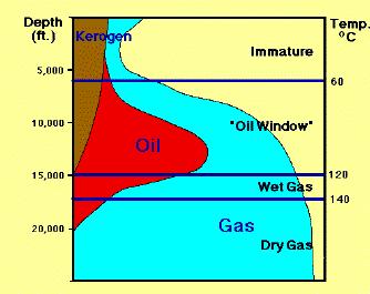
2 Hydrocarbon Accumulators Four conditions for hydrocarbon accumulation 1.A source rock rich in kerogen (waxy organic matter formed from buried plants and animals); 2.Kerogen buried deep enough for ground heat and pressure to cook it into oil in source rock (maturation); 3.There must be a porous and permeable reservoir rock to migrate and accumulate it; 4.a cap rock (seal) that prevents the hydrocarbon from escaping to the surface.
 are mixed and deposited together. They are not going to decay like those left on surface of land.")
3 Source Rock Source rock: generates natural gas or crude oil Oil and gas are formed from ancient organic matter (dead plants and animals) preserved in sedimentary rocks Organic matter, mineral grains (sands and mud) are mixed and deposited together. They are not going to decay like those left on surface of land. When ocean organic matter (algae, spores, pollen, bacteria) is buried as kerogen, it is transformed into crude oil. Shales make up about 75% of all sedimentary rocks; shale is the most common source rock; about 90% of kerogen is found in shales; Black shale: 1-20% organic matter; Green shale: about 0.5% Dark limestones are also source rocks (N. Africa, Middle East) Dark limestone
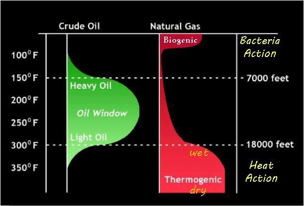
4 Generation Temperature is the most important factor in generation of crude oil from organic matter in sedimentary rocks Minimum 150 F; maximum about 300 F for oil generation Biogenic gas formed by bacteria action at shallow depth where T< 150; Biogenic gas (mostly methane) also known as swamp gas is not trapped Thermogenic gas is generated and trapped at depth where T>300F; when T>300F, crude oil is converted to graphite (C) and natural gas Oil window is usually from about 7000 to ft deep; can extend to ft in areas such as Gulf of Mexico where thermal gradient is low Oil is originally generated as good with API gravity of Bacteria and physical and chemical processes degrade good oil to form heavy oil Maturity is the degree of oil generation in source rock; 30-60% of buried organic matter generates oil

5 Maturation It is the process of biological, physical and chemical alteration of kerogen into petroleum; Source rocks that experience the right conditions for these processes and can generate petroleum are termed mature. Maturation begins with a series of low-temperature reactions that involve anaerobic bacteria reduce the oxygen, nitrogen and sulphur in the kerogen, leading to an increased concentration of hydrocarbon compounds; this stage continues until the source rock reaches about 50 C. Significant amounts of petroleum only begin to form at temperatures over 50 C (122 F) and the largest quantity of petroleum is formed as the kerogen is heated to temperatures between 65 and 150 C ( F). At still higher temperatures oil becomes thermally unstable and breaks down to natural gas. Even after maturation, some of the kerogen still remains unaltered as a carbon-rich residue.
6

7 100 o F Crude Oil Natural Gas Biogenic Bacteria 150 o F 200 o F 250 o F Heavy Oil Oil Window 7000 ft 300 o F Light Oil wet Heat ft 350 o F 400 o F Thermogenic dry
8
9 Depth (ft) Temperature Gradient of Earth s Crust Temperature (F)

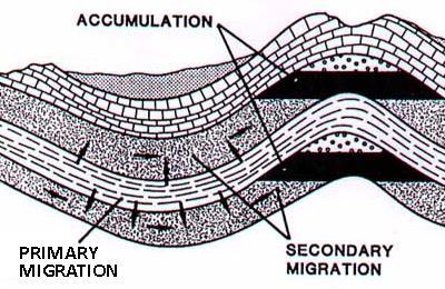
10 Migration Volume is increased dramatically when solid organic matter has been transformed into liquid crude oil or nature gas Large expansion of volume brings stresses which fracture the rock Hydrocarbons escape through the fractures; fractures close after Oil and gas flow upward along faults, fractures and permeable rock Carrier beds: very permeable rock layers that transmit fluids. If there is a trap along the migration route, the hydrocarbon can accumulate in the trap and form a reservoir. Only 10% of hydrocarbon formed is trapped; the rest stayed in the source rock, was lost during migration, or seeped into the earth s surface. Thermogenic gas cannot be found at shallow depths; Exp. Oil has migrated 200 miles horizontally out from the source area in the Williston basin of Montana
: movement out from source")
: from reservoir to")
11 Primary and Secondary Migration Primary Migration (1): movement out from source rock to reservoir rock Secondary Migration (2): from reservoir to accumulation
12

13 Accumulation Once gas and oil migrate into the trap, they separate according to density; gas goes to the top, oil goes to the middle, saltwater goes to the bottom Saturated pool: three phases coexist. Gas on top is saturated, reaches equilibrium state with oil phase; the oil phase has dissolved the maximum natural gas it can hold and is saturated Unsaturated pool: only oil exist in reservoir, it dissolved all the gas and can hold more, therefore is unsaturated Gas reservoir: only gas exist in reservoir


14 Reservoir Rock Sandstone Sandstone is sand grains (made up mostly of quartz) cemented together; quartz (silica) is one of the most abundant minerals on earth ; The grain size of sandstone is 1/16 to 2 mm in diameter; Sandstones make up about 11% of all sedimentary rocks It is the most common reservoir rock; porous and more permeable than carbonate reservoirs Well sorted sandstone (clean sands) are usually in light color. Carbonates Carbonates are made primarily of calcium carbonate; the most common source of carbonates is the shells of marine organisms Limestone is the most common carbonate rock; Carbonates comprise of about 13% of all sedimentary rocks Carbonates are brittle; they are often fractured; Fractured carbonates are prolific reservoir rocks with high permeability Carbonates like dark limestones can as well be good source rocks
")


15 Traps Structural Trap Traps created due to deformation (folds and faults) of sedimentary rock layers; there must be an impermeable caprock Stratigraphic Trap Traps created due to deposition irregularities, such as unconformities and facies; in this facie, the shale prevents the oil from escaping the trap

16 Angular unconformities Secondary Stratigraphic Traps


17 Sealing fault Anticline and domes are often cut by faults Fault can form a barrier to flow - seal If fault is a sealing fault, elevation of oil must be different in both reservoirs Many faults in deltas and coastal areas are sealing faults Domes Individual salt domes often have multiple traps Example: Bay Marchand salt dome in New Orleans has over 125 producing reservoirs
18 Geophysical Petroleum Exploration

 is taken as the freefall acceleration of an object at sea level at a latitude of 45.5 and is 980.665 cm/s 2 (or equivalently 9.80665 m/s 2 ); standard gravity is therefore 980.")
19 Geophysical Methods of Exploration Gravity Surveys Gravity data provide a better understanding of the subsurface geology It s a relatively cheap, non-invasive, non-destructive remote sensing method No need of energy to operate in order to acquire data The objective in exploration work is to associate variations with differences in the distribution of densities and hence rock types Variations in gravity on the surface of the Earth are very small; so, units for gravity surveys are generally in milligals (mgal) where 1 mgal is one thousandth of 1cm/s 2 Standard gravity ( g n or g 0 ) is taken as the freefall acceleration of an object at sea level at a latitude of 45.5 and is cm/s 2 (or equivalently m/s 2 ); standard gravity is therefore Gal or mgal
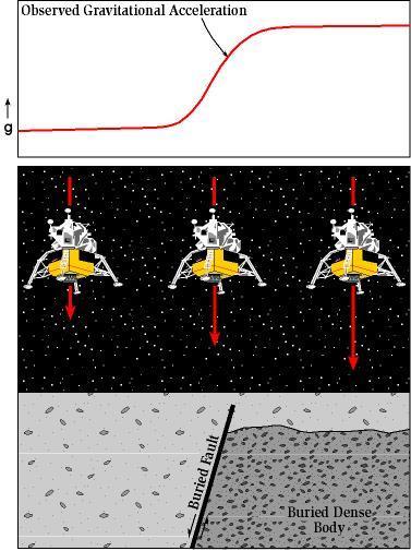
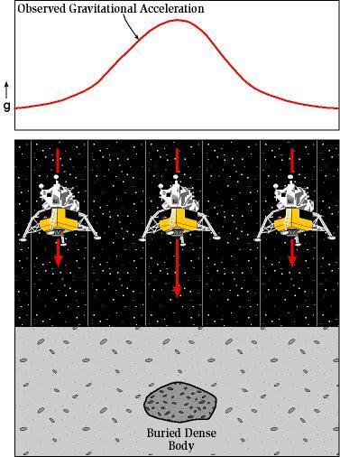
20 Gravity Exploration
21 Magnetic Surveys The magnetic survey measures the variation in the earth s magnetic field mainly caused by the properties of rocks. Basement and igneous rocks are relatively highly magnetic ; also ferrous mineral deposits or buried iron and steel objects can be detected by magnetic survey Magnetic survey is airborne (plane or satellite); permits rapid survey and mapping with good coverage areas Magnetic survey is employed at the beginning of exploration
 and Remote Reservoir Resistivity Mapping CSEM survey is to a large extent complimentary to seismic, as it detects contrasts in electrical")
22 Controlled source electromagnetic (CSEM) surveying CSEM survey is a remote sensing technique that uses very low electromagnetic signals for measuring resistivity of subsurface objects in the marine environment; it is also known as Sea Bed Logging (SBL) and Remote Reservoir Resistivity Mapping CSEM survey is to a large extent complimentary to seismic, as it detects contrasts in electrical conductivity whereas seismic methods detects contrasts in acoustic impedance An electromagnetic field is generated in the substrate using a controlled source (usually towed to about ft above the sea bed) and measured at different offset locations using surface/seabed receivers Receivers are placed on sea floor and locations are based on seismic indication of hydrocarbon
23 What makes it possible to use EM methods for hydrocarbon exploration is that oil and gas have significantly lower electrical conductivity than salt water, so that a porous rock that is saturated with hydrocarbons will have a smaller conductivity (or greater resistance, hence the use of resistivity logs in well logging) than one that is saturated with salt water. The contrast could be as much as a factor of 100. So, when a transmitter (the controlled source) produces an electric current through the sea floor, the response measured at some other position will be affected if hydrocarbons are present.
24 Seismic Exploration When an earthquake or explosion happens, shock waves, also called seismic waves, travel through the ground and reflect off rocks in the subsurface the same way that ripples in a pond reflect off a boat in the water; Because boundaries between different rocks often reflect seismic waves, geophysiscists use these waves to generate pictures of what the subsurface looks like Seismic data can offer us a 2D and 3D image of subsurface before well is drilled; Deepwater wells cost sometimes 100 million; a hand of fore-knowing is crucial; It takes sometimes years before decision to drill is made Seismic data involves four steps: Acquisition Processing Display interpretation

 2.")
25 Seismic Exploration 4 Stages 1. Acquisition To produce a seismic image of the subsurface, a seismic source must be generated and the resulting reflection data recorded by a field crew seismic source of energy: - dynamite - specialized air - vibrator (Vibroseis) 2. Processing Next the data must be processed; the raw data go through many complex procedures using powerful computers and finally a seismic section is produced

26 3. Display Seismic sections are created from the raw data recorded by the field crew, identifying and mapping geological structures that can act as oil traps 4. Interpretation If the results of the interpretation seem favorable, then an exploration borehole will be drilled. A well in a previously unexplored area is called a wildcat
27 Seismic Exploration Environments Land covers almost every type of terrain, such as jungle, desert, forest, urban settings, mountain regions and savannah, that exists on Earth, each with its own logistical problems. Transition Zone (TZ) area where the land meets the sea, such as river deltas, swamps and marshes, coral reefs, beach tidal areas and the surf zone; water is too shallow for large seismic vessels but too deep for the use of land traditional methods of acquisition Marine zone is either in shallow water areas (water depths of less than 30 to 40m for 3D marine seismic operations) or in the deep water areas, such as the Gulf of Mexico
28 Principles of seismic Reflection and Refraction Various layers of subsurface have different acoustical properties. Sound wave travels in different speed in different density rock, like light reflection between air and water boundary. The deeper the layer, the longer the echo takes to reach a hydrophone. where d is the depth of the reflector and V is the wave velocity in the rock
29 Acoustic Impedance Changes in acoustic impedance (AI) give rise to reflected seismic waves j k AI 1 = AI 2 j k AI 1 AI 2 r 1 v 1 =r 2 v 2 r 1 v 1 r 2 v 2 where r is the density and v is the wave velocity in the rock

30 Reflection coefficient AI w = r w v w j AI 1 = r 1 v 1 k AI 2 =r 2 v 2 If r 1 v 1 =r 2 v 2 no reflection Reflection coefficient can be 1 only if V 2 =0; this means the incident wave can not penetrate through the layer 2
31 Assignment In seismic surveys, the fraction of incident energy reflected from interface is called reflection coefficient; it is dependent on acoustic impedance (AI) contrast across interface. Hypothetical Rock Properties: Rock VP, km/s ρ, kg/m3 AI Granite Basalt Limestone Sandstone Shale Determine the reflection coefficient for these rock interfaces: 1) limestone-granite 2) limestone-sandstone 3) limestone-shale, 4) sandstone-shale Which of the interfaces is a poorest reflector? Which of the interfaces is the strongest reflector?
 recorded at the surface via receivers called geophones at")

32 Seismic Data Acquisition Land survey acquisition Sound source: vibrator truck or dynamite Shock wave transmitted Subsurface Reflections (echoes) recorded at the surface via receivers called geophones at different angle Boundaries between various layers of seabed Marine survey acquisition Seismic source: air gun Subsurface Reflections recorded at the surface via receivers called hydrophones at different angle


33 Energy source signal Amount of energy released determines depth of penetration Frequency generated determines vertical resolution; frequency is the inverse of wavelength

34 A group of hydrophones in one stream create one 2D seismic image. 3D seismic image needs to be created by many streams of hydrophones. Different approaches have been applied to overlap many times to avoid interruption from deep water and salt. Narrow azimuth (NAZ) Multi azimuth (MAZ) Wide azimuth (WAZ) Rich azimuth (RAZ) NAZ Seismic wave pass through thick layer of salt often result in distorted data due to well crystallized materials has large refraction effect on wave or light. Multi-azimuth, wide azimuth and rich azimuth seismic has helped improve seismic data in these areas.
35 Definitions Two Way Time A seismic wave is often represented in diagrams as a straight line to show it as a ray; Two way time is the time taken for a surface-generated seismic wave to reach a subsurface rock layer and return to the surface. It is usually measured in milliseconds (1 sec = 1,000 milliseconds)

.")
 indicates the strength of the reflected signal.")
36 Peaks and Troughs Seismic wave is a series of peaks and troughs, a wiggle trace which shows it is composed of peaks and troughs with a zero crossing between the two Seismic interpreters differentiate between a zero crossing from a peak to a trough (positive to negative) and from a trough to a peak (negative to positive). Black wiggly lines Colored coded cross sections Intensity (amplitude) of each line (seismic trace) indicates the strength of the reflected signal. Interval between the strong amplitudes lines measures the time from one received signal to the next.

37 Seismic Velocity There is a wide range of values of velocity as the rocks are very variable. Things that affect the velocity at which the seismic wave can travel through a rock may be: degree of compaction, the presence of fluid, the type of fluid. TWT = two way time Material Typical seismic velocity (m/s) Air 330 Water Sandstone Limestone Clay Common MidPoint (CMP) Number The numbering system used across the top of a seismic profile is the CMP number. Each CMP is a vertical wiggle trace and has its own sequential number and x,y co-ordinate so that it can be located on an ordinance survey map. The distance between each CMP on a given seismic profile is the same, and a tradition has arisen in the seismic industry where 12.5m, 25m and 50m are the most common intervals.
38 Seismic Data Processing Seismic data can be initial processed on recording vessel and further processed and analyzed in computing center. Processing usually passes through three stages: Deconvolution (Filtering) Initial processing firstly eliminate bad records and correct for unwanted shallow surface effects Multiple reflections: multiple reflections (rays bouncing back and forth between layers before reflecting back to the surface) are common in marine seismic data, and are suppressed by seismic processing. Noises are also cleaned up Airwave travels directly from the source to the receiver and is an example of coherent noise; it travels at a speed of 330 m/s, the speed of sound in air Rayleigh wave propagates along a free surface of a solid Refraction/head wave refracts at an interface, travelling along it, within the lower medium and produces oscillatory motion parallel to the interface Cultural noise includes noise from planes, helicopters and electrical pylons and all of these can be detected by the receivers

39 Stacking Over 100 recordings at different locations are combined to form one seismic trace. The goal is to reduce noise ratio and multiple reflections within a single layer. Migration Migration is used to correct the seismic signal reflected from dipped surface. Sound need to be submitted underground such as in a testing well. Velocity of sound in each layer of rock need to be measured in seismic logs. Migration can be performed in time or depth. Migration of seismic section in time domain is time migration which gives the accurate measure of reflection points in constant velocity.


40 Seismic Data Display Simple 2D vertical slices provide first looks at the geology. Horizontal slices (time slices) can also be displayed. 3D cube can be rotated to get different views of the image of the subsurface
41 Seismic Data Interpretation Goal of all previous works is to make correct interpretation and then economic decisions. Knowledge from geophysicists, geologist, petrophysicist and reservoir engineers are needed as they search for the source rock, reservoir and trap for direct indicators of hydrocarbon presence. Direct hydrocarbon indicators (DHI) is an information obtained from seismic analysis that can calibrate other hydrocarbon reservoir information to predict new accumulations. Geophysicists look for DHI Most common DHI is bright spot ; if sandstone is replaced by hydrocarbon, which is low acoustic impedance. Acoustic signal travel through the boundary will have high contrast (large change). This increasing contrast is bright spot Quality of seismic data influences DHI interpretation Amplitude variationwith offset (AVO) is an anomaly also used to predict presence of hydrocarbons; amplitude of seismic signals are affected by: Offset angle Acoustic properties (velocity and density) of reservoir and cap rocks Content of pay zone (oil, gas, water)
42
43 Seismic maps The main purpose of interpretation is to obtain depth map (structural map) of the surveyed area. These maps are given to the geologist to locate potential: 1- Exploration wells 2- Appraisal wells 3- Development wells Type of seismic maps: 1- Isochrones (Time) map 2- Velocities map 3- Depth map Construction of seismic maps: The following tools are required: a base map and seismic section

44 Isochrone map of reflector-1

45 Average velocity map of reflector-1

46 Depth map of reflector-1
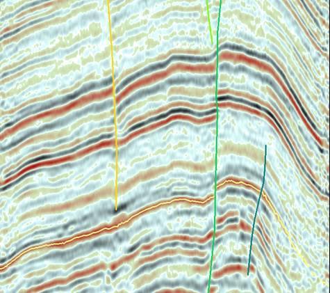
47 1- Base map It consists of the following elements: a- Seismic lines b- Names and number of the seismic lines c- Shot point number d- Location of a wells e- Scale and north symbol A Base map of an area BA-1 Seismic Line BA-3 Shot point BA-2 BA-4 BA-6 BA-8 BA-5 BA-10 BA-12 BA-14 BA-16 N BA-7 BA-9 Well No.1 BA-11 1 cm=100m

48 Two way Time (msec) 2- Seismic sections It is a product of a final stage of data processing Shot point Seismic section of the line BA-3shows subsurface layers
49

50 More Examples

51
Chapter 13: Exploration Techniques
 PTRT 1370 - Petroleum Geology Chapter 13: Exploration Techniques - Mapping - Geophysical Techniques - Seismic Exploration Mapping - Topographic Maps - Absolute Positioning - Geologic Maps - Base Maps -
Subsurface Geology and Resource Exploration
 LAB 11. Subsurface Geology and Resource Exploration Locating earth resources such as aluminum, copper, gold and gemstones has been an important job for geologists for a long time. This lab deals with the
PART A: Short-answer questions (50%; each worth 2%)
") PART A: Short-answer questions (50%; each worth 2%) Your answers should be brief (just a few words) and may be written on these pages if you wish. Remember to hand these pages in with your other exam pages!
PART A: Short-answer questions (50%; each worth 2%) Your answers should be brief (just a few words) and may be written on these pages if you wish. Remember to hand these pages in with your other exam pages!
Geophysical Site Investigation (Seismic methods) Amit Prashant Indian Institute of Technology Gandhinagar
 Amit Prashant Indian Institute of Technology Gandhinagar") Geophysical Site Investigation (Seismic methods) Amit Prashant Indian Institute of Technology Gandhinagar Short Course on Geotechnical Aspects of Earthquake Engineering 04 08 March, 2013 Seismic Waves
Geophysical Site Investigation (Seismic methods) Amit Prashant Indian Institute of Technology Gandhinagar Short Course on Geotechnical Aspects of Earthquake Engineering 04 08 March, 2013 Seismic Waves
Sediment and sedimentary rocks Sediment
 Sediment and sedimentary rocks Sediment From sediments to sedimentary rocks (transportation, deposition, preservation and lithification) Types of sedimentary rocks (clastic, chemical and organic) Sedimentary
UNIT 4 SEDIMENTARY ROCKS
 UNIT 4 SEDIMENTARY ROCKS WHAT ARE SEDIMENTS Sediments are loose Earth materials (unconsolidated materials) such as sand which are transported by the action of water, wind, glacial ice and gravity. These
Hydrocarbon Processing Techniques
 Hydrocarbon Processing Techniques Processes and Techniques Involved in Extracting and Refining Hydrocarbons Key term: Kerogen a mixture of organic matter in sediments from which petroleum is released.
Amplitude variation with offset AVO. and. Direct Hydrocarbon Indicators DHI. Reflection at vertical incidence. Reflection at oblique incidence
 Amplitude variation with offset AVO and Direct Hydrocarbon Indicators DHI Reflection at vertical incidence Reflection coefficient R(p) c α 1 S wavespeed β 1 density ρ 1 α 2 S wavespeed β 2 density ρ 2
Sediment. Weathering: mechanical and chemical decomposition and disintegration of rock and minerals at the surface
 Sediment Some basic terminology Weathering: mechanical and chemical decomposition and disintegration of rock and minerals at the surface Erosion: removal of weathered rock and minerals from one place to
MODULE PREREQUISITES FOR HYDROCARBON ACCUMULATION
 MODULE 1 1.0 PREREQUISITES FOR HYDROCARBON ACCUMULATION The accumulation of hydrocarbons and formation of oil or gas deposit involve certain prerequisites. These are the following: 1. Source Rock 2. Reservoir
What is a sedimentary rock?
 Sedimentary Rocks What is a sedimentary rock? Sedimentary rocks are products of mechanical and chemical weathering They account for only 5% of the top 10 miles of the outer crust, yet most of the earth
NC Earth Science Essential Standards
 NC Earth Science Essential Standards EEn. 2.1 Explain how processes and forces affect the Lithosphere. EEn. 2.1.1 Explain how the rock cycle, plate tectonics, volcanoes, and earthquakes impact the Lithosphere.
Geophysics for Environmental and Geotechnical Applications
 Geophysics for Environmental and Geotechnical Applications Dr. Katherine Grote University of Wisconsin Eau Claire Why Use Geophysics? Improve the quality of site characterization (higher resolution and
Sedimentary rocks. Mechanical Weathering. Weathering. Chemical weathering. Rates of weathering. Fossil Fuel Resources. Two kinds of weathering
 Sedimentary rocks Fossil Fuel Resources Exam next Tuesday February 14 Bring Scantron and Review Questions About 75% of all rock outcrops on the continents Important to reconstruct much of Earth's history
Today s oil is yesterday s plankton
 Oil and Gas Basics 2 Today s oil is yesterday s plankton Small marine and lake organisms live in surface waters They die, fall to the bottom and get buried into an organic rich sedimentary layer If geologic
Lecture Outline Wednesday - Friday February 14-16, 2018
 Lecture Outline Wednesday - Friday February 14-16, 2018 Quiz 2 scheduled for Friday Feb 23 (Interlude B, Chapters 6,7) Questions? Chapter 6 Pages of the Past: Sedimentary Rocks Key Points for today Be
P066 Duplex Wave Migration for Coal-bed Methane Prediction
 P066 Duplex Wave Migration for Coal-bed Methane Prediction N. Marmalevskyi* (Ukrainian State Geological Prospecting Institute), A. Antsiferov (UkrNIMI), Z. Gornyak (Ukrainian State Geological Prospecting
Reservoirs and Production
 Lesson Plan - Page 1 Topic Reservoirs and Production Source Oil and Natural Gas, pages 24-25, 26-27 Objective The students will learn that porosity refers to the percentage of holes (pores) in the rock.
Exploration, Drilling & Production
 Nontechnical Guide to PETMOLEUM Geology, Exploration, Drilling & Production Third Edition Norman J. Hyne, Ph.D. Contents Preface *i Introduction 1 The Nature of Gas and Oil 1 Petroleum 1 The Chemistry
Lab 7: Sedimentary Structures
 Name: Lab 7: Sedimentary Structures Sedimentary rocks account for a negligibly small fraction of Earth s mass, yet they are commonly encountered because the processes that form them are ubiquitous in the
ESC102. Sedimentary Rocks. Our keys to the past. Monday, February 11, 13
 ESC102 Sedimentary Rocks Our keys to the past Sedimentary Rocks Sedimentary rocks are rocks that form through the accumulation of sediment and the process of lithification. Lithification occurs after deposition
Tim Carr - West Virginia University
 Tim Carr - West Virginia University Understanding Seismic Data Resolution (Vertical and Horizontal) Common Depth Points (CDPs) Two way time (TWT) Time versus depth Interpretation of Reflectors 2 Able to
1. Canadian Energy Use
 1 Unit 3 Energy 2 1. Canadian Energy Use Why are Canadians the sixth highest energy users in the world? Our major industries are energy intensive, overall industry consumes 31% of all energy in Canada.
Chapter 7: Reflection Seismology Homework Solutions (Jan. 2010)
") Chapter 7: eflection Seismology Homework Solutions (Jan. 200). Why do marine seismic reflection surveys not record (a) S waves? (b) refracted rays? 2 μ a) For ideal fluid, μ=0, thus, v s = = 0 ρ b) eflection
Chapter 7: eflection Seismology Homework Solutions (Jan. 200). Why do marine seismic reflection surveys not record (a) S waves? (b) refracted rays? 2 μ a) For ideal fluid, μ=0, thus, v s = = 0 ρ b) eflection
FUNDAMENTALS OF SEISMIC EXPLORATION FOR HYDROCARBON
 FUNDAMENTALS OF SEISMIC EXPLORATION FOR HYDROCARBON Instructor : Kumar Ramachandran 10 14 July 2017 Jakarta The course is aimed at teaching the physical concepts involved in the application of seismic
Bowen s Chemical Stability Series
 Lab 5 - Identification of Sedimentary Rocks Page - Introduction Sedimentary rocks are the second great rock group. Although they make up only a small percentage of the rocks in the earth s crust (~5%)
Geologic Resources. Geologic Resources and Society. Geologic Resources and Society
 Geologic Resources Our entire society rests upon - and is dependent upon - our water, our land, our forests, and our minerals. How we use these resources influences our health, security, economy, and well-being.
13. Sedimentary Rocks I (p )
") 13. Sedimentary Rocks I (p. 194-208) Sediment Deposition Weathering results in rock being broken down into smaller fragments, called regolith. This regolith is then broken down to form soil. The regolith
13. Sedimentary Rocks I (p. 194-208) Sediment Deposition Weathering results in rock being broken down into smaller fragments, called regolith. This regolith is then broken down to form soil. The regolith
Sediment and Sedimentary rock
 Sediment and Sedimentary rock Sediment: An accumulation of loose mineral grains, such as boulders, pebbles, sand, silt or mud, which are not cemented together. Mechanical and chemical weathering produces
Oil & Gas. From exploration to distribution. Week 1 V05 Origin of hydrocarbon resources part 1. Jean-Pierre Deflandre
 Oil & Gas From exploration to distribution Week 1 V05 Origin of hydrocarbon resources part 1 Jean-Pierre Deflandre W1V5 Origin of hydrocarbon resources1 p. 1 Introduction to hydrocarbon resources You will
Geography 3202 Unit 4 S.C.O. 4.3 & 4.5. Primary Resource Activities Offshore Oil And Gas
 Geography 3202 Unit 4 S.C.O. 4.3 & 4.5 Primary Resource Activities Offshore Oil And Gas Factors Affecting The Decision To Recover Offshore Oil And Gas (4.3.1) Physical Factors 1. Ocean Related Factors
Tim Carr - West Virginia University
 Tim Carr - West Virginia University Exploration s Ultimate Goal is to Answer Four Questions: Where to Drill? What to Expect? How Certain? How Profitable? Location & Depth HC Volumes Chance of Success
Sedimentary Environments Chapter 8
 Sedimentary Environments Chapter 8 Does not contain complete lecture notes. To be used to help organize lecture notes and home/test studies. What is a sedimentary rock? Sedimentary rocks are products of
Chapter 3: Geology and Geophysics
 PTRT 1471- Exploration and Production 1 Chapter 3: Geology and Geophysics - Formation of Rocks - Deformation of Rocks - Formation of Petroleum -Traps - Continental Margins - Offshore Boundaries - Offshore
National Geophysical Survey Science Opportunities
 National Geophysical Survey Science Opportunities Anton Ziolkowski Professor of Petroleum Geoscience University of Edinburgh BGS Keyworth 4 April 2016 Outline Brief biography Science opportunities High
Why is quartz one of the most weathering-resistant minerals?
 Why is it a poor idea to use limestone for tombstones in a wet hot area like the Amazon rainforest? A) Because limestone weathers at a very fast rate B) Because limestone weathers at a very low rate C)
Outline 16: The Mesozoic World: Formation of Oil Deposits (with a side trip to the Devonian Marcellus Shale)
") Outline 16: The Mesozoic World: Formation of Oil Deposits (with a side trip to the Devonian Marcellus Shale) The first commercial oil well was drilled by Colonel Edwin Drake in Titusville, Pennsylvania,
Outline 16: The Mesozoic World: Formation of Oil Deposits (with a side trip to the Devonian Marcellus Shale) The first commercial oil well was drilled by Colonel Edwin Drake in Titusville, Pennsylvania,
Name Class Date. In your textbook, read about the nature of igneous rocks. Use each of the terms below just once to complete the following statements.
 CHAPTER 5 Igneous Rocks SECTION 5.1 What are igneous rocks? In your textbook, read about the nature of igneous rocks. Use each of the terms below just once to complete the following statements. basaltic
Sedimentary Rocks - are one of the three main rock types
 Today s Objective: What Makes Sedimentary Rocks Special? Sedimentary Rocks - are one of the three main rock types A sedimentary rock can form one of three ways: 1. by the deposition of the weathered remains
Tu P05 06 Duplex Wave Migration Case Study in Yemen
 Tu P05 06 Duplex Wave Migration Case Study in Yemen G. Markarova* (Calvalley Petroleum Inc), I. Blumentsvaig (TetraSeis Inc.), A. Kostyukevych (TetraSeis Inc.) & N. Marmalyevskyy (TetraSeis Inc.) SUMMARY
2011 SEG SEG San Antonio 2011 Annual Meeting 771. Summary. Method
 Geological Parameters Effecting Controlled-Source Electromagnetic Feasibility: A North Sea Sand Reservoir Example Michelle Ellis and Robert Keirstead, RSI Summary Seismic and electromagnetic data measure
Delineating a sandstone reservoir at Pikes Peak, Saskatchewan using 3C seismic data and well logs
 Delineating a sandston reservoir at Pikes Peak Delineating a sandstone reservoir at Pikes Peak, Saskatchewan using 3C seismic data and well logs Natalia L. Soubotcheva and Robert R. Stewart ABSTRACT To
2 Igneous Rock. How do igneous rocks form? What factors affect the texture of igneous rock? BEFORE YOU READ. Rocks: Mineral Mixtures
 CHAPTER 4 2 Igneous Rock SECTION Rocks: Mineral Mixtures BEFORE YOU READ After you read this section, you should be able to answer these questions: How do igneous rocks form? What factors affect the texture
Contents. Introduction. Introduction. Modern Environments. Tools for Stratigraphic Analysis
 Contents Tools for Stratigraphic Analysis Introduction of Study: Modern Environments of Study: Ancient Deposits Summary Introduction Basin analysts use a variety of methods to study modern and ancient
3. Magnetic Methods / 62
 Contents Preface to the Second Edition / xv Excerpts from Preface to the FirstEdition / xvii Mathematical Conventions / xix 1. Introduction / 1 Reference / 5 2. Gravity Methods / 6 2. I. Introduction /
Tim Carr - West Virginia University
 GEOGRAPHIC EXTENT OF PETROLEUM SYSTEM A Trap Trap Trap A STRATIGRAPHIC EXTENT OF PETROLEUM SYSTEM Petroleum accumulation Top of oil window Bottom of oil window Overburden Seal Reservoir Source Underburden
Chapter 10. Chapter Rocks and the Rock Cycle. Rocks. Section 1 Rocks and the Rock Cycle
 Chapter 10 Rocks 1 Chapter 10 Section 1 Rocks and the Rock Cycle 2 10.1 Rocks and the Rock Cycle Magma is the parent material for all rocks. Once the magma cools and hardens, many changes can occur. Geology:
As compaction and cementation of these sediments eventually occur, which area will become siltstone? A) A B) B C) C D) D
 A B) B C) C D) D") 1. A student obtains a cup of quartz sand from a beach. A saltwater solution is poured into the sand and allowed to evaporate. The mineral residue from the saltwater solution cements the sand grains together,
1. A student obtains a cup of quartz sand from a beach. A saltwater solution is poured into the sand and allowed to evaporate. The mineral residue from the saltwater solution cements the sand grains together,
Rocks & Minerals. Lesson 1 Properties of Minerals. What is a mineral? What is a mineral?
 Rocks & Minerals What is a mineral? A mineral must have 5 specific characteristics to be considered a mineral a. b. c. d. e. Naturally occurring - formed by natural processes. Solid - must have a definite
ERTH2020 Introduction to Geophysics The Seismic Method. 1. Basic Concepts in Seismology. 1.1 Seismic Wave Types
 ERTH2020 Introduction to Geophysics The Seismic Method 1. Basic Concepts in Seismology 1.1 Seismic Wave Types Existence of different wave types The existence of different seismic wave types can be understood
PETROLEUM GEOSCIENCES GEOLOGY OR GEOPHYSICS MAJOR
 PETROLEUM GEOSCIENCES GEOLOGY OR GEOPHYSICS MAJOR APPLIED GRADUATE STUDIES Geology Geophysics GEO1 Introduction to the petroleum geosciences GEO2 Seismic methods GEO3 Multi-scale geological analysis GEO4
Seismic Attributes and Their Applications in Seismic Geomorphology
 Academic article Seismic Attributes and Their Applications in Seismic Geomorphology Sanhasuk Koson, Piyaphong Chenrai* and Montri Choowong Department of Geology, Faculty of Science, Chulalongkorn University,
GEOLOGY MEDIA SUITE Chapter 5
 UNDERSTANDING EARTH, SIXTH EDITION GROTZINGER JORDAN GEOLOGY MEDIA SUITE Chapter 5 Sedimentation Rocks Formed by Surface Processes 2010 W.H. Freeman and Company Mineralogy of sandstones Key Figure 5.12
Improved Exploration, Appraisal and Production Monitoring with Multi-Transient EM Solutions
 Improved Exploration, Appraisal and Production Monitoring with Multi-Transient EM Solutions Folke Engelmark* PGS Multi-Transient EM, Asia-Pacific, Singapore folke.engelmark@pgs.com Summary Successful as
INTEGRATED GEOPHYSICAL INTERPRETATION METHODS FOR HYDROCARBON EXPLORATION
 INTEGRATED GEOPHYSICAL INTERPRETATION METHODS FOR HYDROCARBON EXPLORATION Instructor : Kumar Ramachandran 31 July 4 August 2017 Jakarta COURSE OUTLINE The course is aimed at imparting working knowledge
A Study of Uphole to Determine the Shooting Medium for Seismic Reflection Survey at Himalayan Foot Hill Area
 A Study of Uphole to Determine the Shooting Medium for Seismic Reflection Survey at Himalayan Foot Hill Area Summary Binode Chetia Frontier Basins, ONGC, Dehradun E-mail: chetia_binode@ongc.co.in Acquiring
Improved Interpretability via Dual-sensor Towed Streamer 3D Seismic - A Case Study from East China Sea
 Improved Interpretability via Dual-sensor Towed Streamer 3D Seismic - A Case Study from East China Sea S. Rongfu (CNOOC Shanghai), C. Hua (CNOOC Shanghai), W. Yun (CNOOC Shanghai), Z. Yabin (CNOOC Shanghai),
MUHAMMAD S TAMANNAI, DOUGLAS WINSTONE, IAN DEIGHTON & PETER CONN, TGS Nopec Geological Products and Services, London, United Kingdom
 Geological and Geophysical Evaluation of Offshore Morondava Frontier Basin based on Satellite Gravity, Well and regional 2D Seismic Data Interpretation MUHAMMAD S TAMANNAI, DOUGLAS WINSTONE, IAN DEIGHTON
Earth in 2-D, 3-D & 4-D
 Earth in 2-D, 3-D & 4-D We will consider the scientific tools and techniques used to map surface features, reconstruct the layered structure of Earth, and interpret Earth history, including the origin
Multifocusing 3D diffraction imaging for dectection of fractured zones in mudstone reservoirs
 Multifocusing 3D diffraction imaging for dectection of fractured zones in mudstone reservoirs Alana Schoepp, Evgeny Landa, Stephane Labonte Shell Canada Ltd., Geomage, Shell CanadaLtd Summary Unconventional
Section I: Multiple Choice Select the best answer to each question. Mark your final answer on the answer sheet. (1 pt each)
") Sedimentary Rocks & Surface Processes Quest Name: Earth Science 2013 Block: Date: Section I: Multiple Choice Select the best answer to each question. Mark your final answer on the answer sheet. (1 pt each)
Sedimentary Rocks & Surface Processes Quest Name: Earth Science 2013 Block: Date: Section I: Multiple Choice Select the best answer to each question. Mark your final answer on the answer sheet. (1 pt each)
Formation Evaluation: Logs and cores
 These powerpoint files were produced for the Earth History class at the Free University Berlin, Department of Geological Sciences The copyright for texts, graphical elements, and images lies with C. Heubeck,
Rocks Rock- A group of minerals, glass, mineroid bound together in some way.
 Rocks Rock- A group of minerals, glass, mineroid bound together in some way. All rocks fit into one of three categories: Igneous- formed by the cooling and hardening of hot molten rock Sedimentary- formed
1. are most likely to study the images sent back from Mars. A. Astronomers B. Geologists C. Doctors D. Engineers
 1. are most likely to study the images sent back from Mars. A. Astronomers B. Geologists C. Doctors D. Engineers 2. When did the Earth form? A. About 540 million years ago B. About 2.5 billion years ago
Reservoirs and Production
 Lesson Plan Page 1 Topic: Reservoirs and production Topic Overview: Porosity refers to the percentage of holes (pores) in the rock. Permeability is the ability of fluids to travel through porous rocks.
Assessing our untapped energy resources. Derek Reay Geological Survey of Northern Ireland
 Assessing our untapped energy resources Derek Reay Geological Survey of Northern Ireland Talk Outline Northern Ireland energy market Oil and Gas Exploration Description Exploration risks Application of
A Petroleum Geologist's Guide to Seismic Reflection
 A Petroleum Geologist's Guide to Seismic Reflection William Ashcroft WILEY-BLACKWELL A John Wiley & Sons, Ltd., Publication Contents Preface Acknowledgements xi xiii Part I Basic topics and 2D interpretation
Geology and Natural Resources
 Geology and Natural Resources Brought to you by: Western Michigan University Department of Geosciences and The Michigan Geological Repository for Research and Education s K-12 Outreach Program Core Kids
Static Corrections for Seismic Reflection Surveys
 Static Corrections for Seismic Reflection Surveys MIKE COX Volume Editors: Series Editor: Eugene F. Scherrer Roland Chen Eugene F. Scherrer Society of Exploration Geophysicists Tulsa, Oklahoma Contents
Feasibility and design study of a multicomponent seismic survey: Upper Assam Basin
 P-276 Summary Feasibility and design study of a multicomponent seismic survey: Upper Assam Basin K.L.Mandal*, R.K.Srivastava, S.Saha, Oil India Limited M.K.Sukla, Indian Institute of Technology, Kharagpur
FIREPLACE GEOLOGY. Dining Hall
 FIREPLACE GEOLOGY Dining Hall The Dining Hall fireplace represents a slice through a Cascade Mountain volcano. Volcanoes are formed from molten magma rising up from within the Earth s crust. Magma that
Ground-Water Exploration in the Worthington Area of Nobles County: Summary of Seismic Data and Recent Test Drilling Results
 Ground-Water Exploration in the Worthington Area of Nobles County: Summary of Seismic Data and Recent Test Drilling Results Jim Berg and Todd Petersen Geophysicists, DNR Waters January 2000 Table of Contents
Sedimentary Rocks. Rocks made of bits & pieces of other rocks.
 Sedimentary Rocks Rocks made of bits & pieces of other rocks. Sedimentary Rocks Igneous rocks are the most common rocks on Earth, but because most of them exist below the surface you might not have seen
Lab 9: Petroleum and groundwater
 Geology 101 Name(s): Lab 9: Petroleum and groundwater Petroleum (oil) is a multi-component liquid refined to generate different hydrocarbons, such as heptane (a component of gasoline) and waxes. For the
Downloaded 11/20/12 to Redistribution subject to SEG license or copyright; see Terms of Use at
 AVO crossplot analysis in unconsolidated sediments containing gas hydrate and free gas: Green Canyon 955, Gulf of Mexico Zijian Zhang* 1, Daniel R. McConnell 1, De-hua Han 2 1 Fugro GeoConsulting, Inc.,
An Introduction to Geophysical Exploration
 An Introduction to Geophysical Exploration Philip Kearey Department of Earth Sciences University of Bristol Michael Brooks Ty Newydd, City Near Cowbridge Vale of Glamorgan Ian Hill Department of Geology
Sedimentary Rocks Chapter 6
 Sedimentary Rocks Chapter 6 I. What is a sedimentary rock? A. Sedimentary rock 1) Rock made of detrital sediments (such as sand) or inorganic/organic chemical precipitates (such as calcite) 2) Detrital
Petroleum Systems (Part One) Source, Generation, and Migration
 Source, Generation, and Migration") Petroleum Systems (Part One) Source, Generation, and Migration GEOL 4233 Class January 2008 Petroleum Systems Elements Source Rock Migration Route Reservoir Rock Seal Rock Trap Processes Generation Migration
Petroleum Systems (Part One) Source, Generation, and Migration GEOL 4233 Class January 2008 Petroleum Systems Elements Source Rock Migration Route Reservoir Rock Seal Rock Trap Processes Generation Migration
Vertical Hydrocarbon Migration at the Nigerian Continental Slope: Applications of Seismic Mapping Techniques.
 ROAR HEGGLAND, Statoil ASA, N-4035 Stavanger, Norway Vertical Hydrocarbon Migration at the Nigerian Continental Slope: Applications of Seismic Mapping Techniques. Summary By the use of 3D seismic data,
Introduction to Formation Evaluation Abiodun Matthew Amao
 Introduction to Formation Evaluation By Abiodun Matthew Amao Monday, September 09, 2013 Well Logging PGE 492 1 Lecture Outline What is formation evaluation? Why do we evaluate formation? What do we evaluate?
Paleo Lab #4 - Sedimentary Environments
 Paleo Lab #4 - Sedimentary Environments page - 1. CHARACTERISTICS OF SEDIMENT Grain size and grain shape: The sizes and shapes of sedimentary particles (grains) are modified considerably during their transportation
EPS 50 Lab 4: Sedimentary Rocks
 Name: EPS 50 Lab 4: Sedimentary Rocks Grotzinger and Jordan, Chapter 5 Introduction In this lab we will classify sedimentary rocks and investigate the relationship between environmental conditions and
NOTE OUTLINE : Chap 5 & 6: Rocks
 Name Period NOTE OUTLINE : Chap 5 & 6: Rocks Objectives 1. Identify and explain characteristics of igneous rocks. This means that if I am given an igneous rock I: a. Can use grain size to identify a rock
GLG Chapter 7 Sedimentary Environments & Rocks
 GLG 101 - Chapter 7 Sedimentary Environments & Rocks Name Note, Oct 11: I ll be writing this study sheet over the next few days. Each day I will add questions until the entire chapter is done, hopefully
Sedimentary Rocks. All sedimentary rocks begin to form when existing rocks are broken down into sediments Sediments are mainly weathered debris
 Rocks! Objectives Describe the major processes involved in the formation of sedimentary rock Distinguish between clastic sedimentary rocks and chemical sedimentary rocks Identify the features that are
Risk Analysis Methods
 Economic Risk and Decision Analysis for Oil and Gas Industry CE81.9008 School of Engineering and Technology Asian Institute of Technology January Semester Presented by Dr. Thitisak Boonpramote Department
6/20/2018. Lesson 1 (Properties of Minerals) 6 th Grade. Earth s Structure Chapter 2: Minerals and Rocks. density =
 6 th Grade. Earth s Structure Chapter 2: Minerals and Rocks. density =") 6 th Grade Earth s Structure Chapter 2: Minerals and Rocks Mineral Lesson 1 (Properties of Minerals) a mineral must meet all four of the following requirements: 1. must be naturally-occurring (formed by
6 th Grade Earth s Structure Chapter 2: Minerals and Rocks Mineral Lesson 1 (Properties of Minerals) a mineral must meet all four of the following requirements: 1. must be naturally-occurring (formed by
Sedimentary Rocks, our most Valuable Rocks. Or, what you will probably find when you are outdoors exploring.
 Sedimentary Rocks, our most Valuable Rocks Or, what you will probably find when you are outdoors exploring. Sedimentary rocks give us evidence to earth s earlier history. We look at processes happening
The Pennsylvania State University. The Graduate School. Department of Electrical Engineering LOCATING PETROLEUM SOURCES USING DSP TECHNIQUES
 The Pennsylvania State University The Graduate School Department of Electrical Engineering LOCATING PETROLEUM SOURCES USING DSP TECHNIQUES A Thesis in Electrical Engineering by Wenxin Song 2015 Wenxin
RKC Newsltter-Direct Hydrocarbon Indicators.
 RKC Newsltter-Direct Hydrocarbon Indicators. This article will discuss a few oddball seismic facies associated with fluid expulsion-be it water or hydrocarbons, and some of the less obvious effects that
Sediments and Sedimentary Rocks
 Sediments and Sedimentary Rocks (Shaping Earth s Surface, Part 2) Science 330 Summer 2005 What is a sedimentary rock? Products of mechanical and chemical weathering Account for about 5 percent of Earth
Walkaway Seismic Experiments: Stewart Gulch, Boise, Idaho
 Walkaway Seismic Experiments: Stewart Gulch, Boise, Idaho Lee M. Liberty Center for Geophysical Investigation of the Shallow Subsurface Boise State University Boise, Idaho 1. Summary CGISS conducted walkaway
Integrating rock physics and full elastic modeling for reservoir characterization Mosab Nasser and John B. Sinton*, Maersk Oil Houston Inc.
 Integrating rock physics and full elastic modeling for reservoir characterization Mosab Nasser and John B. Sinton*, Maersk Oil Houston Inc. Summary Rock physics establishes the link between reservoir properties,
SEG Houston 2009 International Exposition and Annual Meeting
 The role of EM rock physics and seismic data in integrated 3D CSEM data analysis I. Brevik*, StatoilHydro, Pål T. Gabrielsen, Vestfonna and Jan Petter Morten, EMGS Summary An extensive 3D CSEM dataset
Seismic Reflection Imaging across the Johnson Ranch, Valley County, Idaho
 Seismic Reflection Imaging across the Johnson Ranch, Valley County, Idaho Report Prepared for the Skyline Corporation Lee M. Liberty Center for Geophysical Investigation of the Shallow Subsurface (CGISS)
State the principle of uniformitarianism. Explain how the law of superposition can be used to determine the relative age of rocks.
 Objectives State the principle of uniformitarianism. Explain how the law of superposition can be used to determine the relative age of rocks. Compare three types of unconformities. Apply the law of crosscutting
Hydrocarbon Trap Classification Based on Associated Gas Chimneys
 Chapter 14 Hydrocarbon Trap Classification Based on Associated Gas Chimneys Roar Heggland 1 Abstract Oil seeps, shallow gas, and surface features such as seabed pockmarks and mud volcanoes are historically
Pre Stack Imaging To Delineate A New Hydrocarbon Play A Case History
 5th Conference & Exposition on Petroleum Geophysics, Hyderabad-2004, India PP 375-379 Pre Stack Imaging To Delineate A New Hydrocarbon Play A Case History D. Srinivas, T.R. Murali Mohan, Ashwani Lamba,
Objectives: Define Relative Age, Absolute Age
 S6E5. Students will investigate the scientific view of how the earth s surface is formed. c. Classify rocks by their process of formation. g. Describe how fossils show evidence of the changing surface
Practice Test Rocks and Minerals. Name. Page 1
 Name Practice Test Rocks and Minerals 1. Which rock would be the best source of the mineral garnet? A) basalt B) limestone C) schist D) slate 2. Which mineral is mined for its iron content? A) hematite