MIDDLE DEVONIAN PLAY MICHIGAN BASIN OF ONTARIO. Duncan Hamilton
|
|
|
- Georgiana Barnett
- 5 years ago
- Views:
Transcription


1 MIDDLE DEVONIAN PLAY MICHIGAN BASIN OF ONTARIO Duncan Hamilton 1

2 Middle Devonian Pools of the Michigan Basin 375+ Million Barrels Michigan 45+ million Barrels Ontario 2
3 Outline of Presentation History of the Play Significant Devonian Pools General Play Parameters Field Example Rodney Pool Use of Modern Technology Future Potential 3

4 History of the Play First commercial oil discovery at Oil Springs % of oil discovered prior to 1900 Last major discovery in 1949 Initial flow rates as high as 7,500 bbls/d Produced 45+ million barrels to date Some of the original pools still producing Pools found mainly from oil seeps, tar beds Limited and sporadic drilling in recent times 4
5 Significant Devonian Pools of Ontario POOL NAME DISCOVERY YEAR CUMMULATIVE PRODUCTION (barrels) ACTIVE Oil Springs ,437,000 Yes Petrolia ,798,000 Yes Bothwell-Thamesville ,354,000 Yes Wallacetown ,000 No Glencoe ,139,000 No Watford-Kerwood ,000 No Rodney ,845,000 Yes 5
6 General Play Parameters Stratigraphy Devonian Play Fairway Location of Pools Dundee Structure Structural Trap Formation Concept Summary of Play Parameters 6
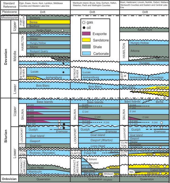
7 Stratigraphic Column 7

8 Middle Devonian Play Stratigraphy 8

9 Middle Devonian Pool Fairway Devonian Pool Fairway (Lazorek, M., and Carter, T.R., 2008) 9
10 Devonian Pool Location Map 10

11 Dundee Structure Map 11

12 Salt-Dissolution Generated Structural Traps Conceptual model of Devonian structural traps formed by differential salt dissolution in the Salina Group (Lazorek, M., and Carter, T.R., 2008). 12
13 Summary of Play Parameters Key Reservoirs: Dundee Formation : Lucas Formation: Other Production/Shows: Siliclastic-rich dolomite (Rodney) (from 100% sand to 100% dolomite) Sucrosic Dolomite (Oil Springs, Petrolia) Sandstone (Glencoe) Dundee fractured limestones Hamilton fractured shale Porosity: 8 to 30% Permeability: 5 to 2,500 md Trapping Seal: Hamilton shale, tight Dundee limestone 13
14 Summary of Play Parameters Trapping Mechanism: Depth of Reservoirs: Thickness of Overburden: Exploration Methods: Drilling and Casing: Completion: Salt-Solution generated structural highs 350 to 450 feet 50 to 300 feet Oil Seeps, tar beds, structural testing Mainly cable tool and minor rotary Open-hole and cased-through and perforated Acidization and some frac ing 14
15 Rodney Field Example General Field Data Date of Discovery: 1949 Exploration Methods: Structural Testing Type of Trap: Structural (Salt-generated) Reservoir Lithology: Siliclastic-rich dolomite Producing Area: 1600 acres Number of Producing Wells: 200 Producers, 100 Injectors Drilling and Casing: Open-hole and cased-through and perforated Completion: Acidization and some frac ing 15
16 Rodney Field Example Reservoir Data Producing Formation: Dundee Columbus Zone Depth to Reservoir: 360 to 430 feet Deepest Zone Tested: Cambrian Pay Thickness: 15 to 24 feet ( 4 to 6 meters) Pay Lithology Siliciclastic-rich Dolomite Pore Types: Intercrystalline, vuggy, fracture and intergranular Porosity: 10 to 30% Permeability: 5 to 2,500 md Oil Character: 38 API (sour) Water Saturation: Variable 10 to 30% 16
17 Rodney Field Example Other Reservoir Data Original Reservoir Pressure: Drive Mechanism: Original OOIP: Production to Date: Initial Production/Well: Peak Daily Production: Current Daily Production: Secondary Recovery: 175 psig (1,206 kpa) Solution Gas 18 million barrels million barrels 2 to 118 BOPD 1,200 BOPD 60 BOPD Water-flood on 5-spot, line and peripheral pattern Cores: 10 Wireline Logs: Basic Gr/N to Nil. 17


18 Dundee Structure Map Rodney Pools A A 18

19 Rodney Pool 2D Seismic Template Line A A Hamilton Shale Pool Edge Devonian Structure Silurian Salt Pool Edge Hamilton Shale 19
 pay section")
20 Rodney Field Type Log 12 to 24% porosity Quartz-sand-rich intervals Dolomitized crinoidal grainstone to packsone 20 foot (6 m) pay section 20
21 Exploration Tools Use of Modern Technology Computer mapping of key geological tops and isopachs High-resolution gravity and magnetics Potential mapping of structures with 2D (3D) seismic Waterflooding Successful water-flood results in the Rodney field 5-spot flood pattern very effective To date recovered approximately 60% of OOIP 21
22 Use of Modern Technology Horizontal Drilling To date marginal success based on 3 wells Challenge to make the turn within 100 to 150 feet bedrock Relatively thin pay zone and heterogeneous reservoir Vertical permeability variable Due to shallow depth, lack of significant reservoir drive Limited stimulation options due to proximity of overlying fresh water aquifer and underlying Lucas water zones 22
23 Future Potential Remaining potential for smaller pools in 1 to 5 million barrels Areas within the Devonian fairway with relatively sparse drilling Potential to image structures with high-resolution gravity due to density contrasts of preserved sections of Salina salts. Use of magnetics data (OGS dataset) to map potential faults Use of old-fashioned conventional geological mapping Use of 2D seismic to confirm structure and drill locations Attractive economics with relatively low cost to drill a vertical test well $75,000 to $80,000 23

24 Future Potential Exploration Areas 24
DEVONIAN OIL AND GAS PLAYS OF THE MICHIGAN BASIN
 DEVONIAN OIL AND GAS PLAYS OF THE MICHIGAN BASIN William B. Harrison, III Michigan Geological Repository for Research and Education (MGRRE) Western Michigan University-Michigan Geological Survey 1 Devonian
Exploration, Drilling & Production
 Nontechnical Guide to PETMOLEUM Geology, Exploration, Drilling & Production Third Edition Norman J. Hyne, Ph.D. Contents Preface *i Introduction 1 The Nature of Gas and Oil 1 Petroleum 1 The Chemistry
SILURIAN REEF PLAY IN ONTARIO. Allan Phillips (Clinton-Medina Group)
") SILURIAN REEF PLAY IN ONTARIO Allan Phillips (Clinton-Medina Group) 1 MIDDLE AND UPPER SILURIAN CARBONATES AND EVAPORATES Middle and Upper Silurian age carbonate and evaporite sequence in Lambton, Kent,
SILURIAN REEF PLAY IN ONTARIO Allan Phillips (Clinton-Medina Group) 1 MIDDLE AND UPPER SILURIAN CARBONATES AND EVAPORATES Middle and Upper Silurian age carbonate and evaporite sequence in Lambton, Kent,
The Oyster Bayou CO 2 Flood Case History. Alton Ahrens, Denbury Resources
 The Oyster Bayou CO 2 Flood Case History Alton Ahrens, Denbury Resources N Y S E : D N R w w w. d e n b u r y. c o m Table of Contents o Highlights of the CO2 Flood o Pre-CO 2 History o o o Location and
COPYRIGHT. Optimization During the Reservoir Life Cycle. Case Study: San Andres Reservoirs Permian Basin, USA
 Optimization During the Reservoir Life Cycle Case Study: San Andres Reservoirs Permian Basin, USA San Andres Reservoirs in the Permian Basin Two examples of life cycle reservoir management from fields
OIL AND GAS PLAYS OF THE MICHIGAN BASIN, SOUTHERN ONTARIO. Terry Carter, Consulting Geologist London, Ontario
 OIL AND GAS PLAYS OF THE MICHIGAN BASIN, SOUTHERN ONTARIO Terry Carter, Consulting Geologist London, Ontario 1 Ontario Petroleum Industries Oil and Natural Gas 1250 oil wells, 1200 gas wells, annual production
Masila 1: Shallow shelf carbonate facies variability and secondary reservoir development - Saar Formation Masila block, Yemen
 Masila 1: Shallow shelf carbonate facies variability and secondary reservoir development - Saar Formation Masila block, Yemen Kent Wilkinson* Nexen Inc., Calgary, AB kent_wilkinson@nexeninc.com ABSTRACT
MAPPING AND RESERVOIR CHARACTERIZATION OF GEOLOGIC INTERVALS FOR NGL STORAGE APPLICATIONS
 MAPPING AND RESERVOIR CHARACTERIZATION OF GEOLOGIC INTERVALS FOR NGL STORAGE APPLICATIONS Robin V. Anthony 1, Doug Patchen 2, Jessica Moore 3, Michael Solis 4 1 PA DCNR, Bureau of Topographic & Geologic
Horizontal Injectors & Producers at SACROC Clyde Findlay II & Jeremy Pitts
 1 Horizontal Injectors & Producers at SACROC Clyde Findlay II & Jeremy Pitts Presented at the CO 2 & ROZ Conference. Dec 6, 2018 SACROC 2 SACROC phih Map 1948 - discovered in Scurry County, Texas 52,000
Subsurface Geology and Resource Exploration
 LAB 11. Subsurface Geology and Resource Exploration Locating earth resources such as aluminum, copper, gold and gemstones has been an important job for geologists for a long time. This lab deals with the
Devonian Petroleum Systems and Exploration Potential, Southern Alberta, Part 3 Core Conference
 Devonian Petroleum Systems and Exploration Potential, Southern Alberta, Part 3 Core Conference Andy Mort (1), Leonard Stevens (2), Richard Wierzbicki (2) Abstract Part 1: Devonian Petroleum Systems Dr.
For personal use only
 Quarterly Activities Report Quarter Ending 30 September 2018 (ASX Code: HE8) (Helios or Company) is pleased to report its activities for the quarter ended 30 September 2018. Oil Discovery in the Ojinaga
The North Dakota Bakken Play - Observations. Julie A. LeFever North Dakota Geological Survey
 The North Dakota Bakken Play - Observations Julie A. LeFever North Dakota Geological Survey The Basics Bakken Formation in North Dakota Upper & Lower Black Shale World Class Source Rock TOC s as high as
Risk Factors in Reservoir Simulation
 Risk Factors in Reservoir Simulation Dr. Helmy Sayyouh Petroleum Engineering Cairo University 12/26/2017 1 Sources Of Data Petro-physical Data Water saturation may be estimated from log analysis, capillary
Testing of the Strawn Sand, White Hat 20#3, Mustang Prospect, Permian Basin, Texas
 Date: 11 April 2019 ASX Code: WEL Directors John Kopcheff Non-Executive Chairman Neville Henry Managing Director Peter Allchurch Non-Executive Director Larry Liu Non-Executive Director Lloyd Flint Company
HISTORY OF HARTZOG DRAW FIELD
 7 th ANNUAL WYOMING CO2 CONFERENCE HISTORY OF HARTZOG DRAW FIELD 11 JULY 2013 HARTZOG DRAW INTRODUCTION WELCOME Click to edit Master YOU ARE title HERE! style 3 TERRAIN Click to edit / SCENIC Master VIEW
Bakken/Torquay Development: A Manitoba Update. Dan Barchyn
 Bakken/Torquay Development: A Manitoba Update Dan Barchyn Outline History of Bakken/Torquay Development in Manitoba Examples of different play types: Daly Pools: Finding sweet spots in an area of ubiquitous
Geology of the Gull Lake North ASP Flood, Upper Shaunavon Formation, Southwest Saskatchewan
 Geology of the Gull Lake North ASP Flood, Upper Shaunavon Formation, Southwest Saskatchewan By Sid Leggett, Husky Energy (sid.leggett@huskyenergy.com) Acknowledgements Husky Energy Members of the Gull
East Gainsborough, Saskatchewan: a Prairie Evaporite salt dissolution and Mississippian erosional unconformity trap
 East Gainsborough, Saskatchewan: a Prairie Evaporite salt dissolution and Mississippian erosional unconformity trap Andre St.Onge* and Eric Strachan Upton Resources Inc., 3900, 205-5 th Avenue S.W., Calgary,
Follow this and additional works at: Part of the Geology Commons
 Western Michigan University ScholarWorks at WMU Michigan Geological Repository for Research and Education Geosciences 2016 Geology of Michigan William B. Harrison III Michigan Geological Repository for
Update - Testing of the Strawn Sand, White Hat 20#3, Mustang Prospect, Permian Basin, Texas
 Date: 15 April 2019 ASX Code: WEL Directors John Kopcheff Non-Executive Chairman Neville Henry Managing Director Peter Allchurch Non-Executive Director Larry Liu Non-Executive Director Lloyd Flint Company
Unconventional Shale Plays in MT
 Unconventional Shale Plays in MT A Look at the Geology & Development of the Bakken and Heath Formations Jay Gunderson Montana Bureau of Mines and Geology Why Shales? Traditional Source Rocks Mostly clays
Main Challenges and Uncertainties for Oil Production from Turbidite Reservoirs in Deep Water Campos Basin, Brazil*
 Main Challenges and Uncertainties for Oil Production from Turbidite Reservoirs in Deep Water Campos Basin, Brazil* Carlos H. Bruhn 1, Antonio Pinto 1, and Paulo R. Johann 1 Search and Discovery Article
Relinquishment Report for Licence P.1265, Block 12/28
 Relinquishment Report for Licence P.1265, Block 12/28 1. Licence Information Licence Number: P.1265 Licence Round: 23 rd Round Awarded 22 December 2005 Licence Type: Traditional Block Number(s): 12/28
Trenton-Black River (TBR) hydrothermal dolomite (HTD) reservoir model
 hydrothermal dolomite (HTD) reservoir model") The Ontario phase of the Trenton-Black River (TBR) hydrothermal dolomite (HTD) play: Historical context and contributions to a modern exploration model Terry Carter, Ministry of Natural Resources, London,
The Ontario phase of the Trenton-Black River (TBR) hydrothermal dolomite (HTD) play: Historical context and contributions to a modern exploration model Terry Carter, Ministry of Natural Resources, London,
Evaluation of Petrophysical Properties of an Oil Field and their effects on production after gas injection
 Evaluation of Petrophysical Properties of an Oil Field and their effects on production after gas injection Abdolla Esmaeili, National Iranian South Oil Company (NISOC), Iran E- mail: esmaily_ab@yahoo.com
Characterization of Belloy, Kiskatinaw, and Debolt Water Disposal Zones in the Montney Play Area, NEBC
 Characterization of Belloy, Kiskatinaw, and Debolt Water Disposal Zones in the Montney Play Area, NEBC Brad J. Hayes Petrel Robertson Consulting Ltd. www.petrelrob.com Introduction Intensive development
Pros and Cons against Reasonable Development of Unconventional Energy Resources
 Pros and Cons against Reasonable Development of Unconventional Energy Resources Associate Professor Shteryo LYOMOV, Ph.D. Presentation outline Energy resources; Conventional and Unconventional energy resources;
Horizontal well Development strategy
 Horizontal well Development strategy Pakawas Mangkang Team Member Yoseph Partono Stephan Otero Duangdao Chutanukarn Warin Lobtong Suarporn Ketpreechasawat B8/32 Asset, Thailand Chiangmai, 11 th Nov-13
For personal use only
 Date: 18 February 2019 ASX Code: WEL Directors John Kopcheff Non-Executive Chairman Neville Henry Managing Director Peter Allchurch Non-Executive Director James Hodges Non-Executive Director Larry Liu
Petrophysical Data Acquisition Basics. Coring Operations Basics
 Petrophysical Data Acquisition Basics Coring Operations Basics Learning Objectives By the end of this lesson, you will be able to: Understand why cores are justified and who needs core data Identify which
Ensign, Unravelling the Enigma DEVEX 2016
 Ensign, Unravelling the Enigma DEVEX 2016 Introduction Sole Pit area of UK SNS Discovered 1986, developed 2012 View and understanding evolved over time Ensign 2 The Facts Structure Fault bound 3-way dip
An Overview of the Tapia Canyon Field Static Geocellular Model and Simulation Study
 An Overview of the Tapia Canyon Field Static Geocellular Model and Simulation Study Prepared for Sefton Resources Inc. Jennifer Dunn, Chief Geologist Petrel Robertson Consulting Ltd. Outline Background
MODULE PREREQUISITES FOR HYDROCARBON ACCUMULATION
 MODULE 1 1.0 PREREQUISITES FOR HYDROCARBON ACCUMULATION The accumulation of hydrocarbons and formation of oil or gas deposit involve certain prerequisites. These are the following: 1. Source Rock 2. Reservoir
Licence P1368: Relinquishment Report (end of 2 nd term) Hurricane Exploration PLC
 Hurricane Exploration PLC") Licence P1368: Relinquishment Report (end of 2 nd term) Hurricane Exploration PLC March 2012 1. Header Licence Number: P1368 Licence Round: 23 rd Licence Type: Frontier Block Numbers: 202/4, 202/5, 204/30,
Licence P1368: Relinquishment Report (end of 2 nd term) Hurricane Exploration PLC March 2012 1. Header Licence Number: P1368 Licence Round: 23 rd Licence Type: Frontier Block Numbers: 202/4, 202/5, 204/30,
Modeling Lateral Accretion in the McMurray Formation at Grizzly Oil Sands Algar Lake SAGD Project
 Modeling Lateral Accretion in the McMurray Formation at Algar Lake SAGD Project Duncan Findlay 1, Thomas Nardin 1, Andrew Couch 2, Alex Wright 1 1 ULC, 2 EON Introduction Laterally accreting channel systems
ADVANCED RESERVOIR CHARACTERIZATION AND EVALUATION OF CO, GRAVITY DRAINAGE IN T H E NATU RALLY FRACTU RED S P RABERRY RES ERVOl R
 ADVANCED RESERVOIR CHARACTERIZATION AND EVALUATION OF CO, GRAVITY DRAINAGE IN T H E NATU RALLY FRACTU RED S P RABERRY RES ERVOl R Contract No. DEFC22-95BC14942 Parker and Parsley Petroleum USA, Inc., 303
Reservoir Management Background OOIP, OGIP Determination and Production Forecast Tool Kit Recovery Factor ( R.F.) Tool Kit
 Tool Kit") Reservoir Management Background 1. OOIP, OGIP Determination and Production Forecast Tool Kit A. Volumetrics Drainage radius assumption. B. Material Balance Inaccurate when recovery factor ( R.F.) < 5 to
Reservoir Management Background 1. OOIP, OGIP Determination and Production Forecast Tool Kit A. Volumetrics Drainage radius assumption. B. Material Balance Inaccurate when recovery factor ( R.F.) < 5 to
NORTH AMERICAN ANALOGUES AND STRATEGIES FOR SUCCESS IN DEVELOPING SHALE GAS PLAYS IN EUROPE Unconventional Gas Shale in Poland: A Look at the Science
 NORTH AMERICAN ANALOGUES AND STRATEGIES FOR SUCCESS IN DEVELOPING SHALE GAS PLAYS IN EUROPE Unconventional Gas Shale in Poland: A Look at the Science Presented by Adam Collamore Co-authors: Martha Guidry,
Sequence Stratigraphy of the Upper Cretaceous Niobrara Formation, A Bench, Wattenberg Field, Denver Julesburg Basin, Colorado*
 Sequence Stratigraphy of the Upper Cretaceous Niobrara Formation, A Bench, Wattenberg Field, Denver Julesburg Basin, Colorado* Lisa E. Remington LaChance 1 and Mark C. Robinson 1 Search and Discovery Article
Tim Carr - West Virginia University
 Tim Carr - West Virginia University Elements Source Rock Migration Route Reservoir Rock Seal Rock Trap Processes Generation Migration Accumulation Preservation 2 Reservoir Porous & Permeable Rock Suitable
Stephanie B. Gaswirth and Kristen R. Mara
 U.S. Geological Survey Assessment of Undiscovered Resources in the Bakken and Three Forks Formations, Williston Basin, North Dakota, Montana, and South Dakota, 2013 Stephanie B. Gaswirth and Kristen R.
Geological CO 2 Storage Feasibility Study: Saline Aquifers and Depleted Oil Fields, Ordos Basin, Shaanxi Province
 U.S. - CHINA CLEAN ENERGY RESEARCH CENTER 中国清洁能源研究中心 Northwest University Geological CO 2 Storage Feasibility Study: Saline Aquifers and Depleted Oil Fields, Ordos Basin, Shaanxi Province 1 Ronald Surdam,
North Dakota Geological Survey
 Review of Hydrocarbon Production from the Stonewall and lower Interlake Formations: western North Dakota Williston Basin Timothy O. Nesheim North Dakota Geological Survey North Dakota Geological Survey
MUDLOGGING, CORING, AND CASED HOLE LOGGING BASICS COPYRIGHT. Coring Operations Basics. By the end of this lesson, you will be able to:
 LEARNING OBJECTIVES MUDLOGGING, CORING, AND CASED HOLE LOGGING BASICS Coring Operations Basics By the end of this lesson, you will be able to: Understand why cores are justified and who needs core data
Hydrocarbon Pools Of The Southeastern Great Slave Plain, Northwest Territories
 Hydrocarbon Pools Of The Southeastern Great Slave Plain, Northwest Territories Introduction E.P. Janicki* C.S. Lord Northern Geoscience Centre, Yellowknife, NWT ed_janicki@gov.nt.ca The geology of hydrocarbon
Assessing the Effect of Realistic Reservoir Features on the Performance of Sedimentary Geothermal Systems
 GRC Transactions, Vol. 39, 205 Assessing the Effect of Realistic Reservoir Features on the Performance of Sedimentary Geothermal Systems Luis E. Zerpa, JaeKyoung Cho, and Chad Augustine 2 Colorado School
Subsurface Maps. K. W. Weissenburger. Isopach. Isochore. Conoco, Inc. Ponca City, Oklahoma, U.S.A.
 Subsurface Maps K. W. Weissenburger Conoco, Inc. Ponca City, Oklahoma, U.S.A. INTRODUCTION Reservoir properties are mapped to promote optimal field development. Subsurface maps dictate well placement and
APPENDIX C GEOLOGICAL CHANCE OF SUCCESS RYDER SCOTT COMPANY PETROLEUM CONSULTANTS
 APPENDIX C GEOLOGICAL CHANCE OF SUCCESS Page 2 The Geological Chance of Success is intended to evaluate the probability that a functioning petroleum system is in place for each prospective reservoir. The
Fusselman/Devonian Study. of the Midland Basin, Texas
 Fusselman/Devonian Study of the Midland Basin, Texas Fusselman-Devonian Study of the Midland Basin, Texas Overview The Fusselman-Devonian study of the Midland Basin is designed to enhance both exploration
Unconventional Oil Plays Opportunity vs Risk
 Unconventional Oil Plays Opportunity vs Risk EnerCom s London Oil & Gas Conference 4 June 14, 2012 Sofitel London Danny D. Simmons 1000 BOPD - What a great well! 10,000 1,000 BOPD 100 10 12/2009 1/2010
Subsurface Mapping 1 TYPES OF SUBSURFACE MAPS:- 1.1 Structural Maps and Sections: -
 Subsurface Mapping The purpose of subsurface mapping in the geology of petroleum Is to find traps that contain oil and gas pools and the information obtained from wells forms the heart of the data upon
Shale Gas:- What is it?, Where is it? How can we get it and when? Professor Peter Styles, Applied and Environmental Geophysics Research Group
 Shale Gas:- What is it?, Where is it? How can we get it and when? Professor Peter Styles, Applied and Environmental Geophysics Research Group 1 Outline Introductory comments What is Shale Gas? What is
eni s.p.a. upstream & technical services
 eni s.p.a. upstream & technical services 2013-2014 Master in Petroleum Engineering and Operations Congo & Angola Offshore-Congo River Basin Characteristics, exploitation approach and fields analogues Author:
Evaluating Suitability of Appalachian Basin Reservoirs for NGLs Storage Jessica Moore, West Virginia Geological & Economic Survey
 1 THE APPALACHIAN STORAGE HUB STUDY: Evaluating Suitability of Appalachian Basin Reservoirs for NGLs Storage Jessica Moore, West Virginia Geological & Economic Survey 2 ASH STUDY OUR GOAL Complete a geologic
Western Kentucky CO 2 Storage Test
 Western Kentucky CO 2 Storage Test Principal Investigators: Rick Bowersox - Lexington Dave Williams - Henderson KGS First Friday Seminar Lexington, Kentucky March 4, 2011 The project proceeded in two phases:
Steve Cumella 1. Search and Discovery Article # (2009) Posted July 30, Abstract
 Posted July 30, Abstract") AV Geology of the Piceance Basin Mesaverde Gas Accumulation* Steve Cumella 1 Search and Discovery Article #110106 (2009) Posted July 30, 2009 *Adapted from oral presentation at AAPG Annual Convention,
AV Geology of the Piceance Basin Mesaverde Gas Accumulation* Steve Cumella 1 Search and Discovery Article #110106 (2009) Posted July 30, 2009 *Adapted from oral presentation at AAPG Annual Convention,
EAS 233 Geologic Structures and Maps Winter Miscellaneous practice map exercises. 1. Fault and separation:
 Miscellaneous practice map exercises 1. Fault and separation: With respect to Map 1, what are (a) the orientation of the fault, and (b) the orientation of bedding in the units cut by the fault. (c) Mark
Sedimentology and Stratigraphy of Lower Smackover Tight Oil Carbonates: Key to Predictive Understanding of Reservoir Quality and Distribution
 Integrated Reservoir Solutions Sedimentology and Stratigraphy of Lower Smackover Tight Oil Carbonates: Key to Predictive Understanding of Reservoir Quality and Distribution Roger J. Barnaby Presented at
Carbonates vs Clastics How the Differences Impact our SAGD Assessments. Caralyn Bennett, P. Eng. July 6, 2011
 Carbonates vs Clastics How the Differences Impact our SAGD Assessments Caralyn Bennett, P. Eng. July 6, 2011 Source: Alberta Geological Survey Formations Prospective for Oil Sands Carbonates Clastics
Integrated Study Leading to Discovery of Thin Pay Sands and Challenges Associated with Development. Shaikh Abdul Azim
 Integrated Study Leading to Discovery of Thin Pay Sands and Challenges Associated with Development Shaikh Abdul Azim February 10, 2014 Outline Location and Geological Setting Zubair in RA and SA Fields
BACKGROUND GEOLOGY. Hoaglund 1. Wichita Orogeny to the south (10k 15k uplift) Rapid erosion and deposition of uplifted granitic basement rock ~18,000
 Rapid erosion and deposition of uplifted granitic basement rock ~18,000") POST APPRAISAL OF THE MISSOURIAN HOGSHOOTER HYDROCARBON SYSTEM: IMPLICATIONS FOR FUTURE EXPLOITATION IN THE ANADARKO BASIN STEVE HOAGLUND (GEOLOGIST CHESAPEAKE ENERGY) BACKGROUND GEOLOGY Wichita Orogeny
POST APPRAISAL OF THE MISSOURIAN HOGSHOOTER HYDROCARBON SYSTEM: IMPLICATIONS FOR FUTURE EXPLOITATION IN THE ANADARKO BASIN STEVE HOAGLUND (GEOLOGIST CHESAPEAKE ENERGY) BACKGROUND GEOLOGY Wichita Orogeny
Lower Skinner Valley Fill Sandstones: Attractive Exploration Targets on the Northeast Oklahoma Platform*
 Lower Skinner Valley Fill Sandstones: Attractive Exploration Targets on the Northeast Oklahoma Platform* By Jim Puckette 1 Search and Discovery Article #10050 (2003) *Adapted from presentation to Tulsa
Heterogeneity Type Porosity. Connected Conductive Spot. Fracture Connected. Conductive Spot. Isolated Conductive Spot. Matrix.
 Porosity Histogram Porosity Contribution 1.3.3.3 Connected 9.8 ohm.m U R D 9 18 7. 5.25 4.38 3.5 2.63 1.75 48 Heterogeneity Distribution Image Orientation, L U 27 36.4.3 X,X72.5 Depth, ft.3 1 Isolated.3
Canadian Bakken IOR/CO 2 Pilot Projects
 Canadian Bakken IOR/CO 2 Pilot Projects Richard Baker, Leon De Villiers, Crystal Lok, Tim Stephenson Baker Hughes Presented at the 20 th Annual CO 2 Flooding Conference December 11-12, 2014 Midland, Texas
For personal use only
 Listed on the Australian Securities Exchange ( AKK ) and the OTC-QX International in the USA (AUN-XY) ACN 114 198 471 ASX ANNOUNCEMENT 1 May 2014 Drilling operations underway for 1 st Pierre oil well in
WP2 country review Lithuania
 Saulius Sliaupa Rasa Sliaupiene institute of Geology and Geography WP2 country review Lithuania CO 2 emission in Lithuania (2005) 94 sources listed in the CO2 trading system of Lithuania in 2005 CO 2 emissions
Relinquishment Report for Licence Number P1356, Block 48/8c March 2008
 Relinquishment Report for Licence Number P1356, Block 48/8c March 2008 Table of Contents 1.0 Header...3 2.0 Synopsis...3 3.0 Exploration Activities...4 4.0 Prospectivity Analysis...11 5.0 Conclusions...12
Halliburton Engineering for Success in Developing Shale Assets
 Halliburton Engineering for Success in Developing Shale Assets Nov 30, 2010 Shale is a Very Broad Name Used to Describe a Large Category of Rock In conventional petroleum geology shale is thought of as
NXT Energy Solutions Inc.
 SFD Case Example:, Western Canada (Stratigraphic Trapping) Lower Cretaceous Fluvial channel system of the Mannville Group is one of the most prolific hydrocarbon bearing strata in the province of Alberta.
Lecture 15: Subsidence
 Lecture 15: Subsidence Key Questions 1. How does removal of groundwater cause subsidence on a regional scale? 2. Under what conditions does a building sink into sediment? 3. Why do clays consolidate more
THE MARCELLUS SHALE GAS PLAY Geology, Development, and Water-Resource Impact Mitigation
 THE MARCELLUS SHALE GAS PLAY Geology, Development, and Water-Resource Impact Mitigation John H. Williams New York Water Science Center Troy, New York https://profile.usgs.gov/jhwillia/ Marcellus shale
Search and Discovery Article #20097 (2011) Posted January 31, 2011
 Posted January 31, 2011") Integrated Geological and Engineering Studies in Support of Producing Light Oil from a Frozen Reservoir: A Case Study from Umiat Oil Field, Northern Alaska* C. Hanks 1, J. Mongrain 2, A. Dandekar 2, P.
Integrated Geological and Engineering Studies in Support of Producing Light Oil from a Frozen Reservoir: A Case Study from Umiat Oil Field, Northern Alaska* C. Hanks 1, J. Mongrain 2, A. Dandekar 2, P.
EVALUATION OF KEY FACTORS AFFECTING SUCCESSFUL OIL PRODUCTION IN THE BAKKEN FORMATION, NORTH DAKOTA. Technology Status Assessment.
 EVALUATION OF KEY FACTORS AFFECTING SUCCESSFUL OIL PRODUCTION IN THE BAKKEN FORMATION, NORTH DAKOTA Technology Status Assessment Prepared by: James A. Sorensen Senior Research Manager Energy & Environmental
Tim Carr - West Virginia University
 GEOGRAPHIC EXTENT OF PETROLEUM SYSTEM A Trap Trap Trap A STRATIGRAPHIC EXTENT OF PETROLEUM SYSTEM Petroleum accumulation Top of oil window Bottom of oil window Overburden Seal Reservoir Source Underburden
Introduction to Formation Evaluation Abiodun Matthew Amao
 Introduction to Formation Evaluation By Abiodun Matthew Amao Monday, September 09, 2013 Well Logging PGE 492 1 Lecture Outline What is formation evaluation? Why do we evaluate formation? What do we evaluate?
Opportunities in Oil and Gas Fields Questions TABLE OF CONTENTS
 TABLE OF CONTENTS A. Asset... 3 1. What is the size of the opportunity (size the prize)?... 3 2. Volumetric Evaluation... 3 3. Probabilistic Volume Estimates... 3 4. Material Balance Application... 3 5.
UNTAPPING TIGHT GAS RESERVOIRS
 PPEPCA SEMINAR 3-4 November, 2008 Serena Hotel, Islamabad UNTAPPING TIGHT GAS RESERVOIRS Muhammad Ajaz Sarwar Abdul Rauf Mirza OGDCL OGDCL Definition of Tight Gas Reservoir Reservoirs with effective permeabilities
3D Time-lapse Seismic Modeling for CO2 Sequestration
 3D Time-lapse Seismic Modeling for CO2 Sequestration Jintan Li Advisor: Dr. Christopher Liner April 29 th, 2011 1 Outline Background/Introduction Methods Preliminary Results Future Work 2 Goal Flow simulation
4. Carboniferous Zone Play Results
 C H A P T E R F O U R 4. Carboniferous Zone Play Results 4. Geological Overview In the WCSB, there were two main depositional areas during Carboniferous time the Peace River Embayment in northwestern Alberta,
region includes nine states and four provinces, covering over 1.4 million square miles. The PCOR Partnership
 Overview of Phase II PCOR Partnership MVA Activities IEAGHG Monitoring Network Meeting Natchez, MS May 6-8, 2010 Steven A. Smith, Energy & Environmental Research Center The Plains CO 2 Reduction (PCOR)
Economic Geology Unconventional Energy Research
 Bureau of Economic Geology Unconventional Energy Research Overview for CEE meeting December, 2011 QAd2349x BUREAU OF ECONOMIC GEOLOGY Oldest research unit of The University of Texas at Austin Geological
Hydrocarbon Volumetric Analysis Using Seismic and Borehole Data over Umoru Field, Niger Delta-Nigeria
 International Journal of Geosciences, 2011, 2, 179-183 doi:10.4236/ijg.2011.22019 Published Online May 2011 (http://www.scirp.org/journal/ijg) Hydrocarbon Volumetric Analysis Using Seismic and Borehole
Available online at ScienceDirect. Energy Procedia 114 (2017 )
") Available online at www.sciencedirect.com ScienceDirect Energy Procedia 114 (2017 ) 2772 2780 13th International Conference on Greenhouse Gas Control Technologies, GHGT-13, 14-18 November 2016, Lausanne,
Available online at www.sciencedirect.com ScienceDirect Energy Procedia 114 (2017 ) 2772 2780 13th International Conference on Greenhouse Gas Control Technologies, GHGT-13, 14-18 November 2016, Lausanne,
WP 4.1. Site selection criteria and ranking methodology. Karen Kirk
 WP 4.1 Site selection criteria and ranking methodology Karen Kirk 1 Basic site selection criteria Sufficient depth and storage capacity supercritical CO 2 below 700-800 m (rule of thumb) 2 Variation of
Radial- Basis Function Network Applied in Mineral Composition Analysis
 Radial- Basis Function Network Applied in Mineral Composition Analysis Shaochang Wo & Peigui Yin January 13, 2010, Denver Mineral composition in the Minnelusa Formation can be calculated from the sonic,
Lithological variation of Middle Bakken reservoirs in SE Saskatchewan: implications for optimizing multi-stage hydraulic fracturing
 Lithological variation of Middle Bakken reservoirs in SE Saskatchewan: implications for optimizing multi-stage hydraulic fracturing Hairuo Qing, Guoxiang Chi, Adam Sturiala Dept of Geology University of
Reservoir Modeling for Wabamun Area CO2 Sequestration Project (WASP) Davood Nowroozi
 Davood Nowroozi") Reservoir Modeling for Wabamun Area CO2 Sequestration Project (WASP) Davood Nowroozi Don Lawton 1 Effect of production/injection on Geophysical parameters Production or injection makes change in fluid
Reservoir Modeling for Wabamun Area CO2 Sequestration Project (WASP) Davood Nowroozi Don Lawton 1 Effect of production/injection on Geophysical parameters Production or injection makes change in fluid
Ontario Ministry of Northern Development and Mines Submission to the Joint Review Panel Public Hearing Proposed Bruce Deep Geological Repository
 Ontario Ministry of Northern Development and Mines Submission to the Joint Review Panel Public Hearing Proposed Bruce Deep Geological Repository August 27, 2013 Background and Scope June 18, 2013, the
ECS Elemental Capture Spectroscopy Sonde. Fast, accurate lithology evaluation
 ECS Elemental Capture Spectroscopy Sonde Fast, accurate lithology evaluation Applications n Identify carbonate, gypsum, and anhydrite; quartz, feldspar, and mica; pyrite, siderite, coal, and salt fractions
Bakken and Three Forks Logging Acquisition for Reservoir Characterization and Completion Optimization
 Bakken and Three Forks Logging Acquisition for Reservoir Characterization and Completion Optimization Ernest Gomez (egomez@denver.oilfield.slb.com), Peter Hook, Peter S. Kaufman and Stephen D. Sturm Acknowledgements
The Origin of Matrix and Fracture Mega- Porosity in a Carbonate Bitumen Reservoir, Grosmont Formation, Saleski, Alberta T 85 R 19W4M
 The Origin of Matrix and Fracture Mega- Porosity in a Carbonate Bitumen Reservoir, Grosmont Formation, Saleski, Alberta T 85 R 19W4M Kent Barrett, Dr John Hopkins, Ken Wilde and Marnie Connelly Oct 2/07
Reservoir Characterization of the Swan Hills Eastern Platform Trend; a Multi-disciplinary Approach in Building an Applied Model
 Reservoir Characterization of the Swan Hills Eastern Platform Trend; a Multi-disciplinary Approach in Building an Applied Model Thanos A. Natras*, Arcan Resources Ltd., Calgary, Alberta tnatras@arcanres.com
Article 11 Monte Carlo Simulation/Risk Assessment (cont.)
") RESE SERVOIR ENG NGINE INEERING FOR GEOLO OLOGIS ISTS Article 11 Monte Carlo Simulation/Risk Assessment (cont.) by Ray Mireault, P. Eng. and Lisa Dean, P. Geol., Fekete Associates Inc. The second article
RESE SERVOIR ENG NGINE INEERING FOR GEOLO OLOGIS ISTS Article 11 Monte Carlo Simulation/Risk Assessment (cont.) by Ray Mireault, P. Eng. and Lisa Dean, P. Geol., Fekete Associates Inc. The second article
Introduction Geology
 Introduction The Wild Horse Anticline is located in the prolific Bighorn Basin of Wyoming about 5 miles northeast of the town of Basin. This structure demonstrates excellent fourway closure encompassing
Bighorn Basin ROZ Development
 Bighorn Basin ROZ Development David Mohrbacher Enhanced Oil Recovery Institute Presented at the 17 th Annual CO 2 Flooding Conference December 8-9, 2011 Midland, Texas Acknowledgements Dr. Peigui Yin Dr.
Identification of Future Oil Potential From Upper Devonian Venango Sandstones in the Central Appalachians
 Identification of Future Oil Potential From Upper Devonian Venango Sandstones in the Central Appalachians Eric Ober, Craig Eckert January 23, 2014 Overview History of Oil Drilling In West Virginia Geology
Delineating a sandstone reservoir at Pikes Peak, Saskatchewan using 3C seismic data and well logs
 Delineating a sandston reservoir at Pikes Peak Delineating a sandstone reservoir at Pikes Peak, Saskatchewan using 3C seismic data and well logs Natalia L. Soubotcheva and Robert R. Stewart ABSTRACT To
Characterization and Modeling of Naturally Fractured Tensleep Reservoirs
 Characterization and Modeling of Naturally Fractured Tensleep Reservoirs Shaochang Wo, Peigui Yin, Scott Cooper, John Lorenz J A N U A R Y 1 8, 2 0 1 1, D E N V E R A Brief Overview of the Tensleep Reservoirs
Relinquishment Report
 Relinquishment Report Licence P.089 Block 22/15a 2 nd Round Traditional Licence Award (Operator): 100.0% Disclaimer No representation or warranty, express or implied, is or will be made in relation to