the Quarrying Industry Dewatering and the Quarrying Industry the Quarrying Industry
|
|
|
- Clement White
- 6 years ago
- Views:
Transcription
1 Dewatering and the Quarrying Industry Dewatering and Dewatering and the Quarrying Industry the Quarrying Industry Les Brown Eugene P. Daly John Kelly
2 Objectives 1) To present a summary of water management within the extractive industry. 2) To discuss potential impacts of extraction below the water table and the mitigation options thereof. 3) To present tools used to determine the extent of dewatering impacts.
 the hydrogeology of dewatering associated with")
3 Presentation Outline This presentation is divided into 3 sections: 1) the Irish context, 2) management of water in quarries, and 3) the hydrogeology of dewatering associated with quarrying.

4 1. The Extractive Industry in Ireland The GSI 2001 Directory of Active Quarries, Pits and Mines tallys 415 sites in Ireland (Doyle et al., 2001). Combined aggregate production from rock quarries and sand & gravel pits is estimated to 135 million tpa. The majority of quarries exceed 200,000 tpa and many exceed 500,000 tpa. Limestone, various sandstone and volcanics are the main rock types used as aggregates.

5 1.1 Characteristics of Irish G Geology Approximately 50% of Ireland s rock topography is limestone. Bedrock strata are indurated but the upper part of the bedrock has been significantly weathered. Faulting and fracturing are abundant. Bedrock is overlain by Quaternary subsoils. The lithology, thickness and permeability of these are very variable.
6 1.2 Characteristics of Irish Hydrogeology Rainfall is plentiful and well-distributed throughout the year. A significant amount of the winter recharge is rejected. Fissure flow predominate. Storage is relatively low but through flow can be quite rapid, particularly near the surface. Hydraulic conditions are variable over short distances and flow paths tend to be shallow and short. Water table tends to within 10m of the surface although there are a few areas that are notable exceptions.
7 Aquifer Classification Major Aquifer (Regionally Important) Minor Aquifer (Locally Important) Aquitard (Poorly productive aquifer) 1.3 Irish Aquifers Strata Flow Regime Karst fractured limestones and dolomites Mainly unconfined strata. Major contribution to baseflow. Large springs. Large flows can be induced Sandstones and volcanics Small areas karstified / fractured limestones. Sandstones Moderately productive only in local zones. Shales / mudstones, argillaceous limestones and granites Often confined strata. Limited contribution to baseflow. Few significant springs. Significant flows can be induced Little contribution to baseflow. Few springs, many shallow seeps. Relatively small flows can be induced
8 1.3 Irish Aquifers (cont.) The Geological Survey of Ireland has collated extensive hydrogeological datasets so that aquifer maps are available nationally. Local variations in structure and lithology mean that these maps, although excellent for desk study and site selection, should not be used as a substitute for site investigation. Hydrogeological characterisation should be completed on all dewatering assessments.


9 Groundwater Discharge from a Regionally Important Aquifer
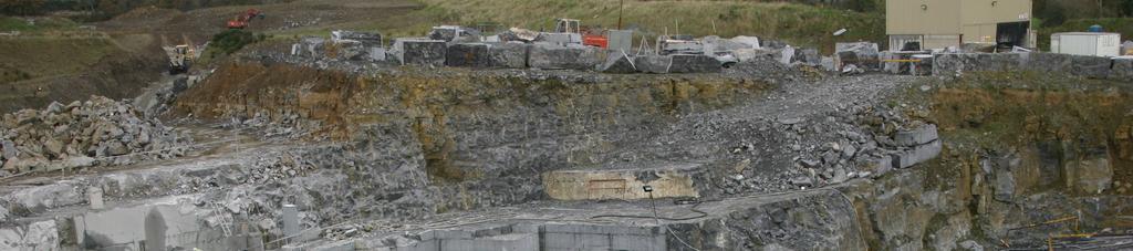
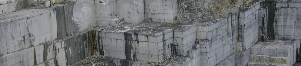
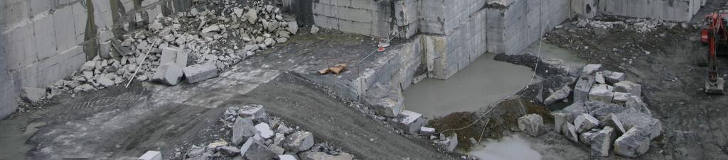
10 Groundwater Discharge from a Regionally Important Aquifer
11 Estimates of groundwater inflows to a number of rock quarries throughout Ireland. Aquitards Minor Aquifers Major Aquifers Estimates of late summer discharge rate (l/s) Approximate volume of rock extracted below W.T. (m 3 X10 6 )
 management of rainfall incident with the site, and 3) management of groundwater inflows to")
12 2. Management of Water in Quarries Water management falls into 3 catagories: 1) supply of potable and process water, 2) management of rainfall incident with the site, and 3) management of groundwater inflows to excavation

13 2.1 Water Supply The volumes required for potable water are of the order 5-10m 3 /day and can be supplied via mains or private source. Process waters are required for aggregate washing and dust suppression measures as well as ancillary facilities such as readymix plant. Volumes required tend to be m 3 /day depending on quarry output. The process waters are unlikely to be provided by mains and must be either abstracted from groundwater or recycled from run-off.

14 2.2 Water Management It is a requirement both from the planning authourity but also for operational efficiency that all run-off from site is controlled. Rainfall allowed to run-off must be attenuated to remove fines and contaminents prior to discharge. This is normally achieved using settlement lagoons and hydrocarbon interceptors.
15 2.2 Water Management (continued) A 25-year rainfall event will equate to mm rainfall falling over a 48hr period. For a typical medium sized quarry of 20ha this will generate run-off of c.7,000m 3 /day. The quarry void can be used as storage to retain waters incident with it. However, run-off from yard and process areas tend to be discharged during the event. This can equate to 1,000m 3 /day, which must be attenuated.
16 Cut off drain to reduce surface water ingress to quarry void
3.0 GEOLOGY AND HYDROGEOLOGY
 3.0 GEOLOGY AND HYDROGEOLOGY 3.1 Methodology The Geological Survey of Ireland (GSI) publication Geology of South Cork was consulted to establish the nature of the bedrock lithology and Quaternary sediments.
1 st Draft Tullamore GWB Description 6 th January 2004
 Hydrometric Area Local Authority 25 Brosna Offaly & Westmeath Co. Co. s Topography Tullamore GWB: Summary of Initial Characterisation. Associated surface water features Associated terrestrial ecosystem(s)
11/22/2010. Groundwater in Unconsolidated Deposits. Alluvial (fluvial) deposits. - consist of gravel, sand, silt and clay
 deposits. - consist of gravel, sand, silt and clay") Groundwater in Unconsolidated Deposits Alluvial (fluvial) deposits - consist of gravel, sand, silt and clay - laid down by physical processes in rivers and flood plains - major sources for water supplies
Groundwater in Unconsolidated Deposits Alluvial (fluvial) deposits - consist of gravel, sand, silt and clay - laid down by physical processes in rivers and flood plains - major sources for water supplies
Newcastle West GWB: Summary of Initial Characterisation.
 Newcastle West GWB: Summary of Initial Characterisation. Hydrometric Area Local Authorities 24 - Deel/ Shannon Estuary Limerick Co. Co. Topography Associated surface water features Rivers: Deel, Daar,
AGENDA ITEM 6 APPENDIX /0151/DET GROUND WATER & SURFACE WATER MANAGEMENT PLAN
 CAIRNGORMS NATIONAL PARK AUTHORITY Planning Committee Agenda Item 6 Appendix 18 12/10/2018 AGENDA ITEM 6 APPENDIX 18 2018/0151/DET GROUND WATER & SURFACE WATER MANAGEMENT PLAN Dalwhinnie Quarry Ground
Water Framework Directive. Groundwater Monitoring Programme. Site Information. Kiltrough PWS
 Water Framework Directive Groundwater Monitoring Programme Site Information Kiltrough PWS ImagePath1: Kiltrough PWS\17_009_Kiltough_P1_SiteLo cation.jpg This monitoring point is a well that is part of
Wisconsin s Hydrogeology: an overview
 2012 Soil and Water Conservation Society Conference Stevens Point, WI Feb 9, 2012 Wisconsin s Hydrogeology: an overview Ken Bradbury Wisconsin Geological and Natural History Survey University of Wisconsin-Extension
Prof. Stephen A. Nelson EENS 111. Groundwater
 Page 1 of 8 Prof. Stephen A. Nelson EENS 111 Tulane University Physical Geology This page last updated on 20-Oct-2003 is water that exists in the pore spaces and fractures in rock and sediment beneath
Water Framework Directive. Groundwater Monitoring Programme. Site Information. Galbally
 Water Framework Directive Groundwater Monitoring Programme Site Information Galbally ImagePath1: Galbally\Galbally1.jpg Galbally source is comprised of 2 boreholes situated in Devonian Old Red Sandstones
Groundwater Rebound in the South Yorkshire Coalfield: A review of initial modelling
 Groundwater Rebound in the South Yorkshire Coalfield: A review of initial modelling 1 S. P. Burke, 1 H. A.B. Potter and 2 A. Jarvis 1 Environment Agency: Science Group, Olton Court, Olton,Solihull UK 2
Groundwater. (x 1000 km 3 /y) Reservoirs. Oceans Cover >70% of Surface. Groundwater and the. Hydrologic Cycle
 Reservoirs. Oceans Cover >70% of Surface. Groundwater and the. Hydrologic Cycle") Chapter 13 Oceans Cover >70% of Surface Groundwater and the Hydrologic Cycle Oceans are only 0.025% of Mass Groundwater Groundwater is liquid water that lies in the subsurface in fractures in rocks and
Chapter 13 Oceans Cover >70% of Surface Groundwater and the Hydrologic Cycle Oceans are only 0.025% of Mass Groundwater Groundwater is liquid water that lies in the subsurface in fractures in rocks and
URBAN HYDROLOGY: WATER IN THE CITY OF TSHWANE Plant Sciences Auditorium, University of Pretoria January 2014 URBAN HYDROGEOLOGY
 URBAN HYDROLOGY: WATER IN THE CITY OF TSHWANE Plant Sciences Auditorium, University of Pretoria 23 24 January 2014 URBAN HYDROGEOLOGY MATTHYS A. DIPPENAAR DEPARTMENT GEOLOGY, UNIVERSITY OF PRETORIA HYDROGEOLOGY
DATA ACQUISITION METHODS FOR GROUNDWATER INVESTIGATION AND THE SITING OF WATER SUPPLY WELLS
 DATA ACQUISITION METHODS FOR GROUNDWATER INVESTIGATION AND THE SITING OF WATER SUPPLY WELLS M.B.J. Foster Tetra Tech EM Inc., San Francisco, CA, USA Keywords: Groundwater, water wells, drilled wells, geophysical
Oola PWS - Carrigmore BH
 Water Framework Directive Groundwater Monitoring Programme Site Information Oola PWS - Carrigmore BH ImagePath1: Oola PWS - Carrigmore BH\OolaPWSCarrigmore1.jpg Oola PWS Carrigmore BH is a borehole used
Finding Large Capacity Groundwater Supplies for Irrigation
 Finding Large Capacity Groundwater Supplies for Irrigation December 14, 2012 Presented by: Michael L. Chapman, Jr., PG Irrigation Well Site Evaluation Background Investigation Identify Hydrogeologic Conditions
Hydraulic Impacts of Limestone Quarries and Gravel Pits. Jeff Green Minnesota DNR-Division of Ecological & Water Resources
 Hydraulic Impacts of Limestone Quarries and Gravel Pits Jeff Green Minnesota DNR-Division of Ecological & Water Resources The Hydraulic Impacts of Limestone Quarries and Gravel Pits Study was funded by
Proposed Cemetery Thornhill Road. Tier One Hydrogeological Risk Assessment. Peter Mitchell Associates
 Proposed Cemetery Thornhill Road Tier One Hydrogeological Risk Assessment Peter Mitchell Associates January 2015 Executive Summary This report uses a desk-based risk assessment technique published by the
Evolution of the conceptual hydrogeologic and ground-water flow model for Las Vegas Valley, Clark County, Nevada
 Evolution of the conceptual hydrogeologic and ground-water flow model for Las Vegas Valley, Clark County, Nevada Geological Society of America Annual Meeting November 14, 2 David J. Donovan Southern Nevada
Soils, Hydrogeology, and Aquifer Properties. Philip B. Bedient 2006 Rice University
 Soils, Hydrogeology, and Aquifer Properties Philip B. Bedient 2006 Rice University Charbeneau, 2000. Basin Hydrologic Cycle Global Water Supply Distribution 3% of earth s water is fresh - 97% oceans 1%
Essentials of Geology, 11e
 Essentials of Geology, 11e Groundwater Chapter 10 Instructor Jennifer Barson Spokane Falls Community College Geology 101 Stanley Hatfield Southwestern Illinois Co Jennifer Cole Northeastern University
Groundwater. (x 1000 km 3 /y) Oceans Cover >70% of Surface. Groundwater and the. Hydrologic Cycle
 Oceans Cover >70% of Surface. Groundwater and the. Hydrologic Cycle") Chapter 17 Oceans Cover >70% of Surface Groundwater and the Hydrologic Cycle Vasey s Paradise, GCNP Oceans are only 0.025% of Mass Groundwater Groundwater is liquid water that lies in the subsurface in
Chapter 17 Oceans Cover >70% of Surface Groundwater and the Hydrologic Cycle Vasey s Paradise, GCNP Oceans are only 0.025% of Mass Groundwater Groundwater is liquid water that lies in the subsurface in
THE MINISTRY OF ENERGY AND ENERGY INDUSTRIES MINERALS DIVISION MINE DESIGN TEMPLATE OPERATOR NAME: OPERATOR ADDRESS: PHONE NUMBER: FACSIMILE:
 THE MINISTRY OF ENERGY AND ENERGY INDUSTRIES MINERALS DIVISION MINE DESIGN TEMPLATE 1.0 GENERAL INFORMATION OPERATOR NAME: OPERATOR ADDRESS: PHONE NUMBER: FACSIMILE: NAME OF CONTACT: CELLULAR PHONE: EMAIL
GEO-STABILITY DESKTOP STUDY FOR A PROPOSED FILLING STATION AT ROODEKRANS MOGALE CITY, GAUTENG
 GEO-STABILITY DESKTOP STUDY FOR A PROPOSED FILLING STATION AT ROODEKRANS MOGALE CITY, GAUTENG Page 1 of 11 GEO-STABILITY DESKTOP STUDY FOR A PROPOSED FILLING STATION AT ROODEKRANS MOGALE CITY, GAUTENG
resource and vulnerability Robineau & Join, nov
 Groundwater in tropical islands resource and vulnerability Robineau & Join, nov 2007 1 Diversity of hydrogeological environments in coastal areas of tropical islands : Hydrologic conditions (surface waters)
Appendix 8.1 Desktop Hydrogeological Assessment, Proposed Coolnabacky kV GIS Substation, Co. Laois
 Environmental Report Appendices for Laois-Kilkenny Reinforcement Project Appendix 8.1 esktop Hydrogeological Assessment, Proposed Coolnabacky 400-110kV GIS Substation, Co. Laois ESKTOP HYROGEOLOGICAL ASSESSMENT,
Dunkerrin - Guilfoyles Well
 Water Framework Directive Groundwater Monitoring Programme Site Information Dunkerrin - Guilfoyles Well ImagePath1: Dunkerrin - Guilfoyles Well\IE_SH_G_19_005_a_Pump House_(800_x_600).jpg Dunkerrin/ Guilfoyles
Chapter 14: Groundwater. Fig 14.5b
 Chapter 14: Groundwater Fig 14.5b OBJECTIVES Recognize that groundwater is a vital source of accessible freshwater. Describe how groundwater forms below the water table. Explain the origin of aquifers,
The Geology and Hydrogeology of the Spyhill Area
 The Geology and Hydrogeology of the Spyhill Area Clare North (WorleyParsons Komex) and Martin Ortiz (The City of Calgary) 2-Jul-08 Outline Background Site Location Existing Information New Work Geology
Chapter 14. Groundwater
 Chapter 14 Groundwater Importance of groundwater! Groundwater is water found in the pores of soil and sediment, plus narrow fractures in bedrock! Groundwater is the largest reservoir of fresh water that
Vu Ngoc Ky Academy of Mining and Geology Hanoi, Vietnam
 HYDROGEOLOGICAL CONDITIONS IN TiiE MAIN COAL BASINS OF VIETNAM Vu Ngoc Ky Academy of Mining and Geology Hanoi, Vietnam ABSTRACT Three problems are presented in the following paper: l.distribution and general
Groundwater Hydrology
 EXERCISE 12 Groundwater Hydrology INTRODUCTION Groundwater is an important component of the hydrologic cycle. It feeds lakes, rivers, wetlands, and reservoirs; it supplies water for domestic, municipal,
Impact of the Danube River on the groundwater dynamics in the Kozloduy Lowland
 GEOLOGICA BALCANICA, 46 (2), Sofia, Nov. 2017, pp. 33 39. Impact of the Danube River on the groundwater dynamics in the Kozloduy Lowland Peter Gerginov Geological Institute, Bulgarian Academy of Sciences,
Mark S. Nordberg Geology and Groundwater Investigations Section North Central Region Office California Department of Water Resources
 Mark S. Nordberg Geology and Groundwater Investigations Section North Central Region Office California Department of Water Resources Ukiah Drought Workshop July 29, 2009 Groundwater 101 Groundwater is
HYDROGEOLOGICAL PROPERTIES OF THE UG2 PYROXENITE AQUIFERS OF THE BUSHVELD COMPLEX
 R. Gebrekristos, P.Cheshire HYDROGEOLOGICAL PROPERTIES OF THE UG2 PYROXENITE AQUIFERS OF THE BUSHVELD COMPLEX R. Gebrekristos Digby Wells Environmental P. Cheshire Groundwater Monitoring Services Abstract
Cappog Bridge (PW-3)
") Water Framework Directive Groundwater Monitoring Programme Site Information Cappog Bridge (PW-3) ImagePath1: Cappog Bridge\IEGBNI_NB_G_012_18_0 01_A_SiteLocation.jpg Cappog Bridge PW-3 is one of 8 boreholes
Water Framework Directive Groundwater Monitoring Programme Site Information Cappog Bridge (PW-3) ImagePath1: Cappog Bridge\IEGBNI_NB_G_012_18_0 01_A_SiteLocation.jpg Cappog Bridge PW-3 is one of 8 boreholes
Pros and Cons against Reasonable Development of Unconventional Energy Resources
 Pros and Cons against Reasonable Development of Unconventional Energy Resources Associate Professor Shteryo LYOMOV, Ph.D. Presentation outline Energy resources; Conventional and Unconventional energy resources;
Groundwater in Bayfield County
 Groundwater in Bayfield County Presented to Bayfield County Large Scale Livestoc Study Committee April 23, 2015 Madeline Gotowitz Hydrogeologist Groundwater in Bayfield County Groundwater basics Hydrogeology
Delineation of Zones at Risk from Groundwater Inflows at an Underground Platinum Mine in South Africa
 Delineation of Zones at Risk from Groundwater Inflows at an Underground Platinum Mine in South Africa Mr Andreas Stoll andreas.stoll@erm.com Environmental Resources Management Swiss GmbH (ERM), Switzerland
Hydrodynamic Model of the Open-Pit Mine Buvač (Republic of Srpska)
") Hydrodynamic Model of the Open-Pit Mine Buvač (Republic of Srpska) Dušan Polomčić, Dragoljub Bajić*, Petar Papić, Jana Stojković University of Belgrade, Faculty of Mining and Geology, Department of Hydrogeology
Hydrodynamic Model of the Open-Pit Mine Buvač (Republic of Srpska) Dušan Polomčić, Dragoljub Bajić*, Petar Papić, Jana Stojković University of Belgrade, Faculty of Mining and Geology, Department of Hydrogeology
Water Framework Directive. Groundwater Monitoring Programme. Site Information. Tir na League
 Water Framework Directive Groundwater Monitoring Programme Site Information Tir na League ImagePath1: Tir na League\IE_NW_G_078_05_005_ A_PumpHouse.jpg Tir na League is an infiltration gallery situated
David de Courcy-Bower and Samuel Mohr
 Applicability and Limitations of LNAPL Transmissivity as a Metric within Bedrock Formations Insert then choose Picture select your picture. Right click your picture and Send to back. David de Courcy-Bower
Construction Technical Specifications on Rock-Foundation Excavating Engineering of Hydraulic Structures
 DL Electric Power Industry Standard of the People's Republic of China P DL I T 5389-- Construction Technical Specifications on Rock-Foundation Excavating Engineering of Hydraulic Structures DL/T 5389-
The Capitan Aquifer - Ellenburger Production Wells Geothermal Engine Source?
 GEOTHERMAL ENERGY UTILIZATION ASSOCIATED WITH OIL & GAS DEVELOPMENT June 17-18, 2008 Southern Methodist University Dallas, Texas The Capitan Aquifer - Ellenburger Production Wells Geothermal Engine Source?
Florida s Karst Geology
 Florida s Karst Geology Orange Creek Basin Interagency Working Group Public Workshop, November 5 th, 2015 Harley Means, P.G. Assistant State Geologist Florida Geological Survey Karst Karst a type of topography
Hydrogeology of Karst NE Wisconsin. Dr. Maureen A. Muldoon UW-Oshkosh Geology Department
 Hydrogeology of Karst NE Wisconsin Dr. Maureen A. Muldoon UW-Oshkosh Geology Department WI Bedrock Outline Karst Landscapes Existing WQ Data Flow in Karst Aquifers Overview of Silurian Aquifer Water Level
Differentiation of chloride source using stable chlorine isotopes
 Differentiation of chloride source using stable chlorine isotopes RemTech 2009 Banff, Alberta October 14-16 2009 Dr. Alec Blyth and Tom Anthony 1 1 currently City of Calgary Background: DOW Chemical Canada
3.5 SOILS, GEOLOGY AND HYDROGEOLOGY
 3.5 SOILS, GEOLOGY AND HYDROGEOLOGY 3.5.1 INTRODUCTION 3.5.1.1 This chapter of the describes the Soils, Geology and Hydrogeology in the existing environment surrounding the proposed development. This chapter
A BOOKLET ON. T Rangasamy, A R Leach and A P Cook. Facilitating safety and health research in the South African mining industry
 A BOOKLET ON THE HYDRAULIC DESIGN OF COAL BARRIER PILLARS T Rangasamy, A R Leach and A P Cook Facilitating safety and health research in the South African mining industry A BOOKLET ON THE HYDRAULIC DESIGN
Physiographic zones. and water quality
 Southland Physiographic zones bedrock/hill country Technical information Physiographic zones are part of the Water and Land 2020 & Beyond project that aims to maintain and improve water quality in the
THIS IS A NEW SPECIFICATION
 THIS IS A NEW SPECIFICATION ADVANCED GCE GEOLOGY Environmental Geology F794 * OCE / 12353* Candidates answer on the Question Paper OCR Supplied Materials: None Other Materials Required: Ruler (cm/mm) Thursday
GEOL Introductory Geology: Exploring Planet Earth Fall 2010 Test #2 October 18, 2010
 GEOL 101 - Introductory Geology: Exploring Planet Earth Fall 2010 Test #2 October 18, 2010 Name KEY ID# KEY Multiple choice questions (2 points each). 1. What type of metamorphic rock is formed over large
MAPPING GROUNDWATER VULNERABILITY IN SCOTLAND: A NEW APPROACH FOR THE WATER FRAMEWORK DIRECTIVE
 MAPPING GROUNDWATER VULNERABILITY IN SCOTLAND: A NEW APPROACH FOR THE WATER FRAMEWORK DIRECTIVE B E Ó Dochartaigh 1, D F Ball 1, A M MacDonald 1, A Lilly 2, V Fitzsimons 3, M del Rio 1 and C A Auton 1
SEASONAL WATER STORAGE AND REPLENISHMENT OF A FRACTURED GRANITE AQUIFER USING ASR WELLS
 SEASONAL WATER STORAGE AND REPLENISHMENT OF A FRACTURED GRANITE AQUIFER USING ASR WELLS Mario R. Lluria; Phillip M. Paski; Gary G. Small HydroSystems, Incorporated Phoenix, Arizona USA Presentation Contents
INTRODUCTION Water resources are vitally important for the future of humankind. Groundwater from karst aquifers is among the most important drinking w
 Vulnerability Mapping for the Protection of Carbonate (Karst) Aquifers (Ramallah-Al Bireh District) Eng. Amjad da Assi House of fw Water and de Environment May, 2007 INTRODUCTION Water resources are vitally
Karst found mostly in limestone (rock with at least 50% carbonate minerals), depends on 1) permeability & porosity
, depends on 1) permeability & porosity") KARST LANDFORMS produced by weathering & erosion in regions of carbonate rocks and evaporites processes called karstification mainly below ground surface predominantly underground drainage poorly-developed
KARST LANDFORMS produced by weathering & erosion in regions of carbonate rocks and evaporites processes called karstification mainly below ground surface predominantly underground drainage poorly-developed
iii CONTENTS vii ACKNOWLEDGMENTS EXECUTIVE SUMMARY INTRODUCTION Study Area Data Sources Preparation of Geologic Maps
 CONTENTS ACKNOWLEDGMENTS EXECUTIVE SUMMARY INTRODUCTION Study Area Data Sources Preparation of Geologic Maps GEOLOGY Bedrock Geology Succession and Distribution Structural Features Description of Bedrock
An Hypothesis Concerning a Confined Groundwater Zone in Slopes of Weathered Igneous Rocks
 Symposium on Slope Hazards and Their Prevention: 8-10 May, 2000, Hong Kong, PRC An Hypothesis Concerning a Confined Groundwater Zone in Slopes of Weathered Igneous Rocks J. J. Jiao and A. W. Malone Department
Numerical modeling of mine dewatering and flooding in the Evander Gold Basin, South Africa
 Numerical modeling of mine dewatering and flooding in the Evander Gold Basin, South Africa Abstract K.T. Witthüser 1, M. Holland 1, T. Seidel 2, and C.M. König 2 1 Delta-H Water Systems Modelling Pretoria,
Using transmissivity, specific capacity and borehole yielddata to assess the productivity of Scottish aquifers
 Using transmissivity, specific capacity and borehole yielddata to assess the productivity of Scottish aquifers M.T. Graham, D.F. Ball, B.É. Ó Dochartaigh* & A.M. MacDonald British Geological Survey, Murchison
 12 10 8 6 4 2 0 40-50 50-60 60-70 70-80 80-90 90-100 Fresh Water What we will cover The Hydrologic Cycle River systems Floods Groundwater Caves and Karst Topography Hot springs Distribution of water in
WESTCARB Phase I Results Review
 WESTCARB Phase I Results Review Arizona Geologic Characterization Errol Montgomery Principal Errol L. Montgomery & Associates (520) 881-4912 emontgomery@elmontgomery.com November 9, 2005 Site Characterization
Groundwater Resources of Missouri. Cynthia Brookshire, R. G.
 Groundwater Resources of Missouri Cynthia Brookshire, R. G. GROUNDWATER... Water beneath the Earth s surface within a zone of saturation AQUIFER... A geologic formation or group of formations that are
Water Framework Directive. Groundwater Monitoring Programme. Site Information. Drum Bingahamstown
 Water Framework Directive Groundwater Monitoring Programme Site Information Drum Bingahamstown ImagePath1: Drum Bingahamstown\IE_WE_G_16_ 1_a_Spring.jpg Drum Binghamstown is a spring that is used for a
Why Study Groundwater?
 Groundwater Water filling open spaces in rock, sediment, and soil beneath the surface is called groundwater. This natural resource is as important to human endeavors as surface water. Groundwater is an
IAEA SAFETY STANDARDS Geotechnical Aspects of Site Evaluation and Foundations in NPPs, NS-G-3.6
 IAEA SAFETY STANDARDS Geotechnical Aspects of Site Evaluation and Foundations in NPPs, NS-G-3.6 Regional Workshop on Volcanic, Seismic, and Tsunami Hazard Assessment Related to NPP Siting Activities and
FUNDAMENTALS OF ENGINEERING GEOLOGY
 FUNDAMENTALS OF ENGINEERING GEOLOGY Prof. Dr. HUSSEIN HAMEED KARIM Building and Construction Engineering Department 2012 Preface The impulse to write this book stemmed from a course of geology given by
Lab 9: Petroleum and groundwater
 Geology 101 Name(s): Lab 9: Petroleum and groundwater Petroleum (oil) is a multi-component liquid refined to generate different hydrocarbons, such as heptane (a component of gasoline) and waxes. For the
University of Pretoria. Matthys Dippenaar and Louis van Rooy Engineering Geology and Hydrogeology, Geology Department July 2017, Livingstone, Zambia
 University of Pretoria Contributions to the Characterisation of the Vadose Zone f or Hydrogeological and Geotechnical Applications Matthys Dippenaar and Louis van Rooy Engineering Geology and Hydrogeology,
PRECAMBRIAN CRYSTALLINE AQUIFER (METAMORPHIC ROCKS)
") HAYWARD QUADRANGLE: Groundwater Production by Aquifer In the 56-square-mile area of the Hayward Quadrangle, groundwater is produced from metamorphic crystalline rocks of the Precambrian basement (in the
HAYWARD QUADRANGLE: Groundwater Production by Aquifer In the 56-square-mile area of the Hayward Quadrangle, groundwater is produced from metamorphic crystalline rocks of the Precambrian basement (in the
Scholars Research Library
 Available online at www.scholarsresearchlibrary.com Scholars Research Library Archives of Physics Research, 2010, 1 (2):37-45 (http://scholarsresearchlibrary.com/archive.html) ISSN 0976-0970 2-D Resistivity
HOW. HOW vehicle mounted units portable units also available. HOW, WHEN & WHY to Geophysically Log in S.I.?
 HOW, WHEN & WHY to Geophysically Log in S.I.? by Kim Beesley HOW HOW vehicle mounted units portable units also available Access to borehole Depth of borehole sump / rat -hole? 1 HOW? - subject to borehole
Galilee Basin Mining and Groundwater
 Galilee Basin Mining and Groundwater Impact on the Great Artesian Basin John Hillier Acknowledgements Some diagrams used in this presentation have been obtained from: EIS for proposed mining ventures A
Clones Public Water Supply Scotshouse Boreholes
 Clones Public Water Supply Scotshouse Boreholes Groundwater Source Protection Zones Prepared by: Melissa Swartz Geological Survey of Ireland Assisted by: Donal Daly, Geological Survey of Ireland Vincent
How to Identify and Properly Classify Drill Cuttings
 How to Identify and Properly Classify Drill Cuttings (Creating Useful Borehole Logs) Dave Larson Hydrogeology and Geophysics Section Accurate information about the borehole location and a careful description
For inspection purposes only.
 Pfizer Biotechnology Ireland Pfizer Monoclonal Antibodies Small Scale Facility IPPC Licence Application ATTACHMENT I.5 Hydrogeological Desk Study (URS 2008) J:\C2000-C2099\C2054\3) DOCUMENTS\40\REPORTS\IPPC
SASKATCHEWAN STRATIGRAPHY GLACIAL EXAMPLE BOULDERS IN GLACIAL DEPOSITS
 SASKATCHEWAN STRATIGRAPHY GLACIAL EXAMPLE BOULDERS IN GLACIAL DEPOSITS 51 SASKATCHEWAN STRATIGRAPHY GLACIAL SURFICIAL STRATIFIED DEPOSITS 52 SASKATCHEWAN STRATIGRAPHY GLACIAL EXAMPLE OF SEDIMENT DEPOSITION
GPR survey and field work summary in Siilinjärvi mine during July 2014
 GEOLOGICAL SURVEY OF FINLAND Groundwater Espoo 21.6.2016 67/2016 GPR survey and field work summary in Siilinjärvi mine during July 2014 Samrit Luoma, Juha Majaniemi, Tiina Kaipainen, and Antti Pasanen
 http://dx.doi.org/10/1061/40698(2003)19 Green, J., Pavlish, J., Leete, J., and Alexander, Jr., E. (2003) Quarrying Impacts on Groundwater Flow Paths. Sinkholes and the Engineering and Environmental Impacts
Characterisation of Quaternary deposits in West Cumbria using the concept of domains: A case study
 Characterisation of Quaternary deposits in West using the concept of domains: a case study Characterisation of Quaternary deposits in West using the concept of domains: A case study Jon Merritt Quaternary
How & Where does infiltration work? Summary of Geologic History Constraints/benefits for different geologic units
 June 26, 2007: Low Impact Development 1 Associated Earth Sciences, Inc. Associated Earth Sciences, Inc. Presented by: Matthew A. Miller, PE April 24, 2012 How & Where does infiltration work? Summary of
HYDROGEOLOGICAL CONCEPTUAL MODEL OF A COMPLEX AQUIFER SYSTEM CENTRAL KALAHARI BASIN (BOTSWANA) DATE: 27 OCTOBER 2016 VENUE: GICC
 DATE: 27 OCTOBER 2016 VENUE: GICC") HYDROGEOLOGICAL CONCEPTUAL MODEL OF A COMPLEX AQUIFER SYSTEM CENTRAL KALAHARI BASIN (BOTSWANA) DATE: 27 OCTOBER 2016 VENUE: GICC MR. M. LEKULA DR. M.W. LUBCZYNSKI PROF. E.M. SHEMANG PRESENTATION OUTLINE
HYDROGEOLOGICAL CONCEPTUAL MODEL OF A COMPLEX AQUIFER SYSTEM CENTRAL KALAHARI BASIN (BOTSWANA) DATE: 27 OCTOBER 2016 VENUE: GICC MR. M. LEKULA DR. M.W. LUBCZYNSKI PROF. E.M. SHEMANG PRESENTATION OUTLINE
Cape Cross Salt Works PO Box 81307, Windhoek, Namibia. FINAL REPORT rev1 NHN170 NOVEMBER 2016
 Cape Cross Salt Works PO Box 81307, Windhoek, Namibia GROUNDWATER EXPLORATION FOR SUPPLY TO THE CAPE CROSS SALT WORKS FINAL REPORT rev1 NHN170 NOVEMBER 2016 Namib Hydrosearch, PO Box 11546 Windhoek Namibia,
Mine Dewatering in a Compartmentalized Hydrogeologic Setting at Sishen Mine in South Africa
 Golden CO; USA Reliable Mine Water Technology IMWA 2013 Mine Dewatering in a Compartmentalized Hydrogeologic Setting at Sishen Mine in South Africa Houmao Liu¹, Elaine Nel², Johanita Kotze³, Dong Ding4
What we will cover. The Hydrologic Cycle. River systems. Floods. Groundwater. Caves and Karst Topography. Hot springs
 Fresh Water What we will cover The Hydrologic Cycle River systems Floods Groundwater Caves and Karst Topography Hot springs On a piece of paper, put these reservoirs of water in to order from largest to
AWRA PMAS Engineers Club of Philadelphia. A Geologic Perspective on Stormwater
 AWRA PMAS Engineers Club of Philadelphia A Geologic Perspective on Stormwater Toby J. Kessler, P.G. Hydrogeologist Trevor G. Woodward, P.G. Engineering Geologist September 10, 2014 Gilmore & Associates,
Draft 1 Curlew Mountains 3 rd October 2003
 Curlew Mountains Southeast: Summary of Initial Characterisation. OUTSTANDING ISSUES the volcanic rocks within the Keadew Formation/Basalts and other volcanic rocks Andesitic Lava. Is the pure basis of
INVESTIGATIONS OF LARGE SCALE SINKHOLE COLLAPSES, LAIBIN, GUANGXI, CHINA
 INVESTIGATIONS OF LARGE SCALE SINKHOLE COLLAPSES, LAIBIN, GUANGXI, CHINA Yongli Gao Department of Geological Sciences, Center for Water Research, University of Texas at San Antonio, TX 78249, USA, yongli.gao@utsa.edu
THIS IS A NEW SPECIFICATION
 THIS IS A NEW SPECIFICATION ADVANCED GCE GEOLOGY Environmental Geology F794 * OCE / 12441* Candidates answer on the Question Paper OCR Supplied Materials: None Other Materials Required: Electronic calculator
Monday 2 June 2014 Morning
 Monday 2 June 2014 Morning A2 GCE GEOLOGY F794/01 Environmental Geology *3076922876* Candidates answer on the Question Paper. OCR supplied materials: None Other materials required: Electronic calculator
RIPRAP ASSESSMENT VARIOUS SITES HWY 40 NEAR GRANDE CACHE, AB
 RIPRAP ASSESSMENT VARIOUS SITES HWY 40 NEAR GRANDE CACHE, AB Need for Riprap Increased traffic along Hwy 40 has generated a lot of construction projects to upgrade highway Lack of good quality heavy rock
Geology 101, Spring 2008
 Geology 101, Spring 2008 Name(s): Lab 10: Groundwater and resource extraction Groundwater As many parts of the world are becoming increasingly aware, groundwater is an economic resource, as strategic and
Water Framework Directive (WFD) River Basin District Management Systems APPROACH TO DELINEATION OF GROUNDWATER BODIES
 River Basin District Management Systems APPROACH TO DELINEATION OF GROUNDWATER BODIES") Water Framework Directive (WFD) River Basin District Management Systems APPROACH TO DELINEATION OF GROUNDWATER BODIES Paper by the Working Group on Groundwater Guidance document no. GW2 This is a guidance
Water Framework Directive (WFD) River Basin District Management Systems APPROACH TO DELINEATION OF GROUNDWATER BODIES Paper by the Working Group on Groundwater Guidance document no. GW2 This is a guidance
10. GEOTECHNICAL EXPLORATION PROGRAM
 Geotechnical site investigations should be conducted in multiple phases to obtain data for use during the planning and design of the tunnel system. Geotechnical investigations typically are performed in
Chapter 8 Fetter, Applied Hydrology 4 th Edition, Geology of Groundwater Occurrence
 Chapter 8 Fetter, Applied Hydrology 4 th Edition, 2001 Geology of Groundwater Occurrence Figure 8.42. Alluvial Valleys ground-water region. Fetter, Applied Hydrology 4 th Edition, 2001 Fetter, Applied
IMWA Proceedings 1987 International Mine Water Association
 COAL MINE DEWATERING AS A KEY ASPECT IN PRE-MINE FEASIBILITY PLANNING IN THE SEMI-ARID WESTERN UNITED STATES Phillip E. Brown Consultant in Geohydrology 1401 Monaco Parkway Denver, Colorado 87220 USA Marcie
Land subsidence due to groundwater withdrawal in Hanoi, Vietnam
 Land Subsidence (Proceedings of the Fifth International Symposium on Land Subsidence, The Hague, October 1995). 1AHS Publ. no. 234, 1995. 55 Land subsidence due to groundwater withdrawal in Hanoi, Vietnam
International Workshop on Groundwater Systems in Europe, August, 2013 Berlin
 Hydrogeological Mapping in Albania From the IHME contribution to larger scale national maps R. Eftimi, I. Tafilaj, G. Bisha & Xh. Sheganaku Mali me Gropa karst plateau Selita spring The hydrogeological
Lecture 15: Subsidence
 Lecture 15: Subsidence Key Questions 1. How does removal of groundwater cause subsidence on a regional scale? 2. Under what conditions does a building sink into sediment? 3. Why do clays consolidate more
RIVERS, GROUNDWATER, AND GLACIERS
 RIVERS, GROUNDWATER, AND GLACIERS Delta A fan-shaped deposit that forms when a river flows into a quiet or large body of water, such as a lake, an ocean, or an inland sea. Alluvial Fan A sloping triangle
Supplementary expert report on groundwater impacts to the Land Court by Dr John Webb
 Coast and Country Association of Queensland Inc. & Ors ats Hancock Coal Pty Ltd, Land Court of Queensland Proceeding MRA713-13 & EPA714-13 Objection to Mining lease and Environmental Authority for Kevin