Napa County Comprehensive Groundwater Monitoring Program 2015 Annual Report and CASGEM Update
|
|
|
- Suzanna Nicholson
- 5 years ago
- Views:
Transcription


1 Napa County Comprehensive Groundwater Monitoring Program 2015 Annual Report and CASGEM Update April 21, 2016 Watershed Information & Conservation Council By Vicki Kretsinger Grabert
2 Overview Evolving groundwater monitoring program Background Highlights 2015 Annual Report GW-SW interaction GW Quality Summary and next steps
3 Groundwater Basins Napa Sonoma Valley Basin Napa Valley Subbasin Napa-Sonoma Lowlands Subbasin Berryessa Valley Basin Pope Valley Basin Suisun-Fairfield Valley Basin The MST is located largely outside of DWRdesignated basins.

")
 Suisun-Fairfield Valley")
4 Groundwater Basins: Initial SGMA Prioritization Napa Sonoma Valley Basin Napa Valley Subbasin (Med) Napa-Sonoma Lowlands Subbasin (VL) Berryessa Valley Basin(VL) Pope Valley Basin(VL) Suisun-Fairfield Valley Basin(VL) Medium Very Low

5 Napa Subareas 17 Subareas Napa Valley Floor includes 5 Subareas Based on: Watershed Boundaries Groundwater Basins Planning Subareas


6 Subsurface Geology Very Complex in Napa Valley Especially Complex in Hillsides Sedimentary Alluvium Sonoma Volcanics 6

7 Water Budget: Core Element of Groundwater Sustainability Inflows Outflows = S Change in GW Storage 7


8 Water Budgets Involve More than the Groundwater Basin Precipitation: PRISM 800 Meter Grid Watershed: Upper Napa River Near Napa

 Pumping: ~21,300 AF/yr (2004) LSCE and MBK, Napa Hydrogeologic Characterization, 2013 Estimated")
9 New Climate Ready Study (including future scenarios) Pepperwood Preserve (January 2016): Avg. Annual Recharge 76,678 AF Watershed Water Budget: Napa River Near Napa Precipitation: >400,000 AF/Yr (Avg.) Recharge: ~ 70,600 AF/Yr (Avg.) Pumping: ~21,300 AF/yr (2004) LSCE and MBK, Napa Hydrogeologic Characterization, 2013 Estimated Groundwater Pumping: 21,300 acrefeet (2050 Study; Upper Napa Valley)
10 Water Budgets Sustainable Groundwater Management Act (SGMA) likely to require for Plans Updated water budgets already underway for Napa Valley Subbasin Over hydrologic base period Represent different water year types (drier, normal, wetter) Current Future
11 GROUNDWATER CONDITIONS: Highlights 2015 Annual Report Focus is on monitoring results Different from SGMA efforts
12 Groundwater Elevation (ft., msl) Precipitation (in.) Groundwater Conditions: Napa Valley Subbasin Dry Years St. Helena Yountville Napa 60 Napa Precipitation

 DWR, 4")
13 GW Level Monitoring, 2015 Napa Co., 100 (incld. 48 volun., 10 SW/GW) DWR, 4 GeoTracker, 9 Total Wells = 113 Sites


14 Groundwater Monitoring Direct Connection Can Contribute to Streamflow Courtesy TNC Unconfined Indirect Connection Stream Seepage Independent of GW Levels Confined Courtesy TNC


15 Depth to Groundwater Feet below ground surface 0 to 10 ft Water table (Valley Floor) generally very shallow; basin quite full 15

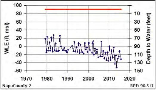
16 MST Subarea 16


17 Northeast Napa Area: Spring 2015
18 Groundwater/Surface Water Interaction
19 Historical Observations (USGS WRI 13-73, 1973) Historically, streamflows in Napa Valley varied considerably season to season and year to year Changes relatively large because of large seasonal variations in rainfall GW levels not changed significantly over time During periods of limited precipitation, GW levels declined and stream discharges reduced significantly.


20 Historical Days of No Streamflow Conn Creek near Oakville 1930s 1940s 1970s Napa River near Napa 1930s 1960s 1970s
 ranged from 16 34 ft [20ft at St.")
21 Surface Water/ 5 Groundwater Monitoring at 5 Sites Shallow MWs each site Levels & quality Stream gauge each site Streamflow & quality Depths to water (when drilled) ranged from ft [20ft at St. Helena]


22 GW Monitoring Wells Near River 2-inch dia. casings Looking Down at MWs Sand and Gravel Above Ground Locked Protection Below Ground Nested Monitoring Wells 40 ft Deep 2-inch dia. casings Not to Scale Sand 100 ft Deep

23 SW/GW Interaction: Site 5: St. Helena, Oct & Dec D S ft WL Elev., msl December ft ft October ft 40ft TD Elevation of Thalweg ft, msl GW above in Dec ftTD Not drawn to scale GW below in Oct. 2014

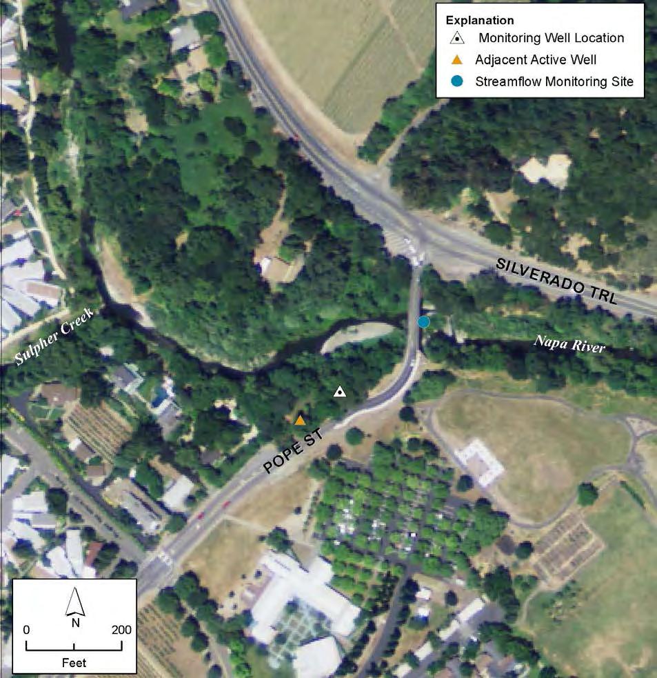


24 SW/GW Interaction: Site 5 St. Helena River Monitoring Active Supply Well GW Monitoring
25 SW/GW Interaction: Site 5 St. Helena Not to Scale River Streambed Shallow MW Deep MW WL Difference Shallow and Deep Oct = 17 ft.
26 SW/GW Interaction: Site 4 Yountville Shallow MW Deep MW Streambed River
27 SW/GW Site 4 Compared to Historical GW Levels Napa County-133: 120 ft deep spring manual measurements (orange), all other manual measurements (black) 133: October 2015 Shallow & Deep MWs Near River Precipitation (in.) Napa Precipitation Different Scale


28 GW Quality Data 78 Sites Additional Countysampled sites recommended


29 Nitrate Low NO 3 -N conc. MCL = 10 mg/l
30 TDS Generally low TDS VF May be susceptible to seawater intrusion from San Pablo Bay Elevated chloride, EC/TDS levels TDS much higher on avg south of VF than in the VF Probably originates from connate water in marine rocks; tidal influence Secondary MCL= 500/1,000 mg/l
 Generally stable")
31 TDS Trends Long historical records (from 1960/70s) Generally stable trends
32 Summary of GW Quality Conditions Generally Good GW Quality Selected Areas of Nat ly Occurring Elevated Constituents Calistoga Area of the Napa Valley Floor Geothermal influences Southern Napa County Elevated TDS and Chloride; likely naturally occurring; need additional monitoring to evaluate trends 32
: GW levels in")


33 Summary GW level trends stable majority of wells Napa Valley Floor Year-to-year declines observed in a few wells DWR (Update 2013): GW levels in well on VF, stable trend is generally indicative of wells located within the Napa Valley area Some response to drought conditions GW level declines in MST mostly moderated since 2008 Overall, on a basin wide scale, groundwater conditions in the Napa Valley Subbasin are good and similar to conditions reported decades ago.


34 Napa County and Next Steps Towards Groundwater Sustainability Ongoing (and evolving) SW and GW monitoring NE Napa area study Enhancing understanding of SW/GW interaction Conducting education and outreach Sustainable Groundwater Management Act, work in progress Water budgets, different water year types Water Education Foundation Groundwater Tour, Fall 2015

35 Thank You

36 Northeast Napa Study Area MST Area

37 North Napa

38 South Napa
Napa Valley Groundwater Sustainability: A Basin Analysis Report for the Napa Valley Subbasin
 Napa Valley Groundwater Sustainability: A Basin Analysis Report for the Napa Valley Subbasin December 13, 2016 Napa County Board of Supervisors By Vicki Kretsinger Grabert and Reid Bryson Basin Analysis
Napa Valley Groundwater Sustainability: A Basin Analysis Report for the Napa Valley Subbasin
 Napa Valley Groundwater Sustainability: A Basin Analysis Report for the Napa Valley Subbasin A report prepared pursuant to California Water Code Section 10733.6(b)(3) EXECUTIVE SUMMARY (354.4(A)) 1 1.0
Mark S. Nordberg Geology and Groundwater Investigations Section North Central Region Office California Department of Water Resources
 Mark S. Nordberg Geology and Groundwater Investigations Section North Central Region Office California Department of Water Resources Ukiah Drought Workshop July 29, 2009 Groundwater 101 Groundwater is
DRAFT. REVISED Draft. Paso Robles Subbasin Groundwater Sustainability Plan Chapter 6
 REVISED Draft Paso Robles Subbasin Groundwater Sustainability Plan Chapter 6 Prepared for the Paso Robles Subbasin Cooperative Committee and the Groundwater Sustainability Agencies February 14, 2019 Paso
January 25, Summary
 January 25, 2013 Summary Precipitation since the December 17, 2012, Drought Update has been slightly below average in parts of central and northern Illinois and above average in southern Illinois. Soil
REDWOOD VALLEY SUBAREA
 Independent Science Review Panel Conceptual Model of Watershed Hydrology, Surface Water and Groundwater Interactions and Stream Ecology for the Russian River Watershed Appendices A-1 APPENDIX A A-2 REDWOOD
Hydrogeology and Simulated Effects of Future Water Use and Drought in the North Fork Red River Alluvial Aquifer: Progress Report
 Hydrogeology and Simulated Effects of Future Water Use and Drought in the North Fork Red River Alluvial Aquifer: Progress Report Developed in partnership with the Oklahoma Water Resources Board S. Jerrod
Cuyama Basin North Fork Vineyard
 Cuyama Basin North Fork Vineyard Company Background plus Data Insights to Support GSP Development for the Cuyama Basin Presented by Grapevine Capital Partners and Cleath-Harris Geologists April 26th, 2018
Illinois Drought Update, December 1, 2005 DROUGHT RESPONSE TASK FORCE Illinois State Water Survey, Department of Natural Resources
 Illinois Drought Update, December 1, 2005 DROUGHT RESPONSE TASK FORCE Illinois State Water Survey, Department of Natural Resources For more drought information please go to http://www.sws.uiuc.edu/. SUMMARY.
Wisconsin s Hydrogeology: an overview
 2012 Soil and Water Conservation Society Conference Stevens Point, WI Feb 9, 2012 Wisconsin s Hydrogeology: an overview Ken Bradbury Wisconsin Geological and Natural History Survey University of Wisconsin-Extension
2. PHYSICAL SETTING FINAL GROUNDWATER MANAGEMENT PLAN. 2.1 Topography. 2.2 Climate
 FINAL GROUNDWATER MANAGEMENT PLAN 2. PHYSICAL SETTING Lassen County is a topographically diverse area at the confluence of the Cascade Range, Modoc Plateau, Sierra Nevada and Basin and Range geologic provinces.
Hydrogeology of Karst NE Wisconsin. Dr. Maureen A. Muldoon UW-Oshkosh Geology Department
 Hydrogeology of Karst NE Wisconsin Dr. Maureen A. Muldoon UW-Oshkosh Geology Department WI Bedrock Outline Karst Landscapes Existing WQ Data Flow in Karst Aquifers Overview of Silurian Aquifer Water Level
The mountain is permeable and fractured: Hydrological Connectivity in the Laramie Range
 WyCHEG Interest Group Meeting, Oct 30, 2017, Laramie, WY The mountain is permeable and fractured: Hydrological Connectivity in the Laramie Range Ye Zhang 1, Brad Carr 1, Shuangpo Ren 2, Andy Parsekian
Chiang Rai Province CC Threat overview AAS1109 Mekong ARCC
 Chiang Rai Province CC Threat overview AAS1109 Mekong ARCC This threat overview relies on projections of future climate change in the Mekong Basin for the period 2045-2069 compared to a baseline of 1980-2005.
MEMORANDUM. Jerry Conrow, Ojai Basin Groundwater Management Agency
 MEMORANDUM TO: FROM: Jerry Conrow, Ojai Basin Groundwater Management Agency Gregory Schnaar, PhD, Stephen J. Cullen, PhD, PG, DATE: August 6, 2014, 2014 SUBJECT: Ojai Basin Groundwater Model - Extended
LAUREL MARCUS California Land Stewardship Institute OVERVIEW OF GROUNDWATER STUDIES IN THE RUSSIAN RIVER WATERSHED
 LAUREL MARCUS California Land Stewardship Institute OVERVIEW OF GROUNDWATER STUDIES IN THE RUSSIAN RIVER WATERSHED - 60% OF LAND AREA } 20% OF LAND AREA } 20% OF LAND AREA GEOLOGY OF THE RUSSIAN RIVER
TECHNICAL MEMORANDUM: MADERA SUBBASIN. Sustainable Groundwater Management Act (SGMA) DRAFT PRELIMINARY BASIN BOUNDARY WATER BUDGET.
 DRAFT PRELIMINARY BASIN BOUNDARY WATER BUDGET.") TECHNICAL MEMORANDUM: MADERA SUBBASIN Sustainable Groundwater Management Act (SGMA) DRAFT PRELIMINARY BASIN BOUNDARY WATER BUDGET Prepared by February 2018 DRAFT PRELIMINARY Technical Memorandum: Madera
TECHNICAL MEMORANDUM: MADERA SUBBASIN Sustainable Groundwater Management Act (SGMA) DRAFT PRELIMINARY BASIN BOUNDARY WATER BUDGET Prepared by February 2018 DRAFT PRELIMINARY Technical Memorandum: Madera
3.1 Basin Description
 Chapter 3 3.1 Basin Description A description of the Study Area is provided in Bulletin 118 (California Department of Water Resources, 2003) with a significant portion of that description reprinted below
Technical Memorandum. 1 Study Area. Interbasin Groundwater Flow Evaluation
 Technical Memorandum Interbasin Groundwater Flow Evaluation Subject: Prepared For: Butte County Department of Water and Resource Conservation Prepared by: Sara Miller and Craig Altare, P.G. Reviewed by:
Sacramento Valley Groundwater Basin, Sutter Subbasin
 Sacramento Valley Groundwater Basin, Sutter Subbasin Groundwater Basin Number: 5-21.62 County: Sutter Surface Area: 234,400 acres (366 square miles) Boundaries and Hydrology The Sutter Subbasin lies in
Tule Subbasin: Sustainable Groundwater Management Act (SGMA) August 24, 2016 David De Groot, Professional Engineer 4Creeks, Inc.
 August 24, 2016 David De Groot, Professional Engineer 4Creeks, Inc.") Tule Subbasin: Sustainable Groundwater Management Act (SGMA) August 24, 2016 David De Groot, Professional Engineer 4Creeks, Inc. Overview 1 SUSTAINABLE GROUNDWATER MANAGEMENT ACT 2 TECHNICAL OVERVIEW OF
Tule Subbasin: Sustainable Groundwater Management Act (SGMA) August 24, 2016 David De Groot, Professional Engineer 4Creeks, Inc. Overview 1 SUSTAINABLE GROUNDWATER MANAGEMENT ACT 2 TECHNICAL OVERVIEW OF
12 SWAT USER S MANUAL, VERSION 98.1
 12 SWAT USER S MANUAL, VERSION 98.1 CANOPY STORAGE. Canopy storage is the water intercepted by vegetative surfaces (the canopy) where it is held and made available for evaporation. When using the curve
East Bay Plain Basin. EBMUD & City of Hayward. Groundwater Reliability Partnership Meeting March 22, 2017
 East Bay Plain Basin EBMUD & City of Hayward Groundwater Reliability Partnership Meeting March 22, 2017 Agenda Overview of the East Bay Plain Basin EBMUD s Bayside Groundwater Project EBMUD s Activities
Great Lakes Update. Volume 193: 2015 January through June Summary. Vol. 193 Great Lakes Update August 2015
 Great Lakes Update Volume 193: 2015 January through June Summary The U.S. Army Corps of Engineers (USACE) monitors the water levels of each of the Great Lakes. This report provides a summary of the Great
WORKING DRAFT List of Figures Groundwater Sustainability Plan for Santa Rosa Plain Subbasin. Figure Number. Figure Title
 . WORKING DRAFT List of s Grodwater Sustainability Plan for Subbasin Number Title Plan Area Section 2-1 Plan Area 2-2 Elevation and Surface Water Features 2-3 Jurisdictional and Protected Areas 2-4a Historical
Napa Watershed Water Year Classification Methodology 1
 Napa Watershed Water Year Classification Methodology 1 Methodology to Classify Water Years An online data management and reporting platform ITAS) is being created for the Napa River Watershed to track
C2VSim Fine Grid (C2VSim-FG) Version Development & Applications
 Version Development & Applications") C2VSim Fine Grid (C2VSim-FG) Version Development & Applications 2014 CWEMF Annual Meeting February 24, 2014 Presenters: Ali Taghavi & Mesut Cayar Collaborators: Reza Namvar (RMC), Jim Blanke (RMC), Tariq
C2VSim Fine Grid (C2VSim-FG) Version Development & Applications 2014 CWEMF Annual Meeting February 24, 2014 Presenters: Ali Taghavi & Mesut Cayar Collaborators: Reza Namvar (RMC), Jim Blanke (RMC), Tariq
Betsy Stevenson and Allison Mohrs (Skagit County Planning and Development Services) Jenny Baker, The Nature Conservancy
 Jenny Baker, The Nature Conservancy") TC Fisher Slough Final Design and Permitting Subject: Well Review Memorandum To: From: Betsy Stevenson and Allison Mohrs (Skagit County Planning and Development Services) Jenny Baker, The ature Conservancy
TC Fisher Slough Final Design and Permitting Subject: Well Review Memorandum To: From: Betsy Stevenson and Allison Mohrs (Skagit County Planning and Development Services) Jenny Baker, The ature Conservancy
Hydrogeologic Conceptual Models for Regional Flow Systems
 Hydrogeologic Conceptual Models for Regional Flow Systems R.T. Hanson, U.S. Geological Survey One Water Hydrologic Flow Model USGS MODFLOW-OWHM Session 4 Groundwater Subbasin Baseline Historic and Current
Lower Tuolumne River Accretion (La Grange to Modesto) Estimated daily flows ( ) for the Operations Model Don Pedro Project Relicensing
 Estimated daily flows ( ) for the Operations Model Don Pedro Project Relicensing") Lower Tuolumne River Accretion (La Grange to Modesto) Estimated daily flows (1970-2010) for the Operations Model Don Pedro Project Relicensing 1.0 Objective Using available data, develop a daily time series
Lower Tuolumne River Accretion (La Grange to Modesto) Estimated daily flows (1970-2010) for the Operations Model Don Pedro Project Relicensing 1.0 Objective Using available data, develop a daily time series
NATIONAL HYDROPOWER ASSOCIATION MEETING. December 3, 2008 Birmingham Alabama. Roger McNeil Service Hydrologist NWS Birmingham Alabama
 NATIONAL HYDROPOWER ASSOCIATION MEETING December 3, 2008 Birmingham Alabama Roger McNeil Service Hydrologist NWS Birmingham Alabama There are three commonly described types of Drought: Meteorological drought
Great Lakes Update. Volume 194: 2015 Annual Summary
 Great Lakes Update Volume 194: 2015 Annual Summary Background The U.S. Army Corps of Engineers (USACE) tracks and forecasts the water levels of each of the Great Lakes. This report summarizes the hydrologic
Groundwater in Bayfield County
 Groundwater in Bayfield County Presented to Bayfield County Large Scale Livestoc Study Committee April 23, 2015 Madeline Gotowitz Hydrogeologist Groundwater in Bayfield County Groundwater basics Hydrogeology
Executive Summary. Water Quantity
 Executive Summary Stakeholders in the Rock-Glade Watershed have taken the initiative to proceed with watershed planning as provided by the State of Washington under the Watershed Management Act (Chapter
Hydrologic budget of the ORW mitigation wetland, 2002
 Billabong Hydrology 2002 81 Hydrologic budget of the ORW mitigation wetland, 2002 Li Zhang and William J. Mitsch School of Natural Resources, The Ohio State University Introduction Understanding the hydrologic
Impact of the Danube River on the groundwater dynamics in the Kozloduy Lowland
 GEOLOGICA BALCANICA, 46 (2), Sofia, Nov. 2017, pp. 33 39. Impact of the Danube River on the groundwater dynamics in the Kozloduy Lowland Peter Gerginov Geological Institute, Bulgarian Academy of Sciences,
Santa Clara Valley Water District Page 1 of 4
 Santa Clara Valley Water District File No.: 16-0304 Agenda Date: 5/24/2016 Item No.: 2.7. BOARD AGENDA MEMORANDUM SUBJECT: Public Hearing and Resolution on the Decision to Become the Groundwater Sustainability
Shasta Valley Groundwater Basin Boundary Modification
 Shasta Valley Groundwater Basin Boundary Modification Sustainable Groundwater Management Act (SGMA) September 2014 Governor Brown signs legislation requiring groundwater resources be managed by local agencies
A Review of the 2007 Water Year in Colorado
 A Review of the 2007 Water Year in Colorado Nolan Doesken Colorado Climate Center, CSU Mike Gillespie Snow Survey Division, USDA, NRCS Presented at the 28 th Annual AGU Hydrology Days, March 26, 2008,
Appendix G. Summary of Hydrogeologic Conditions and Historical Mining Northwest of the Centro Subarea in the Randsburg, Red Mountain, and Atolia Area
 Appendix G Summary of Hydrogeologic Conditions and Historical Mining Northwest of the Centro Subarea in the Randsburg, Red Mountain, and Atolia Area 1.1 Background This appendix provides a summary of hydrogeologic
2.5.3 Willow Creek Valley
 2.5.3 Willow Creek Valley Identified as a priority groundwater basin based on stakeholder input, land use, water source patterns, and existing groundwater well infrastructure, Willow Creek Valley is in
Evaluation of the hydraulic gradient at an island for low-level nuclear waste disposal
 A New Focus on Groundwater Seawater Interactions (Proceedings of Symposium HS1001 at IUGG2007, Perugia, July 2007). IAHS Publ. 312, 2007. 237 Evaluation of the hydraulic gradient at an island for low-level
February 10, Mr. Jeff Smith, Chairman Imperial Valley Water Authority E County Road 1000 N Easton, IL Dear Chairman Smith:
 February 1, 1 Mr. Jeff Smith, Chairman Imperial Valley Water Authority 8 E County Road 1 N Easton, IL Dear Chairman Smith: The Illinois State Water Survey (ISWS), under contract to the Imperial Valley
CW3E Atmospheric River Update
 CW3E Atmospheric River Update Update on ARs Currently Impacting and Forecast to Impact West Coast As much as 6.5 inches of precipitation has fallen over the high elevations of CA over the previous 48 hours
NIDIS Intermountain West Regional Drought Early Warning System February 7, 2017
 NIDIS Drought and Water Assessment NIDIS Intermountain West Regional Drought Early Warning System February 7, 2017 Precipitation The images above use daily precipitation statistics from NWS COOP, CoCoRaHS,
Missouri River Basin Water Management
 Missouri River Basin Water Management US Army Corps of Engineers Missouri River Navigator s Meeting February 12, 2014 Bill Doan, P.E. Missouri River Basin Water Management US Army Corps of Engineers BUILDING
Presentation Overview. Southwestern Climate: Past, present and future. Global Energy Balance. What is climate?
 Southwestern Climate: Past, present and future Mike Crimmins Climate Science Extension Specialist Dept. of Soil, Water, & Env. Science & Arizona Cooperative Extension The University of Arizona Presentation
Appendix G: Supplemental Water Supply Information
 California Water Service 2015 Urban Water Management Plan Livermore District Appendix G: Supplemental Water Supply Information Zone 7 Purchase Agreement DWR Bulletin 118, San Francisco Bay Hydrologic Region
Great Lakes Update. Volume 188: 2012 Annual Summary
 Great Lakes Update Volume 188: 2012 Annual Summary Background The U.S. Army Corps of Engineers (USACE) tracks the water levels of each of the Great Lakes. This report highlights hydrologic conditions of
Critical Aquifer Recharge Area Susceptibility Index Methodology
 Prepared for 207 4th Ave. N. Kelso, WA 98626 Prepared by Parametrix 700 NE Multnomah, Suite 1000 Portland, OR 97232-4110 T. 503.233.2400 T. 360.694.5020 F. 1.855.542.6353 www.parametrix.com July 5, 2016
Hydrogeology of the San Agustin Plains
 Hydrogeology of the San Agustin Plains Alex Rinehart, Daniel Koning and Stacy Timmons New Mexico Bureau of Geology New Mexico Tech 16 August 2017 62nd New Mexico Water Conference Acknowledgments Community
National Integrated Drought Information System. Southeast US Pilot for Apalachicola- Flint-Chattahoochee River Basin 20-March-2012
 National Integrated Drought Information System Southeast US Pilot for Apalachicola- Flint-Chattahoochee River Basin 20-March-2012 Current drought status from Drought Monitor http://www.drought.unl.edu/dm/monitor.html
11/22/2010. Groundwater in Unconsolidated Deposits. Alluvial (fluvial) deposits. - consist of gravel, sand, silt and clay
 deposits. - consist of gravel, sand, silt and clay") Groundwater in Unconsolidated Deposits Alluvial (fluvial) deposits - consist of gravel, sand, silt and clay - laid down by physical processes in rivers and flood plains - major sources for water supplies
Groundwater in Unconsolidated Deposits Alluvial (fluvial) deposits - consist of gravel, sand, silt and clay - laid down by physical processes in rivers and flood plains - major sources for water supplies
Information Pamphlet 8 WATER LEVELS IN THE UPPER WEST BENCH ALLUVIAL AQUIFER, RED LODGE, MONTANA
 Ground Water Assessment Program Information Pamphlet 8 WATER LEVELS IN THE UPPER WEST BENCH ALLUVIAL AQUIFER, RED LODGE, MONTANA Camela Carstarphen, Thomas Patton, and John I. LaFave View of Remington
NATIONAL WEATHER SERVICE
 January 2016 February 9, 2016 This was a dry month across the HSA despite one large and several smaller snowfalls. Most locations ended up 1-2 inches below normal for the month. The driest locations at
Merced Groundwater Sustainability Plan. Public Meeting August 2, 2018
 Merced Groundwater Sustainability Plan Public Meeting August 2, 2018 Agenda Welcome and Introductions Sustainable Groundwater Management Act Purpose and Requirements Groundwater Sustainability Plan Timeline
MOJAVE BASIN AREA WATERMASTER SUMMARY REPORT SUBSURFACE FLOW BETWEEN SUBAREAS
 MOJAVE BASIN AREA WATERMASTER SUMMARY REPORT SUBSURFACE FLOW BETWEEN SUBAREAS ROBERT C. WAGNER, P.E. WATERMASTER ENGINEER FEBRUARY 22, 2006 Page 1 Introduction The Judgment After Trial dated January 10,
Climatic Change Implications for Hydrologic Systems in the Sierra Nevada
 Climatic Change Implications for Hydrologic Systems in the Sierra Nevada Part Two: The HSPF Model: Basis For Watershed Yield Calculator Part two presents an an overview of why the hydrologic yield calculator
PRELIMINARY. Select Geophysical Methods and Groundwater Modeling: Examples from USGS studies. Claudia Faunt and a cast of others
 Select Geophysical Methods and Groundwater Modeling: Examples from USGS studies Claudia Faunt and a cast of others Current Preliminary Studies Stanford Water in the West Groundwater Data Workshop Series:
APPENDIX E Groundwater Information
 APPENDIX E Groundwater Information Kleinfelder Midcoast Groundwater Study April 2009 Summary and Errata Prepared by Planning & Building Department San Mateo County California vpwin\policy\covers.vp 4/02/09
Study of Hydrometeorology in a Hard Rock Terrain, Kadirischist Belt Area, Anantapur District, Andhra Pradesh
 Open Journal of Geology, 2012, 2, 294-300 http://dx.doi.org/10.4236/ojg.2012.24028 Published Online October 2012 (http://www.scirp.org/journal/ojg) Study of Hydrometeorology in a Hard Rock Terrain, Kadirischist
PH YSIC A L PROPERT IE S TERC.UCDAVIS.EDU
 PH YSIC A L PROPERT IE S 8 Lake surface level Daily since 1900 Lake surface level varies throughout the year. Lake level rises due to high stream inflow, groundwater inflow and precipitation directly onto
Drought Monitoring in Mainland Portugal
 Drought Monitoring in Mainland Portugal 1. Accumulated precipitation since 1st October 2014 (Hydrological Year) The accumulated precipitation amount since 1 October 2014 until the end of April 2015 (Figure
Water Quality and Water Quantity: Two sides of the Same Coin. Chris Jones
 Water Quality and Water Quantity: Two sides of the Same Coin Chris Jones Unit of the College of Engineering Director: Larry Weber 90 Graduate Students from 16 countries 61 Research Engineers and Scientists
Simulation of hydrologic and water quality processes in watershed systems using linked SWAT-MODFLOW-RT3D model
 Simulation of hydrologic and water quality processes in watershed systems using linked model Ryan Bailey, Assistant Professor Xiaolu Wei, PhD student Rosemary Records, PhD student Mazdak Arabi, Associate
Stream Discharge and the Water Budget
 Regents Earth Science Unit 6: Water Cycle & Climate Name: Lab # Stream Discharge and the Water Budget Introduction: The United States Geological Survey (USGS) measures and publishes values for the daily
PHYSICAL PROPERTIES TAHOE.UCDAVIS.EDU 8
 PHYSICAL PROPERTIES 8 Lake surface level Daily since 1900 Lake surface level varies throughout the year. Lake level rises due to high stream inflow, groundwater inflow, and precipitation directly onto
Climate Change and Water Supply Research. Drought Response Workshop October 8, 2013
 Climate Change and Water Supply Research Drought Response Workshop October 8, 2013 DWR Photo Oroville Reservoir, 2009 Talk Overview Expectations History Atmospheric Rivers and Water Supply Current Research
INTRODUCTION. LOCATION OF THE STUDY AREA. DRILLING HISTORY OF THE AREA. GEOLOGY AND HYDROGEOLOGY OF THE AREA. HYDROLOGY OF THE AREA.
 INTRODUCTION. LOCATION OF THE STUDY AREA. DRILLING HISTORY OF THE AREA. GEOLOGY AND HYDROGEOLOGY OF THE AREA. HYDROLOGY OF THE AREA. RESULT ANALYSIS AND INTERPRETATION. DISCUSSION. RECOMMENDATION AND CONCLUSION.
APPENDIX G. Groundwater Basin Descriptions and Discussion on Groundwater Operational Yield
 APPENDIX G Groundwater Basin Descriptions and Discussion on Groundwater Operational Yield San Joaquin Valley Groundwater Basin Modesto Subbasin Groundwater Subbasin Number: 5-22.02 County: Stanislaus
Upper Missouri River Basin December 2017 Calendar Year Runoff Forecast December 5, 2017
 Upper Missouri River Basin December 2017 Calendar Year Runoff Forecast December 5, 2017 Calendar Year Runoff Forecast Explanation and Purpose of Forecast U.S. Army Corps of Engineers, Northwestern Division
Climate Change Impact on Drought Risk and Uncertainty in the Willamette River Basin
 Portland State University PDXScholar Geography Faculty Publications and Presentations Geography 5-24-2011 Climate Change Impact on Drought Risk and Uncertainty in the Willamette River Basin Heejun Chang
Climate Change and Water Supplies in the West. Michael Dettinger, USGS
 Climate Change and Water Supplies in the West Michael Dettinger, USGS During the past 30 years--and in the near-term future--natural climate variability has been augmented by warming trends associated
Water Supply Conditions and Outlook June 4, 2018
 Water Supply Conditions and Outlook June 4, 2018 Flow Forecasting & Operations Planning Water Security Agency Overview Water supply conditions across Saskatchewan are generally good with most reservoir
GAM Run by Ali H. Chowdhury Ph.D., P.G. Texas Water Development Board Groundwater Resources Division (512)
") GAM Run 7-18 by Ali H. Chowdhury Ph.D., P.G. Texas Water Development Board Groundwater Resources Division (512) 936-0834 July 13, 2007 EXECUTIVE SUMMARY The groundwater availability model for the Hill
GAM Run 7-18 by Ali H. Chowdhury Ph.D., P.G. Texas Water Development Board Groundwater Resources Division (512) 936-0834 July 13, 2007 EXECUTIVE SUMMARY The groundwater availability model for the Hill
NIDIS Intermountain West Drought Early Warning System February 12, 2019
 NIDIS Intermountain West Drought Early Warning System February 12, 2019 Precipitation The images above use daily precipitation statistics from NWS COOP, CoCoRaHS, and CoAgMet stations. From top to bottom,
Webinar and Weekly Summary February 15th, 2011
 Webinar and Weekly Summary February 15th, 2011 -Assessment of current water conditions - Precipitation Forecast - Recommendations for Drought Monitor Upper Colorado Normal Precipitation Upper Colorado
Changing Hydrology under a Changing Climate for a Coastal Plain Watershed
 Changing Hydrology under a Changing Climate for a Coastal Plain Watershed David Bosch USDA-ARS, Tifton, GA Jeff Arnold ARS Temple, TX and Peter Allen Baylor University, TX SEWRU Objectives 1. Project changes
Water Resources Challenges in Adams County, Pennsylvania
 Water Resources Challenges in Adams County, Pennsylvania Water Availability in the Upper Monocacy River Basin (Marsh, Rock, Alloway, and Toms Creeks) May 13, 2010 Cherie Schultz, Ph.D. Interstate Commission
The use of 18 0 as a groundwater tracer in the Marlborough Region
 The use of 18 0 as a groundwater tracer in the Marlborough Region M. K. Stewart GNS Science Report 2006/3 March 2006 BIBLIOGRAPHIC REFERENCE Stewart, M. K. 2006 The use of 18 O as a groundwater tracer
Three main areas of work:
 Task 2: Climate Information 1 Task 2: Climate Information Three main areas of work: Collect historical and projected weather and climate data Conduct storm surge and wave modeling, sea-level rise (SLR)
Highlights of the 2006 Water Year in Colorado
 Highlights of the 2006 Water Year in Colorado Nolan Doesken, State Climatologist Atmospheric Science Department Colorado State University http://ccc.atmos.colostate.edu Presented to 61 st Annual Meeting
Hydrologic Conditions in the Delaware River Basin
 2017 Hydrologic Conditions in the Delaware River Basin Prepared by Operations Staff June 2018 Hydrologic Highlights Hydrologic Conditions in the Delaware River Basin Annual Report 2017 At the start of
Projected Impacts of Climate Change in Southern California and the Western U.S.
 Projected Impacts of Climate Change in Southern California and the Western U.S. Sam Iacobellis and Dan Cayan Scripps Institution of Oceanography University of California, San Diego Sponsors: NOAA RISA
IDAWRA: Groundwater-flow model for the Wood River Valley aquifer system, south-central Idaho February 1, 2017, 11:30-1:00
 Idaho Section of the American Water Resources Association IDAWRA: Groundwater-flow model for the Wood River Valley aquifer system, south-central Idaho A three-dimensional numerical model of groundwater
NIDIS Intermountain West Drought Early Warning System April 18, 2017
 1 of 11 4/18/2017 3:42 PM Precipitation NIDIS Intermountain West Drought Early Warning System April 18, 2017 The images above use daily precipitation statistics from NWS COOP, CoCoRaHS, and CoAgMet stations.
3.1 Regional Physical Setting
 Chapter 3 Hydrogeomorphic Setting This chapter describes the physical setting of the inventory area and the four physiographic regions used to categorize the geomorphology of the inventory area. The overview
National Integrated Drought Information System Southeast US Pilot for Apalachicola- Flint-Chattahoochee River Basin. 22 May 2012
 National Integrated Drought Information System Southeast US Pilot for Apalachicola- Flint-Chattahoochee River Basin 22 May 2012 Outline Welcome Keith Ingram, UF, Southeast Climate Consortium Current drought
Hydrogeology of East-Central Union County, Northeastern New Mexico
 Hydrogeology of East-Central Union County, Northeastern New Mexico Geoffrey Rawling April 2013 New Mexico Bureau of Geology & Mineral Resources 1 What are the important hydrogeologic issues in Union County?
Precipitation. Standardized Precipitation Index. NIDIS Intermountain West Regional Drought Early Warning System January 3, 2017
 1/3/2017 NIDIS Drought and Water Assessment NIDIS Intermountain West Regional Drought Early Warning System January 3, 2017 Precipitation The images above use daily precipitation statistics from NWS COOP,
Climate Impacts to Southwest Water Sector. Dr. Dave DuBois New Mexico State Climatologist
 Climate Impacts to Southwest Water Sector Dr. Dave DuBois New Mexico State Climatologist Presented at EPA Extreme Events and Climate Adaptation Planning Workshop June 3, 2015 Water Year Precip. % of Average
Soils, Hydrogeology, and Aquifer Properties. Philip B. Bedient 2006 Rice University
 Soils, Hydrogeology, and Aquifer Properties Philip B. Bedient 2006 Rice University Charbeneau, 2000. Basin Hydrologic Cycle Global Water Supply Distribution 3% of earth s water is fresh - 97% oceans 1%
Upper Missouri River Basin February 2018 Calendar Year Runoff Forecast February 6, 2018
 Upper Missouri River Basin February 2018 Calendar Year Runoff Forecast February 6, 2018 Calendar Year Runoff Forecast Explanation and Purpose of Forecast U.S. Army Corps of Engineers, Northwestern Division
Pajaro Valley Hydrologic Model Base-Case Scenario
 Pajaro Valley Hydrologic Model Base-Case Scenario Board of Directors Meeting March 23, 2011 Presented by: Brian Lockwood, P.G., Hydrologist Acknowledgements, Base-Case The concept for the Base-Case scenario
Diagnostic Geomorphic Methods for Understanding Future Behavior of Lake Superior Streams What Have We Learned in Two Decades?
 Diagnostic Geomorphic Methods for Understanding Future Behavior of Lake Superior Streams What Have We Learned in Two Decades? Faith Fitzpatrick USGS WI Water Science Center, Middleton, WI fafitzpa@usgs.gov
Becky Bolinger Water Availability Task Force November 13, 2018
 Colorado Climate Center WATF Climate Update Becky Bolinger Water Availability Task Force November 13, 2018 COLORADO CLIMATE CENTER Water Year 2018 Colorado s Climate in Review COLORADO CLIMATE CENTER
Water Supply Conditions and Outlook October 1, 2018
 Water Supply Conditions and Outlook October 1, 2018 Flow Forecasting & Operations Planning Water Security Agency Overview Water supply conditions across Saskatchewan remain near normal, with most reservoirs
Big Wood River. General Information
 General Information The flows out of the southern portion of the Sawtooth National Recreation Area in central Idaho. The study reach is about a,200 ft length of river about.5 miles upstream from the discontinued
Butte County Drought Task Force December 1, :00 AM noon 202 Mira Loma Drive, Tahoe Room Oroville, CA. Agenda
 WATER AND RESOURCE CONSERVATION 308 Nelson Avenue, Oroville, CA 95965 Telephone: (530) 538-4343 Fax: (530) 538-3807 www.buttecounty.net/waterandresource bcwater@buttecounty.net Paul Gosselin, Director
9. PROBABLE MAXIMUM PRECIPITATION AND PROBABLE MAXIMUM FLOOD
 9. PROBABLE MAXIMUM PRECIPITATION AND PROBABLE MAXIMUM FLOOD 9.1. Introduction Due to the size of Watana Dam and the economic importance of the Project to the Railbelt, the Probable Maximum Flood (PMF)