Water Quality and Water Quantity: Two sides of the Same Coin. Chris Jones
|
|
|
- Lucy Burke
- 5 years ago
- Views:
Transcription

1 Water Quality and Water Quantity: Two sides of the Same Coin Chris Jones

2 Unit of the College of Engineering Director: Larry Weber 90 Graduate Students from 16 countries 61 Research Engineers and Scientists Engineering Research Center since 1920
 City of Sioux Center Rock Valley Rural")
3 Municipal Water Supply Projects Boone Water Works Ottumwa Water Works Rural Water System #2 (Hospers, IA) City of Sioux Center Rock Valley Rural Water
4
5

6
7


8 2,500, ,000 30,000 to 10, , ,000 years years Slide courtesy of K. Schilling, Iowa Geological Survey
9 Iowa Landforms

10 Climate Millett, B., Johnson, W.C. and Guntenspergen, G., Climate trends of the North American prairie pothole region Climatic Change, 93(1-2), pp

11

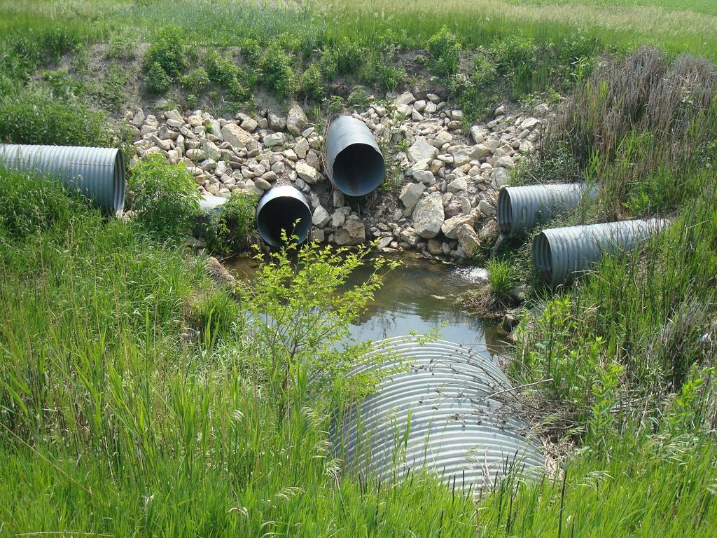
12 Iowa Land Cover


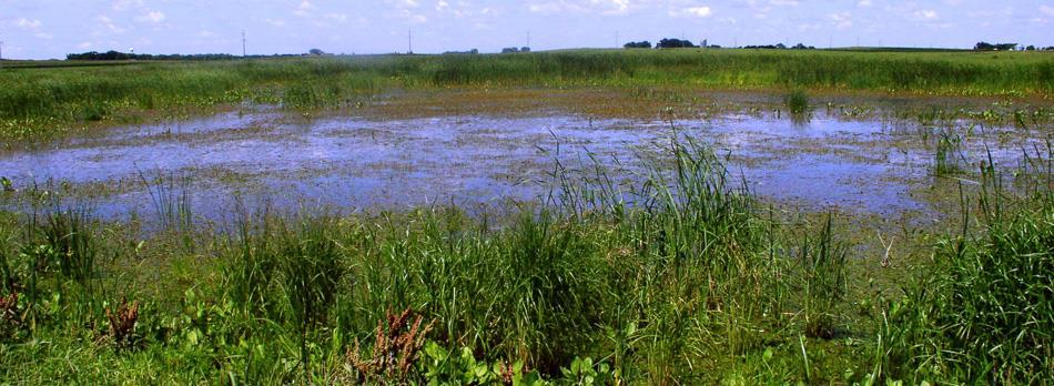
13 Pre-1850 Sandy or gravel bottom Gently-sloping banks with vegetation Perennial vegetation Wide, shallow streams Water table close to surface
14 Pre-1850 Surface runoff Seepage Groundwater exchange Infiltration
15
16


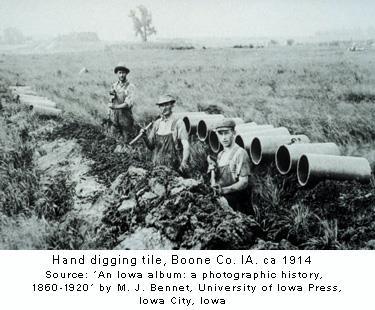
17 Now Tile drainage Annual vegetation Deep, narrow streams Steep, unvegetated banks Silt bottom Water table deeper
18 Now Surface runoff Tile drainage Seepage Infiltration Groundwater exchange
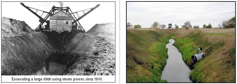
19 Incision


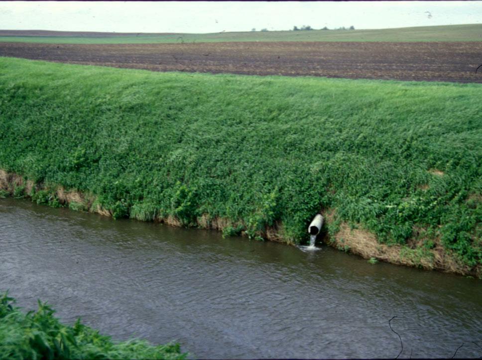
20 Where do streams begin? Tile outfalls! Slide courtesy of K. Schilling, Iowa Geological Survey


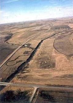
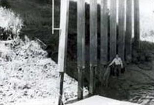
21 Downstrea m Walnut Creek Contribution of tiles to channel incision Channel depth at tile outlets = 1.4 m Channel depth at watershed outlet = 3.3 m 42% of channel incision may be sourced from tile drainage outfalls. Upstrea m Walnut Creek Slide courtesy of K. Schilling, Iowa Geological Survey

22 Drainage network developed on different age of glacial drift in Iowa Number of streams per unit area and drainage density increases with time Ruhe classic work (1952)

23 Extension of river drainage network from 1847 to 1972 Slide courtesy of K. Schilling, Iowa Geological Survey

24 Effects of tile drainage in Des Moines Lobe watershed Bear Creek Compared groundwater travel times various drained conditions: High Medium Low Perennial network Pre-settlement Slide courtesy of K. Schilling, Iowa Geological Survey Schilling et al., JEQ, 2015


25 Walnut Creek: Jasper County Slide courtesy of K. Schilling, Iowa Geological Survey
26 Extension of the drainage network Table 1. Comparison of morphological characteristics of Walnut Creek in 1847 and 1972 (after Anderson, 2000) Property GLO Survey (1847) 1972 USGS Streams Stream length (m) 37,185 60,286 Drainage density Channel frequency Total length of drainage system divided by watershed area 2 Total number of stream segments per unit area Slide courtesy of K. Schilling, Iowa Geological Survey Stream length nearly doubled Greater density and number of stream channels

27 It s Wetter: Increase over last century 16.2% 16.1% 8.1% 19.1% 8.4% 20.1% 7.1% 13.7% 5.8%

28 It s Wetter
29 Streams have more water Wapsipinicon Schilling, K. E. and Libra, R. D. (2003), INCREASED BASEFLOW IN IOWA OVER THE SECOND HALF OF THE 20TH CENTURY 1. JAWRA Journal of the American Water Resources Association, 39: doi: /j tb04410.x
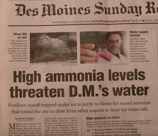
30 Streams have more water Wapsipinicon Schilling, K. E. and Libra, R. D. (2003), INCREASED BASEFLOW IN IOWA OVER THE SECOND HALF OF THE 20TH CENTURY 1. JAWRA Journal of the American Water Resources Association, 39: doi: /j tb04410.x
31 Streams have more water Wapsipinicon Baseflow=is the portion of streamflow that comes from "the sum of deep subsurface flow and delayed shallow subsurface flow". Schilling, K. E. and Libra, R. D. (2003), INCREASED BASEFLOW IN IOWA OVER THE SECOND HALF OF THE 20TH CENTURY 1. JAWRA Journal of the American Water Resources Association, 39: doi: /j tb04410.x
32 E. Nishnabotna Schilling, K. E. and Libra, R. D. (2003), INCREASED BASEFLOW IN IOWA OVER THE SECOND HALF OF THE 20TH CENTURY 1. JAWRA Journal of the American Water Resources Association, 39: doi: /j tb04410.x
33 Des Moines R. at Stratford
34 Iowa R. at Marengo
35 Extreme Precipitation 2-day precipitation event that is exceeded on average only once in five years.
36 Perry, Iowa 24-32% increase in annual precipitation o C increase in temperature Increase tile drainage flows Change distribution of flows within the calendar year
37

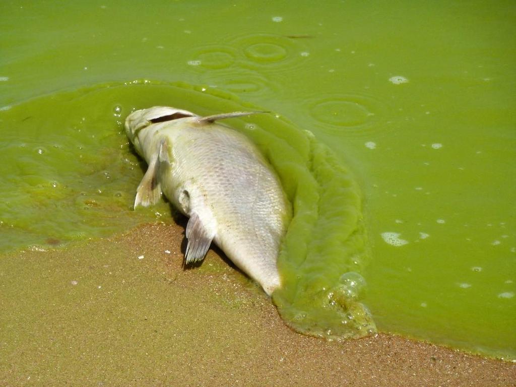
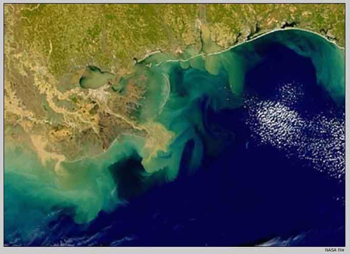
38 Hypoxia, Aquatic Life


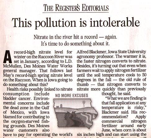
39 Drinking Tole Water Toledo, OH Des Moines, IA

40 Predicted average riverine nitrate N yield, January to June, for all counties in the Mississippi River basin for the period 1997 to David, et al., JEQ 39:
41 Ways of looking at data Average Concentration: mg/l Important for drinking water uses and aquatic life standards Annual values biased low by low flow summer months with low nitrate Annual values biased high by low flow winter months with high nitrate
42 Ways of looking at data Loads in tonnes, tons, pounds, kg Total mass of pollutant carried by the river over a defined period of time. Important for Gulf of Mexico Hypoxia, TMDL standards and industry performance Loads follow discharge, hard to track progress in face of climate variations
43 Flow-Weighted Average Ways of looking at data Total load/total discharge for the period of interest Helps buffer the highly variable effects of weather and discharge Good for trending
44
45
46 Raccoon River Trends: Flow Weighted Average Flow weighted average = total load/total flow
47 Des Moines River Flow Weighted Average
48 Loads LOADS (tonnes) Raccoon Des Moines N Yield (pounds per acre) >25% of inputs in 15 Raccoon Des Moines ave max 45 38
49 Loads driven by discharge Long term: N loss is TRANSPORT LIMITED

50 Loads driven by discharge Long term: N loss is TRANSPORT LIMITED
51 Transport vs Supply Limitations Transport River nitrate controlled by how much nitrate could be flushed from soil stores by hydrological processes operating in the watershed. Supply Nitrate availability in soil stores limits nitrate transfer to the stream

52 Raccoon River Sediment
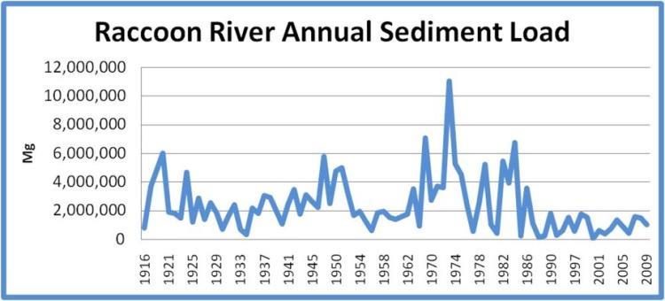
53
54 Sediment Load vs Discharge
55 Day of year matters
56 Supply Limitations vs Transport Limitations
57 In Iowa, we farm. 88,000 Farm Operations 30,500,000 Farmed Acres (12,700,000 Ha), 84% of the state s area. 13,050,000 acres of corn (2.5 billion bushels, value $8.8 billion) U.S. rank: 1 st 9,800,000 acres of soybean (554 million bushels, value $4.8 billion) U.S.A. ranking: 1 st 21 million hogs; U.S.A. ranking: 1 st 8.4 million turkeys; U.S.A. ranking: 9 th 52 million laying chickens; U.S.A. ranking: 1 st (15 billion eggs) 4 million cattle (including calves) U.S.A. ranking: 6 th 210,000 milk cows (4.8 billion pounds of milk) Sheep and Goat production: 6 th Oats: 7 th Hay: 11 th Corn for silage: 7 th


58

59


60
61

62 IIHR 2016 Real-Time Monitoring Network Iowa has 1/3 of all the continuous nitrate monitors in the U.S. About 80% of the water leaving the state will be monitored for nitrate in 2016.

63 Monitoring Network
64
65
66

67 Questions?
Overview of fluvial and geotechnical processes for TMDL assessment
 Overview of fluvial and geotechnical processes for TMDL assessment Christian F Lenhart, Assistant Prof, MSU Research Assoc., U of M Biosystems Engineering Fluvial processes in a glaciated landscape Martin
The Iowa Watershed Approach
 A vision for a more resilient Iowa Larry Weber Director, IIHR Hydroscience & Engineering Larry-weber@uiowa.edu 1 Kickoff Iowa Grant meeting Award: follow-up $96,887,177 2 How can we stay informed about
Modeling Upland and Channel Sources of Sediment in the Le Sueur River Watershed, Minnesota
 Modeling Upland and Channel Sources of Sediment in the Le Sueur River Watershed, Minnesota Solomon Folle and David Mulla Department of Soil, Water and Climate University of Minnesota August 6, 2009 5 th
Chris Lenhart, John Nieber, Ann Lewandowski, Jason Ulrich TOOLS AND STRATEGIES FOR REDUCING CHANNEL EROSION IN MINNESOTA
 Chris Lenhart, John Nieber, Ann Lewandowski, Jason Ulrich TOOLS AND STRATEGIES FOR REDUCING CHANNEL EROSION IN MINNESOTA Background and approach Channel loading major source of sediment in much of MN River
Introduction to the Hydrogeomorphic (HGM) Classification System
 Classification System") Introduction to the Hydrogeomorphic (HGM) Classification System Objectives The Student Will be Able to: Define the 7 HGM Classes List the 3 Parameters That Define HGM Classes List the Major Water Budget
Introduction to the Hydrogeomorphic (HGM) Classification System Objectives The Student Will be Able to: Define the 7 HGM Classes List the 3 Parameters That Define HGM Classes List the Major Water Budget
Appendix D. Model Setup, Calibration, and Validation
 . Model Setup, Calibration, and Validation Lower Grand River Watershed TMDL January 1 1. Model Selection and Setup The Loading Simulation Program in C++ (LSPC) was selected to address the modeling needs
Aquifer an underground zone or layer of sand, gravel, or porous rock that is saturated with water.
 Aggradation raising of the streambed by deposition that occurs when the energy of the water flowing through a stream reach is insufficient to transport sediment conveyed from upstream. Alluvium a general
In the space provided, write the letter of the description that best matches the term or phrase. a. any form of water that falls to Earth s
 Skills Worksheet Concept Review In the space provided, write the letter of the description that best matches the term or phrase. 1. condensation 2. floodplain 3. watershed 4. tributary 5. evapotranspiration
Section 5. Low-Gradient Streams. What Do You See? Think About It. Investigate. Learning Outcomes
 Chapter 4 Surface Processes Section 5 Low-Gradient Streams What Do You See? Learning Outcomes In this section, you will Use models and real-time streamflow data to understand the characteristics of lowgradient
Watershed concepts for community environmental planning
 Purpose and Objectives Watershed concepts for community environmental planning Dale Bruns, Wilkes University USDA Rural GIS Consortium May 2007 Provide background on basic concepts in watershed, stream,
3/3/2013. The hydro cycle water returns from the sea. All "toilet to tap." Introduction to Environmental Geology, 5e
 Introduction to Environmental Geology, 5e Running Water: summary in haiku form Edward A. Keller Chapter 9 Rivers and Flooding Lecture Presentation prepared by X. Mara Chen, Salisbury University The hydro
Surface Water and Stream Development
 Surface Water and Stream Development Surface Water The moment a raindrop falls to earth it begins its return to the sea. Once water reaches Earth s surface it may evaporate back into the atmosphere, soak
STUDY GUIDE FOR CONTENT MASTERY. Surface Water Movement
 Surface Water SECTION 9.1 Surface Water Movement In your textbook, read about surface water and the way in which it moves sediment. Complete each statement. 1. An excessive amount of water flowing downslope
Disentangling Impacts of Climate & Land Use Changes on the Quantity & Quality of River Flows in Southern Ontario
 Disentangling Impacts of Climate & Land Use Changes on the Quantity & Quality of River Flows in Southern Ontario by Trevor Dickinson & Ramesh Rudra, Water Resources Engineering University of Guelph Acknowledgements
REDWOOD VALLEY SUBAREA
 Independent Science Review Panel Conceptual Model of Watershed Hydrology, Surface Water and Groundwater Interactions and Stream Ecology for the Russian River Watershed Appendices A-1 APPENDIX A A-2 REDWOOD
How Do Human Impacts and Geomorphological Responses Vary with Spatial Scale in the Streams and Rivers of the Illinois Basin?
 How Do Human Impacts and Geomorphological Responses Vary with Spatial Scale in the Streams and Rivers of the Illinois Basin? Bruce Rhoads Department of Geography University of Illinois at Urbana-Champaign
Diagnostic Geomorphic Methods for Understanding Future Behavior of Lake Superior Streams What Have We Learned in Two Decades?
 Diagnostic Geomorphic Methods for Understanding Future Behavior of Lake Superior Streams What Have We Learned in Two Decades? Faith Fitzpatrick USGS WI Water Science Center, Middleton, WI fafitzpa@usgs.gov
Laboratory Exercise #3 The Hydrologic Cycle and Running Water Processes
 Laboratory Exercise #3 The Hydrologic Cycle and Running Water Processes page - 1 Section A - The Hydrologic Cycle Figure 1 illustrates the hydrologic cycle which quantifies how water is cycled throughout
WATER ON AND UNDER GROUND. Objectives. The Hydrologic Cycle
 WATER ON AND UNDER GROUND Objectives Define and describe the hydrologic cycle. Identify the basic characteristics of streams. Define drainage basin. Describe how floods occur and what factors may make
Rivers and Streams. Streams. Hydrologic Cycle. Drainage Basins and Divides. Colorado River Drainage Basin. Colorado Drainage Basins.
 Chapter 14 Hydrologic Cycle Rivers and Streams Streams A stream is a body of water that is confined in a channel and moves downhill under the influence of gravity. This definition includes all sizes of
Geog Lecture 19
 Geog 1000 - Lecture 19 Fluvial Geomorphology and River Systems http://scholar.ulethbridge.ca/chasmer/classes/ Today s Lecture (Pgs 346 355) 1. What is Fluvial Geomorphology? 2. Hydrology and the Water
Surface Processes Focus on Mass Wasting (Chapter 10)
") Surface Processes Focus on Mass Wasting (Chapter 10) 1. What is the distinction between weathering, mass wasting, and erosion? 2. What is the controlling force in mass wasting? What force provides resistance?
Surface Processes Focus on Mass Wasting (Chapter 10) 1. What is the distinction between weathering, mass wasting, and erosion? 2. What is the controlling force in mass wasting? What force provides resistance?
Which map shows the stream drainage pattern that most likely formed on the surface of this volcano? A) B)
 B)") 1. When snow cover on the land melts, the water will most likely become surface runoff if the land surface is A) frozen B) porous C) grass covered D) unconsolidated gravel Base your answers to questions
1. When snow cover on the land melts, the water will most likely become surface runoff if the land surface is A) frozen B) porous C) grass covered D) unconsolidated gravel Base your answers to questions
low turbidity high turbidity
 What is Turbidity? Turbidity refers to how clear the water is. The greater the amount of total suspended solids (TSS) in the water, the murkier it appears and the higher the measured turbidity. Excessive
STREAM SYSTEMS and FLOODS
 STREAM SYSTEMS and FLOODS The Hydrologic Cycle Precipitation Evaporation Infiltration Runoff Transpiration Earth s Water and the Hydrologic Cycle The Hydrologic Cycle The Hydrologic Cycle Oceans not filling
Precipitation Evaporation Infiltration Earth s Water and the Hydrologic Cycle. Runoff Transpiration
 STREAM SYSTEMS and FLOODS The Hydrologic Cycle Precipitation Evaporation Infiltration Earth s Water and the Hydrologic Cycle Runoff Transpiration The Hydrologic Cycle The Hydrologic Cycle Oceans not filling
Forest Hydrology: Lect. 9. Contents. Runoff, soil water and infiltration
 Forest Hydrology: Lect. 9 Contents Runoff, soil water and infiltration Learning objectives:. - Hillslope runoff generation processes; - Dynamics of runoff generation processes; - Hortonian and Dunnian
12 SWAT USER S MANUAL, VERSION 98.1
 12 SWAT USER S MANUAL, VERSION 98.1 CANOPY STORAGE. Canopy storage is the water intercepted by vegetative surfaces (the canopy) where it is held and made available for evaporation. When using the curve
RR#5 - Free Response
 Base your answers to questions 1 through 3 on the data table below and on your knowledge of Earth Science. The table shows the area, in million square kilometers, of the Arctic Ocean covered by ice from
Description DESCRIPTION
 DESCRIPTION The location of the Upper James Watershed is located in northeastern South Dakota as well as southeastern North Dakota. It includes the following counties located in North Dakota Barnes, Dickey,
Stream Geomorphology. Leslie A. Morrissey UVM July 25, 2012
 Stream Geomorphology Leslie A. Morrissey UVM July 25, 2012 What Functions do Healthy Streams Provide? Flood mitigation Water supply Water quality Sediment storage and transport Habitat Recreation Transportation
Running Water Earth - Chapter 16 Stan Hatfield Southwestern Illinois College
 Running Water Earth - Chapter 16 Stan Hatfield Southwestern Illinois College Hydrologic Cycle The hydrologic cycle is a summary of the circulation of Earth s water supply. Processes involved in the hydrologic
Science of Natural Disasters: RIVERS& FLOODS! 27 April 2016
 Science of Natural Disasters: RIVERS& FLOODS! 27 April 2016 Rebecca Clotts Department of Geology, University of St Thomas Flood in St Paul, 2014, Star Tribune 1 2 What is a watershed? 3 4 5 6 7 What is
Groundwater-Surface Water Interactions along the Hangman, California, and Rock Creeks, September 30, 2009
 Groundwater-Surface Water Interactions along the Hangman, California, and Rock Creeks, September 30, 2009 Abstract This data collection effort was required to complete recommendations in the Hangman Creek
NREM 407/507 - March 26. International Rivers Project. 1. Yellow River Presentation today Nile River next Tuesday
 NREM 407/507 - March 26 1. Yellow River Presentation today Nile River next Tuesday 2. Calculate stream bank erosion, gully erosion and sheet and rill erosion for the Swenson Farm that we visited on Tuesday
Erosion Surface Water. moving, transporting, and depositing sediment.
 + Erosion Surface Water moving, transporting, and depositing sediment. + Surface Water 2 Water from rainfall can hit Earth s surface and do a number of things: Slowly soak into the ground: Infiltration
mountain rivers fixed channel boundaries (bedrock banks and bed) high transport capacity low storage input output
 high transport capacity low storage input output") mountain rivers fixed channel boundaries (bedrock banks and bed) high transport capacity low storage input output strong interaction between streams & hillslopes Sediment Budgets for Mountain Rivers Little
mountain rivers fixed channel boundaries (bedrock banks and bed) high transport capacity low storage input output strong interaction between streams & hillslopes Sediment Budgets for Mountain Rivers Little
Upper Truckee River Restoration Lake Tahoe, California Presented by Brendan Belby Sacramento, California
 Upper Truckee River Restoration Lake Tahoe, California Presented by Brendan Belby Sacramento, California Mike Rudd (Project Manager), Charley Miller & Chad Krofta Declines in Tahoe s Water Clarity The
Influence of the Major Drainages to the Mississippi River and Implications for System Level Management
 Influence of the Major Drainages to the Mississippi River and Implications for System Level Management Brian M. Vosburg Geologist Louisiana Coastal Protection and Restoration Authority brian.vosburg@la.gov
Patrick Baskfield. Scott Matteson. Minnesota Pollution Control Agency. Minnesota State University Water Resource Center
 Regression Analysis of Total Suspended Solids Concentrations to Estimate Streambank, Upland Field, and Classic Gully Sediment Contributions to Minnesota River Tributaries Patrick Baskfield Minnesota Pollution
Sediment Deposition LET THE RIVER RUN T E A C H E R. Activity Overview. Activity at a Glance. Time Required. Level of Complexity.
 Activity at a Glance Grade: 6 9 Subject: Science Category: Physical Science, Earth Science Topic: Deposition, River Systems Time Required Two 45-minute periods Level of Complexity Medium Materials* TI-73
Exploring the role of channel processes and legacy sediment in nutrient and sediment delivery, Upper Pecatonica River, Wisconsin
 Exploring the role of channel processes and legacy sediment in nutrient and sediment delivery, Upper Pecatonica River, Wisconsin Faith Fitzpatrick and Rebecca Carvin (USGS WI Water Science Center), Robert
Chapter 2. Regional Landscapes and the Hydrologic Cycle
 Chapter 2. Regional Landscapes and the Hydrologic Cycle W. Lee Daniels Department of Crop and Soil Environmental Sciences, Virginia Tech Table of Contents Introduction... 23 Soils and landscapes of the
Use of SWAT to Scale Sediment Delivery from Field to Watershed in an Agricultural Landscape with Depressions
 Use of SWAT to Scale Sediment Delivery from Field to Watershed in an Agricultural Landscape with Depressions James E. Almendinger St. Croix Watershed Research Station, Science Museum of Minnesota Marylee
Each basin is surrounded & defined by a drainage divide (high point from which water flows away) Channel initiation
 Channel initiation") DRAINAGE BASINS A drainage basin or watershed is defined from a downstream point, working upstream, to include all of the hillslope & channel areas which drain to that point Each basin is surrounded &
DRAINAGE BASINS A drainage basin or watershed is defined from a downstream point, working upstream, to include all of the hillslope & channel areas which drain to that point Each basin is surrounded &
Running Water: The Geology of Streams and Floods Running Water Chapter 14
 Geology 800 Today Running Water: The Geology of Streams and Floods Running Water Chapter 14 Next Class Oceans and Coasts 15 Stream Flow Streams Ribbons of water that flow down channels. Runoff Water in
Science EOG Review: Landforms
 Mathematician Science EOG Review: Landforms Vocabulary Definition Term canyon deep, large, V- shaped valley formed by a river over millions of years of erosion; sometimes called gorges (example: Linville
Gully Erosion Part 1 GULLY EROSION AND ITS CAUSES. Introduction. The mechanics of gully erosion
 Gully Erosion Part 1 GULLY EROSION AND ITS CAUSES Gully erosion A complex of processes whereby the removal of soil is characterised by incised channels in the landscape. NSW Soil Conservation Service,
What do you need for a Marathon?
 What do you need for a Marathon? Water and a snack? What about just a normal day? 1 flush = 3.5 gallons 1 flush = 3.5 gallons 10 minute shower = 20 gal 1 flush = 3.5 gallons 10 minute shower = 20 gal Jeans
ENGINEERING EXPERIMENT STATION IOWA STATE UNIVERSITY, AMES, IOWA. by FIORE J L I, MORPHOMETRIC COMPARISON OF
 STECHNICAL REPORT 1 MORPHOMETRIC COMPARISON OF HAYDEN PRAIRIE AND ADJACENT CULTIVATED AREA by FIORE 902@6 Keith W. Anderson, Graduate Assistant R. A. Lohnes, Assistant Professor of Civil Engineering (Distribution
RIVERS, GROUNDWATER, AND GLACIERS
 RIVERS, GROUNDWATER, AND GLACIERS Delta A fan-shaped deposit that forms when a river flows into a quiet or large body of water, such as a lake, an ocean, or an inland sea. Alluvial Fan A sloping triangle
UGRC 144 Science and Technology in Our Lives/Geohazards
 UGRC 144 Science and Technology in Our Lives/Geohazards Flood and Flood Hazards Dr. Patrick Asamoah Sakyi Department of Earth Science, UG, Legon College of Education School of Continuing and Distance Education
Streams. Water. Hydrologic Cycle. Geol 104: Streams
 Streams Why study streams? Running water is the most important geologic agent in erosion, transportation and deposition of sediments. Water The unique physical and chemical properties of water make it
River/Stream Erosion Notes
 Name Date ES per Mr. Williams River/Stream Erosion Notes Erosion: the of weathered material. FACT: Running water moves more sediment than ANY other type of erosion. 1. The Water Cycle What happens when
Challenges in Calibrating a Large Watershed Model with Varying Hydrogeologic Conditions
 Challenges in Calibrating a Large Watershed Model with Varying Hydrogeologic Conditions Presented by Johnathan R. Bumgarner, P.G., Celine A.L. Louwers, & Monica P. Suarez, P.E. In cooperation with the
Bank Erosion and Morphology of the Kaskaskia River
 Bank Erosion and Morphology of the Kaskaskia River US Army Corps Of Engineers St. Louis District Fayette County Soil and Water Conservation District Team Partners : Carlyle Lake Ecosystem Partnership Vicinity
Freshwater. 1. The diagram below is a cross-sectional view of rain falling on a farm field and then moving to the water table.
 Name: ate: 1. The diagram below is a cross-sectional view of rain falling on a farm field and then moving to the water table. 3. Which conditions produce the most surface water runoff? A. steep slope,
The River Restoration Centre therrc.co.uk. Understanding Fluvial Processes: supporting River Restoration. Dr Jenny Mant
 The River Restoration Centre therrc.co.uk Understanding Fluvial Processes: supporting River Restoration Dr Jenny Mant Jenny@therrc.co.uk Understanding your catchment Hydrology Energy associated with the
Summary. Streams and Drainage Systems
 Streams and Drainage Systems Summary Streams are part of the hydrologic cycle and the chief means by which water returns from the land to the sea. They help shape the Earth s surface and transport sediment
Floods Lecture #21 20
 Floods 20 Lecture #21 What Is a Flood? Def: high discharge event along a river! Due to heavy rain or snow-melt During a flood, a river:! Erodes channel o Deeper & wider! Overflows channel o Deposits sediment
Big Wood River. General Information
 General Information The flows out of the southern portion of the Sawtooth National Recreation Area in central Idaho. The study reach is about a,200 ft length of river about.5 miles upstream from the discontinued
Executive Summary. Water Quantity
 Executive Summary Stakeholders in the Rock-Glade Watershed have taken the initiative to proceed with watershed planning as provided by the State of Washington under the Watershed Management Act (Chapter
the path to studying tile drainage
 Fingerprinting Sources of Suspended Sediments Mean 210 Pb Flux (pci/cm 2 /yr) 2.5 2 1.5 1 0.5 Sagatagan Kreighle Henderson George Long Diamond Duck Stahl Reference Lakes y = 0.65 + 4.8x R 2 = 0.58 Hook
HW #2 Landscape Travel from A to B 12,
 HW #2 Landscape 2016 Section: Name: ate: 1. ase your answer(s) to the following question(s) on the map below, which represents two bridges that cross the Green River. Letters,, and represent locations
Fluvial Systems Lab Environmental Geology Lab Dr. Johnson
 Fluvial Systems Lab Environmental Geology Lab Dr. Johnson *Introductory sections of this lab were adapted from Pidwirny, M. (2006). "Streamflow and Fluvial Processes". Fundamentals of Physical Geography,
A SURVEY OF HYDROCLIMATE, FLOODING, AND RUNOFF IN THE RED RIVER BASIN PRIOR TO 1870
 A SURVEY OF HYDROCLIMATE, FLOODING, AND RUNOFF IN THE RED RIVER BASIN PRIOR TO 1870 W. F. RANNIE (UNIVERSITY OF WINNIPEG) Prepared for the Geological Survey of Canada September, 1998 TABLE OF CONTENTS
Michigan s Geology and Groundwater
 Michigan s Geology and Groundwater Ralph J. Haefner Deputy Director U.S. Geological Survey Michigan-Ohio Water Science Center Lansing, Michigan Outline About the USGS Geology 101 Michigan s geology Bedrock
Continuing Education Associated with Maintaining CPESC and CESSWI Certification
 Continuing Education Associated with Maintaining CPESC and CESSWI Certification Module 2: Stormwater Management Principles for Earth Disturbing Activities Sponsors: ODOTs Local Technical Assistance Program
Napa County Comprehensive Groundwater Monitoring Program 2015 Annual Report and CASGEM Update
 Napa County Comprehensive Groundwater Monitoring Program 2015 Annual Report and CASGEM Update April 21, 2016 Watershed Information & Conservation Council By Vicki Kretsinger Grabert Overview Evolving groundwater
to low order streams, or percolated down to the water table (Yang et al., 2009). The prevalence of
. The prevalence of") Introduction The Effect of Land-cover Changes on Lag Time in the Banklick Creek Watershed, KY Katelyn Toebbe University of Louisville Department of Geography and Geosciences Urbanization in a watershed
Introduction The Effect of Land-cover Changes on Lag Time in the Banklick Creek Watershed, KY Katelyn Toebbe University of Louisville Department of Geography and Geosciences Urbanization in a watershed
What Is Water Erosion? Aren t they the same thing? What Is Sediment? What Is Sedimentation? How can Sediment Yields be Minimized?
 Jerald S. Fifield, Ph.D. CISEC HydroDynamics Incorporated Parker, CO 303-841-0377 Aren t they the same thing? What Is Sediment? Soil particles deposited or suspended in water or air The process of depositing
ENGINEERING HYDROLOGY
 ENGINEERING HYDROLOGY Prof. Rajesh Bhagat Asst. Professor Civil Engineering Department Yeshwantrao Chavan College Of Engineering Nagpur B. E. (Civil Engg.) M. Tech. (Enviro. Engg.) GCOE, Amravati VNIT,
Waterways from glaciers to coastal waters in Iceland. Jórunn Harðardóttir, IMO Nordic WFD conference September 26, 2012
 Waterways from glaciers to coastal waters in Iceland Jórunn Harðardóttir, IMO Nordic WFD conference September 26, 2012 What to include and what not to include? Hydrology of Iceland Much on glaciers and
Chapter 3. Description of the Study Area. Karl Taboga, James Stafford and Paul Taucher 3-19
 Chapter 3 Description of the Study Area Karl Taboga, James Stafford and Paul Taucher 3-19 T his study examines groundwater resources that underlie the Bear River drainage basin in Wyoming as well as areas
Working with Natural Stream Systems
 Working with Natural Stream Systems Graydon Dutcher Delaware County Soil & Water Conservation District Stream Corridor Management Program Tropical Storm Sandy October 29,2012 What is a Watershed?
Geography Notes for Plonk Meeting
 Geography Notes for Plonk Meeting Hydrologic Cycle 1. Rainfall Water falls as rain or snow if the air is cold enough. 2. Groundwater Water that seeps into the ground may be absorbed by plants or flow into
MICHIGAN GEOLOGICAL SURVEY Coastal Navigator Training St. Joseph, Michigan What do we know about anthropogenic impact(s) to Lake Michigan shorelines?
 to Lake Michigan shorelines?") MICHIGAN GEOLOGICAL SURVEY Coastal Navigator Training St. Joseph, Michigan What do we know about anthropogenic impact(s) to Lake Michigan shorelines? Review of a 12 year shoreline study and today, what
MICHIGAN GEOLOGICAL SURVEY Coastal Navigator Training St. Joseph, Michigan What do we know about anthropogenic impact(s) to Lake Michigan shorelines? Review of a 12 year shoreline study and today, what
Rivers T. Perron
 1 Rivers T. Perron 12.001 After our discussions of large-scale topography, how we represent topography in maps, and how topography interacts with geologic structures, you should be frothing at the mouth
 12 10 8 6 4 2 0 40-50 50-60 60-70 70-80 80-90 90-100 Fresh Water What we will cover The Hydrologic Cycle River systems Floods Groundwater Caves and Karst Topography Hot springs Distribution of water in
Chapter 3 Erosion and Deposition. The Big Question:
 Chapter 3 Erosion and Deposition The Big Question: 1 Design a way to represent and describe the 4 types of mass movement. You may use pictures, diagrams, list, web, chart, etc 2 Chapter 3: Erosion and
River Response. Sediment Water Wood. Confinement. Bank material. Channel morphology. Valley slope. Riparian vegetation.
 River Response River Response Sediment Water Wood Confinement Valley slope Channel morphology Bank material Flow obstructions Riparian vegetation climate catchment vegetation hydrological regime channel
Monitoring of suspended sediment concentration in discharge from regulated lakes in glacial deposits
 Erosion and Sediment Transport Monitoring Programmes in River Basins (Proceedings of the Oslo Symposium, August 1992). IAHS Publ. no. 210, 1992. 269 Monitoring of suspended sediment concentration in discharge
Illinois State Water Survey Division
 Illinois State Water Survey Division SURFACE WATER SECTION SWS Miscellaneous Publication 108 SEDIMENT YIELD AND ACCUMULATION IN THE LOWER CACHE RIVER by Misganaw Demissie Champaign, Illinois June 1989
For Sale at $437,500.00
 We are pleased to present Carlson Farm 72.43 ± Acres Garden City Township, Blue Earth County For Sale at $437,500.00 Listing Agent: Darrell Hylen, ALC Office: 507-345-LAND (5263) Toll Free: 800-730-LAND
6.1 Water. The Water Cycle
 6.1 Water The Water Cycle Water constantly moves among the oceans, the atmosphere, the solid Earth, and the biosphere. This unending circulation of Earth s water supply is the water cycle. The Water Cycle
Prentice Hall EARTH SCIENCE
 Prentice Hall EARTH SCIENCE Tarbuck Lutgens Running Water and Groundwater Running Water The Water Cycle Water constantly moves among the oceans, the atmosphere, the solid Earth, and the biosphere. This
Watershed Conservation Management Planning Using the Integrated Field & Channel Technology of AnnAGNPS & CONCEPTS
 Watershed Conservation Management Planning Using the Integrated Field & Channel Technology of AnnAGNPS & CONCEPTS Eddy Langendoen Ron Bingner USDA-ARS National Sedimentation Laboratory, Oxford, Mississippi
Mark S. Nordberg Geology and Groundwater Investigations Section North Central Region Office California Department of Water Resources
 Mark S. Nordberg Geology and Groundwater Investigations Section North Central Region Office California Department of Water Resources Ukiah Drought Workshop July 29, 2009 Groundwater 101 Groundwater is
Objectives: After completing this assignment, you should be able to:
 Data Analysis Assignment #1 Evaluating the effects of watershed land use on storm runoff Assignment due: 21 February 2013, 5 pm Objectives: After completing this assignment, you should be able to: 1) Calculate
Landscape Development
 Landscape Development Slopes Dominate Natural Landscapes Created by the interplay of tectonic and igneous activity and gradation Deformation and uplift Volcanic activity Agents of gradation Mass wasting
Bell Ringer. Are soil and dirt the same material? In your explanation be sure to talk about plants.
 Bell Ringer Are soil and dirt the same material? In your explanation be sure to talk about plants. 5.3 Mass Movements Triggers of Mass Movements The transfer of rock and soil downslope due to gravity is
Napa Valley Groundwater Sustainability: A Basin Analysis Report for the Napa Valley Subbasin
 Napa Valley Groundwater Sustainability: A Basin Analysis Report for the Napa Valley Subbasin December 13, 2016 Napa County Board of Supervisors By Vicki Kretsinger Grabert and Reid Bryson Basin Analysis
Delaware County Census Data
 Number of s Owners Percent of s Operated by Owner Percent of Tenancy Number of Renters Number of Managers No Return 94 90 96 4 4 0 0 42 35 83 17 6 1 1 62 56 90 10 6 0 4 19 11 58 42 4 4 0 137 114 83 17
Riparian Assessment. Steps in the right direction... Drainage Basin/Watershed: Start by Thinking Big. Riparian Assessment vs.
 Riparian Assessment vs. Monitoring Riparian Assessment What is a healthy stream? Determine stream/riparian health Determine change or trend, especially in response to mgmt Classification = designation
Modeling Post-Development Runoff and Channel Impacts from Hydromodification: Practical Tools for Hydromodification Assessment
 Modeling Post-Development Runoff and Channel Impacts from Hydromodification: Practical Tools for Hydromodification Assessment Chris Bowles, Ph.D. Andy Collison, Ph.D. Matt Wickland, M.S. c.bowles@pwa-ltd.com
High-Gradient Streams
 Chapter 4 Surface Processes Section 4 High-Gradient Streams What Do You See? Learning Outcomes In this section, you will Use models and real-time streamflow data to understand the characteristics of highgradient
Chapter 10. Running Water aka Rivers. BFRB Pages
 Chapter 10 Running Water aka Rivers BFRB Pages 101-116 Stream Erosion and Transportation Running water is all precipitation (rain, snow, etc) that falls on Earth and is pulled downhill by gravity. Running
Monitoring Headwater Streams for Landscape Response to
 Monitoring Headwater Streams for Landscape Response to Climate Change Matthew Connor, PhD Connor nvironmental, nc. www.oe-i.com icom Healdsburg, California verview Headwater stream geomorphology Response
Name: KEY OBJECTIVES HYDROLOGY:
 Name: KEY OBJECTIVES Correctly define: abrasion, capillarity, deposition, discharge, erosion, evapotranspiration, hydrology, impermeable, infiltration, meander, permeable, porosity, water table, weathering,
Year 6. Geography. Revision
 Year 6 Geography Revision November 2017 Rivers and World knowledge How the water cycle works and the meaning of the terms evaporation, condensation, precipitation, transpiration, surface run-off, groundwater