Shasta Valley Groundwater Basin Boundary Modification
|
|
|
- Irene Hopkins
- 5 years ago
- Views:
Transcription

1 Shasta Valley Groundwater Basin Boundary Modification
2 Sustainable Groundwater Management Act (SGMA) September 2014 Governor Brown signs legislation requiring groundwater resources be managed by local agencies Governor emphasized groundwater mgmt best accomplished locally SGMA establishes requirements for how groundwater basins will be managed over the long-term through Groundwater Sustainability Agencies and Groundwater Sustainability Plans (GSP) Requires agencies of high & medium priority basins to halt overdraft & bring groundwater basins into balance
3 Groundwater Sustainability Plan (GSP) 6 Undesirable Results that must be assessed & managed through minimum thresholds Groundwater storage reduction Chronic lowering of groundwater levels Water quality degradation Interconnected surface water depletion Land subsidence Seawater intrusion
4 Groundwater Sustainability Plan (GSP) Multiple requirements must be implemented into the GSP based on DWR determined BMP s Hydrogeologic Conceptual Model Groundwater model Water budget and balance Establish minimum thresholds & measureable objectives for 6 sustainability factors Management areas Planning & Implementation horizon
5 Groundwater Sustainability Plan (GSP) Monitoring Network wells, surface flows, water quality, subsidence, data collection & storage Recharge, banking, conjunctive use opportunities Achieve sustainability no later than 2042 May, but not required to address undesirable results prior to 1/1/15 Developed from consulting assistance through RFP process
6 SGMA & Residential Use de minimis extractor means a person who extracts, for domestic purposes, two acre-feet or less per year. SGMA definition Measuring devices & reporting does not apply A GSA shall not impose a fee pursuant to this subdivision on a de minimis extractor unless the agency has regulated the users pursuant to this part
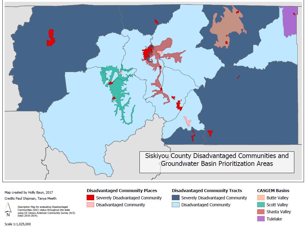
7 Disadvantaged Communities
8 Potential Results from boundary change Inclusion in locally controlled plan, built on local knowledge, studies, & input Reliable water availability knowledge & planning based on GSP Recharge benefits within basin boundary Legislation language Project & funding opportunities Grant & GSP related projects can only apply within the basin boundary Seat at table & input to GSA & GSP development A process is in place to determine overdraft regions or negative groundwater supplies, & develop strategy to improve
9 Potential Results from boundary change More regulation & oversight Potential for additional fees, costs, etc Public process Worst case scenarios around California - potential restrictions, shut-offs, or capping Not expected in Siskiyou County Potential data & access intrusion Does not modify, determine or authorize surface water or groundwater rights

10 Current boundary
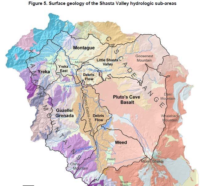
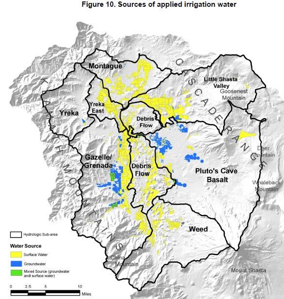
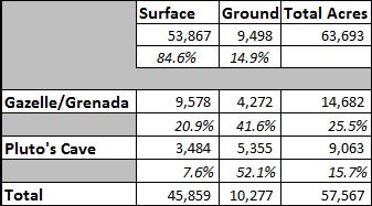
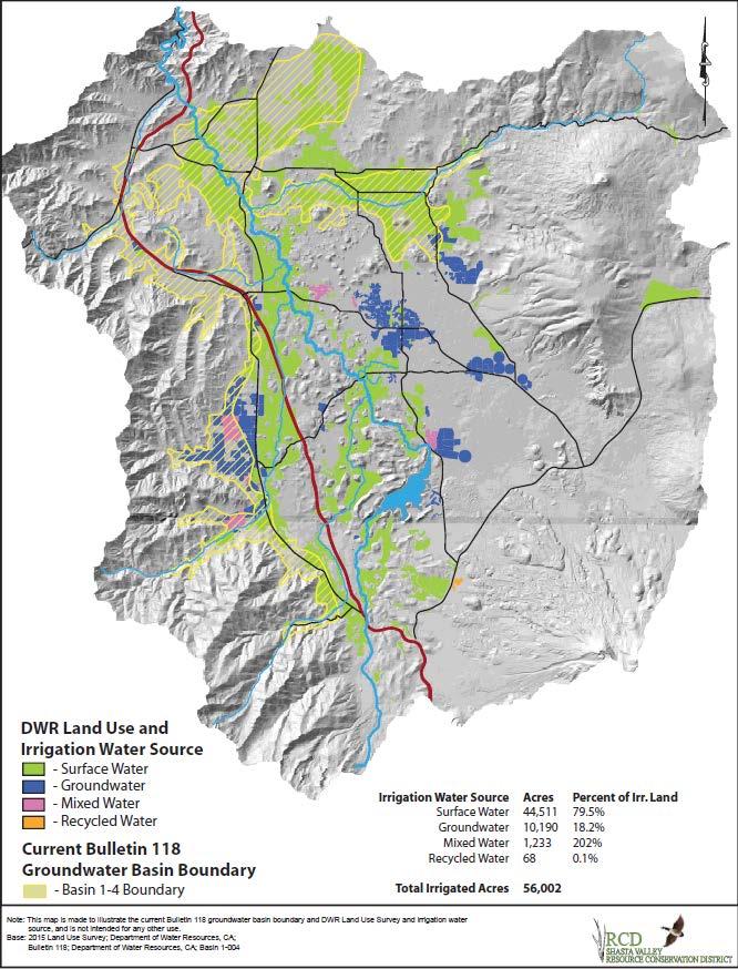
11 Proposed boundary Pluto s cave region provides abundant groundwater Shasta River connection Over 52% of groundwater irrigation use Encompasses large use area Covers remaining water use in Gazelle/Grenada subregion

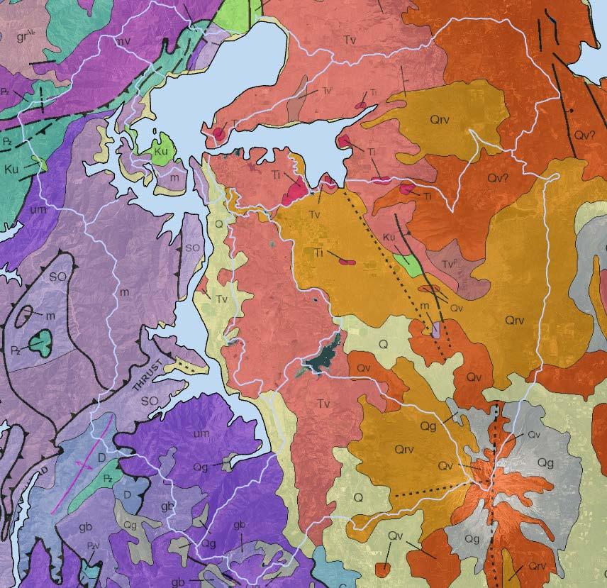
12 Bulletin 118 (2003)
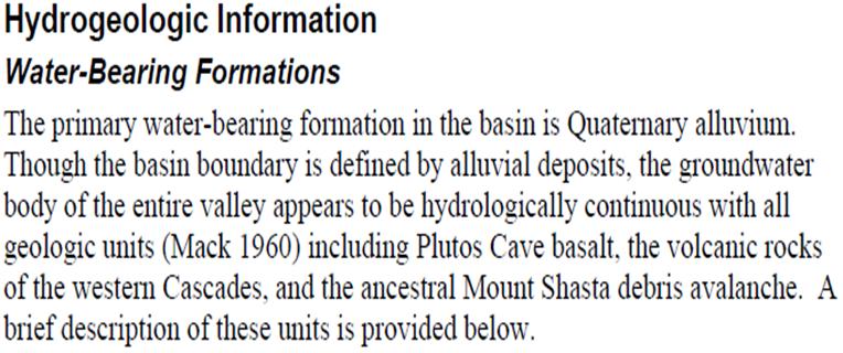
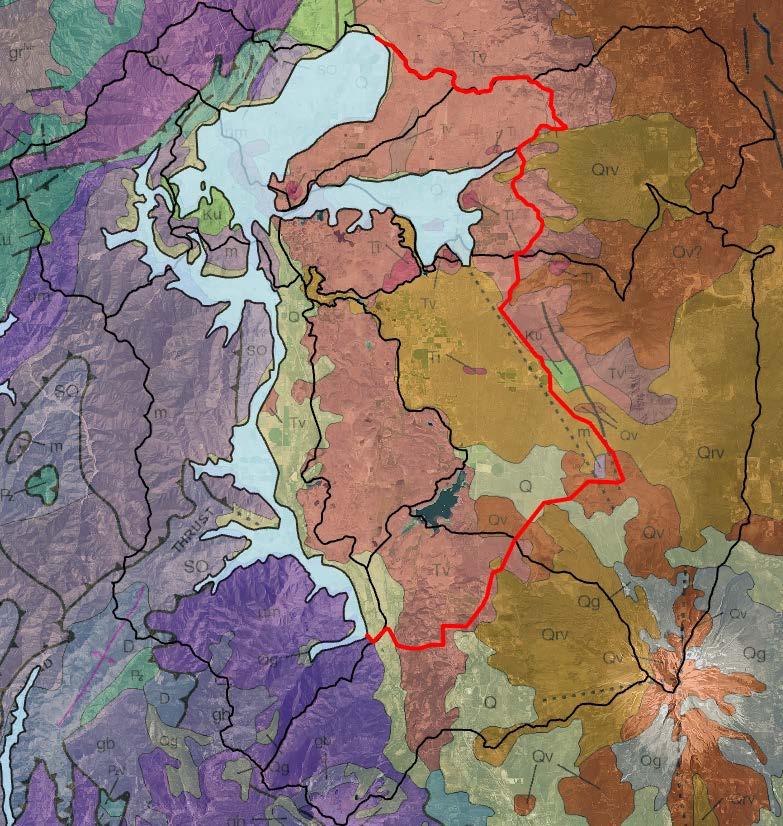
13 Justification for revising the boundary g-water body of valley appears to be hydrologically continuous with all geologic units (Mack 1960), including Plutos Cave basalt, volcanic rocks of the western Cascades, & Debris Flow Bulletin 118 (2004) Basalt is highly vesicular & fractured, contains lava tubes, and transmits large volumes of g-water Ward (2011)
14 Justification for revising the boundary Probably the greatest significance of the volcanic debris avalanche is the role it plays in regulating and redirecting the natural flow of groundwater to the Shasta River. The avalanche deposits resulted in a barrier to the subsequent flow and deposition of the Pluto s Cave basalt. The juxtaposition of the less permeable avalanche deposits with the more permeable Pluto s Cave basalt impedes the flow of groundwater from the basalt, giving rise to numerous springs (including Big Springs) along the line of contact between the formations. (Ward, 2011)
15 Supporting Technical Reports Geology & Groundwater Features of Shasta Valley, Siskiyou County California Mack (1960) Shasta Valley, Siskiyou County Groundwater Data Needs Assessment DWR/Ward (2011) Managing Groundwater for Environmental Stream Temperature Buck (2013) Shasta Valley Groundwater Basin Bulletin 118 (2004) Template for components that would be desirable in order to prepare a groundwater management plan for the Shasta Valley Siskiyou County, California Davids Engineering, Inc. (2012)

16

17
18

19 Spring depth change

20 Fall depth change

21 Proposed boundary

22 Proposed boundary DWR Production Well Count per Township Range and Section

23 Proposed boundary DWR Domestic Well Count per Township Range and Section

24 Proposed boundary
25 Process to submit Proposed Basin Boundary Modification Public outreach & accompanying documentation On-going Provide comment & subsequent recommendation to the GSA board of directors Flood Control directed continued research Information gathering & boundary line development - Currently Public meetings regarding proposed draft line 5/31 Groundwater advisory committee recommendation - June Notify DWR by writing, of intent to modify - June GSA decision & approving resolution - June Submit application
26 Timeline for Boundary Adoption Notification of Intent to DWR Public outreach workshop May 31 Public Hearing June 12th Resolution approving GSA to submit application June 12th Finalize application June 13 th to 30 th Submit Application June 30 (or when ready) 30-day public comment June 30-July 30 Draft release Fall 2018? Final modifications release Fall/Winter 2018 Basin adopted under Bulletin ?
27 Public comment GSA welcomes all comments from public Letters/ of support or opposition Send to: Subject Shasta Groundwater Basin Boundary Public Hearing Official comment during DWR review period (6/30-7/30)
Merced Groundwater Sustainability Plan. Public Meeting August 2, 2018
 Merced Groundwater Sustainability Plan Public Meeting August 2, 2018 Agenda Welcome and Introductions Sustainable Groundwater Management Act Purpose and Requirements Groundwater Sustainability Plan Timeline
Sustainable Groundwater Management Act: Initial Notification of a Proposed Basin Boundary Modification
 Sustainable Groundwater Management Act: Initial Notification of a Proposed Basin Boundary Modification Proposed Boundary Modification The Butte County Department of Water and Resource Conservation has
Delta-Mendota Groundwater Subbasin
 Delta-Mendota Groundwater Subbasin SGMA Frequently Asked Questions Sustainable Groundwater Management Act What is the Sustainable Groundwater Management Act? The Sustainable Groundwater Management Act,
Napa Valley Groundwater Sustainability: A Basin Analysis Report for the Napa Valley Subbasin
 Napa Valley Groundwater Sustainability: A Basin Analysis Report for the Napa Valley Subbasin A report prepared pursuant to California Water Code Section 10733.6(b)(3) EXECUTIVE SUMMARY (354.4(A)) 1 1.0
Santa Clara Valley Water District Page 1 of 4
 Santa Clara Valley Water District File No.: 16-0304 Agenda Date: 5/24/2016 Item No.: 2.7. BOARD AGENDA MEMORANDUM SUBJECT: Public Hearing and Resolution on the Decision to Become the Groundwater Sustainability
Tule Subbasin: Sustainable Groundwater Management Act (SGMA) August 24, 2016 David De Groot, Professional Engineer 4Creeks, Inc.
 August 24, 2016 David De Groot, Professional Engineer 4Creeks, Inc.") Tule Subbasin: Sustainable Groundwater Management Act (SGMA) August 24, 2016 David De Groot, Professional Engineer 4Creeks, Inc. Overview 1 SUSTAINABLE GROUNDWATER MANAGEMENT ACT 2 TECHNICAL OVERVIEW OF
Tule Subbasin: Sustainable Groundwater Management Act (SGMA) August 24, 2016 David De Groot, Professional Engineer 4Creeks, Inc. Overview 1 SUSTAINABLE GROUNDWATER MANAGEMENT ACT 2 TECHNICAL OVERVIEW OF
COUNTY OF GLENN BOARD REPORT. Submitted by Department of Agriculture
 COUNTY OF GLENN BOARD REPORT Submitted by Department of Agriculture EXECUTIVE SUMMARY: There are three subbasins in Glenn County required to be managed under the Sustainable Groundwater Management Act
WHITE WOLF GSA ACCOMPLISHMENTS AND SHORT-TERM SGMA COMPLIANCE GOALS
 WHITE WOLF GSA ACCOMPLISHMENTS AND SHORT-TERM SGMA COMPLIANCE GOALS 22 AUGUST 2017 OUTLINE SGMA Compliance Timeline Accomplishments to Date SGMA Road Map for the White Wolf Subbasin 2042 2022 2017 2016
Stanislaus County Water Advisory Committee. May 30, 2018
 Stanislaus County Water Advisory Committee May 30, 2018 2018 Hydrologic Conditions and Water Supply Outlook 2018 Water Allocations WEST Federal 45% State 35% CCID 100% EAST SSJID 100% OID
Butte County Board of Supervisors Agenda Transmittal
 Butte County Board of Supervisors Agenda Transmittal Clerk of the Board Use Only Agenda Item: 3.38 Subject: Resolution to Establish the Butte County Groundwater Sustainability Agency in the West Butte
DRAFT. REVISED Draft. Paso Robles Subbasin Groundwater Sustainability Plan Chapter 6
 REVISED Draft Paso Robles Subbasin Groundwater Sustainability Plan Chapter 6 Prepared for the Paso Robles Subbasin Cooperative Committee and the Groundwater Sustainability Agencies February 14, 2019 Paso
COUNTY OF SACRAMENTO CALIFO IA
 APP,,tovED MAIO OF SVIDERVISORS 1 ivo, W0,7-02 0 A 11 2017 Lit/ficfr ' By Clerk of the Board COUNTY OF SACRAMENTO CALIFO IA 71 For the Agenda of: April 11,2017 2:00 PM To: From: Subject: Supervisorial
Hydrogeologic Conceptual Models for Regional Flow Systems
 Hydrogeologic Conceptual Models for Regional Flow Systems R.T. Hanson, U.S. Geological Survey One Water Hydrologic Flow Model USGS MODFLOW-OWHM Session 4 Groundwater Subbasin Baseline Historic and Current
WEST TURLOCK SUBBASIN GROUNDWATER SUSTAINABILITY AGENCY. December 13, :00 PM Regular Meeting
 WEST TURLOCK SUBBASIN GROUNDWATER SUSTAINABILITY AGENCY December 13, 2018-6:00 PM Regular Meeting Turlock Irrigation District, Board Room 105 333 E. Canal Drive, Turlock, California AGENDA BOARD MEMBERS
Napa Valley Groundwater Sustainability: A Basin Analysis Report for the Napa Valley Subbasin
 Napa Valley Groundwater Sustainability: A Basin Analysis Report for the Napa Valley Subbasin December 13, 2016 Napa County Board of Supervisors By Vicki Kretsinger Grabert and Reid Bryson Basin Analysis
East Bay Plain Basin. EBMUD & City of Hayward. Groundwater Reliability Partnership Meeting March 22, 2017
 East Bay Plain Basin EBMUD & City of Hayward Groundwater Reliability Partnership Meeting March 22, 2017 Agenda Overview of the East Bay Plain Basin EBMUD s Bayside Groundwater Project EBMUD s Activities
Cuyama Basin North Fork Vineyard
 Cuyama Basin North Fork Vineyard Company Background plus Data Insights to Support GSP Development for the Cuyama Basin Presented by Grapevine Capital Partners and Cleath-Harris Geologists April 26th, 2018
Pajaro Valley Hydrologic Model Base-Case Scenario
 Pajaro Valley Hydrologic Model Base-Case Scenario Board of Directors Meeting March 23, 2011 Presented by: Brian Lockwood, P.G., Hydrologist Acknowledgements, Base-Case The concept for the Base-Case scenario
S A N M AT E O P L A I N G R O U N D W AT E R B A S I N A S S E S S M E N T S TA K E H O L D E R W O R K S H O P # 4 D E C E M B E R 6,
 S A N M AT E O P L A I N G R O U N D W AT E R B A S I N A S S E S S M E N T S TA K E H O L D E R W O R K S H O P # 4 D E C E M B E R 6, 2 0 1 6 PRESENTATION OVERVIEW Introductions Project Overview Review
City Council Agenda Report
 Crl Ya, CHICO City Council Agenda Report Meeting Date: 217117 TO: City Council FROM: Erik Gustafson, Public Works Director-O&M, (894-4202) RE: CONSIDERATION OF A MEMORANDUM OF UNDERSTANDING FOR THE VINA
TECHNICAL MEMORANDUM: MADERA SUBBASIN. Sustainable Groundwater Management Act (SGMA) DRAFT PRELIMINARY BASIN BOUNDARY WATER BUDGET.
 DRAFT PRELIMINARY BASIN BOUNDARY WATER BUDGET.") TECHNICAL MEMORANDUM: MADERA SUBBASIN Sustainable Groundwater Management Act (SGMA) DRAFT PRELIMINARY BASIN BOUNDARY WATER BUDGET Prepared by February 2018 DRAFT PRELIMINARY Technical Memorandum: Madera
TECHNICAL MEMORANDUM: MADERA SUBBASIN Sustainable Groundwater Management Act (SGMA) DRAFT PRELIMINARY BASIN BOUNDARY WATER BUDGET Prepared by February 2018 DRAFT PRELIMINARY Technical Memorandum: Madera
Technical Memorandum. 1 Study Area. Interbasin Groundwater Flow Evaluation
 Technical Memorandum Interbasin Groundwater Flow Evaluation Subject: Prepared For: Butte County Department of Water and Resource Conservation Prepared by: Sara Miller and Craig Altare, P.G. Reviewed by:
Tehama County Groundwater Sustainability Agency Groundwater Commission
 Tehama County Groundwater Sustainability Agency Groundwater Commission Wednesday, April 25, 2018 8:30 AM Tehama County Board of Supervisors Chambers 727 Oak Street, Red Bluff, CA 96080 http://www.tehamacountypublicworks.ca.gov/flood/
Shasta Valley, Siskiyou County Groundwater Data Needs Assessment
 State of California The Natural Resources Agency DEPARTMENT OF WATER RESOURCES Shasta Valley, Siskiyou County Groundwater Data Needs Assessment July 2011 Edmund G. Brown Jr. John Laird Mark W. Cowin Governor
11/22/2010. Groundwater in Unconsolidated Deposits. Alluvial (fluvial) deposits. - consist of gravel, sand, silt and clay
 deposits. - consist of gravel, sand, silt and clay") Groundwater in Unconsolidated Deposits Alluvial (fluvial) deposits - consist of gravel, sand, silt and clay - laid down by physical processes in rivers and flood plains - major sources for water supplies
Groundwater in Unconsolidated Deposits Alluvial (fluvial) deposits - consist of gravel, sand, silt and clay - laid down by physical processes in rivers and flood plains - major sources for water supplies
GOAL 7 AREAS SUBJECT TO NATURAL DISASTERS AND HAZARDS. To protect life and property from natural disasters and hazards.
 GOAL 7 AREAS SUBJECT TO NATURAL DISASTERS AND HAZARDS A. GOALS: To protect life and property from natural disasters and hazards. B. POLICIES: 1. Floodplains shall be maintained as natural drainage-ways.
Mark S. Nordberg Geology and Groundwater Investigations Section North Central Region Office California Department of Water Resources
 Mark S. Nordberg Geology and Groundwater Investigations Section North Central Region Office California Department of Water Resources Ukiah Drought Workshop July 29, 2009 Groundwater 101 Groundwater is
Napa County Comprehensive Groundwater Monitoring Program 2015 Annual Report and CASGEM Update
 Napa County Comprehensive Groundwater Monitoring Program 2015 Annual Report and CASGEM Update April 21, 2016 Watershed Information & Conservation Council By Vicki Kretsinger Grabert Overview Evolving groundwater
Hydraulic Impacts of Limestone Quarries and Gravel Pits. Jeff Green Minnesota DNR-Division of Ecological & Water Resources
 Hydraulic Impacts of Limestone Quarries and Gravel Pits Jeff Green Minnesota DNR-Division of Ecological & Water Resources The Hydraulic Impacts of Limestone Quarries and Gravel Pits Study was funded by
HOUSE BILL No June 19, 2007, Introduced by Reps. Warren, Ward, Gillard, Wojno and Bauer and referred to the Committee on Regulatory Reform.
 HOUSE BILL No. 4947 HOUSE BILL No. 4947 June 19, 2007, Introduced by Reps. Warren, Ward, Gillard, Wojno and Bauer and referred to the Committee on Regulatory Reform. A bill to amend 1980 PA 299, entitled
COUNTY OF SAN LUIS OBISPO BOARD OF SUPERVISORS AGENDA ITEM TRANSMITTAL
 COUNTY OF SAN LUIS OBISPO BOARD OF SUPERVISORS AGENDA ITEM TRANSMITTAL (1) DEPARTMENT Public Works (2) MEETING DATE 4/9/2019 (3) CONTACT/PHONE Mladen Bandov Senior Water Resources Engineer (805) 781-5116
PRELIMINARY WORKING DRAFT Work in Progress
 IV. ENVIRONMENTAL IMPACT ANALYSIS H. MINERAL RESOURCES 1.0 INTRODUCTION This section addresses the potential impacts of the Proposed Project on mineral resources (i.e., sand, gravel and petroleum). The
Sacramento Valley Groundwater Basin, Sutter Subbasin
 Sacramento Valley Groundwater Basin, Sutter Subbasin Groundwater Basin Number: 5-21.62 County: Sutter Surface Area: 234,400 acres (366 square miles) Boundaries and Hydrology The Sutter Subbasin lies in
Exhibit IV-1: Initiation of Zoning Map Amendments Case Report HEARING DATE: MAY 3, 2012
 Exhibit IV-1: Initiation of Zoning Map Amendments Case Report HEARING DATE: MAY, 01 Case No.: 00.0MTZU Transit Center District Plan Amendments to Zoning Map Staff Contact: Joshua Switzky - (1) -1 joshua.switzky@sfgov.org
C2VSim Fine Grid (C2VSim-FG) Version Development & Applications
 Version Development & Applications") C2VSim Fine Grid (C2VSim-FG) Version Development & Applications 2014 CWEMF Annual Meeting February 24, 2014 Presenters: Ali Taghavi & Mesut Cayar Collaborators: Reza Namvar (RMC), Jim Blanke (RMC), Tariq
C2VSim Fine Grid (C2VSim-FG) Version Development & Applications 2014 CWEMF Annual Meeting February 24, 2014 Presenters: Ali Taghavi & Mesut Cayar Collaborators: Reza Namvar (RMC), Jim Blanke (RMC), Tariq
2014: Statewide Perspectives on Water Tuolumne County Tour. July 21-22, 2014 Timothy Quinn, ACWA Executive Director
 2014: Statewide Perspectives on Water Tuolumne County Tour July 21-22, 2014 Timothy Quinn, ACWA Executive Director About ACWA Who We Represent... ACWA members responsible for 90% of the state s distributed
Appendix G. Summary of Hydrogeologic Conditions and Historical Mining Northwest of the Centro Subarea in the Randsburg, Red Mountain, and Atolia Area
 Appendix G Summary of Hydrogeologic Conditions and Historical Mining Northwest of the Centro Subarea in the Randsburg, Red Mountain, and Atolia Area 1.1 Background This appendix provides a summary of hydrogeologic
SOLANO SUBBASIN GROUNDWATER SUSTAINABILITYAGENCY
 SOLANO SUBBASIN GROUNDWATER SUSTAINABILITYAGENCY BOARD OF DIRECTORS: Chair: Supervisor Skip Thomson Solano County District 5 Vice Chair: BOARD OF DIRECTORS MEETING DATE: Thursday, April 12, 2018 Vice-Mayor
Subject: Availability of New and Revised Public Housing Agency (PHA) Five-Year and Annual Plan Templates and Other Forms
 Five-Year and Annual Plan Templates and Other Forms") Special Attention: U.S. Department of Housing and Urban Development Office of Public and Indian Housing Public Housing Agencies (PHA) NOTICE PIH-2015-18 (HA) Public Housing Hub Office Directors Public
Special Attention: U.S. Department of Housing and Urban Development Office of Public and Indian Housing Public Housing Agencies (PHA) NOTICE PIH-2015-18 (HA) Public Housing Hub Office Directors Public
Groundwater Sequence Stratigraphy:
 Groundwater Sequence Stratigraphy: A Geology-based Approach for Developing Accurate and Representative Hydrogeologic Conceptual Models for Successful Groundwater Sustainability Plans Rick Cramer, Burns
2. PHYSICAL SETTING FINAL GROUNDWATER MANAGEMENT PLAN. 2.1 Topography. 2.2 Climate
 FINAL GROUNDWATER MANAGEMENT PLAN 2. PHYSICAL SETTING Lassen County is a topographically diverse area at the confluence of the Cascade Range, Modoc Plateau, Sierra Nevada and Basin and Range geologic provinces.
Need of Proper Development in Hilly Urban Areas to Avoid
 Need of Proper Development in Hilly Urban Areas to Avoid Landslide Hazard Dr. Arvind Phukan, P.E. Cosultant/Former Professor of Civil Engineering University of Alaska, Anchorage, USA RI District Governor
SUBJECT: CONGESTION MANAGEMENT PROGRAM 2013 LOCAL DEVELOPMENT REPORT, RESOLUTION NO
 City of Westlake Village July 24, 2013 Agenda Item: Public Hearing No. 3 TO: FROM: Mayor and City Council Raymond B. Taylor, City Manager SUBJECT: CONGESTION MANAGEMENT PROGRAM 2013 LOCAL DEVELOPMENT REPORT,
Implementation of the Alquist-Priolo Earthquake Fault Zoning Act in Los Angeles County
 Implementation of the Alquist-Priolo Earthquake Fault Zoning Act in Los Angeles County Charles Nestle County of Los Angeles Dept. of Public Works Surface Fault Rupture Workshop May 10, 2013 What Work is
b Blackwell Science Environmental Geology PRINCIPLES AND PRACTICE
 Environmental Geology PRINCIPLES AND PRACTICE Fred G. Bell Department of Geology and Applied Geology University of Natal, Durban, South Africa b Blackwell Science Preface, ix 1 Introduction, 1 1.1 Planning
Report to the Seventy-first Legislative Assembly on the Implementation of 1999 Senate Bill 12 Relating to Public Safety and Rapidly Moving Landslides
 Report to the Seventy-first Legislative Assembly on the Implementation of 1999 Senate Bill 12 Relating to Public Safety and Rapidly Moving Landslides December 28, 2000 Department of Geology and Mineral
Interpretive Map Series 24
 Oregon Department of Geology and Mineral Industries Interpretive Map Series 24 Geologic Hazards, and Hazard Maps, and Future Damage Estimates for Six Counties in the Mid/Southern Willamette Valley Including
Heather Kelley. Copyright 2016 by Heather Kelley
 Creating a Well Database and Web Mapping Application: Using Geographic Information Systems to Manage and Monitor Groundwater Resources in Sonoma County, California by Heather Kelley A Thesis Prospectus
Statutory Framework of Biosphere Reserves. The Statutory Framework of the World Network of Biosphere Reserves
 Page 1 of 5 The Statutory Framework of the World Network of Biosphere Reserves Introduction Article 1 - Definition Article 2 - World Network of Biosphere Reserves Article 3 - Functions Article 4 - Criteria
OREGON POPULATION FORECAST PROGRAM
 OREGON POPULATION FORECAST PROGRAM PROGRAM OVERVIEW BACKGROUND Beginning in 1973 with the passage of Senate Bill (SB) 100, Oregon s growth management system has relied on population forecasts as the primary
COUNTY OF SONOMA PERMIT AND RESOURCE MANAGEMENT DEPARTMENT 2550 Ventura Avenue, Santa Rosa, CA (707) FAX (707)
 FAX (707)") COUNTY OF SONOMA PERMIT AND RESOURCE MANAGEMENT DEPARTMENT 2550 Ventura Avenue, Santa Rosa, CA 95403 (707) 565-1900 FAX (707) 565-1103 DATE : TO: FROM: SUBJECT: July 21, 2009 at 2:30 p.m. Board of Supervisors
COUNTY OF SONOMA PERMIT AND RESOURCE MANAGEMENT DEPARTMENT 2550 Ventura Avenue, Santa Rosa, CA 95403 (707) 565-1900 FAX (707) 565-1103 DATE : TO: FROM: SUBJECT: July 21, 2009 at 2:30 p.m. Board of Supervisors
Guidelines for Site-Specific Seismic Hazard Reports for Essential and Hazardous Facilities and Major and Special-Occupancy Structures in Oregon
 Guidelines for Site-Specific Seismic Hazard Reports for Essential and Hazardous Facilities and Major and Special-Occupancy Structures in Oregon By the Oregon Board of Geologist Examiners and the Oregon
ANN ROBERTSON TAIT PRESENT POSITION. Business Development Manager / Senior Geologist EXPERTISE
 ANN ROBERTSON TAIT PRESENT POSITION Business Development Manager / Senior Geologist EXPERTISE Integration of geoscientific and engineering analyses to solve resource development and management problems
DE PUBLIC SERVICE COMPANY OF NEW HAMPSHIRE
 DE 05-142 PUBLIC SERVICE COMPANY OF NEW HAMPSHIRE Petition for License to Construct and Maintain Electric Lines Over and Across the Public Waters of the Nashua River in the City of Nashua, New Hampshire
CREDENTIALS. HERBERT E. JOHNSTON 185 Manville Hill Rd, Unit 203 Cumberland, Rhode Island (401)
") CREDENTIALS HERBERT E. JOHNSTON 185 Manville Hill Rd, Unit 203 Cumberland, Rhode Island 02864-3617 (401) 658 4747 e-mail: hjohns1931@aol.com OCCUPATION: Hydrogeologist POSITIONS: o Groundwater consultant
CREDENTIALS HERBERT E. JOHNSTON 185 Manville Hill Rd, Unit 203 Cumberland, Rhode Island 02864-3617 (401) 658 4747 e-mail: hjohns1931@aol.com OCCUPATION: Hydrogeologist POSITIONS: o Groundwater consultant
Oregon APA Legal Issues Workshop December 7, Tricia Sears, DLCD With information from Bill Burns, DOGAMI
 Oregon APA Legal Issues Workshop December 7, 2018 Tricia Sears, DLCD With information from Bill Burns, DOGAMI How this Topic Arrived WE FREQUENTLY HEAR CONCERNS ABOUT LIABILITY AND TAKINGS. Current federal
Wisconsin s Hydrogeology: an overview
 2012 Soil and Water Conservation Society Conference Stevens Point, WI Feb 9, 2012 Wisconsin s Hydrogeology: an overview Ken Bradbury Wisconsin Geological and Natural History Survey University of Wisconsin-Extension
Executive Summary. Water Quantity
 Executive Summary Stakeholders in the Rock-Glade Watershed have taken the initiative to proceed with watershed planning as provided by the State of Washington under the Watershed Management Act (Chapter
ADDENDA #1 CONTRACT # C May 3, 2013 Page 1 of 1
 State of California Natural Resources Agency Edmund G. Brown Jr., Governor DEPARTMENT OF PARKS AND RECREATION Major General Anthony L. Jackson, USMC (Ret), Director ADDENDA #1 CONTRACT # C1247040 May 3,
WSWC/NOAA Workshops on S2S Precipitation Forecasting
 WSWC/NOAA Workshops on S2S Precipitation Forecasting San Diego, May 2015 Salt Lake City at NWS Western Region HQ, October 2015 Las Vegas at Colorado River Water Users Association, December 2015 College
Ground Water in the Piedmont and Blue Ridge
 engineering earth's development preserving earth's integrity Engineering Earth s Development Preserving Earth s Integrity Ground Water in the Piedmont and Blue Ridge Jim Renner Acknowledgements Contributors:
What is a watershed or landscape perspective?
 What is a watershed or landscape perspective? -remove sediment -add sediment -add wood, riparian manipulation -alter (engineer) channel/floodplain morphology -restore/abandon roads You are here What is
Proposed Scope of Work Village of Farmingdale Downtown Farmingdale BOA Step 2 BOA Nomination Study / Draft Generic Environmental Impact Statement
 Proposed Scope of Work Village of Farmingdale Downtown Farmingdale BOA Step 2 BOA Nomination Study / Draft Generic Environmental Impact Statement The scope of work that follows incorporates and covers
TECHNICAL PUBLICATION SJ WATER SUPPLY ASSESSMENT 2003 ST. JOHNS RIVER WATER MANAGEMENT DISTRICT
 TECHNICAL PUBLICATION SJ2006-1 WATER SUPPLY ASSESSMENT 2003 ST. JOHNS RIVER WATER MANAGEMENT DISTRICT Technical Publication SJ2006-1 Water Supply Assessment 2003 Palatka, Florida 2006 Northwest Florida
D2E GIS Coordination Initiative Functional Transformation Kick-Off Meeting
 D2E GIS Coordination Initiative Functional Transformation Kick-Off Meeting GIS Functional Transformation Kick-Off Meeting May 13, 2008 D2E GIS Coordination Initiative Functional Transformation Kick-Off
Hydrogeology and Simulated Effects of Future Water Use and Drought in the North Fork Red River Alluvial Aquifer: Progress Report
 Hydrogeology and Simulated Effects of Future Water Use and Drought in the North Fork Red River Alluvial Aquifer: Progress Report Developed in partnership with the Oklahoma Water Resources Board S. Jerrod
Unit V Volcanoes. Q-2 Use the scale bar to determine approximately how wide (in miles) Mt. Shasta is at is widest point. miles
 Mt. Shasta is at is widest point. miles") Unit V Volcanoes Name: California Geology Questions 1-9 Figure 1 is a shaded relief map from the USGS showing the area surrounding Mt. Shasta. Mt. Shasta itself is in the center of the map. Note that there
Unit V Volcanoes Name: California Geology Questions 1-9 Figure 1 is a shaded relief map from the USGS showing the area surrounding Mt. Shasta. Mt. Shasta itself is in the center of the map. Note that there
NEEA Refresh aka 3D Nation Requirements and Benefits Study. Allyson Jason, Carol Ostergren, Xan Fredericks and Lou Driber November 9, 2017
 + NEEA Refresh aka 3D Nation Requirements and Benefits Study Allyson Jason, Carol Ostergren, Xan Fredericks and Lou Driber November 9, 2017 + 2 Study Context Background The National Enhanced Elevation
GROUND DISTURBANCE AND REVEGETATION GUIDELINES
 GROUND DISTURBANCE AND REVEGETATION GUIDELINES Ravalli County Weed District 329 Airport Road Stevensville, Montana 59870 406-777-5842 kmorris@rc.mt.gov To comply with the MONTANA S COUNTY WEED CONTROL
Community and Infrastructure Services Committee
 REPORT TO: DATE OF MEETING: November 7, 2016 Community and Infrastructure Services Committee SUBMITTED BY: Cynthia Fletcher, Interim Executive Director INS 519-741- PREPARED BY: WARD(S) INVOLVED: 2600
DEPARTMENT OF GEOLOGY AND MINERAL INDUSTRIES WAYS & MEANS SUBCOMMITTEE ON NATURAL RESOURCES MARCH 2, 2017
 DEPARTMENT OF GEOLOGY AND MINERAL INDUSTRIES WAYS & MEANS SUBCOMMITTEE ON NATURAL RESOURCES MARCH 2, 2017 1 ABOUT DOGAMI AGENCY MISSION, VISION & GOALS 2 Lidar image of a stream network along the Umpqua
Engineer s Report on Water Supply and Replenishment Assessment
 Coachella Valley Water District Engineer s Report on Water Supply and Replenishment Assessment 2016-2017 Mission Creek Subbasin Area of Benefit West Whitewater River Subbasin Area of Benefit East Whitewater
Pequabuck River Flooding Study and Flood Mitigation Plan The City of Bristol and Towns of Plainville and Plymouth, CT
 Pequabuck River Flooding Study and Flood Mitigation Plan The City of Bristol and Towns of Plainville and Plymouth, CT Raymond Rogozinski and Maged Aboelata The City of Bristol and Towns of Plainville and
State GIS Officer/GIS Data
 State GIS Officer/GIS Data This Act creates the position of state Geographic Information Systems (GIS) officer. The Act: requires the state GIS officer to adopt or veto the GIS data standards and a statewide
How Can We Sustain Groundwater Quality in Karst and Fracturedcarbonate. Maureen A. Muldoon Geology Department Univ. Of Wisconsin-Oshkosh
 How Can We Sustain Groundwater Quality in Karst and Fracturedcarbonate Aquifers? Maureen A. Muldoon Geology Department Univ. Of Wisconsin-Oshkosh The Question Karst and fracturedcarbonates form productive,
Statewide Topographic Mapping Program
 Statewide Topographic Mapping Program February 28, 2018 www.dotd.la.gov Outline Purpose of the Statewide Topographic Mapping Program History Breakdown of R.S. 48:36 - Topographic Mapping Statewide Topographic
Atlas of the Upper Gila River Watershed
 Atlas of the Upper Gila River Watershed Katie Banister, David Chan, Jessica M. Driscoll, Christopher Fullerton, Aaron Lien and Kelly Mott Lacroix January 2014 The University of Arizona Water Resources
MEMORANDUM OF UNDERSTANDING. between the ASSOCIATION OF AMERICAN STATE GEOLOGISTS. and the U.S. DEPARTMENT OF THE INTERIOR OFFICE OF SURFACE MINING
 MEMORANDUM OF UNDERSTANDING between the ASSOCIATION OF AMERICAN STATE GEOLOGISTS and the U.S. DEPARTMENT OF THE INTERIOR OFFICE OF SURFACE MINING MEMORANDUM OF UNDERSTANDING between the ASSOCIATION OF
LAUREL MARCUS California Land Stewardship Institute OVERVIEW OF GROUNDWATER STUDIES IN THE RUSSIAN RIVER WATERSHED
 LAUREL MARCUS California Land Stewardship Institute OVERVIEW OF GROUNDWATER STUDIES IN THE RUSSIAN RIVER WATERSHED - 60% OF LAND AREA } 20% OF LAND AREA } 20% OF LAND AREA GEOLOGY OF THE RUSSIAN RIVER
Required Materials Plummer, C., Physical geology. Columbus, OH: McGraw Hill Higher Education
 Butler Community College Science, Technology, Engineering, and Math Division Robert Carlson Revised Fall 2017 Implemented Spring 2018 Textbook Update Spring 2018 COURSE OUTLINE Physical Geology Course
Soils, Hydrogeology, and Aquifer Properties. Philip B. Bedient 2006 Rice University
 Soils, Hydrogeology, and Aquifer Properties Philip B. Bedient 2006 Rice University Charbeneau, 2000. Basin Hydrologic Cycle Global Water Supply Distribution 3% of earth s water is fresh - 97% oceans 1%
Noise Maps, Report & Statistics, Dublin City Council Noise Mapping Project Roads and Traffic Department
 Noise Maps, Report & Statistics, Dublin City Council Noise Mapping Project Roads and Traffic Department Produced by Traffic Noise & Air Quality Unit November 2007 Contact: brian.mcmanus@dublincity.ie Ph;
Airborne Geophysics to Map Groundwater. Bill Brown
 Airborne Geophysics to Map Groundwater Bill Brown bb@skytem.com A 6 borehole represents 1 millionth of an acre Aquifer Materials An aquifer is an underground layer of water bearing permeable rock, rock
Licensed Science Officer Benchmark
 POSITION EVALUATION RATIONALE POSITION TITLE MINISTRY AND DIVISION Energy, Mines and Petroleum Resources: Geology Division BRANCH AND SECTION Mineral Resources Branch, Applied Geology Section UNIT OR PROGRAM
3.11 Floodplains Existing Conditions
 Other stormwater control practices may be needed to mitigate water quality impacts. In addition to detention facilities, other practices such as vegetated basins/buffers, infiltration basins, and bioswales
OTTER POINT ADVISORY PLANNING COMMISSION. Notice of Meeting on Tuesday, June 5, 2018 at 7 p.m.
 OTTER POINT ADVISORY PLANNING COMMISSION Notice of Meeting on Tuesday, June 5, 2018 at 7 p.m. Juan de Fuca Local Area Services Building, #3 7450 Butler Road, Otter Point, BC 1. Elections 2. Approval of
City of Manitou Springs
 March 2018 City of Manitou Springs Implementing Land Use tools to reduce and mitigate natural hazard risk Context & History Past Present Historic homes Older infrastructure Hillside development Creekside
Flood Map. National Dataset User Guide
 Flood Map National Dataset User Guide Version 1.1.5 20 th April 2006 Copyright Environment Agency 1 Contents 1.0 Record of amendment... 3 2.0 Introduction... 4 2.1 Description of the Flood Map datasets...4
THE SEVILLE STRATEGY ON BIOSPHERE RESERVES
 THE SEVILLE STRATEGY ON BIOSPHERE RESERVES 1 VISION FOR BIOSPHERE RESERVES IN THE 21 ST CENTURY The international Seville Conference on Biosphere Reserves, organised by UNESCO, adopted a two-pronged approach,
Chapter 7 Mudflow Analysis
 Chapter 7 Mudflow Analysis 7.0 Introduction This chapter provides information on the potential and magnitude of mud floods and mudflows that may develop in Aspen due to rainfall events, snowmelt, or rain
Kakahu Catchment Group. Sub-Catchment Plan Recommendations to Zone Committee
 Kakahu Catchment Group Sub-Catchment Plan Recommendations to Zone Committee About our catchment Part of the Temuka nutrient allocation zone (red) State of the Environment testing showed the Lower Kakahu
AEG FOUNDATION CHARTER SHLEMON QUATERNARY ENGINEEERING GEOLOGY SCHOLARSHIP FUND
 AEG FOUNDATION CHARTER SHLEMON QUATERNARY ENGINEEERING GEOLOGY SCHOLARSHIP FUND SUPPORTING GRADUATE GEOLOGY STUDENTS IN QUATERNARY ENGINEERING GEOLOGY RESEARCH THROUGH SCHOLARSHIP GRANTS AEG FOUNDATION
Essentials of Geology, 11e
 Essentials of Geology, 11e Groundwater Chapter 10 Instructor Jennifer Barson Spokane Falls Community College Geology 101 Stanley Hatfield Southwestern Illinois Co Jennifer Cole Northeastern University
GEOLOGY CURRICULUM. Unit 1: Introduction to Geology
 Chariho Regional School District - Science Curriculum September, 2016 GEOLOGY CURRICULUM Unit 1: Introduction to Geology OVERVIEW Summary In this unit students will be introduced to the field of geology.
New Course Form. 1. Catalog Prefix and Number*: EST Course Title: Hydrologic Geology Lab. Pilot Course Information:
 57 New Course Form For help filling out the form press F1 or look at the bottom of the screen. For additional instructions, see Course Form Instructions. Type of Action New Course Course not previously
PLANNING COMMISSION AGENDA
 COUNTY OF IMPERIAL COMMISSIONERS: Chairman: Rudy Schaffner Dennis Bergh Norm Niver Vice Chairman: Carson Kalin Sergio Cabanas Russell Roben Max Castillo Carlton A. Hargrave Ernesto Medina JIM MINNICK,
Name of Applicant Mailing Address address Telephone Number
 District Court, Water Division, Colorado Court Address: CONCERNING THE APPLICATION FOR WATER RIGHTS OF Applicant: In the River or its Tributaries In COUNTY Attorney or Party Without Attorney (Name and
Betsy Stevenson and Allison Mohrs (Skagit County Planning and Development Services) Jenny Baker, The Nature Conservancy
 Jenny Baker, The Nature Conservancy") TC Fisher Slough Final Design and Permitting Subject: Well Review Memorandum To: From: Betsy Stevenson and Allison Mohrs (Skagit County Planning and Development Services) Jenny Baker, The ature Conservancy
TC Fisher Slough Final Design and Permitting Subject: Well Review Memorandum To: From: Betsy Stevenson and Allison Mohrs (Skagit County Planning and Development Services) Jenny Baker, The ature Conservancy
5. Environmental Analysis
 5.9 MINERAL RESOURCES 5.9.1 Methodology The California Geological Survey Mineral Resources Project provides information about California s nonfuel mineral resources. The primary focus of the Mineral Resources
Introduction and Project Overview
 Greater New Orleans Regional Land Use Modeling GIS Techniques in a P olitical C ontext Louisiana Remote Sensing and GIS Workshop Wednesday, April 24, 2013 Working Towards a Shared Regional Vision Introduction