How Can We Sustain Groundwater Quality in Karst and Fracturedcarbonate. Maureen A. Muldoon Geology Department Univ. Of Wisconsin-Oshkosh
|
|
|
- Harvey Tyler
- 5 years ago
- Views:
Transcription

1 How Can We Sustain Groundwater Quality in Karst and Fracturedcarbonate Aquifers? Maureen A. Muldoon Geology Department Univ. Of Wisconsin-Oshkosh

2 The Question Karst and fracturedcarbonates form productive, but quite vulnerable, aquifers. We live, farm, and dispose of waste on top of these fragile systems. Can we sustain the water quality in these aquifers for current & future users?

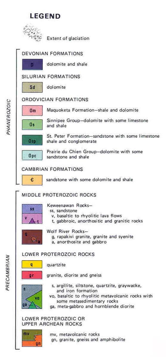
3 Bedrock Geology

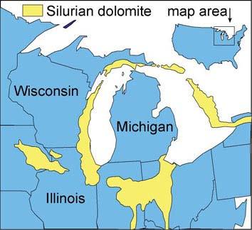
4 Silurian Dolomite Aquifer


5 Silurian Dolomite Aquifer


6 Silurian Dolomite Aquifer Rapid downward flow in vertical fracture network Rapid lateral flow along bedding-plane parallel fractures Some of these flow zones are laterally continuous at the scale of kilometers

7 miles kilometers locations of wells and rain gauge used in this study other municipal wells
8 8/20/99 9/19/99 10/19/99 11/18/99 12/18/99 1/17/00 2/16/00 3/17/00 4/16/00 5/16/00 6/15/00 7/15/00 8/14/ date electrical conductivity, ms/cm precip, in fluid temp, o C Well DR-265 Door Co Hwy Garage Precipitation electrical conductivity Downgradient temperature 250 ft below surface; cased to 170 ft 1 0.5
9 Water Quality Variation NO 3 -N values from three domestic wells completed in the Silurian dolomite Similarity of response in wells located miles apart suggests a diffuse rather than point source of contamination Well 20 Well 56 Well 61 MW-1 Head Precipitation JFMAMJJASONDJFMAMJJASONDJFMAMJJASONDJFMAMJJASONDJFMAMJJA

10 Carbonate is uppermost bedrock Surficial materials < 50 ft thick
 pє PreCambrian Bedrock Gotkowitz & Gaffield, 2004 Draft pє M Fm Sinn Grp Ancell, PdC,")
11 Case Study 1: Calumet County Sinnipee Dolomite Maquoketa Shale 1000 Lake Winnebago Silurian Dolomite Q Quaternary Glacial Deposits Sil Grp Silurian Dolomite M Fm Maquoketa Formation Sinn Grp Sinnipee Dolomite Ancell, Prairie du Chein, Undifferentiated Cambrian Formations (Sandstone & Dolomite) pє PreCambrian Bedrock Gotkowitz & Gaffield, 2004 Draft pє M Fm Sinn Grp Ancell, PdC, Є Sil Grp Q

12 Test results 45% < 2 ppm 29% 2 10 ppm 26% > 10 ppm Nitrate Sampling Data and maps provided by Katie Hemauer Calumet County Land & Water Conservation Dept

13 Coliform Bacteria Test results 35% of wells tested positive for coliform bacteria Data and maps provided by Katie Hemauer Calumet County Land & Water Conservation Dept


14 Calumet Co GW Summit County personnel invited approximately 25 folks with expertise in nutrient management, soils, geology & hydrogeology to attend a summit in early April Wanted an answer to the question How do we farm these areas and not degrade groundwater quality?

15 NRCS Nutrient Management Standards Addresses the application and budgeting of nutrients for plant production All nutrient sources shall be properly credited & utilized Goal is to not apply in excess of crop needs nutrient-mngmt/pdf/590_proposed_final_draft.pdf

16 NRCS Nutrient Management Standards Specific prohibitions for karst and fractured rock areas Recommendations for karst and fractured rock areas Have 6-month storage capacity for manure Apply manure and incorporate into soil twice yearly Credit manure application in nutrient management plan Will it help?


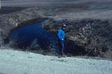
17 Barnyard Monitoring Project was designed to monitor groundwater quality at two barnyards before and after the introduction of Best Management Practices
 > 4 mg/l in")
18 Barnyard Monitoring Installed 2 to 3 piezometers/hole Monitored 1-yr prior to initiation of BMPs and 2 yr after Measured nitrate-n at >300 mg/l in water flowing into bedding plane cave Never detected nitrate-n (or other forms of N) > 4 mg/l in wells
19 Case Study 2: Landfill Expansion An existing landfill in Manitowoc County is reaching capacity and is looking to expand. Site geology consists of approximately ft of glacial sediment (tills & outwash) over Silurian dolomite. In portions of the proposed expansion the watertable lies within the dolomite. DNR is concerned about the ability to effectively monitor and remediate the site. The landfill owner and their consultants feel that the site characterization was conducted according to code and should be adequate.

20 Case Study 2 The landfill siting process is WI is very proscribed. The current code specifies the data that should be included in the various required reports. There are no specifications or guidelines that require fractured rock sites to be characterized any differently than porous medium sites. wm/solid/landfill/siting.htm

21 Site Characterization The site conceptual model guides characterization Continuum Discrete fracture These data illustrate the effect of test scale on measured hydraulic conductivity values Data were collected from the same corehole
22 Case Study 2: Landfill Expansion
23 Summary Existing water quality data indicate that the Silurian dolomite aquifer is quite vulnerable to contamination (evens in areas with 10 s of ft of surficial sediment). We are just beginning to develop agricultural BMPs for these settings and we have few to no data on their effectiveness. Obtaining such data would be costly. While there are some guidelines for the characterization of fractured rock sites, the state of the practice for many (not all) sites is to treat them as porous media sites.
Hydrogeology of Karst NE Wisconsin. Dr. Maureen A. Muldoon UW-Oshkosh Geology Department
 Hydrogeology of Karst NE Wisconsin Dr. Maureen A. Muldoon UW-Oshkosh Geology Department WI Bedrock Outline Karst Landscapes Existing WQ Data Flow in Karst Aquifers Overview of Silurian Aquifer Water Level
Groundwater in Bayfield County
 Groundwater in Bayfield County Presented to Bayfield County Large Scale Livestoc Study Committee April 23, 2015 Madeline Gotowitz Hydrogeologist Groundwater in Bayfield County Groundwater basics Hydrogeology
Wisconsin s Hydrogeology: an overview
 2012 Soil and Water Conservation Society Conference Stevens Point, WI Feb 9, 2012 Wisconsin s Hydrogeology: an overview Ken Bradbury Wisconsin Geological and Natural History Survey University of Wisconsin-Extension
ILLINOIS GROUNDWATER - BEDROCK
 ILLINOIS GROUNDWATER - BEDROCK Northern Illinois Fresh Water Water Supply Shallow Bedrock Aquifers < 500 depth Deep Bedrock Aquifers > 500 depth Southern Illinois Saline water Oil Fracking Coal Waste injection
URBAN HYDROLOGY: WATER IN THE CITY OF TSHWANE Plant Sciences Auditorium, University of Pretoria January 2014 URBAN HYDROGEOLOGY
 URBAN HYDROLOGY: WATER IN THE CITY OF TSHWANE Plant Sciences Auditorium, University of Pretoria 23 24 January 2014 URBAN HYDROGEOLOGY MATTHYS A. DIPPENAAR DEPARTMENT GEOLOGY, UNIVERSITY OF PRETORIA HYDROGEOLOGY
Hydraulic and Water-Quality Characterization of Fractured-Rock Aquifers Using Borehole Geophysics
 Hydraulic and Water-Quality Characterization of Fractured-Rock Aquifers Using Borehole Geophysics John H. Williams Office of Ground Water Troy, New York Flow in Open Borehole Runkel and others (2003) Ambient
Finding Large Capacity Groundwater Supplies for Irrigation
 Finding Large Capacity Groundwater Supplies for Irrigation December 14, 2012 Presented by: Michael L. Chapman, Jr., PG Irrigation Well Site Evaluation Background Investigation Identify Hydrogeologic Conditions
Harvey Thorleifson, Director, Minnesota Geological Survey. Status of geological mapping needed for groundwater protection in Minnesota
 Harvey Thorleifson, Director, Minnesota Geological Survey Status of geological mapping needed for groundwater protection in Minnesota Minnesota is located between the Dakotas and Wisconsin, north of Iowa,
11/22/2010. Groundwater in Unconsolidated Deposits. Alluvial (fluvial) deposits. - consist of gravel, sand, silt and clay
 deposits. - consist of gravel, sand, silt and clay") Groundwater in Unconsolidated Deposits Alluvial (fluvial) deposits - consist of gravel, sand, silt and clay - laid down by physical processes in rivers and flood plains - major sources for water supplies
Groundwater in Unconsolidated Deposits Alluvial (fluvial) deposits - consist of gravel, sand, silt and clay - laid down by physical processes in rivers and flood plains - major sources for water supplies
WELL PLUGGING PROCEDURES
 PUBLIC INFORMATION CIRCULAR JULY 1971 NUMBER I OPTIMAL WELL PLUGGING PROCEDURES BY ORVILLE J VAN ECK IOWA GEOLOGICAL SURVEY SAMUEL J. TUTHILL, State Geologist Iowa City OPTIMAL WELL PLUGGING PROCEDURES
Assessing the Tier 2 Trigger for Fractured Sedimentary Bedrock Sites
 Assessing the Tier 2 Trigger for Fractured Sedimentary Bedrock Sites Ken Lyon, Jennifer Arnold, Louise Burden Advisian WorleyParsons Group RemTech 2015, October 16, Banff, AB INTRODUCTION High level look
Napa Valley Groundwater Sustainability: A Basin Analysis Report for the Napa Valley Subbasin
 Napa Valley Groundwater Sustainability: A Basin Analysis Report for the Napa Valley Subbasin A report prepared pursuant to California Water Code Section 10733.6(b)(3) EXECUTIVE SUMMARY (354.4(A)) 1 1.0
Water Framework Directive. Groundwater Monitoring Programme. Site Information. Kiltrough PWS
 Water Framework Directive Groundwater Monitoring Programme Site Information Kiltrough PWS ImagePath1: Kiltrough PWS\17_009_Kiltough_P1_SiteLo cation.jpg This monitoring point is a well that is part of
Florida s Karst Geology
 Florida s Karst Geology Orange Creek Basin Interagency Working Group Public Workshop, November 5 th, 2015 Harley Means, P.G. Assistant State Geologist Florida Geological Survey Karst Karst a type of topography
Jim Turenne. Soils on Social Media
 Jim Turenne USDA-NRCS 60 Quaker Lane, Suite 46 Warwick, RI. 02886 401-822-8832 Jim.turenne@ri.usda.gov Soils on Social Media www.twitter.com/soilsne www.fb.com/soilsne www.nesoil.com U.S. Department of
Groundwater Hydrology
 EXERCISE 12 Groundwater Hydrology INTRODUCTION Groundwater is an important component of the hydrologic cycle. It feeds lakes, rivers, wetlands, and reservoirs; it supplies water for domestic, municipal,
FRACTURE TRACES AND PRODUCTIVITY OF MUNICIPAL WELLS IN THE MADISON LIMESTONE, RAPID CITY, SOUTH DAKOTA
 Proceedings of the South Dakota Academy of Science, Vol. 87 (2008) 261 FRACTURE TRACES AND PRODUCTIVITY OF MUNICIPAL WELLS IN THE MADISON LIMESTONE, RAPID CITY, SOUTH DAKOTA Perry H. Rahn Department of
Procedure for Determining Near-Surface Pollution Sensitivity
 Procedure for Determining Near-Surface Pollution Sensitivity Minnesota Department of Natural Resources Division of Ecological and Water Resources County Geologic Atlas Program March 2014 Version 2.1 I.
Geophysical Exploration in Water Resources Assessment. John Mundell, P.E., L.P.G., P.G. Ryan Brumbaugh, L.P.G. Mundell & Associates, Inc.
 Geophysical Exploration in Water Resources Assessment John Mundell, P.E., L.P.G., P.G. Ryan Brumbaugh, L.P.G. Mundell & Associates, Inc. Presentation Objective Introduce the use of geophysical survey methods
PHASE II LARAMIE MONITOR WELL PROJECT REPORT
 PHASE II LARAMIE MONITOR WELL PROJECT REPORT June 18, 2015 Submitted to: City of Laramie P.O. Box C Laramie, Wyoming 82073 Prepared by: Bern Hinckley, P.G. Chris Moody, P.G. Hinckley Consulting Wyoming
Cappog Bridge (PW-3)
") Water Framework Directive Groundwater Monitoring Programme Site Information Cappog Bridge (PW-3) ImagePath1: Cappog Bridge\IEGBNI_NB_G_012_18_0 01_A_SiteLocation.jpg Cappog Bridge PW-3 is one of 8 boreholes
Water Framework Directive Groundwater Monitoring Programme Site Information Cappog Bridge (PW-3) ImagePath1: Cappog Bridge\IEGBNI_NB_G_012_18_0 01_A_SiteLocation.jpg Cappog Bridge PW-3 is one of 8 boreholes
 12 10 8 6 4 2 0 40-50 50-60 60-70 70-80 80-90 90-100 Fresh Water What we will cover The Hydrologic Cycle River systems Floods Groundwater Caves and Karst Topography Hot springs Distribution of water in
Maggie Payne Jim Turenne
 Maggie Payne Jim Turenne USDA-NRCS 60 Quaker Lane, Suite 46 Warwick, RI. 02886 401-822-8832 maggie.payne@ri.usda.gov U.S. Department of Agriculture 1935: Soil Conservation Service (SCS) Natural Resources
Water Framework Directive. Groundwater Monitoring Programme. Site Information. Galbally
 Water Framework Directive Groundwater Monitoring Programme Site Information Galbally ImagePath1: Galbally\Galbally1.jpg Galbally source is comprised of 2 boreholes situated in Devonian Old Red Sandstones
iii CONTENTS vii ACKNOWLEDGMENTS EXECUTIVE SUMMARY INTRODUCTION Study Area Data Sources Preparation of Geologic Maps
 CONTENTS ACKNOWLEDGMENTS EXECUTIVE SUMMARY INTRODUCTION Study Area Data Sources Preparation of Geologic Maps GEOLOGY Bedrock Geology Succession and Distribution Structural Features Description of Bedrock
HYDRAULIC CONDUCTIVITY AND SPECIFIC STORAGE OF THE MAQUOKETA SHALE
 HYDRAULIC CONDUCTIVITY AND SPECIFIC STORAGE OF THE MAQUOKETA SHALE A Final Report prepared for the UNIVERSITY OF WISCONSIN WATER RESOURCES INSTITUTE Prepared by Timothy T. Eaton 1,2 David J. Hart 2 Kenneth
A final report prepared for the University of Wisconsin Water Resources Institute
 GEOCHEMICAL CHARACTERIZATION OF SULFIDE MINERALIZATION IN EASTERN WISCONSIN CARBONATE ROCKS A final report prepared for the University of Wisconsin Water Resources Institute J. A. Luczaj Department of
A Risk-based Groundwater Modelling Study for Predicting Thermal Plume Migration from SAGD Well-pads
 A Risk-based Groundwater Modelling Study for Predicting Thermal Plume Migration from SAGD Well-pads Rudy Maji, Ph.D., Golder Associates Solaleh Khezri, M.Sc., AB Scientific Intern (Golder Associates) Don
Aquitard Characterization The Legend of Indiana s Magic Clay Layer. Juliet Port, LPG #2214 July 2014
 Aquitard Characterization The Legend of Indiana s Magic Clay Layer Juliet Port, LPG #2214 July 2014 Topics What is an Aquitard? Why do we care? Review of Indiana glacial geology Conceptual Framework Investigation
The Geology and Hydrogeology of the Spyhill Area
 The Geology and Hydrogeology of the Spyhill Area Clare North (WorleyParsons Komex) and Martin Ortiz (The City of Calgary) 2-Jul-08 Outline Background Site Location Existing Information New Work Geology
Proposed Cemetery Thornhill Road. Tier One Hydrogeological Risk Assessment. Peter Mitchell Associates
 Proposed Cemetery Thornhill Road Tier One Hydrogeological Risk Assessment Peter Mitchell Associates January 2015 Executive Summary This report uses a desk-based risk assessment technique published by the
Back-to-Basics Part 1: Developing the CSM & Site Characterization
 Back-to-Basics Part 1: Developing the CSM & Site Characterization Agenda What is a CSM and how do you use it Physical Components (Geology, Hydrogeology, and Chemistry) Site Use History Likely Fate and
Differentiation of chloride source using stable chlorine isotopes
 Differentiation of chloride source using stable chlorine isotopes RemTech 2009 Banff, Alberta October 14-16 2009 Dr. Alec Blyth and Tom Anthony 1 1 currently City of Calgary Background: DOW Chemical Canada
Chapter 2. Regional Landscapes and the Hydrologic Cycle
 Chapter 2. Regional Landscapes and the Hydrologic Cycle W. Lee Daniels Department of Crop and Soil Environmental Sciences, Virginia Tech Table of Contents Introduction... 23 Soils and landscapes of the
STUDY GUIDE FOR CONTENT MASTERY. Surface Water Movement
 Surface Water SECTION 9.1 Surface Water Movement In your textbook, read about surface water and the way in which it moves sediment. Complete each statement. 1. An excessive amount of water flowing downslope
A High Resolution Vertical Gradient Approach for Delineation of Hydrogeologic Units at a Contaminated Sedimentary Rock Field Site
 A High Resolution Vertical Gradient Approach for Delineation of Hydrogeologic Units at a Contaminated Sedimentary Rock Field Site Jessica Meyer 2013 - Solinst Symposium High Resolution, Depth-Discrete
Applied Geophysics for Environmental Site Characterization and Remediation
 Applied Geophysics for Environmental Site Characterization and Remediation MSECA Webinar September 24, 2015 John Mundell, P.E., L.P.G. Ryan Brumbaugh, L.P.G. MUNDELL & ASSOCIATES, INC. Webinar Objective
Chapter 8 Fetter, Applied Hydrology 4 th Edition, Geology of Groundwater Occurrence
 Chapter 8 Fetter, Applied Hydrology 4 th Edition, 2001 Geology of Groundwater Occurrence Figure 8.42. Alluvial Valleys ground-water region. Fetter, Applied Hydrology 4 th Edition, 2001 Fetter, Applied
Ground-Water Exploration in the Worthington Area of Nobles County: Summary of Seismic Data and Recent Test Drilling Results
 Ground-Water Exploration in the Worthington Area of Nobles County: Summary of Seismic Data and Recent Test Drilling Results Jim Berg and Todd Petersen Geophysicists, DNR Waters January 2000 Table of Contents
ADDITIONAL REGIONAL GROUNDWATER QUALITY DATA. Bernard E, Hoyer Chief, Technical Services Group
 Iowa Geological Survey Contract Report; April 15, 1983 Open File Report 83-1 ADDITIONAL REGIONAL GROUNDWATER QUALITY DATA FROM THE KARST-CARBONATE AQUIFERS OF NORTHEAST IOWA George R. Chief, Geological
Shasta Valley Groundwater Basin Boundary Modification
 Shasta Valley Groundwater Basin Boundary Modification Sustainable Groundwater Management Act (SGMA) September 2014 Governor Brown signs legislation requiring groundwater resources be managed by local agencies
Water Framework Directive. Groundwater Monitoring Programme. Site Information. Drum Bingahamstown
 Water Framework Directive Groundwater Monitoring Programme Site Information Drum Bingahamstown ImagePath1: Drum Bingahamstown\IE_WE_G_16_ 1_a_Spring.jpg Drum Binghamstown is a spring that is used for a
MAPPING BEDROCK: Verifying Depth to Bedrock in Calumet County using Seismic Refraction
 MAPPING BEDROCK: Verifying Depth to Bedrock in Calumet County using Seismic Refraction Revised December 13, 2011 Dave Hart Wisconsin Geological and Natural History Survey INTRODUCTION Seismic refraction
CK-UNIT MAPPING OF GEOLOGIC MATERIALS IN ILLINOIS TO A DEPTH OF 15 METERS
 s 14.GS: CIR 542 c.4 - CK-UNIT MAPPING OF GEOLOGIC MATERIALS IN ILLINOIS TO A DEPTH OF 15 METERS llun.ots GEOLOGICAL survey LIBRARY r Richard C. Berg and John P. Kempton ILLINOIS STATE GEOLOGICAL SURVEY
Association of Environmental & Engineering Geologists (AEG) To join AEG: Student membership is Free! Ask about our scholarships.
 To join AEG: Student membership is Free! Ask about our scholarships.") Association of Environmental & Engineering Geologists (AEG) To join AEG: www.aegweb.org/join Student membership is Free! Ask about our scholarships. What is the Association of Environmental & Engineering
Association of Environmental & Engineering Geologists (AEG) To join AEG: www.aegweb.org/join Student membership is Free! Ask about our scholarships. What is the Association of Environmental & Engineering
MIDDLE NORTH PLATTE GLENDO WATERSHED LEVEL 1 STUDY JUNE 2016
 MIDDLE NORTH PLATTE GLENDO WATERSHED LEVEL 1 STUDY JUNE 2016 WHAT IS A WATERSHED STUDY? o A COMPREHENSIVE EVALUATION, analysis and description of the land and water resources within a watershed o GATHERS
MAPPING GROUNDWATER VULNERABILITY IN SCOTLAND: A NEW APPROACH FOR THE WATER FRAMEWORK DIRECTIVE
 MAPPING GROUNDWATER VULNERABILITY IN SCOTLAND: A NEW APPROACH FOR THE WATER FRAMEWORK DIRECTIVE B E Ó Dochartaigh 1, D F Ball 1, A M MacDonald 1, A Lilly 2, V Fitzsimons 3, M del Rio 1 and C A Auton 1
SEASONAL WATER STORAGE AND REPLENISHMENT OF A FRACTURED GRANITE AQUIFER USING ASR WELLS
 SEASONAL WATER STORAGE AND REPLENISHMENT OF A FRACTURED GRANITE AQUIFER USING ASR WELLS Mario R. Lluria; Phillip M. Paski; Gary G. Small HydroSystems, Incorporated Phoenix, Arizona USA Presentation Contents
the Quarrying Industry Dewatering and the Quarrying Industry the Quarrying Industry
 Dewatering and the Quarrying Industry Dewatering and Dewatering and the Quarrying Industry the Quarrying Industry Les Brown Eugene P. Daly John Kelly Objectives 1) To present a summary of water management
Geologic Mapping in Northeastern Illinois. What do we know about. Donald A. Keefer, Director Geologic Mapping and Hydrogeology Center
 Geologic Mapping in Northeastern Illinois & What do we know about Lake County s Geology? Donald A. Keefer, Director Geologic Mapping and Hydrogeology Center Societal Benefits of Mapping Water Supply Delineation,
What we will cover. The Hydrologic Cycle. River systems. Floods. Groundwater. Caves and Karst Topography. Hot springs
 Fresh Water What we will cover The Hydrologic Cycle River systems Floods Groundwater Caves and Karst Topography Hot springs On a piece of paper, put these reservoirs of water in to order from largest to
DETECTION OF GROUNDWATER POLLUTION USING RESISTIVITY IMAGING AT SERI PETALING LANDFILL, MALAYSIA
 JOURNAL OF ENVIRONMENTAL HYDROLOGY The Electronic Journal of the International Association for Environmental Hydrology On the World Wide Web at http://www.hydroweb.com VOLUME 8 2000 DETECTION OF GROUNDWATER
Groundwater Assessment Report Resource Document for Environmental Impact Statement
 Groundwater Assessment Report Resource Document for Environmental Impact Statement Dakota County, Minnesota Prepared for University of Minnesota June 30, 2009 rjmmmrmqv Groundwater Assessment Report Resource
Groundwater. (x 1000 km 3 /y) Reservoirs. Oceans Cover >70% of Surface. Groundwater and the. Hydrologic Cycle
 Reservoirs. Oceans Cover >70% of Surface. Groundwater and the. Hydrologic Cycle") Chapter 13 Oceans Cover >70% of Surface Groundwater and the Hydrologic Cycle Oceans are only 0.025% of Mass Groundwater Groundwater is liquid water that lies in the subsurface in fractures in rocks and
Chapter 13 Oceans Cover >70% of Surface Groundwater and the Hydrologic Cycle Oceans are only 0.025% of Mass Groundwater Groundwater is liquid water that lies in the subsurface in fractures in rocks and
Groundwater Resources of Missouri. Cynthia Brookshire, R. G.
 Groundwater Resources of Missouri Cynthia Brookshire, R. G. GROUNDWATER... Water beneath the Earth s surface within a zone of saturation AQUIFER... A geologic formation or group of formations that are
Lines-of-Evidence Approach to the Evaluation of Stray Gas Incidents
 Lines-of-Evidence Approach to the Evaluation of Stray Gas Incidents Lisa Molofsky, Ann Smith, John Connor, Shahla Farhat GSI Environmental Inc. Tom Wagner, Albert Wylie Cabot Oil and Gas Corporation GSI
GEOCHEMISTRY UNIFORM SYLLABUS
 GEOCHEMISTRY UNIFORM SYLLABUS The Association of Professional Engineers and Geoscientists of the Province of British Columbia Note: 1. This Syllabus May Be Subject To Change 2. These Courses Are Required
The Niagara Escarpment extends from western New York, through the GTA all the way up to Manitoulin Island and into Michigan and Wisconsin.
 is southern Ontario s most prominent topographic feature, extending more than 500 kilometres from western New York, through Niagara Falls and the western part of the Greater Toronto Area (GTA), and north
Oak Ridges Moraine Aquifer Vulnerability Mapping
 Accompanying Document to the Reference Map for Ontario Regulation 140/02 (Oak Ridges Moraine Conservation Plan) March 2004 2 1. Purpose of Report Accompanying Document to the Reference Map for Ontario
3.0 GEOLOGY AND HYDROGEOLOGY
 3.0 GEOLOGY AND HYDROGEOLOGY 3.1 Methodology The Geological Survey of Ireland (GSI) publication Geology of South Cork was consulted to establish the nature of the bedrock lithology and Quaternary sediments.
Napa Valley Groundwater Sustainability: A Basin Analysis Report for the Napa Valley Subbasin
 Napa Valley Groundwater Sustainability: A Basin Analysis Report for the Napa Valley Subbasin December 13, 2016 Napa County Board of Supervisors By Vicki Kretsinger Grabert and Reid Bryson Basin Analysis
Towards Seamless Interactions Between Geologic Models and Hydrogeologic Applications
 Towards Seamless Interactions Between Geologic Models and Hydrogeologic Applications Ross, M. 1, M. Parent 2, R. Martel 1, and R. Lefebvre 1 1 Institut National de la Recherche Scientifique (INRS-ETE),
How & Where does infiltration work? Summary of Geologic History Constraints/benefits for different geologic units
 June 26, 2007: Low Impact Development 1 Associated Earth Sciences, Inc. Associated Earth Sciences, Inc. Presented by: Matthew A. Miller, PE April 24, 2012 How & Where does infiltration work? Summary of
R ENW Services - Geophysics & GIS
 Yankton Block 1 Vermillion Block 2 N 2 0 1 Block 3 Elk Point 2 3 4 5 6 MILES Block 4 R20-2002-01 0 1 2 3 4 5 6 7 8 9 10 KILOMETERS Block 5 Figure courtesy of ENW Services - Geophysics & GIS Block 6 Test
Simulation of Ground-Water Flow in the Cedar River Alluvial Aquifer Flow System, Cedar Rapids, Iowa
 Prepared in cooperation with the City of Cedar Rapids Simulation of Ground-Water Flow in the Cedar River Alluvial Aquifer Flow System, Cedar Rapids, Iowa Scientific Investigations Report 2004-5130 U.S.
Geophysical Methods for Screening and Investigating Utility Waste Landfill Sites in Karst Terrain
 Geophysical Methods for Screening and Investigating Utility Waste Landfill Sites in Karst Terrain Gary Pendergrass, PE, RG, F.NSPE Principal Geological Engineer Kansas City Geotechnical Conference 2017
Description DESCRIPTION
 DESCRIPTION The location of the Upper James Watershed is located in northeastern South Dakota as well as southeastern North Dakota. It includes the following counties located in North Dakota Barnes, Dickey,
Land-Use Decisions and Geology: Getting Past Out of Sight, Out of Mind Myrna M. Killey and Richard C. Berg
 Land-Use Decisions and Geology: Getting Past Out of Sight, Out of Mind Myrna M. Killey and Richard C. Berg Geoscience Education Series 18 2004 Cover photo: Urban development in Champaign County. As communities
Hydraulic Impacts of Limestone Quarries and Gravel Pits. Jeff Green Minnesota DNR-Division of Ecological & Water Resources
 Hydraulic Impacts of Limestone Quarries and Gravel Pits Jeff Green Minnesota DNR-Division of Ecological & Water Resources The Hydraulic Impacts of Limestone Quarries and Gravel Pits Study was funded by
CCR GROUNDWATER MONITORING SYSTEM CERTIFICATION SCRUBBER SOLIDS POND NO.
 CCR GROUNDWATER MONITORING SYSTEM CERTIFICATION SCRUBBER SOLIDS POND NO. 3 Sherburne County (Sherco) Generating Plant Becker, Minnesota Prepared for: Northern States Power Company, a Minnesota Corporation
WATER ON AND UNDER GROUND. Objectives. The Hydrologic Cycle
 WATER ON AND UNDER GROUND Objectives Define and describe the hydrologic cycle. Identify the basic characteristics of streams. Define drainage basin. Describe how floods occur and what factors may make
Hillslope Hydrology Q 1 Q Understand hillslope runoff processes. 2. Understand the contribution of groundwater to storm runoff.
 Objectives Hillslope Hydrology Streams are the conduits of the surface and subsurface runoff generated in watersheds. SW-GW interaction needs to be understood from the watershed perspective. During a storm
Before writing the discipline examinations, candidates must have passed, or have been exempted from, the Basic Studies Examinations.
 INTRODUCTION The Canadian Engineering Qualifications Board of Engineers Canada issues the Examination Syllabus that includes a continually increasing number of engineering disciplines. Each discipline
Identifying Sensitive Aquifers in Ohio
 State of Ohio Environmental Protection Agency Division of Drinking and Ground Waters Identifying Sensitive Aquifers in Ohio May 2007 Ted Strickland, Governor Chris Korleski, Director Acknowledgments Ohio
Regional groundwater mapping and model
 Regional groundwater mapping and model Boyd, Dwight 1, Steve Holysh 2, and Jeff Pitcher 1 1 Grand River Conservation Authority, Canada; 2 Regional Municipality of Halton, Canada The Grand River forms one
3.5 SOILS, GEOLOGY AND HYDROGEOLOGY
 3.5 SOILS, GEOLOGY AND HYDROGEOLOGY 3.5.1 INTRODUCTION 3.5.1.1 This chapter of the describes the Soils, Geology and Hydrogeology in the existing environment surrounding the proposed development. This chapter
Groundwater in Bedrock Aquifers: Development Considerations
 Slide 1 Groundwater in Bedrock Aquifers: Development Considerations Pelham, New Hampshire October 3, 2016 Building Trust. Engineering Success. Slide 2 OUTLINE Background on groundwater in bedrock aquifers
Oola PWS - Carrigmore BH
 Water Framework Directive Groundwater Monitoring Programme Site Information Oola PWS - Carrigmore BH ImagePath1: Oola PWS - Carrigmore BH\OolaPWSCarrigmore1.jpg Oola PWS Carrigmore BH is a borehole used
Application of Nitrogen and Oxygen Isotopes to Identify Sources of Nitrate
 Application of Nitrogen and Oxygen Isotopes to Identify Sources of Nitrate Illinois Groundwater Consortium Conference April 9, 2001 George S. Roadcap, Illinois State Water Survey Keith C. Hackley, Illinois
Karst Topography In order to understand karst topography we must first have a basic understanding of the water cycle, the formation of limestone (carb
 Karst Topography The formation of caves and other associated features in limestone bedrock is called karst topography. Limestone, a sedimentary rock made mostly of the mineral calcite and small amounts
NEAR THE VILLAGE OF NORTH AURORA, ILLINOIS RESULTS OF A SHALLOW SEISMIC REFRACTION SURVEY. Timothy H. Larson. QsuJk Sa^^oJ^M. Philip G.
 557 IL6of 1991-15 QsuJk Sa^^oJ^M RESULTS OF A SHALLOW SEISMIC REFRACTION SURVEY NEAR THE VILLAGE OF NORTH AURORA, ILLINOIS Timothy H. Larson Philip G. Orozco Open File Series 1991-15 ILLINOIS STATE GEOLOGICAL
Groundwater Sensitivity Regions of Kentucky
 Groundwater Sensitivity Regions of Kentucky by Kentucky Department for Environmental Protection Division of Water Groundwater Branch 1994 Interpreted by Joseph A. Ray James S. Webb Phillip W. O'dell Scale
IGMAC 2015: Surficial Geologic Mapping STATEMAP past and future. Valparaiso Moraine, Will County
 IGMAC 2015: Surficial Geologic Mapping STATEMAP past and future Valparaiso Moraine, Will County presented by Drew Phillips, September 10. 2015 SURFICIAL MAPPING Completed Aug 2015 NE Illinois Project:
Cuyama Basin North Fork Vineyard
 Cuyama Basin North Fork Vineyard Company Background plus Data Insights to Support GSP Development for the Cuyama Basin Presented by Grapevine Capital Partners and Cleath-Harris Geologists April 26th, 2018
J.H. Campbell Generating Facility Pond A - Location Restriction Certification Report
 J.H. Campbell Generating Facility Pond A - Location Restriction Certification Report Pursuant to: 40 CFR 257.60 40 CFR 257.61 40 CFR 257.62 40 CFR 257.63 40 CFR 257.64 Submitted to: Consumers Energy Company
Hydrogeology of East-Central Union County, Northeastern New Mexico
 Hydrogeology of East-Central Union County, Northeastern New Mexico Geoffrey Rawling April 2013 New Mexico Bureau of Geology & Mineral Resources 1 What are the important hydrogeologic issues in Union County?
Quantifying shallow subsurface flow and salt transport in the Canadian Prairies
 Quantifying shallow subsurface flow and salt transport in the Canadian Prairies Andrew Ireson GIWS, University of Saskatchewan www.usask.ca/water Uri Nachshon Garth van der Kamp GIWS, University of Saskatchewan
Chapter 13. Groundwater
 Chapter 13 Groundwater Introduction Groundwater is all subsurface water that completely fills the pores and other open spaces in rocks, sediments, and soil. Groundwater is responsible for forming beautiful
Green River Lowland and
 EG 149 14.GS: EGN 149 c. 3 (X^JL^uu^-j Hydrogeology of the Green River Lowland and Associated Bedrock Valleys in Northwestern Illinois David R. Larson Beverly L. Herzog Robert C. Vaiden Cheri A. Chenoweth
Soils of Rhode Island
 Soils of Rhode Island Jim Turenne, RI State Soil Scientist USDA-NRCS 60 Quaker Ln. Suite 46 Warwick, RI. 02886 401-822-8830 http://nesoil.com Jim.turenne@ri.usda.gov About NRCS Established as the Soil
Catastrophic Events Impact on Ecosystems
 Catastrophic Events Impact on Ecosystems Hurricanes Hurricanes An intense, rotating oceanic weather system with sustained winds of at least 74 mph and a welldefined eye Conditions for formation: Warm water
ENVIRONMENTAL ENGINEERING LAND SURVEYING
 ENVIRONMENTL ENGINEERING LND SURVEYING Location Restrictions Otter Tail Power Company Coyote Station Introduction This report presents documentation and certification for the location standards for the
GROUNDWATER MONITORING DATA 2016 SAMPLING EVENT HARSHAW CHEMICAL COMPANY FUSRAP SITE
 GROUNDWATER MONITORING DATA 2016 SAMPLING EVENT HARSHAW CHEMICAL COMPANY FUSRAP SITE U.S. Army Corps of Engineers Buffalo District Building Strong April 2017 ly Utilized Sites Remedial Action Program The
Recharge and Head: Preliminary Findings Using a Long-Term Data Set
 Recharge and Head: Preliminary Findings Using a Long-Term Data Set Abstract Omkar Aphale David Tonjes Department of Technology and Society Stony Brook University The validity of general perceptions or
4.11 Groundwater model
 4.11 Groundwater model 4.11 Groundwater model 4.11.1 Introduction and objectives Groundwater models have the potential to make important contributions in the mapping and characterisation of buried valleys.
' International Institute for Land Reclamation and Improvement. 2 Groundwater Investigations. N.A. de Ridder'? 2.1 Introduction. 2.
 2 Groundwater Investigations N.A. de Ridder'? 2.1 Introduction Successful drainage depends largely on a proper diagnosis of the causes of the excess water. For this diagnosis, one must consider: climate,
ENGINEER S CERTIFICATION OF FAULT AREA DEMONSTRATION (40 CFR )
") PLATTE RIVER POWER AUTHORITY RAWHIDE ENERGY STATION BOTTOM ASH TRANSFER (BAT) IMPOUNDMENTS LARIMER COUNTY, CO ENGINEER S CERTIFICATION OF FAULT AREA DEMONSTRATION (40 CFR 257.62) FOR COAL COMBUSTION RESIDUALS
PLATTE RIVER POWER AUTHORITY RAWHIDE ENERGY STATION BOTTOM ASH TRANSFER (BAT) IMPOUNDMENTS LARIMER COUNTY, CO ENGINEER S CERTIFICATION OF FAULT AREA DEMONSTRATION (40 CFR 257.62) FOR COAL COMBUSTION RESIDUALS
Michigan s Geology and Groundwater
 Michigan s Geology and Groundwater Ralph J. Haefner Deputy Director U.S. Geological Survey Michigan-Ohio Water Science Center Lansing, Michigan Outline About the USGS Geology 101 Michigan s geology Bedrock
THE ROLE OF 3-D GEOLOGIC MODELING AND DATABASE SOLUTIONS IN THE VIRTTAANKANGAS ARTIFICIAL RECHARGE PROJECT, SOUTHWESTERN FINLAND
 THE ROLE OF 3-D GEOLOGIC MODELING AND DATABASE SOLUTIONS IN THE VIRTTAANKANGAS ARTIFICIAL RECHARGE PROJECT, SOUTHWESTERN FINLAND Artimo, A. 1, S. Saraperä 2, and I. Ylander 1 1 Turku Region Water Ltd.,
Weathering and Soil Formation. Chapter 10
 Weathering and Soil Formation Chapter 10 Old and New Mountains The Appalachian Mountains appear very different from the Sierra Mountains. The Appalachians are smaller, rounded, gently sloping, and covered