Groundwater Sequence Stratigraphy:
|
|
|
- Ellen Hines
- 5 years ago
- Views:
Transcription


1 Groundwater Sequence Stratigraphy: A Geology-based Approach for Developing Accurate and Representative Hydrogeologic Conceptual Models for Successful Groundwater Sustainability Plans Rick Cramer, Burns & McDonnell Chris Bonds, CA-DWR; Mike Shultz, Burns & McDonnell; Colin Plank, Burns & McDonnell; Galen Kenoyer, Burns & McDonnell May 4,

2 Each Plan shall include a descriptive hydrogeologic conceptual model of the basin based on technical studies and qualified maps that characterizes the physical components and interaction of the surface water and groundwater systems in the basin 2
3 From BMP Document Geologic cross-sections should be constructed by a professional geologist A full understanding of, and appreciation for, the variety of depositional environments, like sequence stratigraphy, is needed to construct accurate geological cross sections. 3

.")


4 Focus on Geology in the Oil Industry 1960s In the early days of exploration and production production was limited by facilities capacity (engineering focus). However, as production declined the geology became increasingly critical for economical operations. Billions of dollars have been invested in research and development of stratigraphic controls on fluid flow. 4

5 Focus on Geology in Environmental Industry 2013 At least 126,000 sites across the U.S. have contaminated groundwater that requires remediation Over 12,000 of these sites are considered "complex" due to inherent geologic complexities, restoration within the next years is likely not achievable. Alternatives for Managing the Nation's Complex Contaminated Groundwater Sites National Academy of Sciences Committee on Future Options for Management in the Nation's Subsurface Remediation Effort,
 as an emerging best practice for Conceptual Site Models (Burns & McDonnell) 6")
6 Environmental Sequence Stratigraphy Technology Considered Best Practice by US EPA US EPA Technical Issue Paper presents Environmental Sequence Stratigraphy (ESS) as an emerging best practice for Conceptual Site Models (Burns & McDonnell) 6


7 Water supply studies based on assumptions of homogeneous and isotropic conditions, steady-state observations Groundwater Production Industry Traditional Approach to the Subsurface Groundwater gradient = groundwater flow 7


8 Geology-Based HCM: Groundwater Sequence Stratigraphy (GSS) Process Borehole Log to Graphic Grainsize Log Grain-size increasing Map Cross Section 0 Clay Gravel 100 Uncon Depth (Ft - MSL) Uncon 1 Determine depositional environment which is the foundation to the GSS evaluation 2 Leverage existing lithology data: format to emphasize vertical grainsize distribution 3 Predict and Map in 3D the subsurface conditions away from the data points 8
9 GSS is Pattern Recognition Depositional environments have distinctive vertical grain size distributions 9
10 GSS is Pattern Recognition Depositional environments have distinctive vertical grain size distributions 1
11 GSS is Pattern Recognition Depositional environments have distinctive vertical grain size distributions 1
12 GSS is Pattern Recognition Depositional environments have distinctive vertical grain size distributions 1


13 GSS is Pattern Recognition Depositional environments have distinctive vertical grain size distributions 1

14 GSS is Pattern Recognition and the associated sand bodies have characteristic/predictable dimensions and continuity. Stratigrapher using GSS methodology can predict subsurface conditions away from the data points. 1
15 Unleashing the Power of Existing Site Data USCS is not a geologic description of the subsurface Different geologists Different drilling methods Different sampling intervals Etc 1
16 How to tease out detailed stratigraphy with existing data Existing data is formatted for stratigraphic interpretation Reveals the hidden stratigraphic information that is available with existing lithology data 1
17 How to tease out detailed stratigraphy with existing data This SM interval is a fine to medium grained Silty Sand 1
18 How to tease out detailed stratigraphy with existing data This SM interval is a fine to coarse grained Silty Sand with gravel, representative of a channel deposit. 1

19 How to tease out detailed stratigraphy with existing data 1. Reformatting existing data to identify sequences, and 2. Applying facies models, stratigraphic rules of thumb to correlate and map the subsurface, predict character of heterogeneity present Permeable streaks commonly at bases of channel complex Fining-upward cycles indicative of channel-fills 500 feet Example from GW site in S. CA, USA 1

20 Mapped Buried Sand Channels 2


21 USCS-Based Cross Section Mapped Sand Channels ESS-Based Cross Section vs 2

22 Groundwater Production Projects Groundwater Contamination Projects 2

23 Dominguez Gap Seawater Intrusion Barrier, West Coast Basin WRD 2

24 Dominguez Gap Barrier Project 2

25 Dominguez Gap Barrier Project 2


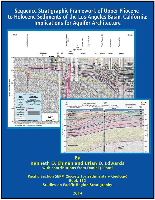
26 Dominguez Gap Seawater Intrusion Barrier, West Coast Basin South North 1000 m Layer Cake aquifer stratigraphy: continuous layers From Ehman and Edwards (2014) Aquifer architecture is much more complicated than previously understood. Implications for Seawater intrusion pathways Contaminant migration pathways 2
27 2

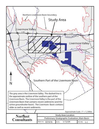
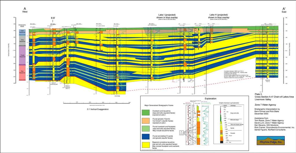
28 Livermore Groundwater Basin - Zone 7 Water Agency 2
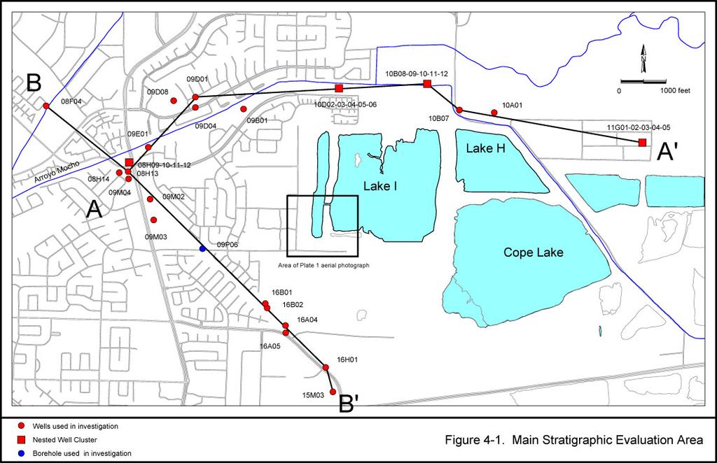
29 2

30 3
31 3
32 Focus on Geology in Groundwater Production Industry?? 3
Environmental Sequence Stratigraphy: A Focus on Geology for Improved Remediation Decision Making
 Environmental Sequence Stratigraphy: A Focus on Geology for Improved Remediation Decision Making Rick Cramer, PG (Burns and McDonnell); Mike Shultz (AECOM); Colin Plank (AECOM); Herb Levine (US EPA, Region
11/22/2010. Groundwater in Unconsolidated Deposits. Alluvial (fluvial) deposits. - consist of gravel, sand, silt and clay
 deposits. - consist of gravel, sand, silt and clay") Groundwater in Unconsolidated Deposits Alluvial (fluvial) deposits - consist of gravel, sand, silt and clay - laid down by physical processes in rivers and flood plains - major sources for water supplies
Groundwater in Unconsolidated Deposits Alluvial (fluvial) deposits - consist of gravel, sand, silt and clay - laid down by physical processes in rivers and flood plains - major sources for water supplies
Soils, Hydrogeology, and Aquifer Properties. Philip B. Bedient 2006 Rice University
 Soils, Hydrogeology, and Aquifer Properties Philip B. Bedient 2006 Rice University Charbeneau, 2000. Basin Hydrologic Cycle Global Water Supply Distribution 3% of earth s water is fresh - 97% oceans 1%
Finding Large Capacity Groundwater Supplies for Irrigation
 Finding Large Capacity Groundwater Supplies for Irrigation December 14, 2012 Presented by: Michael L. Chapman, Jr., PG Irrigation Well Site Evaluation Background Investigation Identify Hydrogeologic Conditions
Sarah Jane Riordan. Australian School of Petroleum University of Adelaide March 2009
 Managing the Interdisciplinary Requirements of 3D Geological Models Sarah Jane Riordan Australian School of Petroleum University of Adelaide March 2009 Thesis submitted in accordance with the requirements
Groundwater Hydrology
 EXERCISE 12 Groundwater Hydrology INTRODUCTION Groundwater is an important component of the hydrologic cycle. It feeds lakes, rivers, wetlands, and reservoirs; it supplies water for domestic, municipal,
Appendix D. Sediment Texture and Other Soil Data
 5 6 7 8 Appendix D. Sediment Texture and Other Soil Data This appendix describes the sediment texture of the aquifer system in the Restoration Area. The contents of this appendix describe the: Importance
PRELIMINARY. Select Geophysical Methods and Groundwater Modeling: Examples from USGS studies. Claudia Faunt and a cast of others
 Select Geophysical Methods and Groundwater Modeling: Examples from USGS studies Claudia Faunt and a cast of others Current Preliminary Studies Stanford Water in the West Groundwater Data Workshop Series:
A method for three-dimensional mapping, merging geologic interpretation, and GIS computation
 A method for three-dimensional mapping, merging geologic interpretation, and GIS computation Soller, David R., U.S. Geological Survey, 908 National Center, Reston, VA 20192 and Richard C. Berg, Illinois
Differentiation of chloride source using stable chlorine isotopes
 Differentiation of chloride source using stable chlorine isotopes RemTech 2009 Banff, Alberta October 14-16 2009 Dr. Alec Blyth and Tom Anthony 1 1 currently City of Calgary Background: DOW Chemical Canada
Buried-valley Aquifers: Delineation and Characterization from Reflection Seismic and Core Data at Caledon East, Ontario
 Buried-valley Aquifers: Delineation and Characterization from Reflection Seismic and Core Data at Caledon East, Ontario Russell, H.A.J. 1, S.E. Pullan 1, J.A. Hunter 1, D.R. Sharpe 1, and S. Holysh 2 1
Monitoring of In-Situ Chemical Oxidation (ISCO) with Time Series Geophysical Surveys
 with Time Series Geophysical Surveys") Monitoring of In-Situ Chemical Oxidation (ISCO) with Time Series Geophysical Surveys Philip T. Harte, P.G. U.S. Geological Survey ptharte@usgs.gov 603-226-7813 U.S. Department of the Interior U.S. Geological
Monitoring of In-Situ Chemical Oxidation (ISCO) with Time Series Geophysical Surveys Philip T. Harte, P.G. U.S. Geological Survey ptharte@usgs.gov 603-226-7813 U.S. Department of the Interior U.S. Geological
HYBRID DETERMINISTIC AND STOCHASTIC HYDROSTRATIGRAPHIC MODELING OF A COMPLEX GLACIAL AQUIFER SYSTEM
 HYBRID DETERMINISTIC AND STOCHASTIC HYDROSTRATIGRAPHIC MODELING OF A COMPLEX GLACIAL AQUIFER SYSTEM Lawrence D. Lemke, Andrew L. Frahm, Lena K. Pappas Department of Geology, Wayne State University, Detroit,
Application of multiple-point geostatistics on modelling groundwater flow and transport in the Brussels Sands
 Application of multiple-point geostatistics on modelling groundwater flow and transport in the Brussels Sands Marijke Huysmans (1) and Alain Dassargues (1,2) (1) Earth and Environmental Sciences, K.U.Leuven,
Basin Analysis Applied to Modelling Buried Valleys in the Great Lakes Basin
 EARTH SCIENCES SECTOR GENERAL INFORMATION PRODUCT 35 Basin Analysis Applied to Modelling Buried Valleys in the Great Lakes Basin Sharpe, D R; Russell, H A J 2004 Originally released as: Basin Analysis
Subsurface Geology of the Kennebec River
 Maine Geologic Facts and Localities July, 1998 Subsurface Geology of the Kennebec River 43 54 40.75 N, 69 48 29.01 W Text by Daniel B. Locke, Department of Agriculture, Conservation & Forestry 1 Map by
Geophysical Study of Limestone Attributes At Abudu Area of Edo State, Nigeria
 Journal of Emerging Trends in Engineering and Applied Sciences (JETEAS) 2 (5): 795-800 Scholarlink Research Institute Journals, 2011 (ISSN: 2141-7016) jeteas.scholarlinkresearch.org Journal of Emerging
Hydrogeologic Conceptual Models for Regional Flow Systems
 Hydrogeologic Conceptual Models for Regional Flow Systems R.T. Hanson, U.S. Geological Survey One Water Hydrologic Flow Model USGS MODFLOW-OWHM Session 4 Groundwater Subbasin Baseline Historic and Current
Alamitos Barrier Improvement Project - UPDATE
 Alamitos Barrier Improvement Project - UPDATE Seal Beach Leisure World Community Meeting Clubhouse 2 August 31, 2016 Orange County Water District Meeting Objectives Overview of OCWD Overview of the Alamitos
RESISTIVITY IMAGING AND BOREHOLE INVESTIGATION OF THE BANTING AREA AQUIFER, SELANGOR, MALAYSIA. A.N. Ibrahim Z.Z.T. Harith M.N.M.
 JOURNAL OF ENVIRONMENTAL HYDROLOGY The Electronic Journal of the International Association for Environmental Hydrology On the World Wide Web at http://www.hydroweb.com VOLUME 11 2003 RESISTIVITY IMAGING
RADIONUCLIDE DIFFUSION IN GEOLOGICAL MEDIA
 GEOPHYSICS RADIONUCLIDE DIFFUSION IN GEOLOGICAL MEDIA C. BUCUR 1, M. OLTEANU 1, M. PAVELESCU 2 1 Institute for Nuclear Research, Pitesti, Romania, crina.bucur@scn.ro 2 Academy of Scientists Bucharest,
ambiguity in earth sciences IESO Geophysics Section Eddy hartantyo, Lab Geofisika FMIPA UGM
 ambiguity in earth sciences IESO Geophysics Section Eddy hartantyo, Lab Geofisika FMIPA UGM Pelatihan Tahap II IESO Teknik Geologi UGM Februari 2009 1 Introduction Photos from http://www.eegs.org/whatis/
THE ROLE OF 3-D GEOLOGIC MODELING AND DATABASE SOLUTIONS IN THE VIRTTAANKANGAS ARTIFICIAL RECHARGE PROJECT, SOUTHWESTERN FINLAND
 THE ROLE OF 3-D GEOLOGIC MODELING AND DATABASE SOLUTIONS IN THE VIRTTAANKANGAS ARTIFICIAL RECHARGE PROJECT, SOUTHWESTERN FINLAND Artimo, A. 1, S. Saraperä 2, and I. Ylander 1 1 Turku Region Water Ltd.,
Cuyama Basin North Fork Vineyard
 Cuyama Basin North Fork Vineyard Company Background plus Data Insights to Support GSP Development for the Cuyama Basin Presented by Grapevine Capital Partners and Cleath-Harris Geologists April 26th, 2018
Antelope Hills Directionally Drilled Water Well. Theresa Jehn-Dellaport Jehn Water Consultants, Inc.
 Antelope Hills Directionally Drilled Water Well Theresa Jehn-Dellaport Directional Well Applications Deep Bedrock Aquifers Proven Oil field technology Initial Analysis indicates up to 4 times the production
Evaluating Geological Formations and Managing Ground-Water Resources: Can We Afford the Effort?
 Evaluating Geological Formations and Managing Ground-Water Resources: Can We Afford the Effort? Stanley T. Paxton & Todd Halihan Oklahoma State University GSA Annual Meeting Salt Lake City, Utah 16-19
10. GEOTECHNICAL EXPLORATION PROGRAM
 Geotechnical site investigations should be conducted in multiple phases to obtain data for use during the planning and design of the tunnel system. Geotechnical investigations typically are performed in
RATE OF FLUID FLOW THROUGH POROUS MEDIA
 RATE OF FLUID FLOW THROUGH POROUS MEDIA Submitted by Xu Ming Xin Kiong Min Yi Kimberly Yip Juen Chen Nicole A project presented to the Singapore Mathematical Society Essay Competition 2013 1 Abstract Fluid
Geologic Considerations of Shallow SAGD Caprock; Seal Capacity, Seal Geometry and Seal Integrity, Athabasca Oilsands, Alberta Canada
 Geologic Considerations of Shallow SAGD Caprock; Seal Capacity, Seal Geometry and Seal Integrity, Athabasca Oilsands, Alberta Canada Gordon T. Stabb, Michael Webb Durando Resources Corp, Suncor Energy
Evaluation of the hydraulic gradient at an island for low-level nuclear waste disposal
 A New Focus on Groundwater Seawater Interactions (Proceedings of Symposium HS1001 at IUGG2007, Perugia, July 2007). IAHS Publ. 312, 2007. 237 Evaluation of the hydraulic gradient at an island for low-level
Procedure for Determining Near-Surface Pollution Sensitivity
 Procedure for Determining Near-Surface Pollution Sensitivity Minnesota Department of Natural Resources Division of Ecological and Water Resources County Geologic Atlas Program March 2014 Version 2.1 I.
Shasta Valley Groundwater Basin Boundary Modification
 Shasta Valley Groundwater Basin Boundary Modification Sustainable Groundwater Management Act (SGMA) September 2014 Governor Brown signs legislation requiring groundwater resources be managed by local agencies
Interpretation and application of hydrogeological concepts to commercial scale brine extraction projects
 Interpretation and application of hydrogeological concepts to commercial scale brine extraction projects ABSTRACT Terry Braun, Pablo Cortegoso*, Cristian Pereira* and Vladimir Ugorets* 1. SRK Consulting
DEPARTMENT OF GEOSCIENCES
 DEPARTMENT OF GEOSCIENCES Office in Natural Resources Building, Room 322 (970) 491-7826 warnercnr.colostate.edu/geosciences-home (http:// warnercnr.colostate.edu/geosciences-home) Richard Aster, Department
An Overview of the Tapia Canyon Field Static Geocellular Model and Simulation Study
 An Overview of the Tapia Canyon Field Static Geocellular Model and Simulation Study Prepared for Sefton Resources Inc. Jennifer Dunn, Chief Geologist Petrel Robertson Consulting Ltd. Outline Background
Autopsy of a Small UST site in Bedrock: Case Study, Devens, MA
 Autopsy of a Small UST site in Bedrock: Implications for ISCO Effectiveness Case Study, Devens, MA William C. Brandon, Hydrogeologist, US EPA Region 1 NEWMOA ISCO WORKSHOP Westford Regency Westford, MA
Evaluation of Subsurface Formation of Pabna District, Bangladesh
 IOSR Journal of Applied Geology and Geophysics (IOSR-JAGG) e-issn: 2321 0990, p-issn: 2321 0982.Volume 1, Issue 4 (Sep. Oct. 2013), PP 30-36 Evaluation of Subsurface Formation of Pabna District, Bangladesh
Somenath Kar*, Krishnendu Ghosh*, Arnab Ghosh*, Koushik Sikdar*, Udit Kumar Guru*, Priyanka Bhattacharya*, K.M Sundaram**, G M Chavan**
 P-419 Summary Characterizing the Clay Particle distribution in Deepwater Channel Levee Complex using Borehole Micro Image and Multi Triaxial Induction Measurement: A Case Studies from Eastern Offshore
Nathan D. Webb and James L. Best
 Nathan D. Webb and James L. Best Background Pennsylvanian oil production Stratigraphy & geologic setting Study area Methods Using geophysical logs & core Results Comparing three channel deposits Implications
Exploration Significance of Unconformity Structure on Subtle Pools. 1 Vertical structure characteristics of unconformity
 Exploration Significance of Unconformity Structure on Subtle Pools Wu Kongyou (China University of Petroleum,College of Geo-Resources and Information,Shandong Qingdao 266555) Abstract: Vertical structure
(Refer Slide Time: 02:10)
") Soil Mechanics Prof. B.V.S. Viswanathan Department of Civil Engineering Indian Institute of Technology, Bombay Lecture 24 Flow of water through soils-v Welcome to lecture five of flow of water through
Soil Mechanics Prof. B.V.S. Viswanathan Department of Civil Engineering Indian Institute of Technology, Bombay Lecture 24 Flow of water through soils-v Welcome to lecture five of flow of water through
Geologging Imagery, Applications and Geological Interpretation. Shea Altadonna 1, Jim Fulton 2, E.I.T.
 Geologging Imagery, Applications and Geological Interpretation Shea Altadonna 1, Jim Fulton 2, E.I.T. 1 Geologist, Advanced Construction Techniques Inc. 1000 N. West St. Ste 1200, Wilmington, DE 19801;
Aquitard Characterization The Legend of Indiana s Magic Clay Layer. Juliet Port, LPG #2214 July 2014
 Aquitard Characterization The Legend of Indiana s Magic Clay Layer Juliet Port, LPG #2214 July 2014 Topics What is an Aquitard? Why do we care? Review of Indiana glacial geology Conceptual Framework Investigation
1.72, Groundwater Hydrology Prof. Charles Harvey Lecture Packet #5: Groundwater Flow Patterns. Local Flow System. Intermediate Flow System
 1.72, Groundwater Hydrology Prof. Charles Harvey Lecture Packet #5: Groundwater Flow Patterns c Local Flow System 10,000 feet Intermediate Flow System Regional Flow System 20,000 feet Hydrologic section
Enhanced Characterization of the Mississippi River Valley Alluvial Aquifer Using Surface Geophysical Methods
 Photo by Shane Stocks, U.S. Geological Survey Enhanced Characterization of the Mississippi River Valley Alluvial Aquifer Using Surface Geophysical Methods Presented by Ryan F. Adams US Geological Survey
Assessing the Tier 2 Trigger for Fractured Sedimentary Bedrock Sites
 Assessing the Tier 2 Trigger for Fractured Sedimentary Bedrock Sites Ken Lyon, Jennifer Arnold, Louise Burden Advisian WorleyParsons Group RemTech 2015, October 16, Banff, AB INTRODUCTION High level look
From 2D Seismic to Hydrodynamic Modelling
 From 2D Seismic to Hydrodynamic Modelling A Complex Study of Turbidites in a Petroleum-Bearing Basin Marcell Lux, HC Exploration Geologist Ahmed Amran, HC Exploration Advisor Marianna Vincze, Geomodel
Pressure Grouting of Fractured Bedrock to Control Acid Mine Drainage
 WATER RESOURCES AT RISK May 14-18, 1995 Denver American Institute of Hydrology Pressure Grouting of Fractured Bedrock to Control Acid Mine Drainage S. A. Effner, G. D. Vandersluis, and V. Straskraba Hydro-Geo
Applied Geophysics for Environmental Site Characterization and Remediation
 Applied Geophysics for Environmental Site Characterization and Remediation MSECA Webinar September 24, 2015 John Mundell, P.E., L.P.G. Ryan Brumbaugh, L.P.G. MUNDELL & ASSOCIATES, INC. Webinar Objective
Advanced processing and inversion of two AEM datasets for 3D geological modelling: the case study of Spiritwood Valley Aquifer
 Advanced processing and inversion of two AEM datasets for 3D geological modelling: the case study of Spiritwood Valley Aquifer Vincenzo Sapia, INGV, Rome, Italy Vincenzo.sapia@ingv.it Andrea Viezzoli,
PETROLEUM GEOSCIENCES GEOLOGY OR GEOPHYSICS MAJOR
 PETROLEUM GEOSCIENCES GEOLOGY OR GEOPHYSICS MAJOR APPLIED GRADUATE STUDIES Geology Geophysics GEO1 Introduction to the petroleum geosciences GEO2 Seismic methods GEO3 Multi-scale geological analysis GEO4
Harvey Thorleifson, Director, Minnesota Geological Survey. Status of geological mapping needed for groundwater protection in Minnesota
 Harvey Thorleifson, Director, Minnesota Geological Survey Status of geological mapping needed for groundwater protection in Minnesota Minnesota is located between the Dakotas and Wisconsin, north of Iowa,
Seismic Reflection Imaging across the Johnson Ranch, Valley County, Idaho
 Seismic Reflection Imaging across the Johnson Ranch, Valley County, Idaho Report Prepared for the Skyline Corporation Lee M. Liberty Center for Geophysical Investigation of the Shallow Subsurface (CGISS)
Geological Survey of Alabama Groundwater Assessment Program
 Geological Survey of Alabama Groundwater Assessment Program Hydrogeologic Characterization and Groundwater Source Development Assessment for Area 2, Southwestern Alabama Gheorghe M. Ponta, Marlon R. Cook,
Storage 6 - Modeling for CO 2 Storage. Professor John Kaldi Chief Scientist, CO2CRC Australian School of Petroleum, University of Adelaide, Australia
 Storage 6 - Modeling for CO 2 Storage Professor John Kaldi Chief Scientist, CO2CRC Australian School of Petroleum, University of Adelaide, Australia Regina, Sask., Canada, 17-22 July, 2016 Modeling 2 What
Geological Mapping using Geophysics
 Geological Mapping using Geophysics Pugin, A.J.M. and T.H. Larson Illinois State Geological Survey, 615 E Peabody Dr., Champaign, IL 61820; E-mail: A.J.M. Pugin at pugin@isgs.uiuc.edu Mapping Techniques.
AWRA PMAS Engineers Club of Philadelphia. A Geologic Perspective on Stormwater
 AWRA PMAS Engineers Club of Philadelphia A Geologic Perspective on Stormwater Toby J. Kessler, P.G. Hydrogeologist Trevor G. Woodward, P.G. Engineering Geologist September 10, 2014 Gilmore & Associates,
PARQUE COLON AGUADILLA (LAND PROPERTY OF MUNICIPIO AGUADA) LOT PROPERTY OF SUNC. ESTEVEZ BW-1 BW-5 BW-2 DB1 BW-3 DB2 BW-4 DB3 GWS-1
 LOT PROPERTY OF SUNC. ESTEVEZ BW-1 BW-5 BW-2 DB1 BW-3 DB2 BW-4 DB3 GWS-1") N 64650 N 64600 N 64550 N 64500 N 64450 N 64400 N 64350 N 64300 N 64250 N 64200 N 64150 N 64100 N 64050 N 64000 N 63950 N 63900 N 63850 N 63800 N 63750 N 63700 N 63650 N 63600 N 63550 N 63500 N 63450 N
N 64650 N 64600 N 64550 N 64500 N 64450 N 64400 N 64350 N 64300 N 64250 N 64200 N 64150 N 64100 N 64050 N 64000 N 63950 N 63900 N 63850 N 63800 N 63750 N 63700 N 63650 N 63600 N 63550 N 63500 N 63450 N
Groundwater in Bedrock Aquifers: Development Considerations
 Slide 1 Groundwater in Bedrock Aquifers: Development Considerations Pelham, New Hampshire October 3, 2016 Building Trust. Engineering Success. Slide 2 OUTLINE Background on groundwater in bedrock aquifers
NEW PRODUCTS AND ADVANCEMENTS IN 3-D MODELLING PROTOCOLS BASED ON STUDIES IN THICK DRIFT AREAS IN ONTARIO, CANADA
 NEW PRODUCTS AND ADVANCEMENTS IN 3-D MODELLING PROTOCOLS BASED ON STUDIES IN THICK DRIFT AREAS IN ONTARIO, CANADA Abigail K. Burt and Andrew F. Bajc Ontario Geological Survey, 933 Ramsey Lake Road, Sudbury,
fregonruleco. 1 U.S.A. 2
 3 5 fregonruleco. 1 U.S.A. 2 557.09773 IL6cr 1985-1 Qojl ^^\ ISGS CONTRACT/GRANT REPORT 1985-1 GEOPHYSICAL STUDIES AT THE SHEFFIELD LOW-LEVEL RADIOACTIVE WASTE DISPOSAL FACILITY TO EVALUATE POTENTIAL PATHWAYS
Lab 9: Petroleum and groundwater
 Geology 101 Name(s): Lab 9: Petroleum and groundwater Petroleum (oil) is a multi-component liquid refined to generate different hydrocarbons, such as heptane (a component of gasoline) and waxes. For the
Sequence Stratigraphy as a tool for water resources management in alluvial coastal aquifers: application to the Llobregat delta (Barcelona, Spain)
") Sequence Stratigraphy as a tool for water resources management in alluvial coastal aquifers: application to the Llobregat delta (Barcelona, Spain) Desiré Gàmez Torrent December 2007 CHAPTER 1: Introduction
Sequence Stratigraphy as a tool for water resources management in alluvial coastal aquifers: application to the Llobregat delta (Barcelona, Spain) Desiré Gàmez Torrent December 2007 CHAPTER 1: Introduction
Appendix G. Summary of Hydrogeologic Conditions and Historical Mining Northwest of the Centro Subarea in the Randsburg, Red Mountain, and Atolia Area
 Appendix G Summary of Hydrogeologic Conditions and Historical Mining Northwest of the Centro Subarea in the Randsburg, Red Mountain, and Atolia Area 1.1 Background This appendix provides a summary of hydrogeologic
3.0 GEOLOGY AND HYDROGEOLOGY
 3.0 GEOLOGY AND HYDROGEOLOGY 3.1 Methodology The Geological Survey of Ireland (GSI) publication Geology of South Cork was consulted to establish the nature of the bedrock lithology and Quaternary sediments.
Napa Valley Groundwater Sustainability: A Basin Analysis Report for the Napa Valley Subbasin
 Napa Valley Groundwater Sustainability: A Basin Analysis Report for the Napa Valley Subbasin A report prepared pursuant to California Water Code Section 10733.6(b)(3) EXECUTIVE SUMMARY (354.4(A)) 1 1.0
CO 2 storage capacity and injectivity analysis through the integrated reservoir modelling
 CO 2 storage capacity and injectivity analysis through the integrated reservoir modelling Dr. Liuqi Wang Geoscience Australia CO 2 Geological Storage and Technology Training School of CAGS Beijing, P.
Michigan s Geology and Groundwater
 Michigan s Geology and Groundwater Ralph J. Haefner Deputy Director U.S. Geological Survey Michigan-Ohio Water Science Center Lansing, Michigan Outline About the USGS Geology 101 Michigan s geology Bedrock
FORENSIC GEOLOGY A CIVIL ACTION
 NAME 89.215 - FORENSIC GEOLOGY A CIVIL ACTION I. Introduction In 1982 a lawsuit was filed on behalf of eight Woburn families by Jan Schlictmann. The suit alleged that serious health effects (childhood
How to Identify and Properly Classify Drill Cuttings
 How to Identify and Properly Classify Drill Cuttings (Creating Useful Borehole Logs) Dave Larson Hydrogeology and Geophysics Section Accurate information about the borehole location and a careful description
Core Description, Stratigraphic Correlation, and Mapping of Pennsylvanian Strata in the Appalachians
 Core Description, Stratigraphic Correlation, and Mapping of Pennsylvanian Strata in the Appalachians The remaining laboratory sessions for the semester will be collected into a series of exercises designed
High Resolution Geophysics: A Better View of the Subsurface. By John Jansen, P.G., Ph.D., Aquifer Science and Technology
 High Resolution Geophysics: A Better View of the Subsurface By John Jansen, P.G., Ph.D., Aquifer Science and Technology Geologist Use Only Part of the Information Available To Them Most Geologist rely
Chapter 8 Fetter, Applied Hydrology 4 th Edition, Geology of Groundwater Occurrence
 Chapter 8 Fetter, Applied Hydrology 4 th Edition, 2001 Geology of Groundwater Occurrence Figure 8.42. Alluvial Valleys ground-water region. Fetter, Applied Hydrology 4 th Edition, 2001 Fetter, Applied
Bulletin of Earth Sciences of Thailand. Evaluation of the Petroleum Systems in the Lanta-Similan Area, Northern Pattani Basin, Gulf of Thailand
 Evaluation of the Petroleum Systems in the Lanta-Similan Area, Northern Pattani Basin, Gulf of Thailand Sirajum Munira Petroleum Geoscience Program, Department of Geology, Faculty of Science, Chulalongkorn
GEOLOGICAL AND HYDROGEOLOGICAL CONSIDERATIONS ON THE PHREATIC AQUIFER OF THE TARNAVA MICA RIVER FLOOD PLAIN AND TERRACES
 GEOLOGICAL AND HYDROGEOLOGICAL CONSIDERATIONS ON THE PHREATIC AQUIFER OF THE TARNAVA MICA RIVER FLOOD PLAIN AND TERRACES E. RADU 1, M. RADESCU, C. RADU, A. PANDELE, M. MINCIUNA ABSTRACT. Geological and
INT 4.5. SEG/Houston 2005 Annual Meeting 821
 Kathleen Baker* and Mike Batzle, Colorado School of Mines, Richard Gibson, Texas A&M University Summary There have been many studies of how Direct Hydrocarbon Indicators (DHIs) can help or hurt us when
Bulletin of Earth Sciences of Thailand
 Depositional Environments and Stratigraphic Development of the Grand Taman Sari Circuit Outcrop: an Analogue for Transgressive Mahakam Delta Successions Ridha Santika Riadi Petroleum Geoscience Program,
CHAPTER III. METHODOLOGY
 CHAPTER III. METHODOLOGY III.1. REASONING METHODOLOGY Analytical reasoning method which used in this study are: Deductive accumulative method: Reservoir connectivity can be evaluated from geological, geophysical
Integrated well log and 3-D seismic data interpretation for the Kakinada area of KG PG offshore basin
 IOSR Journal of Applied Geology and Geophysics (IOSR-JAGG) e-issn: 2321 0990, p-issn: 2321 0982.Volume 5, Issue 4 Ver. II (Jul. Aug. 2017), PP 01-05 www.iosrjournals.org Integrated well log and 3-D seismic
Ground-Water Exploration in the Worthington Area of Nobles County: Summary of Seismic Data and Recent Test Drilling Results
 Ground-Water Exploration in the Worthington Area of Nobles County: Summary of Seismic Data and Recent Test Drilling Results Jim Berg and Todd Petersen Geophysicists, DNR Waters January 2000 Table of Contents
Identifying Sensitive Aquifers in Ohio
 State of Ohio Environmental Protection Agency Division of Drinking and Ground Waters Identifying Sensitive Aquifers in Ohio May 2007 Ted Strickland, Governor Chris Korleski, Director Acknowledgments Ohio
Phase 1 Geoscientific Preliminary Assessment Southern Ontario, Sedimentary Communities
 Phase 1 Geoscientific Preliminary Assessment Southern Ontario, Sedimentary Communities Presented to: Community Liaison Committees (Brockton, Huron-Kinloss, South Bruce) March 2014 Project Description»
SASKATCHEWAN STRATIGRAPHY GLACIAL EXAMPLE BOULDERS IN GLACIAL DEPOSITS
 SASKATCHEWAN STRATIGRAPHY GLACIAL EXAMPLE BOULDERS IN GLACIAL DEPOSITS 51 SASKATCHEWAN STRATIGRAPHY GLACIAL SURFICIAL STRATIFIED DEPOSITS 52 SASKATCHEWAN STRATIGRAPHY GLACIAL EXAMPLE OF SEDIMENT DEPOSITION
Application of Transition Probability Geostatistics in a Detailed Stratigraphic Framework. Gary Weissmann University of New Mexico
 Application of Transition Probability Geostatistics in a Detailed Stratigraphic Framework Gary Weissmann University of New Mexico ACKNOWLEDGEMENTS National Science Foundation American Chemical Society
2D Resistivity Imaging Investigation of Solid Waste Landfill Sites in Ikhueniro Municipality, Ikpoba Okha Local Government Area,Edo State, Nigeria.
 2D Resistivity Imaging Investigation of Solid Waste Landfill Sites in Ikhueniro Municipality, Ikpoba Okha Local Government Area,Edo State, Nigeria. Iyoha. A, Akhirevbulu O.E, Amadasun C.V.O and Evboumwan
INTEGRATED INVESTIGATION TO LOCATE A WASTE DISPOSAL AREA
 INTEGRATED INVESTIGATION TO LOCATE A WASTE DISPOSAL AREA 1 FOR OIL DRILLING PRODUCTS G. APOSTOLOPOULOS 2, K. PAVLOPOULOS 3, C. ANTONIADES 4, I. LOUIS 5 and C. VLACHOU 4 Nestoros 1, 17564 P.Faliron, Athens,
EVALUATION OF THE DOWNWARD MIGRATION OF SALTWATER TO THE UPPER FLORIDAN AQUIFER IN THE SAVANNAH, GEORGIA, AND HILTON HEAD ISLAND, SOUTH CAROLINA, AREA
 EVALUATION OF THE DOWNWARD MIGRATION OF SALTWATER TO THE UPPER FLORIDAN AQUIFER IN THE SAVANNAH, GEORGIA, AND HILTON HEAD ISLAND, SOUTH CAROLINA, AREA Camille Ransom, III 1, James E. Landmeyer 2, W. Robert
Available online at ScienceDirect. Energy Procedia 114 (2017 )
") Available online at www.sciencedirect.com ScienceDirect Energy Procedia 114 (2017 ) 2772 2780 13th International Conference on Greenhouse Gas Control Technologies, GHGT-13, 14-18 November 2016, Lausanne,
Available online at www.sciencedirect.com ScienceDirect Energy Procedia 114 (2017 ) 2772 2780 13th International Conference on Greenhouse Gas Control Technologies, GHGT-13, 14-18 November 2016, Lausanne,
Evolution of the conceptual hydrogeologic and ground-water flow model for Las Vegas Valley, Clark County, Nevada
 Evolution of the conceptual hydrogeologic and ground-water flow model for Las Vegas Valley, Clark County, Nevada Geological Society of America Annual Meeting November 14, 2 David J. Donovan Southern Nevada
Characterisation of Quaternary deposits in West Cumbria using the concept of domains: A case study
 Characterisation of Quaternary deposits in West using the concept of domains: a case study Characterisation of Quaternary deposits in West using the concept of domains: A case study Jon Merritt Quaternary
Impact of the Danube River on the groundwater dynamics in the Kozloduy Lowland
 GEOLOGICA BALCANICA, 46 (2), Sofia, Nov. 2017, pp. 33 39. Impact of the Danube River on the groundwater dynamics in the Kozloduy Lowland Peter Gerginov Geological Institute, Bulgarian Academy of Sciences,
- Cased-hole geophysical well logs - Airborne geophysics - Seismic data - LiDAR. GeoConvention 2015: New Horizons 1
 Thermal Effects and Quaternary Hydrogeology: Making Good Decisions in a Complex Geologic Setting Timothy Johnsen, Phd, Quaternary Specialist (tjohnsen@matrix-solutions.com) Alex Haluszka, MSc, P.Geol.,
Effects of depositional and diagenetic heterogeneitites on fluid flow in Plio -- Pleistocene reefal carbonates of the Southern Dominican Republic
 Viviana Díaz was born in Puerto Rico and received her undergraduate degree from the University of Puerto Rico and her Master's at the University of North Carolina. She is currently working on her PhD at
Mark S. Nordberg Geology and Groundwater Investigations Section North Central Region Office California Department of Water Resources
 Mark S. Nordberg Geology and Groundwater Investigations Section North Central Region Office California Department of Water Resources Ukiah Drought Workshop July 29, 2009 Groundwater 101 Groundwater is
Seismicity in Texas in Relation to Active Class I Underground Injection Control Wells: Preliminary Observations
 Seismicity in Texas in Relation to Active Class I Underground Injection Control Wells: Preliminary Observations David Murry Groundwater Protection Council UIC Conference Austin, Texas February 22, 2017
QUANTIFYING CORRELATION IN THREE-DIMENSIONAL GEOLOGIC MAPPING OF GLACIAL DRIFT
 QUANTIFYING CORRELATION IN THREE-DIMENSIONAL GEOLOGIC MAPPING OF GLACIAL DRIFT John J. Quinn 1 and Howard D Moores 2 1 Argonne National Laboratory, Argonne, IL, USA quinnj@anl.gov 2 Department of Geosciences,
Alex Haluszka Gordon MacMillan Matrix Solutions Inc. Simon Maev Laurus Energy Canada Inc.
 Alex Haluszka Gordon MacMillan Matrix Solutions Inc. Simon Maev Laurus Energy Canada Inc. Objectives Underground Coal Gasification has potential in Alberta UCG background UCG and groundwater Laurus Energy
3.0 Hydrogeologic Setting
 3.0 Hydrogeologic Setting The groundwater flow system affects the potential for contaminants to migrate from the Hanford Site through the groundwater pathway. To understand this system, the geology and
Best Practice Reservoir Characterization for the Alberta Oil Sands
 Best Practice Reservoir Characterization for the Alberta Oil Sands Jason A. McLennan and Clayton V. Deutsch Centre for Computational Geostatistics (CCG) Department of Civil and Environmental Engineering
Understanding Water Level Transducers. Texas Groundwater Summit San Antonio, TX 2018
 Understanding Water Level Transducers Texas Groundwater Summit San Antonio, TX 2018 Presented by Raymond L Straub Jr., P.G. Raymond L Straub Jr., P.G. Licensed Professional Geoscientist President of Straub