Geological Survey of Alabama Groundwater Assessment Program
|
|
|
- Oswald Parsons
- 5 years ago
- Views:
Transcription
1 Geological Survey of Alabama Groundwater Assessment Program Hydrogeologic Characterization and Groundwater Source Development Assessment for Area 2, Southwestern Alabama Gheorghe M. Ponta, Marlon R. Cook, and Steve Jennings

2 Geological Survey of Alabama Groundwater Assessment Program Extreme droughts in recent years have highlighted the need to manage and protect the water resources of Alabama.


3 Groundwater Importance in Alabama 40% of public water supply by volume is from groundwater sources. 70% of the geographic area of Alabama is supplied by groundwater sources. Source of water-use data, USGS-OWR Estimated Use of Water in Alabama 2005
4 Geological Survey of Alabama Groundwater Assessment Program As part of the statewide comprehensive groundwater assessment initiated by Governor Robert Bentley, the state is divided into 8 areas that will be address separately.


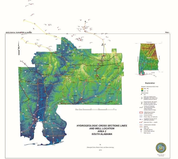
5 Alabama Groundwater Research Statewide Groundwater Assessment Area 2

6 Production Impacts Public Water Supply Ripley Aquifer-South Alabama Large cone of depression in the Ripley Aquifer occurs in Butler County in South Alabama due to production impacts. Efforts are reversing this drawdown
7 Production Impacts Public Water Supply Ripley Aquifer-South Alabama Large cone of depression in the Ripley Aquifer occurs in Butler County in South Alabama due to production impacts. Efforts are reversing this drawdown

8 Saltwater /Freshwater interface impact on water supply
9 Analytical Data Water Well and Aquifer Data Aquifer Maps Well Construction Data Water Quality Isotopes Recharge Rates Water Levels Net Productive Intervals Drawdown Specific Capacity Pumping Rates Groundwater Storage Geologic Structure Structural and Stratigraphic Cross Sections Geochemical Constituents Concentrations
10 Structural and Stratigraphic Cross Sections Net Productive Intervals

11 Generalized Stratigraphy Southeast Alabama Major Aquifers Minor Aquifers
12 Geological Survey of Alabama Groundwater Assessment Program GSA GAP has a large water resource data set including hydrogeologic research, water well records (more than 125,000), and geochemical data dating to the early 1900 s.

13 Assessment Tools Geophysics
14

15 Water Well Geophysical Logs
16 Oil and Gas Board (OGB) has a large data set including well records (more than 17,000). These data are critical to Alabama s water future and will be effectively managed using the GSA RBDMS-ENV (Risk Based Data Management System-Environmental) database. Geological Survey of Alabama Groundwater Assessment Program
17 Geological Survey of Alabama Groundwater Assessment Program GSA RBDMS-ENV database is under construction and will be launched soon on the GSA website. It will include all the water wells records and links to the Oil and Gas Board wells.

18 Oil and Gas Well Geophysical Log

19 Oil and Gas Well Geophysical Logs

20 Cross Sections For each cross-section, a horizontal scale of one inch equals one mile and vertical scale of one inch equals 200 feet was chosen (vertical exaggeration 26.4 x).
21 Cross Sections These cross sections are used to identify: geologic structure aquifers (depth and elevation) and their production intervals planning the exploitation of the aquifers, and determining where deeper aquifers might be located.
22
23
24
25
26 Cross Section B B
27 Cross Section B B
28
29 Cross Section C C
30
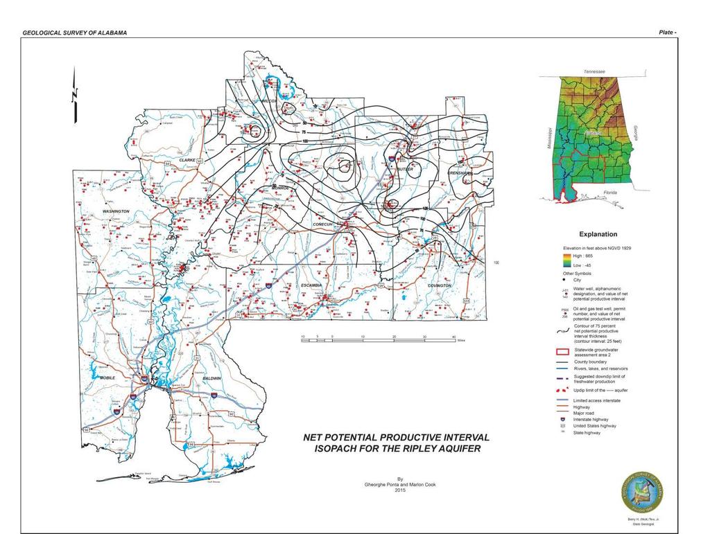
31 Net Potential Productive Interval Map The Net Potential Productive Interval (NPPI) map, is based on the geophysical well logs for delineation of sand and limestone beds and determination of their thicknesses. Measurements of the natural gamma radiation (gamma ray logs) in subsurface sediments, combined with resistivity and spontaneous potential (SP) logs, are the principal means of determining the presence and thicknesses of sand and limestone intervals in formations penetrated by boreholes.
32 Net Potential Productive Interval Mapping GR Resistivity Nanafalia Formation = 74 ft 75%
33 Net Potential Productive Interval Map Thicknesses of the NPPI were plotted on maps and the values were contoured. Data were limited to the net thickness in which the percentage of clean aquifer matrix was analyzed to be greater than 75 percent for the logged interval.
34 Net Potential Productive Interval Map Data generated from NPPI assessments commonly indicate limits of water production in an evaluated aquifer as a combination of net aquifer thickness and water-quality (salinity) estimation from geophysical logs. It should be noted that maps depicting NPPI thicknesses do not always coincide with thicknesses of the geologic formations. For example, it is not uncommon for a geologic formation to thicken southward in the study area, while the net sand/limestone content thins.
35
36
37 Conclusions Abundant ground-water supplies are available in much of Alabama. However, currently developed water sources produced from concentrated areas of withdrawal cannot sustain current production rates or additional development. Therefore, future water source development will require significant scientific research, substantial logistical planning and infrastructure to find adequate sources and to move water where it is needed.
Finding Large Capacity Groundwater Supplies for Irrigation
 Finding Large Capacity Groundwater Supplies for Irrigation December 14, 2012 Presented by: Michael L. Chapman, Jr., PG Irrigation Well Site Evaluation Background Investigation Identify Hydrogeologic Conditions
Assessment of Lake Forest Lake Sediment Trapping Efficiency and Capacity. Marlon R. Cook Groundwater Assessment Program Geological Survey of Alabama
 Assessment of Lake Forest Lake Sediment Trapping Efficiency and Capacity Marlon R. Cook Groundwater Assessment Program Geological Survey of Alabama Impacts of the Lake at Lake Forest on the connectivity
ASSESSMENT OF THE HYDROGEOLOGY AND GROUND- WATER GEOCHEMISTRY OF SOUTHWESTERN ELMORE COUNTY, ALABAMA
 ASSESSMENT OF THE HYDROGEOLOGY AND GROUND- WATER GEOCHEMISTRY OF SOUTHWESTERN ELMORE COUNTY, ALABAMA Outcrop of Paleozoic metamorphic rock on the Coosa River below Jordan Lake Dam GEOLOGICAL SURVEY OF
Land subsidence due to groundwater withdrawal in Hanoi, Vietnam
 Land Subsidence (Proceedings of the Fifth International Symposium on Land Subsidence, The Hague, October 1995). 1AHS Publ. no. 234, 1995. 55 Land subsidence due to groundwater withdrawal in Hanoi, Vietnam
Regional Groundwater Availability Study of the Edwards-Trinity Aquifer in parts of Pecos, Brewster, Jeff Davis and Reeves Counties, Texas
 Regional Groundwater Availability Study of the Edwards-Trinity Aquifer in parts of Pecos, Brewster, Jeff Davis and Reeves Counties, Texas Johnathan R. Bumgarner, P.G. Task Leads: Greg Stanton (Project
PRELIMINARY. Select Geophysical Methods and Groundwater Modeling: Examples from USGS studies. Claudia Faunt and a cast of others
 Select Geophysical Methods and Groundwater Modeling: Examples from USGS studies Claudia Faunt and a cast of others Current Preliminary Studies Stanford Water in the West Groundwater Data Workshop Series:
A method for three-dimensional mapping, merging geologic interpretation, and GIS computation
 A method for three-dimensional mapping, merging geologic interpretation, and GIS computation Soller, David R., U.S. Geological Survey, 908 National Center, Reston, VA 20192 and Richard C. Berg, Illinois
11/22/2010. Groundwater in Unconsolidated Deposits. Alluvial (fluvial) deposits. - consist of gravel, sand, silt and clay
 deposits. - consist of gravel, sand, silt and clay") Groundwater in Unconsolidated Deposits Alluvial (fluvial) deposits - consist of gravel, sand, silt and clay - laid down by physical processes in rivers and flood plains - major sources for water supplies
Groundwater in Unconsolidated Deposits Alluvial (fluvial) deposits - consist of gravel, sand, silt and clay - laid down by physical processes in rivers and flood plains - major sources for water supplies
Wisconsin s Hydrogeology: an overview
 2012 Soil and Water Conservation Society Conference Stevens Point, WI Feb 9, 2012 Wisconsin s Hydrogeology: an overview Ken Bradbury Wisconsin Geological and Natural History Survey University of Wisconsin-Extension
THE MINISTRY OF ENERGY AND ENERGY INDUSTRIES MINERALS DIVISION MINE DESIGN TEMPLATE OPERATOR NAME: OPERATOR ADDRESS: PHONE NUMBER: FACSIMILE:
 THE MINISTRY OF ENERGY AND ENERGY INDUSTRIES MINERALS DIVISION MINE DESIGN TEMPLATE 1.0 GENERAL INFORMATION OPERATOR NAME: OPERATOR ADDRESS: PHONE NUMBER: FACSIMILE: NAME OF CONTACT: CELLULAR PHONE: EMAIL
GAM Run by Ali H. Chowdhury Ph.D., P.G. Texas Water Development Board Groundwater Resources Division (512)
") GAM Run 7-18 by Ali H. Chowdhury Ph.D., P.G. Texas Water Development Board Groundwater Resources Division (512) 936-0834 July 13, 2007 EXECUTIVE SUMMARY The groundwater availability model for the Hill
GAM Run 7-18 by Ali H. Chowdhury Ph.D., P.G. Texas Water Development Board Groundwater Resources Division (512) 936-0834 July 13, 2007 EXECUTIVE SUMMARY The groundwater availability model for the Hill
Surface Processes Focus on Mass Wasting (Chapter 10)
") Surface Processes Focus on Mass Wasting (Chapter 10) 1. What is the distinction between weathering, mass wasting, and erosion? 2. What is the controlling force in mass wasting? What force provides resistance?
Surface Processes Focus on Mass Wasting (Chapter 10) 1. What is the distinction between weathering, mass wasting, and erosion? 2. What is the controlling force in mass wasting? What force provides resistance?
Harvey Thorleifson, Director, Minnesota Geological Survey. Status of geological mapping needed for groundwater protection in Minnesota
 Harvey Thorleifson, Director, Minnesota Geological Survey Status of geological mapping needed for groundwater protection in Minnesota Minnesota is located between the Dakotas and Wisconsin, north of Iowa,
Delineating and Assessing Saline Ground Water Resources
 Delineating and Assessing Saline Ground Water Resources USGS Water Science Centers Arkansas Georgia OklahomA Sulfur water at Chickasaw National Recreation Area Sulphur, Oklahoma Background and Problem
Sequence Stratigraphy of the Upper Cretaceous Niobrara Formation, A Bench, Wattenberg Field, Denver Julesburg Basin, Colorado*
 Sequence Stratigraphy of the Upper Cretaceous Niobrara Formation, A Bench, Wattenberg Field, Denver Julesburg Basin, Colorado* Lisa E. Remington LaChance 1 and Mark C. Robinson 1 Search and Discovery Article
THE MARCELLUS SHALE GAS PLAY Geology, Development, and Water-Resource Impact Mitigation
 THE MARCELLUS SHALE GAS PLAY Geology, Development, and Water-Resource Impact Mitigation John H. Williams New York Water Science Center Troy, New York https://profile.usgs.gov/jhwillia/ Marcellus shale
HYDROGEOLOGIC FRAMEWORK OF LONG ISLAND'S NORTH FORK, SUFFOLK COUNTY, NEW YORK
 HYDROGEOLOGIC FRAMEWORK OF LONG ISLAND'S NORTH FORK, SUFFOLK COUNTY, NEW YORK Christopher E. Schubert 1, Richard E. Bova 2, and Paul E. Misut 1 1 U.S. Geological Survey, 2045 Route 112, Building 4, Coram,
U.S. Department of the Interior Alaska Rural Energy Project
 U.S. Department of the Interior Alaska Rural Energy Project Results from the Coalbed Methane Exploration and Testing Project Wainwright, Alaska 2007-2008 2008 Art Clark U.S. Geological Survey, Denver,
Enhanced Characterization of the Mississippi River Valley Alluvial Aquifer Using Surface Geophysical Methods
 Photo by Shane Stocks, U.S. Geological Survey Enhanced Characterization of the Mississippi River Valley Alluvial Aquifer Using Surface Geophysical Methods Presented by Ryan F. Adams US Geological Survey
Use of Non-Invasive Near-Surface Geophysics for Managing Brine Releases
 Use of Non-Invasive Near-Surface Geophysics for Managing Brine Releases Presented by: Brent W. Barker, Staff Geophysicist Remediation Technologies Symposium 2012 Imagine the result Co-Authors Boyce L.
Hydraulic and Water-Quality Characterization of Fractured-Rock Aquifers Using Borehole Geophysics
 Hydraulic and Water-Quality Characterization of Fractured-Rock Aquifers Using Borehole Geophysics John H. Williams Office of Ground Water Troy, New York Flow in Open Borehole Runkel and others (2003) Ambient
ILLINOIS GROUNDWATER - BEDROCK
 ILLINOIS GROUNDWATER - BEDROCK Northern Illinois Fresh Water Water Supply Shallow Bedrock Aquifers < 500 depth Deep Bedrock Aquifers > 500 depth Southern Illinois Saline water Oil Fracking Coal Waste injection
Chapter 14: Groundwater. Fig 14.5b
 Chapter 14: Groundwater Fig 14.5b OBJECTIVES Recognize that groundwater is a vital source of accessible freshwater. Describe how groundwater forms below the water table. Explain the origin of aquifers,
Geophysical Surveys for Groundwater Modelling of Coastal Golf Courses
 1 Geophysical Surveys for Groundwater Modelling of Coastal Golf Courses C. RICHARD BATES and RUTH ROBINSON Sedimentary Systems Research Group, University of St. Andrews, St. Andrews, Scotland Abstract
THE ROLE OF 3-D GEOLOGIC MODELING AND DATABASE SOLUTIONS IN THE VIRTTAANKANGAS ARTIFICIAL RECHARGE PROJECT, SOUTHWESTERN FINLAND
 THE ROLE OF 3-D GEOLOGIC MODELING AND DATABASE SOLUTIONS IN THE VIRTTAANKANGAS ARTIFICIAL RECHARGE PROJECT, SOUTHWESTERN FINLAND Artimo, A. 1, S. Saraperä 2, and I. Ylander 1 1 Turku Region Water Ltd.,
The Favorability of Florida s Geology to Sinkhole Formation
 Florida Geological Survey The Favorability of Florida s Geology to Sinkhole Formation Clint Kromhout Alan Baker October 24, 2017 Subsidence Report Database Map of Subsidence Incident Reports taken from
Groundwater in Bedrock Aquifers: Development Considerations
 Slide 1 Groundwater in Bedrock Aquifers: Development Considerations Pelham, New Hampshire October 3, 2016 Building Trust. Engineering Success. Slide 2 OUTLINE Background on groundwater in bedrock aquifers
EVALUATION OF THE DOWNWARD MIGRATION OF SALTWATER TO THE UPPER FLORIDAN AQUIFER IN THE SAVANNAH, GEORGIA, AND HILTON HEAD ISLAND, SOUTH CAROLINA, AREA
 EVALUATION OF THE DOWNWARD MIGRATION OF SALTWATER TO THE UPPER FLORIDAN AQUIFER IN THE SAVANNAH, GEORGIA, AND HILTON HEAD ISLAND, SOUTH CAROLINA, AREA Camille Ransom, III 1, James E. Landmeyer 2, W. Robert
Antelope Hills Directionally Drilled Water Well. Theresa Jehn-Dellaport Jehn Water Consultants, Inc.
 Antelope Hills Directionally Drilled Water Well Theresa Jehn-Dellaport Directional Well Applications Deep Bedrock Aquifers Proven Oil field technology Initial Analysis indicates up to 4 times the production
Shallow Karst Aquifer System of the Lake Belt Study Area, Miami-Dade County, Florida, USA EXTENDED ABSTRACT
 Second International Conference on Saltwater Intrusion and Coastal Aquifers Monitoring, Modeling, and Management. Merida, Mexico, March 30 April 2, 2003 Shallow Karst Aquifer System of the Lake Belt Study
Chapter 14. Groundwater
 Chapter 14 Groundwater Importance of groundwater! Groundwater is water found in the pores of soil and sediment, plus narrow fractures in bedrock! Groundwater is the largest reservoir of fresh water that
3D Modelling of the Uppsala Esker
 3D Modelling of the Uppsala Esker Eva Jirner (SGU) Duncan McConnachie (WSP Sweden) 2017-05-31 ISO/TC211 Geographic Information/Geomatics A collabrative effort Orientation 3 Background Uppsala municiaplity
Soils, Hydrogeology, and Aquifer Properties. Philip B. Bedient 2006 Rice University
 Soils, Hydrogeology, and Aquifer Properties Philip B. Bedient 2006 Rice University Charbeneau, 2000. Basin Hydrologic Cycle Global Water Supply Distribution 3% of earth s water is fresh - 97% oceans 1%
KANSAS GEOLOGICAL SURVEY Open File Report LAND SUBSIDENCE KIOWA COUNTY, KANSAS. May 2, 2007
 KANSAS GEOLOGICAL SURVEY Open File Report 2007-22 LAND SUBSIDENCE KIOWA COUNTY, KANSAS Prepared by Michael T. Dealy L.G., Manager, Wichita Operations SITE LOCATION The site was approximately four miles
ambiguity in earth sciences IESO Geophysics Section Eddy hartantyo, Lab Geofisika FMIPA UGM
 ambiguity in earth sciences IESO Geophysics Section Eddy hartantyo, Lab Geofisika FMIPA UGM Pelatihan Tahap II IESO Teknik Geologi UGM Februari 2009 1 Introduction Photos from http://www.eegs.org/whatis/
TAMPA BAY TRIBUTARIES BASIN. Hydrogeological Setting
 TAMPA BAY TRIBUTARIES BASIN Hydrogeological Setting Aquifers within the Tampa Bay Tributaries Basins ground water flow system include the Floridan aquifer system, the intermediate aquifer system, and the
Updating of the Three-dimensional Hydrogeological Model of the Virttaankangas Area, Southwestern Finland
 Updating of the Three-dimensional Hydrogeological Model of the Virttaankangas Area, Southwestern Finland Saraperä S. 1, Artimo A. 2, 1 Department of Geology, FIN-20014, University of Turku, Finland, 2
Ground-Water Exploration in the Worthington Area of Nobles County: Summary of Seismic Data and Recent Test Drilling Results
 Ground-Water Exploration in the Worthington Area of Nobles County: Summary of Seismic Data and Recent Test Drilling Results Jim Berg and Todd Petersen Geophysicists, DNR Waters January 2000 Table of Contents
Presented by: Peter J. Foster. Coauthors: James M. Emery Kenneth C. Hardcastle. Emery & Garrett Groundwater Investigations, LLC
 The Impacts of the Earthquake that Struck near Mineral Virginia on Groundwater Resources in Northern Virginia Presented by: Peter J. Foster Coauthors: James M. Emery Kenneth C. Hardcastle Introduction
Chapter 13. Groundwater
 Chapter 13 Groundwater Introduction Groundwater is all subsurface water that completely fills the pores and other open spaces in rocks, sediments, and soil. Groundwater is responsible for forming beautiful
GROUNDWATER MONITORING DATA 2016 SAMPLING EVENT HARSHAW CHEMICAL COMPANY FUSRAP SITE
 GROUNDWATER MONITORING DATA 2016 SAMPLING EVENT HARSHAW CHEMICAL COMPANY FUSRAP SITE U.S. Army Corps of Engineers Buffalo District Building Strong April 2017 ly Utilized Sites Remedial Action Program The
GROUNDWATER ASSESSMENT OF THE CENTRAL ELMORE WATER AND SEWER AUTHORITY SERVICE AREA, ELMORE COUNTY, ALABAMA
 GROUNDWATER ASSESSMENT OF THE CENTRAL ELMORE WATER AND SEWER AUTHORITY SERVICE AREA, ELMORE COUNTY, ALABAMA By Stephen P. Jennings and Mac McKinney, with GIS assistance by Alana Rogers INTRODUCTION The
Geophysical Exploration in Water Resources Assessment. John Mundell, P.E., L.P.G., P.G. Ryan Brumbaugh, L.P.G. Mundell & Associates, Inc.
 Geophysical Exploration in Water Resources Assessment John Mundell, P.E., L.P.G., P.G. Ryan Brumbaugh, L.P.G. Mundell & Associates, Inc. Presentation Objective Introduce the use of geophysical survey methods
Groundwater Resources of Missouri. Cynthia Brookshire, R. G.
 Groundwater Resources of Missouri Cynthia Brookshire, R. G. GROUNDWATER... Water beneath the Earth s surface within a zone of saturation AQUIFER... A geologic formation or group of formations that are
Recommendations for Injection and Storage Monitoring
 Energy and Environmental Systems Group Institute for Sustainable Energy, Environment and Economy (ISEEE) Recommendations for Injection and Storage Monitoring WABAMUN AREA CO 2 SEQUESTRATION PROJECT (WASP)
Groundwater Sequence Stratigraphy:
 Groundwater Sequence Stratigraphy: A Geology-based Approach for Developing Accurate and Representative Hydrogeologic Conceptual Models for Successful Groundwater Sustainability Plans Rick Cramer, Burns
Groundwater Hydrology
 EXERCISE 12 Groundwater Hydrology INTRODUCTION Groundwater is an important component of the hydrologic cycle. It feeds lakes, rivers, wetlands, and reservoirs; it supplies water for domestic, municipal,
Hydrogeology of East-Central Union County, Northeastern New Mexico
 Hydrogeology of East-Central Union County, Northeastern New Mexico Geoffrey Rawling April 2013 New Mexico Bureau of Geology & Mineral Resources 1 What are the important hydrogeologic issues in Union County?
Chapter 8 Fetter, Applied Hydrology 4 th Edition, Geology of Groundwater Occurrence
 Chapter 8 Fetter, Applied Hydrology 4 th Edition, 2001 Geology of Groundwater Occurrence Figure 8.42. Alluvial Valleys ground-water region. Fetter, Applied Hydrology 4 th Edition, 2001 Fetter, Applied
WWDC Green River Basin Plan II, Groundwater Study (Level I) WSGS USGS WRDS October 23, 2008 Green River Basin (GRB) Basin Advisory Group
 WSGS USGS WRDS October 23, 2008 Green River Basin (GRB) Basin Advisory Group") WWDC Green River Basin Plan II, Groundwater Study (Level I) WSGS USGS WRDS 2007-20092009 October 23, 2008 Green River Basin (GRB) Basin Advisory Group (BAG) Western Wyoming Community College, Rock Springs,
WWDC Green River Basin Plan II, Groundwater Study (Level I) WSGS USGS WRDS 2007-20092009 October 23, 2008 Green River Basin (GRB) Basin Advisory Group (BAG) Western Wyoming Community College, Rock Springs,
Ground Water in the Piedmont and Blue Ridge
 engineering earth's development preserving earth's integrity Engineering Earth s Development Preserving Earth s Integrity Ground Water in the Piedmont and Blue Ridge Jim Renner Acknowledgements Contributors:
Electrical Resistivity Survey for Delineating Seawater Intrusion in a Coastal Aquifer
 Electrical Resistivity Survey for Delineating Seawater Intrusion in a Coastal Aquifer Sung-Ho Song*, Gyu-Sang Lee*, Jin-Sung Kim*, Baekuk Seong*, Young-gyu Kim*, Myung-Ha Woo* and Namsik Park** Abstract
STRUCTURAL, HYDROGEOLOGIC FRAMEWORK, AND TEXTURAL MODEL OF THE RIALTO-COLTON BASIN AND THE CHINO AND NORTH RIVERSIDE AREA.
 STRUCTURAL, HYDROGEOLOGIC FRAMEWORK, AND TEXTURAL MODEL OF THE RIALTO-COLTON BASIN AND THE CHINO AND NORTH RIVERSIDE AREA A Thesis Presented to the faculty of the Department of Geology California State
Sand & Gravel Case Study
 Sand & Gravel Case Study Table of Contents Jim Reed RockWare Incorporated 1/12/06 Table of Contents...1 Table of Figures...1 Creating a Borehole Database...2 Displaying the Boreholes...2 Generating the
Subsurface Maps. K. W. Weissenburger. Isopach. Isochore. Conoco, Inc. Ponca City, Oklahoma, U.S.A.
 Subsurface Maps K. W. Weissenburger Conoco, Inc. Ponca City, Oklahoma, U.S.A. INTRODUCTION Reservoir properties are mapped to promote optimal field development. Subsurface maps dictate well placement and
CO 2 Atlas Assessment of Geological Storage Potential
 CO 2 Atlas Assessment of Geological Storage Potential by M. Cloete 08/04/2010, Gaberone Introduction The aim of a CO2 storage atlas is to identify the availability of geological sites that are both safe
Napa County Comprehensive Groundwater Monitoring Program 2015 Annual Report and CASGEM Update
 Napa County Comprehensive Groundwater Monitoring Program 2015 Annual Report and CASGEM Update April 21, 2016 Watershed Information & Conservation Council By Vicki Kretsinger Grabert Overview Evolving groundwater
Bedrock Characterization Mottolo Pig Farm Superfund Site
 Bedrock Characterization Mottolo Pig Farm Superfund Site Andrew Drew Hoffman, PE NH Department of Environmental Services andrew.hoffman@des.nh.gov 603.271.6778 1 Acknowledgments GZA GeoEnvironmental (lead
Geology 103 Planet Earth (QR II), Laboratory Exercises 1. Groundwater
, Laboratory Exercises 1. Groundwater") Geology 103 Planet Earth (QR II), Laboratory Exercises 1 Student Name: Section: Karst Landform: Groundwater Anyone who has viewed Chinese landscape scroll paintings will recognize that the mountains are
Geology 103 Planet Earth (QR II), Laboratory Exercises 1 Student Name: Section: Karst Landform: Groundwater Anyone who has viewed Chinese landscape scroll paintings will recognize that the mountains are
Napa Valley Groundwater Sustainability: A Basin Analysis Report for the Napa Valley Subbasin
 Napa Valley Groundwater Sustainability: A Basin Analysis Report for the Napa Valley Subbasin A report prepared pursuant to California Water Code Section 10733.6(b)(3) EXECUTIVE SUMMARY (354.4(A)) 1 1.0
Computer Modeling and Surface Geophysics Unravel the Mystery of Salt Water Intrusion on Long Island
 First International Conference on Saltwater Intrusion and Coastal Aquifers Monitoring, Modeling, and Management. Essaouira, Morocco, April 23 25, 2001 Computer Modeling and Surface Geophysics Unravel the
SEASONAL WATER STORAGE AND REPLENISHMENT OF A FRACTURED GRANITE AQUIFER USING ASR WELLS
 SEASONAL WATER STORAGE AND REPLENISHMENT OF A FRACTURED GRANITE AQUIFER USING ASR WELLS Mario R. Lluria; Phillip M. Paski; Gary G. Small HydroSystems, Incorporated Phoenix, Arizona USA Presentation Contents
GOVERNMENT OF NEPAL MINISTRY OF IRRIGATION GROUND WATER RESOURCES DEVELOPMENT BOARD BABARMAHAL, KATHMANDU, NEPAL
 GOVERNMENT OF NEPAL MINISTRY OF IRRIGATION GROUND WATER RESOURCES DEVELOPMENT BOARD BABARMAHAL, KATHMANDU, NEPAL GIS Based Updating of Groundwater Level Siraha District Final Report Submitted to Ground
ENVIRONMENTAL EFFECTS OF GROUNDWATER WITHDRAWAL IN SOUTH NYÍRSÉG
 PhD thesis ENVIRONMENTAL EFFECTS OF GROUNDWATER WITHDRAWAL IN SOUTH NYÍRSÉG János Szanyi Szeged, 2004 ENVIRONMENTAL EFFECTS OF GROUNDWATER WITHDRAWAL IN SOUTH NYÍRSÉG Preliminaries, the aims of the dissertation
MODELING THE SALTWATER INTRUSION PHENOMENON IN COASTAL AQUIFERS - A CASE STUDY IN THE INDUSTRIAL ZONE OF HERAKLEIO IN CRETE
 Global NEST Journal, Vol. 7, No 2, pp 197-203, 2005 Copyright 2005 Global NEST Printed in Greece. All rights reserved MODELING THE SALTWATER INTRUSION PHENOMENON IN COASTAL AQUIFERS - A CASE STUDY IN THE
6.1.6 Sampling, Measurement and Testing. 1) Sampling
 Sampling") 6.1.6 Sampling, Measurement and Testing 1) Sampling In the course of drilling at each borehole, the data of all formations encountered was logged while drilling and a record was made of all variations
6.1.6 Sampling, Measurement and Testing 1) Sampling In the course of drilling at each borehole, the data of all formations encountered was logged while drilling and a record was made of all variations
- Cased-hole geophysical well logs - Airborne geophysics - Seismic data - LiDAR. GeoConvention 2015: New Horizons 1
 Thermal Effects and Quaternary Hydrogeology: Making Good Decisions in a Complex Geologic Setting Timothy Johnsen, Phd, Quaternary Specialist (tjohnsen@matrix-solutions.com) Alex Haluszka, MSc, P.Geol.,
Buried-valley Aquifers: Delineation and Characterization from Reflection Seismic and Core Data at Caledon East, Ontario
 Buried-valley Aquifers: Delineation and Characterization from Reflection Seismic and Core Data at Caledon East, Ontario Russell, H.A.J. 1, S.E. Pullan 1, J.A. Hunter 1, D.R. Sharpe 1, and S. Holysh 2 1
The UK GeoEnergy Test Bed Ceri J Vincent British Geological Survey
 The UK GeoEnergy Test Bed Ceri J Vincent British Geological Survey Thanks to Matthew Hall (GTB Theme Lead for G ERA), Phil Meldrum, Russell Swift, Oliver Kuras, Richard Luckett, Andrew Butcher, Jonathan
CE 394K.3 Term Project Report. 3-D Underground Representation of Barnett Shale, TX
 CE 394K.3 Term Project Report 3-D Underground Representation of Barnett Shale, TX Prepared by Weili Lin Instructed by: Dr. David Maidment Environmental and Water Resources Engineering University of Texas
NEW PRODUCTS AND ADVANCEMENTS IN 3-D MODELLING PROTOCOLS BASED ON STUDIES IN THICK DRIFT AREAS IN ONTARIO, CANADA
 NEW PRODUCTS AND ADVANCEMENTS IN 3-D MODELLING PROTOCOLS BASED ON STUDIES IN THICK DRIFT AREAS IN ONTARIO, CANADA Abigail K. Burt and Andrew F. Bajc Ontario Geological Survey, 933 Ramsey Lake Road, Sudbury,
Ontario Ministry of Northern Development and Mines Submission to the Joint Review Panel Public Hearing Proposed Bruce Deep Geological Repository
 Ontario Ministry of Northern Development and Mines Submission to the Joint Review Panel Public Hearing Proposed Bruce Deep Geological Repository August 27, 2013 Background and Scope June 18, 2013, the
SURFACE GEOLOGY AND LIQUEFACTION SUSCEPTIBILITY IN THE INNER RIO GRANDE VALLEY NEAR ALBUQUERQUE, NEW MEXICO
 SURFACE GEOLOGY AND LIQUEFACTION SUSCEPTIBILITY IN THE INNER RIO GRANDE VALLEY NEAR ALBUQUERQUE, NEW MEXICO Keith I. Kelson, Christopher S. Hitchcock, and Carolyn E. Randolph William Lettis & Associates,
SHAWN NAYLOR. Research Hydrogeologist Center for Geospatial Data Analysis, Indiana Geological Survey
 SHAWN NAYLOR Research Hydrogeologist Center for Geospatial Data Analysis, Indiana Geological Survey Project overview Funded by American Recovery and Reinvestment Act Develop distributed network of databases
MEMORANDUM. Jerry Conrow, Ojai Basin Groundwater Management Agency
 MEMORANDUM TO: FROM: Jerry Conrow, Ojai Basin Groundwater Management Agency Gregory Schnaar, PhD, Stephen J. Cullen, PhD, PG, DATE: August 6, 2014, 2014 SUBJECT: Ojai Basin Groundwater Model - Extended
Report of Preliminary Geotechnical Investigation for Ponds
 Florida Department of TRANSPORTATION Report of Preliminary Geotechnical Investigation for Ponds Malabar Road (SR 514) PD&E Study From East of Babcock Street (SR 507) to US 1 Brevard County, Florida FPID:
Appendix D. Sediment Texture and Other Soil Data
 5 6 7 8 Appendix D. Sediment Texture and Other Soil Data This appendix describes the sediment texture of the aquifer system in the Restoration Area. The contents of this appendix describe the: Importance
Steve Whittaker, Petroleum Technology Research Centre Stephen Bend, University of Regina Ben Rostron, University of Alberta Gavin Jensen, Ministry of
 Steve Whittaker, Petroleum Technology Research Centre Stephen Bend, University of Regina Ben Rostron, University of Alberta Gavin Jensen, Ministry of Energy & Resources Williston Basin Petroleum Conference
 12 10 8 6 4 2 0 40-50 50-60 60-70 70-80 80-90 90-100 Fresh Water What we will cover The Hydrologic Cycle River systems Floods Groundwater Caves and Karst Topography Hot springs Distribution of water in
Geological Mapping using Geophysics
 Geological Mapping using Geophysics Pugin, A.J.M. and T.H. Larson Illinois State Geological Survey, 615 E Peabody Dr., Champaign, IL 61820; E-mail: A.J.M. Pugin at pugin@isgs.uiuc.edu Mapping Techniques.
Airborne Geophysics to Map Groundwater. Bill Brown
 Airborne Geophysics to Map Groundwater Bill Brown bb@skytem.com A 6 borehole represents 1 millionth of an acre Aquifer Materials An aquifer is an underground layer of water bearing permeable rock, rock
EPSS 15. Spring Introduction to Oceanography. Laboratory #1 Maps, Cross-sections, Vertical Exaggeration, Graphs, and Contour Skills 4/7/17
 EPSS 15 Spring 2017 Introduction to Oceanography Laboratory #1 Maps, Cross-sections, Vertical Exaggeration, Graphs, and Contour Skills MAPS Provide valuable interface to explore the geography of the world
APPENDIX 3B OCCURRENCE OF SIGNIFICANT RIVER ALLUVIUM AQUIFERS IN THE PLATEAU REGION
 Plateau Region Water Plan January 2011 APPENDIX 3B OCCURRENCE OF SIGNIFICANT RIVER ALLUVIUM AQUIFERS IN THE PLATEAU REGION Occurrence of Significant River Alluvium Aquifers in the Plateau Region Prepared
A Standardized Digital Well-Record Database for the Glaciated U.S.
 A Standardized Digital Well-Record Database for the Glaciated U.S. Randy Bayless and Les Arihood U.S. Geological Survey, Indiana Water Science Center, Indianapolis, IN Howard Reeves U.S. Geological Survey,
MAPPING AND RESERVOIR CHARACTERIZATION OF GEOLOGIC INTERVALS FOR NGL STORAGE APPLICATIONS
 MAPPING AND RESERVOIR CHARACTERIZATION OF GEOLOGIC INTERVALS FOR NGL STORAGE APPLICATIONS Robin V. Anthony 1, Doug Patchen 2, Jessica Moore 3, Michael Solis 4 1 PA DCNR, Bureau of Topographic & Geologic
Dept. of Earth and Environmental Sciences, University of Waterloo, 200 University Ave W, Waterloo, Ontario, Canada, N2L 3G1 2
 A modelling strategy to develop a regional Quaternary geological model across rural and urban areas and administrative borders using existing geological information M. Ross 1, M. Parent 2, A. Taylor 1
4.11 Groundwater model
 4.11 Groundwater model 4.11 Groundwater model 4.11.1 Introduction and objectives Groundwater models have the potential to make important contributions in the mapping and characterisation of buried valleys.
Training the Next Generation of Geoscientists to Solve Realworld Environmental Problems using Advanced Techniques: Year Two Report
 Illinois State Geological Survey 615 E. Peabody Dr. Champaign, IL 61820 Training the Next Generation of Geoscientists to Solve Realworld Environmental Problems using Advanced Techniques: Year Two Report
BACKGROUND GEOLOGY. Hoaglund 1. Wichita Orogeny to the south (10k 15k uplift) Rapid erosion and deposition of uplifted granitic basement rock ~18,000
 Rapid erosion and deposition of uplifted granitic basement rock ~18,000") POST APPRAISAL OF THE MISSOURIAN HOGSHOOTER HYDROCARBON SYSTEM: IMPLICATIONS FOR FUTURE EXPLOITATION IN THE ANADARKO BASIN STEVE HOAGLUND (GEOLOGIST CHESAPEAKE ENERGY) BACKGROUND GEOLOGY Wichita Orogeny
POST APPRAISAL OF THE MISSOURIAN HOGSHOOTER HYDROCARBON SYSTEM: IMPLICATIONS FOR FUTURE EXPLOITATION IN THE ANADARKO BASIN STEVE HOAGLUND (GEOLOGIST CHESAPEAKE ENERGY) BACKGROUND GEOLOGY Wichita Orogeny
GIS Applications in Groundwater Protection /Term Paper Final Paper
 GIS Applications in Groundwater Protection /Term Paper Final Paper By Humoud W. Al-Utaibi ID #937501 For CRP 514: Introduction to GIS Term 061 13 th Offer Course Instructor: Dr. Baqer Al-Ramadan Date:
Identifying Sensitive Aquifers in Ohio
 State of Ohio Environmental Protection Agency Division of Drinking and Ground Waters Identifying Sensitive Aquifers in Ohio May 2007 Ted Strickland, Governor Chris Korleski, Director Acknowledgments Ohio
Monitoring of In-Situ Chemical Oxidation (ISCO) with Time Series Geophysical Surveys
 with Time Series Geophysical Surveys") Monitoring of In-Situ Chemical Oxidation (ISCO) with Time Series Geophysical Surveys Philip T. Harte, P.G. U.S. Geological Survey ptharte@usgs.gov 603-226-7813 U.S. Department of the Interior U.S. Geological
Monitoring of In-Situ Chemical Oxidation (ISCO) with Time Series Geophysical Surveys Philip T. Harte, P.G. U.S. Geological Survey ptharte@usgs.gov 603-226-7813 U.S. Department of the Interior U.S. Geological
Does the SDCP need inputs from geology?
 The British Geological Survey s Experience and Expertise in Supporting Projects such as the Sirte Depression Connection Project David Ovadia Director of International Kingsley Dunham Centre Keyworth Nottingham
TEMPERATURE GEOTHERMAL SYSTEM *.BY. Roger F. Harrison Salt Lake City, Utah. C; K. Blair
 - * f c * -6 9 -.I. lcal '. DEVELOPMENT AND TESTSNG OF A SMALL MODERATE TEMPERATURE GEOTHERMAL SYSTEM *.BY Roger F. Harrison Terra Tek, Inc. Salt Lake City, Utah C; K. Blair Terra Tek, Inc. - Salt Lake
Aquitard Characterization The Legend of Indiana s Magic Clay Layer. Juliet Port, LPG #2214 July 2014
 Aquitard Characterization The Legend of Indiana s Magic Clay Layer Juliet Port, LPG #2214 July 2014 Topics What is an Aquitard? Why do we care? Review of Indiana glacial geology Conceptual Framework Investigation
Applied Geophysics for Environmental Site Characterization and Remediation
 Applied Geophysics for Environmental Site Characterization and Remediation MSECA Webinar September 24, 2015 John Mundell, P.E., L.P.G. Ryan Brumbaugh, L.P.G. MUNDELL & ASSOCIATES, INC. Webinar Objective
Hydrographic Survey Program Texas Water Development Board. Nathan Leber Holly Holmquist Khan Iqbal Josh Duty Eli Pruitt
 Hydrographic Survey Program Texas Water Development Board Nathan Leber Holly Holmquist Khan Iqbal Josh Duty Eli Pruitt The following presentation is based upon professional research and analysis within
Illinois Drought Update, December 1, 2005 DROUGHT RESPONSE TASK FORCE Illinois State Water Survey, Department of Natural Resources
 Illinois Drought Update, December 1, 2005 DROUGHT RESPONSE TASK FORCE Illinois State Water Survey, Department of Natural Resources For more drought information please go to http://www.sws.uiuc.edu/. SUMMARY.
A surficial. P^HiHI waste disposal site, Bureau County, Illinois. east of the Sheffield low-level radioactive. electrical resistivity survey
 ISGS CONTRACT/GRANT REPORT 1981-6 WATER RESOURCES DIVISION/USGS P^HiHI 100240 557.09773 IL6cr 1981-6 A surficial electrical resistivity survey east of the Sheffield low-level radioactive waste disposal
Hydrogeology and Simulated Effects of Future Water Use and Drought in the North Fork Red River Alluvial Aquifer: Progress Report
 Hydrogeology and Simulated Effects of Future Water Use and Drought in the North Fork Red River Alluvial Aquifer: Progress Report Developed in partnership with the Oklahoma Water Resources Board S. Jerrod