3D Modelling of the Uppsala Esker
|
|
|
- Meredith Sanders
- 5 years ago
- Views:
Transcription
 Duncan")

1 3D Modelling of the Uppsala Esker Eva Jirner (SGU) Duncan McConnachie (WSP Sweden) ISO/TC211 Geographic Information/Geomatics


2 A collabrative effort
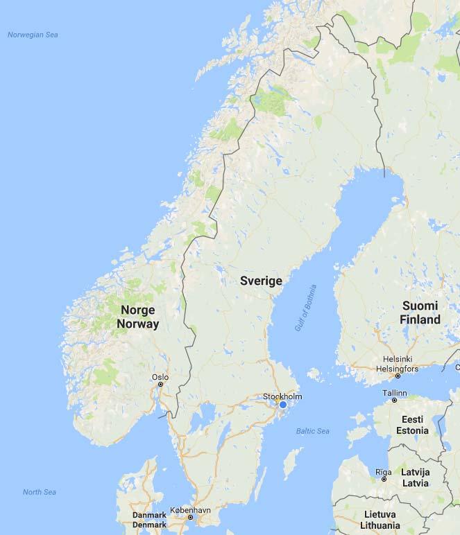


3 Orientation 3


4 Background Uppsala municiaplity = > inhabitants. Model area = part of the esker used for the water supply of Uppsala (294 km 2 ). Fyrisån and Uppsala esker have always been a central part of Uppsalas water supply. In order to increase water supply, infiltration of Fyrisåns water was initiated in the middle of the 1950 s at Tunåsen. Positive result infiltration beds were constructed Infiltrated water is pumped out through a series of wells located 2.1 km south at Galgbacken. Further wells were constructed at Storvad, approx. 1,3 km north of Tunåsen in the early 1960 s. A news infiltration bed was constructed in the 1970 s at Vallskog, approx. 2.5 km north of Storvad. Finally, in order to improve the reliability of the water supply and to soften the water, two new water works were commsioned at Gränby and Bäcklösa ( ). Galgbacken is now a reserve water work. Vallskog Storvad Tunåsen Galgbacken Gränby Bäcklösa
5 Background Uppsala s population is expected to grow rapidly: år 2030 / år 2050 The esker runs through the central parts of the city - highly vulnerable to potential contamination from industry and other activities. Large pressure for development of new housing and industrial areas. Artificial groundwater infiltration from Fyrisån is contributing large amounts of NOM (Natural Organic Material) to the esker (about 100 tons/year). Uppsala Water initiated a strategic project in 2013 titled Funktionsanalys Uppsalaåsen 1. Expected increased water demand 2. Sustainability of artificial infiltration with regards to NOM 3. Address existing water quality problems 4. Risk of contamination of groundwater from existing and planned urban areas
6 Activities completed Collection, analysis and digitalisation of relevant information, rapports, maps, etc. Design and construction of a system for storing and sharing data Field work (drilling, installing new groundwater observation wells, measuring of groundwater levels and temperature, conducting soil and water samples, test pumping and infiltration testing). Water and soil analyses Groundwater modelling and scenario analysis Propose prioritised goals Propose operating strategies and operating instructions Knowledge transfer and capacity building
7 Digital archive/database


8 GIS database

9 Plotting of data
10 3D modelling In order to build a 3D mathematical groundwater model, a 3D geological model is needed which describes the geometry and stratigraphy as a base for assigning hydrological boundaries and properties, such permeability and storage capacity.

11 A 3D model for groundwater modelling 42 km 294 km 2


12 The esker is often covered by clay


13 16% is not under clay


14 Quaternary map+dtm


15 Simplified classes of stratigraphy Fill Organic soil Outwash sand Silt and clay Glacial fluvial sediment Till Bedrock


16 Boreholes


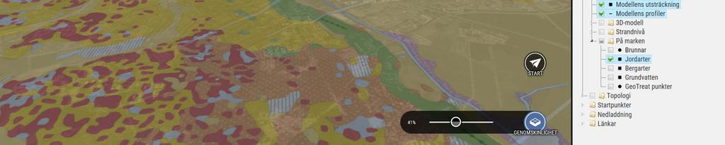
17 Subsurface viewer Mx


18 Work order

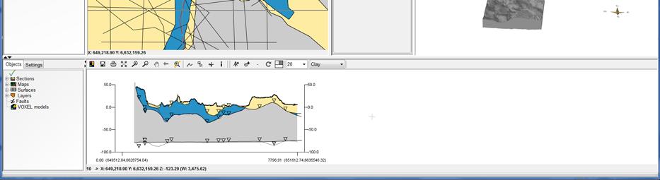
19 Cross section
20 Cross section

21 Cross section in three windows

22 The deepest 160 m!


23 Example

24 The deepest 140 m!


25 A network of profiles

26 The complete block model showing the Quaternary deposits and the Bedrock

27


28 Information from each cross section & the entire model

29


30 3D printing of a generalised model


31 3D-print
32
33 Stratigraphy Fill Organic soil Outwash sand Silt and clay Glacial fluvial sediment Till Bedrock
34 Post-processing av stratigraphy i GIS


35 Export till FeFlow
36 What can a 3D geological modell be used for? Model can be used in physical planning, for example: Groundwater vulnerability assessment Need for protective measures connected to different types of exploitation. Knowledge and understanding of the geological stratification is important to assess the influence on groundwater levels, groundwater flow and groundwater quality from: Underground constructions Removal of confining layers Release of different types of polluting substances etc. Cross-sections, maps and 3D-illustrations can readily be shown and exported from the model and can be used in presentations and as basis for discussion and decision support.


37 Database and modelling Tool for an increased understanding of how the esker functions from a hydrogeological perspective and for testing different scenarios, e.g. location of new infiltration and extraction sites as well as simulating emergency situations. Analysis of contamination risks and different protection strategies and mitigation measures. Operative support to the Uppsala Water keeping a good balance between infiltration and extraction of groundwater.
38 Thank you! sgu.se wsp.com
11/22/2010. Groundwater in Unconsolidated Deposits. Alluvial (fluvial) deposits. - consist of gravel, sand, silt and clay
 deposits. - consist of gravel, sand, silt and clay") Groundwater in Unconsolidated Deposits Alluvial (fluvial) deposits - consist of gravel, sand, silt and clay - laid down by physical processes in rivers and flood plains - major sources for water supplies
Groundwater in Unconsolidated Deposits Alluvial (fluvial) deposits - consist of gravel, sand, silt and clay - laid down by physical processes in rivers and flood plains - major sources for water supplies
AWRA PMAS Engineers Club of Philadelphia. A Geologic Perspective on Stormwater
 AWRA PMAS Engineers Club of Philadelphia A Geologic Perspective on Stormwater Toby J. Kessler, P.G. Hydrogeologist Trevor G. Woodward, P.G. Engineering Geologist September 10, 2014 Gilmore & Associates,
3.0 GEOLOGY AND HYDROGEOLOGY
 3.0 GEOLOGY AND HYDROGEOLOGY 3.1 Methodology The Geological Survey of Ireland (GSI) publication Geology of South Cork was consulted to establish the nature of the bedrock lithology and Quaternary sediments.
THE ROLE OF 3-D GEOLOGIC MODELING AND DATABASE SOLUTIONS IN THE VIRTTAANKANGAS ARTIFICIAL RECHARGE PROJECT, SOUTHWESTERN FINLAND
 THE ROLE OF 3-D GEOLOGIC MODELING AND DATABASE SOLUTIONS IN THE VIRTTAANKANGAS ARTIFICIAL RECHARGE PROJECT, SOUTHWESTERN FINLAND Artimo, A. 1, S. Saraperä 2, and I. Ylander 1 1 Turku Region Water Ltd.,
Hydrogeology in clay till. Timo KESSLER, Knud Erik KLINT, Bertel NILSSON and Poul L. BJERG
 Hydrogeology in clay till Timo KESSLER, Knud Erik KLINT, Bertel NILSSON and Poul L. BJERG motivation Risk assessment of contaminated sites How do contaminants spread in the subsurface? Is geological heterogeneity
Electrical imaging techniques for hydrological and risk assessment studies
 Séminaire IPG le 9 mars 2006 Strasbourg Institute of Geophysics ETH Hoenggerberg CH-8093 Zurich Electrical imaging techniques for hydrological and risk assessment studies Laurent Marescot laurent@aug.ig.erdw.ethz.ch
Geological Survey of Alabama Groundwater Assessment Program
 Geological Survey of Alabama Groundwater Assessment Program Hydrogeologic Characterization and Groundwater Source Development Assessment for Area 2, Southwestern Alabama Gheorghe M. Ponta, Marlon R. Cook,
Groundwater Hydrology
 EXERCISE 12 Groundwater Hydrology INTRODUCTION Groundwater is an important component of the hydrologic cycle. It feeds lakes, rivers, wetlands, and reservoirs; it supplies water for domestic, municipal,
AGENDA ITEM 6 APPENDIX /0151/DET GROUND WATER & SURFACE WATER MANAGEMENT PLAN
 CAIRNGORMS NATIONAL PARK AUTHORITY Planning Committee Agenda Item 6 Appendix 18 12/10/2018 AGENDA ITEM 6 APPENDIX 18 2018/0151/DET GROUND WATER & SURFACE WATER MANAGEMENT PLAN Dalwhinnie Quarry Ground
ASK Network Partnership
 ASK Network Partnership Hugh Barron & Diarmad Campbell, BGS NERC All rights reserved Scottish Water, Shieldhall, 30 August 2013 What is ASK? Accessing Subsurface Knowledge..a knowledge exchange network
Procedure for Determining Near-Surface Pollution Sensitivity
 Procedure for Determining Near-Surface Pollution Sensitivity Minnesota Department of Natural Resources Division of Ecological and Water Resources County Geologic Atlas Program March 2014 Version 2.1 I.
HYDROGEOLOGICAL PROPERTIES OF THE UG2 PYROXENITE AQUIFERS OF THE BUSHVELD COMPLEX
 R. Gebrekristos, P.Cheshire HYDROGEOLOGICAL PROPERTIES OF THE UG2 PYROXENITE AQUIFERS OF THE BUSHVELD COMPLEX R. Gebrekristos Digby Wells Environmental P. Cheshire Groundwater Monitoring Services Abstract
Geophysical Surveys for Groundwater Modelling of Coastal Golf Courses
 1 Geophysical Surveys for Groundwater Modelling of Coastal Golf Courses C. RICHARD BATES and RUTH ROBINSON Sedimentary Systems Research Group, University of St. Andrews, St. Andrews, Scotland Abstract
Chapter 13. Groundwater
 Chapter 13 Groundwater Introduction Groundwater is all subsurface water that completely fills the pores and other open spaces in rocks, sediments, and soil. Groundwater is responsible for forming beautiful
A method for three-dimensional mapping, merging geologic interpretation, and GIS computation
 A method for three-dimensional mapping, merging geologic interpretation, and GIS computation Soller, David R., U.S. Geological Survey, 908 National Center, Reston, VA 20192 and Richard C. Berg, Illinois
STUDY GUIDE FOR CONTENT MASTERY. Movement and Storage of Groundwater
 Groundwater SECTION 10.1 Movement and Storage of Groundwater In your textbook, read about the hydrosphere, precipitation and groundwater, and groundwater storage. Use the following terms to complete the
Land subsidence due to groundwater withdrawal in Hanoi, Vietnam
 Land Subsidence (Proceedings of the Fifth International Symposium on Land Subsidence, The Hague, October 1995). 1AHS Publ. no. 234, 1995. 55 Land subsidence due to groundwater withdrawal in Hanoi, Vietnam
Urban storm water management
 Urban storm water management Cooperation between geologists and land-use planners Philipp Schmidt-Thomé Geological Survey of Finland Background Urban flood modeling has become more topical during 21 st
A national 3D geological model of Denmark: Condensing more than 125 years of geological mapping
 A national 3D geological model of Denmark: Condensing more than 125 years of geological mapping Peter B.E. Sandersen Thomas Vangkilde-Pedersen Geological Survey of Denmark and Greenland Flemming Jørgensen
Finding Large Capacity Groundwater Supplies for Irrigation
 Finding Large Capacity Groundwater Supplies for Irrigation December 14, 2012 Presented by: Michael L. Chapman, Jr., PG Irrigation Well Site Evaluation Background Investigation Identify Hydrogeologic Conditions
Proposed Cemetery Thornhill Road. Tier One Hydrogeological Risk Assessment. Peter Mitchell Associates
 Proposed Cemetery Thornhill Road Tier One Hydrogeological Risk Assessment Peter Mitchell Associates January 2015 Executive Summary This report uses a desk-based risk assessment technique published by the
Hydrogeology of Karst NE Wisconsin. Dr. Maureen A. Muldoon UW-Oshkosh Geology Department
 Hydrogeology of Karst NE Wisconsin Dr. Maureen A. Muldoon UW-Oshkosh Geology Department WI Bedrock Outline Karst Landscapes Existing WQ Data Flow in Karst Aquifers Overview of Silurian Aquifer Water Level
Jim Turenne. Soils on Social Media
 Jim Turenne USDA-NRCS 60 Quaker Lane, Suite 46 Warwick, RI. 02886 401-822-8832 Jim.turenne@ri.usda.gov Soils on Social Media www.twitter.com/soilsne www.fb.com/soilsne www.nesoil.com U.S. Department of
Harvey Thorleifson, Director, Minnesota Geological Survey. Status of geological mapping needed for groundwater protection in Minnesota
 Harvey Thorleifson, Director, Minnesota Geological Survey Status of geological mapping needed for groundwater protection in Minnesota Minnesota is located between the Dakotas and Wisconsin, north of Iowa,
Connecticut's Aquifers
 Page 1 of 5 DEP Search: Connecticut's Aquifers The technical definition of the word "aquifer" is: any geologic formation capable of yielding significant quantities of water to wells. By that definition,
Modeling Uncertainty in the Earth Sciences Jef Caers Stanford University
 Modeling Uncertainty in the Earth Sciences: Introduction Modeling Uncertainty in the Earth Sciences Jef Caers Stanford University What is this book about? Modeling uncertainty in the Earth sciences June
Michigan s Geology and Groundwater
 Michigan s Geology and Groundwater Ralph J. Haefner Deputy Director U.S. Geological Survey Michigan-Ohio Water Science Center Lansing, Michigan Outline About the USGS Geology 101 Michigan s geology Bedrock
SASKATCHEWAN STRATIGRAPHY GLACIAL EXAMPLE BOULDERS IN GLACIAL DEPOSITS
 SASKATCHEWAN STRATIGRAPHY GLACIAL EXAMPLE BOULDERS IN GLACIAL DEPOSITS 51 SASKATCHEWAN STRATIGRAPHY GLACIAL SURFICIAL STRATIFIED DEPOSITS 52 SASKATCHEWAN STRATIGRAPHY GLACIAL EXAMPLE OF SEDIMENT DEPOSITION
Surface Processes Focus on Mass Wasting (Chapter 10)
") Surface Processes Focus on Mass Wasting (Chapter 10) 1. What is the distinction between weathering, mass wasting, and erosion? 2. What is the controlling force in mass wasting? What force provides resistance?
Surface Processes Focus on Mass Wasting (Chapter 10) 1. What is the distinction between weathering, mass wasting, and erosion? 2. What is the controlling force in mass wasting? What force provides resistance?
WATER RESOURCES AND URBANIZATION Vulnerability and Adaptation in the Context of Climate Variability
 WATER RESOURCES AND URBANIZATION Vulnerability and Adaptation in the Context of Climate Variability Krishna Balakrishnan LA 221: Class Project Problem Statement My PhD research focuses on the vulnerability
ENCE 3610 Soil Mechanics. Site Exploration and Characterisation Field Exploration Methods
 ENCE 3610 Soil Mechanics Site Exploration and Characterisation Field Exploration Methods Geotechnical Involvement in Project Phases Planning Design Alternatives Preparation of Detailed Plans Final Design
Updating of the Three-dimensional Hydrogeological Model of the Virttaankangas Area, Southwestern Finland
 Updating of the Three-dimensional Hydrogeological Model of the Virttaankangas Area, Southwestern Finland Saraperä S. 1, Artimo A. 2, 1 Department of Geology, FIN-20014, University of Turku, Finland, 2
DK 1 Sunds WP 5. SUNDS - Groundwater flooding and 3D geological modelling
 SUNDS - Groundwater flooding and 3D geological modelling Sunds overview Timeline and activities 2017 2018 Workshop case at the TopSoil partner meeting i Brügge in september 2017 The Challenges + High groundwater
INTEGRATION OF BOREHOLE INFORMATION AND RESISTIVITY DATA FOR AQUIFER VULNERABILITY
 INTEGRATION OF BOREHOLE INFORMATION AND RESISTIVITY DATA FOR AQUIFER VULNERABILITY ANDERS V. CHRISTIANSEN 1, ESBEN AUKEN 1 AND KURT SØRENSEN 1 1 HydroGeophysics Group, Aarhus University, Finlandsgade 8,
Soils in Minnesota Calcareous Fens
 Soils in Minnesota Calcareous Fens MGWA TECHNICAL WORKSHOP June 18, 2004 George Poch 6/23/2004 1 Introduction Our presentation today is to show What soils are in the Fen areas How they have been mapped
URBAN HYDROLOGY: WATER IN THE CITY OF TSHWANE Plant Sciences Auditorium, University of Pretoria January 2014 URBAN HYDROGEOLOGY
 URBAN HYDROLOGY: WATER IN THE CITY OF TSHWANE Plant Sciences Auditorium, University of Pretoria 23 24 January 2014 URBAN HYDROGEOLOGY MATTHYS A. DIPPENAAR DEPARTMENT GEOLOGY, UNIVERSITY OF PRETORIA HYDROGEOLOGY
J.H. Campbell Generating Facility Pond A - Location Restriction Certification Report
 J.H. Campbell Generating Facility Pond A - Location Restriction Certification Report Pursuant to: 40 CFR 257.60 40 CFR 257.61 40 CFR 257.62 40 CFR 257.63 40 CFR 257.64 Submitted to: Consumers Energy Company
MAPPING GROUNDWATER VULNERABILITY IN SCOTLAND: A NEW APPROACH FOR THE WATER FRAMEWORK DIRECTIVE
 MAPPING GROUNDWATER VULNERABILITY IN SCOTLAND: A NEW APPROACH FOR THE WATER FRAMEWORK DIRECTIVE B E Ó Dochartaigh 1, D F Ball 1, A M MacDonald 1, A Lilly 2, V Fitzsimons 3, M del Rio 1 and C A Auton 1
about GCC
 about GCC Bldg 234, Flat 11, Al Barakat Street, Hail Al Janaubiyah P.O Box: 94, Postal Code: 123, Al Khaudh, Sultante of Oman Fax : +968 24543188 Mobile :+968 96666445 info@gcc-oman.com www.gcc-oman.com
BCGQ Mission Statement. Acquire new geoscientific knowledge in Québec within a sustainable development perspective of our mineral resources.
 BCGQ Mission Statement Acquire new geoscientific knowledge in Québec within a sustainable development perspective of our mineral resources. Financial Resources Natural Resources Fund, Mining Heritage Section
RESISTIVITY IMAGING AND BOREHOLE INVESTIGATION OF THE BANTING AREA AQUIFER, SELANGOR, MALAYSIA. A.N. Ibrahim Z.Z.T. Harith M.N.M.
 JOURNAL OF ENVIRONMENTAL HYDROLOGY The Electronic Journal of the International Association for Environmental Hydrology On the World Wide Web at http://www.hydroweb.com VOLUME 11 2003 RESISTIVITY IMAGING
Soils, Hydrogeology, and Aquifer Properties. Philip B. Bedient 2006 Rice University
 Soils, Hydrogeology, and Aquifer Properties Philip B. Bedient 2006 Rice University Charbeneau, 2000. Basin Hydrologic Cycle Global Water Supply Distribution 3% of earth s water is fresh - 97% oceans 1%
Sand & Gravel Case Study
 Sand & Gravel Case Study Table of Contents Jim Reed RockWare Incorporated 1/12/06 Table of Contents...1 Table of Figures...1 Creating a Borehole Database...2 Displaying the Boreholes...2 Generating the
4.11 Groundwater model
 4.11 Groundwater model 4.11 Groundwater model 4.11.1 Introduction and objectives Groundwater models have the potential to make important contributions in the mapping and characterisation of buried valleys.
Maggie Payne Jim Turenne
 Maggie Payne Jim Turenne USDA-NRCS 60 Quaker Lane, Suite 46 Warwick, RI. 02886 401-822-8832 maggie.payne@ri.usda.gov U.S. Department of Agriculture 1935: Soil Conservation Service (SCS) Natural Resources
Regional groundwater mapping and model
 Regional groundwater mapping and model Boyd, Dwight 1, Steve Holysh 2, and Jeff Pitcher 1 1 Grand River Conservation Authority, Canada; 2 Regional Municipality of Halton, Canada The Grand River forms one
Study program: Geology. Semester I Required subject Code Subject ECTS. Hours per week
 Study program: Geology Semester I 2FI100112 Math 1 8 3+2+2 216 2FP100212 Physics 1 8 3+2+2 216 UGD101312 Computer Science 6 2+2+1 156 1 4 2+1+1 120 2 4 2+1+1 120 : 2FP110112 Basics geology 2FP101212 Fundamentals
How & Where does infiltration work? Summary of Geologic History Constraints/benefits for different geologic units
 June 26, 2007: Low Impact Development 1 Associated Earth Sciences, Inc. Associated Earth Sciences, Inc. Presented by: Matthew A. Miller, PE April 24, 2012 How & Where does infiltration work? Summary of
C) D) 3. Which graph best represents the relationship between soil particle size and the rate at which water infiltrates permeable soil?
 D) 3. Which graph best represents the relationship between soil particle size and the rate at which water infiltrates permeable soil?") 1. Which earth material covering the surface of a landfill would permit the least amount of rainwater to infiltrate the surface? A) silt B) clay C) sand D) pebbles 2. Which graph best represents the relationship
1. Which earth material covering the surface of a landfill would permit the least amount of rainwater to infiltrate the surface? A) silt B) clay C) sand D) pebbles 2. Which graph best represents the relationship
FORENSIC GEOLOGY A CIVIL ACTION
 NAME 89.215 - FORENSIC GEOLOGY A CIVIL ACTION I. Introduction In 1982 a lawsuit was filed on behalf of eight Woburn families by Jan Schlictmann. The suit alleged that serious health effects (childhood
THE DIGITAL TERRAIN MAP LIBRARY: AN EXPLORATIONIST S RESOURCE
 THE DIGITAL TERRAIN MAP LIBRARY: AN EXPLORATIONIST S RESOURCE By I.C.L. Webster, P.J. Desjardins and W.E. Kilby KEYWORDS: digital terrain maps, digital terrain stability maps, surficial geology, GIS, raster
Tampere - City planning, geology and climate change
 Tampere - City planning, geology and climate change 3 rd International BaltCICA Conference Petri Jokinen, City of Tampere 19 th January 2012 City of Tampere in BaltCICA: City of Tampere is located between
GIS Applications in Groundwater Protection /Term Paper Final Paper
 GIS Applications in Groundwater Protection /Term Paper Final Paper By Humoud W. Al-Utaibi ID #937501 For CRP 514: Introduction to GIS Term 061 13 th Offer Course Instructor: Dr. Baqer Al-Ramadan Date:
Final Report on Development of Deep Aquifer Database and Preliminary Deep Aquifer Map
 4 CHAPTER Final Report on Development of Deep Aquifer Database and Preliminary Deep Aquifer Map 31 Chronostragraphic Mapping 4.1 Introduction The analysis of geological logs was conducted during the project
Groundwater Monitoring & Aggregate Operations in the Villeneuve-Calahoo Area. William Gowdy, BSc. P.Geo
 Groundwater Monitoring & Aggregate Operations in the Villeneuve-Calahoo Area William Gowdy, BSc. P.Geo Format of Talk General Background Sand and Gravel Geology & Formation of Sand and Gravel Deposits
COASTAL QUATERNARY GEOLOGY MAPPING FOR NSW: EXAMPLES AND APPLICATIONS
 COASTAL QUATERNARY GEOLOGY MAPPING FOR NSW: EXAMPLES AND APPLICATIONS A Troedson Geological Survey of New South Wales Abstract Detailed geological mapping of the coastal plains of regional NSW was undertaken
Evaluation of Subsurface Formation of Pabna District, Bangladesh
 IOSR Journal of Applied Geology and Geophysics (IOSR-JAGG) e-issn: 2321 0990, p-issn: 2321 0982.Volume 1, Issue 4 (Sep. Oct. 2013), PP 30-36 Evaluation of Subsurface Formation of Pabna District, Bangladesh
Andrew Lee BEng (Hons) CEng MIStructE FGS FPWS
 CEng MIStructE FGS FPWS") Jim Twaddle BSc (Hons) FGS Andrew Lee BEng (Hons) CEng MIStructE FGS FPWS 22 January 2010 ME50231/RE001 !! "# # $ " %! &' ( "# # $ ) # ' %! "# # $ # "# # $ * + # "# # $ "! # "# # $, # "# # $! -( +.!!/
Jim Twaddle BSc (Hons) FGS Andrew Lee BEng (Hons) CEng MIStructE FGS FPWS 22 January 2010 ME50231/RE001 !! "# # $ " %! &' ( "# # $ ) # ' %! "# # $ # "# # $ * + # "# # $ "! # "# # $, # "# # $! -( +.!!/
Comparison of CPT Based Liquefaction Potential and Shear Wave Velocity Maps by Using 3-Dimensional GIS
 Comparison of CPT Based Liquefaction Potential and Shear Wave Velocity Maps by Using 3-Dimensional GIS Muammer Tün, Uğur Avdan, Metin Altan, Can Ayday Anadolu University, Satellite and Space Sciences Research
Advancing Geoscientific Capability. Geological Survey of Finland
 Advancing Geoscientific Capability Geological Survey of Finland GTK in brief The Geological Survey of Finland (GTK) is one of the largest European centres of excellence in assessment, research and the
Appendix D. Sediment Texture and Other Soil Data
 5 6 7 8 Appendix D. Sediment Texture and Other Soil Data This appendix describes the sediment texture of the aquifer system in the Restoration Area. The contents of this appendix describe the: Importance
Mark S. Nordberg Geology and Groundwater Investigations Section North Central Region Office California Department of Water Resources
 Mark S. Nordberg Geology and Groundwater Investigations Section North Central Region Office California Department of Water Resources Ukiah Drought Workshop July 29, 2009 Groundwater 101 Groundwater is
 12 10 8 6 4 2 0 40-50 50-60 60-70 70-80 80-90 90-100 Fresh Water What we will cover The Hydrologic Cycle River systems Floods Groundwater Caves and Karst Topography Hot springs Distribution of water in
Integrated GIS based approach in mapping the groundwater potential zones in Kota Kinabalu, Sabah, Malaysia
 Integrated GIS based approach in mapping the groundwater potential zones in Kota Kinabalu, Sabah, Malaysia Zulherry Isnain and Juhari Mat Akhir Faculty of Science and Natural Resources, Universiti Malaysia
QUANTIFYING CORRELATION IN THREE-DIMENSIONAL GEOLOGIC MAPPING OF GLACIAL DRIFT
 QUANTIFYING CORRELATION IN THREE-DIMENSIONAL GEOLOGIC MAPPING OF GLACIAL DRIFT John J. Quinn 1 and Howard D Moores 2 1 Argonne National Laboratory, Argonne, IL, USA quinnj@anl.gov 2 Department of Geosciences,
Geology and New England Landscapes
 Geology and New England Landscapes Jim Turenne, CPSS USDA-NRCS Warwick, RI. http://nesoil.com Why Geology? Provides the big picture of site conditions. Major part of soil formation (parent material and
Groundwater Sequence Stratigraphy:
 Groundwater Sequence Stratigraphy: A Geology-based Approach for Developing Accurate and Representative Hydrogeologic Conceptual Models for Successful Groundwater Sustainability Plans Rick Cramer, Burns
Evidence for distribution and thickness of Athens Sub-episode and older sediments in Ottawa County, Michigan
 Evidence for distribution and thickness of Athens Sub-episode and older sediments in Ottawa County, Michigan Patrick M. Colgan Department of Geology Grand Valley State University With thanks to Al Kehew
Tuesday 6 June 2017 Afternoon
 Oxford Cambridge and RSA Tuesday 6 June 2017 Afternoon A2 GCE GEOLOGY F794/01 Environmental Geology *6783378785* Candidates answer on the Question Paper. OCR supplied materials: None Other materials required:
UNIT 4: Earth Science Chapter 21: Earth s Changing Surface (pages )
") CORNELL NOTES Directions: You must create a minimum of 5 questions in this column per page (average). Use these to study your notes and prepare for tests and quizzes. Notes will be turned in to your teacher
CORNELL NOTES Directions: You must create a minimum of 5 questions in this column per page (average). Use these to study your notes and prepare for tests and quizzes. Notes will be turned in to your teacher
Towards Seamless Interactions Between Geologic Models and Hydrogeologic Applications
 Towards Seamless Interactions Between Geologic Models and Hydrogeologic Applications Ross, M. 1, M. Parent 2, R. Martel 1, and R. Lefebvre 1 1 Institut National de la Recherche Scientifique (INRS-ETE),
GEOL.3250 Geology for Engineers Glacial Geology
 GEOL.3250 Geology for Engineers Glacial Geology NAME Part I: Continental Glaciation Continental glaciers are large ice sheets that cover substantial portions of the land area. In the region of accumulation
Groundwater Sensitivity Regions of Kentucky
 Groundwater Sensitivity Regions of Kentucky by Kentucky Department for Environmental Protection Division of Water Groundwater Branch 1994 Interpreted by Joseph A. Ray James S. Webb Phillip W. O'dell Scale
Geo-hazard Potential Mapping Using GIS and Artificial Intelligence
 Geo-hazard Potential Mapping Using GIS and Artificial Intelligence Theoretical Background and Uses Case from Namibia Andreas Knobloch 1, Dr Andreas Barth 1, Ellen Dickmayer 1, Israel Hasheela 2, Andreas
Your web browser (Safari 7) is out of date. For more security, comfort and the best experience on this site: Update your browser Ignore
 is out of date. For more security, comfort and the best experience on this site: Update your browser Ignore") Your web browser (Safari 7) is out of date. For more security, comfort and the best experience on this site: Update your browser Ignore BEDRO CK For the complete encyclopedic entry with media resources,
Your web browser (Safari 7) is out of date. For more security, comfort and the best experience on this site: Update your browser Ignore BEDRO CK For the complete encyclopedic entry with media resources,
WATER ON AND UNDER GROUND. Objectives. The Hydrologic Cycle
 WATER ON AND UNDER GROUND Objectives Define and describe the hydrologic cycle. Identify the basic characteristics of streams. Define drainage basin. Describe how floods occur and what factors may make
How Can We Sustain Groundwater Quality in Karst and Fracturedcarbonate. Maureen A. Muldoon Geology Department Univ. Of Wisconsin-Oshkosh
 How Can We Sustain Groundwater Quality in Karst and Fracturedcarbonate Aquifers? Maureen A. Muldoon Geology Department Univ. Of Wisconsin-Oshkosh The Question Karst and fracturedcarbonates form productive,
THE GEOTECHNICAL MAPS FOR BEARING CAPACITY BY USING GIS AND QUALITY OF GROUND WATER FOR AL- IMAM DISTRICT (BABIL - IRAQ)
") International Journal of Civil Engineering and Technology (IJCIET) Volume 6, Issue 10, Oct 2015, pp. 176-184, Article ID: IJCIET_06_10_015 Available online at http://www.iaeme.com/ijciet/issues.asp?jtype=ijciet&vtype=6&itype=10
International Journal of Civil Engineering and Technology (IJCIET) Volume 6, Issue 10, Oct 2015, pp. 176-184, Article ID: IJCIET_06_10_015 Available online at http://www.iaeme.com/ijciet/issues.asp?jtype=ijciet&vtype=6&itype=10
A model of the Ipswich Urban area, geological mapping in 3D.
 A model of the Ipswich Urban area, geological mapping in 3D. Steve Mathers British Geological Survey, Keyworth, Nottingham E-mail sjma@bgs.ac.uk Background Over the last ten years the British Geological
PHASE 1 STUDIES UPDATE EROSION WORKING GROUP
 PHASE 1 STUDIES UPDATE EROSION WORKING GROUP Presented By MICHAEL WOLFF, PG Erosion Study Area Manager West Valley Demonstration Project Quarterly Public Meeting February 24, 2016 OUTLINE Study 1 Terrain
The Hydrologic Cycle STREAM SYSTEMS. Earth s Water and the Hydrologic Cycle. The Hydrologic Cycle. Hydrologic Cycle
 STREAM SYSTEMS Earth Science: Chapter 5 Reading pages 114-124 The Hydrologic Cycle Oceans not filling up Evaporation = precipitation System is balanced Earth s Water and the Hydrologic Cycle Earth s Water
Wisconsin s Hydrogeology: an overview
 2012 Soil and Water Conservation Society Conference Stevens Point, WI Feb 9, 2012 Wisconsin s Hydrogeology: an overview Ken Bradbury Wisconsin Geological and Natural History Survey University of Wisconsin-Extension
APPLICATION OF ELECTRICAL RESISTIVITY TOMOGRAPHY FOR SAND UNDERWATER EXTRACTION
 International Scientific Conference GEOBALCANICA 2018 APPLICATION OF ELECTRICAL RESISTIVITY TOMOGRAPHY FOR SAND UNDERWATER EXTRACTION Maya Grigorova Ivaylo Koprev University of Mining and Geology St. Ivan
- Cased-hole geophysical well logs - Airborne geophysics - Seismic data - LiDAR. GeoConvention 2015: New Horizons 1
 Thermal Effects and Quaternary Hydrogeology: Making Good Decisions in a Complex Geologic Setting Timothy Johnsen, Phd, Quaternary Specialist (tjohnsen@matrix-solutions.com) Alex Haluszka, MSc, P.Geol.,
QUATERNARY SEQUENCE GRID-BASED HYDROSTRATIGRAPHIC 3D MODELLING BY THE RELATIVE METHOD, CHÂTEAUGUAY RIVER WATERSHED, QUEBEC
 QUAERNARY SEQUENCE GRID-BASED HYDROSRAIGRAPHIC 3D MODELLING BY HE RELAIVE MEHOD, CHÂEAUGUAY RIVER WAERSHED, QUEBEC ommy remblay 1, Miroslav Nastev 2, Michel Lamothe 1 1 UQAM, Département des Sciences de
Section 5 Source Water Protection
 2017 WSP UPDATE Section 5 Source Water Protection As written in WAC 246-290-135, -668, and -690, Group A water systems are required to have source water protection. Source water protection is accomplished
WaterTech 2017 April 4, 2017
 Haskayne Master Drainage Plan: Hydraulic Relationships Between Groundwater Flow Systems and the Bearspaw Reservoir and Potential for Stormwater Disposal, City of Calgary WaterTech 2017 April 4, 2017 Project
Differentiation of chloride source using stable chlorine isotopes
 Differentiation of chloride source using stable chlorine isotopes RemTech 2009 Banff, Alberta October 14-16 2009 Dr. Alec Blyth and Tom Anthony 1 1 currently City of Calgary Background: DOW Chemical Canada
Site Investigation and Landfill Construction I
 Site Investigation and Landfill Construction I Gernot Döberl Vienna University of Technology Institute for Water Quality, Resources and Waste Management Contents Site Investigation Base Liners Base Drainage
Ground-Water Exploration in the Worthington Area of Nobles County: Summary of Seismic Data and Recent Test Drilling Results
 Ground-Water Exploration in the Worthington Area of Nobles County: Summary of Seismic Data and Recent Test Drilling Results Jim Berg and Todd Petersen Geophysicists, DNR Waters January 2000 Table of Contents
INTEGRATED INVESTIGATION TO LOCATE A WASTE DISPOSAL AREA
 INTEGRATED INVESTIGATION TO LOCATE A WASTE DISPOSAL AREA 1 FOR OIL DRILLING PRODUCTS G. APOSTOLOPOULOS 2, K. PAVLOPOULOS 3, C. ANTONIADES 4, I. LOUIS 5 and C. VLACHOU 4 Nestoros 1, 17564 P.Faliron, Athens,
The Geology and Hydrogeology of the Spyhill Area
 The Geology and Hydrogeology of the Spyhill Area Clare North (WorleyParsons Komex) and Martin Ortiz (The City of Calgary) 2-Jul-08 Outline Background Site Location Existing Information New Work Geology
b Blackwell Science Environmental Geology PRINCIPLES AND PRACTICE
 Environmental Geology PRINCIPLES AND PRACTICE Fred G. Bell Department of Geology and Applied Geology University of Natal, Durban, South Africa b Blackwell Science Preface, ix 1 Introduction, 1 1.1 Planning
A Standardized Digital Well-Record Database for the Glaciated U.S.
 A Standardized Digital Well-Record Database for the Glaciated U.S. Randy Bayless and Les Arihood U.S. Geological Survey, Indiana Water Science Center, Indianapolis, IN Howard Reeves U.S. Geological Survey,
NEW PRODUCTS AND ADVANCEMENTS IN 3-D MODELLING PROTOCOLS BASED ON STUDIES IN THICK DRIFT AREAS IN ONTARIO, CANADA
 NEW PRODUCTS AND ADVANCEMENTS IN 3-D MODELLING PROTOCOLS BASED ON STUDIES IN THICK DRIFT AREAS IN ONTARIO, CANADA Abigail K. Burt and Andrew F. Bajc Ontario Geological Survey, 933 Ramsey Lake Road, Sudbury,
Transactions on Information and Communications Technologies vol 18, 1998 WIT Press, ISSN
 STREAM, spatial tools for river basins, environment and analysis of management options Menno Schepel Resource Analysis, Zuiderstraat 110, 2611 SJDelft, the Netherlands; e-mail: menno.schepel@resource.nl
Hawke s Bay Liquefaction Hazard Report - Frequently Asked Questions
 Hawke s Bay Liquefaction Hazard Report - Frequently Asked Questions What is liquefaction? Liquefaction occurs when an earthquake shakes up water-logged sediments. As a result, the soil behaves like a liquid
Big data in the Geoscience: A portal to physical properties Andrew Kingdon, Mark Fellgett and Martin Nayembil
 Big data in the Geoscience: A portal to physical properties Andrew Kingdon, Mark Fellgett and Martin Nayembil British Geological Survey, Keyworth, Nottingham, NG12 5GG, aki@bgs.ac.uk Geosciences were early
GOVERNMENT OF NEPAL MINISTRY OF IRRIGATION GROUND WATER RESOURCES DEVELOPMENT BOARD BABARMAHAL, KATHMANDU, NEPAL
 GOVERNMENT OF NEPAL MINISTRY OF IRRIGATION GROUND WATER RESOURCES DEVELOPMENT BOARD BABARMAHAL, KATHMANDU, NEPAL GIS Based Updating of Groundwater Level Siraha District Final Report Submitted to Ground
Groundwater Level Monitoring of the Quaternary Aquifer at Al Ain City, United Arab Emirates (UAE) using Geophysical Methods
 using Geophysical Methods") Groundwater Level Monitoring of the Quaternary Aquifer at Al Ain City, United Arab Emirates (UAE) using Geophysical Methods Ahmed Murad & Amir Gabr Geology Department UAE University Outlines Introduction
Groundwater Level Monitoring of the Quaternary Aquifer at Al Ain City, United Arab Emirates (UAE) using Geophysical Methods Ahmed Murad & Amir Gabr Geology Department UAE University Outlines Introduction