ASK Network Partnership
|
|
|
- Pearl Curtis
- 5 years ago
- Views:
Transcription


1 ASK Network Partnership Hugh Barron & Diarmad Campbell, BGS NERC All rights reserved Scottish Water, Shieldhall, 30 August 2013

2 What is ASK? Accessing Subsurface Knowledge..a knowledge exchange network


3 ASK Knowledge Exchange ASK Network

4 ASK Network Partnership launched at The Lighthouse, Glasgow in November 2012 George Gastin, Wikimedia Commons, Creative Commons 3.0 license
5 ASK Network Partnership launched at The Lighthouse, Glasgow in November 2012 Attended by representatives from: 20 private sector organisations 12 public sector organisations 4 universities


6 What subsurface knowledge? Superficial model Bedrock model

7 What subsurface knowledge? Coal seam model


8 BGS s Clyde / Glasgow Project Ground conditions Contaminated Land Flooding Sustainable drainage Geothermal resources Contains Ordnance Survey data Crown Copyright and database right

9 Glasgow 3D models synthesis ambitious multi-scalar multi-attributed > 55,000 boreholes.full potential is yet to be realised

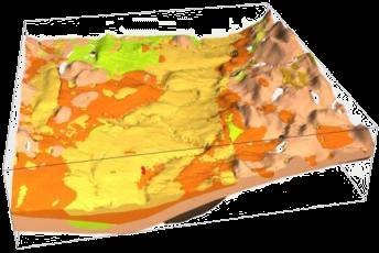


10 The Glasgow experience SI Data BGS 3D models BGS coded logs


11 Future Glasgow virtuous circle 3D model delivery 3D models used for decisionmaking Efficient raw data capture Free flow of data

12 3D geological modelling capture synthesise parameterise deliver


13 Key 3D modelling requirements DTM GI data NEXTMap DTM (Intermap Technologies Inc)


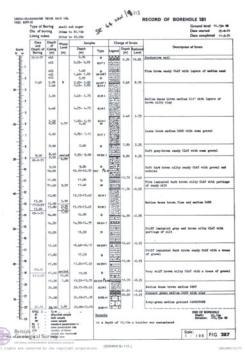
14 Information from boreholes Cores Coded data


15 3D geological modelling GSI3D Gocad - surfaces Gocad - voxels

16 Modelling types central Glasgow Deterministic model Stochastic (voxellated) model


17 Central Glasgow superficial deposits Median depth 3.6 m Depth of borehole (m) 10,342 Boreholes Digital geological maps Contains Ordnance Survey data Crown Copyright and database right


18 GSI3D Modelling process Calculated model Interpret borehole in cross sections
19 Superficial Deposits model Catchment model 85 cross sections 1066 boreholes 41,727 control points Conurbation model 1167 cross sections 11,570 boreholes 326,942 control points


20 Superficial Deposits model


21 Superficial Deposits model Clyde Gateway 3D model 5 km 16 superficial layers, plus artificial ground


22 Engineering property attribution e.g. Strength or permeability texture, grainsize, SPT 5 km Firm to stiff laminated CLAY and SILT

23 Engineering property attribution 5 km Medium to very dense silty SAND & GRAVEL with coarser particles

24 Engineering property attribution 5 km Loose to medium dense silty SAND and SAND
25 Engineering property attribution 5 km Very soft to firm laminated CLAY and SILT some local sand beds

26 Engineering property attribution 5 km Loose to medium dense silty sand and sand

27 Engineering property attribution 5 km Upper part very soft to very stiff CLAY and SILT occasional peat Lower part loose to medium dense SAND and GRAVEL
28 Engineering property attribution Artificial ground 5 km Highly variable, very loose to very dense sand and gravel or very soft to stiff CLAY and SILT, natural or man-made materials


29 Predicting conditions below ground Ground level 2 m depth 5 m depth Attributed by strength

30 3D Engineering geology model predictive tool 5 km but not a substitute for GI! Attributed by strength


31 Engineering data GIS Contains Ordnance Survey data Crown Copyright and database right


32 Bedrock model 85 cross sections 1066 boreholes >106,000 control points 1.39km model depth 794 faults 47 stratigraphic surfaces Mine plans

33 Central Glasgow bedrock model

34 ASK data coverage Contains Ordnance Survey data Crown Copyright and database right

35 ASK data coverage Contains Ordnance Survey data Crown Copyright and database right


36 Model delivery: LithoFrame Viewer


37 Model delivery: GIS layers Clyde Godel Contains Ordnance Survey data Crown Copyright and database right shallow mine workings

38 Model delivery: 3D PDF


39 Model delivery: uncertainty High 10s m in XYZ Low <10m in XYZ
")
40 Model delivery: web (Groundhog)

41 Groundhog cross section

42 Groundhog borehole

43 Groundhog mobile


44 Wealth of data not accessible


45 GSPEC Glasgow SPEcification for data Capture raw digital data AGS compliant Key metadata


46 GSPEC improved knowledge exchange GCC requirement SG e-planning portal Voluntary basis for others

47 GSPEC current status BGS Glasgow City Council MoU signed BGS upload portal under construction Already receiving data manually


48 Groundwater recharge model Calibrated simulated surface flows to observed records TOTAL WATER BALANCE % of Total Inflows Average daily Average Yearly Total Rainfall Ml 100 % mm mm mm Total Evaporation Ml 33 % mm mm mm Total Runoff Ml 39 % mm mm mm Total Recharge Ml 28 % mm mm mm Total Outflows Ml 100 % mm mm Net water Ml 0 % mm mm estimated recharge distribution which feeds into the groundwater model


49 Conceptualisation of groundwater system

50 Conceptualisation of groundwater system Gourock Sand 5 x 10^2 to 5 m/day Bridgeton Sand 5 x 10^2 to 10^-1 m/day Paisley Clay 5 x 10^2 to 5 x 10^-7 m/day simplified conceptual model for groundwater flow in the city created geological units likely to be important to hydraulic flow selected and their extents mapped in 3 dimensions for inclusion into the flow model


51 Conceptualisation of groundwater system elevation data for the top and bottom of the conductive deposits exported into ZOOM

52 Flow model Two valleys identified as the significant conductive deposits in the region Delineated, parameterised and calibrated model monitoring data to be incorporated

53 Flow model Two valleys identified as the significant conductive deposits in the region Delineated, parameterised and calibrated model monitoring data to be incorporated
54 ASK Network Partnership members Private sector Arup Atkins Grontmij UK Jacobs Scottish Coal Co Scottish Power URS Scott Wilson Academic Glasgow Caledonian University University of Strathclyde
55 ASK Network Partnership members Public sector Glasgow City Council Glasgow & Clyde Valley Strategic Planning Authority: East Dunbartonshire Council East Renfrewshire Council Inverclyde Council Renfrewshire Council South Lanarkshire Council West Dunbartonshire Council North Lanarkshire Council Scottish Environment Protection Agency Scottish Water Transport Scotland

56 Glasgow Future Cities Demonstrator

57 Glasgow Future Cities Demonstrator

58 ASK Network: the future increase membership increase data coverage develop web delivery member workshop, late 2013 Red 250k Green 50k Yellow ASK (10k-50k)
59 @AskNetPart
Tools for building and delivering 3D models Perspectives by the BGS
 Tools for building and delivering 3D models Perspectives by the BGS Holger Kessler (on behalf of the 3D community of BGS) Kingsley Dunham Centre Keyworth Nottingham NG12 5GG Tel 0115 936 3100 www.bgs.ac.uk/3dg
3D attributed models for addressing environmental and engineering. geoscience problems in areas of urban regeneration a case study in
 Merritt, J.E. et al., 3D attributed models page 1 10/07/07 3D attributed models for addressing environmental and engineering geoscience problems in areas of urban regeneration a case study in Glasgow,
3D Geoscience models and their delivery to customers
 3D Geoscience models and their delivery to customers Holger Kessler, Mike Lelliott, Dave Bridge, Jon Ford, Hans-Georg Sobisch, Steve Mathers, Simon Price, Jo Merritt, Bruce Napier & Kate Royse GSA Annual
Geological Models for Infrastructure Design:
 Geological Models for Infrastructure Design: Reducing Geotechnical Risk and Supporting Sustainability Alan Keith Turner Emeritus Professor of Geological Engineering CSM Visiting Research Associate - British
Development of a national geophysical log data archive: legacy data as a national asset
 Development of a national geophysical log data archive: legacy data as a national asset Andrew Kingdon & Mark Fellgett Contributions by Helen Bonsor & Diarmad Campbell aki@bgs.ac.uk 0115 936 3415 Preserving
Natural Susceptibility to Coastal Erosion: Methodology and Mapping Summary
 Natural Susceptibility to Coastal Erosion: Methodology and Mapping Summary. Introduction The Flood Risk Management (Scotland) Act 2009 (FRM Act) introduced a coordinated and partnership approach to how
A model of the Ipswich Urban area, geological mapping in 3D.
 A model of the Ipswich Urban area, geological mapping in 3D. Steve Mathers British Geological Survey, Keyworth, Nottingham E-mail sjma@bgs.ac.uk Background Over the last ten years the British Geological
3D geological models and their hydrogeological applications: supporting urban
 3D geological models and their hydrogeological applications: supporting urban development a case study in Glasgow-Clyde, UK S Diarmad G Campbell 1,3 ; Joanne E Merritt 1, Brighid É Ó Dochartaigh 1, Majdi
Impact of the Danube River on the groundwater dynamics in the Kozloduy Lowland
 GEOLOGICA BALCANICA, 46 (2), Sofia, Nov. 2017, pp. 33 39. Impact of the Danube River on the groundwater dynamics in the Kozloduy Lowland Peter Gerginov Geological Institute, Bulgarian Academy of Sciences,
3D Modelling of the Uppsala Esker
 3D Modelling of the Uppsala Esker Eva Jirner (SGU) Duncan McConnachie (WSP Sweden) 2017-05-31 ISO/TC211 Geographic Information/Geomatics A collabrative effort Orientation 3 Background Uppsala municiaplity
Characterisation of Quaternary deposits in West Cumbria using the concept of domains: A case study
 Characterisation of Quaternary deposits in West using the concept of domains: a case study Characterisation of Quaternary deposits in West using the concept of domains: A case study Jon Merritt Quaternary
Collaborative Geotechnical BIM technologies. Carl Grice Software Development Director (Keynetix) Holger Kessler - Team Leader Modelling Systems (BGS)
 Holger Kessler - Team Leader Modelling Systems (BGS)") Collaborative Geotechnical BIM technologies Carl Grice Software Development Director (Keynetix) Holger Kessler - Team Leader Modelling Systems (BGS) 1 2 3 Current Challenges R&D Project Proposed Solution
Collaborative Geotechnical BIM technologies Carl Grice Software Development Director (Keynetix) Holger Kessler - Team Leader Modelling Systems (BGS) 1 2 3 Current Challenges R&D Project Proposed Solution
AGENDA ITEM 6 APPENDIX /0151/DET GROUND WATER & SURFACE WATER MANAGEMENT PLAN
 CAIRNGORMS NATIONAL PARK AUTHORITY Planning Committee Agenda Item 6 Appendix 18 12/10/2018 AGENDA ITEM 6 APPENDIX 18 2018/0151/DET GROUND WATER & SURFACE WATER MANAGEMENT PLAN Dalwhinnie Quarry Ground
Geology Map Extracts. Geology Map Extracts. Report prepared for: Orkney Sustainable Energy Ltd 6 North End Road Stromness Orkney KW16 3AG
 Report prepared for: Orkney Sustainable Energy Ltd 6 North End Road Stromness Orkney KW16 3AG Geology Map Extracts This report is designed for users carrying out preliminary site assessments who require
MAPPING GROUNDWATER VULNERABILITY IN SCOTLAND: A NEW APPROACH FOR THE WATER FRAMEWORK DIRECTIVE
 MAPPING GROUNDWATER VULNERABILITY IN SCOTLAND: A NEW APPROACH FOR THE WATER FRAMEWORK DIRECTIVE B E Ó Dochartaigh 1, D F Ball 1, A M MacDonald 1, A Lilly 2, V Fitzsimons 3, M del Rio 1 and C A Auton 1
Glasgow. TU1206 COST Sub-Urban WG1 Report TU1206-WG Sub-Urban. K. Whitbread, G. Dick & D. Campbell
 Glasgow TU1206-WG1-005 TU1206 COST WG1 Report K. Whitbread, G. Dick & D. Campbell COST TU1206 Report TU1206-WG1-005 Published March 2016 Authors: K. Whitbread, G. Dick and D. Campbell Layout: Guri V. Ganerød
Controls on the Distribution of Drift Filled Hollows in London
 Controls on the Distribution of Drift Filled Hollows in London Stephanie Bricker, Vanessa Banks and Kate Royse Engineering Geology of Scour Features Geol Soc. London, 22 January 2013 Outline 1. Why study
patersongroup Mineral Aggregate Assessment 3119 Carp Road Ottawa, Ontario Prepared For Mr. Greg LeBlanc March 7, 2014 Report: PH2223-REP.
 Geotechnical Engineering Environmental Engineering group Hydrogeology Geological Engineering Archaeological Studies Materials Testing 3119 Carp Road Prepared For Mr. Greg LeBlanc March 7, 2014 Paterson
Big data in the Geoscience: A portal to physical properties Andrew Kingdon, Mark Fellgett and Martin Nayembil
 Big data in the Geoscience: A portal to physical properties Andrew Kingdon, Mark Fellgett and Martin Nayembil British Geological Survey, Keyworth, Nottingham, NG12 5GG, aki@bgs.ac.uk Geosciences were early
What is OneGeology in 2015?
 What is OneGeology in 2015? 25th May 2015 Marko Komac OneGeology Managing Director Presentation Outline Background quick OneGeology history Consortium The vehicle to achieve the goal Current status Where
NEW PRODUCTS AND ADVANCEMENTS IN 3-D MODELLING PROTOCOLS BASED ON STUDIES IN THICK DRIFT AREAS IN ONTARIO, CANADA
 NEW PRODUCTS AND ADVANCEMENTS IN 3-D MODELLING PROTOCOLS BASED ON STUDIES IN THICK DRIFT AREAS IN ONTARIO, CANADA Abigail K. Burt and Andrew F. Bajc Ontario Geological Survey, 933 Ramsey Lake Road, Sudbury,
Chapter 7 Mudflow Analysis
 Chapter 7 Mudflow Analysis 7.0 Introduction This chapter provides information on the potential and magnitude of mud floods and mudflows that may develop in Aspen due to rainfall events, snowmelt, or rain
Land subsidence due to groundwater withdrawal in Hanoi, Vietnam
 Land Subsidence (Proceedings of the Fifth International Symposium on Land Subsidence, The Hague, October 1995). 1AHS Publ. no. 234, 1995. 55 Land subsidence due to groundwater withdrawal in Hanoi, Vietnam
J.H. Campbell Generating Facility Pond A - Location Restriction Certification Report
 J.H. Campbell Generating Facility Pond A - Location Restriction Certification Report Pursuant to: 40 CFR 257.60 40 CFR 257.61 40 CFR 257.62 40 CFR 257.63 40 CFR 257.64 Submitted to: Consumers Energy Company
Soils, Hydrogeology, and Aquifer Properties. Philip B. Bedient 2006 Rice University
 Soils, Hydrogeology, and Aquifer Properties Philip B. Bedient 2006 Rice University Charbeneau, 2000. Basin Hydrologic Cycle Global Water Supply Distribution 3% of earth s water is fresh - 97% oceans 1%
The Assessment of Flood Risk for Proposed Development Sites at Holyport
 The Assessment of Flood Risk for Proposed Development Sites at Holyport Dr Harvey J.E. Rodda FRGS March 2014 Contents Summary... 3 Background... 3 Disclaimer... 3 Location... 4 Topography... 4 Geology...
User Guide: RADON POTENTIAL DATASET - England and Wales
 User Guide: RADON POTENTIAL DATASET - England and Wales This document provides information for users of the joint HPA-BGS RADON POTENTIAL DATASET for England and Wales. 1. Background to joint Health Protection
GIS Applications in Groundwater Protection /Term Paper Final Paper
 GIS Applications in Groundwater Protection /Term Paper Final Paper By Humoud W. Al-Utaibi ID #937501 For CRP 514: Introduction to GIS Term 061 13 th Offer Course Instructor: Dr. Baqer Al-Ramadan Date:
Proposed Cemetery Thornhill Road. Tier One Hydrogeological Risk Assessment. Peter Mitchell Associates
 Proposed Cemetery Thornhill Road Tier One Hydrogeological Risk Assessment Peter Mitchell Associates January 2015 Executive Summary This report uses a desk-based risk assessment technique published by the
Procedure for Determining Near-Surface Pollution Sensitivity
 Procedure for Determining Near-Surface Pollution Sensitivity Minnesota Department of Natural Resources Division of Ecological and Water Resources County Geologic Atlas Program March 2014 Version 2.1 I.
Hydrological Survey of Black Hill, Bedminnie Moss, and Tappethill Moss
 Hydrological Survey of Black Hill, Bedminnie Moss, and Tappethill Moss East Ayrshire Report: Tappethill Hydrological Report r2.docx August 2015 Prepared for: Daisy Whytock, Project Manager, East Ayrshire
Regional groundwater mapping and model
 Regional groundwater mapping and model Boyd, Dwight 1, Steve Holysh 2, and Jeff Pitcher 1 1 Grand River Conservation Authority, Canada; 2 Regional Municipality of Halton, Canada The Grand River forms one
Geological 3D modelling of Quaternary sequences using GSI3D an example of the surroundings of Berne
 armasuisse Geological 3D modelling of Quaternary sequences using GSI3D an example of the surroundings of Berne 9 th Swiss Geoscience Meeting, Zurich 2011 Salomè Michael, Roland Baumberger, Nils Oesterling,
Chapter 7 Mudflow Analysis
 Chapter 7 Mudflow Analysis 7.0 Introduction This chapter provides information on the potential and magnitude of mud floods and mudflows that may develop in Aspen due to rainfall events, snowmelt, or rain
Enhanced Characterization of the Mississippi River Valley Alluvial Aquifer Using Surface Geophysical Methods
 Photo by Shane Stocks, U.S. Geological Survey Enhanced Characterization of the Mississippi River Valley Alluvial Aquifer Using Surface Geophysical Methods Presented by Ryan F. Adams US Geological Survey
Pierce County Department of Planning and Land Services Development Engineering Section
 Page 1 of 7 Pierce County Department of Planning and Land Services Development Engineering Section PROJECT NAME: DATE: APPLICATION NO.: PCDE NO.: LANDSLIDE HAZARD AREA (LHA) GEOLOGICAL ASSESSMENT REPORT
Depth (ft) USCS Soil Description TOPSOIL & FOREST DUFF
 USCS Soil Description TOPSOIL & FOREST DUFF") Test Pit No. TP-6 Location: Latitude 47.543003, Longitude -121.980441 Approximate Ground Surface Elevation: 1,132 feet Depth (ft) USCS Soil Description 0 1.5 1.5 5.0 SM 5.0 8.0 SM Loose to medium dense,
Test Pit No. TP-6 Location: Latitude 47.543003, Longitude -121.980441 Approximate Ground Surface Elevation: 1,132 feet Depth (ft) USCS Soil Description 0 1.5 1.5 5.0 SM 5.0 8.0 SM Loose to medium dense,
SURFACE GEOLOGY AND LIQUEFACTION SUSCEPTIBILITY IN THE INNER RIO GRANDE VALLEY NEAR ALBUQUERQUE, NEW MEXICO
 SURFACE GEOLOGY AND LIQUEFACTION SUSCEPTIBILITY IN THE INNER RIO GRANDE VALLEY NEAR ALBUQUERQUE, NEW MEXICO Keith I. Kelson, Christopher S. Hitchcock, and Carolyn E. Randolph William Lettis & Associates,
PRELIMINARY WORKING DRAFT Work in Progress
 IV. ENVIRONMENTAL IMPACT ANALYSIS H. MINERAL RESOURCES 1.0 INTRODUCTION This section addresses the potential impacts of the Proposed Project on mineral resources (i.e., sand, gravel and petroleum). The
Essentials of Geology, 11e
 Essentials of Geology, 11e Groundwater Chapter 10 Instructor Jennifer Barson Spokane Falls Community College Geology 101 Stanley Hatfield Southwestern Illinois Co Jennifer Cole Northeastern University
Groundwater Hydrology
 EXERCISE 12 Groundwater Hydrology INTRODUCTION Groundwater is an important component of the hydrologic cycle. It feeds lakes, rivers, wetlands, and reservoirs; it supplies water for domestic, municipal,
Land Board, NW Services and SDI Tambet Tiits, FRICS
 Land Board, NW Services and SDI Tambet Tiits, FRICS 07.09.2016 200th anniversary of the Struve Geodetic Arc Friedrich Georg Wilhelm Struve and Carl Friedrich Tenner Struve Geodetic Arc The Struve Geodetic
Groundwater Sequence Stratigraphy:
 Groundwater Sequence Stratigraphy: A Geology-based Approach for Developing Accurate and Representative Hydrogeologic Conceptual Models for Successful Groundwater Sustainability Plans Rick Cramer, Burns
The future of the Lowland Belizean Savannas?.
 The future of the Lowland Belizean Savannas?. Using cluster analysis to explore multivariate spatial patterns in savanna soils PETER FURLEY & SARAH BEADLE UK Belize association 15 th November 2014 Outline
ABP Southampton. Environmental Statement for Port of Southampton: Berth 201/202 Works. Appendix B. Dredge Material Characterisation
 ABP Southampton Environmental Statement for Port of Southampton: Berth 201/202 Works Appendix B Dredge Material Characterisation Appendix B Dredge Material Characterisation Environmental Statement for
TECHNICAL SUPPORT DOCUMENT # 1 COMPARATIVE EVALUATION OF ALTERNATIVE SITES APPENDIX TSD#1-H. Design & Operations Component
 TECHNICAL SUPPORT DOCUMENT # 1 COMPARATIVE EVALUATION OF ALTERNATIVE SITES APPENDIX TSD#1-H Design & Operations Component February 2013 February 2013 Design & Operations Component Appendix TSD#1-H COMPARATIVE
MAIDEN JORC RESOURCE CONFIRMS SIGNIFICANT COAL DEPOSIT AT MARIOLA COAL PROJECT, POLAND
 Level 1, 350 Hay Street, Subiaco, WA 6008 ABN 84 061 219 985 P: +61 8 6365 4519 F: +61 8 9388 6040 E:enquiries@balamara.com.au 15 October 2014 MAIDEN JORC RESOURCE CONFIRMS SIGNIFICANT COAL DEPOSIT AT
3.4 Typical Soil Profiles
 SEI.UoC.0002.11 Figure 4. Streams in central Christchurch as mapped in March 1850, superposed on aerial photography captured on 24 February 2011. Streams digitised from the Black Map of Christchurch (March
Evolution of the conceptual hydrogeologic and ground-water flow model for Las Vegas Valley, Clark County, Nevada
 Evolution of the conceptual hydrogeologic and ground-water flow model for Las Vegas Valley, Clark County, Nevada Geological Society of America Annual Meeting November 14, 2 David J. Donovan Southern Nevada
SASKATCHEWAN STRATIGRAPHY GLACIAL EXAMPLE BOULDERS IN GLACIAL DEPOSITS
 SASKATCHEWAN STRATIGRAPHY GLACIAL EXAMPLE BOULDERS IN GLACIAL DEPOSITS 51 SASKATCHEWAN STRATIGRAPHY GLACIAL SURFICIAL STRATIFIED DEPOSITS 52 SASKATCHEWAN STRATIGRAPHY GLACIAL EXAMPLE OF SEDIMENT DEPOSITION
Ground Water Protection Council 2017 Annual Forum Boston, Massachusetts. Ben Binder (303)
") Ground Water Protection Council 2017 Annual Forum Boston, Massachusetts Protecting Groundwater Sources from Flood Borne Contamination Ben Binder (303) 860-0600 Digital Design Group, Inc. The Problem Houston
Ground Water Protection Council 2017 Annual Forum Boston, Massachusetts Protecting Groundwater Sources from Flood Borne Contamination Ben Binder (303) 860-0600 Digital Design Group, Inc. The Problem Houston
Buried-valley Aquifers: Delineation and Characterization from Reflection Seismic and Core Data at Caledon East, Ontario
 Buried-valley Aquifers: Delineation and Characterization from Reflection Seismic and Core Data at Caledon East, Ontario Russell, H.A.J. 1, S.E. Pullan 1, J.A. Hunter 1, D.R. Sharpe 1, and S. Holysh 2 1
IAEA SAFETY STANDARDS Geotechnical Aspects of Site Evaluation and Foundations in NPPs, NS-G-3.6
 IAEA SAFETY STANDARDS Geotechnical Aspects of Site Evaluation and Foundations in NPPs, NS-G-3.6 Regional Workshop on Volcanic, Seismic, and Tsunami Hazard Assessment Related to NPP Siting Activities and
The Seattle-area geologic mapping project and the geologic framework of Seattle
 The Seattle-area geologic mapping project and the geologic framework of Seattle Troost, K.G., D.B. Booth, S.A. Shimel, and M.A. O Neal, Univ. of Washington, Seattle 98195 Introduction The Puget Lowland
Michigan s Geology and Groundwater
 Michigan s Geology and Groundwater Ralph J. Haefner Deputy Director U.S. Geological Survey Michigan-Ohio Water Science Center Lansing, Michigan Outline About the USGS Geology 101 Michigan s geology Bedrock
Monday 2 June 2014 Morning
 Monday 2 June 2014 Morning A2 GCE GEOLOGY F794/01 Environmental Geology *3076922876* Candidates answer on the Question Paper. OCR supplied materials: None Other materials required: Electronic calculator
National Adaptation Geo-information System (NAGiS) project in Hungary
 project in Hungary") National Adaptation Geo-information System (NAGiS) project in Hungary Mr. Péter Kajner Hungarian Mining and Geological Survey (MBFSZ) National Adaptation Center Department CGE webinar: Geo-information
National Adaptation Geo-information System (NAGiS) project in Hungary Mr. Péter Kajner Hungarian Mining and Geological Survey (MBFSZ) National Adaptation Center Department CGE webinar: Geo-information
Operational water balance model for Siilinjärvi mine
 Operational water balance model for Siilinjärvi mine Vesa Kolhinen, Tiia Vento, Juho Jakkila, Markus Huttunen, Marie Korppoo, Bertel Vehviläinen Finnish Environment Institute (SYKE) Freshwater Centre/Watershed
Appendix G. Summary of Hydrogeologic Conditions and Historical Mining Northwest of the Centro Subarea in the Randsburg, Red Mountain, and Atolia Area
 Appendix G Summary of Hydrogeologic Conditions and Historical Mining Northwest of the Centro Subarea in the Randsburg, Red Mountain, and Atolia Area 1.1 Background This appendix provides a summary of hydrogeologic
Cretaceous, Dakota Formation, Terra Cotta Member South Side of I-70, Salina County, Kansas
 Cretaceous, Dakota Formation, Terra Cotta Member South Side of I-70, Salina County, Kansas Written By: Steven D.J. Baumann G-102010-1A Outcrop looking southeast Photo taken by: Steven Baumann on 10-20-2010
Geology 1:50,000 Maps Legends
 Geology 1:50,000 s Legends MGR WGR WMGR LSGR rtificial Ground and Landslip Made Ground (Undivided) Worked Ground (Undivided) Infilled Ground Landscaped Ground (Undivided) rtificial Deposit Void rtificial
Superficial Geology Map - Slice A. Order Details: Order Number: Customer Reference: National Grid Reference: Slice: Site Area (Ha): Search Buffer (m):
: Search Buffer (m):") Superficial Geology Superficial Deposits are the youngest geological deposits formed during the most recent period of geological time, the Quaternary, which extends back about 1.8 million years from the
Superficial Geology Superficial Deposits are the youngest geological deposits formed during the most recent period of geological time, the Quaternary, which extends back about 1.8 million years from the
Mitford Estate, Morpeth. Phase I Geo-Environmental Assessment. For. Mitford Estates LLP
 Mitford Estate, Morpeth Phase I Geo-Environmental Assessment For Mitford Estates LLP Report Ref Issue Prepared by Date Reviewed by Date 12632 1 A Hampson Feb 15 A Coverdale Feb 15 Client Mitford Estates
The use and applications of the Soilscapes datasets
 The use and applications of the Soilscapes datasets National Soil Resources Institute Timothy S. Farewell Ian G. Truckell Caroline A. Keay Stephen H. Hallett July 2011 The Soilscapes Dataset Edition 1
Integrated GIS based approach in mapping the groundwater potential zones in Kota Kinabalu, Sabah, Malaysia
 Integrated GIS based approach in mapping the groundwater potential zones in Kota Kinabalu, Sabah, Malaysia Zulherry Isnain and Juhari Mat Akhir Faculty of Science and Natural Resources, Universiti Malaysia
4.11 Groundwater model
 4.11 Groundwater model 4.11 Groundwater model 4.11.1 Introduction and objectives Groundwater models have the potential to make important contributions in the mapping and characterisation of buried valleys.
a national geological survey perspective François ROBIDA BRGM (French Geological Survey)
") a national geological survey perspective François ROBIDA BRGM (French Geological Survey) Pre-Conference Seminar on Socio-Economic Value of Geospatial for National and Regional Development 21 August 2017,
a national geological survey perspective François ROBIDA BRGM (French Geological Survey) Pre-Conference Seminar on Socio-Economic Value of Geospatial for National and Regional Development 21 August 2017,
Groundwater Sensitivity Regions of Kentucky
 Groundwater Sensitivity Regions of Kentucky by Kentucky Department for Environmental Protection Division of Water Groundwater Branch 1994 Interpreted by Joseph A. Ray James S. Webb Phillip W. O'dell Scale
Arctic Spatial Data Infrastructure Enabling Access to Arctic Location-Based Information
 Arctic Spatial Data Infrastructure Enabling Access to Arctic Location-Based Information Arctic SDI Side Event Co-Chairs: Arvo Kokkonen Arctic SDI Board Chair & Director General, National Land Survey of
ENCE 3610 Soil Mechanics. Site Exploration and Characterisation Field Exploration Methods
 ENCE 3610 Soil Mechanics Site Exploration and Characterisation Field Exploration Methods Geotechnical Involvement in Project Phases Planning Design Alternatives Preparation of Detailed Plans Final Design
Water Framework Directive. Groundwater Monitoring Programme. Site Information. Drum Bingahamstown
 Water Framework Directive Groundwater Monitoring Programme Site Information Drum Bingahamstown ImagePath1: Drum Bingahamstown\IE_WE_G_16_ 1_a_Spring.jpg Drum Binghamstown is a spring that is used for a
PRELIMINARY. Select Geophysical Methods and Groundwater Modeling: Examples from USGS studies. Claudia Faunt and a cast of others
 Select Geophysical Methods and Groundwater Modeling: Examples from USGS studies Claudia Faunt and a cast of others Current Preliminary Studies Stanford Water in the West Groundwater Data Workshop Series:
Which map shows the stream drainage pattern that most likely formed on the surface of this volcano? A) B)
 B)") 1. When snow cover on the land melts, the water will most likely become surface runoff if the land surface is A) frozen B) porous C) grass covered D) unconsolidated gravel Base your answers to questions
1. When snow cover on the land melts, the water will most likely become surface runoff if the land surface is A) frozen B) porous C) grass covered D) unconsolidated gravel Base your answers to questions
COASTAL QUATERNARY GEOLOGY MAPPING FOR NSW: EXAMPLES AND APPLICATIONS
 COASTAL QUATERNARY GEOLOGY MAPPING FOR NSW: EXAMPLES AND APPLICATIONS A Troedson Geological Survey of New South Wales Abstract Detailed geological mapping of the coastal plains of regional NSW was undertaken
Ministry of ICT of I.R.IRAN
 The ECO 8/6 mill km 2 10 Slamic countries ~330 mill people Oil, Gas, Industries,Tourism 2 Issue transformation in last decade Problem solving needs more integrated approach More interaction &complexity
Watershed simulation and forecasting system with a GIS-oriented user interface
 HydroGIS 96: Application of Geographic Information Systems in Hydrology and Water Resources Management (Proceedings of the Vienna Conference, April 1996). IAHS Publ. no. 235, 1996. 493 Watershed simulation
WaterTech 2017 April 4, 2017
 Haskayne Master Drainage Plan: Hydraulic Relationships Between Groundwater Flow Systems and the Bearspaw Reservoir and Potential for Stormwater Disposal, City of Calgary WaterTech 2017 April 4, 2017 Project
Appendix O. Sediment Transport Modelling Technical Memorandum
 Appendix O Sediment Transport Modelling Technical Memorandum w w w. b a i r d. c o m Baird o c e a n s engineering l a k e s design r i v e r s science w a t e r s h e d s construction Final Report Don
Hydro One (Sept 2014) Hydro One (Sept 2014) Hydro One (Sept 2014)
 Hydro One (Sept 2014) Hydro One (Sept 2014)") TABLE 1 WELL CONSTRUCTION DETAILS MOE WWR No Well ID Location Installation Date Status Easting Coordinates Northing Source Elevation Screened Interval Screened Material Borehole Well Stick-up Ground Top
TABLE 1 WELL CONSTRUCTION DETAILS MOE WWR No Well ID Location Installation Date Status Easting Coordinates Northing Source Elevation Screened Interval Screened Material Borehole Well Stick-up Ground Top
A Collective Approach to Spatial Data Management. Scottish Local Government
 A Collective Approach to Spatial Data Management Scottish Local Government Iain McKay Improvement Service @iainwk Slide 1 of 142 Spatial Information Service Context Scottish Local Government is facing:-
Dept. of Earth and Environmental Sciences, University of Waterloo, 200 University Ave W, Waterloo, Ontario, Canada, N2L 3G1 2
 A modelling strategy to develop a regional Quaternary geological model across rural and urban areas and administrative borders using existing geological information M. Ross 1, M. Parent 2, A. Taylor 1
Geoinformation as a basis for the sustainable use of the subsurface. (Northern Germany)
") Geoinformation as a basis for the sustainable use of the subsurface An approach from Lower Saxony (Northern Germany) Jörg Elbracht, Hans Joachim Heineke & Udo Müller Geologic Survey of Lower Saxony Dep.
Geoinformation as a basis for the sustainable use of the subsurface An approach from Lower Saxony (Northern Germany) Jörg Elbracht, Hans Joachim Heineke & Udo Müller Geologic Survey of Lower Saxony Dep.
KANSAS GEOLOGICAL SURVEY Open File Report LAND SUBSIDENCE KIOWA COUNTY, KANSAS. May 2, 2007
 KANSAS GEOLOGICAL SURVEY Open File Report 2007-22 LAND SUBSIDENCE KIOWA COUNTY, KANSAS Prepared by Michael T. Dealy L.G., Manager, Wichita Operations SITE LOCATION The site was approximately four miles
Data Report for White Point Landslide Boring B-12 W.O. E Task Order Solicitation San Pedro District Los Angeles, California
 Data Report for White Point Landslide Boring B-12 W.O. E1907483 Task Order Solicitation 11-087 San Pedro District Los Angeles, California Submitted To: Mr. Christopher F. Johnson, P.E., G.E. City of Los
' International Institute for Land Reclamation and Improvement. 2 Groundwater Investigations. N.A. de Ridder'? 2.1 Introduction. 2.
 2 Groundwater Investigations N.A. de Ridder'? 2.1 Introduction Successful drainage depends largely on a proper diagnosis of the causes of the excess water. For this diagnosis, one must consider: climate,
DK 1 Sunds WP 5. SUNDS - Groundwater flooding and 3D geological modelling
 SUNDS - Groundwater flooding and 3D geological modelling Sunds overview Timeline and activities 2017 2018 Workshop case at the TopSoil partner meeting i Brügge in september 2017 The Challenges + High groundwater
Converse Consultants Geotechnical Engineering, Environmental & Groundwater Science, Inspection & Testing Services
 Converse Consultants Geotechnical Engineering, Environmental & Groundwater Science, Inspection & Testing Services Ms. Rebecca Mitchell Mt. San Antonio College Facilities Planning & Management 1100 North
GPR survey and field work summary in Siilinjärvi mine during July 2014
 GEOLOGICAL SURVEY OF FINLAND Groundwater Espoo 21.6.2016 67/2016 GPR survey and field work summary in Siilinjärvi mine during July 2014 Samrit Luoma, Juha Majaniemi, Tiina Kaipainen, and Antti Pasanen
Project S4: ITALIAN STRONG MOTION DATA BASE. Deliverable # D3. Definition of the standard format to prepare descriptive monographs of ITACA stations
 Agreement INGV-DPC 2007-2009 Project S4: ITALIAN STRONG MOTION DATA BASE Responsibles: Francesca Pacor, INGV Milano Pavia and Roberto Paolucci, Politecnico Milano http://esse4.mi.ingv.it Deliverable #
A method for three-dimensional mapping, merging geologic interpretation, and GIS computation
 A method for three-dimensional mapping, merging geologic interpretation, and GIS computation Soller, David R., U.S. Geological Survey, 908 National Center, Reston, VA 20192 and Richard C. Berg, Illinois
Keeping it real. Adler de Wind talks to the BGS s Katherine Royse* about how the Survey turns its data into products relevant to decision-making.
 Keeping it real Adler de Wind talks to the BGS s Katherine Royse* about how the Survey turns its data into products relevant to decision-making. Many of our society s most important decisions - sustaining
How to Identify and Properly Classify Drill Cuttings
 How to Identify and Properly Classify Drill Cuttings (Creating Useful Borehole Logs) Dave Larson Hydrogeology and Geophysics Section Accurate information about the borehole location and a careful description
AWRA PMAS Engineers Club of Philadelphia. A Geologic Perspective on Stormwater
 AWRA PMAS Engineers Club of Philadelphia A Geologic Perspective on Stormwater Toby J. Kessler, P.G. Hydrogeologist Trevor G. Woodward, P.G. Engineering Geologist September 10, 2014 Gilmore & Associates,
ARCHAEOLOGICAL S E R V I C E S. 1 Beechmount Road, Southampton, Hampshire. Archaeological Watching Brief. by David Platt. Site Code: SOU1649
 T H A M E S V A L L E Y ARCHAEOLOGICAL S E R V I C E S 1 Beechmount Road, Southampton, Hampshire Archaeological Watching Brief by David Platt Site Code: SOU1649 (SU 4188 1616) 1 Beechmount Road, Southampton,
The Canadian Ceoscience Knowledge Network. - A Collaborative Effort for Unified Access to Ceoscience Data
 The Canadian Ceoscience Knowledge Network - A Collaborative Effort for Unified Access to Ceoscience Data The Canadian Geoscience Knowledge Network A Collaborative Effort for Unified Access to Geoscience
Harvey Thorleifson, Director, Minnesota Geological Survey. Status of geological mapping needed for groundwater protection in Minnesota
 Harvey Thorleifson, Director, Minnesota Geological Survey Status of geological mapping needed for groundwater protection in Minnesota Minnesota is located between the Dakotas and Wisconsin, north of Iowa,
DATA REPORT GEOTECHNICAL INVESTIGATION GALVESTON CRUISE TERMINAL 2 GALVESTON, TEXAS
 DATA REPORT GEOTECHNICAL INVESTIGATION GALVESTON CRUISE TERMINAL 2 GALVESTON, TEXAS SUBMITTED TO PORT OF GALVESTON 123 ROSENBERG AVENUE, 8TH FLOOR GALVESTON, TEXAS 77553 BY HVJ ASSOCIATES, INC. HOUSTON,
Chapter 12 Subsurface Exploration
 Page 12 1 Chapter 12 Subsurface Exploration 1. The process of identifying the layers of deposits that underlie a proposed structure and their physical characteristics is generally referred to as (a) subsurface
Technical Memorandum No
 Pajaro River Watershed Study in association with Technical Memorandum No. 1.2.10 Task: Evaluation of Four Watershed Conditions - Sediment To: PRWFPA Staff Working Group Prepared by: Gregory Morris and
11/22/2010. Groundwater in Unconsolidated Deposits. Alluvial (fluvial) deposits. - consist of gravel, sand, silt and clay
 deposits. - consist of gravel, sand, silt and clay") Groundwater in Unconsolidated Deposits Alluvial (fluvial) deposits - consist of gravel, sand, silt and clay - laid down by physical processes in rivers and flood plains - major sources for water supplies
Groundwater in Unconsolidated Deposits Alluvial (fluvial) deposits - consist of gravel, sand, silt and clay - laid down by physical processes in rivers and flood plains - major sources for water supplies