Geoinformation as a basis for the sustainable use of the subsurface. (Northern Germany)
|
|
|
- Charles White
- 5 years ago
- Views:
Transcription
1 Geoinformation as a basis for the sustainable use of the subsurface An approach from Lower Saxony (Northern Germany) Jörg Elbracht, Hans Joachim Heineke & Udo Müller Geologic Survey of Lower Saxony Dep. Soilscience, Geodatabase and Hydrogeology
2 Lower Saxony DK Baltic Sea North Sea NL Lower Saxony PL Lower Saxony - ~ 48,000 km 2 - ~ 8 Mio. habitants Land use -Agriculture 60 % -Forest 20 % -Settlement 12% fundamental structure of geoinformation-systems was coordinated between 16 federal states
3 Geoinformation: Legal framework - Soil protection: - German Soil Protection Act (BBodSchG): running soil-informationsystems by german states - Water protection: - Lower Saxony s Water Management Act: collecting, evaluating and publishing data (groundwater-quantity and -quality) by Water Survey - Mineral-ressources: - German Mining Act: e.g. duty of disclosure about drillings - more legal framework: - European Water Framework Directive - State planning policy (NROG) - Nature conservation (NNatG) - Fertilizer decree SchuVo - Liquid manure decree


4 Sustainable use of the subsurface needs Geoinformation environmental protection regional planning?? agriculture? Geological Survey? Constructing industry? private users drinking-/ groundwater management?? mineral ressouces
5 GeoInformation by NIBIS environmental protection regional planning!! constructing agriculture! industry! NIBIS! private users drinking-/ groundwater management!! mineral ressouces
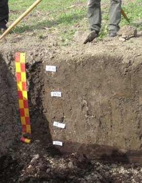
6 - Point data e.g. NIBIS Niedersächsisches Boden Informations System Lower Saxony s Soil Information System - approx drill-logs (> incl. soil-profiles) - approx observation wells - Area database (polygons) - maps in different scales - cross sections - 3D-data - geologic 3D-modells - Methode base e.g. - geothermics - geology (floodvulnerable areas) - soilscience


7 NIBIS : Example Point Data Lower Saxonys Drilling Database (German Mining Law) - Local Water Authorities information drilling- and geophysical data - Lower Saxonys Water Management Department - LBEG Drilling Database
8 NIBIS : Example Area Database I Maps with different themes Mineral ressources Soil science Geology Hydrogeology Geothermal energy Engineering geology Climate/Climate Change and different scales 1: statewide planning/evaluation 1: statewide planning/evaluation 1: planning/evaluation at regional and district level 1: planning/evaluation at regional and district level 1: planning at plot level historical maps planning/evaluation at regional and district level
9 NIBIS : Example Area Database for statewide planning/evaluation Terms of using nearsurface geothermal energy scale 1 : valid testing the effects not valid


10 NIBIS : Example Area Database for planning at regional and district level Position of groundwater surface scale 1 : input data for e.g. - planning protection areas - evaluation of remediation - overhead irrigation planning - nature protection


 - yield")
11 NIBIS : Example Method base I Soil Science technical evaluation for various purposes and at various scales for administration, industry, farmers > 120 modules e.g. - nitrate leaching - leaching of heavy metals Evaluation: Nitrate leaching - leaching of organics - groundwater recharge capacity - potential erosion (wind/water) - yield potential - potential of compaction
12 NIBIS : Example Method base II Soil Science


13 NIBIS : Example Method base III Geothermal Energy Input-data LBEG Input-data user - geology - adress - geothermal features - typ and size of building (heat extraction values) - hydrogeology - borehole data Informations about ground heat collectors and borehole heat exchangers - dimension - cost estimate


14 NIBIS : Example 3D-Models - 3D-data geologic/hydrogeologic 3D-Models (gocad) - virtual boreholes - cross-sections - 3D-pdf - 3D-viewer


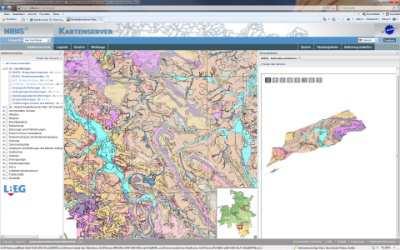
15 NIBIS Mapserver I
16 NIBIS Mapserver II Web Map Services (WMS) for all mapserver-themes e.g. Soilscience data: Geologic data: Engineering-geologic data: Hydrogeologic data: Hydrocarbon-data: Mineral ressources-data: Geothermal Energy:


17 NIBIS New Services NIBIS goes App Geoinformation for smartphones: scan QR-code and use it!
18 NIBIS geoinformations for everyone for every place in lower saxony customers get geoinformation very quick mapserver- and wms-informations are free of charge

19 Thank you very much!
20 NIBIS New Services For a better access to geoinformation: NIBIS Apps Geothermal energy-app: The first of breed
Harvey Thorleifson, Director, Minnesota Geological Survey. Status of geological mapping needed for groundwater protection in Minnesota
 Harvey Thorleifson, Director, Minnesota Geological Survey Status of geological mapping needed for groundwater protection in Minnesota Minnesota is located between the Dakotas and Wisconsin, north of Iowa,
CZECH REPUBLIC PROFILE with focus on the inventory of contaminated sites
 CZECH REPUBLIC PROFILE with focus on the inventory of contaminated sites Pavla Kacabova Ministry of the Environment of the Czech Republic Environmental Damages Department Kacabova_pavla@env.cz PRESENTATION
a national geological survey perspective François ROBIDA BRGM (French Geological Survey)
") a national geological survey perspective François ROBIDA BRGM (French Geological Survey) Pre-Conference Seminar on Socio-Economic Value of Geospatial for National and Regional Development 21 August 2017,
a national geological survey perspective François ROBIDA BRGM (French Geological Survey) Pre-Conference Seminar on Socio-Economic Value of Geospatial for National and Regional Development 21 August 2017,
Digital Datasets Available from the Exploration & Mining Division. Dr. Wayne R. Cox, Senior Geologist, Exploration & Mining Division, DCENR.
 Digital Datasets Available from the Exploration & Mining Division Dr. Wayne R. Cox, Senior Geologist, Exploration & Mining Division, DCENR. Who Are EMD? Line Division of DCENR Small Unit (4 Geological
National Adaptation Geo-information System (NAGiS) project in Hungary
 project in Hungary") National Adaptation Geo-information System (NAGiS) project in Hungary Mr. Péter Kajner Hungarian Mining and Geological Survey (MBFSZ) National Adaptation Center Department CGE webinar: Geo-information
National Adaptation Geo-information System (NAGiS) project in Hungary Mr. Péter Kajner Hungarian Mining and Geological Survey (MBFSZ) National Adaptation Center Department CGE webinar: Geo-information
Advancing Geoscientific Capability. Geological Survey of Finland
 Advancing Geoscientific Capability Geological Survey of Finland GTK in brief The Geological Survey of Finland (GTK) is one of the largest European centres of excellence in assessment, research and the
Geoíndex: a public data dissemination service from the IGC. Geoíndex IGC Team Reporter: Carme Puig
 Geoíndex: a public data dissemination service from the IGC Geoíndex IGC Team Reporter: Carme Puig 2 Brief IGC introduction The IGC was created through the Law 19/2005 of the Catalan Parliament. The IGC
about GCC
 about GCC Bldg 234, Flat 11, Al Barakat Street, Hail Al Janaubiyah P.O Box: 94, Postal Code: 123, Al Khaudh, Sultante of Oman Fax : +968 24543188 Mobile :+968 96666445 info@gcc-oman.com www.gcc-oman.com
Utah UIC Geospatial Integration EIEN Project
 Utah UIC Geospatial Integration EIEN Project ESRI UC, June 2007 Bert Granberg Utah Automated Geographic Reference Center Utah Automated Geographic Reference Center (AGRC) AGRC Responsibilities Facilitate
ArcGIS for INSPIRE. Marten Hogeweg
 ArcGIS for INSPIRE Marten Hogeweg Please Take Our Survey on the App Download the Esri Events app and find your event Select the session you attended Scroll down to find the feedback section Complete answers
Evaluating Sustainability of the Georesources Observation System
 Evaluating Sustainability of the Georesources Observation System Michael Mente Federal Institute for Geosciences and Natural Resources Germany, Hannover GEOSS-CBC Meeting Athens April 27th 28th, 2009 GEOSS-CBC
DEPARTMENT OF GEOLOGY AND MINERAL INDUSTRIES WAYS & MEANS SUBCOMMITTEE ON NATURAL RESOURCES MARCH 2, 2017
 DEPARTMENT OF GEOLOGY AND MINERAL INDUSTRIES WAYS & MEANS SUBCOMMITTEE ON NATURAL RESOURCES MARCH 2, 2017 1 ABOUT DOGAMI AGENCY MISSION, VISION & GOALS 2 Lidar image of a stream network along the Umpqua
GOAL 7 AREAS SUBJECT TO NATURAL DISASTERS AND HAZARDS. To protect life and property from natural disasters and hazards.
 GOAL 7 AREAS SUBJECT TO NATURAL DISASTERS AND HAZARDS A. GOALS: To protect life and property from natural disasters and hazards. B. POLICIES: 1. Floodplains shall be maintained as natural drainage-ways.
Geological information for Europe : Towards a pan-european Geological Data Infrastructure
 Geological information for Europe : Towards a pan-european Geological Data Infrastructure Integrating geoscientific information for EU competitiveness Co-funded by the European Union European societal
Metallic Mineral Exploration in Minnesota: Typical Exploration Activities. Division of Lands and Minerals Minnesota Department of Natural Resources
 Metallic Mineral Exploration in Minnesota: Typical Exploration Activities Division of Lands and Minerals Minnesota Department of Natural Resources Metallic minerals can only be mined economically where
INSPIRE Implementation in Estonia using ArcGIS
 INSPIRE Implementation in Estonia using ArcGIS Sulev Õitspuu Head of Bureau of Geoinfosystems Estonian Land Board 26.09.2016 Population: 1,3 million (69% Estonians) Area: 45,339 km 2 15 counties Estonia
The Governance of Land Use
 The planning system Levels of government and their responsibilities The Governance of Land Use Country fact sheet Germany Germany is a federal country with four levels of government. Below the national
GIS Building Communities beyond National Borders (Building Successful Spatial Data Infrastructures) Nick Land, ESRI Europe
 Nick Land, ESRI Europe") GIS Building Communities beyond National Borders (Building Successful Spatial Data Infrastructures) Nick Land, ESRI Europe UK worst flooding in the last 60 years 350,000 households without drinking water
GIS Building Communities beyond National Borders (Building Successful Spatial Data Infrastructures) Nick Land, ESRI Europe UK worst flooding in the last 60 years 350,000 households without drinking water
Tools for building and delivering 3D models Perspectives by the BGS
 Tools for building and delivering 3D models Perspectives by the BGS Holger Kessler (on behalf of the 3D community of BGS) Kingsley Dunham Centre Keyworth Nottingham NG12 5GG Tel 0115 936 3100 www.bgs.ac.uk/3dg
Vermont Geological Survey s Impact on Public Issues: Geologic Mapping Applied to Hazards and Water
 Vermont Geological Survey s Impact on Public Issues: Geologic Mapping Applied to Hazards and Water Presented by: Marjorie Gale, Vermont State Geologist 1 Jonathan Kim 1, George Springston 2, Colin Dowey
GEO-Government in Baden-Wuerttemberg Strategy on INSPIRE-Coordinates, Nodes and Standards
 INSPIRE Conference 2017: Thinking out of the box GEO-Government in Baden-Wuerttemberg Strategy on INSPIRE-Coordinates, Nodes and Standards Dipl. Ing. Dieter Heß Ministry of Rural Affairs and Consumer Protection
Internet Mapping Framework 1 (IMF) to Common Web Mapping (CWM) Legend Comparison
 to Common Web Mapping (CWM) Legend Comparison") Internet Mapping Framework 1 (IMF) to Common Web Mapping () Legend Comparison IMF Legend Legend Folders Titles (MTO) - Mineral, Placer, Coal Map Viewers.. 3 Coal Grid - Coal Map Viewer. 4 Tenure History
Internet Mapping Framework 1 (IMF) to Common Web Mapping () Legend Comparison IMF Legend Legend Folders Titles (MTO) - Mineral, Placer, Coal Map Viewers.. 3 Coal Grid - Coal Map Viewer. 4 Tenure History
Origin of nitrate pollution in the Walloon part of the Brusselian groundwater body: Crossing a modelling approach with an isotopic analysis.
 Origin of nitrate pollution in the Walloon part of the Brusselian groundwater body: Crossing a modelling approach with an isotopic analysis. Samuel MATTERN, Marnik VANCLOOSTER Introduction Status of the
Together4Water project. Implementing an open-source database to monitor water-related SDG in Tunisia
 Linked Open Data in Agriculture Together4Water project Implementing an open-source database to monitor water-related SDG in Tunisia Ir. Raed Fehri Supervisors: Prof. Marnik Vanclooster Prof. Kim Mens Berlin,
INSPIRE General Introduction & Service Architecture
 INSPIRATION Spatial Data Infrastructure in the Western Balkans INSPIRE General Introduction & Service Architecture 1st National INSPIRATION Workshop Croatia November 21-22, 2012 A multi-countryprojectfunded
Plan4all (econtentplus project)
") Plan4all (econtentplus project) Karel CHARVAT 1, Tomáš MILDORF 2 1 Help service remote sensing, Ltd., Černoleská 1600, 256 01 Benešov u Prahy, Czech Republic charvat@bnhelp.cz 2 Department of Mathematics
Plan4all (econtentplus project) Karel CHARVAT 1, Tomáš MILDORF 2 1 Help service remote sensing, Ltd., Černoleská 1600, 256 01 Benešov u Prahy, Czech Republic charvat@bnhelp.cz 2 Department of Mathematics
Spatially enabling e-government through geo-services
 Spatially enabling e-government through geo-services Mauro Salvemini EUROGI PRESIDENT Professor at Sapienza Università di Roma (IT) 1 About the presentation Few information about Eurogi ; Some essential
ASK Network Partnership
 ASK Network Partnership Hugh Barron & Diarmad Campbell, BGS NERC All rights reserved Scottish Water, Shieldhall, 30 August 2013 What is ASK? Accessing Subsurface Knowledge..a knowledge exchange network
INSPIRE - A Legal framework for environmental and land administration data in Europe
 INSPIRE - A Legal framework for environmental and land administration data in Europe Dr. Markus Seifert Bavarian Administration for Surveying and Cadastre Head of the SDI Office Bavaria Delegate of Germany
Pal NIKOLLI Bashkim IDRIZI Ismail KABASHI Adelajda HALILI THE IMPLEMENTATION OF NATIONAL SPATIAL DATA INFRASTRUCTURE IN ALBANIA
 Pal NIKOLLI Bashkim IDRIZI Ismail KABASHI Adelajda HALILI THE IMPLEMENTATION OF NATIONAL SPATIAL DATA INFRASTRUCTURE IN ALBANIA Overview: Goals of paper Some definitions of SDI NSDI Development NSDI in
Bringing Earth Science to Life
 Bringing Earth Science to Life Earth History Geomorphology Surface Processes Soils Rocks Minerals Tectonics Using Natural Resources Careers www.edgeo.org In partnership with: Students investigate the
Sustainable and Harmonised Development for Smart Cities The Role of Geospatial Reference Data. Peter Creuzer
 Sustainable and Harmonised Development for Smart Cities The Role of Geospatial Reference Data Peter Creuzer 1. Introduction - Smart Cities and Geodata 2. Geodata in Germany 3. Examples 4. Data and Service
Turkey s National SDI Implementation
 Onur PAŞAOĞULLARI Head of Department Turkey s National SDI Implementation Presentation Plan NSDI Background General Directorate of Geographic Information Systems NSDI Project INSPIRE Directive Urban Information
Administration of Mineral Rights
 Administration of Mineral Rights Deborah Archibald Industry, Tourism and Investment, GNWT Malcolm Robb Aboriginal Affairs and Northern Development Canada Business Today How applications are being treated
James Francis Natukunda
 James Francis Natukunda Department of Geological Surveys and Mines Ministry of Energy and Mineral Development, Uganda Regional stakeholders workshop for EARS countries and partners Nairobo, Kenya 15-17
Local Spatial Data Infrastructure, a Solid Base for Sustainable Land Management in Germany
 Local Spatial Data Infrastructure, a Solid Base for Sustainable Land Management in Germany FIG Commission 3 Workshop and Commission 3 Annual Meeting The Empowerment of Local Authorities: Spatial Information
STATE GEOGRAPHIC INFORMATION DATABASE
 STATE GEOGRAPHIC INFORMATION DATABASE Data Information and Knowledge Management STATE GEOGRAPHIC INFORMATION DATABASE EXECUTIVE SUMMARY Utah has developed one of the most comprehensive statewide GIS resources
Increased Liquefaction Vulnerability (ILV) Engineering Assessment
 Engineering Assessment") Increased Liquefaction Vulnerability (ILV) Engineering Assessment Increased Liquefaction Vulnerability (ILV) Engineering Assessment 2 Property details Property address 17 SAMPLE STREET, SAMPLEVILLE, CHRISTCHURCH,
Increased Liquefaction Vulnerability (ILV) Engineering Assessment Increased Liquefaction Vulnerability (ILV) Engineering Assessment 2 Property details Property address 17 SAMPLE STREET, SAMPLEVILLE, CHRISTCHURCH,
INSPIRE Basics. Vlado Cetl European Commission Joint Research Centre. https://ec.europa.eu/jrc/
 INSPIRE Basics Vlado Cetl European Commission Joint Research Centre https://ec.europa.eu/jrc/ Serving society Stimulating innovation Supporting legislation Outline SDI? Why European SDI? INSPIRE Policy
Study program: Geology. Semester I Required subject Code Subject ECTS. Hours per week
 Study program: Geology Semester I 2FI100112 Math 1 8 3+2+2 216 2FP100212 Physics 1 8 3+2+2 216 UGD101312 Computer Science 6 2+2+1 156 1 4 2+1+1 120 2 4 2+1+1 120 : 2FP110112 Basics geology 2FP101212 Fundamentals
Saltwater injection into a fractured aquifer: A density-coupled mass-transport model
 Saltwater injection into a fractured aquifer: A density-coupled mass-transport model Junfeng Luo 1, Martina aus der Beek 2, Joachim Plümacher 2, Sven Seifert 1, Bertram Monninkhoff 1 1 DHI-WASY GmbH, Volmerstr.
Ready for INSPIRE.... connecting worlds. European SDI Service Center
 Ready for INSPIRE Consultancy SOFTWARE T r a i n i n g Solutions... connecting worlds European SDI Service Center Increasing Added Value with INSPIRE and SDI Components INSPIRE In 2007, the European Commission
24.0 Mineral Extraction
 Chapter 24 - Mineral Extraction 24.0 Mineral Extraction 24.1 Introduction Apart from gravel, sand, rock, limestone and salt extraction in relatively small quantities mineral extraction is not a strong
Estonian approach to implementation of INSPIRE directive. Sulev Õitspuu Head of Bureau of Geoinfosystems Estonian Land Board
 Estonian approach to implementation of INSPIRE directive Sulev Õitspuu Head of Bureau of Geoinfosystems Estonian Land Board 13.06.2016 Contents - INSPIRE coordination in Estonia - INSPIRE implementation
Global Geospatial Information Management Country Report Finland. Submitted by Director General Jarmo Ratia, National Land Survey
 Global Geospatial Information Management Country Report Finland Submitted by Director General Jarmo Ratia, National Land Survey Global Geospatial Information Management Country Report Finland Background
Dept. of Earth and Environmental Sciences, University of Waterloo, 200 University Ave W, Waterloo, Ontario, Canada, N2L 3G1 2
 A modelling strategy to develop a regional Quaternary geological model across rural and urban areas and administrative borders using existing geological information M. Ross 1, M. Parent 2, A. Taylor 1
IAEA SAFETY STANDARDS Geotechnical Aspects of Site Evaluation and Foundations in NPPs, NS-G-3.6
 IAEA SAFETY STANDARDS Geotechnical Aspects of Site Evaluation and Foundations in NPPs, NS-G-3.6 Regional Workshop on Volcanic, Seismic, and Tsunami Hazard Assessment Related to NPP Siting Activities and
Maritime Spatial Planning in Germany and Mecklenburg-Vorpommern
 Integrated Sea Use Planning Followings the Ecosystem Approach 2.10.08 Maritime Spatial Planning in Germany and Mecklenburg-Vorpommern by Helmuth von Nicolai Spatial Planning Department Ministry of Transport,
Outline. What is MapPlace? MapPlace Toolbar & PopUp Menu. Geology Themes 1:5M 1:1M BCGS 1:250,000. Terranes
 Outline BRITISH COLUMBIA Overview and Explore MapPlace Website Data Delivery & Map Themes Data Sources & Updates Feature Topics New Data & Maps New MINFILE Online Exploration Assistant with Image Analysis
The ESPON Programme and the use of spatial data on the European level
 The ESPON Programme and the use of spatial data on the European level Plan4Business project ISOCARP Brussels Liaison Office 29 November 2013 Marjan van Herwijnen Project Expert - ESPON Coordination Unit
Information System for Large Projects in Underground Space Development
 Information System for Large Projects in Underground Space Development Prof. Dr.-Ing. Monika Jarosch University of Siegen, Germany Prof. Dr.-Ing. O.K. Postolskaya Prof. Dr.-Ing. S. Yufin Dipl.-Ing. A.V.
NATURAL RESOURCES CANADA
 Clean Growth Program Geological Survey of Canada (Calgary) Sonya Dehler, PhD Director NATURAL RESOURCES CANADA IQALUIT Canada Nunavut Geoscience Office Total of 400 staff, in seven locations across Canada
Procedure for Determining Near-Surface Pollution Sensitivity
 Procedure for Determining Near-Surface Pollution Sensitivity Minnesota Department of Natural Resources Division of Ecological and Water Resources County Geologic Atlas Program March 2014 Version 2.1 I.
Can Measurement of Nitrate, Oxygen, and Boron isotopes be useful for your nitrate problem? A guideline. Problem. Measures. November 2009.
 δ 18 O NO3 NO3 Problem O O N δ 11 B δ 15 N NO3 O Measures Can Measurement of Nitrate, Oxygen, and Boron isotopes be useful for your nitrate problem? November 2009 Content 1 Introduction: ISONITRATE project...
The Global Fundamental Geospatial Data Themes Journey. April Clare Hadley WG Chair
 The Global Fundamental Geospatial Data Themes Journey April 2018 Clare Hadley WG Chair The Road to here Why Global? Why Geospatial? Why Fundamental? Why Themes? The route we took Where does the road go
NEW PRODUCTS AND ADVANCEMENTS IN 3-D MODELLING PROTOCOLS BASED ON STUDIES IN THICK DRIFT AREAS IN ONTARIO, CANADA
 NEW PRODUCTS AND ADVANCEMENTS IN 3-D MODELLING PROTOCOLS BASED ON STUDIES IN THICK DRIFT AREAS IN ONTARIO, CANADA Abigail K. Burt and Andrew F. Bajc Ontario Geological Survey, 933 Ramsey Lake Road, Sudbury,
Report on the establishment of UN GGIM: Europe Item 14. 4th session of the Committee of Experts on UN-GGIM
 Report on the establishment of UN GGIM: Europe Item 14 1 Why regional European committees of UN GGIM? In the ECOSOC resolution 2011/24 on the UN GGIM: Emphasizes the importance of promoting national, regional
Tellus Border Project Overview. Marie Cowan Ph.D Project Manager
 Tellus Border Project Overview Marie Cowan Ph.D Project Manager Presentation Outline History Goals Partners Project summary Legislative Framework Data Impacts Tellus History Proposed by GSNI, GSI, and
Rethink GroundWater Mapping and Management Strategies for Unconventional Uydrocarbons using Airborne EM
 Rethink GroundWater Mapping and Management Strategies for Unconventional Uydrocarbons using Airborne EM Andrea Viezzoli Aarhus Geophysics Aps, Andrea.viezzoli@aarhusgeo.com Summary The need to map, extract,
Groundwater in Bayfield County
 Groundwater in Bayfield County Presented to Bayfield County Large Scale Livestoc Study Committee April 23, 2015 Madeline Gotowitz Hydrogeologist Groundwater in Bayfield County Groundwater basics Hydrogeology
Access to geological data and 3D-models a new public service?
 Copyright Cost Sub-Urban Access to geological data and 3D-models a new public service? Olivier Lateltin, swiss geological survey swisstopo 1 Switzerland s wild-west underground 2 Underground: a fragmented
Regional Report. Asia
 OneGeology Board Meeting #15, Vancouver, Canada, 14 June 2018 Regional Report Asia Masahiko Makino Geological Survey of Japan, AIST OneGeology Board Meeting #15, Vancouver, Canada, 14-15 June 2018 Contents
Favorable potential zone map using Remote sensing and GIS
 Favorable potential zone map using Remote sensing and GIS M. Devarajan & S.Mohan GIS Cell, Hydrogeology Wing Tamilnadu Water Supply and Drainage Board, Chennai Abstract: TWAD Board is shouldering the responsibility
COASTAL QUATERNARY GEOLOGY MAPPING FOR NSW: EXAMPLES AND APPLICATIONS
 COASTAL QUATERNARY GEOLOGY MAPPING FOR NSW: EXAMPLES AND APPLICATIONS A Troedson Geological Survey of New South Wales Abstract Detailed geological mapping of the coastal plains of regional NSW was undertaken
Mineral Resources Branch. Natural Resources
 Mineral Resources Branch Natural Resources ! Brian Fisher - Geologist / GIS Specialist - supervisor! Jeff Poole - Geologist / GIS Specialist - IMS specialist! John MacNeil - Geologist / GIS Specialist
Geological Survey of Alabama Groundwater Assessment Program
 Geological Survey of Alabama Groundwater Assessment Program Hydrogeologic Characterization and Groundwater Source Development Assessment for Area 2, Southwestern Alabama Gheorghe M. Ponta, Marlon R. Cook,
Challenges in Geospatial Policy Formulation and Programme Management
 Challenges in Geospatial Policy Formulation and Programme Management Luiz Paulo Souto Fortes, PhD An Exchange with the Geospatial Industry for UN-GGIM Seoul, October 23, 2011 BRAZIL Land area 8,514,876.599
Providing Public Access to King County GIS Data. Presented by: Michael Jenkins King County GIS Center Seattle, WA
 Providing Public Access to King County GIS Data Presented by: Michael Jenkins King County GIS Center Seattle, WA King County, Washington Microsoft Boeing Amazon.Com Starbucks Port of Seattle Weyerhauser
EuroGEOSS Protected Areas Pilot
 EuroGEOSS Protected Areas Pilot Max Craglia European Commission Joint Research Centre Part 1: the present MyNatura2000 Mobile app. Awareness raising & volunteered data collection. Natura2000 covers 18%
Progress of UN-GGIM: Europe Working Group A on Core Data
 PolicyKEN Budapest 29 November 2016 Progress of UN-GGIM: Europe Working Group A on Core Data François Chirié, Dominique Laurent, IGNF Core data context Background and purpose Aim of Work Group A to propose
INTEGRATION OF BOREHOLE INFORMATION AND RESISTIVITY DATA FOR AQUIFER VULNERABILITY
 INTEGRATION OF BOREHOLE INFORMATION AND RESISTIVITY DATA FOR AQUIFER VULNERABILITY ANDERS V. CHRISTIANSEN 1, ESBEN AUKEN 1 AND KURT SØRENSEN 1 1 HydroGeophysics Group, Aarhus University, Finlandsgade 8,
Adapt-N: A Cloud Computational Tool for Precision Nitrogen Management. AFRI Project Overview. Harold van Es
 Adapt-N: A Cloud Computational Tool for Precision Nitrogen Management AFRI Project Overview Harold van Es New Tools and Incentives for Carbon, Nitrogen, and Greenhouse Gas Accounting and Management in
INSPIRing effort. Peter Parslow Ordnance Survey December Various European approaches to managing an SDI
 INSPIRing effort Peter Parslow Ordnance Survey December 2015 Various European approaches to managing an SDI WHAT IS INSPIRE? A European Union Directive A community effort: http://inspire.ec.europa.eu/
Danmarks Miljøportal The Danish Natural Environment Portal
 Danmarks Miljøportal The Danish Natural Environment Portal 2 Agenda What s The Danish Natural Environment Portal. Short live demo of Danmarks Arealinformation, with special focus on the inspire layers,
E-Government and SDI in Bavaria, Germany
 135 E-Government and SDI in Bavaria, Germany Wolfgang STOESSEL, Germany Key words: GDI-BY, Bavaria, Spatial Data Infrastructure SUMMARY Spatial Data Infrastructure (SDI) is an important part of the e-government
The Infrastructure for Spatial Information in the European Community vs. regional SDI: the shortest way for reaching economic and social development
 The Infrastructure for Spatial Information in the European Community vs. regional SDI: the shortest way for reaching economic and social development Mauro Salvemini EUROGI PRESIDENT Professor at Sapienza
Technical Requirements of Geothermal Exploration in the RSM DADI THORBJORNSON, RSM CONSULTANT WORKSHOP SWISS HOTEL IZMIR 5 JULY 2018
 Technical Requirements of Geothermal Exploration in the RSM DADI THORBJORNSON, RSM CONSULTANT WORKSHOP SWISS HOTEL IZMIR 5 JULY 2018 JV Partners Engineering firm with hundred twenty years of experience
SDI Development in Georgia. Mari Khardziani Head of International Relations Unit National Agency of Public Registry
 SDI Development in Georgia Mari Khardziani Head of International Relations Unit National Agency of Public Registry Kehl, Germany September 5, 2017 2 National Agency of Public Registry Legal Entity of Public
Uranium Mining Activities in Los Gigantes, Argentina: Possible Case Study Site
 Uranium Mining Activities in Los Gigantes, Argentina: Possible Case Study Site Dr. Daniel S. Cicerone Soil and Water Chemistry Division Department of Environment, Chemistry Management National Atomic Energy
3D Geoscience models and their delivery to customers
 3D Geoscience models and their delivery to customers Holger Kessler, Mike Lelliott, Dave Bridge, Jon Ford, Hans-Georg Sobisch, Steve Mathers, Simon Price, Jo Merritt, Bruce Napier & Kate Royse GSA Annual
Overview. Project Background Project Approach: Content and Application Development Application Demonstration Future Developments
 Overview Project Background Project Approach: Content and Application Development Application Demonstration Future Developments Southeast Pressures: Continued Population Growth Transportation Corridors
A Danish national nitrogen model input to a spatial differentiated regulation
 Land use and water quality, LuWQ 2015, Vienna, 21-24 September Aarhus Universitet 2015 A Danish national nitrogen model input to a spatial differentiated regulation Background Method Results Conclusions
ISO Series Standards in a Model Driven Architecture for Landmanagement. Jürgen Ebbinghaus, AED-SICAD
 ISO 19100 Series Standards in a Model Driven Architecture for Landmanagement Jürgen Ebbinghaus, AED-SICAD 29.10.2003 The Company 100% SIEMENS PTD SIEMENS Business Services Shareholder & Strategic Business
A contribution to GEOSS from the SDI for Georesources in Africa
 A contribution to GEOSS from the SDI for Georesources in Africa A. TELLEZ-ARENAS BRGM, France in behalf of: Dr. Marc URVOIS Project Coordinator BRGM, France Mineral Resources Division INSPIRE Conference
Land Board, NW Services and SDI Tambet Tiits, FRICS
 Land Board, NW Services and SDI Tambet Tiits, FRICS 07.09.2016 200th anniversary of the Struve Geodetic Arc Friedrich Georg Wilhelm Struve and Carl Friedrich Tenner Struve Geodetic Arc The Struve Geodetic
Directed Reading. Section: Types of Maps
 Skills Worksheet Directed Reading Section: Types of Maps 1. What are some of the characteristics of an area shown on maps used by Earth scientists? a. types of animals, types of plants, types of minerals
IMPERIAL COUNTY PLANNING AND DEVELOPMENT
 IMPERIAL COUNTY PLANNING AND DEVELOPMENT GEODATABASE USER MANUAL FOR COUNTY BUSINESS DEVELOPMENT GIS June 2010 Prepared for: Prepared by: County of Imperial Planning and Development 801 Main Street El
Outline Brief Overview MapPlace Website Data Delivery & Map Themes Digital Geology
 BRITISH COLUMBIA GEOLOGICAL SURVEY Kirk Hancock Pat Desjardins Nick Massey BRITISH COLUMBIA Ministry of Energy and Mines Ward Kilby acknowledged developer of MapPlace Outline Brief Overview MapPlace Website
Geoscience Information Network (US GIN)
") Geoscience Information Network (US GIN) 1,000 s of databases 1,000 s of collections 80,000+ geologic maps Distributed Web-based Interoperable Open source A different business model Traditional Lobby Congress
Geoscience Information Network (US GIN) 1,000 s of databases 1,000 s of collections 80,000+ geologic maps Distributed Web-based Interoperable Open source A different business model Traditional Lobby Congress
Agricultural. Chemistry. Agricultural production: crops and livestock Agrichemicals development: herbicides, pesticides, fungicides, fertilizers, etc.
 Agricultural Agricultural production: crops and livestock Agrichemicals development: herbicides, pesticides, fungicides, fertilizers, etc. Agrichemicals testing Environmental testing Regulation Government:
Overview. Everywhere. Over everything.
 Cadenza Desktop Cadenza Web Cadenza Mobile Cadenza Overview. Everywhere. Over everything. The ultimate GIS and reporting suite. Provide, analyze and report data efficiently. For desktop, web and mobile.
One platform for desktop, web and mobile
 One platform for desktop, web and mobile Search and filter Get access to all data thematically filter data in context factually and spatially as well as display it dynamically. Export a selection or send
Georeferencing and Satellite Image Support: Lessons learned, Challenges and Opportunities
 Georeferencing and Satellite Image Support: Lessons learned, Challenges and Opportunities Shirish Ravan shirish.ravan@unoosa.org UN-SPIDER United Nations Office for Outer Space Affairs (UNOOSA) UN-SPIDER
Web GIS Deployment for Administrators. Vanessa Ramirez Solution Engineer, Natural Resources, Esri
 Web GIS Deployment for Administrators Vanessa Ramirez Solution Engineer, Natural Resources, Esri Agenda Web GIS Concepts Web GIS Deployment Patterns Components of an On-Premises Web GIS Federation of Server
The state-of-the-art of the Finnish SDI. Arctic SDI WG Meeting
 The state-of-the-art of the Finnish SDI Arctic SDI WG Meeting Moscow 8.9.2011 Esa Tiainen Development Centre 1 NATIONAL LAND SURVEY DOWN TO EARTH Contents Legal framework Coordination structure Network
ArcGIS for INSPIRE. Paul Hardy. ArcGIS. ArcGIS for INSPIRE Enables Esri ArcGIS users to implement and comply with INSPIRE. INSPIRE Data Themes
 Enables Esri ArcGIS users to implement and comply with INSPIRE Paul Hardy phardy@esri.com EuroGeographics INSPIRE KEN (Schema Transformation) 8/9 October 2013, Marne la Vallée INSPIRE Data Themes Annex
IAEG SDGs WG GI, , Mexico City
 IAEG SDGs WG GI, 12-14.12.2016, Mexico City UN-GGIM:Europe s perspective and activities to support better integration of geospatial information and statistics and the UN SDG monitoring Pier-Giorgio Zaccheddu,
Implementation of the ESPON 2020 cooperation program. 16 January 2017 Anneloes van Noordt
 Implementation of the ESPON 2020 cooperation program 16 January 2017 Anneloes van Noordt Outline! ESPON Cooperation Program! Specific Objectives! Applied Research! Targeted Analysis! Database & Tools!
INTEGRATED INVESTIGATION TO LOCATE A WASTE DISPOSAL AREA
 INTEGRATED INVESTIGATION TO LOCATE A WASTE DISPOSAL AREA 1 FOR OIL DRILLING PRODUCTS G. APOSTOLOPOULOS 2, K. PAVLOPOULOS 3, C. ANTONIADES 4, I. LOUIS 5 and C. VLACHOU 4 Nestoros 1, 17564 P.Faliron, Athens,
Source Protection Zones. National Dataset User Guide
 Source Protection Zones National Dataset User Guide Version 1.1.4 20 th Jan 2006 1 Contents 1.0 Record of amendment...3 2.0 Introduction...4 2.1 Description of the SPZ dataset...4 2.1.1 Definition of the