Regional Report. Asia
|
|
|
- Ambrose Harmon
- 5 years ago
- Views:
Transcription
1 OneGeology Board Meeting #15, Vancouver, Canada, 14 June 2018 Regional Report Asia Masahiko Makino Geological Survey of Japan, AIST

2 OneGeology Board Meeting #15, Vancouver, Canada, June 2018 Contents 1. Progress of OneGeology Project in E and SE Asia Region 2. CCOP Geoinformation Sharing Infrastructure (GSi) Project 3. 3D Geological Model in Urban Area
3 Progress of OneGeology Project in E and SE Asia Region
4 Progress of OneGeology Project in E and SE Asia Region Registered Asian Geological Maps Hosted by GSJ 1. 1:2M Geologic Map of East and Southeast Asia 2. 1:1M Japan Geologic Map 3. 1:1M Indonesia Geologic Map 4. 1:1M Philippine Geologic Map 5. 1:1M Malaysian Geologic Map 6. 1:1M Papua New Guinea Geologic Map 7. 1:1M Vietnam Geologic Map 8. 1:1M Myanmar Geologic Map Own Server 1. 1:1M Lao PDR Geologic Map 2. 1:1M South Korea Geologic Map (KIGAM) 3. 1:1M Thailand Geologic Map Waiting for Approval 1. 1:1M Cambodia Geologic Map 2. 1:1M Mongolian Geologic Map

5 Progress of OneGeology Project in E and SE Asia Region

6 Progress of OneGeology Project in E and SE Asia Region
7 CCOP Geoinformation Sharing Infrastructure for East and Southeast Asia (GSi) Project

8 CCOP Geoinformation Sharing Infrastructure for East and Southeast Asia (GSi) Project CCOP: Coordinating Committee for Geoscience Programmes in East and Southeast Asia
9 Title: Geoinformation Sharing Infrastructure for East and Southeast Asia (GSi Project) Scope: Compile various geoscientific information in CCOP countries, and construct a database on an open Web, using the world standard formats and GIS, Each member country is responsible for updating the database and maintaining the data quality, Upload published geoscience data and maps with the GIS format, Establish a geoinformation infrastructure in Asia and for the world. Duration: Year Scope of the CCOP GSi Project The first-version official database will be opened in 2018


10 Work Plan Official Open Sep Langkawi, Malaysia


11 GSi 2 nd International Workshop 5-7 Dec. 2017, Luang Phabang, Lao PDR

12 GSi Data Upload and Portal Generation Site 416 data Download Search System 17 portal sites 12
13 Data Examples 1. Geographical Data 2. Geology (Land, Marine, Seamless) 3. Geophysics (Gravity, Magnetics, Heat flow) 4. Mineral Resources 5. Groundwater 6. Geohazards (Earthquake, Tsunami, Volcano, Landslide, Flood) 7. Geo-Environmental Data (Land subsidence, Coastal Erosion) 8. Remote Sensing (Volcano, Mineral, Ground Deformation) 9. Energy Resources (Geothermal, Hydrocarbon) 10. CO 2 Storage 13
14 Work Plan Dec to Sep (3rd year) 1. The 3rd CCOP GSi Project Workshop (in 2018) 2. Open the official main GSi portal site from CCOP by Sep Open official portal sites from your own institutes by Sep Increase quantity and quality of the data on the GSi system. 5. System development and improvement. (data interaction, processing, etc.) 6. Training courses and user manual (local language) for further developments. 7. Make interactions with other major international projects. 8. Disseminate the GSi System to the world. (Press release) 14
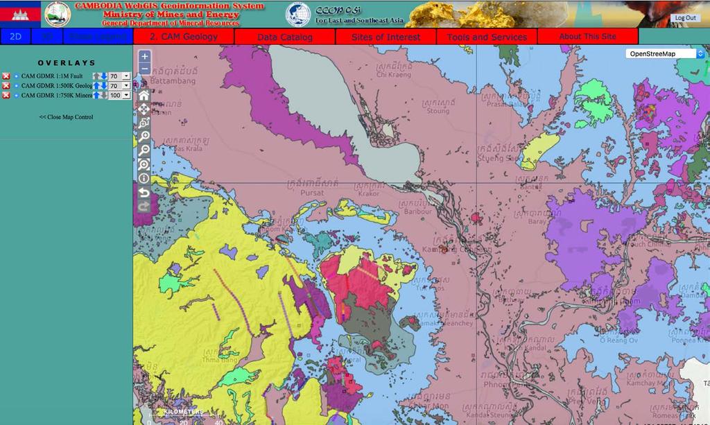
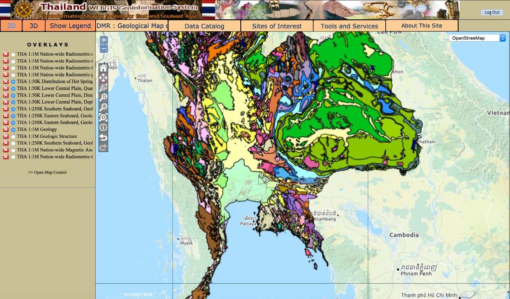
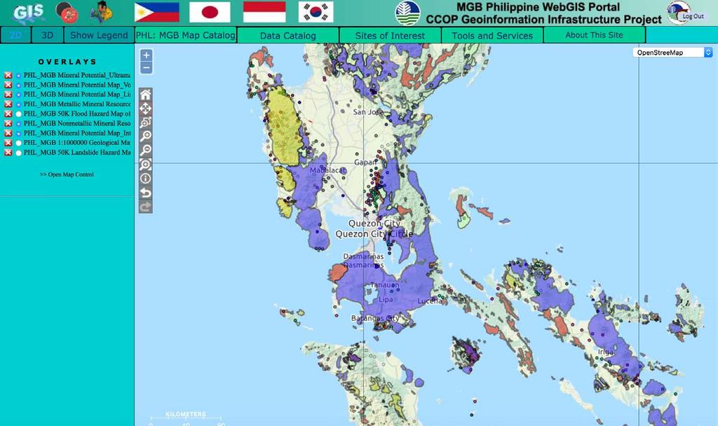
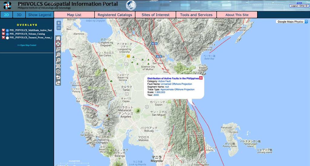
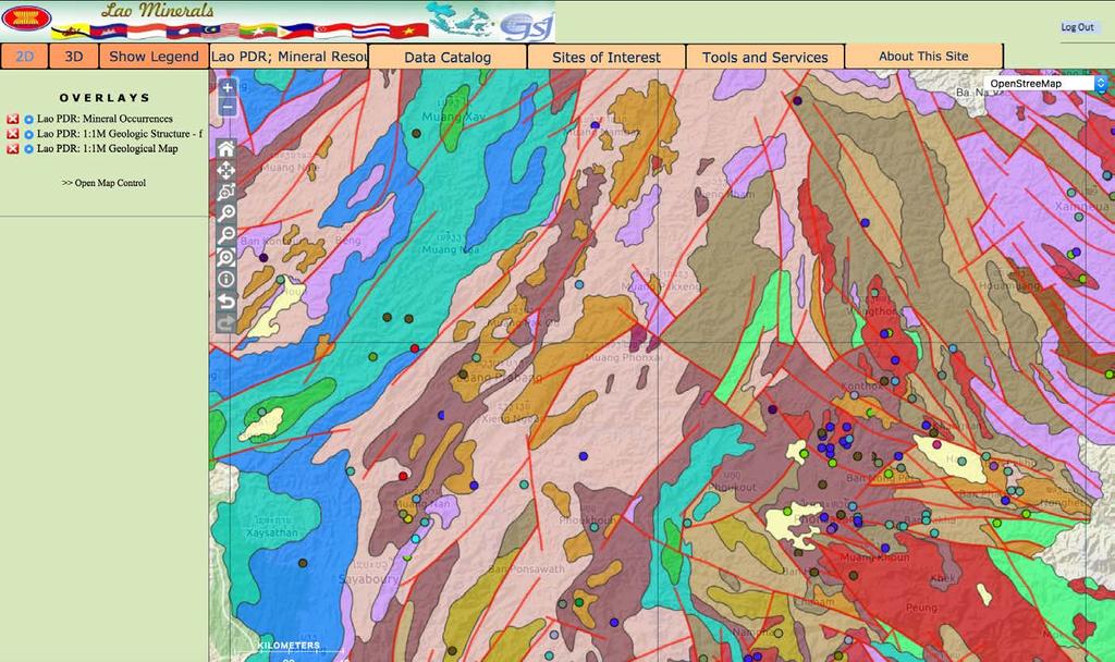
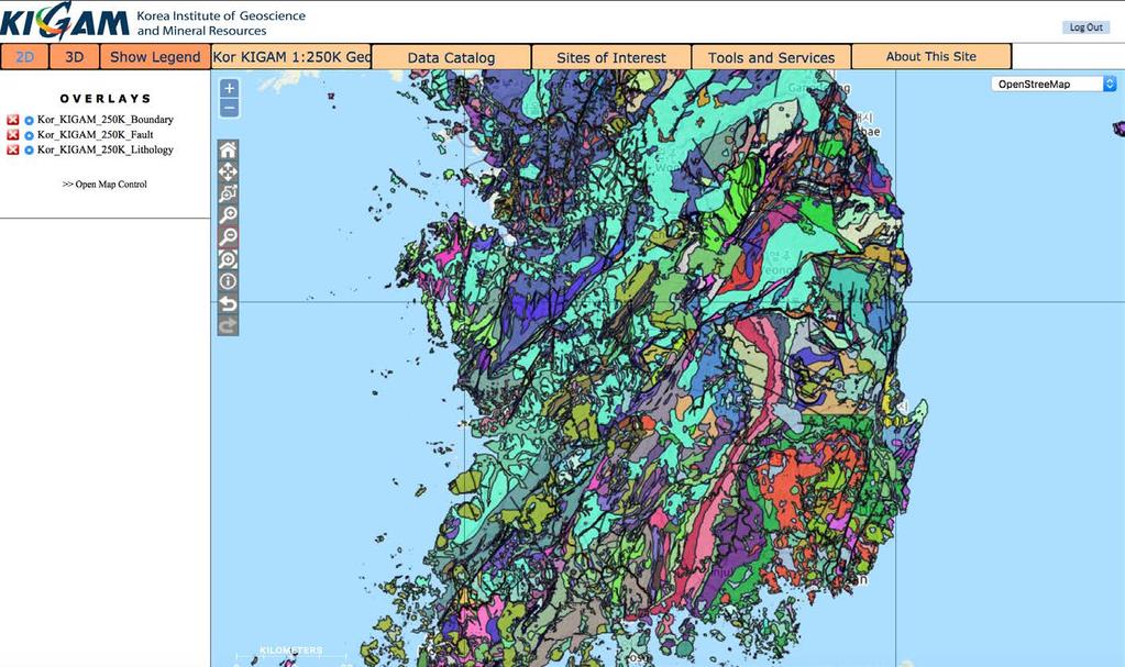
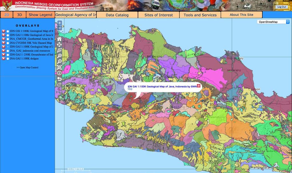
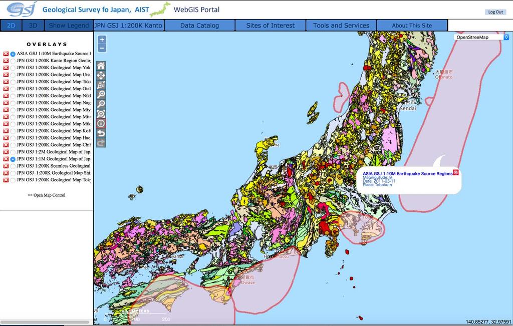
15 Preliminary portal sites of member countries eg: 15

16 Mobile Version 16


17 Register to OneGeology Portal Data on CCOP GSi system Plan to register on OneGeology Portal 17
18 3D Geological Model in Urban Area
19


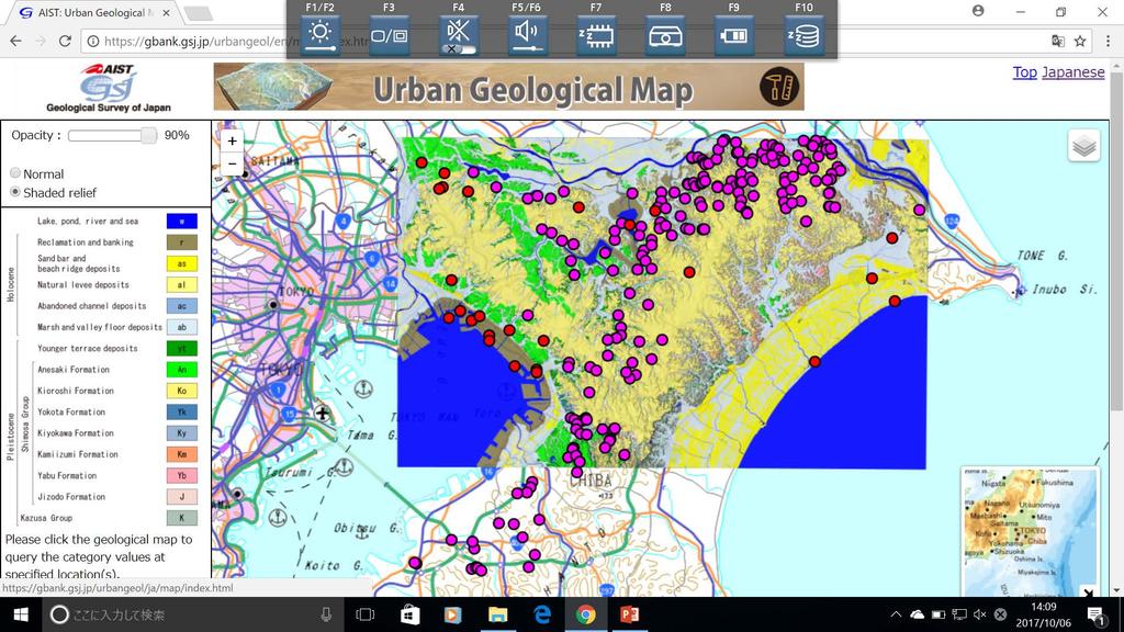
20 Web site Urban Geological Map Under construction: display of cross-sections and 3D models Cross-section along arbitrary line 2D geological map Borehole 20 data 3D geological models

21 3D Geological Model of Pleistocene strata in Chiba area Tokyo Chiba Pacific Tokyo Bay Kioroshi Fm, MIS5e Kiyokawa Fm, MIS7c Kamiizumi Fm, MIS7e Shimosa Group 21 MIS:Marine Oxygen Isotope Stage MIS5e: ~125ka MIS7c: ~210ka MIS7e: ~240ka Each Formation corresponds to sedimentary cycle (transgression-regression)

22 Chiba City, southeast of Tokyo Basal surface of artificial fills 2011 Tohoku-Oki Earthquake caused severe liquefaction in these fills.
23 Thank you very much
3-04 東 東南アジアの地質情報総合データベースの構築 : CCOP 地質情報総合共有プロジェクト
 3-04 東 東南アジアの地質情報総合データベースの構築 : CCOP 地質情報総合共有プロジェクト 宝田晋治 1 Joel Bandibas 1 Constructing a comprehensive geoscience database in East and Southeast Asia: CCOP Geoinformation Sharing Infrastructure for East
LANDSLIDE MITIGATION IN CCOP
 "International Workshop on Landslide Risk Assessment and Management for ASEAN Member States 1-2 June 2017 Bangkok, Thailand LANDSLIDE MITIGATION IN CCOP Dr. Adichat Surinkum Director Email: adichat_s@ccop.or.th,
PROPOSED CCOP WORKPLAN 2019
 CCOP-54AS/6- CCOP-71SC/3-4 as of 10 October 2018 COORDINATING COMMITTEE FOR GEOSCIENCE PROGRAMMES IN EAST AND SOUTHEAST ASIA (CCOP) 54 th CCOP Annual Session 71 st CCOP Steering Committee Meeting 28 October
UNITED NATIONS E/CONF.97/5/CRP. 7
 UNITED NATIONS E/CONF.97/5/CRP. 7 ECONOMIC AND SOCIAL COUNCIL Seventeenth United Nations Regional Cartographic Conference for Asia and the Pacific Bangkok, 18-22 September 2006 Item 6 (b) of the provisional
Capacity Building in Applications of Remote Sensing and GIS for Disaster Management
 Capacity Building in Applications of Remote Sensing and GIS for Disaster Management M.K. Hazarika, L. Samarakoon, N. Senevirathne, J.S.M. Fowze and R. de Silva Project Researcher GeoInformatics Center
E/ESCAP/68/INF/4 Introduction Outreach Cooperation and Partnership Knowledge Enhancement and Sharing Data and Information
 E/ESCAP/68/INF/4 Distr.: For participants only 20 April 2012 English only Economic and Social Commission for Asia and the Pacific Sixty-eighth session Bangkok, 17-23 May 2012 Item 3 (d) of the provisional
PROJECT DOCUMENT ACHIEVEMENTS FOR YEAR 2018 AND PROPOSED ACTIVITY FOR YEAR 2019
 Forty-first Meeting of the Program Committee Southeast Asian Fisheries Development Center Bayview Hotel, Langkawi, Malaysia 5-7 November 2018 WP03.1.1.15 PROJECT DOCUMENT ACHIEVEMENTS FOR YEAR 2018 AND
MINISTRY OF NATURAL RESOURCES AND ENVIRONMENT Vietnam Institute of Geosciences and Mineral Resources (VIGMR)
") MINISTRY OF NATURAL RESOURCES AND ENVIRONMENT (VIGMR) Nguyen Quoc Dinh Representative of VIGMR to Sentinel Asia Awaji, Japan, November 1 st,2018 CONTENTS INTRODUCTION TO VIGMR COOPERATION and CONTRIBUTION
MINISTRY OF NATURAL RESOURCES AND ENVIRONMENT (VIGMR) Nguyen Quoc Dinh Representative of VIGMR to Sentinel Asia Awaji, Japan, November 1 st,2018 CONTENTS INTRODUCTION TO VIGMR COOPERATION and CONTRIBUTION
Natural Disasters in Member Countries (2002 Summary)
") 4.2 Member Countries and their Disaster Characteristics: Table 5: Natural Disasters in Member Countries (2002 Summary) (Country/Disaster Type/Disaster Characteristics) Data Country DisType Count of TotAff
4.2 Member Countries and their Disaster Characteristics: Table 5: Natural Disasters in Member Countries (2002 Summary) (Country/Disaster Type/Disaster Characteristics) Data Country DisType Count of TotAff
Report of PCGIAP to the 18 th United Nations Regional Cartographic Conference for Asia and the Pacific (UNRCC-AP) for the period
 for the period") Permanent Committee on GIS Infrastructure for Asia and the Pacific (PCGIAP) Established in 1995 by a United Nations Resolution Report of PCGIAP to the 18 th United Nations Regional Cartographic Conference
Permanent Committee on GIS Infrastructure for Asia and the Pacific (PCGIAP) Established in 1995 by a United Nations Resolution Report of PCGIAP to the 18 th United Nations Regional Cartographic Conference
Geological information for Europe : Towards a pan-european Geological Data Infrastructure
 Geological information for Europe : Towards a pan-european Geological Data Infrastructure Integrating geoscientific information for EU competitiveness Co-funded by the European Union European societal
RESAP Progress Report
 RESAP Progress Report December 2016 to October 2017 Presentation to the Twenty-first session of the Intergovernmental Consultative Committee on the Regional Space Applications Programme for Sustainable
10 emergency observation requests were successfully processed during the period
 ISRO s Inputs for the Sentinel Asia DPN and JPT meeting being held during 13-16, 16, November 2012 November 2012 Sentinel Asia Activity Spectrum - A dedicated Sentinel Asia server established at NRSC,
The Regional Integrated Multi-Hazard Early Warning System for Africa and Asia CAP in RIMES
 The Regional Integrated Multi-Hazard Early Warning System for Africa and Asia CAP in RIMES 2018 CAP Implementation Workshop OUTLINE 1. RIMES Overview 2. DSS tools developed in RIMES 3. CAP Integration
Report of the Coordinating Committee for Geoscience Programmes in East and Southeast Asia **
 Distr.: For participants only 18 April 2014 English only Economic and Social Commission for Asia and the Pacific Seventieth session Bangkok, 4-8 August 2014 (Phase II) * Item 3(d) of the provisional agenda
History of International Training in Seismology and Earthquake Engineering at IISEE
 History of International Training in Seismology and Earthquake Engineering at IISEE Activities of International Institute of Seismology and Earthquake Engineering (IISEE), BRI - Training for young researchers/engineers
held on 4 June 2013 Prof. Yoshimori Honkura, Program Officer of Japan Science and Technology Agency (JST) Jakarta, Indonesia Pan Pacific Hotel)
 Jakarta, Indonesia Pan Pacific Hotel)") Overview of the Outcomes from e-asia JRP Disaster Prevention Workshop held on 4 June 2013 Prof. Yoshimori Honkura, Program Officer of Japan Science and Technology Agency (JST) Jakarta, Indonesia (@Sari
Overview of the Outcomes from e-asia JRP Disaster Prevention Workshop held on 4 June 2013 Prof. Yoshimori Honkura, Program Officer of Japan Science and Technology Agency (JST) Jakarta, Indonesia (@Sari
Ryuji Yamada Tokyo Climate Center Japan Meteorological Agency E mail: URL:
 Ryuji Yamada Tokyo Center Japan Meteorological Agency E mail: tcc@met.kishou.go.jp URL: http://ds.data.jma.go.jp/tcc/tcc/index.html Tokyo Center (TCC) Established in April 2002 at JMA to support climate
Cooperating Country Report of GERMANY
 CCOP-47AS/4.1-19 COORDINATING COMMITTEE FOR GEOSCIENCE PROGRAMMES IN EAST AND SOUTHEAST ASIA (CCOP) 47 th CCOP Annual Session 17-21 October 2010 Manado, Indonesia Cooperating Country Report of GERMANY
Report of the Working Group 2 Data Sharing and Integration for Disaster Management *
 UNITED NATIONS E/CONF.104/6 ECONOMIC AND SOCIAL COUNCIL Twentieth United Nations Regional Cartographic Conference for Asia and the Pacific Jeju, 6-9 October 2015 Item 5 of the provisional agenda Report
Space Applications for Disaster Risk Reduction and Sustainable Development
 Space Applications for Disaster Risk Reduction and Sustainable Development Space Applications Section (SAS) ICT and Disaster Risk Reduction Division (IDD) UNESCAP Contents I. RESAP Activities 2016-2017
Cooperating Organization Report of Circum Pacific Council for Energy and Mineral Resources (CPC)
") CCOP-41AS/6.2-29 Coordinating Committee for Geoscience Programmes in East and Southeast Asia (CCOP) 41 st CCOP Annual Session 15 18 November 2004 Tsukuba, Japan Cooperating Organization Report of Circum
CCOP-41AS/6.2-29 Coordinating Committee for Geoscience Programmes in East and Southeast Asia (CCOP) 41 st CCOP Annual Session 15 18 November 2004 Tsukuba, Japan Cooperating Organization Report of Circum
IGOS Geohazards: toward an improved use of Earth Observations for Geohazards mitigation
 IGOS Geohazards: toward an improved use of Earth Observations for Geohazards mitigation Scientific and Technical Subcommittee session Vienna, 15th February 2007 Gonéri Le Cozannet IGOS Geohazards Bureau
Joint RA II/V Workshop on WIGOS for DRR - The Jakarta Declaration - (12-14 October, Jakarta, Indonesia) NMSC/KMA
 NMSC/KMA") Joint RA II/V Workshop on WIGOS for DRR - The Jakarta Declaration - (12-14 October, Jakarta, Indonesia) /KMA dolong@korea.kr Background Enhancement of Member s capabilities for weather forecasts and warnings
Joint RA II/V Workshop on WIGOS for DRR - The Jakarta Declaration - (12-14 October, Jakarta, Indonesia) /KMA dolong@korea.kr Background Enhancement of Member s capabilities for weather forecasts and warnings
Journey of supporting CSNs to establish Geo-DRM
 Regional Workshop on Geo-referenced Information Systems for Disaster Risk Management (Geo-DRM) 26-27 June 2014 Bangkok, Thailand Journey of supporting CSNs to establish Geo-DRM Keran Wang Chief, Space
ESCAP Promotes Geo-referenced Information System for Disaster Risk Management in Asia and the Pacific
 Third High Level Forum on UNGGIM 22-24 October 2014 Beijing, China ESCAP Promotes Geo-referenced Information System for Disaster Risk Management in Asia and the Pacific Keran Wang Space Applications Section,
THE SALB PROJECT: STATE OF PROGRESS IN ASIA AND THE PACIFIC SINCE THE 8 th SEASC
 THE SALB PROJECT: STATE OF PROGRESS IN ASIA AND THE PACIFIC SINCE THE 8 th SEASC Chandima Subasinghe 1, Yaniss Guigoz 2, Lal Samarakoon 1, Steeve Ebener 2 1 Geoinformatics Center, Asian Institute of Technology
East Asia Tariff Concession: A CGE analysis
 East Asia Tariff Concession: A CGE analysis 19 June 2015 Kenichi Kawasaki, RIETI Badri Narayanan, Purdue University Houssein Guimbard, CEPII Arata Kuno, Kyorin University 29 October 2011 Overview East
DEVELOPMENT OF GPS PHOTOS DATABASE FOR LAND USE AND LAND COVER APPLICATIONS
 DEVELOPMENT OF GPS PHOTOS DATABASE FOR LAND USE AND LAND COVER APPLICATIONS An Ngoc VAN and Wataru TAKEUCHI Institute of Industrial Science University of Tokyo 4-6-1 Komaba, Meguro-ku, Tokyo 153-8505 Japan
National Hydro-Meteorological Service
 National Hydro-Meteorological Service IMPROVING INSTITUTIONAL NAL CAPACITY (IN CASE OF VIETNAM) Country Report for the first meeting of the RA-II (Asia) Working Group on Hydrological Forecasts and Assessments
Applied Geoscience and Technology Division SOPAC. Joy Papao, Risk Information Systems Officer
 Joy Papao, Risk Information Systems Officer Secretariat of the Pacific Community SPC 22 Pacific Island States Head office in Noumea, New Caledonia 2 Regional offices (Pohnpei and Honiara) 600 staff 9 Technical
Development of Global Map for GEOSS SBAs US-09-03a
 Development of Global Map for GEOSS SBAs US-09-03a UIC User Engagement Session 2 November, 2010 Yoshikazu FUKUSHIMA Secretariat General of International Steering Committee for Global Mapping Geospatial
Human Capacity Building for Natural Resources Development and its Environmental Impacts Tsukuba, Japan, Nov.-Dec., 2007
 Human Capacity Building for Natural Resources Development and its Environmental Impacts Tsukuba, Japan, Nov.-Dec., 2007 APEC Industrial, Science and Technical Working Group March 2008 APEC Project No.:
United Nations, UNGEGN, and support for national geographical names standardization programmes
 Philippines, 2018 United Nations, UNGEGN, and support for national geographical names standardization programmes Helen Kerfoot, UNGEGN Cecille Blake, UNGEGN Secretariat What is important to know? Background
UNITED NATIONS E/CONF.97/6/IP. 8
 UNITED NATIONS E/CONF.97/6/IP. 8 ECONOMIC AND SOCIAL COUNCIL Seventeenth United Nations Regional Cartographic Conference for Asia and the Pacific Bangkok, 18-22 September 2006 Item 7 of the provisional
Member Country Report of LAO PDR
 CCOP-48AS/3-9 COORDINATING COMMITTEE FOR GEOSCIENCE PROGRAMMES IN EAST AND SOUTHEAST ASIA (CCOP) 48 th CCOP Annual Session 4-8 November 2012 Langkawi, Malaysia Member Country Report of LAO PDR Submitted
Sentinel Asia Data Provider Node Report
 Sentinel Asia Data Provider Node Report Joint Project Team Meeting for Sentinel Asia STEP3 (JPTM2018) 23 24 January 2018, Taipei, Taiwan Yuji TAKADA Space Applications and Operations Center (SAOC) Japan
JMA s Cooperation with
 JMA s Cooperation with the Pacific Island Countries (PICs) Tomoyuki KITAMURA Japan Meteorological Agency Bali, Indonesia, 7 March 2018 Contents Background Steps to issue weather forecast/warning JMA s
ISCGM Informal Meeting in Malaysia
 NEWSLETTER 51 International Steering Committee for Global Mapping GLOBAL MAPPING ISCGM Informal Meeting in Malaysia Shozo Kajikawa ISCGM Secretariat The 14th Meeting of PCGIAP was held in Kuala Lumpur,
DISTINGUISHED GUESTS POSITION / ADDRESS. List of Participants (As of 23 March 2015)
") CCOP - KIGAM Unconventional Oil and Gas Project: Mapping of Black Shale Formations for the prediction of shale resources (UnCon) National Coordinators Meeting & Technical Session (UnCon M1) 22 23 March
CCOP - KIGAM Unconventional Oil and Gas Project: Mapping of Black Shale Formations for the prediction of shale resources (UnCon) National Coordinators Meeting & Technical Session (UnCon M1) 22 23 March
Crowdsourcing approach for large scale mapping of built-up land
 Crowdsourcing approach for large scale mapping of built-up land Kavinda Gunasekara Kavinda@ait.asia Geoinformatics Center Asian Institute of Technology, Thailand. Regional expert workshop on land accounting
MEMBER REPORT. Singapore. ESCAP/WMO Typhoon Committee 9 th Integrated Workshop October 2014 ESCAP UN Conference Center, Bangkok, Thailand
 MEMBER REPORT ESCAP/WMO Typhoon Committee 9 th Integrated Workshop 20 24 October 2014 ESCAP UN Conference Center, Bangkok, Thailand CONTENTS I. Overview of tropical cyclones which have affected/impacted
From PCGIAP to UN GGIM AP: A Regional Perspective on GGIM
 Regional Committee of United Nations Global Geospatial Information Management for Asia and the Pacific (UN-GGIM-AP) Established by a United Nations Resolution From PCGIAP to UN GGIM AP: A Regional Perspective
Sentinel Asia Tsunami Working Group
 Sentinel Asia Tsunami Working Group Co-Chairman: Prof. Shunichi Koshimura Abdul Muhari, PhD 4 th Joint Project Team Meeting (JPTM 2017): Sentinel Asia STEP 3 Abdul MUHARI, PhD Ministry of Marine Affairs
Development of a Regional Land Cover Monitoring System In the Lower Mekong Region a Joint Effort Between SERVIR-Mekong and Partners -
 Mekong Development of a Regional Land Cover Monitoring System In the Lower Mekong Region a Joint Effort Between SERVIR-Mekong and Partners - Aekkapol Aekakkararungroj SERVIR-Mekong Asian Disaster Preparedness
SYNERGY OF SATELLITE REMOTE SENSING AND SENSOR NETWORKS ON GEO GRID
 SYNERGY OF SATELLITE REMOTE SENSING AND SENSOR NETWORKS ON GEO GRID National Institute of Advanced Industrial Science and Technology, Japan Yoshio Tanaka (on behalf of AIST GEO Grid team) Contents Brief
Report for 15th PCGIAP Meeting at 18th UNRCC-AP Working Group 1 Regional Geodesy
 Report for 15th PCGIAP Meeting at 18th UNRCC-AP Working Group 1 Regional Geodesy Chairman Shigeru Matsuzaka, Japan - shigeru@gsi.go.jp Vice Chairman Prof. Pengfei Cheng, China - chengpf@casm.ac.cn John
GI Technology for Disaster Management
 GI Technology for Disaster Management 17 th ICC on the Regional Space Applications Programme for Sustainable Development (RESAP) 26 th Nov 2013 Bangkok Thailand Period and time of seasonal in thailand
South, Southeast, and East Asia. Physical Geography
 South, Southeast, and East Asia Physical Geography Mountains v Mountains are important in Asia because they influence: A. Population patterns B. Movement of people and goods C. Climate Mountains v The
PTV South Asia City Map 2015 (Standardmap)
") (Standardmap) Map version name (Core) Map version name (Logistic) Release date (Logistics) Map version name (Logistics) (new) PTV_South_Asia_City_Map_2015 Data provider(s) Technology Region Predecessor
(Standardmap) Map version name (Core) Map version name (Logistic) Release date (Logistics) Map version name (Logistics) (new) PTV_South_Asia_City_Map_2015 Data provider(s) Technology Region Predecessor
Geological Survey of Canada Lands and Minerals Sector Natural Resources Canada OneGeology, June 2018
 Geological Survey of Canada Lands and Minerals Sector Natural Resources Canada OneGeology, June 2018 Geological Survey of Canada Mission The Geological Survey of Canada provides public geoscience knowledge
SEACLID/CORDEX Southeast Asia: A Regional Initiative to Provide Regional Climate Change Information and Capacity Building
 SEACLID/CORDEX Southeast Asia: A Regional Initiative to Provide Regional Climate Change Information and Capacity Building Liew Ju Neng SEACLID/CORDEX Southeast Asia School of Environment and Natural Sciences
Overview of the global FFGS
 Overview of the global FFGS 1 Definition of the Problem While there are several types of floods, flash floods are the most dangerous. Flash Flood is: a flood of short duration with a relatively high peak
CGIANNUAL REPORT 2018 Content
 CGIANNUAL REPORT 2018 Content 1. Main role of CGI... 1 2. Role within IUGS science policy... 1 3. Organization, Council members and officers... 1 4. Extent of support from sources other than IUGS... 3
A Questionnaire on the Utilization of Satellite Data from the New Generation of Geostationary Meteorological Satellites
 3.1 User requirements for satellite data utilization, especially for new-generation satellites A Questionnaire on the Utilization of Satellite Data from the New Generation of Geostationary Meteorological
Utilization of Global Map for Societal Benefit Areas
 Utilization of Global Map for Societal Benefit Areas The Fourth GEOSS AP Symposium Bali Indonesia, 11th March 2010 Shuhei Kojima Geographical Survey Institute Ministry of Land, Infrastructure, Transport
Implementing an online spatial database using the GRASS GIS environment
 Proceedings of the Open source GIS - GRASS users conference 2002 - Trento, Italy, 11-13 September 2002 Implementing an online spatial database using the GRASS GIS environment Venkatesh Raghavan*, Shinji
RiskCity Training package on the Application of GIS for multi- hazard risk assessment in an urban environment.
 RiskCity Training package on the Application of GIS for multi- hazard risk assessment in an urban environment. Cees van Westen (Westen@itc.nl) & Nanette C. Kingma (Kingma@itc.nl) ITC: Training & Research
Australia Government Geospatial Capacity Building Efforts in Asia and the Pacific. Dr John Dawson
 Australia Government Geospatial Capacity Building Efforts in Asia and the Pacific Dr John Dawson Presentation Overview About Geoscience Australia Examples of Geospatial Capacity Building Activity Geodesy
A Data Fusion Approach to Real-time Monitoring Systems and Information Management
 Landslide Preparedness in the ASEAN Member States A Data Fusion Approach to Real-time Monitoring Systems and Information Management Jessada Karnjana, PhD National Electronics and Computer Technology Center
April 20, 2017 The Dharmawangsa Hotel, Jakarta. Understanding Indonesia s Regional Exploration Potential TOBIAS MAYA PT.
 April 20, 2017 The Dharmawangsa Hotel, Jakarta Understanding Indonesia s Regional Exploration Potential TOBIAS MAYA PT. GEO SEARCH 55Ma 54Ma 53Ma 52Ma 51Ma 50Ma 49Ma 48Ma 47Ma 46Ma 45Ma 44Ma 43Ma 42Ma
By Geri Flanary To accompany AP Human Geography: A Study Guide 3 rd edition By Ethel Wood
 Session 1 By Geri Flanary To accompany AP Human Geography: A Study Guide 3 rd edition By Ethel Wood WHAT IS DEMOGRAPHY? It is the scientific or statistical study of population. It comes from the Greek
Cambridge International Examinations Cambridge International General Certificate of Secondary Education
 Cambridge International Examinations Cambridge International General Certificate of Secondary Education *4298138811* ENVIRONMENTAL MANAGEMENT 0680/23 Paper 2 October/November 2014 1 hour 45 minutes Candidates
Tectonic Hazard Evaluations for Korean Nuclear Sites
 Tectonic Hazard Evaluations for Korean Nuclear Sites June 13-17, 2011 Jakarta, INDONESIA Hyunwoo LEE (heanu@kins.re.kr) Korea Institute of Nuclear Safety 1 2 3 4 5 Introduction Tectonic Environment of
Free Open Source Software: FOSS Based GIS for Spatial Retrievals of Appropriate Locations for Ocean Energy Utilizing Electric Power Generation Plants
 Free Open Source Software: FOSS Based GIS for Spatial Retrievals of Appropriate Locations for Ocean Energy Utilizing Electric Power Generation Plants Kohei Arai 1 Graduate School of Science and Engineering
Keywords: Tohoku earthquake, Liquefaction, Hot spot, Pipeline damage, Topographic history
 Liquefaction Hot-Spot Based on Pipeline Damage and Topographical History in the Kashima Region during the 2011 off the Pacific Coast of Tohoku Earthquake Y. Kuwata & D. Ikejiri Kobe University, Japan SUMMARY:
Asian Marine Geology : A Gate to the Future
 8 th International Conference on Asian Marine Geology (ICAMG-8) Asian Marine Geology : A Gate to the Future SECOND CIRCULAR The organizing committee of ICAMG-8 cordially invites you to the 8 th International
PROJECT LIST BY COUNTRY
 PROJECT LIST BY COUNTRY COUNTRY PROJECT NO. TITLE DATE BANGLADESH 16 HYDROGEOLOGY Well Design 36 GEOPHYSICAL STUDIES Digitisation and interpretation of BGS overseas gravity and aeromagnetic data 04/1982
PRELIMINARY STUDY OF GROUND MOTION CHARACTERISTICS IN FURUKAWA DISTRICT, JAPAN, BASED ON VERY DENSE SEISMIC-ARRAY-OBSERVATION
 Proceedings of the International Symposium on Engineering Lessons Learned from the 2011 Great East Japan Earthquake, March 1-4, 2012, Tokyo, Japan PRELIMINARY STUDY OF GROUND MOTION CHARACTERISTICS IN
PTV South Asia City Map 2016 (Standardmap)
") PTV South Asia City Map 2016 (Standardmap) Map version name (Core) Map version name (Logistic) Release date (Logistics) Map version name (Logistics) (new) PTV_South_Asia_City_Map_2016 Data provider(s)
PTV South Asia City Map 2016 (Standardmap) Map version name (Core) Map version name (Logistic) Release date (Logistics) Map version name (Logistics) (new) PTV_South_Asia_City_Map_2016 Data provider(s)
Report of the Regional Committee of UN-GGIM for Asia and the Pacific (UN-GGIM-AP)
") Report of the Regional Committee of UN-GGIM for Asia and the Pacific (UN-GGIM-AP) At the Eighth Session of UN-GGIM UN Headquarters, New York, 1 3 August 2018 About UN-GGIM-AP One of the five regional committees
Report of the Regional Committee of UN-GGIM for Asia and the Pacific (UN-GGIM-AP) At the Eighth Session of UN-GGIM UN Headquarters, New York, 1 3 August 2018 About UN-GGIM-AP One of the five regional committees
GEO-VIII November Geohazard Supersites and Natural Laboratories Progress Report. Document 9
 GEO-VIII 16-17 November 2011 Geohazard Supersites and Natural Laboratories Progress Report Document 9 This document is submitted to GEO-VIII for information. Geohazard Supersites and Natural Laboratories
One map policy (OMP) implementation strategy to accelerate mapping of regional spatial planing (RTRW) in Indonesia
 implementation strategy to accelerate mapping of regional spatial planing (RTRW) in Indonesia") IOP Conference Series: Earth and Environmental Science PAPER OPEN ACCESS One map policy (OMP) implementation strategy to accelerate mapping of regional spatial planing (RTRW) in Indonesia To cite this
IOP Conference Series: Earth and Environmental Science PAPER OPEN ACCESS One map policy (OMP) implementation strategy to accelerate mapping of regional spatial planing (RTRW) in Indonesia To cite this
STI for Climate Extremes
 STI for Climate Extremes Fredolin Tangang Professor, Universiti Kebangsaan Malaysia Adjunct Professor, Ramkhamhaeng University, Bangkok, Thailand SEP Member, NADMA Fellow, Academy of Science Malaysia Bengkel
Applying Hazard Maps to Urban Planning
 Applying Hazard Maps to Urban Planning September 10th, 2014 SAKAI Yuko Disaster Management Expert JICA Study Team for the Metro Cebu Roadmap Study on the Sustainable Urban Development 1 Contents 1. Outline
Working Group 1. Geodetic Reference Frame. Activity Report. for. The UN-GGIM-AP Plenary Meeting
 Regional Committee of United Nations Global Geospatial Information Management for Asia and the Pacific (UN-GGIM-AP) Established by a United Nations Resolution Working Group 1 Geodetic Reference Frame Activity
Chapter 24 Test on Southeast Asia
 Name Score Chapter 24 Test on Southeast Asia Part 1 - Multiple Choice (24 pts.) Read the following statements carefully. Select and circle the most correct choice from among the choices provided. 1. Which
Investigation, assessment and warning zonation for landslides in the mountainous regions of Vietnam
 Investigation, assessment and warning zonation for landslides in the mountainous regions of Vietnam (State-Funded Landslide Project SFLP) Dr. Eng. Le Quoc Hung Add: 67 Chien Thang Street, Ha Dong District,
Georeferencing and Satellite Image Support: Lessons learned, Challenges and Opportunities
 Georeferencing and Satellite Image Support: Lessons learned, Challenges and Opportunities Shirish Ravan shirish.ravan@unoosa.org UN-SPIDER United Nations Office for Outer Space Affairs (UNOOSA) UN-SPIDER
Compilation of serial maps on karst geology of China and Southeast Asia
 Compilation of serial maps on karst geology of China and Southeast Asia XU Qi 1, 2, YANG Xiang-peng 2, ZHANG Fa-wang 2*, BI Xue-li 2, SHI Jian 2, CHEN Zhen 2, ZHOU Li-xin 2, YANG Chen 2 1 National Engineering
Contribution of Sentinel Asia Activities to Disaster Management in Asia Pacific Region: Sentinel Asia Success Story in the Philippines Project
 Contribution of Sentinel Asia Activities to Disaster Management in Asia Pacific Region: Sentinel Asia Success Story in the Philippines Project Arturo Daag PHIVOLCS, PHILIPPINES 13 October 2015 Bangkok
Hazard and Vulnerability of Moderate Seismicity Regions
 Hazard and Vulnerability of Moderate Seismicity Regions presented by Professor Tso-Chien PAN Dean, College of Engineering Director, 25 October 2010 DRM GDLN Session on Earthquake Vulnerability Reduction
Development and Applications of the Global Map. Taro UBUKAWA
 Development and Applications of the Global Map 11 Development and Applications of the Global Map Taro UBUKAWA Abstract The Geographical Survey Institute of Japan has been implementing the Global Mapping
Asia. JigsawGeo. Free Printable Maps for Geography Education. Try our geography games for the ipod Touch or iphone.
 Free Printable Maps for Geography Education Map with region names shown Map without names, for coloring or quizzes Map with coordinate system, for location practice Answer key for coordinate system quiz
Department of Urban Environment Systems, Chiba University, Japan. Kajima Technical Research Institute, Kajima Corporation Co., Ltd., Japan.
 Proceedings of the Tenth Pacific Conference on Earthquake Engineering Building an EarthquakeResilient Pacific 68 November 5, Sydney, Australia Vulnerability analysis of water distribution pipes based on
Correspondence to: O. Kazaoka Published: 12 November 2015
 doi:10.5194/piahs-372-221-2015 Author(s) 2015. CC Attribution 3.0 License. Subsidence by liquefaction-fluidization in man-made strata around Tokyo bay, Japan: from geological survey on damaged part at
Shuhei Maeda Climate Prediction Division Global Environment and Marine Department Japan Meteorological Agency
 Eighth Session of the Forum on Regional Climate Monitoring, Assessment and Prediction for Asia (FOCRAII) 5-7 April 2012, Beijing, China Shuhei Maeda Climate Prediction Division Global Environment and Marine
Bistandsprosjekter i Sørøst-Asia
 Bistandsprosjekter i Sørøst-Asia -Sikre liv og verdier Lars R. Hole, Hanneke Luijting, Tor Ivar Mathisen og Kristine Gjesdal September 2017 Norwegian Meteorological Institute Background Ministry of Foreign
Building Institutional Capacity for Multi-Hazard Early Warning in Asia and the Pacific Subtitle
 Building Institutional Capacity for Multi-Hazard Early Warning in Asia and the Pacific Subtitle Title Keran Wang Chief, Space Applications Section ICT and Disaster Risk Reduction Division 22 May 2018 Pillar
Establishment of WINDS Ground Station in Sri Lanka. By G.K.D. Amarawardena Additional Secretary Ministry of Disaster Management Sri Lanka
 Establishment of WINDS Ground Station in Sri Lanka By G.K.D. Amarawardena Additional Secretary Ministry of Disaster Management Sri Lanka Contents Background SAS Implementation Progress of WINDS establishment
Global Map: A Tool for Disaster Mitigation for the Asia and Pacific Region
 Global Map: A Tool for Disaster Mitigation for the Asia and Pacific Region D. R. Fraser Taylor Chair, International Steering Committee for Global Mapping (ISCGM) fraser_taylor@carleton.ca www. 18 th United
JICA s Experiences of Connecting Japanese Science & Technologies for Disaster Risk Reduction in Developing Countries
 JICA s Experiences of Connecting Japanese Science & Technologies for Disaster Risk Reduction in Developing Countries Junji WAKUI Deputy Director General, Group Leader Disaster Risk Reduction Group Global
Geospatial Information and Services for Disasters (GIS4D)
") Geospatial Information and Services for Disasters (GIS4D) 31 July 2017 Tae Hyung KIM ICT and Disaster Risk Reduction Division (IDD) UNESCAP 1 About ESCAP Who is ESCAP? United Nations Economic and Social
Geospatial Information and Services for Disasters (GIS4D) 31 July 2017 Tae Hyung KIM ICT and Disaster Risk Reduction Division (IDD) UNESCAP 1 About ESCAP Who is ESCAP? United Nations Economic and Social
Capacity Building on Geoportals. Geoinformatics Centre, AIT, Thailand
 Capacity Building on Geoportals in PIC Geoinformatics Centre, AIT, Thailand Content 1. About Geoinformatics Centre, AIT, Thailand 2. Introduction to Project and Our Contribution 3. Web Maps and Geonode
REPORT ON CHINA NEAR-GOOS Delayed Mode DataBase (CDMDB)
") Sixteenth Session of the IOC/WESTPAC Coordinating Committee for the North-East Asian Regional-Global Ocean Observing System (NEAR-GOOS-CC-XVI) REPORT ON CHINA NEAR-GOOS Delayed Mode DataBase (CDMDB) Yu
Sixteenth Session of the IOC/WESTPAC Coordinating Committee for the North-East Asian Regional-Global Ocean Observing System (NEAR-GOOS-CC-XVI) REPORT ON CHINA NEAR-GOOS Delayed Mode DataBase (CDMDB) Yu
JAXA s satellites for Disaster Risk Reduction
 JAXA s satellites for Disaster Risk Reduction October 9, 2017 Masanobu TSUJI Japan Aerospace Exploration Agency (JAXA) Panel on Space Technology and Applications in Support of theregional Roadmap for Implementing
NGIAs' roles in successful disaster response
 The Second UN-GGIM-AP Plenary Meeting NGIAs' roles in successful disaster response Japan Teheran Iran 28 October 2013 Shin-ichi SAKABE, Director of International Affairs Division Geospatial Information
GEM Faulted Earth. A Global Active Fault and Fault Source Database
 GEM Faulted Earth A Global Active Fault and Fault Source Database Marco Pagani on behalf of GEM Faulted Earth Kelvin Berryman, Carlos Costa, Kerry Sieh Nicola Litchfield, Annemarie Christophersen THIS
ECONOMIC AND SOCIAL COUNCIL
 UNITED NATIONS E/CONF.102/3 ECONOMIC AND SOCIAL COUNCIL Nineteenth United Nations Regional Cartographic Conference for Asia and the Pacific Bangkok, 29 October 1 November 2012 Item 4 of the provisional
Member Country Report of JAPAN
 CCOP-54AS/3-7 COORDINATING COMMITTEE FOR GEOSCIENCE PROGRAMMES IN EAST AND SOUTHEAST ASIA (CCOP) 54 th CCOP Annual Session 28 October 1 November 2018 Busan, Republic of Korea Member Country Report of JAPAN