Big data in the Geoscience: A portal to physical properties Andrew Kingdon, Mark Fellgett and Martin Nayembil
|
|
|
- Alicia Smith
- 5 years ago
- Views:
Transcription
1 Big data in the Geoscience: A portal to physical properties Andrew Kingdon, Mark Fellgett and Martin Nayembil British Geological Survey, Keyworth, Nottingham, NG12 5GG, aki@bgs.ac.uk Geosciences were early adopters of both computing and digital data; the precursors of the SEG-D and SEG-Y geophysical formats date from as far back as Data standards, for seismic (SEG-Y, SEG-D) or geophysical log (LAS, DLIS) data simultaneously make interpretation and visualisation of data practicable but also their binary nature makes applying analytical techniques unusually complex. Specialist software is often required to process and interpret different datatypes. Such problems are exacerbated by historic poor data management practices. Datasets are rarely collated at the end of projects or stored with sufficient metadata to accurately describe them and many strategically useful datasets reach BGS incomplete, unusable or inaccessible. Whether this situation arose through a lack of foresight about the future value of data, poor practise or simply storage space restrictions these problems pose huge challenges to today s geoscientists. Consequently, there are major problems with applying big data analytics to geoscience. For example, many techniques don t sample geology directly but use proxies needing further interpretation. The use of analytical techniques have commonly been limited by the high proportion of noise incorporated into the datasets with very significant interpretation skills required to identify the signal. Thus far successful applications of big data analytics have been limited to closed systems or analyses of very common digital data types. Significant problems remain, including the lack of data that can be immediately interacted with and difficulties in bringing together multiple datasets about related phenomena. Also the lack of adequate metadata about the data available to understand its context and scope and how to apply and qualify results. Whilst geosciences datasets have all the attributes of big data volume, veracity, velocity, value and variety the last two controls are disproportionately significant. The first of these determines the usefulness of the data and the second is the biggest impediment to delivering on the promises that big data offers especially in Earth Sciences. In order to deliver a standardised platform of data from which individual geological attributes can be identified BGS has invested in the creation of PropBase (Kingdon et al., 2016). This single portal facilitates the collation of datasets supplied in standardised formats. This allows all data from a single point feature (e.g. boreholes) or areas of interest) E.G. to be extracted together in a common format allowing all data to be immediately compared. The existence of PropBase portal allows a researcher to answer the question What s available at a location? It has already been used in site characterisation for the UK GeoEnergy Observatories project. Such initiatives that allow collation of high volumes of data in a single extractable format are a critical step forward to allowing Big Data analytics. Combined with the increasing availability and ever lowering cost of high power computing and analytical routines, the opportunities for big data analytics are ever growing. However, substantial challenges remain and new and more interactions with computer scientists are needed to deliver on this promise. References Kingdon A., Nayembil, M.L., Richardson A.E., and Smith, A.G., A geodata warehouse: Using denormalisation techniques as a tool for delivering spatially enabled integrated geological information to geologists. Computers and Geosciences, 96, DOI: /j.cageo

2 Big data in the Geoscience: A portal to physical properties Andrew Kingdon, Martin Nayembil and Mark Fellgett British Geological Survey, Keyworth, Nottingham, NG12 5GG, aki@bgs.ac.uk markf@bgs.ac.uk

3 William Smith s 1815 geological map Big Data and BGS British Geological Survey (BGS) advises government, agencies & public about risks and resources for the UK landmass & UKCS BGS advice sought on ever more complex & controversial decisions Delivering this requires better data access, assimilation, analysis and visualisation Moving from where is it questions to What if scenarios This is not a new challenge

4 Example: UK shale Gas UK shale exploration controversial after 2011 tremors at Preese Hall UK government needed: Location & size of reserves Technical constraints on their production Typical of the complex questions BGS now has to answer
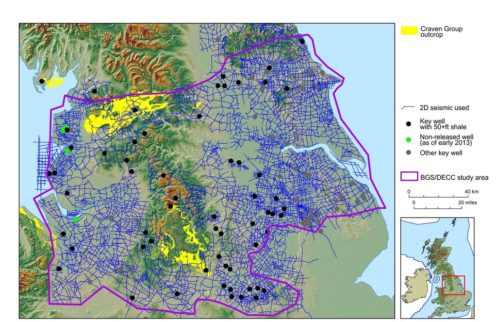
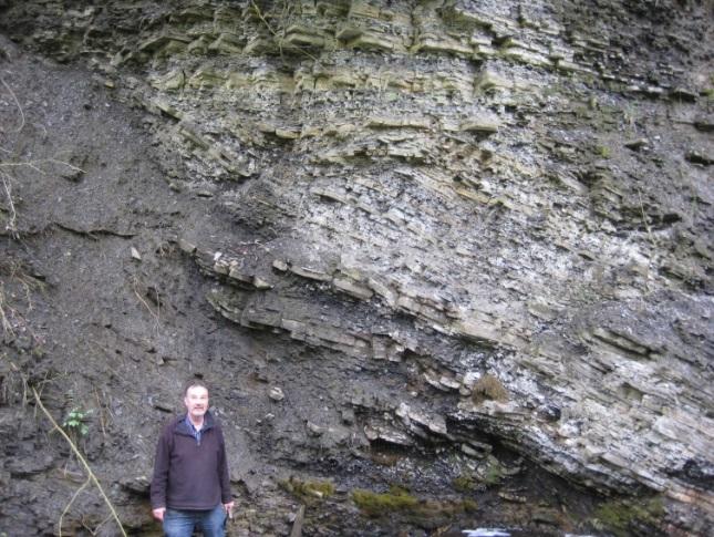
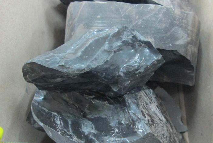
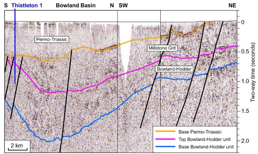
5 UK Shale evaluations Outcrop studies, 64 key wells, 15,000 miles of seismic data Images: BGS; Andrews, 2013


6 Opportunities for Geo Big-Data Quick answer to complex questions need: Rapid data assimilation & analysis Automated interpretation Uncertainty, sensitivity & trend analyses

7 Definitions of Big Data

8 Example geoscience problems Complex interactions between geology & anthropogenic processes Large area Multiple datatypes Multiple ages of data Fast turn-around Data needs standardising to allow analysis BGS has tried phys props mapping in 3D for 20 years Data quality has always prevented it


9 Subsurface Property Data Behaviours of rocks is measured in multiple ways Geomechanical properties Geotechnical properties Geophysical properties Groundwater properties Geochemical Properties Etc. Needed to attribute 3D geology to model impacts of variability on dynamic processes


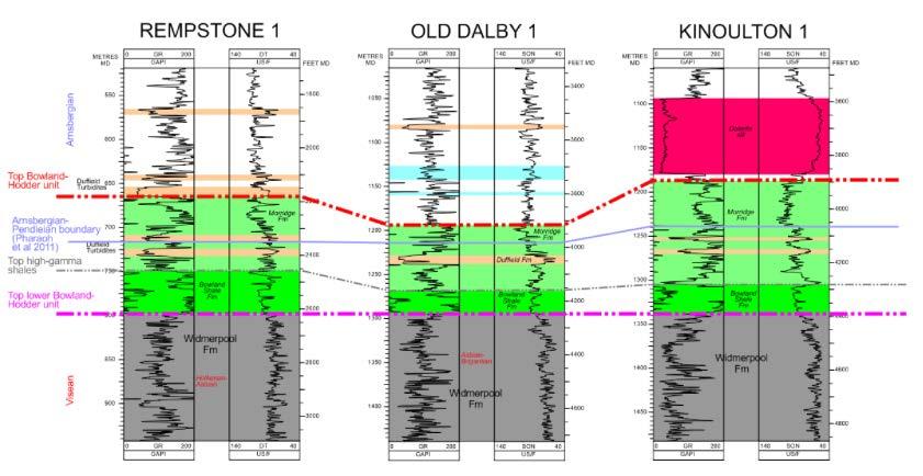
10 Scientific Challenge: Heterogeneity Properties like strength, porosity & permeability affect subsurface processes and are controls on subsurface uses Geologists use complex terms to describe this Engineers & Government need data / information in numbers East Midland SSG porosity model


11 Example: Geology of Glasgow Density Density Scale /Scale gcm-3 / gcm Simulation 10 Simulation 1 Heterogeneous mix of clastic lithologies Complex packages of fluvial, glacial & marine sediments Highly varied physical properties with limited lithostratigraphic control Pollution on development sites across the city Williams,et al Stochastic modelling of hydraulic conductivity derived from geotechnical data; an example applied to Central Glasgow. EARTH ENV SCI T R SO, In Press Kearsey et al., Testing the application and limitation of stochastic simulations to predict the lithology of glacial and fluvial deposits in Central Glasgow, UK. DOI: /j.enggeo Bianchi et,al Integrating deterministic lithostratigraphic models in stochastic realizations of subsurface heterogeneity. Impact on predictions of NERC All rights reserved lithology, hydraulic heads and groundwater fluxes. DOI: /j.jhydrol


12 Constraints on Geo-Big Data Practical Constraints Non-digital data Inadequate metadata Lack of standards Lack of upscaling medium Only comparable data can be compared Big-data analytics need standardised data sets Computing power is not the major control UKOGL 2D UKOGL 3D Coverage Coverage ~31% of ~0.7% of land area land area


13 Maximising value from long-tail data Procedures PropBase Rapid standardised data delivery Software tools Webservices
14 Corporate Databases Property data storage RECALL Corporate Applications Geochemistry DB Web Portals Borehole Geology Borehole Geology Property SOBI Geotechnical DB Geophysics DB Wellmaster DB Aquifer Properties DB Corporate Data Store Corporate GIS Software Systems
15 PropBase QueryLayer Logging Data Stratigraphy & lithology Geotechnical DB Borehole Indexes PropBase Query Layer PropBase Data Access Geochemistry DB Geophysics DB Wellmaster DB Aquifer Properties DB

16 PropBase Data Model Geotech Data Model Geochemistry Data Model
17 Standard PropBase Output Format unique identifier data source unique id from parent DB (for traceability) 3D location (x, y, z) property type property value property units necessary qualifiers precision information audit trail
18 PropBase architecture

19 How does this solve problems? Standardised access allows analysis of: Multiple & large datasets Comparison of many different factors Single input format with toggles between inputs Simplified data analysis Fast response Can quickly answer: what do we know about location X

20 Example: SENSORnet Near Real-Time sensor data Flat file relational database, NOSQL databases and Data Warehouse objects Data access layer

21 UK Geo Observatories BGS s first deep drilling campaign for 30 years Studying subsurface operations to understand UK Energy Aims to provide best possible datasets to understand how rocks behave in the subsurface Data structures and standards must be robust & future-proof


22 UK Geo Observatories: Science & technology questions in subsurface energy Shale gas Groundwater contamination? Combined shale/geothermal? Microwave fracking? CAES Best rocks to do this? CCS Injectivity Biological interactions Gas storage Salt heterogeneity Cavern construction Geothermal Tight sandstones hot water
23 Data to be collected by UK GEOs Baseline geochemistry & seismicity Geophysical surveying Downhole data inc: Core & core measurements borehole imaging geophysical logging Live sensor data Fast accurate outputs Quality assured Timestamped Version control


24 Conclusions: making Geo-Data fit for analytical processing The challenges of the future are complex and uncertain Complex problems need complex analysis to identify trends Analytical tools need large & clean datasets Geoscience datasets are dirty with high signal-noise ratio Often measuring proxies not actual parameters Data standardisation and QA are essential preconditions to analysis PropBase does not undertake analysis, only prepares data NERC Effective All rights reserved preparation makes GeoData analytics a realistic prospect
Development of a national geophysical log data archive: legacy data as a national asset
 Development of a national geophysical log data archive: legacy data as a national asset Andrew Kingdon & Mark Fellgett Contributions by Helen Bonsor & Diarmad Campbell aki@bgs.ac.uk 0115 936 3415 Preserving
Tools for building and delivering 3D models Perspectives by the BGS
 Tools for building and delivering 3D models Perspectives by the BGS Holger Kessler (on behalf of the 3D community of BGS) Kingsley Dunham Centre Keyworth Nottingham NG12 5GG Tel 0115 936 3100 www.bgs.ac.uk/3dg
Does the SDCP need inputs from geology?
 The British Geological Survey s Experience and Expertise in Supporting Projects such as the Sirte Depression Connection Project David Ovadia Director of International Kingsley Dunham Centre Keyworth Nottingham
What is the scope for carbon capture and storage in Northern Ireland. Michelle Bentham
 What is the scope for carbon capture and storage in Northern Ireland Michelle Bentham Kingsley Dunham Centre Keyworth Nottingham NG12 5GG Tel 0115 936 3100 What is Carbon Capture and Storage? Capture of
PETROLEUM GEOSCIENCES GEOLOGY OR GEOPHYSICS MAJOR
 PETROLEUM GEOSCIENCES GEOLOGY OR GEOPHYSICS MAJOR APPLIED GRADUATE STUDIES Geology Geophysics GEO1 Introduction to the petroleum geosciences GEO2 Seismic methods GEO3 Multi-scale geological analysis GEO4
The UK GeoEnergy Test Bed Ceri J Vincent British Geological Survey
 The UK GeoEnergy Test Bed Ceri J Vincent British Geological Survey Thanks to Matthew Hall (GTB Theme Lead for G ERA), Phil Meldrum, Russell Swift, Oliver Kuras, Richard Luckett, Andrew Butcher, Jonathan
3D Geoscience models and their delivery to customers
 3D Geoscience models and their delivery to customers Holger Kessler, Mike Lelliott, Dave Bridge, Jon Ford, Hans-Georg Sobisch, Steve Mathers, Simon Price, Jo Merritt, Bruce Napier & Kate Royse GSA Annual
Geosciences Career Pathways (Including Alternative Energy)
") Geosciences Career Pathways (Including Alternative Energy) Shale Carbonates Clastics Unconventionals Geology Characterization and Production Properties of Gas Shales Geomechanics in International Shale
Geosciences Career Pathways (Including Alternative Energy) Shale Carbonates Clastics Unconventionals Geology Characterization and Production Properties of Gas Shales Geomechanics in International Shale
Storage 4 - Modeling for CO 2 Storage. Professor John Kaldi Chief Scientist, CO2CRC Australian School of Petroleum, University of Adelaide, Australia
 Storage 4 - Modeling for CO 2 Storage Professor John Kaldi Chief Scientist, CO2CRC Australian School of Petroleum, University of Adelaide, Australia 1 Modelling 2 On Models. All models are wrong. some
ASK Network Partnership
 ASK Network Partnership Hugh Barron & Diarmad Campbell, BGS NERC All rights reserved Scottish Water, Shieldhall, 30 August 2013 What is ASK? Accessing Subsurface Knowledge..a knowledge exchange network
GEOCHEMISTRY UNIFORM SYLLABUS
 GEOCHEMISTRY UNIFORM SYLLABUS The Association of Professional Engineers and Geoscientists of the Province of British Columbia Note: 1. This Syllabus May Be Subject To Change 2. These Courses Are Required
Harvey Thorleifson, Director, Minnesota Geological Survey. Status of geological mapping needed for groundwater protection in Minnesota
 Harvey Thorleifson, Director, Minnesota Geological Survey Status of geological mapping needed for groundwater protection in Minnesota Minnesota is located between the Dakotas and Wisconsin, north of Iowa,
An Overview of the Tapia Canyon Field Static Geocellular Model and Simulation Study
 An Overview of the Tapia Canyon Field Static Geocellular Model and Simulation Study Prepared for Sefton Resources Inc. Jennifer Dunn, Chief Geologist Petrel Robertson Consulting Ltd. Outline Background
Storage 6 - Modeling for CO 2 Storage. Professor John Kaldi Chief Scientist, CO2CRC Australian School of Petroleum, University of Adelaide, Australia
 Storage 6 - Modeling for CO 2 Storage Professor John Kaldi Chief Scientist, CO2CRC Australian School of Petroleum, University of Adelaide, Australia Regina, Sask., Canada, 17-22 July, 2016 Modeling 2 What
Seismic validation of reservoir simulation using a shared earth model
 Seismic validation of reservoir simulation using a shared earth model D.E. Gawith & P.A. Gutteridge BPExploration, Chertsey Road, Sunbury-on-Thames, TW16 7LN, UK ABSTRACT: This paper concerns an example
A method for three-dimensional mapping, merging geologic interpretation, and GIS computation
 A method for three-dimensional mapping, merging geologic interpretation, and GIS computation Soller, David R., U.S. Geological Survey, 908 National Center, Reston, VA 20192 and Richard C. Berg, Illinois
Experienced specialists providing consulting services worldwide. Coalbed Methane Consulting Services
 Experienced specialists providing consulting services worldwide Coalbed Methane Consulting Services Proven technical leadership Schlumberger is a world leader in coalbed methane (CBM) engineering and geosciences.
National Geophysical Survey Science Opportunities
 National Geophysical Survey Science Opportunities Anton Ziolkowski Professor of Petroleum Geoscience University of Edinburgh BGS Keyworth 4 April 2016 Outline Brief biography Science opportunities High
BERG-HUGHES CENTER FOR PETROLEUM AND SEDIMENTARY SYSTEMS. Department of Geology and Geophysics College of Geosciences
 BERG-HUGHES CENTER FOR PETROLEUM AND SEDIMENTARY SYSTEMS Department of Geology and Geophysics College of Geosciences MISSION Integrate geoscience, engineering and other disciplines to collaborate with
Geofacets Seminar & Interactive Workshop
 Geofacets Seminar & Workshop University of Bergen Geofacets Seminar & Interactive Workshop UNIVERSITY OF BERGEN Sandra Merten Geofacets Product Manager University of Bergen, 22 March 2017 Geofacets Seminar
Drillworks. DecisionSpace Geomechanics DATA SHEET
 DATA SHEET Drillworks overview DecisionSpace Geomechanics Key features Pre-drill, real-time, and post-drill analyses are all easily performed in one application using the latest data from across the field
Metallic Mineral Exploration in Minnesota: Typical Exploration Activities. Division of Lands and Minerals Minnesota Department of Natural Resources
 Metallic Mineral Exploration in Minnesota: Typical Exploration Activities Division of Lands and Minerals Minnesota Department of Natural Resources Metallic minerals can only be mined economically where
USING EXISTING, PUBLICLY-AVAILABLE DATA TO GENERATE NEW EXPLORATION PROJECTS
 USING EXISTING, PUBLICLY-AVAILABLE DATA TO GENERATE NEW EXPLORATION PROJECTS Philip M. Baker 1, Paul A. Agnew 2 and M. Hooper 1 1 Rio Tinto Exploration, 37 Belmont Ave, Belmont WA 6104. Australia 2 Rio
Man, Machine and Data: A Mineral Exploration Perspective
 Man, Machine and Data: A Mineral Exploration Perspective Eun-Jung Holden, Geodata Algorithms Team The Centre for Exploration Targeting, School of Earth Sciences The University of Western Australia Team
M.Sc. Track Petroleum Engineering & Geosciences
 M.Sc. Track Petroleum Engineering & Geosciences 3-9-2017 Delft University of Technology Challenge the future Challenging industry (and study) 2 Geothermal Energy Produce energy (heat) from subsurface for
Integrating Geomechanics and Reservoir Characterization Examples from Canadian Shale Plays
 Integrating Geomechanics and Reservoir Characterization Examples from Canadian Shale Plays AAPG Geosciences Technology Workshops Geomechanics and Reservoir Characterization of Shale and Carbonates July
Risk Evaluation. Todd Shipman PhD, Alberta Geological Survey/Alberta Energy Regulator November 17 th,2017 Induced Seismicity Workshop, Yellowknife NWT
 Risk Evaluation Todd Shipman PhD, Alberta Geological Survey/Alberta Energy Regulator November 17 th,2017 Induced Seismicity Workshop, Yellowknife NWT Risk Management Approach to Induced Seismicity Establishing
Assessing the Tier 2 Trigger for Fractured Sedimentary Bedrock Sites
 Assessing the Tier 2 Trigger for Fractured Sedimentary Bedrock Sites Ken Lyon, Jennifer Arnold, Louise Burden Advisian WorleyParsons Group RemTech 2015, October 16, Banff, AB INTRODUCTION High level look
Spatial Data Modelling: The Search For Gold In Otago. Presented By Matthew Hill Kenex Knowledge Systems (NZ) Kenex. Kenex
 Kenex. Kenex") Spatial Data Modelling: The Search For Gold In Otago Presented By Matthew Hill Knowledge Systems (NZ) Acknowledgements Michelle Stokes & Greg Partington - Pty Ltd (Australia) Paul Matthews, Charlene Wildman,
Spatial Data Modelling: The Search For Gold In Otago Presented By Matthew Hill Knowledge Systems (NZ) Acknowledgements Michelle Stokes & Greg Partington - Pty Ltd (Australia) Paul Matthews, Charlene Wildman,
Study program: Geology. Semester I Required subject Code Subject ECTS. Hours per week
 Study program: Geology Semester I 2FI100112 Math 1 8 3+2+2 216 2FP100212 Physics 1 8 3+2+2 216 UGD101312 Computer Science 6 2+2+1 156 1 4 2+1+1 120 2 4 2+1+1 120 : 2FP110112 Basics geology 2FP101212 Fundamentals
BGS landslide data and mapping in Britain
 BGS landslide data and mapping in Britain Peter Hobbs British Geological Survey prnh@bgs.ac.uk Kingsley Dunham Centre Keyworth Nottingham NG12 5GG Tel 0115 936 3100 Acknowledgements Thanks to: Andrew Gibson
Collaborative Geotechnical BIM technologies. Carl Grice Software Development Director (Keynetix) Holger Kessler - Team Leader Modelling Systems (BGS)
 Holger Kessler - Team Leader Modelling Systems (BGS)") Collaborative Geotechnical BIM technologies Carl Grice Software Development Director (Keynetix) Holger Kessler - Team Leader Modelling Systems (BGS) 1 2 3 Current Challenges R&D Project Proposed Solution
Collaborative Geotechnical BIM technologies Carl Grice Software Development Director (Keynetix) Holger Kessler - Team Leader Modelling Systems (BGS) 1 2 3 Current Challenges R&D Project Proposed Solution
Assessing our untapped energy resources. Derek Reay Geological Survey of Northern Ireland
 Assessing our untapped energy resources Derek Reay Geological Survey of Northern Ireland Talk Outline Northern Ireland energy market Oil and Gas Exploration Description Exploration risks Application of
Search and Discovery Article #51409 (2017)** Posted August 7, Abstract. Selected References
** Posted August 7, Abstract. Selected References") Saturations of Migrating Buoyant Fluids from Invasion Percolation Flow Simulation Using Small-Scale, High- Resolution Geologic Models With Realistic Heterogeneity* Timothy A. Meckel 1, Luca Trevisan 2,
Saturations of Migrating Buoyant Fluids from Invasion Percolation Flow Simulation Using Small-Scale, High- Resolution Geologic Models With Realistic Heterogeneity* Timothy A. Meckel 1, Luca Trevisan 2,
A national 3D geological model of Denmark: Condensing more than 125 years of geological mapping
 A national 3D geological model of Denmark: Condensing more than 125 years of geological mapping Peter B.E. Sandersen Thomas Vangkilde-Pedersen Geological Survey of Denmark and Greenland Flemming Jørgensen
Belgian Geological data for deep geothermal Energy
 Belgian Geological data for deep geothermal Energy Estelle Petitclerc, Michiel Dusar Geological Survey of Belgium (GSB) Contact: estelle.petitclerc@naturalsciences.be Utrecht, January 24 th, 2012 Available
ENVIRONMENTAL GEOSCIENCE UNIFORM SYLLABUS
 ENVIRONMENTAL GEOSCIENCE UNIFORM SYLLABUS The Association of Professional Engineers and Geoscientists of the Province of British Columbia Note: 1. This Syllabus May Be Subject To Change 2. These Courses
Risk Factors in Reservoir Simulation
 Risk Factors in Reservoir Simulation Dr. Helmy Sayyouh Petroleum Engineering Cairo University 12/26/2017 1 Sources Of Data Petro-physical Data Water saturation may be estimated from log analysis, capillary
Exploration _Advanced geophysical methods. Research Challenges. Séverine Pannetier-Lescoffit and Ute Mann. SINTEF Petroleum Research
 Exploration _Advanced geophysical methods * Research Challenges Séverine Pannetier-Lescoffit and Ute Mann SINTEF Petroleum Research 1 Exploration and Reservoir Characterization * Research Challenges 29%
- Cased-hole geophysical well logs - Airborne geophysics - Seismic data - LiDAR. GeoConvention 2015: New Horizons 1
 Thermal Effects and Quaternary Hydrogeology: Making Good Decisions in a Complex Geologic Setting Timothy Johnsen, Phd, Quaternary Specialist (tjohnsen@matrix-solutions.com) Alex Haluszka, MSc, P.Geol.,
Geothermal Energy in the UK
 Geothermal Energy in the UK Jon Busby British Geological Survey Outline Geothermal energy in the UK Background to geothermal in the UK context UK geothermal resources Engineered geothermal systems Direct
CO 2 storage capacity and injectivity analysis through the integrated reservoir modelling
 CO 2 storage capacity and injectivity analysis through the integrated reservoir modelling Dr. Liuqi Wang Geoscience Australia CO 2 Geological Storage and Technology Training School of CAGS Beijing, P.
THE USE OF GIS IN GEOTHERMAL RESOURCE MANAGEMENT: A CASE STUDY OF OLKARIA GEOTHERMAL PROJECT
 Presented at SDG Short Course II on Exploration and Development of Geothermal Resources, organized by UNU-GTP, GDC and KenGen, at Lake Bogoria and Lake Naivasha, Kenya, Nov. 9-29, 2017. Kenya Electricity
G002 An Integrated Regional Framework for Seismic Depth Imaging in the Deepwater Gulf of Mexico
 G002 An Integrated Regional Framework for Seismic Depth Imaging in the Deepwater Gulf of Mexico M. Davidson (Fugro Multi Client Services), M. Leander (Fugro Multi Client Services), K. Mohn (Fugro Multi
FRIO BRINE SEQUESTRATION PILOT IN THE TEXAS GULF COAST
 I1-2 FRIO BRINE SEQUESTRATION PILOT IN THE TEXAS GULF COAST Susan D. Hovorka and Paul R. Knox Bureau of Economic Geology, John A. and Katherine G. Jackson School of Geosciences, The University of Texas
Spatial Data Management of Bio Regional Assessments Phase 1 for Coal Seam Gas Challenges and Opportunities
 Spatial Data Management of Bio Regional Assessments Phase 1 for Coal Seam Gas Challenges and Opportunities By Dr Zaffar Sadiq Mohamed-Ghouse Principal Consultant, Spatial & IT, GHD zaffar.sadiq@ghd.com
TECHNICAL STUDIES. rpsgroup.com/energy
 TECHNICAL STUDIES RPS Energy - a global energy consultancy RPS Energy is part of the RPS Group plc, a FTSE 250 company with an annual turnover of $700m and over 4700 employees. As one of the world s leading
Petroleum Exploration
 Petroleum Exploration Upstream Petroleum Exploration The role of exploration is to provide the information required to exploit the best opportunities presented in the choice of areas, and to manage research
Predicting rock conditions ahead of the face
 Predicting rock conditions ahead of the face Dr Thomas Dickmann, Product Manager Geophysics, Amberg Technologies AG Seismic methods of predicting rock conditions ahead of the tunnel face have developed
Geological Models for Infrastructure Design:
 Geological Models for Infrastructure Design: Reducing Geotechnical Risk and Supporting Sustainability Alan Keith Turner Emeritus Professor of Geological Engineering CSM Visiting Research Associate - British
Our Services. What We Do. How We Can Help. Contact us today: January (0)
") Listening and Understanding to Optimize our Efficiency Our Experience and Knowledge to Work for You Tailor-made Solutions to Meet your Needs Our Challenge is You Success What We Do Our Services GeoViz
Listening and Understanding to Optimize our Efficiency Our Experience and Knowledge to Work for You Tailor-made Solutions to Meet your Needs Our Challenge is You Success What We Do Our Services GeoViz
MSCL-S: MULTI-SENSOR CORE LOGGER NON-DESTRUCTIVE CONTINUOUS CORE SCANNING FOR INDUSTRY & RESEARCH
 MSCL-S: MULTI-SENSOR CORE LOGGER NON-DESTRUCTIVE CONTINUOUS CORE SCANNING FOR INDUSTRY & RESEARCH IF CORE S WORTH TAKING, IT S WORTH LOGGING AUTOMATED & FLEXIBLE CORE LOGGING & SCANNING The Geotek Standard
BIM and INSPIRE, for a better integration of built infrastructures in their environment : the MINnD project
 BIM and INSPIRE, for a better integration of built infrastructures in their environment : the MINnD project François ROBIDA Christophe CASTAING Strasbourg, > 1 8 septembre 2017 ABOUT BIM Building Information
Key Stage 3 - Volcano Fracking
 After the meeting Come out of your role. Write your own summary of the dilemmas facing the council, and recommend whether or not they should allow fracking to take place. Pupil worksheet is short for hydraulic
SASKATCHEWAN STRATIGRAPHY GLACIAL EXAMPLE BOULDERS IN GLACIAL DEPOSITS
 SASKATCHEWAN STRATIGRAPHY GLACIAL EXAMPLE BOULDERS IN GLACIAL DEPOSITS 51 SASKATCHEWAN STRATIGRAPHY GLACIAL SURFICIAL STRATIFIED DEPOSITS 52 SASKATCHEWAN STRATIGRAPHY GLACIAL EXAMPLE OF SEDIMENT DEPOSITION
GeoTeric. Overview. See the Geology Before you Interpret. Cognitive Interpretation Reveal the Geology, Interpret the Data, Validate your Model.
 GeoTeric Overview See the Geology Before you Interpret Cognitive Interpretation Reveal the Geology, Interpret the Data, Validate your Model. World Leading Cognitive Interpretation COGNITIVE bydesign CONDITION
BHP Billiton Mineral Exploration Perspective Mineral Exploration Imperatives [Key Business Drivers]
![BHP Billiton Mineral Exploration Perspective Mineral Exploration Imperatives [Key Business Drivers]](/thumbs/74/70001151.jpg "BHP Billiton Mineral Exploration Perspective Mineral Exploration Imperatives [Key Business Drivers]") BHP Billiton Mineral Exploration Perspective Mineral Exploration Imperatives [Key Business Drivers] Solid Earth and Environment Grid CANBERRA, July 2003 Liedeke Bosma Chief Geologist Knowledge Management
BHP Billiton Mineral Exploration Perspective Mineral Exploration Imperatives [Key Business Drivers] Solid Earth and Environment Grid CANBERRA, July 2003 Liedeke Bosma Chief Geologist Knowledge Management
GeoVisionary Virtual Fieldwork For Real Geologists
 Page 1 of 9 Monday, February 07, 2011 Subscribe Sitem Home News Articles Dialogue Events Blogs Resources Articles Features GeoVisionary Virtual Fieldwork For Real Geologists GeoVisionary Virtual Fieldwork
Maximising the use of publicly available data: porosity and permeability mapping of the Rotliegend Leman Sandstone, Southern North Sea
 Maximising the use of publicly available data: porosity and permeability mapping of the Rotliegend Leman Sandstone, Southern North Sea Claire Imrie & Henk Kombrink 09 May 2018 Overview The Oil and Gas
3D Modelling of the Uppsala Esker
 3D Modelling of the Uppsala Esker Eva Jirner (SGU) Duncan McConnachie (WSP Sweden) 2017-05-31 ISO/TC211 Geographic Information/Geomatics A collabrative effort Orientation 3 Background Uppsala municiaplity
The Need for Regional Geological Datasets
 The Need for Regional Geological Datasets Dr. Eibhlín Doyle PGeo Geological Survey of Ireland Regional Data Why What Who Future 2006 Why? Place developments in context Land use decision making Assist policy
Subject map. Custodians Geological Curators Group Geoscience Information Group Higher Education Network History of Geology Group
 Subject map In preparing the science strategy during 2013, Science and External Relations Committee (SERC) thought about how best to map the structure of geoscience, identifying its main disciplines, sub-disciplines
WESTCARB Phase I Results Review
 WESTCARB Phase I Results Review Arizona Geologic Characterization Errol Montgomery Principal Errol L. Montgomery & Associates (520) 881-4912 emontgomery@elmontgomery.com November 9, 2005 Site Characterization
FROM 2D CROSS-SECTIONS TO A 3D MODEL: A TOOLSET FOR INTEGRATED DATA MANAGEMENT, MODELING, AND VISUALIZATION
 63 FROM 2D CROSS-SECTIONS TO A 3D MODEL: A TOOLSET FOR INTEGRATED DATA MANAGEMENT, MODELING, AND VISUALIZATION Nat Voorhies 1, Scott Bowen 2, Tom Battenhouse 3, Rob Porges 3, and Tad Fox 3 1 SAIC, Oakland,
Geological information for Europe : Towards a pan-european Geological Data Infrastructure
 Geological information for Europe : Towards a pan-european Geological Data Infrastructure Integrating geoscientific information for EU competitiveness Co-funded by the European Union European societal
Case study 2: Using seismic reflection to design a mine
 Case study 2: Using seismic reflection to design a mine Rob Knipe, Graham Stuart * and Stephen Freeman Rock Deformation Research & School of Earth and Environment * University of Leeds Seismic Reflection
The Favorability of Florida s Geology to Sinkhole Formation
 Florida Geological Survey The Favorability of Florida s Geology to Sinkhole Formation Clint Kromhout Alan Baker October 24, 2017 Subsidence Report Database Map of Subsidence Incident Reports taken from
BELFAST SEWERS PROJECT
 BELFAST SEWERS PROJECT Adam Green - Atkins Tunnelling Scheme Overview New stormwater interceptor Tunnel Scheme within Belfast City Centre to alleviate flooding and divert storm water flows from existing
Seismic applications in coalbed methane exploration and development
 Seismic applications in coalbed methane exploration and development Sarah E. Richardson*, Dr. Don C. Lawton and Dr. Gary F. Margrave Department of Geology and Geophysics and CREWES, University of Calgary
Tim Carr - West Virginia University
 Tim Carr - West Virginia University Role of Geology in Field Development Develop static geological model of the reservoir(s) Analyze relevant geoscience and engineering data, integrate them into model
German-Peruvian Workshop on Research Cooperation on Raw Materials of Strategic Economic Importance
 German-Peruvian Workshop on Research Cooperation on Raw Materials of Strategic Economic Importance Friday, 25 of September 2015 Sonesta Hotel El Olivar Research activities in the field of economical strategic
Economic information for planning
 Economic information for planning Fiona McEvoy Economic Geologist and GIS Specialist Kingsley Dunham Centre Keyworth Nottingham NG12 5GG Tel 0115 936 3100 Overview Original MIST project environmentally
PROSPECT EVALUATION OF UNCONVENTIONAL PLAYS IN RUSSIA EPUG 2014
 PROSPECT EVALUATION OF UNCONVENTIONAL PLAYS IN RUSSIA EPUG 2014 Main definitions AGENDA Shale/shale play definition - Organic matter content - Thermal maturity Potential for unconventionals development
SPECIALIST GEOLOGY SERVICES
 SPECIALIST GEOLOGY SERVICES rpsgroup.com/energy RPS ENERGY an independent global energy consultancy RPS Energy is part of RPS Group which has been listed on the main London Stock Exchange since 1995. It
Use of the deep subsurface in the UK: what are the implications for groundwater resources?
 The British Geological Survey Dex Images PTE Ltd WHAT WHERE WHEN Use of the deep subsurface in the UK: what are the implications for groundwater resources? The Geological Society, Burlington House, London,
Challenges of CCS in developing economics
 Challenges of CCS in developing economics A comparison of CCS projects in China and South Africa Ceri Vincent Challenges in South Africa and China Approach to CCS in China and South Africa Projects and
CNSC Review of the Long-Term Safety Case for a Deep Geologic Repository
 CNSC Review of the Long-Term Safety Case for a Deep Geologic Repository T. Son Nguyen Geoscience Specialist Brugg, Switzerland May 13, 2016 e-doc 4972224 nuclearsafety.gc.ca Content Ontario Power Generation
Economic Geology Unconventional Energy Research
 Bureau of Economic Geology Unconventional Energy Research Overview for CEE meeting December, 2011 QAd2349x BUREAU OF ECONOMIC GEOLOGY Oldest research unit of The University of Texas at Austin Geological
Geotechnical Data for Transportation Infrastructure. Tim Spink, Mott MacDonald
 Geotechnical Data for Transportation Infrastructure Tim Spink, Mott MacDonald The transportation geotechnical asset Foundations Tunnels Road & track bed Earthworks Also supports: communication lines noise
Geological Mapping using Geophysics
 Geological Mapping using Geophysics Pugin, A.J.M. and T.H. Larson Illinois State Geological Survey, 615 E Peabody Dr., Champaign, IL 61820; E-mail: A.J.M. Pugin at pugin@isgs.uiuc.edu Mapping Techniques.
Site Characterization & Hydrogeophysics
 Site Characterization & Hydrogeophysics (Source: Matthew Becker, California State University) Site Characterization Definition: quantitative description of the hydraulic, geologic, and chemical properties
Geophysical Surveys for Groundwater Modelling of Coastal Golf Courses
 1 Geophysical Surveys for Groundwater Modelling of Coastal Golf Courses C. RICHARD BATES and RUTH ROBINSON Sedimentary Systems Research Group, University of St. Andrews, St. Andrews, Scotland Abstract
3-D Geological Modelling at the OGS Products and Applications. I made a model!!! Now what?
 3-D Geological ling at the OGS Products and Applications or. I made a model!!! Now what? Abigail Burt Andy Bajc Riley Mulligan Desmond Rainsford John Dodge Meet the team Abigail Burt Andy Bajc Riley Mulligan
MULTI-SENSOR CORE LOGGING (MSCL) AND X-RAY RADIOGRAPHY CORE LOGGING SERVICES
 AND X-RAY RADIOGRAPHY CORE LOGGING SERVICES") MULTI-SENSOR CORE LOGGING (MSCL) AND X-RAY RADIOGRAPHY CORE LOGGING SERVICES IF CORE S WORTH TAKING, IT S WORTH LOGGING MSCL APPLICATIONS Any core material collected for a science or engineering objective
MULTI-SENSOR CORE LOGGING (MSCL) AND X-RAY RADIOGRAPHY CORE LOGGING SERVICES IF CORE S WORTH TAKING, IT S WORTH LOGGING MSCL APPLICATIONS Any core material collected for a science or engineering objective
Case study: Rapid visualisation and modelling of geological data
 LEAPFROG GEO Case study: Rapid visualisation and modelling of geological data TRANSFORMATIONAL LESSONS AT MMG The rapid development of a 3D model has been a goal in MMG s exploration programs to speed
Major Points in Introduction
 Near- Surface Processes and Resources John Louie - louie@seismo.unr.edu eismo. unr.edu Thomas Pratt tpratt@ocean.washington.edu ashington.edu Here is a Laundry List- With it, we can prioritize Major Points
Developing the Arundel Field Maximising Hub Value through Seismic Uplift. Chris Hill CNS Geophysicist, BP
 Developing the Arundel Field Maximising Hub Value through Seismic Uplift Chris Hill CNS Geophysicist, BP Arundel Area Introduction Lista Palaeocene Turbidite reservoirs Sands are high productivity with
The development of a geo-database of caprock quality and deep saline aquifers distribution suitable to geological storage of CO 2 in Italy
 The development of a geo-database of caprock quality and deep saline aquifers distribution suitable to geological storage of CO 2 in Italy Buttinelli M., Procesi M., Cantucci B., Quattrocchi F. INGV -
Experience from the Ketzin site
 Experience from the Ketzin site From assessment to abandonment in 12 years Stefan Lüth, Axel Liebscher, Fabian Möller, Conny Schmidt-Hattenberger, Mario Wipki, Thomas Kempka GFZ German Research Centre
Basin Analysis Applied to Modelling Buried Valleys in the Great Lakes Basin
 EARTH SCIENCES SECTOR GENERAL INFORMATION PRODUCT 35 Basin Analysis Applied to Modelling Buried Valleys in the Great Lakes Basin Sharpe, D R; Russell, H A J 2004 Originally released as: Basin Analysis
KANSAS GEOLOGICAL SURVEY Open File Report LAND SUBSIDENCE KIOWA COUNTY, KANSAS. May 2, 2007
 KANSAS GEOLOGICAL SURVEY Open File Report 2007-22 LAND SUBSIDENCE KIOWA COUNTY, KANSAS Prepared by Michael T. Dealy L.G., Manager, Wichita Operations SITE LOCATION The site was approximately four miles
Training Venue and Dates Ref # Reservoir Geophysics October, 2019 $ 6,500 London
 Training Title RESERVOIR GEOPHYSICS Training Duration 5 days Training Venue and Dates Ref # Reservoir Geophysics DE035 5 07 11 October, 2019 $ 6,500 London In any of the 5 star hotels. The exact venue
Improving groundwater governance using spatial intelligence
 Improving groundwater governance using spatial intelligence By Dr Zaffar Sadiq Mohamed-Ghouse Practice Head, Spatial Information Sinclair Knight Merz, Australia www.globalskm.com Geospatial World Forum
SEG/New Orleans 2006 Annual Meeting
 Carmen C. Dumitrescu, Sensor Geophysical Ltd., and Fred Mayer*, Devon Canada Corporation Summary This paper provides a case study of a 3D seismic survey in the Leland area of the Deep Basin of Alberta,
Uncovering the greater McArthur Basin, Northern Territory Tania Dhu Manager Geophysics and Remote Sensing, Northern Territory Geological Survey
 Uncovering the greater McArthur Basin, Northern Territory Tania Dhu Manager Geophysics and Remote Sensing, Northern Territory Geological Survey www.minerals.nt.gov.au Why focus on the McArthur Basin? Large,
Ground-Water Exploration in the Worthington Area of Nobles County: Summary of Seismic Data and Recent Test Drilling Results
 Ground-Water Exploration in the Worthington Area of Nobles County: Summary of Seismic Data and Recent Test Drilling Results Jim Berg and Todd Petersen Geophysicists, DNR Waters January 2000 Table of Contents
Geotechnical Engineering and Dams
 Geotechnical Engineering and Dams Solving Geotechnical Challenges for Hydropower and Water Resources Projects Geological and geotechnical challenges are often very demanding when planning hydraulic structures.
Shale Gas:- What is it?, Where is it? How can we get it and when? Professor Peter Styles, Applied and Environmental Geophysics Research Group
 Shale Gas:- What is it?, Where is it? How can we get it and when? Professor Peter Styles, Applied and Environmental Geophysics Research Group 1 Outline Introductory comments What is Shale Gas? What is
Seismic Reflection Imaging across the Johnson Ranch, Valley County, Idaho
 Seismic Reflection Imaging across the Johnson Ranch, Valley County, Idaho Report Prepared for the Skyline Corporation Lee M. Liberty Center for Geophysical Investigation of the Shallow Subsurface (CGISS)
Dept. of Earth and Environmental Sciences, University of Waterloo, 200 University Ave W, Waterloo, Ontario, Canada, N2L 3G1 2
 A modelling strategy to develop a regional Quaternary geological model across rural and urban areas and administrative borders using existing geological information M. Ross 1, M. Parent 2, A. Taylor 1