3-D Geological Modelling at the OGS Products and Applications. I made a model!!! Now what?
|
|
|
- Monica Skinner
- 5 years ago
- Views:
Transcription
1 3-D Geological ling at the OGS Products and Applications or. I made a model!!! Now what? Abigail Burt Andy Bajc Riley Mulligan Desmond Rainsford John Dodge


2 Meet the team Abigail Burt Andy Bajc Riley Mulligan John Dodge Desmond Rainsford


3 Our clients Internal (OGS geoscientists) Other government ministries (Ministry of Environment and Climate Change) Conservation authorities Industry / Consultants Academia

4 What and Where Reconstruct the regional Quaternary history Construct a 3-D model of key sediment packages Characterize the properties of the modelled sediment packages

5 Life-cycle of a 3-D Project Project Initiation Reconnaissance Acquire legacy data (that s the fun part)
6 Products: Guiding Principles Standardized from one project area to the next Terminology and geologic conceptualizations need to be standardized to allow for merging of models Products need to be useable by a wide range of clients Need to release products that eliminate the need for high-end computers or software to use the data.

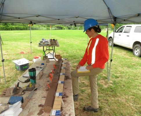
7 Reconnaissance


8 Improve our understanding of lateglacial history Verify existing surficial mapping (identify problem areas) Log exposures Auger and probe. Meet potential partners


9 Product: Summary Report Field descriptions Preliminary interpretation of landform-sediment assemblages Compilation of existing mapping Summary logs
10 Usage and Feedback Traditional view is that nobody reads them. Consultants and Conservation Authorities See where we are starting new projects and get routine updates. Used as a source for baseline understanding of the geology in a given area. In recent years these reports have been completed on a finer-scale than the regional Quaternary geology reports previously used to understand glacial history. No one has much knowledge of summary articles. Their existence is poorly known and are generally viewed as a flag that work is on-going. Internal Get it down before you forget!


11


12 Dealing with data Acquire data Standardize QUALITY!!!! Subsurface database is released as part of the final groundwater resources study

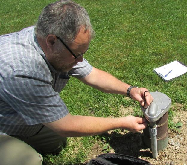
13


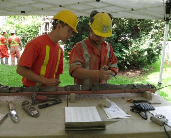
14 Ground-based gravity surveys Target areas with known or suspected buried bedrock valleys Guide drilling and monitoring well targets


15 Seismic surveys Collaboration with the GSC Continuous data Mixed results Up to 200 m depth penetration Airborne Time-Domain Electromagnetics Continuous data Transmitter flown 30-40m above ground (prepare for phone calls!) Depth penetration of up to 200 m Cultural interference is a huge problem
 Geophysical datasets Databases")

16 Products Lots of maps (.pdf) Geophysical datasets Databases Grids Survey lines and/or stations Images Contours Logistics and processing reports
17 Usage and Feedback Consulting Companies Data is seen as contributing to the overall understanding of the area. Geophysical data outlining the buried valleys is very useful in modelling studies. Conservation Authorities I don t think we have the computing power to use the geophysical tools. Internal Most of the geophysical surveys are designed to help find buried bedrock valleys before we drill (gravity surveys) or improve our understanding of surfaces. Municipal Engineers Used results of a gravity survey to check on some dodgy drill logs.

18

19


20 Monitoring wells Collaboration with municipal and conservation authority partners We provide the hole, they install the well Downhole geophysics Collaboration with the GSC Determine seismic velocities of lithological units (convert profiles to true depths) Fingerprint tills


21 Product: Summary Report Hot off the drill field descriptions Preliminary interpretations Summary logs Text and graphics (.pdf)
22 Usage and Feedback Conservation Authorities Great, thank you. When do we get your interpretations? Do you keep track of fractures? Consulting Companies Good morning Abigail. I just downloaded your latest summary and wondered if I could run something by you.. Internal Take a deep breath and THINK

 Graphic borehole")
23 Product: Interactive Borehole Data Release Index map (.pdf) Graphic borehole log (.pdf)


")
24 Graphic borehole logs are linked to Written logs (.pdf) Analytical results database (.mdb) spreadsheet (.xls) Photos (.jpg)
25 Usage and Feedback Conservation Authorities We use the logs for holes with monitoring wells. I don t need the details, just show me the aquifers! Consulting Companies I like to see the detailed logs so I can be confident in your interpretations (and summary logs). We use the boreholes as golden spikes to extrapolate the geologic units outwards. Particularly useful as you drill in areas with little or only poor quality data. Saves us (clients) money as we don t have to drill. Only useful if boreholes are close to a site or area of interest this rarely appears to be the case Downhole geophysics isn t of much interest Engineer Asked for additional parameters (numbers make them happy) Other ministries Soil scientists like the way the drill data is displayed.

26 Product: New Interactive Borehole Map Project information Conceptual model Maps Slideshow Graphic logs Printable maps
 Links to database (.mdb,.xls) GIS project (.")
27 Distribution of hydrostratigraphic units Clickable map (.pdf) Links to database (.mdb,.xls) GIS project (.mxd)
 Links to database (.mdb,.")
28 Borehole map Interactive (clickable) map (.pdf) Links to database (.mdb,.xls) Link to printable borehole log (.pdf)
 and spreadsheet (.")
29 Graphic logs View on screen or print Not everyone needs / wants the detailed version Database (.mdb) and spreadsheet (.xls) contain depth information
")
30 Printable maps Full and cropped versions (.pdf)
31 Usage and Feedback Conservation Authorities We are using your new map to try and figure out which aquifer our monitoring wells are screened in. Other ministries Our GIS staff like the drill log layouts Envy! We had a request to train their support staff in creating a similar product. Internal I used the borehole map as a quick reference tool while modelling. I used spatial distribution map to quickly see which boreholes to reference during the report writing stage.


32 Plot borehole traces Add picks Create 3-D wireframe surfaces Fill spaces with blocks
 Synthesis and interpretation of modelled units Discussion of aquifer vulnerability and")

33 Report Executive summary Regional setting Construction of a 3-D geologic model (the abbreviated version) Synthesis and interpretation of modelled units Discussion of aquifer vulnerability and recharge Explanatory notes for accompanying datasets and products Appendices Detailed discussion of data acquisition Detailed discussion of modelling protocols Outputs and products including links to previous releases


 Interpreted")
34 Synthesis and interpretation - discussion of modelled units Location, thickness, structural contour Stratigraphic context, age Sediment characteristics (range in grain sizes, trends) Interpreted depositional environment

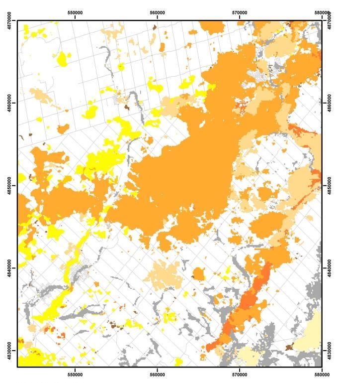


35 Aquifer vulnerability and recharge Depth to first aquifer Aquifer ID Elevation
36 Usage and Feedback Consulting Companies A present in a present in a present Saved us a lot of time and effort (money) Stratigraphic interpretations are used to construct our conceptual model We rely on your geologic information and interpretations It gives the wrong impression to use the term aquifer in the unsaturated zones. We don t need you to focus on hydrogeologic interpretations. That s our job. Just make sure you give us detailed GEOLOGIC interpretations! Conservation Authorities Suspiciously silent on the topic General Work and products are regarded as being of high scientific quality by those in other government agencies and the private sector
 Subsurface database Location, formation and 3-D picks tables Database (.")
37 Technical Products output files Continuous and discontinuous surfaces X, Y, and Z coordinates on a 100 m grid Designed for easy import into groundwater modelling software Comma-delimited data files (.csv) Subsurface database Location, formation and 3-D picks tables Database (.mdb) Too big for a spreadsheet Zzzzzzzzzzz.
38 Usage and Feedback Surfaces Used as a foundation for our flow models Most useful in the deep overburden where our information is lacking. We need you to model aquifers where monitoring wells are screened. Cost benefits are substantial in both the short and longer terms. An excellent starting point. I get really annoyed when people describe early efforts as crap. We just need to be able to tweak the model. Use the model, but add local refinement to fit our borehole data. This highlights a major weakness in the process we don t get access to most consultant s data so our models are inaccurate in the very places they are most important. Obvious???? One would have thought so.

39 Classic Example of the Merged Geologically accurate and streamlined the modelling process Unfortunately Was very difficult to use as an input for flow models Required extra processing Providing the clipping surface would have resolved most of the problems Even more unfortunately The consultants didn t pick up the phone and ask for clipping surface, even when another major client suggested it.

40 GIS grids GIS Raster datasets Structural contours, isopach and aquifer vulnerability maps
41 Usage and Feedback Consulting Companies Use the maps and grids to help build our hydrostratigraphic model Import the grids into flow modelling software Some have used ALL our layers, other merge the layers Internal Display grids from multiple project areas to improve our interpretation of the Quaternary history The grids facilitate the report writing process


42 Non-technical Products Section viewer Displays cross-sections along user defined lines Save then view in Google Earth Microsoft Virtual Earth executable (SectionViewer.exe)
 and graphic (.")
43 Google Earth as a viewing platform Eliminates need for clients to have expensive software Isopach and structural contour maps Excerpts from seamless geology maps Aquifer vulnerability maps Google Earth (.kml,.kmz) and graphic (.png) files

44 Query the standardized legacy database View new high quality data (perhaps the SUMMARY lithology would be better)

45 Import previously saved cross-sections Allows user-defined fence diagrams
46 Usage and Feedback Conservation Authorities Use the section viewer to determine which aquifer their monitoring wells are screened in. I mostly use the online Google Earth OGS tool for hydrostratigraphic and geological purposes along with the various layers associated with it. Can you resend me the link? Other Feedback It looks great, but what am I supposed to DO with it?
47 OVERALL ASSESSMENT Summary reports and borehole releases Mixed reviews some can t wait, others barely register their existence. Valley delineation is used, the rest is largely ignored. Final Products This is what folks download and use as a reference and employ as a data source. My take on it Each product has a different fan group This means that we have succeeded in our mission to provide products useable by a wide range of clients. Suspect that the auditors like interim products more than our clients do.
NEW PRODUCTS AND ADVANCEMENTS IN 3-D MODELLING PROTOCOLS BASED ON STUDIES IN THICK DRIFT AREAS IN ONTARIO, CANADA
 NEW PRODUCTS AND ADVANCEMENTS IN 3-D MODELLING PROTOCOLS BASED ON STUDIES IN THICK DRIFT AREAS IN ONTARIO, CANADA Abigail K. Burt and Andrew F. Bajc Ontario Geological Survey, 933 Ramsey Lake Road, Sudbury,
Geofacets Seminar & Interactive Workshop
 Geofacets Seminar & Workshop University of Bergen Geofacets Seminar & Interactive Workshop UNIVERSITY OF BERGEN Sandra Merten Geofacets Product Manager University of Bergen, 22 March 2017 Geofacets Seminar
Harvey Thorleifson, Director, Minnesota Geological Survey. Status of geological mapping needed for groundwater protection in Minnesota
 Harvey Thorleifson, Director, Minnesota Geological Survey Status of geological mapping needed for groundwater protection in Minnesota Minnesota is located between the Dakotas and Wisconsin, north of Iowa,
A method for three-dimensional mapping, merging geologic interpretation, and GIS computation
 A method for three-dimensional mapping, merging geologic interpretation, and GIS computation Soller, David R., U.S. Geological Survey, 908 National Center, Reston, VA 20192 and Richard C. Berg, Illinois
Ground-Water Exploration in the Worthington Area of Nobles County: Summary of Seismic Data and Recent Test Drilling Results
 Ground-Water Exploration in the Worthington Area of Nobles County: Summary of Seismic Data and Recent Test Drilling Results Jim Berg and Todd Petersen Geophysicists, DNR Waters January 2000 Table of Contents
Desktop GIS for Geotechnical Engineering
 Desktop GIS for Geotechnical Engineering Satya Priya Deputy General Manager (Software) RMSI, A-7, Sector 16 NOIDA 201 301, UP, INDIA Tel: +91-120-2511102 Fax: +91-120-2510963 Email: Satya.Priya@rmsi.com
Dept. of Earth and Environmental Sciences, University of Waterloo, 200 University Ave W, Waterloo, Ontario, Canada, N2L 3G1 2
 A modelling strategy to develop a regional Quaternary geological model across rural and urban areas and administrative borders using existing geological information M. Ross 1, M. Parent 2, A. Taylor 1
Towards Seamless Interactions Between Geologic Models and Hydrogeologic Applications
 Towards Seamless Interactions Between Geologic Models and Hydrogeologic Applications Ross, M. 1, M. Parent 2, R. Martel 1, and R. Lefebvre 1 1 Institut National de la Recherche Scientifique (INRS-ETE),
Advanced processing and inversion of two AEM datasets for 3D geological modelling: the case study of Spiritwood Valley Aquifer
 Advanced processing and inversion of two AEM datasets for 3D geological modelling: the case study of Spiritwood Valley Aquifer Vincenzo Sapia, INGV, Rome, Italy Vincenzo.sapia@ingv.it Andrea Viezzoli,
3D MODELLING OF QUATERNARY DEPOSITS IN WATERLOO REGION, ONTARIO; A CASE STUDY USING DATAMINE STUDIO SOFTWARE
 3D MODELLING OF QUATERNARY DEPOSITS IN WATERLOO REGION, ONTARIO; A CASE STUDY USING DATAMINE STUDIO SOFTWARE Andrew F.Bajc 1 and Malcom J. Newton 2 1 Ontario Geological Survey, 933 Ramsey Lake Road,Sudbury,
THE DIGITAL TERRAIN MAP LIBRARY: AN EXPLORATIONIST S RESOURCE
 THE DIGITAL TERRAIN MAP LIBRARY: AN EXPLORATIONIST S RESOURCE By I.C.L. Webster, P.J. Desjardins and W.E. Kilby KEYWORDS: digital terrain maps, digital terrain stability maps, surficial geology, GIS, raster
Geophysical Exploration in Water Resources Assessment. John Mundell, P.E., L.P.G., P.G. Ryan Brumbaugh, L.P.G. Mundell & Associates, Inc.
 Geophysical Exploration in Water Resources Assessment John Mundell, P.E., L.P.G., P.G. Ryan Brumbaugh, L.P.G. Mundell & Associates, Inc. Presentation Objective Introduce the use of geophysical survey methods
Three Dimensional Modeling of Geological Parameters in Volcanic Geothermal Systems. Part I Methods and Data.
 Proceedings World Geothermal Congress 2015 Melbourne, Australia, 19-25 April 2015 Three Dimensional Modeling of Geological Parameters in Volcanic Geothermal Systems. Part I Methods and Data. Gunnlaugur
First Technical Report Geophysical experiments near Kajiado town
 First Technical Report Geophysical experiments near Kajiado town Synthesis Report of First case study within the ISGEAG VIA Water project By: Michel Groen *), Harry Rolf **), and Ammon Muiti ***) *) Acacia
Introduction. Purpose
 Introduction The Edwards Aquifer is a karst aquifer in Central Texas whose hydrogeological properties are not fully understood. This is due to exaggerated heterogeneity of properties, high anisotropy due
THE ROLE OF 3-D GEOLOGIC MODELING AND DATABASE SOLUTIONS IN THE VIRTTAANKANGAS ARTIFICIAL RECHARGE PROJECT, SOUTHWESTERN FINLAND
 THE ROLE OF 3-D GEOLOGIC MODELING AND DATABASE SOLUTIONS IN THE VIRTTAANKANGAS ARTIFICIAL RECHARGE PROJECT, SOUTHWESTERN FINLAND Artimo, A. 1, S. Saraperä 2, and I. Ylander 1 1 Turku Region Water Ltd.,
Geological control in 3D stratigraphic modeling, Oak Ridges Moraine, southern Ontario. Logan, C., Russell, H. A. J., and Sharpe, D. R.
 Geological control in 3D stratigraphic modeling, Oak Ridges Moraine, southern Ontario Logan, C., Russell, H. A. J., and Sharpe, D. R. Rationale Increasing urbanization in the Greater Toronto Area is creating
DESIGN-PHASE GEOLOGIC FRAMEWORK MODELING FOR LARGE CONSTRUCTION PROJECTS
 DESIGN-PHASE GEOLOGIC FRAMEWORK MODELING FOR LARGE CONSTRUCTION PROJECTS Christine Vilardi, P.G., C.G.W.P. (vilardcl@stvinc.com, STV Inc., New York, New York) and Todd Kincaid, Ph.D. (Hazlett-Kincaid,
Write a report (6-7 pages, double space) on some examples of Internet Applications. You can choose only ONE of the following application areas:
 on some examples of Internet Applications. You can choose only ONE of the following application areas:") UPR 6905 Internet GIS Homework 1 Yong Hong Guo September 9, 2008 Write a report (6-7 pages, double space) on some examples of Internet Applications. You can choose only ONE of the following application
UPR 6905 Internet GIS Homework 1 Yong Hong Guo September 9, 2008 Write a report (6-7 pages, double space) on some examples of Internet Applications. You can choose only ONE of the following application
3D Geoscience models and their delivery to customers
 3D Geoscience models and their delivery to customers Holger Kessler, Mike Lelliott, Dave Bridge, Jon Ford, Hans-Georg Sobisch, Steve Mathers, Simon Price, Jo Merritt, Bruce Napier & Kate Royse GSA Annual
Outline Brief Overview MapPlace Website Data Delivery & Map Themes Digital Geology
 BRITISH COLUMBIA GEOLOGICAL SURVEY Kirk Hancock Pat Desjardins Nick Massey BRITISH COLUMBIA Ministry of Energy and Mines Ward Kilby acknowledged developer of MapPlace Outline Brief Overview MapPlace Website
Geological Mapping using Geophysics
 Geological Mapping using Geophysics Pugin, A.J.M. and T.H. Larson Illinois State Geological Survey, 615 E Peabody Dr., Champaign, IL 61820; E-mail: A.J.M. Pugin at pugin@isgs.uiuc.edu Mapping Techniques.
Summary. Introduction. Theory and/or Method
 Case studies from Fort Mc Murray, Horn River basin and Manitoba displaying advances in technology, new approach and updated interpretation of AEM data for unconventional hydrocarbons and groundwater mapping
Aquifer Mapping and Characterization in southern Ontario:
 OGS-GSC Open House, Guelph March10 th, 2016 Aquifer Mapping and Characterization in southern Ontario: A Collaborative OGS GSC project 2014-2019 Hazen A.J. Russell & Andy F. Bajc Where to Find us! Workshop
Regional groundwater mapping and model
 Regional groundwater mapping and model Boyd, Dwight 1, Steve Holysh 2, and Jeff Pitcher 1 1 Grand River Conservation Authority, Canada; 2 Regional Municipality of Halton, Canada The Grand River forms one
THE NEW DNR LANDSLIDE HAZARDS PROGRAM
 THE NEW DNR LANDSLIDE HAZARDS PROGRAM Kara Jacobacci, G.I.T. Landslide Hazards Program Washington Geological Survey Washington Department of Natural Resources LEGISLATIVE FUNDING 2015 session DNR requested
National Atlas of Groundwater Dependent Ecosystems (GDE)
") National Atlas of Groundwater Dependent Ecosystems (GDE) Dr. Zaffar Sadiq Mohamed-Ghouse Executive Consultant & Practice Head-Spatial SKM, Australia zsadiq@globalskm.com Geospatial World Forum 2013, Rotterdam,
National Atlas of Groundwater Dependent Ecosystems (GDE) Dr. Zaffar Sadiq Mohamed-Ghouse Executive Consultant & Practice Head-Spatial SKM, Australia zsadiq@globalskm.com Geospatial World Forum 2013, Rotterdam,
Applied Geophysics for Environmental Site Characterization and Remediation
 Applied Geophysics for Environmental Site Characterization and Remediation MSECA Webinar September 24, 2015 John Mundell, P.E., L.P.G. Ryan Brumbaugh, L.P.G. MUNDELL & ASSOCIATES, INC. Webinar Objective
The Geology and Hydrogeology of the Spyhill Area
 The Geology and Hydrogeology of the Spyhill Area Clare North (WorleyParsons Komex) and Martin Ortiz (The City of Calgary) 2-Jul-08 Outline Background Site Location Existing Information New Work Geology
SASKATCHEWAN STRATIGRAPHY GLACIAL EXAMPLE BOULDERS IN GLACIAL DEPOSITS
 SASKATCHEWAN STRATIGRAPHY GLACIAL EXAMPLE BOULDERS IN GLACIAL DEPOSITS 51 SASKATCHEWAN STRATIGRAPHY GLACIAL SURFICIAL STRATIFIED DEPOSITS 52 SASKATCHEWAN STRATIGRAPHY GLACIAL EXAMPLE OF SEDIMENT DEPOSITION
Tools for building and delivering 3D models Perspectives by the BGS
 Tools for building and delivering 3D models Perspectives by the BGS Holger Kessler (on behalf of the 3D community of BGS) Kingsley Dunham Centre Keyworth Nottingham NG12 5GG Tel 0115 936 3100 www.bgs.ac.uk/3dg
The MapPlace Using Web-Based Mineral Exploration Data as an Environmental Tool
 The MapPlace Using Web-Based Mineral Exploration Data as an Environmental Tool David Tupper PGeo Pottinger Gaherty Environmental Consultants Ltd Ward Kilby PGeo Cal Data Ltd Larry Jones PGeo BC Ministry
Rethink GroundWater Mapping and Management Strategies for Unconventional Uydrocarbons using Airborne EM
 Rethink GroundWater Mapping and Management Strategies for Unconventional Uydrocarbons using Airborne EM Andrea Viezzoli Aarhus Geophysics Aps, Andrea.viezzoli@aarhusgeo.com Summary The need to map, extract,
STATE GEOGRAPHIC INFORMATION DATABASE
 STATE GEOGRAPHIC INFORMATION DATABASE Data Information and Knowledge Management STATE GEOGRAPHIC INFORMATION DATABASE EXECUTIVE SUMMARY Utah has developed one of the most comprehensive statewide GIS resources
GIS for the Beginner on a Budget
 GIS for the Beginner on a Budget Andre C. Bally, RLA, GIS Coordinator, Harris County Public Infrastructure Department Engineering Division This presentation, GIS for Beginners on a Budget. will briefly
Using the Stock Hydrology Tools in ArcGIS
 Using the Stock Hydrology Tools in ArcGIS This lab exercise contains a homework assignment, detailed at the bottom, which is due Wednesday, October 6th. Several hydrology tools are part of the basic ArcGIS
Bridging Subsurface Geologic Databases with Cross-Sections in GIS
 Bridging Subsurface Geologic Databases with Cross-Sections in GIS Eva E. von Thury ESRI International User Conference Padre Associates, Inc. Project Geologist / GIS Analyst June 29, 2016 Outline Introduction
European Commission STUDY ON INTERIM EVALUATION OF EUROPEAN MARINE OBSERVATION AND DATA NETWORK. Executive Summary
 European Commission STUDY ON INTERIM EVALUATION OF EUROPEAN MARINE OBSERVATION AND DATA NETWORK Executive Summary by NILOS Netherlands Institute for the Law of the Sea June 2011 Page ii Study on Interim
Geological Models for Infrastructure Design:
 Geological Models for Infrastructure Design: Reducing Geotechnical Risk and Supporting Sustainability Alan Keith Turner Emeritus Professor of Geological Engineering CSM Visiting Research Associate - British
SADA General Information
 SADA General Information Windows--based freeware designed to integrate scientific models with decision and cost analysis frameworks in a seamless, easy to use environment. Visualization/GIS Custom Analysis
Management and Sharing of Hydrologic Information of Cache County
 Geographic Information System in Water Resources CEE6440 Fall Semester 2012 Management and Sharing of Hydrologic Information of Cache County To: Dr. David Tarboton Instructor By: Tian Gan Dec.7, 2012 I.
Phase 1 Geoscientific Preliminary Assessment Southern Ontario, Sedimentary Communities
 Phase 1 Geoscientific Preliminary Assessment Southern Ontario, Sedimentary Communities Presented to: Community Liaison Committees (Brockton, Huron-Kinloss, South Bruce) March 2014 Project Description»
Linear Referencing in Boulder County, CO. Getting Started
 Linear Referencing in Boulder County, CO Getting Started 1 Authors Janie Pierre GIS Technician, Boulder County Road centerline and storm sewer geodatabases & maps John Mosher GIS Specialist, Boulder County
EXTREMELY FAST IP USED TO DELINEATE BURIED LANDFILLS. Norman R. Carlson, Cris Mauldin Mayerle, and Kenneth L. Zonge
 EXTREMELY FAST IP USED TO DELINEATE BURIED LANDFILLS Norman R. Carlson, Cris Mauldin Mayerle, and Kenneth L. Zonge Zonge Engineering and Research Organization, Inc. 3322 East Fort Lowell Road Tucson, Arizona,
Buried-valley Aquifers: Delineation and Characterization from Reflection Seismic and Core Data at Caledon East, Ontario
 Buried-valley Aquifers: Delineation and Characterization from Reflection Seismic and Core Data at Caledon East, Ontario Russell, H.A.J. 1, S.E. Pullan 1, J.A. Hunter 1, D.R. Sharpe 1, and S. Holysh 2 1
Basin Analysis Applied to Modelling Buried Valleys in the Great Lakes Basin
 EARTH SCIENCES SECTOR GENERAL INFORMATION PRODUCT 35 Basin Analysis Applied to Modelling Buried Valleys in the Great Lakes Basin Sharpe, D R; Russell, H A J 2004 Originally released as: Basin Analysis
GIS Semester Project Working With Water Well Data in Irion County, Texas
 GIS Semester Project Working With Water Well Data in Irion County, Texas Grant Hawkins Question for the Project Upon picking a random point in Irion county, Texas, to what depth would I have to drill a
HYBRID DETERMINISTIC AND STOCHASTIC HYDROSTRATIGRAPHIC MODELING OF A COMPLEX GLACIAL AQUIFER SYSTEM
 HYBRID DETERMINISTIC AND STOCHASTIC HYDROSTRATIGRAPHIC MODELING OF A COMPLEX GLACIAL AQUIFER SYSTEM Lawrence D. Lemke, Andrew L. Frahm, Lena K. Pappas Department of Geology, Wayne State University, Detroit,
How GIS can be used for improvement of literacy and CE programmes
 How GIS can be used for improvement of literacy and CE programmes Training Workshop for Myanmar Literacy Resource Center (MLRC) ( Yangon, Myanmar, 11 20 October 2000 ) Presented by U THEIN HTUT GEOCOMP
Procedure for Determining Near-Surface Pollution Sensitivity
 Procedure for Determining Near-Surface Pollution Sensitivity Minnesota Department of Natural Resources Division of Ecological and Water Resources County Geologic Atlas Program March 2014 Version 2.1 I.
Road to GIS, PSE s past, present and future
 Road to GIS, PSE s past, present and future PSE Gas Mapping History 1840 Early 1900 s Gas piping was captured in Field Books which were than converted onto Mylar maps using Pen and Ink. 1955 Washington
Metallic Mineral Exploration in Minnesota: Typical Exploration Activities. Division of Lands and Minerals Minnesota Department of Natural Resources
 Metallic Mineral Exploration in Minnesota: Typical Exploration Activities Division of Lands and Minerals Minnesota Department of Natural Resources Metallic minerals can only be mined economically where
UTAH S STATEWIDE GEOGRAPHIC INFORMATION DATABASE
 UTAH S STATEWIDE GEOGRAPHIC INFORMATION DATABASE Data Information and Knowledge Management NASCIO Awards 2009 STATE GEOGRAPHIC INFORMATION DATABASE B. EXECUTIVE SUMMARY Utah has developed one of the most
GIS Applications in Groundwater Protection /Term Paper Final Paper
 GIS Applications in Groundwater Protection /Term Paper Final Paper By Humoud W. Al-Utaibi ID #937501 For CRP 514: Introduction to GIS Term 061 13 th Offer Course Instructor: Dr. Baqer Al-Ramadan Date:
ambiguity in earth sciences IESO Geophysics Section Eddy hartantyo, Lab Geofisika FMIPA UGM
 ambiguity in earth sciences IESO Geophysics Section Eddy hartantyo, Lab Geofisika FMIPA UGM Pelatihan Tahap II IESO Teknik Geologi UGM Februari 2009 1 Introduction Photos from http://www.eegs.org/whatis/
Innovation in Geology and Earth Sciences with ArcGIS. Presented by: Mike Price Entrada/San Juan, Inc. Blaine, WA
 Innovation in Geology and Earth Sciences with ArcGIS Presented by: Mike Price Entrada/San Juan, Inc. Blaine, WA Organization Overview Entrada/San Juan is a GIS consultancy based in Blaine, WA Industries
1.1 What is Site Fingerprinting?
 Site Fingerprinting Utilizing GIS/GPS Technology 1.1 What is Site Fingerprinting? Site fingerprinting is a planning tool used to design communities where protection of natural resources is the primary
COURSE OUTLINE GEOL204 MINING COMPUTING 3 CREDITS
 COURSE OUTLINE GEOL204 MINING COMPUTING 3 CREDITS PREPARED BY: Joel Cubley, Instructor DATE: June 1, 2018 APPROVED BY: Margaret Dumkee, Dean DATE: June 1, 2018 APPROVED BY ACADEMIC COUNCIL: May 2014 GEOL204
GeothermEx, Inc. GEOTHERMAL RESERVOIR ASSESSMENT METHODOLOGY FOR THE SCIENTIFIC OBSERVATION HOLE PROGRAM, KILAUEA EAST RIFT ZONE, HAWAII TASK 1 REPORT
 (415) 527 9876 CABLE ADDRESS- GEOTHERMEX TELEX 709152 STEAM UD FAX (415) 527-8164 Geotherm Ex, Inc. RICHMOND. CALIFORNIA 94804-5829 GEOTHERMAL RESERVOIR ASSESSMENT METHODOLOGY FOR THE SCIENTIFIC OBSERVATION
POTASH DRAGON CHILE GEOPHYSICAL SURVEY TRANSIENT ELECTROMAGNETIC (TEM) METHOD. LLAMARA and SOLIDA PROJECTS SALAR DE LLAMARA, IQUIQUE, REGION I, CHILE
 METHOD. LLAMARA and SOLIDA PROJECTS SALAR DE LLAMARA, IQUIQUE, REGION I, CHILE") POTASH DRAGON CHILE GEOPHYSICAL SURVEY TRANSIENT ELECTROMAGNETIC (TEM) METHOD LLAMARA and SOLIDA PROJECTS SALAR DE LLAMARA, IQUIQUE, REGION I, CHILE OCTOBER 2012 CONTENT Page I INTRODUCTION 1 II FIELD
POTASH DRAGON CHILE GEOPHYSICAL SURVEY TRANSIENT ELECTROMAGNETIC (TEM) METHOD LLAMARA and SOLIDA PROJECTS SALAR DE LLAMARA, IQUIQUE, REGION I, CHILE OCTOBER 2012 CONTENT Page I INTRODUCTION 1 II FIELD
Ørsted. Flexible reporting solutions to drive a clean energy agenda
 Ørsted Flexible reporting solutions to drive a clean energy agenda Ørsted: A flexible reporting solution to drive a clean energy agenda Renewable energy company Ørsted relies on having a corporate reporting
indigeo Consultants Pvt Ltd Geophysical Surveys Geological Surveys GIS & Data Solutions Image Processing indigeo Company Profile, Page 1
 indigeo Consultants Pvt Ltd Geophysical Surveys Geological Surveys GIS & Data Solutions Image Processing MM Corner, 3 rd Floor #58, Banaswadi Main Road Bangalore 560033 INDIA Ph: +91 80 41638310 Mob: +91
Louisiana Transportation Engineering Conference. Monday, February 12, 2007
 Louisiana Transportation Engineering Conference Monday, February 12, 2007 Agenda Project Background Goal of EIS Why Use GIS? What is GIS? How used on this Project Other site selection tools I-69 Corridor
Structure contours on Bone Spring Formation (Lower Permian), Delaware Basin
, Delaware Basin") Structure contours on Bone Spring Formation (Lower Permian), Delaware Basin By Ronald F. Broadhead and Lewis Gillard New Mexico Bureau of Geology and Mineral Resources, a division of New Mexico Tech, Socorro
Structure contours on Bone Spring Formation (Lower Permian), Delaware Basin By Ronald F. Broadhead and Lewis Gillard New Mexico Bureau of Geology and Mineral Resources, a division of New Mexico Tech, Socorro
Geoscience Databases. How did we get where we are?
 Geoscience Databases The 800 pound gorilla in the room of the modern digital world How did we get where we are? What are some of the issues in existing data? Obviously bad data (e.g. typos) Subtle and
4.11 Groundwater model
 4.11 Groundwater model 4.11 Groundwater model 4.11.1 Introduction and objectives Groundwater models have the potential to make important contributions in the mapping and characterisation of buried valleys.
MRD 207 METADATA DETAIL PAGE
 MRD 207 METADATA DETAIL PAGE The following represents the Basic description of an information holding. To obtain more information about this holding, see the section named Contacts. GENERAL INFORMATION
Our Services. What We Do. How We Can Help. Contact us today: January (0)
") Listening and Understanding to Optimize our Efficiency Our Experience and Knowledge to Work for You Tailor-made Solutions to Meet your Needs Our Challenge is You Success What We Do Our Services GeoViz
Listening and Understanding to Optimize our Efficiency Our Experience and Knowledge to Work for You Tailor-made Solutions to Meet your Needs Our Challenge is You Success What We Do Our Services GeoViz
MineScape Geological modelling, mine planning and design
 INTELLIGENT MINING SOLUTIONS MineScape Geological modelling, mine planning and design Specifically developed to meet the mining industry s rigorous demands, MineScape is used at more than 200 of the world
Classification of Erosion Susceptibility
 GEO327G: GIS & GPS Applications in Earth Sciences Classification of Erosion Susceptibility Denali National Park, Alaska Zehao Xue 12 3 2015 2 TABLE OF CONTENTS 1 Abstract... 3 2 Introduction... 3 2.1 Universal
DGS Digital Geologic Information Resource (DGIR) User Guide
 User Guide") DGS Digital Geologic Information Resource (DGIR) User Guide Developed by the Delaware Geological Survey. Revised January 2012. TABLE OF CONTENTS I. INTRODUCTION II. DGIR LAYOUT III. TOOLBARS IV. USING
DGS Digital Geologic Information Resource (DGIR) User Guide Developed by the Delaware Geological Survey. Revised January 2012. TABLE OF CONTENTS I. INTRODUCTION II. DGIR LAYOUT III. TOOLBARS IV. USING
Pasco project ground magnetics
 Pasco project ground magnetics Survey information Magnetic results Comments Conclusions General data information 13 June 2017 Piura Trujillo Lima Pasco Cusco Arequipa Survey information General geographic
Structure contours on Abo Formation (Lower Permian) Northwest Shelf of Permian Basin
 Northwest Shelf of Permian Basin") Structure contours on Abo Formation (Lower Permian) Northwest Shelf of Permian Basin By Ronald F. Broadhead 1, Lewis Gillard 1, and Nilay Engin 2 1 New Mexico Bureau of Geology and Mineral Resources, a
Structure contours on Abo Formation (Lower Permian) Northwest Shelf of Permian Basin By Ronald F. Broadhead 1, Lewis Gillard 1, and Nilay Engin 2 1 New Mexico Bureau of Geology and Mineral Resources, a
Instructional Objectives
 GE 6477 DISCONTINUOUS ROCK 8. Fracture Detection Dr. Norbert H. Maerz Missouri University of Science and Technology (573) 341-6714 norbert@mst.edu Instructional Objectives 1. List the advantages and disadvantages
CHALLENGES WITH FOREIGN DATA FORMATS & GEOLOGICAL CONFIDENCE
 CHALLENGES WITH FOREIGN DATA FORMATS & GEOLOGICAL CONFIDENCE Some Case Study Examples from Russia and Central Asia Grant van Heerden, Pr.Sci.Nat. Nick Ryan, CP(Geo) PRESENTATION OVERVIEW The Concept of
Among various open-source GIS programs, QGIS can be the best suitable option which can be used across partners for reasons outlined below.
 Comparison of Geographic Information Systems (GIS) software As of January 2018, WHO has reached an agreement with ESRI (an international supplier of GIS software) for an unlimited use of ArcGIS Desktop
Koenji. Using ARCGIS Online to explore a place
 Koenji Using ARCGIS Online to explore a place ArcGIS Online is a GIS program that can be opened at http://www.arcgis.com/home/ You can click on Sign-up now or Make a map to get started. It is free to use
HR Diagram of Globular Cluster Messier 80 Using Hubble Space Telescope Data
 Jason Kendall, William Paterson University, Department of Physics HR Diagram of Globular Cluster Messier 80 Using Hubble Space Telescope Data Background Purpose: HR Diagrams are central to understanding
Big data in the Geoscience: A portal to physical properties Andrew Kingdon, Mark Fellgett and Martin Nayembil
 Big data in the Geoscience: A portal to physical properties Andrew Kingdon, Mark Fellgett and Martin Nayembil British Geological Survey, Keyworth, Nottingham, NG12 5GG, aki@bgs.ac.uk Geosciences were early
Training the Next Generation of Geoscientists to Solve Realworld Environmental Problems using Advanced Techniques: Year Two Report
 Illinois State Geological Survey 615 E. Peabody Dr. Champaign, IL 61820 Training the Next Generation of Geoscientists to Solve Realworld Environmental Problems using Advanced Techniques: Year Two Report
GeoWEPP Tutorial Appendix
 GeoWEPP Tutorial Appendix Chris S. Renschler University at Buffalo - The State University of New York Department of Geography, 116 Wilkeson Quad Buffalo, New York 14261, USA Prepared for use at the WEPP/GeoWEPP
Core Description, Stratigraphic Correlation, and Mapping of Pennsylvanian Strata in the Appalachians
 Core Description, Stratigraphic Correlation, and Mapping of Pennsylvanian Strata in the Appalachians The remaining laboratory sessions for the semester will be collected into a series of exercises designed
Assessing Groundwater Vulnerability and Contaminant Pathways at MCAS Beaufort, SC
 Assessing Groundwater Vulnerability and Contaminant Pathways at MCAS Beaufort, SC James M. Rine, John M. Shafer, Elzbieta Covington Abstract A project to assess the vulnerability of groundwater resources
SYMBOLIC INTERACTIONISM: AN INTRODUCTION, AN INTERPRETATION, AN INTEGRATION: 10TH (TENTH) EDITION BY JOEL M. CHARON
 EDITION BY JOEL M. CHARON") Read Online and Download Ebook SYMBOLIC INTERACTIONISM: AN INTRODUCTION, AN INTERPRETATION, AN INTEGRATION: 10TH (TENTH) EDITION BY JOEL M. CHARON DOWNLOAD EBOOK : SYMBOLIC INTERACTIONISM: AN INTRODUCTION,
Read Online and Download Ebook SYMBOLIC INTERACTIONISM: AN INTRODUCTION, AN INTERPRETATION, AN INTEGRATION: 10TH (TENTH) EDITION BY JOEL M. CHARON DOWNLOAD EBOOK : SYMBOLIC INTERACTIONISM: AN INTRODUCTION,
Source Protection Zones. National Dataset User Guide
 Source Protection Zones National Dataset User Guide Version 1.1.4 20 th Jan 2006 1 Contents 1.0 Record of amendment...3 2.0 Introduction...4 2.1 Description of the SPZ dataset...4 2.1.1 Definition of the
A Temporal Hydrologic Database for Rapidly Changing Landscapes
 A Temporal Hydrologic Database for Rapidly Changing Landscapes Using Mt. St. Helens in Washington as a Pilot Site Adam Mosbrucker Geog 575 BACKGROUND: Client / User U.S. Geological Survey Cascades Volcano
Drillworks. DecisionSpace Geomechanics DATA SHEET
 DATA SHEET Drillworks overview DecisionSpace Geomechanics Key features Pre-drill, real-time, and post-drill analyses are all easily performed in one application using the latest data from across the field
GPR AS A COST EFFECTIVE BEDROCK MAPPING TOOL FOR LARGE AREAS. Abstract
 GPR AS A COST EFFECTIVE BEDROCK MAPPING TOOL FOR LARGE AREAS Dr. Jutta L. Hager, Hager GeoScience, Inc., Waltham, MA Mario Carnevale, Hager GeoScience, Inc., Waltham, MA Abstract Hager GeoScience, Inc.
Digital Tax Maps Westport Island Project Summary
 Digital Tax Maps Westport Island Project Summary Presented to the: Mid-Coast Regional Planning Commission Creating GIS-Based Digital Tax Maps And Linked Assessment Records For Small Towns on a Budget Dennis
Geofacets EDUCATION & RESEARCH
 EDUCATION & RESEARCH Geofacets In academic institutions, geoscience departments are tasked with producing high-quality research, instilling best practice research principles in students, and preparing
Watershed Sciences 4930 & 6920 GEOGRAPHIC INFORMATION SYSTEMS
 PURPOSE OF TODAY S LECTURE: Watershed Sciences 4930 & 6920 GEOGRAPHIC INFORMATION SYSTEMS WEEK ONE Lecture 1 Introduction to Course & Review of Maps Joe Wheaton Introduction to Course & Review of Maps
Mineral Exploration Using GIS
 King Fahad University of Petroleum and Minerals City and Regional Planning Department CRP 514: Introduction to GIS Term 112 Mineral Exploration Using GIS Term paper presentation By Mutasim Osman ID # g201105050
Tu Olym 01 Quantitative Depth to Bedrock Extraction from AEM Data
 Tu Olym 01 Quantitative Depth to Bedrock Extraction from AEM Data H. Anschütz (NGI), C. Christensen (Queen's University) & A.A. Pfaffhuber* (NGI) SUMMARY A new road segment is being planned northeast of
DK 1 Sunds WP 5. SUNDS - Groundwater flooding and 3D geological modelling
 SUNDS - Groundwater flooding and 3D geological modelling Sunds overview Timeline and activities 2017 2018 Workshop case at the TopSoil partner meeting i Brügge in september 2017 The Challenges + High groundwater
DENR s Oil and Gas Initiative. Legislative briefing March 7, 2011 by DENR s Geological Survey Program
 DENR s Oil and Gas Initiative Legislative briefing March 7, 2011 by DENR s Geological Survey Program South Dakota DOES have exploration for and production of oil and gas Taken from http://denr.sd.gov/des/og/producti.aspx
The Canadian Ceoscience Knowledge Network. - A Collaborative Effort for Unified Access to Ceoscience Data
 The Canadian Ceoscience Knowledge Network - A Collaborative Effort for Unified Access to Ceoscience Data The Canadian Geoscience Knowledge Network A Collaborative Effort for Unified Access to Geoscience
GERSVIEW: A New Database for Web Mapping
 GERSVIEW: A New Database for Web Mapping William J. Hernández, M.S. Graduate Student Department of Marine Sciences-UPRM Fernando Gilbes, Ph.D. Associate Professor Department of Geology-UPRM Overview Introduction
Outline. What is MapPlace? MapPlace Toolbar & PopUp Menu. Geology Themes 1:5M 1:1M BCGS 1:250,000. Terranes
 Outline BRITISH COLUMBIA Overview and Explore MapPlace Website Data Delivery & Map Themes Data Sources & Updates Feature Topics New Data & Maps New MINFILE Online Exploration Assistant with Image Analysis
BCGQ Mission Statement. Acquire new geoscientific knowledge in Québec within a sustainable development perspective of our mineral resources.
 BCGQ Mission Statement Acquire new geoscientific knowledge in Québec within a sustainable development perspective of our mineral resources. Financial Resources Natural Resources Fund, Mining Heritage Section
Applying Seismic Refraction Method in Depicting Geological Contact at Bukit Bunuh, Lenggong, Perak, Malaysia
 2012 International Conference on Geological and Environmental Sciences IPCBEE vol.3 6(2012) (2012)IACSIT Press, Singapoore Applying Seismic Refraction Method in Depicting Geological Contact at Bukit Bunuh,