National Atlas of Groundwater Dependent Ecosystems (GDE)
|
|
|
- Clarence Rogers
- 5 years ago
- Views:
Transcription
 Dr.")

1 National Atlas of Groundwater Dependent Ecosystems (GDE) Dr. Zaffar Sadiq Mohamed-Ghouse Executive Consultant & Practice Head-Spatial SKM, Australia Geospatial World Forum 2013, Rotterdam, 15 May 2013.
2 Acknowledgement Australian National Water Commission (NWC) Australian Bureau of Meteorology (BoM) Commonwealth Scientific Industrial Research Organisation (CSIRO) Cohga, Pty Ltd, Australia Jurisdictions (State Governments, Groundwater Departments)
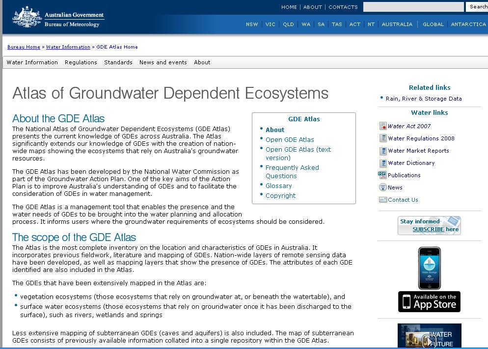
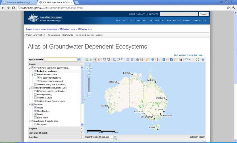
3 Background The National Water Commission (NWC) engaged SKM to develop the GDE Atlas to address a knowledge gap in the understanding and management of groundwater dependant ecosystems (GDEs) across Australia. The primary aim of the GDE Atlas was to create a consistent, nationwide inventory of GDEs in the form of web-based tool (Developed on Open Source platform) displaying ecological and hydrogeological information on GDEs. It is an important tool to help bring the identification and assessment The GDE Atlas comprises maps that show the location of both known and potential GDEs across Australia, as well as ecological and hydrogeological information for each GDE. The database containing the GDE mapping is hosted by the Bureau of Meteorology (BOM) and is accessible through their website (
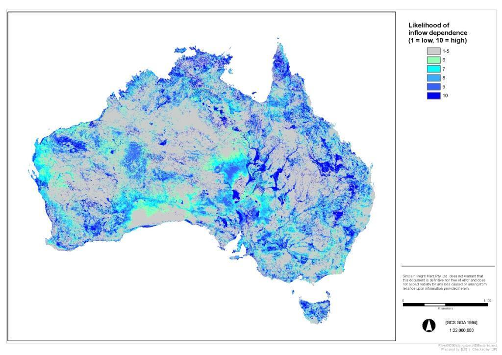
4 WHAT THE ATLAS SHOWS Series of spatial layers showing potential for groundwater interaction Known GDEs Ecosystems are classified into 2 general types: Ecosystems that rely on SUBSURFACE presence of groundwater (vegetation) Ecosystems that rely on the SURFACE expression of groundwater (rivers, wetlands, springs)
5 SPATIAL LAYERS ARE: ID layers Landscapes that use water in addition to rain IDE layers Ecosystems that use water in addition to rain GDE layers Ecosystems that potentially use groundwater


6 Example: Northern Australia using pide Riparian vegetation, surrounded by non vegetated flood plain Step 1 MODIS pide Step 3 Landsat NDVI angle analysis Classify the greenness of landscapes as slow changing and no change Step 2 Normalised MODIS Likelihood 1 to 10 Normalise to highlight large landscape features such as wetlands and fringing vegetation of floodplains. Areas of bare soil or rock are identified by having a very low likelihood Step 4 Landsat derived Forest Determine where MODIS is used in preference to Landsat outputs.
 and final layer scale 6 to 10 (right) Delineates active vegetation and areas of surface water")

7 Step 5 MODIS and Landsat ouputs combined to create the final ID layer, interim layer - scale 1 to 10 (left) and final layer scale 6 to 10 (right) Delineates active vegetation and areas of surface water inundation. The finer resolution of the Landsat data enables small scale features such as riparian vegetation within floodplains to be highlighted that was not delineated by the MODIS data (areas of blue surrounded by red).
8 Remote Sensing Layer
9 ID Layer
10 IDE Layer (vegetation)
11 IDE Layer (rivers, wetlands, springs)
12 Process for identifying GDEs Remote sensing Task 4 Identifying GDEs Task 5 MODIS Landsat Feature Layers GIS Analysis rules GIS Analysis datasets Gridded Remote Sensing Layer (likelihood pixels 1 to 10) Gridded ID Layer (all pixels of likelihood >5) Polygon IDE Layer (all polygons of likelihood >5) Potential GDE Layers (all polygons of probability >5 AND with supporting GIS data) Shows likelihood of inflow dependence Shows inflow dependent landscapes Shows inflow dependent ecosystems Derived GDE layers, showing: - GDE potential (H/M/L) GDE derived in previous studies GDEs identified in previous study: - Field validated - Desk top
13

14
15
16 Data Management Development of a robust spatial data model Scripting and programming for data loads and quality checks for data integrity Metadata population at feature level and global level ISO 19115:2003 standard Development of classes based on database attributes to support cartography Build topological consistency across GDE and Reference layers Develop spatial indexes to enable fast searches for spatial attributes Compilation of heterogeneous and varying data quality into one consistent layer across the nation Package the data downloads river basin wise as zip files Fine tune and optimisation of database and web Updatability process for the atlas
17 Groundwater Dependent Ecosystems tables (Vector) Lookup tables GDE_SUBSURFACE Reference tables REFERENCE_SS_LINK GW_RELATIVITY_LUT GDE_SURFACE REFERENCE_SU_LINK REFERENCE_LUT SALINITY_LUT GDE_AQ_CAVE REFERENCE_AC_LINK WATER_REGIME_LUT SOIL_SUBSTRATE_LUT RESID_TIME_LUT AQUIFER_GEOFABRIC_LUT SATURATION_LUT STATE_LUT IDE_LUT G_MORPHOLOGY_LUT LANDSCAPE_LUT Aquifer link tables DRAIN_BASIN_LUT CONDITION_LUT ECOSYSTEM_CLASS_LUT GW_FLOW_LUT AQUIFER_AC_LINK AQUIFER_SU_LINK AQUIFER_SS_LINK HYDRO_CAPTZONE_LUT RAINFALL_LUT ECOSYSTEM_TYPE_LUT LANDUSE_LUT AQUIFER_GW_FLOW_LUT AQUIFER_GEOLOGY_LUT AQUIFER_NAME_LUT AQUIFER_POROUS_LUT SPATIAL_CONNECT_LUT GW_DEPENDENCY_LUT BIOREG_LUT EHZ_LUT ECOSYSTEM_OCCUR_LUT GMA_LUT PERM_CONNECT_LUT GW_REQUIREMENT_LUT AQUIFER_SOURCETYPE_L UT GW_SALINITY_LUT GW_RECHARGE_LUT GW_PH_LUT Expected reference datasets (National) (Vector) (Raster) CLIMATE_ZONES BIOGREGIONS ECO_HYDROGOLOGICAL_Z ONES STATE_BORDERS CATCHMENTS PLACENAMES GW_AQUIFERS INFLOW_DEPENDENT_ECO SYTEM WATERCOURSE_LINES EXT_M_VEG_NVIS RIVER_BASINS SURFACE_GEOLOGY GEOMORPHOLOGY GW_PROVINCES ROADS COAST_LINES WATERCOURSE_AREAS GW_FLOW_SYSTEMS
18 Web Development Built on Linux, Postgresql/PostGIS, Map Server, Open Layers, WEAVE Conducted web based user survey Conducted user requirement workshop and acceptance workshop (Virtual) Scripting and programming for integrating SDM to web atlas Web based cartography Development of text based web site to comply with the Australian Government Standard on Web Content Accessibility Guidelines (WCAG) 2.0 Developed Atlas product adhering to the contract requirements clause to follow Australian Government standards: W3C, OGC, WCAG 2.0, ISO Development of web based Help System, FAQ and Glossary Regular meetings with BoM to ensure the delivery meets the BoM Standards
19
20 Tools

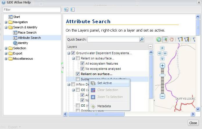
21 Spatial Identify Tool

22 Click to Select

23 Report Tool

24 Zoom to Location Tool

25 Download Tool

26 GDE Tips Tool

27 Maximise Interface Tool
28 Help Tool
29 Uses of the GDE Atlas The health of GDEs is a significant concern for water managers and needs to be better considered in water planning processes The GDE Atlas is a critical resource to fill the knowledge gap of where GDEs occur, and is a key tool for enabling the water requirements of GDEs to be considered in planning processes Importantly, the Atlas will underpin future management decisions and help to protect vulnerable environmental assets. Interprets and synthesises a lot of information Remote sensing, ID layer, IDE layers For further interpretation, e.g. Plantation water use Potential water use where ecosystems have not been mapped (e.g. NT)
30 Uses of the GDE Atlas GDE layers Can be used for further interpretation: Add additional detail to smaller areas Inform further studies. Where is more detailed information required? Can be used as is: Risk prioritisation - where is integrated management a higher priority? Inform on broad scale vegetation water requirements Relative importance of groundwater in surface water ecosystems Identifies springs Risks to GDEs from Groundwater development
31 User Feedback Impressed with the Atlas Functionality Highly interactive More than expected functions in the Atlas Good speed Nice free text search on location Download of data
32 Way Forward Build a tool to allow users to tag field photos of GDEs / Share local information about GDEs Build Web Mapping Service (WMS) to allow users to load GDE information as reference layer in their local computer. Build graphical user interface to update and modify GDE data. Build specific application tools on top of GDE atlas for Mining, Groundwater and Surface water, Planning domains... Build field data capture application through GPS enabled mobile mapping technology to update the GDEs positional accuracy and relevant field information
33 Summary Project delivered on time and budget for $4.6 USD Million in 18 months. Development of a robust spatial data model to support 4 million GDE features on an open source web mapping platform. Development of new algorithms to map Evapo Transpiration (ET) using 10 years of temporal remote sensing data which was used to create the remote sensing layers covering entire Australia termed as Inflow Dependent Ecosystems. Scripting and programming for data loads and quality checks for data integrity
34 Summary... Metadata population at feature level and global level ISO 19115:2003 standard Development of classes based on database attributes to support cartography Build topological consistency across GDE and Reference layers Develop spatial indexes to enable fast searches for spatial attributes Compilation of heterogeneous and varying data quality into one consistent layer across the nation Package the data downloads river basin wise as shape files for use in local GIS and.kmz for use in Google Earth Fine tune and optimisation of database and web
35 Summary... Updatability process for the atlas Built on Linux, Postgresql/PostGIS, Map Server, Open Layers, WEAVE Conducted web based user survey Conducted user requirement workshop and acceptance workshop (Virtual) Scripting and programming for integrating SDM to web atlas Web based cartography to support colour blind users
36 The National Atlas of Groundwater Ecosystems demonstrates an innovative approach to a national problem, spatially enabling and collating numerous data sets into a cohesive and comprehensible solution Thank You! zsadiq@globalskm.com
Improving groundwater governance using spatial intelligence
 Improving groundwater governance using spatial intelligence By Dr Zaffar Sadiq Mohamed-Ghouse Practice Head, Spatial Information Sinclair Knight Merz, Australia www.globalskm.com Geospatial World Forum
Updating the Atlas of Groundwater Dependent Ecosystems in response to user demand
 22nd International Congress on Modelling and Simulation, Hobart, Tasmania, Australia, 3 to 8 December 2017 mssanz.org.au/modsim2017 Updating the Atlas of Groundwater Dependent Ecosystems in response to
Spatial Data Management of Bio Regional Assessments Phase 1 for Coal Seam Gas Challenges and Opportunities
 Spatial Data Management of Bio Regional Assessments Phase 1 for Coal Seam Gas Challenges and Opportunities By Dr Zaffar Sadiq Mohamed-Ghouse Principal Consultant, Spatial & IT, GHD zaffar.sadiq@ghd.com
Statewide wetland geospatial inventory update
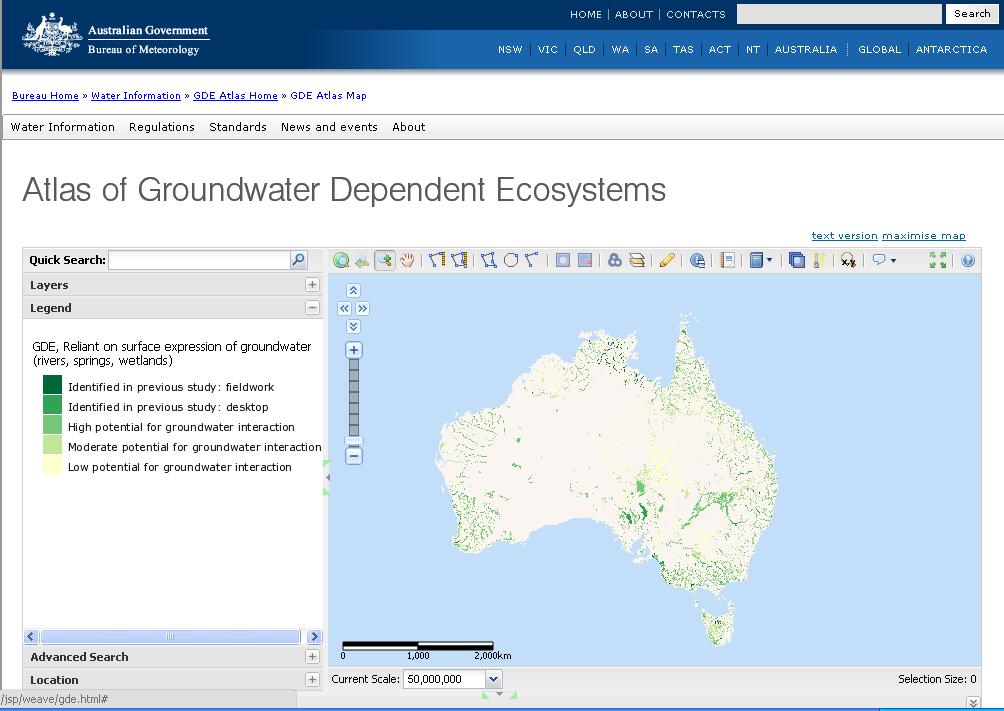
 Statewide wetland geospatial inventory update Factsheet 1: Outcomes from the statewide wetland geospatial inventory update 1 Introduction In 2011 the Victorian Department of Environment and Primary Industries
Dynamic Land Cover Dataset Product Description
 Dynamic Land Cover Dataset Product Description V1.0 27 May 2014 D2014-40362 Unclassified Table of Contents Document History... 3 A Summary Description... 4 Sheet A.1 Definition and Usage... 4 Sheet A.2
EBA Engineering Consultants Ltd. Creating and Delivering Better Solutions
 EBA Engineering Consultants Ltd. Creating and Delivering Better Solutions ENHANCING THE CAPABILITY OF ECOSYSTEM MAPPING TO SUPPORT ADAPTIVE FOREST MANAGEMENT Prepared by: EBA ENGINEERING CONSULTANTS LTD.
A Help Guide for Using gssurgo to Find Potential Wetland Soil Landscapes
 A Help Guide for Using gssurgo to Find Potential Wetland Soil Landscapes Wetland Mapping Consortium Webinar September 17, 2014 Dr. John M. Galbraith Crop & Soil Environmental Sciences Virginia Tech Wetland
Using OGC standards to improve the common
 Using OGC standards to improve the common operational picture Abstract A "Common Operational Picture", or a, is a single identical display of relevant operational information shared by many users. The
Louisiana Transportation Engineering Conference. Monday, February 12, 2007
 Louisiana Transportation Engineering Conference Monday, February 12, 2007 Agenda Project Background Goal of EIS Why Use GIS? What is GIS? How used on this Project Other site selection tools I-69 Corridor
GOVERNMENT OF NEPAL MINISTRY OF IRRIGATION GROUND WATER RESOURCES DEVELOPMENT BOARD BABARMAHAL, KATHMANDU, NEPAL
 GOVERNMENT OF NEPAL MINISTRY OF IRRIGATION GROUND WATER RESOURCES DEVELOPMENT BOARD BABARMAHAL, KATHMANDU, NEPAL GIS Based Updating of Groundwater Level Siraha District Final Report Submitted to Ground
Topographic Strategy National Topographic Office March 2015
 www.linz.govt.nz Topographic Strategy National Topographic Office March 2015 >> Foreword Topographic information is vital to understanding our country and its assets, and for supporting economic development.
What is CERA? Coastal Emergency Risks Assessment
 What is CERA? Coastal Emergency Risks Assessment Visualization tool using OGC standards Displays the outputs from the ADCIRC storm surge model or other coastal models Represents the maps on interactive
CyberGIS: What Still Needs to Be Done? Michael F. Goodchild University of California Santa Barbara
 CyberGIS: What Still Needs to Be Done? Michael F. Goodchild University of California Santa Barbara Progress to date Interoperable location referencing coordinate transformations geocoding addresses point-of-interest
DGS Digital Geologic Information Resource (DGIR) User Guide
 User Guide") DGS Digital Geologic Information Resource (DGIR) User Guide Developed by the Delaware Geological Survey. Revised January 2012. TABLE OF CONTENTS I. INTRODUCTION II. DGIR LAYOUT III. TOOLBARS IV. USING
DGS Digital Geologic Information Resource (DGIR) User Guide Developed by the Delaware Geological Survey. Revised January 2012. TABLE OF CONTENTS I. INTRODUCTION II. DGIR LAYOUT III. TOOLBARS IV. USING
USGS National Geospatial Program Understanding User Needs. Dick Vraga National Map Liaison for Federal Agencies July 2015
 + USGS National Geospatial Program Understanding User Needs Dick Vraga National Map Liaison for Federal Agencies July 2015 + Topics 2 Background Communities of Use User Surveys National Map Liaisons Partnerships
Source Protection Zones. National Dataset User Guide
 Source Protection Zones National Dataset User Guide Version 1.1.4 20 th Jan 2006 1 Contents 1.0 Record of amendment...3 2.0 Introduction...4 2.1 Description of the SPZ dataset...4 2.1.1 Definition of the
SUPPORTS SUSTAINABLE GROWTH
 DDSS BBUUN NDDLLEE G E O S P AT I A L G O V E R N A N C E P A C K A G E SUPPORTS SUSTAINABLE GROWTH www.digitalglobe.com BRISBANE, AUSTRALIA WORLDVIEW-3 30 CM International Civil Government Programs US
Summary Description Municipality of Anchorage. Anchorage Coastal Resource Atlas Project
 Summary Description Municipality of Anchorage Anchorage Coastal Resource Atlas Project By: Thede Tobish, MOA Planner; and Charlie Barnwell, MOA GIS Manager Introduction Local governments often struggle
Spatially Enabled Society
 International Seminar on Land Administration Trends and Issues in Asia and the Pacific Region Spatially Enabled Society Abbas Rajabifard Vice Chair PCGIAP-WG3 Vice-President (President Elect), GSDI Association
Continental Divide National Scenic Trail GIS Program
 CDNST Vision Statement: Provide the most accurate geospatial locational information of the Continental Divide Trail and nearby resources to the public as well as help provide internal management information
Global reviews of wetland inventory, classification and delineation
 Max Finlayson Institute for Land, Water & Society Charles Sturt University Albury, Australia Global reviews of wetland inventory, classification and delineation Initiatives/meetings over two decades have
Virginia Shoreline Mapping Tools
 Virginia Shoreline Mapping Tools December 15, 2017 Karen Duhring Center for Coastal Resources Management Virginia Institute of Marine Science College of William & Mary Virginia Shoreline Mapping Tools
An Internet-Based Integrated Resource Management System (IRMS)
") An Internet-Based Integrated Resource Management System (IRMS) Third Quarter Report, Year II 4/1/2000 6/30/2000 Prepared for Missouri Department of Natural Resources Missouri Department of Conservation
An Internet-Based Integrated Resource Management System (IRMS) Third Quarter Report, Year II 4/1/2000 6/30/2000 Prepared for Missouri Department of Natural Resources Missouri Department of Conservation
Asset Management Planning. GIS and Asset Management Integration Readiness Assessment
 Asset Management Planning GIS and Asset Management Integration Readiness Assessment With too little data, you won t be able to make any conclusions that you trust. With loads of data you will find relationships
Search for the Gulf of Carpentaria in the remap search bar:
 This tutorial is aimed at getting you started with making maps in Remap (). In this tutorial we are going to develop a simple classification of mangroves in northern Australia. Before getting started with
Geo-spatial Analysis for Prediction of River Floods
 Geo-spatial Analysis for Prediction of River Floods Abstract. Due to the serious climate change, severe weather conditions constantly change the environment s phenomena. Floods turned out to be one of
Creation of an Internet Based Indiana Water Quality Atlas (IWQA)
") Department of Environmental Management Creation of an Internet Based Water Quality Atlas (IWQA) May 4, 2005 IUPUI 1200 Waterway Blvd., Suite 100 polis, 46202-5140 Water Quality Atlas John Buechler, Neil
Department of Environmental Management Creation of an Internet Based Water Quality Atlas (IWQA) May 4, 2005 IUPUI 1200 Waterway Blvd., Suite 100 polis, 46202-5140 Water Quality Atlas John Buechler, Neil
Data Aggregation with InfraWorks and ArcGIS for Visualization, Analysis, and Planning
 Data Aggregation with InfraWorks and ArcGIS for Visualization, Analysis, and Planning Stephen Brockwell President, Brockwell IT Consulting, Inc. Join the conversation #AU2017 KEYWORD Class Summary Silos
Regional EGM on Community of Practice of Georeferenced Information System. for Disaster Risk Management (Geo-DRM) April 2014, Bangkok, Thailand
 April 2014, Bangkok, Thailand") Regional EGM on Community of Practice of Georeferenced Information System for Disaster Risk Management (Geo-DRM) 23-25 April 2014, Bangkok, Thailand Presented By Mukesh Kumar Keshari Ministry of Home Affairs
Regional EGM on Community of Practice of Georeferenced Information System for Disaster Risk Management (Geo-DRM) 23-25 April 2014, Bangkok, Thailand Presented By Mukesh Kumar Keshari Ministry of Home Affairs
Biodiversity Blueprint Overview
 Biodiversity Blueprint Overview Climate Variability Climate projections for the Glenelg Hopkins Regions suggest that the weather will be hotter and drier in the coming years which will impact on land use,
The production and use of a hydrographic flow-direction network of surface waters. Rickard HALLENGREN, Håkan OLSSON and Erik SISELL, Sweden
 The production and use of a hydrographic flow-direction network of surface waters Rickard HALLENGREN, Håkan OLSSON and Erik SISELL, Sweden Key words: hydrographic, flow-direction network, surface waters
EO Information Services. Assessing Vulnerability in the metropolitan area of Rio de Janeiro (Floods & Landslides) Project
 Project") EO Information Services in support of Assessing Vulnerability in the metropolitan area of Rio de Janeiro (Floods & Landslides) Project Ricardo Armas, Critical Software SA Haris Kontoes, ISARS NOA World
EO Information Services in support of Assessing Vulnerability in the metropolitan area of Rio de Janeiro (Floods & Landslides) Project Ricardo Armas, Critical Software SA Haris Kontoes, ISARS NOA World
Outline. What is MapPlace? MapPlace Toolbar & PopUp Menu. Geology Themes 1:5M 1:1M BCGS 1:250,000. Terranes
 Outline BRITISH COLUMBIA Overview and Explore MapPlace Website Data Delivery & Map Themes Data Sources & Updates Feature Topics New Data & Maps New MINFILE Online Exploration Assistant with Image Analysis
European Commission STUDY ON INTERIM EVALUATION OF EUROPEAN MARINE OBSERVATION AND DATA NETWORK. Executive Summary
 European Commission STUDY ON INTERIM EVALUATION OF EUROPEAN MARINE OBSERVATION AND DATA NETWORK Executive Summary by NILOS Netherlands Institute for the Law of the Sea June 2011 Page ii Study on Interim
Overview of Geospatial Open Source Software which is Robust, Feature Rich and Standards Compliant
 Overview of Geospatial Open Source Software which is Robust, Feature Rich and Standards Compliant Cameron SHORTER, Australia Key words: Open Source Geospatial Foundation, OSGeo, Open Standards, Open Geospatial
CLICK HERE TO KNOW MORE
 CLICK HERE TO KNOW MORE Geoinformatics Applications in Land Resources Management G.P. Obi Reddy National Bureau of Soil Survey & Land Use Planning Indian Council of Agricultural Research Amravati Road,
Utilization of Global Map for Societal Benefit Areas
 Utilization of Global Map for Societal Benefit Areas The Fourth GEOSS AP Symposium Bali Indonesia, 11th March 2010 Shuhei Kojima Geographical Survey Institute Ministry of Land, Infrastructure, Transport
StreBanD DSS: A Riparian Buffer Decision Support System for Planners
 StreBanD DSS: A Riparian Buffer Decision Support System for Planners Dharmendra Saraswat Assoc. Prof,/Ext. Engineer- Geospatial 501-681-5987 (mobile) dsaraswat@uaex.edu Acknowledgment Project Team: Dr.
Exploring GIS Potential for Northwestern Ontario Land Information Ontario
 Exploring GIS Potential for Northwestern Ontario Land Information Ontario May 13, 2015 The LIO Vision LIO Vision: That all geographic information about Ontario is fully integrated and accessible LIO Goal:
Globally Estimating the Population Characteristics of Small Geographic Areas. Tom Fitzwater
 Globally Estimating the Population Characteristics of Small Geographic Areas Tom Fitzwater U.S. Census Bureau Population Division What we know 2 Where do people live? Difficult to measure and quantify.
A Cotton Irrigator s Decision Support System Using National, Regional and Local Data
 A Cotton Irrigator s Decision Support System Using National, Regional and Local Data ISESS 2015, Melbourne Jamie Vleeshouwer, Nicholas J. Car, John Hornbuckle 26 March 2015 LAND & WATER FLAGSHIP / AGRICULTURE
GMES Service for Geospatial Reference Data Access (RDA) Covering Areas Outside Europe
 Covering Areas Outside Europe") INSPIRE Conference 2011 Edinburgh 27 June - 1 July GMES Service for Geospatial Reference Data Access (RDA) Covering Areas Outside Europe Andrea Ajmar, Simone Balbo, Piero Boccardo, Simone Dalmasso, Anna
INSPIRE Conference 2011 Edinburgh 27 June - 1 July GMES Service for Geospatial Reference Data Access (RDA) Covering Areas Outside Europe Andrea Ajmar, Simone Balbo, Piero Boccardo, Simone Dalmasso, Anna
THE DIGITAL TERRAIN MAP LIBRARY: AN EXPLORATIONIST S RESOURCE
 THE DIGITAL TERRAIN MAP LIBRARY: AN EXPLORATIONIST S RESOURCE By I.C.L. Webster, P.J. Desjardins and W.E. Kilby KEYWORDS: digital terrain maps, digital terrain stability maps, surficial geology, GIS, raster
QGIS FLO-2D Integration
 EPiC Series in Engineering Volume 3, 2018, Pages 1575 1583 Engineering HIC 2018. 13th International Conference on Hydroinformatics Karen O Brien, BSc. 1, Noemi Gonzalez-Ramirez, Ph. D. 1 and Fernando Nardi,
Land-Line Technical information leaflet
 Land-Line Technical information leaflet The product Land-Line is comprehensive and accurate large-scale digital mapping available for Great Britain. It comprises nearly 229 000 separate map tiles of data
The National Integrated Drought Information System (NIDIS) Moving the Nation from Reactive to Proactive Drought Risk Management
 Moving the Nation from Reactive to Proactive Drought Risk Management") The National Integrated Drought Information System (NIDIS) Moving the Nation from Reactive to Proactive Drought Risk Management CSG-West Annual Meeting Agriculture & Water Committee Snowbird, UT September
The National Integrated Drought Information System (NIDIS) Moving the Nation from Reactive to Proactive Drought Risk Management CSG-West Annual Meeting Agriculture & Water Committee Snowbird, UT September
The Evolution of NWI Mapping and How It Has Changed Since Inception
 The Evolution of NWI Mapping and How It Has Changed Since Inception Some Basic NWI Facts: Established in 1974 Goal to create database on characteristics and extent of U.S. wetlands Maps & Statistics In
Geospatial workflows and potential applications to the Sustainable Development Goals of countries in West Asia
 Geospatial workflows and potential applications to the Sustainable Development Goals of countries in West Asia Ameer Abdulla, PhD Senior Advisor, European Topic Center for Spatial Analysis, Spain Associate
The PREVIEW Global Risk Data Platform: a geoportal to serve and share global data on risk to natural hazards
 The PREVIEW Global Risk Data Platform: a geoportal to serve and share global data on risk to natural hazards Gregory Giuliani (UNEP/GRID-Geneva & University of Geneva/enviroSPACE ) http://www.grid.unep.ch
Copernicus Overview. Major Emergency Management Conference Athlone 2017
 Copernicus Overview Major Emergency Management Conference Athlone 2017 Copernicus is a European programme implemented by the European Commission. The services address six thematic areas: land, marine,
EuroGeographics & INSPIRE. Nick Land, Executive Director of EuroGeographics
 EuroGeographics & INSPIRE Nick Land, Executive Director of EuroGeographics EuroGeographics A growing association 49 Members, 42 countries Topographic mapping, cadastre, land registry + Networked organisation
Tutorial: Urban Trajectory Visualization. Case Studies. Ye Zhao
 Case Studies Ye Zhao Use Cases We show examples of the web-based visual analytics system TrajAnalytics The case study information and videos are available at http://vis.cs.kent.edu/trajanalytics/ Porto
Transboundary water management with Remote Sensing. Oluf Jessen DHI Head of Projects, Water Resources Technical overview
 Transboundary water management with Remote Sensing Oluf Jessen DHI Head of Projects, Water Resources Technical overview ozj@dhigroup.com Transboundary water management Water management across national
Watershed Sciences 4930 & 6920 GEOGRAPHIC INFORMATION SYSTEMS
 Watershed Sciences 4930 & 6920 GEOGRAPHIC INFORMATION SYSTEMS WEEK ONE Lecture 2 GIS Review & Intro to WebGIS Joe Wheaton TODAY S PLAN I. Housekeeping II. Review of GIS III. Alternatives to ArcGIS IV.
SUPPORTING INFORMATION. Ecological restoration and its effects on the
 SUPPORTING INFORMATION Ecological restoration and its effects on the regional climate: the case in the source region of the Yellow River, China Zhouyuan Li, Xuehua Liu,* Tianlin Niu, De Kejia, Qingping
McHenry County Property Search Sources of Information
 Disclaimer: The information in this system may contain inaccuracies or typographical errors. The information in this system is a digital representation of information derived from original documents; as
4. GIS Implementation of the TxDOT Hydrology Extensions
 4. GIS Implementation of the TxDOT Hydrology Extensions A Geographic Information System (GIS) is a computer-assisted system for the capture, storage, retrieval, analysis and display of spatial data. It
Spatial Data Availability Energizes Florida s Citizens
 NASCIO 2016 Recognition Awards Nomination Spatial Data Availability Energizes Florida s Citizens State of Florida Agency for State Technology & Department of Environmental Protection Category: ICT Innovations
Introduction-Overview. Why use a GIS? What can a GIS do? Spatial (coordinate) data model Relational (tabular) data model
 data model Relational (tabular) data model") Introduction-Overview Why use a GIS? What can a GIS do? How does a GIS work? GIS definitions Spatial (coordinate) data model Relational (tabular) data model intro_gis.ppt 1 Why use a GIS? An extension
Introduction-Overview Why use a GIS? What can a GIS do? How does a GIS work? GIS definitions Spatial (coordinate) data model Relational (tabular) data model intro_gis.ppt 1 Why use a GIS? An extension
A Web-GIS Based Integrated Climate Adaptation Model (ICAM): Exemplification from the City of Melbourne, Australia
: Exemplification from the City of Melbourne, Australia") A Web-GIS Based Integrated Climate Adaptation Model (ICAM): Exemplification from the City of Melbourne, Australia JOSHPHAR KUNAPO 1,2, MATTHEW J. BURNS 1, TIM D. FLETCHER 1, ANTHONY R. LADSON 3, LUKE CUNNINGHAM
A Web-GIS Based Integrated Climate Adaptation Model (ICAM): Exemplification from the City of Melbourne, Australia JOSHPHAR KUNAPO 1,2, MATTHEW J. BURNS 1, TIM D. FLETCHER 1, ANTHONY R. LADSON 3, LUKE CUNNINGHAM
Geographical Information Systems
 Geographical Information Systems Geographical Information Systems (GIS) is a relatively new technology that is now prominent in the ecological sciences. This tool allows users to map geographic features
HIGH RESOLUTION BASE MAP: A CASE STUDY OF JNTUH-HYDERABAD CAMPUS
 HIGH RESOLUTION BASE MAP: A CASE STUDY OF JNTUH-HYDERABAD CAMPUS K.Manjula Vani, Abhinay Reddy, J. Venkatesh, Ballu Harish and R.S. Dwivedi ABSTRACT The proposed work High Resolution Base map: A Case study
The Emerging Role of Enterprise GIS in State Forest Agencies
 The Emerging Role of Enterprise GIS in State Forest Agencies Geographic Information System (GIS) A geographic information system (GIS) is a computer software system designed to capture, store, manipulate,
Copyright The McGraw-Hill Companies, Inc. Permission required for reproduction or display.
 CHAPTER 5 GIS DATA Acquisition 5.1 Existing GIS Data 5.1.1 Federal Geographic Data Committee 5.1.2 Geospatial One-Stop Box 5.1 Clearinghouse and Portal 5.1.3 U.S. Geological Survey 5.1.4 U.S. Census Bureau
GIS Building Communities beyond National Borders (Building Successful Spatial Data Infrastructures) Nick Land, ESRI Europe
 Nick Land, ESRI Europe") GIS Building Communities beyond National Borders (Building Successful Spatial Data Infrastructures) Nick Land, ESRI Europe UK worst flooding in the last 60 years 350,000 households without drinking water
GIS Building Communities beyond National Borders (Building Successful Spatial Data Infrastructures) Nick Land, ESRI Europe UK worst flooding in the last 60 years 350,000 households without drinking water
Groundwater Vulnerability Mapping Eastern Newfoundland Executive Summary
 Groundwater Vulnerability Mapping Eastern Newfoundland Executive Summary 123102.00 Executive Summary March 2014 ISO 9001 Registered Company Prepared for: Water Resources Management Division Department
Norwegian spatial data infrastructure supporting disaster risk management Norwegian Mapping Authority
 Norwegian spatial data infrastructure supporting disaster risk management Norwegian Mapping Authority Arvid Lillethun, Norwegian Mapping Authority Land and Poverty 2018 Conference, World Bank 19.-23. March
Smart use of Geographic Information System (GIS) platform for delivering weather information and nowcasting services
 platform for delivering weather information and nowcasting services") Smart use of Geographic Information System (GIS) platform for delivering weather information and nowcasting services C. K. Pan Hong Kong Observatory Hong Kong, China It is a world of beauty Source: Image
Smart use of Geographic Information System (GIS) platform for delivering weather information and nowcasting services C. K. Pan Hong Kong Observatory Hong Kong, China It is a world of beauty Source: Image
Reducing Consumer Uncertainty
 Spatial Analytics Reducing Consumer Uncertainty Eliciting User and Producer Views on Geospatial Data Quality Introduction Cooperative Research Centre for Spatial Information (CRCSI) in Australia Communicate
Kyoto and Carbon Initiative - the Ramsar / Wetlands International perspective
 Kyoto and Carbon Initiative - the Ramsar / Wetlands International perspective (the thoughts of Max Finlayson, as interpreted by John Lowry) Broad Requirements Guideline(s) for delineating wetlands (specifically,
Improvement of the National Hydrography Dataset for Parts of the Lower Colorado Region and Additional Areas of Importance to the DLCC
 Improvement of the National Hydrography Dataset for Parts of the Lower Colorado Region and Additional Areas of Importance to the DLCC Carlos Reyes-Andrade California State University, Northridge September
Discussion paper on spatial units
 Discussion paper on spatial units for the Forum of Experts in SEEA Experimental Ecosystem Accounting 2018 Version: 8 June 2018 Prepared by: SEEA EEA Revision Working Group 1 on spatial units (led by Sjoerd
CHAPTER VII FULLY DISTRIBUTED RAINFALL-RUNOFF MODEL USING GIS
 80 CHAPTER VII FULLY DISTRIBUTED RAINFALL-RUNOFF MODEL USING GIS 7.1GENERAL This chapter is discussed in six parts. Introduction to Runoff estimation using fully Distributed model is discussed in first
Data sources and classification for ecosystem accounting g
 Data sources and classification for ecosystem accounting Ken Bagstad 23 February 2015 Wealth Accounting and the Valuation of Ecosystem Services www.wavespartnership.org Data sources and classification
A Facility for Producing Consistent Remotely Sensed Biophysical Data Products of Australia
 TERRESTRIAL ECOSYSTEM RESEARCH NETWORK - AusCover - A Facility for Producing Consistent Remotely Sensed Biophysical Data Products of Australia June, 2011 Mervyn Lynch Professor of Remote Sensing Curtin
Innovation. The Push and Pull at ESRI. September Kevin Daugherty Cadastral/Land Records Industry Solutions Manager
 Innovation The Push and Pull at ESRI September 2004 Kevin Daugherty Cadastral/Land Records Industry Solutions Manager The Push and The Pull The Push is the information technology that drives research and
Karst Feature Inventory Database
 - Lite Metadata - - Get Data - - View Attribute Table - - View Sample - University of Minnesota, Department of Geology and Geophysics; Minnesota DNR - Division of Waters Karst Feature Inventory Database
ArcGIS Online Tools and Water-Related Web Services You Can Use Every Day of Your Life!
 ArcGIS Online Tools and Water-Related Web Services You Can Use Every Day of Your Life! Brian Rowley, PE, CFM FMA 2014 Annual Conference 1 Gold Rush (49ers) John Sutter Sutter s Mill South fork of American
Land Accounts - The Canadian Experience
 Land Accounts - The Canadian Experience Development of a Geospatial database to measure the effect of human activity on the environment Who is doing Land Accounts Statistics Canada (national) Component
Spatial Process VS. Non-spatial Process. Landscape Process
 Spatial Process VS. Non-spatial Process A process is non-spatial if it is NOT a function of spatial pattern = A process is spatial if it is a function of spatial pattern Landscape Process If there is no
Outline Brief Overview MapPlace Website Data Delivery & Map Themes Digital Geology
 BRITISH COLUMBIA GEOLOGICAL SURVEY Kirk Hancock Pat Desjardins Nick Massey BRITISH COLUMBIA Ministry of Energy and Mines Ward Kilby acknowledged developer of MapPlace Outline Brief Overview MapPlace Website
Role of GIS and Remote Sensing to Environment Statistics
 United Nations Economic Commission for Africa Role of GIS and Remote Sensing to Environment Dozie Ezigbalike Data Management Coordinator A Definition Environment statistics are statistics that describe
Land Degradation Monitoring Tool
 Land Degradation Monitoring Tool -Guidance Document - Land Degradation Monitoring Tool; Version 1 September 27, 2017 Part of the project Enabling the use of global data sources to assess and monitor land
Progress Report Year 2, NAG5-6003: The Dynamics of a Semi-Arid Region in Response to Climate and Water-Use Policy
 Progress Report Year 2, NAG5-6003: The Dynamics of a Semi-Arid Region in Response to Climate and Water-Use Policy Principal Investigator: Dr. John F. Mustard Department of Geological Sciences Brown University
CREATING A REPORT ON FIRE (April 2011)
") CREATING A REPORT ON FIRE (April 2011) The Fire Report feature on the NAFI website lets you create simple summaries of fire activity for areas of land in far northern Australia (north of 20 degrees where
CREATING A REPORT ON FIRE (April 2011) The Fire Report feature on the NAFI website lets you create simple summaries of fire activity for areas of land in far northern Australia (north of 20 degrees where
a system for input, storage, manipulation, and output of geographic information. GIS combines software with hardware,
 Introduction to GIS Dr. Pranjit Kr. Sarma Assistant Professor Department of Geography Mangaldi College Mobile: +91 94357 04398 What is a GIS a system for input, storage, manipulation, and output of geographic
Safe Guarding an 18 th Century Network with Survey123. Richard Gowling GIS Manager
 Safe Guarding an 18 th Century Network with Survey123 Richard Gowling GIS Manager The Canal & River Trust The network 2000 Miles of navigation 2000 Miles of towpath 1580 Locks 3000 Bridges 73 Reservoirs
Framework on reducing diffuse pollution from agriculture perspectives from catchment managers
 Framework on reducing diffuse pollution from agriculture perspectives from catchment managers Photo: River Eden catchment, Sim Reaney, Durham University Introduction This framework has arisen from a series
Karsten Vennemann, Seattle. QGIS Workshop CUGOS Spring Fling 2015
 Karsten Vennemann, Seattle 2015 a very capable and flexible Desktop GIS QGIS QGIS Karsten Workshop Vennemann, Seattle slide 2 of 13 QGIS - Desktop GIS originally a GIS viewing environment QGIS for the
Local Biodiversity Program
 Local Biodiversity Program 2013 Native vegetation by vegetation complex dataset for the South West of Western Australia 1 Background... 2 2 Native Vegetation Extent by Vegetation Complex... 2 3 Native
Key Indicators for Territorial Cohesion & Spatial Planning Stakeholder Workshop - Project Update. 13 th December 2012 San Sebastián, Basque Country
 Key Indicators for Territorial Cohesion & Spatial Planning Stakeholder Workshop - Project Update 13 th December 2012 San Sebastián, Basque Country Key Aims Explore the use of territorial data in developing
KENYA NATIONAL BUREAU OF STATISTICS Workshop on
 KENYA NATIONAL BUREAU OF STATISTICS Workshop on Capacity Building in Environment Statistics: the Framework for the Development of Environment Statistics (FDES 2013) Coordination with Sector Ministries
Dataset of Classification and Land Use of the Ecological Core Areas of China
 Journal of Global Change Data & Discovery. 2017, 1(4):426-430 DOI:10.3974/geodp.2017.04.07 www.geodoi.ac.cn 2017 GCdataPR Global Change Research Data Publishing & Repository Dataset of Classification and
Geospatial Preservation: State of the Landscape. A Quick Overview. Steve Morris NCSU Libraries
 Geospatial Preservation: State of the Landscape A Quick Overview Steve Morris NCSU Libraries SAA 2011 August 26, 2011 14 Brief Overview of the Problem 15 Variety of Geospatial Data Types Variety of producers
Transactions on Information and Communications Technologies vol 18, 1998 WIT Press, ISSN
 STREAM, spatial tools for river basins, environment and analysis of management options Menno Schepel Resource Analysis, Zuiderstraat 110, 2611 SJDelft, the Netherlands; e-mail: menno.schepel@resource.nl
FAO GAEZ Data Portal
 FAO GAEZ Data Portal www.fao.org/nr/gaez Renato Cumani Environment Officer Land and Water Division Natural Resources Management and Environment Department Food and Agriculture Organization of the UN October
Rio Santa Geodatabase Project
 Rio Santa Geodatabase Project Amanda Cuellar December 7, 2012 Introduction The McKinney research group (of which I am a part) collaborates with international and onsite researchers to evaluate the risks
Introduction INTRODUCTION TO GIS GIS - GIS GIS 1/12/2015. New York Association of Professional Land Surveyors January 22, 2015
 New York Association of Professional Land Surveyors January 22, 2015 INTRODUCTION TO GIS Introduction GIS - GIS GIS 1 2 What is a GIS Geographic of or relating to geography the study of the physical features
Natural Resource Management Strategy. Southern Tasmania. Summary. Natural Resource Management Strategy for Southern Tasmania Summary
 Natural Resource Management Strategy Summary Southern Tasmania 2015 2020 Natural Resource Management Strategy for Southern Tasmania 2015 2020 - Summary i Disclaimer In developing this Strategy, every effort
Hydrological forecasting and decision making in Australia
 Hydrological forecasting and decision making in Australia Justin Robinson, Jeff Perkins and Bruce Quig Bureau of Meteorology, Australia The Bureau's Hydrological Forecasting Services Seasonal Forecasts