Geoscience Databases. How did we get where we are?
|
|
|
- Lucy Hunt
- 5 years ago
- Views:
Transcription
 in addressing this problem* *Does not require new people, more IT people; just some training and")
1 Geoscience Databases The 800 pound gorilla in the room of the modern digital world How did we get where we are? What are some of the issues in existing data? Obviously bad data (e.g. typos) Subtle and more pernicious Why has it been so difficult to wield potential power of these databases given the advances of modern technical applications? Technical approach being presented has proven to work (or at least provide a good start) in addressing this problem* *Does not require new people, more IT people; just some training and organizational commitment B South Spatial-Integration LLC ESRI PUG Conference March 2015

2 My perspective from a 30 year career in the Petroleum industry Database issues in ArcGIS Geoscience specific My experience as a geoscientist with ArcGIS and databases My job was to teach spatial analysis and map based play assessment The reality of the job: resolving data issues / creating data sets from graphics and digitized hand drawn illustrations. Data issue remains one of the big stumbling blocks to ArcGIS usage in geoscience Perhaps you have heard these comments from a geologist: I have found flaws in this database I cannot use it with confidence I m starting over from scratch Reality is: World is mature with respect to exploration (lots of data out there) Applications are very capable and not limited in scope or scale Why are there so many persistent issues with data quality and data conditioning
 Z (value e.g.")
3 Description of Data Problem Technical Issues: Data Complexity Geoscience data has (at least) 5 degrees of freedom X Y (spatial coordinates) Z (value e.g. depth of formation) Geologic time Changing geologic classification schemes (an evolving scientific discipline) Data sets that are captured reflect the concepts and time schemas that were in place the data was captured Litho-stratigraphy Stratigraphic type sections or locales Biostratigraphy data Palynology data Chrono-stratigraphy from different schema around the world Radiometric Dates (needs reverse translation) Note: This discussion is about the consistency of the data such that it can be analyzed as it currently exists. Interpreted tops, unconformity surfaces, etc. still are the primary venue of a geoscientist and a separate discussion
 Organizational Issues Data issues are poorly appreciated at an executive level Industry has already poured lots of money into the problem Data problems are often viewed as principally an IT issue,")
4 Confounding Issues (if you don t know where you are going all roads lead you there.) Organizational Issues Data issues are poorly appreciated at an executive level Industry has already poured lots of money into the problem Data problems are often viewed as principally an IT issue, not requiring a cross disciplinary solution End users (geoscientists) often create their own local data (nut piles) and become married to their own databases and database structures Sloppy usage by geoscientists and mixing of chrono-stratigraphic and lithologic terms (ongoing issue) We have met the enemy and he is us!

5 Why the obsession with geologic time? Provides fundamental structure to understand sedimentary stacking patterns and groupings of sediment packages Geologic plays and play elements are organized by temporal stratigraphy Historic calibration of field sizes are organized by age classification These issues apply for both conventional and unconventional exploration Bottom line Lack of attention to how data gets classified has profound influence on what constitutes hydrocarbon potential or lack thereof and (by extension) exploration strategy
 Uniform and consistent time stratigraphic formats for all the data Interpretation consistent with that common temporal framework How do we get there from here?")
6 Desired State of Databases (easy to describe. challenging to do) Uniform and consistent time stratigraphic formats for all the data Interpretation consistent with that common temporal framework How do we get there from here? First step is to get the existing databases into a consistent modern time framework What does a typical before data set look like How do you deal with databases that have inconsistent attribution How can you systematically and thoroughly reclassify your data into a consist framework.


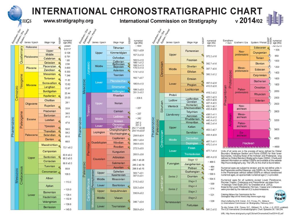
7 A Consistent Temporal Framework Lots of google help out there albeit dated Some useful reference to geologic age classifications But This reference is the 2004 standard. Standards are almost continually being modified
 Geologic Time changes through time International Commission on Stratigraphy")
8 Geologic Ages are a Moving Target Geologic Stage to MYBP age refinement ( ) Databases frequently lock in the age schemas at the time when they were captured. In many cases other classifications are also included: Litho-stratigraphy Type sections or locales Local formation names Ages having no formal definition (e.g. Middle Cretaceous or Middle Oligocene) Geologic Time changes through time International Commission on Stratigraphy
9


10 Translation Table of International Standard Geologic Ages Table shown below is based on GTS 2014 Classification Scheme Coarser time intervals provided for flexibility Can be joined to your data (once conditioned) to standardize it to the International Commission on Stratigraphy GTS2014* GTS2014 Stage Table ArcGIS format

11 How do we get these databases under control and deal with all the legacy data chaos?
")


12 Extract a unique age list from your Data Process your data (Origin Data) using the frequency tool to produce a unique list of age names in a results table more commonly called a Frequency Table Build this using the highest resolution age intervals that are in the data table Frequency Table Origin Data


13 Examples of issues in Database Tables Multiple spellings / Litho-stratigraphy Litho-stratigraphy Older or alternate age classification Inconsistent spelling / multiple entries for same interval Litho-stratigraphy / type section Biostratigraphy Litho-stratigraphy Litho-stratigraphy Inconsistent spelling / multiple entries for same interval Multiple spellings / Litho-stratigraphy Inconsistent spelling / multiple entries for same interval Trailing space

14 Add a column in your Frequency Table to contain correct ages that are standardized: The resultant table is called a Translation Table Note: This remapping step is the most important step to get right and will require geoscience experience Add a column in your Origin Table to receive the remapped attributes


15 Join the Translation Table to the Origin Table To make permanent export the feature data set with the join in place

16 Interactive graphs based on statistics from reclassified age attributes Age intervals summarized in: Total Organic Carbon Hydrogen Index Vitrinite Reflectance

17 Recommendations Use the frequency tool in ArcGIS to thoroughly look through your existing data Commit to a chronostratigrapic standard (and age resolution) everyone wants to work in and carefully reconcile your data to it Build and maintain the translation tables For your local data For vendor data For the age model standard Initial processing and standardization will take a little addition time but there are big benefits: 1. Future raw data sets will have a process in place to deal with them more efficiently 2. All your age specific analysis will become much less daunting to do: o Hydrocarbon discovered volumes by age o Geologic parameter by age o Play assessments 3. Data cleanup product is data that is vetted and able to be loaded into more formal databases (e.g. Oracle)
 Mt Teide at")
18 The requisite sunset picture denoting THE END View from Tenerife (Canary Islands) Mt Teide at sunset

19 Resources Current International Commission on Stratigraphy: Time Stratigraphic Chart Current International Commission on Stratigraphy: Time Stratigraphic Chart
GIS TECHNICIAN I GIS TECHNICIAN II
 GIS TECHNICIAN I GIS TECHNICIAN II CITY OF ROSEVILLE DEFINITION To perform a variety of technical office and field work duties related to the creation and maintenance of maps, tables, graphs and other
The Next Generation GIS/LIS A Surveys Information System Integrated within a GIS
 The Next Generation GIS/LIS A Surveys Information System Integrated within a GIS Michael F. WEIR, USA Key words: Linking, Snapping, GIS, Measurements, Measurement Data, GIS Features, Spatial Quality. SUMMARY
 Tutors: Huw Williams & Paul Davies (Reservoir Geology Consultants Limited) Duration: A six day field and classroom-based reservoir geology and modelling course in Grand Junction, Colorado and Green River,
Lab 2 Geological Time and Fossil Samples
 Geol G308 Paleontology and Geology of Indiana Name: Lab 2 Geological Time and Fossil Samples This lab has two components: understanding geological time scales and choosing fossil samples from the IU Paleontology
Integrating Geomechanics and Reservoir Characterization Examples from Canadian Shale Plays
 Integrating Geomechanics and Reservoir Characterization Examples from Canadian Shale Plays AAPG Geosciences Technology Workshops Geomechanics and Reservoir Characterization of Shale and Carbonates July
G002 An Integrated Regional Framework for Seismic Depth Imaging in the Deepwater Gulf of Mexico
 G002 An Integrated Regional Framework for Seismic Depth Imaging in the Deepwater Gulf of Mexico M. Davidson (Fugro Multi Client Services), M. Leander (Fugro Multi Client Services), K. Mohn (Fugro Multi
Teaching GIS for Land Surveying
 Teaching GIS for Land Surveying Zhanjing (John) Yu Evergreen Valley College, San Jose, California James Crossfield California State University at Fresno, Fresno California 7/13/2006 1 Outline of the Presentation
Geofacets EDUCATION & RESEARCH
 EDUCATION & RESEARCH Geofacets In academic institutions, geoscience departments are tasked with producing high-quality research, instilling best practice research principles in students, and preparing
Geofacets Seminar & Interactive Workshop
 Geofacets Seminar & Workshop University of Bergen Geofacets Seminar & Interactive Workshop UNIVERSITY OF BERGEN Sandra Merten Geofacets Product Manager University of Bergen, 22 March 2017 Geofacets Seminar
Licensed Science Officer Benchmark
 POSITION EVALUATION RATIONALE POSITION TITLE Senior Project Geologist MINISTRY AND DIVISION Energy, Mines and Petroleum Resources: Geological Division BRANCH AND SECTION Mineral Resources UNIT OR PROGRAM
The unique Novaya Zemlya collection at NHM
 The unique Novaya Zemlya collection at NHM (update, photography and initial analysis) Hans Arne Nakrem (Natural History Museum, University of Oslo) 26 January 2007 Holtedahl s 1921 route with the vessel
Geofacets. Do more with less OIL & GAS
 OIL & GAS Geofacets Do more with less Oil and gas companies face major challenges from the dramatic decline in oil prices to the need to drastically cut costs and mitigate risk. They must find ways to
Earth Sciences at the University of Windsor.
 Earth Sciences at the University of Windsor http://www.uwindsor.ca/earth Earth Sciences is:! Geology! Physical Geography! The Environment Our Degree Programs! B.Sc. Geology*! B.Sc. Environmental Geoscience*!
FUNDAMENTALS OF SEISMIC EXPLORATION FOR HYDROCARBON
 FUNDAMENTALS OF SEISMIC EXPLORATION FOR HYDROCARBON Instructor : Kumar Ramachandran 10 14 July 2017 Jakarta The course is aimed at teaching the physical concepts involved in the application of seismic
Landmark LRM. MM and RefPts can be same or different
 1 2 This project began in the fall of 2005. At the time CDOT had three different business units maintaining different LRS s. That is, the beginning and ending reference points and the measured length of
THE USE OF GIS IN GEOTHERMAL RESOURCE MANAGEMENT: A CASE STUDY OF OLKARIA GEOTHERMAL PROJECT
 Presented at SDG Short Course II on Exploration and Development of Geothermal Resources, organized by UNU-GTP, GDC and KenGen, at Lake Bogoria and Lake Naivasha, Kenya, Nov. 9-29, 2017. Kenya Electricity
TECHNICAL STUDIES. rpsgroup.com/energy
 TECHNICAL STUDIES RPS Energy - a global energy consultancy RPS Energy is part of the RPS Group plc, a FTSE 250 company with an annual turnover of $700m and over 4700 employees. As one of the world s leading
GEOGRAPHIC INFORMATION SYSTEM ANALYST I GEOGRAPHIC INFORMATION SYSTEM ANALYST II
 CITY OF ROSEVILLE GEOGRAPHIC INFORMATION SYSTEM ANALYST I GEOGRAPHIC INFORMATION SYSTEM ANALYST II DEFINITION To perform professional level work in Geographic Information Systems (GIS) management and analysis;
GIS Institute Center for Geographic Analysis
 GIS Institute Center for Geographic Analysis Welcome Intensive training in the application of GIS to research Collection, management, analysis, and communication of spatial data Topics include: data collection,
GY 112 Lecture Notes Significance of Fossils: Paleoenvironmental Interpretations
 GY 112 Lecture Notes D. Haywick (2006) 1 GY 112 Lecture Notes Significance of Fossils: Paleoenvironmental Interpretations Lecture Goals: A) The oceans today B) Estimating water depths C) Adaptations to
PETROLEUM GEOSCIENCES
 PETROLEUM GEOSCIENCES Want to work in natural resources? Our Petroleum Geosciences program offers cutting-edge training, based on field trips and tackling case studies proposed by companies within the
So How Does Professional Licensure in Geoscience Impact Me?
 So How Does Professional Licensure in Geoscience Impact Me? Christopher C. Mathewson, PhD, PE, PG Regents Professor, Emeritus, TAMU Department of Geology & Geophysics Subject Matter Expert, Council of
You are Building Your Organization s Geographic Knowledge
 You are Building Your Organization s Geographic Knowledge And Increasingly Making it Available Sharing Data Publishing Maps and Geo-Apps Developing Collaborative Approaches Citizens Knowledge Workers Analysts
EMEKA M. ILOGHALU, NNAMDI AZIKIWE UNIVERSITY, AWKA, NIGERIA.
 Automatic classification of lithofacies and interpretation of depositional environment using Neural Networks Technique - A Novel Computer-Based methodology for 3-D reservoir geological modelling and exploration
Digital Tax Maps Westport Island Project Summary
 Digital Tax Maps Westport Island Project Summary Presented to the: Mid-Coast Regional Planning Commission Creating GIS-Based Digital Tax Maps And Linked Assessment Records For Small Towns on a Budget Dennis
Steve Whittaker, Petroleum Technology Research Centre Stephen Bend, University of Regina Ben Rostron, University of Alberta Gavin Jensen, Ministry of
 Steve Whittaker, Petroleum Technology Research Centre Stephen Bend, University of Regina Ben Rostron, University of Alberta Gavin Jensen, Ministry of Energy & Resources Williston Basin Petroleum Conference
SCHOOL OF ENGINEERING AND TECHNOLOGY COMPUTER LAB
 PHASE 1_6 TH SESSION ARCGIS TRAINING AT KU GIS LABS: INTRODUCTION TO GIS: EXPLORING ARCCATALOG AND ARCGIS TOOLS 6 TH SESSION REPORT: 3 RD -5 TH SEPTEMBER 2014 SCHOOL OF ENGINEERING AND TECHNOLOGY COMPUTER
Oakland County Parks and Recreation GIS Implementation Plan
 Oakland County Parks and Recreation GIS Implementation Plan TABLE OF CONTENTS 1.0 Introduction... 3 1.1 What is GIS? 1.2 Purpose 1.3 Background 2.0 Software... 4 2.1 ArcGIS Desktop 2.2 ArcGIS Explorer
Week 8 Cookbook: Review and Reflection
 : Review and Reflection Week 8 Overview 8.1) Review and Reflection 8.2) Making Intelligent Maps: The map sheet as a blank canvas 8.3) Making Intelligent Maps: Base layers and analysis layers 8.4) ArcGIS
3-D Geological Modelling at the OGS Products and Applications. I made a model!!! Now what?
 3-D Geological ling at the OGS Products and Applications or. I made a model!!! Now what? Abigail Burt Andy Bajc Riley Mulligan Desmond Rainsford John Dodge Meet the team Abigail Burt Andy Bajc Riley Mulligan
Lesson 16: Technology Trends and Research
 http://www.esri.com/library/whitepapers/pdfs/integrated-geoenabled-soa.pdf GEOG DL582 : GIS Data Management Lesson 16: Technology Trends and Research Overview Learning Objective Questions: 1. Why is integration
Distinguishing between analytical precision and assessment accuracy in relation to materials characterisation
 Distinguishing between analytical precision and assessment accuracy in relation to materials characterisation Steven Pearce Principal environmental scientist Perth Presentation overview Heterogeneity,
Managing and Modeling Time-series Geoscience Data in GIS
 Managing and Modeling Time-series Geoscience Data in GIS LARRY ZHANG emap Division, Saudi Aramco West Park 1, Dhahran 31311, Saudi Arabia Email: zhang.huaisu@aramco.com Abstract Many oil and mining companies
STUDYING THE EFFECT OF DISTORTION IN BASIC MAP ELEMENTS FOR THE DEGREE OF SPATIAL ACCURACY OF GAZA STRIP MAPS
 STUDYING THE EFFECT OF DISTORTION IN BASIC MAP ELEMENTS FOR THE DEGREE OF SPATIAL ACCURACY OF GAZA STRIP MAPS Maher A. El-Hallaq Assistant professor, Civil Engineering Department, IUG,, mhallaq@iugaza.edu.ps
JMRS11 Jan Mayen Ridge Sampling Survey 2011
 JMRS11 Jan Mayen Ridge Sampling Survey 2011 JMRS11 Report Presentation VBPR/TGS, February 2012 Confidentiality Screen dumps and the underlying data in this document are confidential and proprietary to
Innovation in Geology and Earth Sciences with ArcGIS. Presented by: Mike Price Entrada/San Juan, Inc. Blaine, WA
 Innovation in Geology and Earth Sciences with ArcGIS Presented by: Mike Price Entrada/San Juan, Inc. Blaine, WA Organization Overview Entrada/San Juan is a GIS consultancy based in Blaine, WA Industries
PETROLEUM GEOSCIENCES GEOLOGY OR GEOPHYSICS MAJOR
 PETROLEUM GEOSCIENCES GEOLOGY OR GEOPHYSICS MAJOR APPLIED GRADUATE STUDIES Geology Geophysics GEO1 Introduction to the petroleum geosciences GEO2 Seismic methods GEO3 Multi-scale geological analysis GEO4
Structure contours on Bone Spring Formation (Lower Permian), Delaware Basin
, Delaware Basin") Structure contours on Bone Spring Formation (Lower Permian), Delaware Basin By Ronald F. Broadhead and Lewis Gillard New Mexico Bureau of Geology and Mineral Resources, a division of New Mexico Tech, Socorro
Structure contours on Bone Spring Formation (Lower Permian), Delaware Basin By Ronald F. Broadhead and Lewis Gillard New Mexico Bureau of Geology and Mineral Resources, a division of New Mexico Tech, Socorro
Short Course. Petroleum Geochemistry & Basin Evaluation. Available to EGI Corporate Associate Members. Overview. Objectives.
 Short Course Instructor: David Thul, M.Sc. Manager of Petroleum Geochemistry Petroleum Geochemistry & Basin Evaluation Available to EGI Corporate Associate Members Course Structure Lectures, presentation
CHAPTER 22 GEOGRAPHIC INFORMATION SYSTEMS
 CHAPTER 22 GEOGRAPHIC INFORMATION SYSTEMS PURPOSE: This chapter establishes the administration and use of to improve the quality and accessibility of Department s spatial information and support graphical
Mapping Historical Information Using GIS
 Mapping Historical Information Using GIS David Yun, GISP Troy Lawson ABSTRACT The City of San Luis Obispo, California, is rich with history. It is one of California s oldest communities that began with
Conference panel Session 98, Defining Data Professionals A Geospatial Industry Perspective on Becoming a Data Professional
 Conference panel Session 98, Defining Data Professionals A Geospatial Industry Perspective on Becoming a Data Professional Dawn J. Wright, Environmental Systems Research Institute (aka Esri), Redlands,
Bridging Subsurface Geologic Databases with Cross-Sections in GIS
 Bridging Subsurface Geologic Databases with Cross-Sections in GIS Eva E. von Thury ESRI International User Conference Padre Associates, Inc. Project Geologist / GIS Analyst June 29, 2016 Outline Introduction
USING EXISTING, PUBLICLY-AVAILABLE DATA TO GENERATE NEW EXPLORATION PROJECTS
 USING EXISTING, PUBLICLY-AVAILABLE DATA TO GENERATE NEW EXPLORATION PROJECTS Philip M. Baker 1, Paul A. Agnew 2 and M. Hooper 1 1 Rio Tinto Exploration, 37 Belmont Ave, Belmont WA 6104. Australia 2 Rio
Efficient Chrono-Stratigraphic Database Structure in GIS
 Efficient Chrono-Stratigraphic Database Structure in GIS Carlos Gabriel Asato, Servicio Geológico Minero Argentino Buenos Aires, Argentina. E-mail gasat@secind.mecon.gov.ar Abstract In recent years the
Techniques for Science Teachers: Using GIS in Science Classrooms.
 Techniques for Science Teachers: Using GIS in Science Classrooms. After ESRI, 2008 GIS A Geographic Information System A collection of computer hardware, software, and geographic data used together for
Log Ties Seismic to Ground Truth
 26 GEOPHYSICALCORNER Log Ties Seismic to Ground Truth The Geophysical Corner is a regular column in the EXPLORER, edited by R. Randy Ray. This month s column is the first of a two-part series titled Seismic
AAPG European Region Annual Conference Paris-Malmaison, France November RESOURCES PERSPECTIVES of the SOUTHERN PERMIAN BASIN AREA
 AAPG European Region Annual Conference Paris-Malmaison, France 23-24 November 2009 RESOURCES PERSPECTIVES of the SOUTHERN PERMIAN BASIN AREA J.C. DOORNENBAL, TNO Built, Environment and Geosciences, Geological
What s new in TS-Creator version 5.4 Released 1 June 2012
 1 What s new in TS-Creator version 5.4 Released 1 June 2012 Version 5.4 has the following major enhancements, which are explained in detail in this document or in the composite Manual. Nearly all were
Here is another list and some practice aimed at translating word problems into mathematical equations.
 DISTANCE = RATE TIMES TIME One of the most daunting tasks in mathematics is to translate a word problem into a mathematical equation. Honestly, there is no one way that works for everyone. Teachers, students,
S/He reports to the Programme Effectiveness Manager. Lead, review and process the development of NO GIS framework and tools.
 GIS Coordinator Location: [Africa] [Ghana] Town/City: Accra Category: Knowledge Management GIS Coordinator To provide leadership and management to cluster staff (of 2 to 3 Area Programs) by ensuring that
OILFIELDS STARTING OPERATION. Offshore & Downhole Technology The Woodlands, Texas Hughes Landing Blvd. #400
 OILFIELDS STARTING OPERATION MAIN ACTIVITIES Geosciences (Design & Execution) Repairing Deposits Evaluation Location Generation Biostratigraphy Production (Design & Planning) Increasing (Artificial Lifting,
The Danish enterprise approach to create and publish nautical products.covering the waters along the west coast of Greenland
 The Danish enterprise approach to create and publish nautical products.covering the waters along the west coast of Greenland Charlotte Bjerregaard Overview of data, charts and tasks Old production/new
DP Project Development Pvt. Ltd.
 Dear Sir/Madam, Greetings!!! Thanks for contacting DP Project Development for your training requirement. DP Project Development is leading professional training provider in GIS technologies and GIS application
Geoscience 001 Fall Rock Identification and Contextual Interpretation
 Geoscience 00 Fall 2005 Rock Identification and Contextual Interpretation The purpose of this week s lab is to gain some more experience and practice in identifying rocks and then interpreting the geologic
Facies Classification Based on Seismic waveform -A case study from Mumbai High North
 5th Conference & Exposition on Petroleum Geophysics, Hyderabad-2004, India PP 456-462 Facies Classification Based on Seismic waveform -A case study from Mumbai High North V. B. Singh, D. Subrahmanyam,
Tools for building and delivering 3D models Perspectives by the BGS
 Tools for building and delivering 3D models Perspectives by the BGS Holger Kessler (on behalf of the 3D community of BGS) Kingsley Dunham Centre Keyworth Nottingham NG12 5GG Tel 0115 936 3100 www.bgs.ac.uk/3dg
Project Participants
 Final Report: 0728050 Final Report for Period: 09/2009-08/2010 Submitted on: 11/01/2010 Principal Investigator: Perdue, E. Michael. Award ID: 0728050 Organization: GA Tech Res Corp - GIT Submitted By:
Petroleum Geology for Non-Geologists
 An Intensive 5 Day Training Course Petroleum Geology for Non-Geologists 16-OCT-17 12-16 Aug 2018, Dubai www.petroknowledge.com Petroleum Geology for Non-Geologists Why Choose this Training Course? The
Chapter 11 (Geologic Time)
") Chapter 11 (Geologic Time) Knowing the chronology of events is crucial for interpreting geologic history. One of the early figures in geology, James Hutton, observed of geologic time that there is "No
Chapter 11 (Geologic Time) Knowing the chronology of events is crucial for interpreting geologic history. One of the early figures in geology, James Hutton, observed of geologic time that there is "No
a system for input, storage, manipulation, and output of geographic information. GIS combines software with hardware,
 Introduction to GIS Dr. Pranjit Kr. Sarma Assistant Professor Department of Geography Mangaldi College Mobile: +91 94357 04398 What is a GIS a system for input, storage, manipulation, and output of geographic
MEEM Design of Experiments Final Take-home Exam
 MEEM 5990 - Design of Experiments Final Take-home Exam Assigned: April 19, 2005 Due: April 29, 2005 Problem #1 The results of a replicated 2 4 factorial experiment are shown in the table below: Test X
A spatial view on the culture heritage domain
 A spatial view on the culture heritage domain Jacob Mendt, Saxon State and University Library Dresden (SLUB) https://creativecommons.org/licenses/by/4.0/ $ whoami Jacob Mendt Background: Geography / Geoinformatics
DATA SOURCES AND INPUT IN GIS. By Prof. A. Balasubramanian Centre for Advanced Studies in Earth Science, University of Mysore, Mysore
 DATA SOURCES AND INPUT IN GIS By Prof. A. Balasubramanian Centre for Advanced Studies in Earth Science, University of Mysore, Mysore 1 1. GIS stands for 'Geographic Information System'. It is a computer-based
Multiattributes and Seismic Interpretation of Offshore Exploratory Block in Bahrain A Case Study
 Multiattributes and Seismic Interpretation of Offshore Exploratory Block in Bahrain A Case Study Suresh Thampi, Aqeel Ahmed, Yahya Al-Ansari, Ali Shehab, Ahmed Fateh, Anindya Ghosh, Ghada Almoulani. The
How to Increase the Significance of your GIS
 How to Increase the Significance of your GIS Wade Kloos, GIS Director, Utah Department of Natural Resources wkloos@utah.gov 2014 Esri International User Conference July 17 How to Increase the Significance
Block 43B - Onshore Oman
 Block 43B - Onshore Oman SUMMARY Block 43B is an 11,967 km 2 area located along the coastal area of Oman north of the Hajar Mountains. This is an unexplored region, both geographically and stratigraphically.
The World Bank and the Open Geospatial Web. Chris Holmes
 The World Bank and the Open Geospatial Web Chris Holmes Geospatial is Everywhere QuickTime and a TIFF (Uncompressed) decompressor are needed to see this picture. Spatial Data Infrastructure (SDI) the sources,
Geosciences Career Pathways (Including Alternative Energy)
") Geosciences Career Pathways (Including Alternative Energy) Shale Carbonates Clastics Unconventionals Geology Characterization and Production Properties of Gas Shales Geomechanics in International Shale
Geosciences Career Pathways (Including Alternative Energy) Shale Carbonates Clastics Unconventionals Geology Characterization and Production Properties of Gas Shales Geomechanics in International Shale
DENR s Oil and Gas Initiative. Legislative briefing March 7, 2011 by DENR s Geological Survey Program
 DENR s Oil and Gas Initiative Legislative briefing March 7, 2011 by DENR s Geological Survey Program South Dakota DOES have exploration for and production of oil and gas Taken from http://denr.sd.gov/des/og/producti.aspx
GIS For The Petroleum Industry. Ken Hood Ulf Becker November 15, 2017
 GIS For The Petroleum Industry Ken Hood Ulf Becker November 15, 2017 Ulf Becker BS, Geology, University of Kansas, 1993 MS, Geology, Northern Arizona University, 1996 Kansas Geological Survey, 1996-97
Applying Mathematical Processes. Symmetry. Resources. The Clothworkers Foundation
 Symmetry Applying Mathematical Processes In this investigation pupils make different symmetrical shapes, using one or m ore of three given shapes. Suitability Pupils working in pairs or small groups Time
Geologic Time: Concepts and Principles
 Geologic Time: Concepts and Principles Introduction - An appreciation for the immensity of geologic time is essential for understanding the history of our planet - Geologists use two references for time
Tom Sneddon 1. Search and Discovery Article # (2015)** Posted September 7, Abstract
** Posted September 7, Abstract") AV Geoscience and Professionalism* Tom Sneddon 1 Search and Discovery Article #110222 (2015)** Posted September 7, 2015 *Adapted from presentation at the AAPG DPA Playmaker, Calgary, Alberta, March 31,
AV Geoscience and Professionalism* Tom Sneddon 1 Search and Discovery Article #110222 (2015)** Posted September 7, 2015 *Adapted from presentation at the AAPG DPA Playmaker, Calgary, Alberta, March 31,
CHALLENGES WITH FOREIGN DATA FORMATS & GEOLOGICAL CONFIDENCE
 CHALLENGES WITH FOREIGN DATA FORMATS & GEOLOGICAL CONFIDENCE Some Case Study Examples from Russia and Central Asia Grant van Heerden, Pr.Sci.Nat. Nick Ryan, CP(Geo) PRESENTATION OVERVIEW The Concept of
Life After College. How should I select my major? What should I select as my major? Will there be a job for me?
 Life After College How should I select my major? What should I select as my major? Will there be a job for me? It s not the degree.... It isn t the piece of paper that matters. There are easy routes to
An Analytic Approach to Sweetspot Mapping in the Eagle Ford Unconventional Play
 An Analytic Approach to Sweetspot Mapping in the Eagle Ford Unconventional Play Murray Roth*, Transform Software and Services, Denver, Colorado, Murray@transformsw.com Michael Roth, Transform Software
Use of DionisosFlow for Reservoir Quality Prediction: Application to the Central Scotian Margin SUMMARY REPORT
 Use of DionisosFlow for Reservoir Quality Prediction: Application to the Central Scotian Margin SUMMARY REPORT Submitted to: Offshore Energy Research Association of Nova Scotia (OERA) to fulfill the requirements
Route To A Remote Sensing Geology Career
 INFORMATION SYSTEMS LLC a U.S. company Route To A Remote Sensing Geology Career Today s Agenda: My Route Potential Employers & Skills Trends Going Forward Take-Away Messages GRSG - September 10, 2014 Cynthia
Wisconsin Academic Standards Science Grade: 8 - Adopted: 1998
 Main Criteria: Wisconsin Academic Standards Secondary Criteria: Subjects: Science, Social Studies Grade: 8 Correlation Options: Show Correlated Wisconsin Academic Standards Science Grade: 8 - Adopted:
Data. Notes. are required reading for the week. textbook reading and a few slides on data formats and data cleaning
 CS 725/825 Information Visualization Fall 2017 Data Dr. Michele C. Weigle http://www.cs.odu.edu/~mweigle/cs725-f17/ Notes } We will not cover these slides in class, but they are required reading for the
Making PPDM a Part of Spatial Data Management Strategies. Volker Hirsinger and Rob Bruinsma, Petrosys
 Making a Part of Spatial Data Management Strategies Volker Hirsinger and Rob Bruinsma, Petrosys Overview Components of spatial applications architectures Diversity in user views and prioritisation of spatial
GIS AS A TOOL FOR MINERAL EXPLORATION
 GIS AS A TOOL FOR MINERAL EXPLORATION By Njagi Dennis Muriithi I13/3169/2008 SGL 413: PROJECT IN GEOLOGY Course coordinators: Dr. C. M. Gichaba Dr. E. Dindi Supervisor: Dr. C. M. Gichaba OUTLINE Introduction
PHASE 1_7 TH SESSION ARCGIS TRAINING AT KU GIS LABS: INTRODUCTION TO GIS: EXPLORING ARCCATALOG AND ARCGIS TOOLS
 PHASE 1_7 TH SESSION ARCGIS TRAINING AT KU GIS LABS: INTRODUCTION TO GIS: EXPLORING ARCCATALOG AND ARCGIS TOOLS 7 TH SESSION REPORT: 10 TH - 12 TH SEPTEMBER 2014 SCHOOL OF ENGINEERING AND TECHNOLOGY COMPUTER
Free Ebooks Laboratory Manual In Physical Geology
 Free Ebooks Laboratory Manual In Physical Geology  ALERT: Before you purchase, check with your instructor or review your course syllabus to ensure that youâ select the correct ISBN. Several versions
Application and Challenges of Artificial Intelligence in Exploration
 Application and Challenges of Artificial Intelligence in Exploration XPLOR 2017 John McGaughey 2017 Mira Geoscience Ltd. Artificial Intelligence Artificial Intelligence is colossally hyped these days,
II. Knowing and Understanding the Six Principles of Stratigraphy:
 Student Name(s): Physical Geology 101 Laboratory Relative Dating of Rocks Using Stratigraphic Principles Grade: I. Introduction & Purpose: The purpose of this lab is to learn and apply the concepts of
Subsurface Geology and Resource Exploration
 LAB 11. Subsurface Geology and Resource Exploration Locating earth resources such as aluminum, copper, gold and gemstones has been an important job for geologists for a long time. This lab deals with the
ARCGIS TRAINING AT KU GIS LABS: INTRODUCTION TO GIS: EXPLORING ARCCATALOG AND ARCGIS TOOLS
 PHASE 1_4 th SESSION ARCGIS TRAINING AT KU GIS LABS: INTRODUCTION TO GIS: EXPLORING ARCCATALOG AND ARCGIS TOOLS 4 th SESSION REPORT: 30 TH JUNE - 2 ND JULY SCHOOL OF ENVIRONMENTAL STUDIES COMPUTER LAB
OTC OTC PP. Abstract
 OTC OTC-19977-PP Using Modern Geophysical Technology to Explore for Bypassed Opportunities in the Gulf of Mexico R.A. Young/eSeis; W.G. Holt, G. Klefstad/ Fairways Offshore Exploration Copyright 2009,
Observing with Modern Observatories
 Observing with Modern Observatories Martino Romaniello European Southern Observatory NEON Archive Observing School 2006 What is modern? (Merriam-Webster dictionary) Main Entry: 1 modern Pronunciation:
Quantitative Seismic Interpretation An Earth Modeling Perspective
 Quantitative Seismic Interpretation An Earth Modeling Perspective Damien Thenin*, RPS, Calgary, AB, Canada TheninD@rpsgroup.com Ron Larson, RPS, Calgary, AB, Canada LarsonR@rpsgroup.com Summary Earth models
Learning Outcomes 2. Key Concepts 2. Misconceptions and Teaching Challenges 3. Vocabulary 4. Lesson and Content Overview 5
 UNIT 1 GUIDE Table of Contents Learning Outcomes 2 Key Concepts 2 Misconceptions and Teaching Challenges 3 Vocabulary 4 Lesson and Content Overview 5 BIG HISTORY PROJECT / UNIT 1 GUIDE 1 Unit 1 What Is
An Algorithms-based Intro to Machine Learning
 CMU 15451 lecture 12/08/11 An Algorithmsbased Intro to Machine Learning Plan for today Machine Learning intro: models and basic issues An interesting algorithm for combining expert advice Avrim Blum [Based
Structure contours on Abo Formation (Lower Permian) Northwest Shelf of Permian Basin
 Northwest Shelf of Permian Basin") Structure contours on Abo Formation (Lower Permian) Northwest Shelf of Permian Basin By Ronald F. Broadhead 1, Lewis Gillard 1, and Nilay Engin 2 1 New Mexico Bureau of Geology and Mineral Resources, a
Structure contours on Abo Formation (Lower Permian) Northwest Shelf of Permian Basin By Ronald F. Broadhead 1, Lewis Gillard 1, and Nilay Engin 2 1 New Mexico Bureau of Geology and Mineral Resources, a
Bentley Geospatial update
 Bentley Geospatial update Tallinna, 01.11.2007 Timo Tuukkanen, Bentley Systems Issues today Bentley Map available now detailed introduction to Bentley Map Bentley Geo Web Publisher Bentley Web GIS update,
BERG-HUGHES CENTER FOR PETROLEUM AND SEDIMENTARY SYSTEMS. Department of Geology and Geophysics College of Geosciences
 BERG-HUGHES CENTER FOR PETROLEUM AND SEDIMENTARY SYSTEMS Department of Geology and Geophysics College of Geosciences MISSION Integrate geoscience, engineering and other disciplines to collaborate with
Clues to Earth s Past
 chapter 3 3 Clues to Earth s Past section 3 Absolute Ages of Rocks What You ll Learn how absolute age differs from relative age how the half-lives of isotopes are used to tell a rock s age Before You Read
Harvey Thorleifson, Director, Minnesota Geological Survey. Status of geological mapping needed for groundwater protection in Minnesota
 Harvey Thorleifson, Director, Minnesota Geological Survey Status of geological mapping needed for groundwater protection in Minnesota Minnesota is located between the Dakotas and Wisconsin, north of Iowa,
1. Omit Human and Physical Geography electives (6 credits) 2. Add GEOG 677:Internet GIS (3 credits) 3. Add 3 credits to GEOG 797: Final Project
 2. Add GEOG 677:Internet GIS (3 credits) 3. Add 3 credits to GEOG 797: Final Project") The Department of Geography and the Office of Professional Studies propose to modify the Master of Professional Studies in Geospatial Information Sciences (GIS) as follows: 1. Omit Human and Physical Geography
The Department of Geography and the Office of Professional Studies propose to modify the Master of Professional Studies in Geospatial Information Sciences (GIS) as follows: 1. Omit Human and Physical Geography