Hydrogeology in clay till. Timo KESSLER, Knud Erik KLINT, Bertel NILSSON and Poul L. BJERG
|
|
|
- Suzan Ramsey
- 6 years ago
- Views:
Transcription
1 Hydrogeology in clay till Timo KESSLER, Knud Erik KLINT, Bertel NILSSON and Poul L. BJERG


2 motivation Risk assessment of contaminated sites How do contaminants spread in the subsurface? Is geological heterogeneity important? Where are contaminants stored? Where do reactions occur?
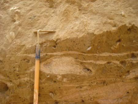
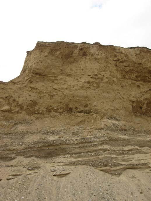
3 sand lenses in clay till Clay till has extremely low hydraulic conductivity Diffusion in the matrix Fractures facilitate vertical transport Sand lenses?? How do sand lenses look in glacial tills? Which types of lenses are important for transport? How can we include sand lenses in hydrogeological models? What kind of data is required? What if no data available? Which role do sand lenses play for (reactive) transport?

4 analog site


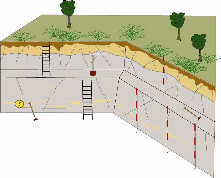

5 analog site


6 characterization Description of single lenses Measure geometry and structures Classification Characterization of sand lenses Mapping of spatial distribution Analysis of variability Stochastic simulation
7 parameters 1. Length 2. Thickness 3. Orientation 4. Fold axis 5. Structures 6. Vertical frequency
8 Table 1: Classification of sand deposits in a typical basal till geometry


9 Table 1: Classification of sand deposits in a typical basal till shapes
10 classification Category Length l h [m] Thickness l v [m] Anisotropy l h /l v [-] Deformation Vertical spacing [m] Genetic interpretation Sample picture sand layers moderate >5.0 proglacial glacio-fluvial sedimentation sand sheets > 50 very strong glaciolacustrine sands, subglacially sheared sand bodies weak supraglacial debris flow or subglacial glacioflucial sands sand pockets strong dislocated pockets originating from larger lenses and stringers < 10 very strong strongly strained and deformed pockets
11 conclusions I How do sand lenses look in glacial tills? oval shaped and elongated lenses with horizontal tailing; strongly anisotropic and very thin due to shear deformation Which types of lenses are important to look at? thick layers are most important, but smaller lenses may create a complex channel network if they are connected

12 mapping sand lenses Define a cross-section Map the lenses Categorize the facies clay till sand lenses
13 analysis z x mean lengths - in x-direction ~80 cm; in z-direction ~7 cm proportion - in clay till typically between sand facie anisotropy - strong vertical anisotropy at ration of instationarity - certain areas within sections have higher numbers of sand lenses than others

14 stochastic simulation Transition probability (TPROGS) based on transition probabilities can deal with irregular data sets geological logs can be used model needs to be conditioned
")

15 stochastic simulation Multiple-point statistics (MPS) uses training images outcrops/conceptualizations are required can simulate 3D realizations
16 hydrogeological model conceptual model of the Vadsby site
17 conclusions II How can we include sand lenses in hydrogeological models? Based on mapping data sand lense distribution can be simulated and included in hydraulic models --!! Spatial resolution!! What kind of data is required? What if no data available? Data on geometry and spatial variability of sand lenses Sand lenses can be conceptualized; borehole logs can be used to condition simulations
18 importance

19 importance sand layer sand body single bodies can alter the flowpaths important reaction compartments kan be observed on logs may be treated as separate units sand sheet sand pocket sand stringer important reaction zones hydraulically only significant if connected can be accounted with stochastic model are difficult to identify on logs
 typical values for clay till are 1*10-5 -5*10-8 Clay till matrix K-values in the order of")
20 K-values Which are the correct hydraulic conductivities? Geological layers slug tests og pumping tests (bulk K) typical values for clay till are 1* *10-8 Clay till matrix K-values in the order of 1* *10-10 Sand lenses true values are difficult to find K-values must be estimated
21 conclusions III Which role do sand lenses play for (reactive) transport? sandy layers and sand bodies can change the hydraulic regime significantly Small sand lenses may impact transport if connected network exists -- 50% of permeable facies needed; anisotropy may lower this ratio All sand lenses are important for reactive processes in the subsurface
22 end
Inverting hydraulic heads in an alluvial aquifer constrained with ERT data through MPS and PPM: a case study
 Inverting hydraulic heads in an alluvial aquifer constrained with ERT data through MPS and PPM: a case study Hermans T. 1, Scheidt C. 2, Caers J. 2, Nguyen F. 1 1 University of Liege, Applied Geophysics
11/22/2010. Groundwater in Unconsolidated Deposits. Alluvial (fluvial) deposits. - consist of gravel, sand, silt and clay
 deposits. - consist of gravel, sand, silt and clay") Groundwater in Unconsolidated Deposits Alluvial (fluvial) deposits - consist of gravel, sand, silt and clay - laid down by physical processes in rivers and flood plains - major sources for water supplies
Groundwater in Unconsolidated Deposits Alluvial (fluvial) deposits - consist of gravel, sand, silt and clay - laid down by physical processes in rivers and flood plains - major sources for water supplies
Application of multiple-point geostatistics on modelling groundwater flow and transport in the Brussels Sands
 Application of multiple-point geostatistics on modelling groundwater flow and transport in the Brussels Sands Marijke Huysmans (1) and Alain Dassargues (1,2) (1) Earth and Environmental Sciences, K.U.Leuven,
3D Modelling of the Uppsala Esker
 3D Modelling of the Uppsala Esker Eva Jirner (SGU) Duncan McConnachie (WSP Sweden) 2017-05-31 ISO/TC211 Geographic Information/Geomatics A collabrative effort Orientation 3 Background Uppsala municiaplity
GEOTECHNICAL ENGINEERING INVESTIGATION HANDBOOK Second Edition
 GEOTECHNICAL ENGINEERING INVESTIGATION HANDBOOK Second Edition Roy E. Hunt Taylor & Francis Taylor & Francis Croup Boca Raton London New York Singapore A CRC title, part of the Taylor & Francis imprint,
Soils, Hydrogeology, and Aquifer Properties. Philip B. Bedient 2006 Rice University
 Soils, Hydrogeology, and Aquifer Properties Philip B. Bedient 2006 Rice University Charbeneau, 2000. Basin Hydrologic Cycle Global Water Supply Distribution 3% of earth s water is fresh - 97% oceans 1%
QUANTIFYING CORRELATION IN THREE-DIMENSIONAL GEOLOGIC MAPPING OF GLACIAL DRIFT
 QUANTIFYING CORRELATION IN THREE-DIMENSIONAL GEOLOGIC MAPPING OF GLACIAL DRIFT John J. Quinn 1 and Howard D Moores 2 1 Argonne National Laboratory, Argonne, IL, USA quinnj@anl.gov 2 Department of Geosciences,
Reservoir characterization
 1/15 Reservoir characterization This paper gives an overview of the activities in geostatistics for the Petroleum industry in the domain of reservoir characterization. This description has been simplified
Aquitard Characterization The Legend of Indiana s Magic Clay Layer. Juliet Port, LPG #2214 July 2014
 Aquitard Characterization The Legend of Indiana s Magic Clay Layer Juliet Port, LPG #2214 July 2014 Topics What is an Aquitard? Why do we care? Review of Indiana glacial geology Conceptual Framework Investigation
Geology and New England Landscapes
 Geology and New England Landscapes Jim Turenne, CPSS USDA-NRCS Warwick, RI. http://nesoil.com Why Geology? Provides the big picture of site conditions. Major part of soil formation (parent material and
Connecticut's Aquifers
 Page 1 of 5 DEP Search: Connecticut's Aquifers The technical definition of the word "aquifer" is: any geologic formation capable of yielding significant quantities of water to wells. By that definition,
David de Courcy-Bower and Samuel Mohr
 Applicability and Limitations of LNAPL Transmissivity as a Metric within Bedrock Formations Insert then choose Picture select your picture. Right click your picture and Send to back. David de Courcy-Bower
Application of Transition Probability Geostatistics in a Detailed Stratigraphic Framework. Gary Weissmann University of New Mexico
 Application of Transition Probability Geostatistics in a Detailed Stratigraphic Framework Gary Weissmann University of New Mexico ACKNOWLEDGEMENTS National Science Foundation American Chemical Society
(Refer Slide Time: 02:10)
") Soil Mechanics Prof. B.V.S. Viswanathan Department of Civil Engineering Indian Institute of Technology, Bombay Lecture 24 Flow of water through soils-v Welcome to lecture five of flow of water through
Soil Mechanics Prof. B.V.S. Viswanathan Department of Civil Engineering Indian Institute of Technology, Bombay Lecture 24 Flow of water through soils-v Welcome to lecture five of flow of water through
LONG ISLAND CLAST ORIENTATIONS
 LONG ISLAND CLAST ORIENTATIONS AND WHAT THEY TILL US Elliot Klein and Dan Davis Department of Geosciences, State University of New York at Stony Brook, 11794 Long Island glacigenic surface deposits, where
Enabling Technologies
 Enabling Technologies Mechanical Modelling 1 Key Parameter Mineral System Exploration is reflected in scale-dependent translation A. Gradient in hydraulic potential B. Permeability C. Solubility sensitivity
Challenges in conditioning a stochastic geological model of a heterogeneous glacial aquifer to a comprehensive soft data set
 doi:10.5194/hess-18-2907-2014 Author(s) 2014. CC Attribution 3.0 License. Challenges in conditioning a stochastic geological model of a heterogeneous glacial aquifer to a comprehensive soft data set J.
Hydrogeology of Deep Borehole Disposal for High-Level Radioactive Waste
 SAND2014-18615C Hydrogeology of Deep Borehole Disposal for High-Level Radioactive Waste Geological Society of America Annual Meeting October 20, 2014 Bill W. Arnold, W. Payton Gardner, and Patrick V. Brady
Site 4.7. Thornhill Drumlin Jane K. Hart
 Site 4.7. Thornhill Drumlin Jane K. Hart Introduction The drumlins in the West of Ireland represent some of the best exposured features in the whole of Britain and Ireland, and have been studied by numerous
3.0 GEOLOGY AND HYDROGEOLOGY
 3.0 GEOLOGY AND HYDROGEOLOGY 3.1 Methodology The Geological Survey of Ireland (GSI) publication Geology of South Cork was consulted to establish the nature of the bedrock lithology and Quaternary sediments.
The syllabus was approved by Study programmes board, Faculty of Science on to be valid from , autumn semester 2016.
 Faculty of Science GEON05, Quaternary Geology: Glacial Sedimentology - Processes, Sediments and Landform Systems, 15 credits Kvartärgeologi: Glacial sedimentologi - processer, sediment och landformssystem,
Appendix D. Sediment Texture and Other Soil Data
 5 6 7 8 Appendix D. Sediment Texture and Other Soil Data This appendix describes the sediment texture of the aquifer system in the Restoration Area. The contents of this appendix describe the: Importance
SASKATCHEWAN STRATIGRAPHY GLACIAL EXAMPLE BOULDERS IN GLACIAL DEPOSITS
 SASKATCHEWAN STRATIGRAPHY GLACIAL EXAMPLE BOULDERS IN GLACIAL DEPOSITS 51 SASKATCHEWAN STRATIGRAPHY GLACIAL SURFICIAL STRATIFIED DEPOSITS 52 SASKATCHEWAN STRATIGRAPHY GLACIAL EXAMPLE OF SEDIMENT DEPOSITION
1.72, Groundwater Hydrology Prof. Charles Harvey Lecture Packet #5: Groundwater Flow Patterns. Local Flow System. Intermediate Flow System
 1.72, Groundwater Hydrology Prof. Charles Harvey Lecture Packet #5: Groundwater Flow Patterns c Local Flow System 10,000 feet Intermediate Flow System Regional Flow System 20,000 feet Hydrologic section
Reservoir Geomechanics and Faults
 Reservoir Geomechanics and Faults Dr David McNamara National University of Ireland, Galway david.d.mcnamara@nuigalway.ie @mcnamadd What is a Geological Structure? Geological structures include fractures
Groundwater Sequence Stratigraphy:
 Groundwater Sequence Stratigraphy: A Geology-based Approach for Developing Accurate and Representative Hydrogeologic Conceptual Models for Successful Groundwater Sustainability Plans Rick Cramer, Burns
Tu P8 08 Modified Anisotropic Walton Model for Consolidated Siliciclastic Rocks: Case Study of Velocity Anisotropy Modelling in a Barents Sea Well
 Tu P8 08 Modified Anisotropic Walton Model for Consolidated Siliciclastic Rocks: Case Study of Velocity Anisotropy Modelling in a Barents Sea Well Y. Zhou (Rock Solid Images), F. Ruiz (Repsol), M. Ellis*
Finding Large Capacity Groundwater Supplies for Irrigation
 Finding Large Capacity Groundwater Supplies for Irrigation December 14, 2012 Presented by: Michael L. Chapman, Jr., PG Irrigation Well Site Evaluation Background Investigation Identify Hydrogeologic Conditions
SD-100 SD-200 SITE AND EXPLORATION PLAN SODO SEGMENT. FIG. 3 Sheet 4 of 9. Seattle Monorail Project Seattle, Washington Scale in Feet
 Central Parking Lot potential downhole arrary location (site visit //) PREFERRED New Parking Area File: I: \Drafting \\- \plans \-- Plans.dwg Date: -- Author: LR Current downhole array location LEGEND
2. REGIS II: PARAMETERIZATION OF A LAYER-BASED HYDROGEOLOGICAL MODEL
 HYDRAULIC PARAMETERIZATION OF 3D SUBSURFACE MODELS: FROM MEASUREMENT-SCALE TO MODEL-SCALE Jan L. Gunnink, Jan Stafleu, Denise Maljers and Jan Hummelman TNO Geological Survey of the Netherlands, P.O. Box
Characterisation of Quaternary deposits in West Cumbria using the concept of domains: A case study
 Characterisation of Quaternary deposits in West using the concept of domains: a case study Characterisation of Quaternary deposits in West using the concept of domains: A case study Jon Merritt Quaternary
The Concept of Block-Effective Macrodispersion for Numerical Modeling of Contaminant Transport. Yoram Rubin
 The Concept of Block-Effective Macrodispersion for Numerical Modeling of Contaminant Transport Yoram Rubin University of California at Berkeley Thanks to Alberto Bellin and Alison Lawrence Background Upscaling
Geophysical Surveys for Groundwater Modelling of Coastal Golf Courses
 1 Geophysical Surveys for Groundwater Modelling of Coastal Golf Courses C. RICHARD BATES and RUTH ROBINSON Sedimentary Systems Research Group, University of St. Andrews, St. Andrews, Scotland Abstract
HYDROGEOLOGICAL PROPERTIES OF THE UG2 PYROXENITE AQUIFERS OF THE BUSHVELD COMPLEX
 R. Gebrekristos, P.Cheshire HYDROGEOLOGICAL PROPERTIES OF THE UG2 PYROXENITE AQUIFERS OF THE BUSHVELD COMPLEX R. Gebrekristos Digby Wells Environmental P. Cheshire Groundwater Monitoring Services Abstract
We 21 C15 Geophysical Investigation for an Assessment of Sinkhole Risk in Schleswig-Holstein/Northern Germany
 We 21 C15 Geophysical Investigation for an Assessment of Sinkhole Risk in Schleswig-Holstein/Northern Germany R. Kirsch* (LLUR-SH), H. Wiederhold (LIAG), W. Rabbel (CAU), E. Erkul (CAU), C. Thomsen (LLUR-SH),
Lower Mainland Surficial Geology From Wisconsin Ice Age to Protocol 21
 Lower Mainland Surficial Geology From Wisconsin Ice Age to Protocol 21 BCEIA BEST Conference 2018 Whistler, BC Kalina Malowany and Virginie Brunetaud Presentation Outline 1. Surficial Geology it s more
Maggie Payne Jim Turenne
 Maggie Payne Jim Turenne USDA-NRCS 60 Quaker Lane, Suite 46 Warwick, RI. 02886 401-822-8832 maggie.payne@ri.usda.gov U.S. Department of Agriculture 1935: Soil Conservation Service (SCS) Natural Resources
AN APPROACH TO THE CLASSIFICATION OF SLOPE MOVEMENTS
 Training/workshop on Earthquake Vulnerability and Multi-Hazard Risk Assessment: Geospatial Tools for Rehabilitation and Reconstruction Effort 13 31 March 2006, Islamabad, Pakistan AN APPROACH TO THE CLASSIFICATION
Groundwater in Bayfield County
 Groundwater in Bayfield County Presented to Bayfield County Large Scale Livestoc Study Committee April 23, 2015 Madeline Gotowitz Hydrogeologist Groundwater in Bayfield County Groundwater basics Hydrogeology
RATE OF FLUID FLOW THROUGH POROUS MEDIA
 RATE OF FLUID FLOW THROUGH POROUS MEDIA Submitted by Xu Ming Xin Kiong Min Yi Kimberly Yip Juen Chen Nicole A project presented to the Singapore Mathematical Society Essay Competition 2013 1 Abstract Fluid
Procedure for Determining Near-Surface Pollution Sensitivity
 Procedure for Determining Near-Surface Pollution Sensitivity Minnesota Department of Natural Resources Division of Ecological and Water Resources County Geologic Atlas Program March 2014 Version 2.1 I.
Site Characterization & Hydrogeophysics
 Site Characterization & Hydrogeophysics (Source: Matthew Becker, California State University) Site Characterization Definition: quantitative description of the hydraulic, geologic, and chemical properties
Somenath Kar*, Krishnendu Ghosh*, Arnab Ghosh*, Koushik Sikdar*, Udit Kumar Guru*, Priyanka Bhattacharya*, K.M Sundaram**, G M Chavan**
 P-419 Summary Characterizing the Clay Particle distribution in Deepwater Channel Levee Complex using Borehole Micro Image and Multi Triaxial Induction Measurement: A Case Studies from Eastern Offshore
Geochemistry of Landscapes Covered by Glacially Crushed Debris. William W. Shilts
 Geochemistry of Landscapes Covered by Glacially Crushed Debris William W. Shilts Comminution (crushing) processes dominate glacial sediment production and deposition, trumping chemical weathering, hydrology,
Chapter 12 Subsurface Exploration
 Page 12 1 Chapter 12 Subsurface Exploration 1. The process of identifying the layers of deposits that underlie a proposed structure and their physical characteristics is generally referred to as (a) subsurface
PRINCIPAUX ENJEUX LIÉS AUX AQUIFÈRES DE SOCLE
 PRINCIPAUX ENJEUX LIÉS AUX AQUIFÈRES DE SOCLE John M. Sharp, Jr. Department of Geological Sciences Jackson School of Geosciences The University of Texas Austin, Texas, USA Uwe Troeger* Lehrstuhl fuer Hydrogeologie
From 2D Seismic to Hydrodynamic Modelling
 From 2D Seismic to Hydrodynamic Modelling A Complex Study of Turbidites in a Petroleum-Bearing Basin Marcell Lux, HC Exploration Geologist Ahmed Amran, HC Exploration Advisor Marianna Vincze, Geomodel
patersongroup Consulting Engineers April 20, 2010 File: PG1887-LET.01R Novatech Engineering Consultants Suite 200, 240 Michael Cowpland Drive
 patersongroup April 20, 2010 File: PG1887-LET.01R Novatech Engineering Consultants Suite 200, 240 Michael Cowpland Drive Ottawa, Ontario K2M 1P6 Attention: Mr. Adam Thompson Consulting Engineers 28 Concourse
An Investigation on the Effects of Different Stress Regimes on the Magnitude Distribution of Induced Seismic Events
 An Investigation on the Effects of Different Stress Regimes on the Magnitude Distribution of Induced Seismic Events Afshin Amini, Erik Eberhardt Geological Engineering, University of British Columbia,
Exploration Significance of Unconformity Structure on Subtle Pools. 1 Vertical structure characteristics of unconformity
 Exploration Significance of Unconformity Structure on Subtle Pools Wu Kongyou (China University of Petroleum,College of Geo-Resources and Information,Shandong Qingdao 266555) Abstract: Vertical structure
GLG 471; MICHIGAN STATE UNIVERSITY INSTRUCTOR R.L. VAN DAM PROJECT: ELECTRICAL RESISTIVITY
 GLG 471; MICHIGAN STATE UNIVERSITY INSTRUCTOR R.L. VAN DAM PROJECT: ELECTRICAL RESISTIVITY General information: This is a group (2-3 students) project requiring lab-, computer-, and fieldwork. Work will
Hydro One (Sept 2014) Hydro One (Sept 2014) Hydro One (Sept 2014)
 Hydro One (Sept 2014) Hydro One (Sept 2014)") TABLE 1 WELL CONSTRUCTION DETAILS MOE WWR No Well ID Location Installation Date Status Easting Coordinates Northing Source Elevation Screened Interval Screened Material Borehole Well Stick-up Ground Top
TABLE 1 WELL CONSTRUCTION DETAILS MOE WWR No Well ID Location Installation Date Status Easting Coordinates Northing Source Elevation Screened Interval Screened Material Borehole Well Stick-up Ground Top
b Blackwell Science Environmental Geology PRINCIPLES AND PRACTICE
 Environmental Geology PRINCIPLES AND PRACTICE Fred G. Bell Department of Geology and Applied Geology University of Natal, Durban, South Africa b Blackwell Science Preface, ix 1 Introduction, 1 1.1 Planning
Training Venue and Dates Ref # Reservoir Geophysics October, 2019 $ 6,500 London
 Training Title RESERVOIR GEOPHYSICS Training Duration 5 days Training Venue and Dates Ref # Reservoir Geophysics DE035 5 07 11 October, 2019 $ 6,500 London In any of the 5 star hotels. The exact venue
Buried-valley Aquifers: Delineation and Characterization from Reflection Seismic and Core Data at Caledon East, Ontario
 Buried-valley Aquifers: Delineation and Characterization from Reflection Seismic and Core Data at Caledon East, Ontario Russell, H.A.J. 1, S.E. Pullan 1, J.A. Hunter 1, D.R. Sharpe 1, and S. Holysh 2 1
Basin Analysis Applied to Modelling Buried Valleys in the Great Lakes Basin
 EARTH SCIENCES SECTOR GENERAL INFORMATION PRODUCT 35 Basin Analysis Applied to Modelling Buried Valleys in the Great Lakes Basin Sharpe, D R; Russell, H A J 2004 Originally released as: Basin Analysis
Summary. Introduction. Observations and Interpretations
 Lower McMurray Formation sinkholes and their fill fabrics: effects of salt dissolution collapse-subsidence across the northern Athabasca oil sands deposit Paul L. Broughton, Chevron Canada Resources, Calgary,
Revitalizing Mature Fields
 JOURNAL OF PETROLEUM TECHNOLOGY www.jptonline.org OCTOBER 2012 O C TO B E R 2 0 1 2 VO LU M E 6 4, N U M B E R 1 0 Revitalizing Mature Fields Field Development Projects Tight Reservoirs Knowledge Management
Applications of Borehole Imaging to Hydrocarbon Exploration and Production
 Applications of Borehole Imaging to Hydrocarbon Exploration and Production Instructor: Philippe MONTAGGION / NExT, Schlumberger Title: Petroleum Geology Consultant Specialty: Borehole Imaging, Petroleum
Pressure Grouting of Fractured Bedrock to Control Acid Mine Drainage
 WATER RESOURCES AT RISK May 14-18, 1995 Denver American Institute of Hydrology Pressure Grouting of Fractured Bedrock to Control Acid Mine Drainage S. A. Effner, G. D. Vandersluis, and V. Straskraba Hydro-Geo
APPLICATION OF 1D HYDROMECHANICAL COUPLING IN TOUGH2 TO A DEEP GEOLOGICAL REPOSITORY GLACIATION SCENARIO
 PROCEEDINGS, TOUGH Symposium 2015 Lawrence Berkeley National Laboratory, Berkeley, California, September 28-30, 2015 APPLICATION OF 1D HYDROMECHANICAL COUPLING IN TOUGH2 TO A DEEP GEOLOGICAL REPOSITORY
Azimuthal Resistivity to Characterize Fractures in a Glacial Till. Mark Boris, University of Saskatchewan Jim Merriam, University of Saskatchewan
 Azimuthal Resistivity to Characterize Fractures in a Glacial Till Mark Boris, University of Saskatchewan Jim Merriam, University of Saskatchewan Abstract Azimuthal resistivity was used to characterize
FEMA. GEOL 440 Sedimentology and stratigraphy: processes, environments and deposits
 Lecture 11: Alluvial Fan Facies FEMA GEOL 440 Sedimentology and stratigraphy: processes, environments and deposits Debris-flow and flooding hazards associated with the December 1999 storm in coastal Venezuela
ENVIRONMENTAL GEOSCIENCE UNIFORM SYLLABUS
 ENVIRONMENTAL GEOSCIENCE UNIFORM SYLLABUS The Association of Professional Engineers and Geoscientists of the Province of British Columbia Note: 1. This Syllabus May Be Subject To Change 2. These Courses
Understanding Subsurface Fate & Transport
 Back-to-Basics Part 1: Developing the CSM & Site Characterization Understanding Subsurface Fate & Transport Understanding Subsurface Fate & Transport Purpose: To provide an introduction to the basics of
Holocene Sediments of the Rhine-Meuse-Scheldt Estuaries as Aids to Interpret Tidal and Fluvial-Tidal Deposits in Outcrop and Core*
 Holocene Sediments of the Rhine-Meuse-Scheldt Estuaries as Aids to Interpret Tidal and Fluvial-Tidal Deposits in Outcrop and Core* Allard W. Martinius 1 and J.H. (Janrik) van den Berg 2 Search and Discovery
Groundwater Hydrology
 EXERCISE 12 Groundwater Hydrology INTRODUCTION Groundwater is an important component of the hydrologic cycle. It feeds lakes, rivers, wetlands, and reservoirs; it supplies water for domestic, municipal,
Reliability of Seismic Data for Hydrocarbon Reservoir Characterization
 Reliability of Seismic Data for Hydrocarbon Reservoir Characterization Geetartha Dutta (gdutta@stanford.edu) December 10, 2015 Abstract Seismic data helps in better characterization of hydrocarbon reservoirs.
Case Study: University of Connecticut (UConn) Landfill
 Landfill") Case Study: University of Connecticut (UConn) Landfill Problem Statement:» Locate disposal trenches» Identify geologic features and distinguish them from leachate and locate preferential pathways in fractured
Case Study: University of Connecticut (UConn) Landfill Problem Statement:» Locate disposal trenches» Identify geologic features and distinguish them from leachate and locate preferential pathways in fractured
Subsurface Geology of the Kennebec River
 Maine Geologic Facts and Localities July, 1998 Subsurface Geology of the Kennebec River 43 54 40.75 N, 69 48 29.01 W Text by Daniel B. Locke, Department of Agriculture, Conservation & Forestry 1 Map by
PART 2:! FLUVIAL HYDRAULICS" HYDROEUROPE
 PART 2:! FLUVIAL HYDRAULICS" HYDROEUROPE 2009 1 HYDROEUROPE 2009 2 About shear stress!! Extremely complex concept, can not be measured directly!! Computation is based on very primitive hypotheses that
Geological Mapping using Geophysics
 Geological Mapping using Geophysics Pugin, A.J.M. and T.H. Larson Illinois State Geological Survey, 615 E Peabody Dr., Champaign, IL 61820; E-mail: A.J.M. Pugin at pugin@isgs.uiuc.edu Mapping Techniques.
A Risk-based Groundwater Modelling Study for Predicting Thermal Plume Migration from SAGD Well-pads
 A Risk-based Groundwater Modelling Study for Predicting Thermal Plume Migration from SAGD Well-pads Rudy Maji, Ph.D., Golder Associates Solaleh Khezri, M.Sc., AB Scientific Intern (Golder Associates) Don
Geologic Considerations of Shallow SAGD Caprock; Seal Capacity, Seal Geometry and Seal Integrity, Athabasca Oilsands, Alberta Canada
 Geologic Considerations of Shallow SAGD Caprock; Seal Capacity, Seal Geometry and Seal Integrity, Athabasca Oilsands, Alberta Canada Gordon T. Stabb, Michael Webb Durando Resources Corp, Suncor Energy
Horizontal Directional Drilling: An Approach to Design and Construction. Presenter: John Briand, PE Co-Author: Danielle Neamtu, PE
 Horizontal Directional Drilling: An Approach to Design and Construction Presenter: John Briand, PE Co-Author: Danielle Neamtu, PE Presentation Outline General HDD overview Conceptual-level evaluation Detailed
- Cased-hole geophysical well logs - Airborne geophysics - Seismic data - LiDAR. GeoConvention 2015: New Horizons 1
 Thermal Effects and Quaternary Hydrogeology: Making Good Decisions in a Complex Geologic Setting Timothy Johnsen, Phd, Quaternary Specialist (tjohnsen@matrix-solutions.com) Alex Haluszka, MSc, P.Geol.,
AWRA PMAS Engineers Club of Philadelphia. A Geologic Perspective on Stormwater
 AWRA PMAS Engineers Club of Philadelphia A Geologic Perspective on Stormwater Toby J. Kessler, P.G. Hydrogeologist Trevor G. Woodward, P.G. Engineering Geologist September 10, 2014 Gilmore & Associates,
Hierarchical Geostatistical Analysis of an Experimental Stratigraphy
 DOI 10.1007/s11004-008-9180-6 Hierarchical Geostatistical Analysis of an Experimental Stratigraphy Ye Zhang Received: 31 August 2006 / Accepted: 28 January 2008 International Association for Mathematical
The Palmer Hill Glacial-Marine Delta, Whitefield, Maine
 Maine Geologic Facts and Localities December, 2010, Maine 44 o 10 12.16 N, 69 o 37 18.93 W Text by Woodrow Thompson, Department of Agriculture, Conservation & Forestry 1 Introduction The most recent continental
NEW PRODUCTS AND ADVANCEMENTS IN 3-D MODELLING PROTOCOLS BASED ON STUDIES IN THICK DRIFT AREAS IN ONTARIO, CANADA
 NEW PRODUCTS AND ADVANCEMENTS IN 3-D MODELLING PROTOCOLS BASED ON STUDIES IN THICK DRIFT AREAS IN ONTARIO, CANADA Abigail K. Burt and Andrew F. Bajc Ontario Geological Survey, 933 Ramsey Lake Road, Sudbury,
Sequence Stratigraphy as a tool for water resources management in alluvial coastal aquifers: application to the Llobregat delta (Barcelona, Spain)
") Sequence Stratigraphy as a tool for water resources management in alluvial coastal aquifers: application to the Llobregat delta (Barcelona, Spain) Desiré Gàmez Torrent December 2007 CHAPTER 1: Introduction
Sequence Stratigraphy as a tool for water resources management in alluvial coastal aquifers: application to the Llobregat delta (Barcelona, Spain) Desiré Gàmez Torrent December 2007 CHAPTER 1: Introduction
Critical Borehole Orientations Rock Mechanics Aspects
 Critical Borehole Orientations Rock Mechanics Aspects By R. BRAUN* Abstract This article discusses rock mechanics aspects of the relationship between borehole stability and borehole orientation. Two kinds
Production-induced stress change in and above a reservoir pierced by two salt domes: A geomechanical model and its applications
 Production-induced stress change in and above a reservoir pierced by two salt domes: A geomechanical model and its applications Peter Schutjens, Jeroen Snippe, Hassan Mahani, Jane Turner, Joel Ita and
Parameters for groundwater modelling
 Parameters for groundwater modelling, Arto Pullinen and Antti Pasanen Seminar on management of water balance in mining areas, 28.8.2015, SYKE 28.08.2015 1 Introduction WaterSmart Project GTK s main task
Geophysical Exploration in Water Resources Assessment. John Mundell, P.E., L.P.G., P.G. Ryan Brumbaugh, L.P.G. Mundell & Associates, Inc.
 Geophysical Exploration in Water Resources Assessment John Mundell, P.E., L.P.G., P.G. Ryan Brumbaugh, L.P.G. Mundell & Associates, Inc. Presentation Objective Introduce the use of geophysical survey methods
Chapter 5. Heterogeneous Simulations 5.1 Introduction
 Chapter 5. Heterogeneous Simulations 5.1 Introduction In order for a numerical model to accurately predict subsurface transport and biodegradation, it must account for the physical variations within soils
Final Report on Development of Deep Aquifer Database and Preliminary Deep Aquifer Map
 4 CHAPTER Final Report on Development of Deep Aquifer Database and Preliminary Deep Aquifer Map 31 Chronostragraphic Mapping 4.1 Introduction The analysis of geological logs was conducted during the project
STABLE ISOTOPES AS RECORD OF CLIMATIC CHANGES OF DANIGLACIAL IN LITHUANIA
 GEOCHRONOMETRIA Vol. 20, pp 81-86, 2001 Journal on Methods and Applications of Absolute Chronology STABLE ISOTOPES AS RECORD OF CLIMATIC CHANGES OF DANIGLACIAL IN LITHUANIA ALGIRDAS GAIGALAS 1, ANNA PAZDUR
Table of Contents Chapter 1 Introduction to Geotechnical Engineering 1.1 Geotechnical Engineering 1.2 The Unique Nature of Soil and Rock Materials
 Table of Contents Chapter 1 Introduction to Geotechnical Engineering 1.1 Geotechnical Engineering 1.2 The Unique Nature of Soil and Rock Materials 1.3 Scope of This Book 1.4 Historical Development of Geotechnical
Non-stationary hydrostratigraphic model of crosscutting
 International Journal of Hydrology Research Article Open Access Non-stationary hydrostratigraphic model of crosscutting alluvial fans Abstract The groundwater system of southern Sacramento County was formed
Multiple-Point Geostatistics: from Theory to Practice Sebastien Strebelle 1
 Multiple-Point Geostatistics: from Theory to Practice Sebastien Strebelle 1 Abstract The limitations of variogram-based simulation programs to model complex, yet fairly common, geological elements, e.g.
The Interaction of Reservoir Engineering and Geomechanics (a story)
") The Interaction of Reservoir Engineering and Geomechanics (a story) Brian G D Smart FREng, FRSE, FIMMM, CEng Petromall Ltd Why is the interaction a good thing? Assertion - Reservoir Geomechanics enables
The Interaction of Reservoir Engineering and Geomechanics (a story) Brian G D Smart FREng, FRSE, FIMMM, CEng Petromall Ltd Why is the interaction a good thing? Assertion - Reservoir Geomechanics enables
The SPE Foundation through member donations and a contribution from Offshore Europe
 Primary funding is provided by The SPE Foundation through member donations and a contribution from Offshore Europe The Society is grateful to those companies that allow their professionals to serve as
PREDICTION OF ACID MINE DRAINAGE POTENTIAL FROM COAL MINES
 PREDICTION OF ACID MINE DRAINAGE POTENTIAL FROM COAL MINES Arthur W. Rose, Professor of Geochemistry Eugene G. Williams, Professor of Geology Richard R. Parizek, Professor of Hydrogeology Acid mine drainage
FORMATION OF GROUNDWATER IN SEDIMENTARY BASINS: TRADITIONAL AND ALTERNATIVE MODELS
 FORMATION OF GROUNDWATER IN SEDIMENTARY BASINS: TRADITIONAL AND ALTERNATIVE MODELS Albertas Bitinas Klaipėda University, Coastal Research and Planning Institute, H. Manto St. 84, Klaipėda, Lithuania, albertas.bitinas@corpi.ku.lt
Integrating 3-D Facies Analysis of Glacial Aquifer Systems with Groundwater Flow Models: Examples from New England and the Great Lakes Region, USA
 Integrating 3-D Facies Analysis of Glacial Aquifer Systems with Groundwater Flow Models: Examples from New England and the Great Lakes Region, USA Stone, B.D., J.R. Stone, J.P. Masterson, and D.W. O'Leary
Variations in the Rus Formation
 Variations in the Rus Formation The Need for Consistent Core Logging Sallie Vest Halcrow / CH2M Hill 7 Nov 2012- TIME Not exposed at ground surface Umm Er- Raduh ma Paleogen e Eocene Damma m Cenozoic Oligoce
DEPARTMENT OF GEOSCIENCES
 DEPARTMENT OF GEOSCIENCES Office in Natural Resources Building, Room 322 (970) 491-7826 warnercnr.colostate.edu/geosciences-home (http:// warnercnr.colostate.edu/geosciences-home) Richard Aster, Department
Glacier Hydrology II: Theory and Modeling
 Glacier Hydrology II: Theory and Modeling McCarthy Summer School 2018 Matt Hoffman Gwenn Flowers, Simon Fraser Operated by Los Alamos National Security, LLC for the U.S. Department of Energy's NNSA Observations
Lower Skinner Valley Fill Sandstones: Attractive Exploration Targets on the Northeast Oklahoma Platform*
 Lower Skinner Valley Fill Sandstones: Attractive Exploration Targets on the Northeast Oklahoma Platform* By Jim Puckette 1 Search and Discovery Article #10050 (2003) *Adapted from presentation to Tulsa