Application of Transition Probability Geostatistics in a Detailed Stratigraphic Framework. Gary Weissmann University of New Mexico
|
|
|
- Charleen Johns
- 5 years ago
- Views:
Transcription
1 Application of Transition Probability Geostatistics in a Detailed Stratigraphic Framework Gary Weissmann University of New Mexico
2 ACKNOWLEDGEMENTS National Science Foundation American Chemical Society Petroleum Research Fund US Department of Agriculture US Geological Survey University of California Water Resources Center Occidental Chemical Company Geological Society of America Graham Fogg Yong Zhang Eric LaBolle Steve Carle Thomas Harter Karen Burow George Bennett Sarah Norris Deitz Warnke Ken Verosub Jeffrey Mount Michael Singer Gordon Huntington
3 Goal: Develop quantified models of heterogeneity that accurately reflect: Geologic variability Multi-scale nature of stratigraphy Honor actual field data (core, well log) Can be used in groundwater models

4
5 Transition Probability Geostatistics (TPROGS) Method of Carle and Fogg, 1996 Indicator geostatistical method; Creates geologically realistic simulations of heterogeneity; Models incorporate soft geological data as well as measured parameters; Realizations honor known data points; Asymmetrical distributions modeled.
6 Advantages of the TPROGS Approach Markov chain models capture: Mean lengths Facies (hydrofacies) proportions Juxtaposition relationships Additionally, during simulation we can incorporate: Stratigraphic dips Stratigraphic orientations (anisotropy)


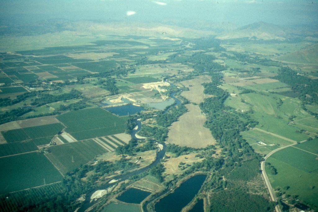
7 Kings River Alluvial Fan Fresno 1980 Landsat MSS false color from USGS NALC program. 20km
8 STEPS FOR MODELING 1. Define and model overall stratigraphy and define units where local stationarity is a reasonable assumption. 2. Measure vertical transition probabilities between facies within each unit and fit 1-D Markov chain model(s) to these measured results. 3. Measure or estimate lateral transition probabilities and estimate lateral Markov chain models for each unit. a. From well data b. From other sources (e.g., soil surveys, geological maps). 4. Simulate each unit separately. a. Conditional Sequential Indicator Simulation. b. Simulated Quenching. 5. Combine simulation results into single realization of system.
9 CYCLES ON FLUVIAL FANS Interglacial Low accumulation space Initial Glacial Outwash Increasing accumulation space Continued Glacial Outwash High accumulation space Transition to Interglacial Decreasing accumulation space Weissmann et al, 2002, JSR


10 From Weissmann et al in press
11 Kings River Alluvial Fan Dip Section Basinward Apex From Weissmann et al 2002

12 From Weissmann et al 2004
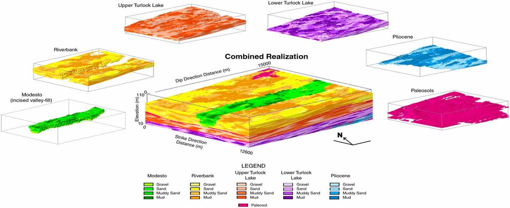
13 Identified Hydrofacies Within Sequences Gravel (channel deposits) Sand (channel deposits) Muddy Sand (coarse floodplain deposits) Mud (fine floodplain deposits) Paleosol (soils due to extended periods of exposure)


14 From Weissmann et al 2004
15 STEPS FOR MODELING 1. Define and model overall stratigraphy and define units where local stationarity is a reasonable assumption. 2. Measure vertical transition probabilities between facies within each unit and fit 1-D Markov chain model(s) to these measured results. 3. Measure or estimate lateral transition probabilities and estimate lateral Markov chain models for each unit. a. From well data b. From other sources (e.g., soil surveys, geological maps). 4. Simulate each unit separately. a. Conditional Sequential Indicator Simulation. b. Simulated Quenching. 5. Combine simulation results into single realization of system.

16 Kings River Alluvial Fan Open Fan Deposits Vertical Transition Probabilities (GAMEAS/GRAFXX)
17 STEPS FOR MODELING 1. Define and model overall stratigraphy and define units where local stationarity is a reasonable assumption. 2. Measure vertical transition probabilities between facies within each unit and fit 1-D Markov chain model(s) to these measured results. 3. Measure or estimate lateral transition probabilities and estimate lateral Markov chain models for each unit. a. From well data b. From other sources (e.g., soil surveys, geological maps). c. Application of Walther s Law 4. Simulate each unit separately. a. Conditional Sequential Indicator Simulation. b. Simulated Quenching. 5. Combine simulation results into single realization of system.

18 75 Miles of GPR data Collected (Bennett 2003)

19 Channel Facies Dimension Estimates Bennett et al submitted
20 STEPS FOR MODELING 1. Define and model overall stratigraphy and define units where local stationarity is a reasonable assumption. 2. Measure vertical transition probabilities between facies within each unit and fit 1-D Markov chain model(s) to these measured results. 3. Measure or estimate lateral transition probabilities and estimate lateral Markov chain models for each unit. a. From well data b. From other sources (e.g., soil surveys, geological maps). c. Application of Walther s Law 4. Simulate each unit separately. a. Conditional Sequential Indicator Simulation. b. Simulated Quenching. 5. Combine simulation results into single realization of system.
21
22 Realizations capture: Contrasting character between different stratigraphic units. Fining-upward successions (gravel up to sand up to muddy sand) Juxtapositional tendencies (fining-outward successions) Radial pattern of fan deposits Dipping beds Reasonable channel sand and floodplain fine distributions. It looks geological. And honor conditioning data points Multiple realizations can be run to assess uncertainty.
23 Our goal: Produce realistic heterogeneity for groundwater flow and contaminant transport modeling.
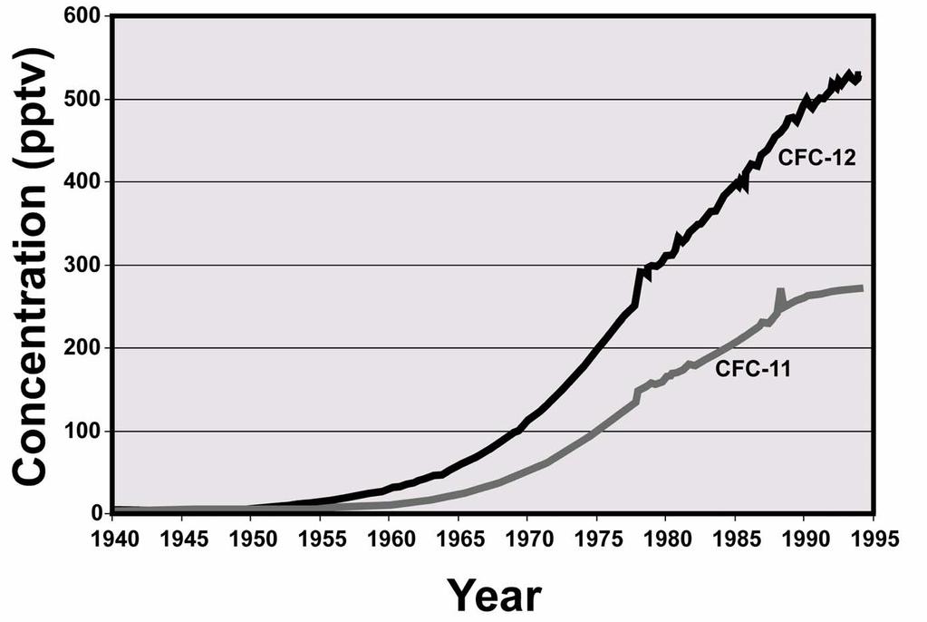
24 Modeling Applications to Date Kings River Alluvial Fan 1. Evaluation of Groundwater Age Date from Chlorofluorocarbons (CFC) - Weissmann et al. 2002, WRR, v Groundwater Flow and Contaminant Transport Around Incised Valley Fill Sediments - Weissmann et al. 2004, SEPM Special Publication 80
25
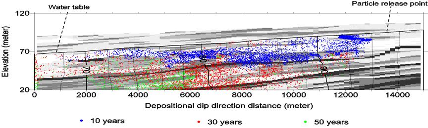
 Age (years) : 10 30 50 70 90 Vertical Exageration:")
26 Release from Well B Elevation (meter) Dip Direction Distance (meter) Age (years) : Vertical Exageration: 50:1
27
28 Measured vs. Simulated CFC Concentrations

29 Particle movement around paleovalley fill years after releasing 10,000 particles years after releasing 10,000 particles Weissmann et al 2004, SEPM Special Publication 80
30 CONCLUSIONS Multi-scale, non-stationary models produced: Large-scale: deterministic modeling Intermediate-scale: stochastic modeling in deterministic stratigraphic framework Small-scale: stochastic modeling or appropriate dispersivities The transition probability geostatistics approach: Produces geologically reasonable realizations of aquifer heterogeneity. Allows for incorporation of geological concepts into model development. Improved groundwater modeling and contaminant transport simulation. Groundwater age date distributions (CFC age dating). Models of stratigraphic influence.
31
Non-stationary hydrostratigraphic model of crosscutting
 International Journal of Hydrology Research Article Open Access Non-stationary hydrostratigraphic model of crosscutting alluvial fans Abstract The groundwater system of southern Sacramento County was formed
Appendix D. Sediment Texture and Other Soil Data
 5 6 7 8 Appendix D. Sediment Texture and Other Soil Data This appendix describes the sediment texture of the aquifer system in the Restoration Area. The contents of this appendix describe the: Importance
Solute transport in a heterogeneous aquifer: a search for nonlinear deterministic dynamics
 Nonlinear Processes in Geophysics (2005) 12: 211 218 SRef-ID: 1607-7946/npg/2005-12-211 European Geosciences Union 2005 Author(s). This work is licensed under a Creative Commons License. Nonlinear Processes
Integrated Stratigraphic and Hydrogeologic Aquifer Analysis: Toward Improved Multi-scale Characterization of Alluvial Aquifer Systems
 Integrated Stratigraphic and Hydrogeologic Aquifer Analysis: Toward Improved Multi-scale Characterization of Alluvial Aquifer Systems PI: Gary Weissmann, University of New Mexico Funded by: NSF CAREER
Transiogram: A spatial relationship measure for categorical data
 International Journal of Geographical Information Science Vol. 20, No. 6, July 2006, 693 699 Technical Note Transiogram: A spatial relationship measure for categorical data WEIDONG LI* Department of Geography,
Challenges in conditioning a stochastic geological model of a heterogeneous glacial aquifer to a comprehensive soft data set
 doi:10.5194/hess-18-2907-2014 Author(s) 2014. CC Attribution 3.0 License. Challenges in conditioning a stochastic geological model of a heterogeneous glacial aquifer to a comprehensive soft data set J.
Quantitative Seismic Interpretation An Earth Modeling Perspective
 Quantitative Seismic Interpretation An Earth Modeling Perspective Damien Thenin*, RPS, Calgary, AB, Canada TheninD@rpsgroup.com Ron Larson, RPS, Calgary, AB, Canada LarsonR@rpsgroup.com Summary Earth models
Review of permeability in buried-valley aquifers: Centimeter to kilometer scales
 Review of permeability in buried-valley aquifers: Centimeter to kilometer scales R. W. RITZI, Z. DAI & D. F. DOMINIC Department of Geological Sciences, Wright State University, Dayton, Ohio 45435, USA
Stochastic Simulation of Inclined Heterolithic Stratification with Streamline-based Stochastic Models
 Stochastic Simulation of Inclined Heterolithic Stratification with Streamline-based Stochastic Models Michael J. Pyrcz and Clayton V. Deutsch Department of Civil and Environmental Engineering, University
QUANTIFYING CORRELATION IN THREE-DIMENSIONAL GEOLOGIC MAPPING OF GLACIAL DRIFT
 QUANTIFYING CORRELATION IN THREE-DIMENSIONAL GEOLOGIC MAPPING OF GLACIAL DRIFT John J. Quinn 1 and Howard D Moores 2 1 Argonne National Laboratory, Argonne, IL, USA quinnj@anl.gov 2 Department of Geosciences,
DATA ANALYSIS AND INTERPRETATION
 III. DATA ANALYSIS AND INTERPRETATION 3.1. Rift Geometry Identification Based on recent analysis of modern and ancient rifts, many previous workers concluded that the basic structural unit of continental
11/22/2010. Groundwater in Unconsolidated Deposits. Alluvial (fluvial) deposits. - consist of gravel, sand, silt and clay
 deposits. - consist of gravel, sand, silt and clay") Groundwater in Unconsolidated Deposits Alluvial (fluvial) deposits - consist of gravel, sand, silt and clay - laid down by physical processes in rivers and flood plains - major sources for water supplies
Groundwater in Unconsolidated Deposits Alluvial (fluvial) deposits - consist of gravel, sand, silt and clay - laid down by physical processes in rivers and flood plains - major sources for water supplies
River-Aquifer Interactions, Geologic Heterogeneity, and Low Flow Management
 ARTICLE IN PRESS, to appear in 2006 River-Aquifer Interactions, Geologic Heterogeneity, and Low Flow Management by Jan H. Fleckenstein 1, Richard. G. Niswonger 2, Graham E. Fogg 3 Abstract Low river flows
HYBRID DETERMINISTIC AND STOCHASTIC HYDROSTRATIGRAPHIC MODELING OF A COMPLEX GLACIAL AQUIFER SYSTEM
 HYBRID DETERMINISTIC AND STOCHASTIC HYDROSTRATIGRAPHIC MODELING OF A COMPLEX GLACIAL AQUIFER SYSTEM Lawrence D. Lemke, Andrew L. Frahm, Lena K. Pappas Department of Geology, Wayne State University, Detroit,
Inverting hydraulic heads in an alluvial aquifer constrained with ERT data through MPS and PPM: a case study
 Inverting hydraulic heads in an alluvial aquifer constrained with ERT data through MPS and PPM: a case study Hermans T. 1, Scheidt C. 2, Caers J. 2, Nguyen F. 1 1 University of Liege, Applied Geophysics
DOWNSTREAM SORTING OF SEDIMENT (additional control on channel width, depth and slope)
") DOWNSTREAM SORTING OF SEDIMENT (additional control on channel width, depth and slope) Image removed due to copyright concerns As the gravel gets finer, it is transported at lower slopes. The result is
DOWNSTREAM SORTING OF SEDIMENT (additional control on channel width, depth and slope) Image removed due to copyright concerns As the gravel gets finer, it is transported at lower slopes. The result is
Buried-valley Aquifers: Delineation and Characterization from Reflection Seismic and Core Data at Caledon East, Ontario
 Buried-valley Aquifers: Delineation and Characterization from Reflection Seismic and Core Data at Caledon East, Ontario Russell, H.A.J. 1, S.E. Pullan 1, J.A. Hunter 1, D.R. Sharpe 1, and S. Holysh 2 1
Groundwater Monitoring & Aggregate Operations in the Villeneuve-Calahoo Area. William Gowdy, BSc. P.Geo
 Groundwater Monitoring & Aggregate Operations in the Villeneuve-Calahoo Area William Gowdy, BSc. P.Geo Format of Talk General Background Sand and Gravel Geology & Formation of Sand and Gravel Deposits
3D Hydrogeological Structure Modeling Based on TPROGS A Case Study from the West Liaohe Plain
 2015 2 nd International Conference on Material Engineering and Application (ICMEA 2015) ISBN: 978-1-60595-323-6 3D Hydrogeological Structure Modeling Based on TPROGS A Case Study from the West Liaohe Plain
Modeling Lateral Accretion in McMurray Formation Fluvial- Estuarine Channel Systems: Grizzly Oil Sands May River SAGD Project, Athabasca
 Modeling Lateral Accretion in McMurray Formation Fluvial- Estuarine Channel Systems: Grizzly Oil Sands May River SAGD Project, Athabasca Duncan Findlay, Thomas Nardin, Alex Wright, Raheleh Salehi Mojarad
Accommodation. Tectonics (local to regional) Subsidence Uplift
 Subsidence Uplift") Accommodation Accommodation varies over time; it is the distance between a reference horizon and the sea surface (i.e. relative sea level). The space to be filled in with sediments or water What are the
Accommodation Accommodation varies over time; it is the distance between a reference horizon and the sea surface (i.e. relative sea level). The space to be filled in with sediments or water What are the
Daniel Koning, Peggy Johnson, and John Hawley. New Mexico Bureau of Geology and Mineral Resources
 Daniel Koning, Peggy Johnson, and John Hawley Daniel Koning 1, Gary Smith 2, and Adam Read 1 1 New Mexico Bureau of Geology and Mineral Resources 2 University of New Mexico Santa Fe Group Definition (Spiegel
Chapter 8: Learning objectives
 Chapter 8: Learning objectives Understand concept of sedimentary facies Signinifance of lateral and vertical facies associations Walther s Law Understand the sedimentary facies of alluvial fans, eolian
NAME: GEL 109 Final Study Guide - Winter 2008 Questions 6-24 WILL be on the final exactly as written here; this is 60% of the test.
 GEL 109 Final Study Guide - Winter 2008 Questions 6-24 WILL be on the final exactly as written here; this is 60% of the test. 1. Sketch a map view of three types of deltas showing the differences in river,
GEL 109 Midterm W05, Page points total (1 point per minute is a good pace, but it is good to have time to recheck your answers!
 GEL 109 Midterm W05, Page 1 50 points total (1 point per minute is a good pace, but it is good to have time to recheck your answers!) 1. Are the following flow types typically laminar or turbulent and
Nathan D. Webb and James L. Best
 Nathan D. Webb and James L. Best Background Pennsylvanian oil production Stratigraphy & geologic setting Study area Methods Using geophysical logs & core Results Comparing three channel deposits Implications
Stratigraphic modelling using CHILD
 5 Stratigraphic modelling using CHILD 5.1 Triangular irregular network Surface process models are widely used in geomorphology and geology, and the developments in the field follow each other rapidly.
Hydrogeology in clay till. Timo KESSLER, Knud Erik KLINT, Bertel NILSSON and Poul L. BJERG
 Hydrogeology in clay till Timo KESSLER, Knud Erik KLINT, Bertel NILSSON and Poul L. BJERG motivation Risk assessment of contaminated sites How do contaminants spread in the subsurface? Is geological heterogeneity
Reservoir characterization
 1/15 Reservoir characterization This paper gives an overview of the activities in geostatistics for the Petroleum industry in the domain of reservoir characterization. This description has been simplified
Subsurface Geology of the Kennebec River
 Maine Geologic Facts and Localities July, 1998 Subsurface Geology of the Kennebec River 43 54 40.75 N, 69 48 29.01 W Text by Daniel B. Locke, Department of Agriculture, Conservation & Forestry 1 Map by
Clyde River Landslide
 Clyde River Landslide Department of Geology, Perkins Hall, University of Vermont, Burlington, VT 05405 Abstract: This paper investigates a landslide on the Clyde River in Newport, Vermont. The landslide
Lower Skinner Valley Fill Sandstones: Attractive Exploration Targets on the Northeast Oklahoma Platform*
 Lower Skinner Valley Fill Sandstones: Attractive Exploration Targets on the Northeast Oklahoma Platform* By Jim Puckette 1 Search and Discovery Article #10050 (2003) *Adapted from presentation to Tulsa
Diagnostic Geomorphic Methods for Understanding Future Behavior of Lake Superior Streams What Have We Learned in Two Decades?
 Diagnostic Geomorphic Methods for Understanding Future Behavior of Lake Superior Streams What Have We Learned in Two Decades? Faith Fitzpatrick USGS WI Water Science Center, Middleton, WI fafitzpa@usgs.gov
A NOVEL APPROACH TO GROUNDWATER MODEL DEVELOPMENT. Thomas D. Krom 1 and Richard Lane 2
 A NOVEL APPROACH TO GROUNDWATER MODEL DEVELOPMENT Thomas D. Krom 1 and Richard Lane 2 1 Touch Water Ltd., P.O. Box 143, Lincoln, Christchurch, New Zealand; email: touchwater@gmail.com 2 Applied Research
Final Exam. Running Water Erosion and Deposition. Willamette Discharge. Running Water
 Final Exam Running Water Erosion and Deposition Earth Science Chapter 5 Pages 120-135 Scheduled for 8 AM, March 21, 2006 Bring A scantron form A calculator Your 3 x 5 paper card of formulas Review questions
Infilled Kettle Hole, Easton, Aroostook County, Maine
 Maine Geologic Facts and Localities June, 1997, Maine 46 41 26.40 N, 67 48 35.74 W Text by Tom Weddle, Department of Agriculture, Conservation & Forestry 1 Introduction As the last continental glacier
FLUVIAL LANDFORMS. Floodplains
 FLUVIAL LANDFORMS Floodplains fairly flat & continuous surface occupying much of a valley bottom normally underlain by unconsolidated sediments subject to periodic flooding (usually once every year or
Annotated Bibliography of River Avulsions Pat Dryer Geography 364 5/14/2007
 Annotated Bibliography of River Avulsions Pat Dryer Geography 364 5/14/2007 1 Table of Contents Introduction 2 Annotations I. River avulsions and their deposits 2 II. Channel avulsion on alluvial fans
NAME: GEL 109 Final Winter 2010
 GEL 109 Final Winter 2010 1. The following stratigraphic sections represents a single event followed by the slow accumulation of background sedimentation of shale. Describe the flows that produced the
SUPPLEMENTAL INFORMATION DELFT 3-D MODELING: MODEL DESIGN, SETUP, AND ANALYSIS
 GSA DATA REPOSITORY 2014069 Hajek and Edmonds SUPPLEMENTAL INFORMATION DELFT 3-D MODELING: MODEL DESIGN, SETUP, AND ANALYSIS Each experiment starts from the initial condition of a straight channel 10 km
Basin Analysis Applied to Modelling Buried Valleys in the Great Lakes Basin
 EARTH SCIENCES SECTOR GENERAL INFORMATION PRODUCT 35 Basin Analysis Applied to Modelling Buried Valleys in the Great Lakes Basin Sharpe, D R; Russell, H A J 2004 Originally released as: Basin Analysis
Bulletin of Earth Sciences of Thailand
 Depositional Environments and Stratigraphic Development of the Grand Taman Sari Circuit Outcrop: an Analogue for Transgressive Mahakam Delta Successions Ridha Santika Riadi Petroleum Geoscience Program,
Sediment and Sedimentary rock
 Sediment and Sedimentary rock Sediment: An accumulation of loose mineral grains, such as boulders, pebbles, sand, silt or mud, which are not cemented together. Mechanical and chemical weathering produces
Enhanced Characterization of the Mississippi River Valley Alluvial Aquifer Using Surface Geophysical Methods
 Photo by Shane Stocks, U.S. Geological Survey Enhanced Characterization of the Mississippi River Valley Alluvial Aquifer Using Surface Geophysical Methods Presented by Ryan F. Adams US Geological Survey
Michigan s Geology and Groundwater
 Michigan s Geology and Groundwater Ralph J. Haefner Deputy Director U.S. Geological Survey Michigan-Ohio Water Science Center Lansing, Michigan Outline About the USGS Geology 101 Michigan s geology Bedrock
GY 402: Sedimentary Petrology
 UNIVERSITY OF SOUTH ALABAMA GY 402: Sedimentary Petrology Lecture 17: Sandy Fluvial Depositional Environments Instructor: Dr. Douglas W. Haywick Last Time Volcaniclastic Sedimentary Rocks 1. Origin of
STUDY GUIDE FOR CONTENT MASTERY. Surface Water Movement
 Surface Water SECTION 9.1 Surface Water Movement In your textbook, read about surface water and the way in which it moves sediment. Complete each statement. 1. An excessive amount of water flowing downslope
Mammoth Cave National Park, Kentucky
 Mammoth Cave National Park, Kentucky Objectives of Today s Lecture Refresher on Sedimentary Depositional Systems and Rock Classifications Transgressive and Regressive Marine Environments Carbonate Depositional
Groundwater Sequence Stratigraphy:
 Groundwater Sequence Stratigraphy: A Geology-based Approach for Developing Accurate and Representative Hydrogeologic Conceptual Models for Successful Groundwater Sustainability Plans Rick Cramer, Burns
Case Study of the Structural and Depositional-Evolution Interpretation from Seismic Data*
 Case Study of the Structural and Depositional-Evolution Interpretation from Seismic Data* Yun Ling 1, Xiangyu Guo 1, Jixiang Lin 1, and Desheng Sun 1 Search and Discovery Article #20143 (2012) Posted April
Environmental Sequence Stratigraphy: A Focus on Geology for Improved Remediation Decision Making
 Environmental Sequence Stratigraphy: A Focus on Geology for Improved Remediation Decision Making Rick Cramer, PG (Burns and McDonnell); Mike Shultz (AECOM); Colin Plank (AECOM); Herb Levine (US EPA, Region
Lecture 19: Fluvial Facies
 GEOL 440 Sedimentology and stratigraphy: processes, environments and deposits Lecture 19: Fluvial Facies Aims Examine controls on alluvial channel pattern List the types of channel pattern Examine meandering
River floodplain regime and stratigraphy. Drs. Nanette C. Kingma.
 River floodplain regime and stratigraphy. Drs. Nanette C. Kingma. Formation of floodplain. Formation of floodplains: lateral channel migration in channel deposition suspended-load fall out during higher
Best Practice Reservoir Characterization for the Alberta Oil Sands
 Best Practice Reservoir Characterization for the Alberta Oil Sands Jason A. McLennan and Clayton V. Deutsch Centre for Computational Geostatistics (CCG) Department of Civil and Environmental Engineering
- Cased-hole geophysical well logs - Airborne geophysics - Seismic data - LiDAR. GeoConvention 2015: New Horizons 1
 Thermal Effects and Quaternary Hydrogeology: Making Good Decisions in a Complex Geologic Setting Timothy Johnsen, Phd, Quaternary Specialist (tjohnsen@matrix-solutions.com) Alex Haluszka, MSc, P.Geol.,
Sediment and sedimentary rocks Sediment
 Sediment and sedimentary rocks Sediment From sediments to sedimentary rocks (transportation, deposition, preservation and lithification) Types of sedimentary rocks (clastic, chemical and organic) Sedimentary
ES 105 Surface Processes I. Hydrologic cycle A. Distribution % in oceans 2. >3% surface water a. +99% surface water in glaciers b.
 ES 105 Surface Processes I. Hydrologic cycle A. Distribution 1. +97% in oceans 2. >3% surface water a. +99% surface water in glaciers b. >1/3% liquid, fresh water in streams and lakes~1/10,000 of water
Summary. Introduction. Observations and Interpretations
 Lower McMurray Formation sinkholes and their fill fabrics: effects of salt dissolution collapse-subsidence across the northern Athabasca oil sands deposit Paul L. Broughton, Chevron Canada Resources, Calgary,
Holocene Lower Mississippi River Avulsions: Autogenic Versus Allogenic Forcing*
 Holocene Lower Mississippi River Avulsions: Autogenic Versus Allogenic Forcing* Eric Prokocki 1,2 Search and Discovery Article #50330 (2010) Posted October 14, 2010 *Adapted from oral presentation at AAPG
Reducing Uncertainty in Modelling Fluvial Reservoirs by using Intelligent Geological Priors
 Reducing Uncertainty in Modelling Fluvial Reservoirs by using Intelligent Geological Priors Temístocles Rojas 1, Vasily Demyanov 2, Mike Christie 3 & Dan Arnold 4 Abstract Automatic history matching reservoir
Sedimentary System Characteristics of Deng-3 Section on Paleo-central. Uplift Belt in Northern Songliao Basin. Siyang Li1,a*
 Sedimentary System Characteristics of Deng-3 Section on Paleo-central Uplift Belt in Northern Songliao Basin Siyang Li1,a* 1 School of Earth Sciences and Resources, China University of Geosciences, Beijing,
FUTURE MEANDER BEND MIGRATION AND FLOODPLAIN DEVELOPMENT PATTERNS NEAR RIVER MILES 241 TO 235, SACRAMENTO RIVER
 FUTURE MEANDER BEND MIGRATION AND FLOODPLAIN DEVELOPMENT PATTERNS NEAR RIVER MILES 241 TO 235, SACRAMENTO RIVER Eric W. Larsen University of California, Davis With the assistance of Evan Girvetz REPORT
Sarah Jane Riordan. Australian School of Petroleum University of Adelaide March 2009
 Managing the Interdisciplinary Requirements of 3D Geological Models Sarah Jane Riordan Australian School of Petroleum University of Adelaide March 2009 Thesis submitted in accordance with the requirements
Delineating well-head protection areas under conditions of hydrogeological uncertainty. A case-study application in northern Greece
 Environ. Process. (2015) 2 (Suppl 1):S113 S122 DOI 10.1007/s40710-015-0087-1 ORIGINAL ARTICLE Delineating well-head protection areas under conditions of hydrogeological uncertainty. A case-study application
Geology and New England Landscapes
 Geology and New England Landscapes Jim Turenne, CPSS USDA-NRCS Warwick, RI. http://nesoil.com Why Geology? Provides the big picture of site conditions. Major part of soil formation (parent material and
27. Running Water I (p ; )
") 27. Running Water I (p. 424-436; 440-444) Hydrosphere How much of the Earth s surface is covered by water? Earth's water is collectively called the and is stored in a number of so-called as follows: 1.
27. Running Water I (p. 424-436; 440-444) Hydrosphere How much of the Earth s surface is covered by water? Earth's water is collectively called the and is stored in a number of so-called as follows: 1.
Moosehead Lake and the Tale of Two Rivers
 Maine Geologic Facts and Localities June, 2005 45 o 53 5.09 N, 69 o 42 14.54 W Text by Kelley, A.R.; Kelley, J.T.; Belknap, D.F.; and Gontz, A.M. Department of Earth Sciences, University of Maine, Orono,
EASTON, CA POLLUTANT PLUMES. By Dr. David Cehrs. April 2012
 EASTON, CA POLLUTANT PLUMES By Dr. David Cehrs April 2012 Sampling for pollutants at Easton, CA occurred in 1995-1997 and again in 2012. At both times nitrates and DBCP were sampled. In 2012 uranium and
GEL 109 Midterm W01, Page points total (1 point per minute is a good pace, but it is good to have time to recheck your answers!
 GEL 109 Midterm W01, Page 1 50 points total (1 point per minute is a good pace, but it is good to have time to recheck your answers!) 1. Where in a water flow is there usually a zone of laminar flow even
Your web browser (Safari 7) is out of date. For more security, comfort and the best experience on this site: Update your browser Ignore
 is out of date. For more security, comfort and the best experience on this site: Update your browser Ignore") Your web browser (Safari 7) is out of date. For more security, comfort and the best experience on this site: Update your browser Ignore ALLU VIAL FAN colluvial fan, debris cone For the complete encyclopedic
Your web browser (Safari 7) is out of date. For more security, comfort and the best experience on this site: Update your browser Ignore ALLU VIAL FAN colluvial fan, debris cone For the complete encyclopedic
EARTH SURFACE PROCESSES AND SEDIMENTATION!
 Sed and Strat EARTH SURFACE PROCESSES AND SEDIMENTATION! 2/27 Lecture 7- Exposure: Weathering and the Sediment Factory 3/04 Lecture 8 - Rivers and Landscapes 3/06 Lecture 9 - Waves (not Tides) 3/11 Lecture
Evolution of the conceptual hydrogeologic and ground-water flow model for Las Vegas Valley, Clark County, Nevada
 Evolution of the conceptual hydrogeologic and ground-water flow model for Las Vegas Valley, Clark County, Nevada Geological Society of America Annual Meeting November 14, 2 David J. Donovan Southern Nevada
ES120 Sedimentology/Stratigraphy
 Midterm Exam 5/05/08 NAME: 1. List or describe 3 physical processes that contribute to the weathering of rocks (3pts). exfoliation frost wedging many others. roots, thermal expansion/contraction also credit
Michael Walsworth, Ryan Sullivan, Simi Odueyungbo, William Budd
 Michael Walsworth, Ryan Sullivan, Simi Odueyungbo, William Budd Estuarine Environment At first (Pritchard, 1967), an estuary was defined by the salinity of the water. Then by Clifton (1982) as an inlet
Facies Modeling in Presence of High Resolution Surface-based Reservoir Models
 Facies Modeling in Presence of High Resolution Surface-based Reservoir Models Kevin Zhang Centre for Computational Geostatistics Department of Civil and Environmental Engineering University of Alberta
Application of multiple-point geostatistics on modelling groundwater flow and transport in the Brussels Sands
 Application of multiple-point geostatistics on modelling groundwater flow and transport in the Brussels Sands Marijke Huysmans (1) and Alain Dassargues (1,2) (1) Earth and Environmental Sciences, K.U.Leuven,
Laboratory Exercise #3 The Hydrologic Cycle and Running Water Processes
 Laboratory Exercise #3 The Hydrologic Cycle and Running Water Processes page - 1 Section A - The Hydrologic Cycle Figure 1 illustrates the hydrologic cycle which quantifies how water is cycled throughout
RIVERS, GROUNDWATER, AND GLACIERS
 RIVERS, GROUNDWATER, AND GLACIERS Delta A fan-shaped deposit that forms when a river flows into a quiet or large body of water, such as a lake, an ocean, or an inland sea. Alluvial Fan A sloping triangle
Hierarchical Geostatistical Analysis of an Experimental Stratigraphy
 DOI 10.1007/s11004-008-9180-6 Hierarchical Geostatistical Analysis of an Experimental Stratigraphy Ye Zhang Received: 31 August 2006 / Accepted: 28 January 2008 International Association for Mathematical
Application of Predictive Modeling to the Lower Cretaceous Sedimentary Sequences of the Central Scotian Basin
 Application of Predictive Modeling to the Lower Cretaceous Sedimentary Sequences of the Central Scotian Basin Christopher R. Sangster 1, Nicolas Hawie 2, Georgia Pe-Piper 1, Francky Saint-Ange 2, David
Modeling Lateral Accretion in McMurray Formation Fluvial-Estuarine Channel Systems: Grizzly Oil Sands May River SAGD Project, Athabasca*
 Modeling Lateral Accretion in McMurray Formation Fluvial-Estuarine Channel Systems: Grizzly Oil Sands May River SAGD Project, Athabasca* Duncan Findlay 1, Thomas Nardin 1, Alex Wright 1, and Raheleh Salehi
RESULTS FROM THE TEXAS COASTAL SEDIMENT SOURCES: A GENERAL EVALUATION STUDY
 RESULTS FROM THE TEXAS COASTAL SEDIMENT SOURCES: A GENERAL EVALUATION STUDY JUAN MOYA KELSEY CALVEZ CRIS WEBER ANTHONY RISKO *KEVIN FRENZEL FREESE AND NICHOLS, INC. COASTAL AND WATERWAYS GROUP OBJECTIVES
16 AUGUST (Monday) Glacial Sediment
 Glacial Sediment") Presented By: U.S. Army Corps of Engineers, Detroit District Great Lakes Hydraulics and Hydrology Office With Support from the Great Lakes Commission 16 AUGUST (Monday) Glacial Sediment 9:00 9:30 Introduction
Presented By: U.S. Army Corps of Engineers, Detroit District Great Lakes Hydraulics and Hydrology Office With Support from the Great Lakes Commission 16 AUGUST (Monday) Glacial Sediment 9:00 9:30 Introduction
PHASE 1 STUDIES UPDATE EROSION WORKING GROUP
 PHASE 1 STUDIES UPDATE EROSION WORKING GROUP Presented By MICHAEL WOLFF, PG Erosion Study Area Manager West Valley Demonstration Project Quarterly Public Meeting February 24, 2016 OUTLINE Study 1 Terrain
Debris flow: categories, characteristics, hazard assessment, mitigation measures. Hariklia D. SKILODIMOU, George D. BATHRELLOS
 Debris flow: categories, characteristics, hazard assessment, mitigation measures Hariklia D. SKILODIMOU, George D. BATHRELLOS Natural hazards: physical phenomena, active in geological time capable of producing
Reservoir Modeling with GSLIB. Overview
 Reservoir Modeling with GSLIB Overview Objectives of the Course What is Geostatistics? Why Geostatistics / 3-D Modeling? Uncertainty Quantification and Decision Making Heterogeneous Reservoir Modeling
Experimental and Theoretical Study of Strata Formation in Sedimentary Basins
 Experimental and Theoretical Study of Strata Formation in Sedimentary Basins Chris Paola St. Anthony Falls Laboratory University of Minnesota Minneapolis MN 55414 phone: (612) 624-8025 fax: (612) 624-4398
August 21, 2015 Project No. EH130228A. Concrete Nor West P.O. Box 280 Mount Vernon, Washington Attention: Mr. Dan Cox
 August 21, 2015 Project No. EH130228A Concrete Nor West P.O. Box 280 Mount Vernon, Washington 98273 Attention: Mr. Dan Cox Subject: Hydrogeologic Site Assessment Concrete Nor West Grip Road Mine Skagit
Running Water Earth - Chapter 16 Stan Hatfield Southwestern Illinois College
 Running Water Earth - Chapter 16 Stan Hatfield Southwestern Illinois College Hydrologic Cycle The hydrologic cycle is a summary of the circulation of Earth s water supply. Processes involved in the hydrologic
Multiple-Point Geostatistics: from Theory to Practice Sebastien Strebelle 1
 Multiple-Point Geostatistics: from Theory to Practice Sebastien Strebelle 1 Abstract The limitations of variogram-based simulation programs to model complex, yet fairly common, geological elements, e.g.
Ensemble Kalman filter assimilation of transient groundwater flow data via stochastic moment equations
 Ensemble Kalman filter assimilation of transient groundwater flow data via stochastic moment equations Alberto Guadagnini (1,), Marco Panzeri (1), Monica Riva (1,), Shlomo P. Neuman () (1) Department of
A Markov Chain Model for Subsurface Characterization: Theory and Applications 1
 Mathematical Geology, Vol. 33, No. 5, 2001 A Markov Chain Model for Subsurface Characterization: Theory and Applications 1 Amro Elfeki 2 and Michel Dekking 3 This paper proposes an extension of a single
What do you need for a Marathon?
 What do you need for a Marathon? Water and a snack? What about just a normal day? 1 flush = 3.5 gallons 1 flush = 3.5 gallons 10 minute shower = 20 gal 1 flush = 3.5 gallons 10 minute shower = 20 gal Jeans
GY 402: Sedimentary Petrology
 UNIVERSITY OF SOUTH ALABAMA GY 402: Sedimentary Petrology Lecture 13: Immature Siliciclastic Sedimentary Environments Alluvial Fans, Braided Streams Instructor: Dr. Douglas W. Haywick Last Time Immature
Aquifer an underground zone or layer of sand, gravel, or porous rock that is saturated with water.
 Aggradation raising of the streambed by deposition that occurs when the energy of the water flowing through a stream reach is insufficient to transport sediment conveyed from upstream. Alluvium a general
Maggie Payne Jim Turenne
 Maggie Payne Jim Turenne USDA-NRCS 60 Quaker Lane, Suite 46 Warwick, RI. 02886 401-822-8832 maggie.payne@ri.usda.gov U.S. Department of Agriculture 1935: Soil Conservation Service (SCS) Natural Resources
GEOL.3250 Geology for Engineers Glacial Geology
 GEOL.3250 Geology for Engineers Glacial Geology NAME Part I: Continental Glaciation Continental glaciers are large ice sheets that cover substantial portions of the land area. In the region of accumulation
Soils, Hydrogeology, and Aquifer Properties. Philip B. Bedient 2006 Rice University
 Soils, Hydrogeology, and Aquifer Properties Philip B. Bedient 2006 Rice University Charbeneau, 2000. Basin Hydrologic Cycle Global Water Supply Distribution 3% of earth s water is fresh - 97% oceans 1%
Integrating 3-D Facies Analysis of Glacial Aquifer Systems with Groundwater Flow Models: Examples from New England and the Great Lakes Region, USA
 Integrating 3-D Facies Analysis of Glacial Aquifer Systems with Groundwater Flow Models: Examples from New England and the Great Lakes Region, USA Stone, B.D., J.R. Stone, J.P. Masterson, and D.W. O'Leary
Watershed concepts for community environmental planning
 Purpose and Objectives Watershed concepts for community environmental planning Dale Bruns, Wilkes University USDA Rural GIS Consortium May 2007 Provide background on basic concepts in watershed, stream,