Lecture 19: Fluvial Facies
|
|
|
- Aron York
- 6 years ago
- Views:
Transcription

1 GEOL 440 Sedimentology and stratigraphy: processes, environments and deposits Lecture 19: Fluvial Facies
2 Aims Examine controls on alluvial channel pattern List the types of channel pattern Examine meandering and braided channels Processes Bedforms Facies Depositional models Controls (and links to sequence stratigraphy)

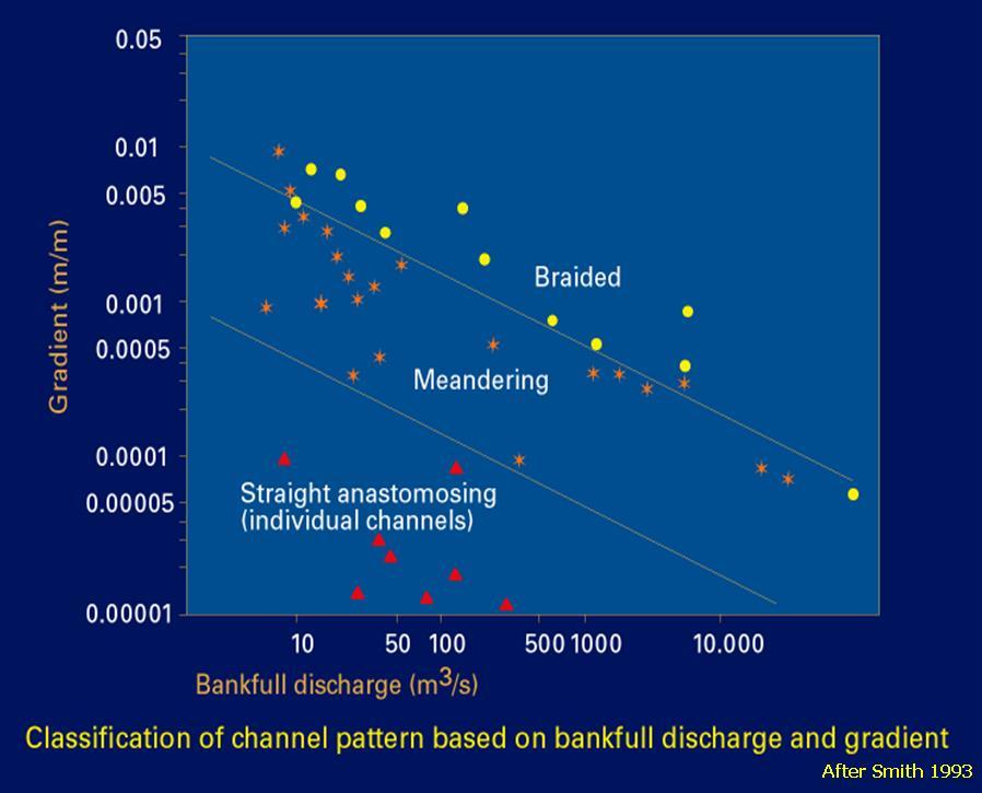
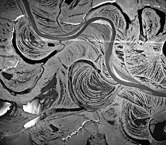
3 Fluvial Channel Patterns Henk Berendsen
... and also Regional slope Allocyclic controls such as tectonic tilt Flow duration?")
4 Meandering Braided Controlling factors Grain size Type of sediment load Fluid discharge Sediment discharge Discharge regularity Size of drainage area Bank stability (strength, vegetation)... and also Regional slope Allocyclic controls such as tectonic tilt Flow duration? Orton & Reading (1993)

5 Henk Berendsen

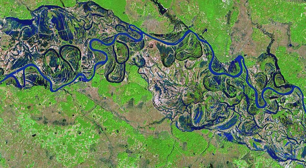
6 But how complex are channel patterns?

7 Braided or meandering river? i.e. its not as simple as this!!!
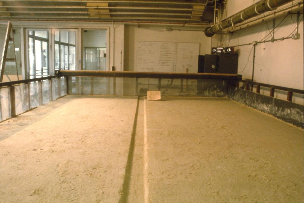
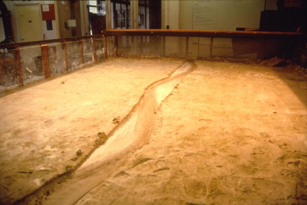
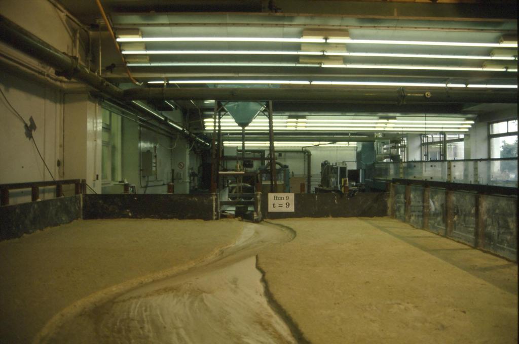
8 Meander Development movie
9
10
11
12 Channels, bars and smaller-scale bedforms ( for all types of rivers..) Small-scale bedforms: e.g. ripples, dunes, uspb, antidunes, bedload sheets. Bars: bed form with length proportional to local channel width and height proportional to channel depth. Simple (Unit) and compound (e.g. point, braid) bars Channels: different orders first (biggest) second..third
13 Fluvial form and stratasets: types and scales Ripples Dunes Low-relief bedwaves on plane beds Antidunes Seasonal flood deposit Unit bars and compound bars Channels Channel belt composed of channels and bars channel fills Floodplain with levees, crevasse splays, channels, lakes, floodbasins Alluvial valley with channel belts and floodplain (or fan or delta) Alluvial river system Small-scale cross stratasets Medium-scale cross stratasets Planar stratasets Low-angle cross stratasets Large-scale (inclined) stratum Large-scale inclined stratasets Channel fills Group of large-scale inclined stratasets and Groups of large-scale inclined stratasets and channel fills Groups of groups: alluvial architecture Basin fill (or part of basin fill)
14 Bridge and Demicco, 2008
15 Bridge, 2006

16 Basic flow in bends Boggs Ch. 8

17 Jorge Abad UIUC

18 The classic facies model for meandering river distal floodplain mud with roots, desiccation cracks, etc. proximal floodplain mud with occasional overbank sand ripple x-lamination and upper stage plane-bed lamination of upper point bar dune trough x-bedding and upper stage plane-bed lamination of lower point bar coarse channel lag deposit Walker (1979)

19 Lateral Accretion characteristics.
20 Preserved Jurassic bend deposits

21 Ph. 2 - site 1 Scroll bars and exposed Jurassic meander bends S
22 Types of cut-off of meander loops AVULSION thin muddy fill gradual abandonment via swale thick muddy fill rapid abandonment via cut bank sand plug Walker & Cant (1984)

23 Meandering river Summary of nomenclature POINT BAR SUBAQUEOUS DUNES CUT BANK RIPPLES SCROLL BARS Sinuosity = total channel length / meander-belt axial length

24 Williams River, Alaska (photo Norm Smith)
25
26
27 Overbank deposits and crevasse splays Sediment-laden flows forming thin sheets/wedges of fine-grained sandstones with characteristic sequences of structures Bridge and Demicco, 2008


28 Overbank deposits: organics, soils and trace fossils Norm Smith Tor Tornqvist Bridge, 2006
29 Overbank deposits and crevasse splays Bristow et al. (1999) Niobrara River

30 Overbank deposits and crevasse splays
31 Styles of bend migration
32 LATERAL ACCRETION SURFACES Bend Migration and Section Orientation (Willis, 1989) Expansion Translation Rotation Wavelength change
33 A point bar is a complex 3D sediment body so the expression of lateral accretion surfaces in outcrop depends on the orientation of the outcrop Let s examine different computer-simulated cross-sections of point bar deposits formed by translating and expanding meander bends Meanders in other environments?
")
34 Down-valley translating meander bends Lateral-accretion bedset surfaces correspond to migration steps Stippled lines denote lines of equal mean grain size Arrows denote local flow directions (up = into section, down = out of section)


35 Expanding meander bends Same simulation parameters as in previous example 35
36 For other section orientations and combined meander bend translation and expansion, see: Willis, B.J. (1989) Paleochannel reconstructions from point bar deposits: a three-dimensional perspective. Sedimentology, 36, Where can we use this information for? Reconstruction of the geometry of ancient point bars and meandering channel Reconstruction of the course of palaeochannel Reconstruction of the type(s) of meander bed migration
37 Finally, paleohydraulics: empirical relationships between meandering river parameters and flow discharge (for sinuosities > 1.7) = 106 Q 0.46 = 10.9 w 1.01 Q = mean annual discharge = meander wavelength w = channel width w = 6.8 h 1.54 h = channel depth
38 Summary Stratasets and formative bedforms Bend flow processes The classic meandering rivers facies model Complications and additions to this model (cutoff, floodplain, migration pattern etc) Preservation and orientation of sections Is there a definitive meandering river facies? Reading: B&D: Chapter 13 Nichols: Chapter 9 Boggs: Chapter 8 Bridge: Chapter 3 in Facies Models Revisited Leeder: Chapter 17 Bridge: Rivers and Floodplains textbook
Chapter 8: Learning objectives
 Chapter 8: Learning objectives Understand concept of sedimentary facies Signinifance of lateral and vertical facies associations Walther s Law Understand the sedimentary facies of alluvial fans, eolian
GLG362/GLG598 Geomorphology K. Whipple October, 2009 I. Characteristics of Alluvial Channels
 I. Characteristics of Alluvial Channels Self-formed morphology set by entrainment, transport, and deposition They move unconsolidated sedimentary materials present in the valley fill flood plain/bank flow
The Hydrologic Cycle
 CONTINENTAL DEPOSITIONAL ENVIRONMENTS fluvial desert lacustrine (lake) Glacial KEY PARAMETERS (VARIABLES) 1. Climate (Hydrologic Cycle) Annual Precip vs. Seasonality 2. Tectonics (Mountains) The Hydrologic
GY 402: Sedimentary Petrology
 UNIVERSITY OF SOUTH ALABAMA GY 402: Sedimentary Petrology Lecture 17: Sandy Fluvial Depositional Environments Instructor: Dr. Douglas W. Haywick Last Time Volcaniclastic Sedimentary Rocks 1. Origin of
River floodplain regime and stratigraphy. Drs. Nanette C. Kingma.
 River floodplain regime and stratigraphy. Drs. Nanette C. Kingma. Formation of floodplain. Formation of floodplains: lateral channel migration in channel deposition suspended-load fall out during higher
FLUVIAL LANDFORMS. Floodplains
 FLUVIAL LANDFORMS Floodplains fairly flat & continuous surface occupying much of a valley bottom normally underlain by unconsolidated sediments subject to periodic flooding (usually once every year or
NAME: GEL 109 Final Study Guide - Winter 2008 Questions 6-24 WILL be on the final exactly as written here; this is 60% of the test.
 GEL 109 Final Study Guide - Winter 2008 Questions 6-24 WILL be on the final exactly as written here; this is 60% of the test. 1. Sketch a map view of three types of deltas showing the differences in river,
Deep Water Systems and Sequence Stratigraphy. By: Matt Kyrias, Chris Majerczyk, Nick Whitcomb, Wesley Vermillion
 Deep Water Systems and Sequence Stratigraphy By: Matt Kyrias, Chris Majerczyk, Nick Whitcomb, Wesley Vermillion Contents Gravity Flow Depositional Elements Defined References NOTE: Source uses seismic
Stochastic Simulation of Inclined Heterolithic Stratification with Streamline-based Stochastic Models
 Stochastic Simulation of Inclined Heterolithic Stratification with Streamline-based Stochastic Models Michael J. Pyrcz and Clayton V. Deutsch Department of Civil and Environmental Engineering, University
GEOL 440 Sedimentology and stratigraphy: processes, environments and deposits Lectures 16 & 17: Deltaic Facies
 GEOL 440 Sedimentology and stratigraphy: processes, environments and deposits Lectures 16 & 17: Deltaic Facies What controls morphology and facies of the Nile Delta? Basic processes Classification Facies
Continental Environments. Continental Environments. Chapter 9. Deserts Alluvial fans Rivers (fluvial) and floodplains Lakes (lacustrine) Glacial
 and floodplains Lakes (lacustrine) Glacial") Continental Environments Chapter 9 Continental Environments Deserts Alluvial fans Rivers (fluvial) and floodplains Lakes (lacustrine) Glacial Desert Biome http://www.blueplanetbiomes.org/climate.htm low-latitude
Continental Environments Chapter 9 Continental Environments Deserts Alluvial fans Rivers (fluvial) and floodplains Lakes (lacustrine) Glacial Desert Biome http://www.blueplanetbiomes.org/climate.htm low-latitude
ES120 Sedimentology/Stratigraphy
 Midterm Exam 5/05/08 NAME: 1. List or describe 3 physical processes that contribute to the weathering of rocks (3pts). exfoliation frost wedging many others. roots, thermal expansion/contraction also credit
Geo 302D: Age of Dinosaurs. LAB 2: Sedimentary rocks and processes
 Geo 302D: Age of Dinosaurs LAB 2: Sedimentary rocks and processes Last week we covered the basic types of rocks and the rock cycle. This lab concentrates on sedimentary rocks. Sedimentary rocks have special
GY 111: Physical Geology
 UNIVERSITY OF SOUTH ALABAMA GY 111: Physical Geology Lecture 14: Sedimentary Rocks Part 2: Alluvial Fans and Rivers Instructor: Dr. Douglas W. Haywick Last Time 1) Types of Sediment 2) Sedimentary Rock
DOWNSTREAM SORTING OF SEDIMENT (additional control on channel width, depth and slope)
") DOWNSTREAM SORTING OF SEDIMENT (additional control on channel width, depth and slope) Image removed due to copyright concerns As the gravel gets finer, it is transported at lower slopes. The result is
DOWNSTREAM SORTING OF SEDIMENT (additional control on channel width, depth and slope) Image removed due to copyright concerns As the gravel gets finer, it is transported at lower slopes. The result is
Luca Giacomo Costamagna. Journal of Mediterranean Earth Sciences
 doi: 10.3304/JMES.2018.003 Journal of Mediterranean Earth Sciences 10 (2018), 129-134 Journal of Mediterranean Earth Sciences Investigation methods on continental outcrops: developing an upgrade of the
Sedimentary System Characteristics of Deng-3 Section on Paleo-central. Uplift Belt in Northern Songliao Basin. Siyang Li1,a*
 Sedimentary System Characteristics of Deng-3 Section on Paleo-central Uplift Belt in Northern Songliao Basin Siyang Li1,a* 1 School of Earth Sciences and Resources, China University of Geosciences, Beijing,
Erosion Surface Water. moving, transporting, and depositing sediment.
 + Erosion Surface Water moving, transporting, and depositing sediment. + Surface Water 2 Water from rainfall can hit Earth s surface and do a number of things: Slowly soak into the ground: Infiltration
Data Repository item
 Data Repository (B25407): Localities and descriptions of measured sections of study areas Table 1. Localities of the measured sedimentary sections in the NW Sichuan Basin Section Number Stratigraphy Locality
A floodplain is the flat land immediately surrounding a stream channel and innundated at 5mes of high flow.
 A floodplain is the flat land immediately surrounding a stream channel and innundated at 5mes of high flow. Aggrada5on occurs when deposi5on is greater than erosion. Aggrada&on of the Rivière des Ha! Ha!
Outcrops from Every Continent and 20 Countries in 140 Contributions. Tor H. Nilsen, Roger D. Shew, Gary S. Steffens, and Joseph R.J. Studlick.
 Paper VIII Tor H. Nilsen, Roger D. Shew, Gary S. Steffens, and Joseph R.J. Studlick Editors Outcrops from Every Continent and 20 Countries in 140 Contributions http://bookstore.aapg.org Length ~ 23 m (75.5
GEL 109 Midterm W05, Page points total (1 point per minute is a good pace, but it is good to have time to recheck your answers!
 GEL 109 Midterm W05, Page 1 50 points total (1 point per minute is a good pace, but it is good to have time to recheck your answers!) 1. Are the following flow types typically laminar or turbulent and
SUPPLEMENTAL INFORMATION DELFT 3-D MODELING: MODEL DESIGN, SETUP, AND ANALYSIS
 GSA DATA REPOSITORY 2014069 Hajek and Edmonds SUPPLEMENTAL INFORMATION DELFT 3-D MODELING: MODEL DESIGN, SETUP, AND ANALYSIS Each experiment starts from the initial condition of a straight channel 10 km
Running Water Earth - Chapter 16 Stan Hatfield Southwestern Illinois College
 Running Water Earth - Chapter 16 Stan Hatfield Southwestern Illinois College Hydrologic Cycle The hydrologic cycle is a summary of the circulation of Earth s water supply. Processes involved in the hydrologic
Streams. Stream Water Flow
 CHAPTER 14 OUTLINE Streams: Transport to the Oceans Does not contain complete lecture notes. To be used to help organize lecture notes and home/test studies. Streams Streams are the major geological agents
GEOL 1121 Earth Processes and Environments
 GEOL 1121 Earth Processes and Environments Wondwosen Seyoum Department of Geology University of Georgia e-mail: seyoum@uga.edu G/G Bldg., Rm. No. 122 Seyoum, 2015 Chapter 6 Streams and Flooding Seyoum,
Morphology and Sedimentology of Panther Creek, Montgomery County Preserve
 Morphology and Sedimentology of Panther Creek, Montgomery County Preserve, Ph.D. Houston, Texas February, 2014 This guide is for educational use. The author gives permission to reproduce this guide for
Earth Science Chapter 6 Section 2 Review
 Name: Class: Date: Earth Science Chapter 6 Section Review Multiple Choice Identify the choice that best completes the statement or answers the question. 1. Most streams carry the largest part of their
Sediment and sedimentary rocks Sediment
 Sediment and sedimentary rocks Sediment From sediments to sedimentary rocks (transportation, deposition, preservation and lithification) Types of sedimentary rocks (clastic, chemical and organic) Sedimentary
Seismic Expressions of Submarine Channel - Levee Systems and Their Architectural Elements
 Seismic Expressions of Submarine Channel - Levee Systems and Their Architectural Elements Summary D.V. Ramana, Santanu De* and Kalyanbrata Datta KDMIPE, ONGC, Dehradun E-mail- devvenram@rediffmail.com
Depositional Environment
 Depositional Environment Sedimentary depositional environment describes the combination of physical, chemical and biological processes associated with the deposition of a particular type of sediment. Types
Evidence of a Sandy Suspended-Load Dominated River from the Mississippian Cypress Formation, Illinois, USA
 Evidence of a Sandy Suspended-Load Dominated River from the Mississippian Cypress Formation, Illinois, USA Kalin Howell 1, Nathan Webb 2, Jim Best 1,3, Eric Prokocki 1,4 1 Department of Geology, University
Depositional Environments. Depositional Environments
 Depositional Environments Geographic area in which sediment is deposited Characterized by a combination of geological process & environmental conditions Depositional Environments Geological processes:
3/3/2013. The hydro cycle water returns from the sea. All "toilet to tap." Introduction to Environmental Geology, 5e
 Introduction to Environmental Geology, 5e Running Water: summary in haiku form Edward A. Keller Chapter 9 Rivers and Flooding Lecture Presentation prepared by X. Mara Chen, Salisbury University The hydro
Aquifer an underground zone or layer of sand, gravel, or porous rock that is saturated with water.
 Aggradation raising of the streambed by deposition that occurs when the energy of the water flowing through a stream reach is insufficient to transport sediment conveyed from upstream. Alluvium a general
NATURAL RIVER. Karima Attia Nile Research Institute
 NATURAL RIVER CHARACTERISTICS Karima Attia Nile Research Institute NATURAL RIVER DEFINITION NATURAL RIVER DEFINITION Is natural stream of water that flows in channels with ih more or less defined banks.
Bulletin of Earth Sciences of Thailand
 Depositional Environments and Stratigraphic Development of the Grand Taman Sari Circuit Outcrop: an Analogue for Transgressive Mahakam Delta Successions Ridha Santika Riadi Petroleum Geoscience Program,
Lab Final Review 4/16/18
 Lab Final Review 4/16/18 Overall goals from lab Think about geology on recent timescales, predict the direction change Be able to identify how different landforms or patterns (e.g. drainage patterns, dune
Lectures Hydrology & Fluvial Geomorphology. Gauley River Images. Ancients' (= Biblical) Model of Water (Hydrologic) Cycle
 Model of Water (Hydrologic) Cycle") Lectures 11-13 13 Hydrology & Fluvial Geomorphology Gauley River Images http://www.youtube.com/watch?v=eulmuyegtz4&feature=related Ancients' (= Biblical) Model of Water (Hydrologic) Cycle Stream Water
Lectures 11-13 13 Hydrology & Fluvial Geomorphology Gauley River Images http://www.youtube.com/watch?v=eulmuyegtz4&feature=related Ancients' (= Biblical) Model of Water (Hydrologic) Cycle Stream Water
Surface Water and Stream Development
 Surface Water and Stream Development Surface Water The moment a raindrop falls to earth it begins its return to the sea. Once water reaches Earth s surface it may evaporate back into the atmosphere, soak
The San Benito Gravels: Fluvial Depositional Systems, Paleocurrents, and Provenance
 ES120 FIELD TRIP #2 10 April 2010 NAME: The San Benito Gravels: Fluvial Depositional Systems, Paleocurrents, and Provenance Introduction The San Benito Gravels (SBG) consists of a 500 m thick section of
EROSION, DEPOSITION AND SEDIMENTARY ROCKS. Reading: Earth Science Tarbuck and Lutgens Chapter 5: pages Chapter 3: pages 52-54, 61-69
 EROSION, DEPOSITION AND SEDIMENTARY ROCKS Reading: Earth Science Tarbuck and Lutgens Chapter 5: pages 124-133 Chapter 3: pages 52-54, 61-69 Base Level Resistant bed Resistant bed creates a local base level
FEMA. GEOL 440 Sedimentology and stratigraphy: processes, environments and deposits
 Lecture 11: Alluvial Fan Facies FEMA GEOL 440 Sedimentology and stratigraphy: processes, environments and deposits Debris-flow and flooding hazards associated with the December 1999 storm in coastal Venezuela
LAB-SCALE INVESTIGATION ONBAR FORMATION COORDINATES IN RIVER BASED ON FLOW AND SEDIMENT
 LAB-SCALE INVESTIGATION ONBAR FORMATION COORDINATES IN RIVER BASED ON FLOW AND SEDIMENT Mat Salleh M. Z., Ariffin J., Mohd-Noor M. F. and Yusof N. A. U. Faculty of Civil Engineering, University Technology
UNIVERSITY OF SZEGED Faculty of Science Doctorate School of Earth Sciences Department of Physical Geography and Geoinformatics
 UNIVERSITY OF SZEGED Faculty of Science Doctorate School of Earth Sciences Department of Physical Geography and Geoinformatics INVESTIGATION OF PAST AND PRESENT FLUVIAL FORMS AND PROCESSES ALONG THE LOWLAND
Chapter 5. The Sedimentary Archives
 Chapter 5 The Sedimentary Archives Factors affecting Sedimentary Characteristics 1. Tectonic setting 2. Physical, chemical, and biological processes in the depositional environment 3. Method of sediment
GEOL 652. Poudre River Fieldtrip
 GEOL 652. Poudre River Fieldtrip One of the more difficult variables to measure and/or estimate when studying flow in natural channels is that of roughness. Roughness, usually approximated with Manning
LATERAL MIGRATION of ALLUVIAL CHANNELS
 LATERAL MIGRATION of ALLUVIAL CHANNELS Pierre Y. Julien Colorado State University Santiago del Estero, Argentina November 2011 1 1 Objectives Discuss the lateral migration of alluvial channels and provide
Final Exam. Running Water Erosion and Deposition. Willamette Discharge. Running Water
 Final Exam Running Water Erosion and Deposition Earth Science Chapter 5 Pages 120-135 Scheduled for 8 AM, March 21, 2006 Bring A scantron form A calculator Your 3 x 5 paper card of formulas Review questions
Upper Truckee River Restoration Lake Tahoe, California Presented by Brendan Belby Sacramento, California
 Upper Truckee River Restoration Lake Tahoe, California Presented by Brendan Belby Sacramento, California Mike Rudd (Project Manager), Charley Miller & Chad Krofta Declines in Tahoe s Water Clarity The
EARTH SURFACE PROCESSES AND SEDIMENTATION!
 Sed and Strat EARTH SURFACE PROCESSES AND SEDIMENTATION! 2/27 Lecture 7- Exposure: Weathering and the Sediment Factory 3/04 Lecture 8 - Rivers and Landscapes 3/06 Lecture 9 - Waves (not Tides) 3/11 Lecture
Stream Entrainment, Erosion, Transportation & Deposition
 Lecture 12 Zone 2 of the Fluvial System, Continued Stream Entrainment, Erosion, Transportation & Deposition Erosion in a Fluvial Landscape Corrosion Chemical Erosion Corrasion Mechanical Weathering Cavitation
GEL 109 Midterm W01, Page points total (1 point per minute is a good pace, but it is good to have time to recheck your answers!
 GEL 109 Midterm W01, Page 1 50 points total (1 point per minute is a good pace, but it is good to have time to recheck your answers!) 1. Where in a water flow is there usually a zone of laminar flow even
Fluvial Reservoirs: Using the Right Architectural Models*
 Fluvial Reservoirs: Using the Right Architectural Models* G.J. Nichols 1, A.J. Hartley 2, G.S. Weissmann 3, L.A. Scuderi 3, and S.K. Davidson 2 Search and Discovery Article #50571 (2012) Posted February
Holocene Lower Mississippi River Avulsions: Autogenic Versus Allogenic Forcing*
 Holocene Lower Mississippi River Avulsions: Autogenic Versus Allogenic Forcing* Eric Prokocki 1,2 Search and Discovery Article #50330 (2010) Posted October 14, 2010 *Adapted from oral presentation at AAPG
11/12/2014. Running Water. Introduction. Water on Earth. The Hydrologic Cycle. Fluid Flow
 Introduction Mercury, Venus, Earth and Mars share a similar history, but Earth is the only terrestrial planet with abundant water! Mercury is too small and hot Venus has a runaway green house effect so
Facies Analysis Of The Reservoir Rocks In The. Sylhet Trough, Bangladesh. Abstract
 Facies Analysis Of The Reservoir Rocks In The Sylhet Trough, Bangladesh Joyanta Dutta Petroleum Geoscience Program, Department of Geology, Faculty of Science, Chulalongkorn University, Bangkok 10330, Thailand
Rivers and Landslides
 Rivers and Landslides Path of desire or path of least resistance? Desire Path: A term in landscape architecture used to describe a path that isn t designed but rather is worn casually away by people finding
The Overall Objectives of Proposed Study
 Eric Prokocki is currently working on a Ph.D. degree at The University of Illinois. His advisor is Dr. Gary Proctor. His research project is related to Holocene evolution and avulsion dynamics of the lower
Environmental Geology Chapter 9 Rivers and Flooding
 Environmental Geology Chapter 9 Rivers and Flooding Flooding in Pakistan 2010-1600 killed/20000 affected The hydrologic cycle is powered by the Sun The cycle includes evaporation, precipitation, infiltration,
Fluid-Mud Deposits of the Lower Jurassic Tilje Formation, Offshore Mid-Norway By Aitor A. Ichaso and Robert W. Dalrymple 1
 Fluid-Mud Deposits of the Lower Jurassic Tilje Formation, Offshore Mid-Norway By Aitor A. Ichaso and Robert W. Dalrymple 1 Search and Discovery Article #50107 (2008) Posted August 10, 2008 *Adapted from
Alluvial architecture of fluvio-deltaic successions: a review with special reference to Holocene settings
 Netherlands Journal of Geosciences Geologie en Mijnbouw 86 3 211-227 27 Alluvial architecture of fluvio-deltaic successions: a review with special reference to Holocene settings M.J.P. Gouw Department
The Nature of Sedimentary Rocks
 The Nature of Sedimentary Rocks Sedimentary rocks are composed of: Fragments of other rocks Chemical precipitates Organic matter or biochemically produced materials The Nature of Sedimentary Rocks Sedimentary
Figure 1. Map of Feather River Basin in northern California. (A) Region straddles the northwestern Sierra Nevada and Sacramento Valley.
 Region straddles the northwestern Sierra Nevada and Sacramento Valley.") Figure 1. Map of Feather River Basin in northern California. (A) Region straddles the northwestern Sierra Nevada and Sacramento Valley. (B) Feather River Basin with Yuba and Bear subbasins. Most hydraulic
Figure 1. Map of Feather River Basin in northern California. (A) Region straddles the northwestern Sierra Nevada and Sacramento Valley. (B) Feather River Basin with Yuba and Bear subbasins. Most hydraulic
STUDY GUIDE FOR CONTENT MASTERY. Surface Water Movement
 Surface Water SECTION 9.1 Surface Water Movement In your textbook, read about surface water and the way in which it moves sediment. Complete each statement. 1. An excessive amount of water flowing downslope
GY 111 Lecture Note Series Sedimentary Environments 2: Rivers and Deltas
 GY 111 Lecture Notes D. Haywick (2008-09) 1 GY 111 Lecture Note Series Sedimentary Environments 2: Rivers and Deltas Lecture Goals A) Rivers and Deltas (types) B) Water Flow and sedimentation in river/deltas
Modeling of Intra-Channel Belt Depositional Architecture in Fluvial Reservoir Analogs from the Lourinha Formation, Portugal*
 Modeling of Intra-Channel Belt Depositional Architecture in Fluvial Reservoir Analogs from the Lourinha Formation, Portugal* Anneli Ekeland 1, Nina Pedersen 1, John Howell 1, Wojtek Nemec 2, Kevin Keogh
GeoCanada 2010 Working with the Earth
 Lithofacies Identification and the Implications for SAGD Well Planning in the McMurray Formation, Christina Lake Area, Alberta Travis Shackleton*, Robert Gardner, Sung Youn, Grace Eng and Lori Barth Cenovus
PHYSICAL GEOGRAPHY. By Brett Lucas
 PHYSICAL GEOGRAPHY By Brett Lucas FLUVIAL PROCESSES Fluvial Processes The Impact of Fluvial Processes on the Landscape Streams and Stream Systems Stream Channels Structural Relationships The Shaping and
Fresh Water: Streams, Lakes Groundwater & Wetlands
 Fresh Water:, Lakes Groundwater & Wetlands Oct 27 Glaciers and Ice Ages Chp 13 Nov 3 Deserts and Wind and EXAM #3 Slope hydrologic cycle P = precip I = precip intercepted by veg ET = evapotranspiration
Landscape Development
 Landscape Development Slopes Dominate Natural Landscapes Created by the interplay of tectonic and igneous activity and gradation Deformation and uplift Volcanic activity Agents of gradation Mass wasting
Archimetrics: a quantitative tool to predict threedimensional meander belt sandbody heterogeneity
 The journal of the International Association of Sedimentologists ORIGINAL RESEARCH ARTICLE Archimetrics: a quantitative tool to predict threedimensional meander belt sandbody heterogeneity WIETSE I. VAN
Sediment and Sedimentary rock
 Sediment and Sedimentary rock Sediment: An accumulation of loose mineral grains, such as boulders, pebbles, sand, silt or mud, which are not cemented together. Mechanical and chemical weathering produces
Relationship between River-mouth Depositional Processes and Delta Architectures, Huangqihai Lake, Inner Mongolia, North China*
 Relationship between River-mouth Depositional Processes and Delta Architectures, Huangqihai Lake, Inner Mongolia, North China* Shunli Li 1,3, Xinghe Yu 2, Shengli Li 2, Cornel Olariu 3, and Ronald Steel
Lunt, I. A. 1, G. H. Sambrook Smith 2*, J. L. Best 3, P. J. Ashworth 4, S. N. Lane 5, and C. J. Simpson 6. Edgbaston, Birmingham, B15 2TT, U.K.
 1 DEPOSITS OF THE SANDY BRAIDED SOUTH SASKATCHEWAN RIVER: IMPLICATIONS FOR USING MODERN ANALOGUES TO RECONSTRUCT CHANNEL DIMENSIONS FOR USE IN RESERVOIR CHARACTERISATION Lunt, I. A. 1, G. H. Sambrook Smith
Rivers T. Perron
 1 Rivers T. Perron 12.001 After our discussions of large-scale topography, how we represent topography in maps, and how topography interacts with geologic structures, you should be frothing at the mouth
Stream Classification
 Stream Classification Why Classify Streams? Communication Tool Describe Existing Conditions & Trends Describe Restoration Goals Research Tool Morphologic Stream Classification Systems Schumm (1977) Alluvial
The Hydrologic Cycle STREAM SYSTEMS. Earth s Water and the Hydrologic Cycle. The Hydrologic Cycle. Hydrologic Cycle
 STREAM SYSTEMS Earth Science: Chapter 5 Reading pages 114-124 The Hydrologic Cycle Oceans not filling up Evaporation = precipitation System is balanced Earth s Water and the Hydrologic Cycle Earth s Water
Summary. Streams and Drainage Systems
 Streams and Drainage Systems Summary Streams are part of the hydrologic cycle and the chief means by which water returns from the land to the sea. They help shape the Earth s surface and transport sediment
Annotated Bibliography of River Avulsions Pat Dryer Geography 364 5/14/2007
 Annotated Bibliography of River Avulsions Pat Dryer Geography 364 5/14/2007 1 Table of Contents Introduction 2 Annotations I. River avulsions and their deposits 2 II. Channel avulsion on alluvial fans
Study on Bedforms and Lithofacies Structres and Interpretation of Depositional Environtment of Brahmaputra River near Nemati, Assam, India.
 The International Journal Of Engineering And Science (IJES) Volume 4 Issue 7 Pages PP -14-20 2015 ISSN (e): 2319 1813 ISSN (p): 2319 1805 Study on Bedforms and Lithofacies Structres and Interpretation
27. Running Water I (p ; )
") 27. Running Water I (p. 424-436; 440-444) Hydrosphere How much of the Earth s surface is covered by water? Earth's water is collectively called the and is stored in a number of so-called as follows: 1.
27. Running Water I (p. 424-436; 440-444) Hydrosphere How much of the Earth s surface is covered by water? Earth's water is collectively called the and is stored in a number of so-called as follows: 1.
Earth Science Chapter 9. Day 6 - Finish Capillary Action Lab - Quiz over Notes - Review Worksheets over Sections 9.2 and 9.3
 Earth Science Chapter 9 Day 1 Day 2 Day 3 Read Section 9.1 Surface Water Chapter 9 Term Sheet Notes over Section 9.1 Surface Water Section 9.1 Review Worksheets Quiz over Section 9.1 Notes Virtual Lab
Geo 302D: Age of Dinosaurs. LAB 1: Introduction to Rocks and Sedimentary Processes
 Geo 302D: Age of Dinosaurs LAB 1: Introduction to Rocks and Sedimentary Processes We would not be able to address the interesting questions of dinosaurs and their place in the history of life without the
Wetland & Floodplain Functional Assessments and Mapping To Protect and Restore Riverine Systems in Vermont. Mike Kline and Laura Lapierre Vermont DEC
 Wetland & Floodplain Functional Assessments and Mapping To Protect and Restore Riverine Systems in Vermont Mike Kline and Laura Lapierre Vermont DEC NWI+ Hydro-Geomorphic Characterization of Wetlands and
Nathan D. Webb and James L. Best
 Nathan D. Webb and James L. Best Background Pennsylvanian oil production Stratigraphy & geologic setting Study area Methods Using geophysical logs & core Results Comparing three channel deposits Implications
STREAM SYSTEMS and FLOODS
 STREAM SYSTEMS and FLOODS The Hydrologic Cycle Precipitation Evaporation Infiltration Runoff Transpiration Earth s Water and the Hydrologic Cycle The Hydrologic Cycle The Hydrologic Cycle Oceans not filling
Precipitation Evaporation Infiltration Earth s Water and the Hydrologic Cycle. Runoff Transpiration
 STREAM SYSTEMS and FLOODS The Hydrologic Cycle Precipitation Evaporation Infiltration Earth s Water and the Hydrologic Cycle Runoff Transpiration The Hydrologic Cycle The Hydrologic Cycle Oceans not filling
NAME: GEL 109 Final Winter 2010
 GEL 109 Final Winter 2010 1. The following stratigraphic sections represents a single event followed by the slow accumulation of background sedimentation of shale. Describe the flows that produced the
Alluvial Architecture and Fluvial Cycles in Quaternary Deposits in a Continental Interior Basin, E Hungary
 Geologia Croatica 57/2 171 190 13 Figs. ZAGREB 2004 Alluvial Architecture and Fluvial Cycles in Quaternary Deposits in a Continental Interior Basin, E Hungary Györgyi JUHÁSZ, Pál MÜLLER and Ágnes TÓTH-MAKK
Alluvial Stratigraphy in Otsego County
 Alluvial Stratigraphy in Otsego County Butternut Creek, 10/1/2010 A view from the river Les Hasbargen October 14, 2010 Overview Acknowledgements: Damon Matteson, Emily Carroll, Cindy Klink, Emmon Johnson
Aeolian Environments and Controls on Sedimentation. Alex Bryk, Ron Cash, Jacob Wikle, Rebecca Alberts
 Aeolian Environments and Controls on Sedimentation Alex Bryk, Ron Cash, Jacob Wikle, Rebecca Alberts Aeolian dunes develop in desert systems where there is an abundance of sand-grade material available
Accommodation. Tectonics (local to regional) Subsidence Uplift
 Subsidence Uplift") Accommodation Accommodation varies over time; it is the distance between a reference horizon and the sea surface (i.e. relative sea level). The space to be filled in with sediments or water What are the
Accommodation Accommodation varies over time; it is the distance between a reference horizon and the sea surface (i.e. relative sea level). The space to be filled in with sediments or water What are the
Stratigraphic modelling using CHILD
 5 Stratigraphic modelling using CHILD 5.1 Triangular irregular network Surface process models are widely used in geomorphology and geology, and the developments in the field follow each other rapidly.
GEOL 440 Sedimentology and stratigraphy: processes, environments and deposits. Lectures 17 & 18: Aeolian Facies
 GEOL 440 Sedimentology and stratigraphy: processes, environments and deposits Lectures 17 & 18: Aeolian Facies Today: Processes air/water differences Deposits bedforms Facies a little on models and controls
Bulletin of Earth Sciences of Thailand
 Quantitative Seismic Geomorphology of Early Miocene to Pleistocene Fluvial System of Northern Songkhla Basin, Gulf of Thailand Oanh Thi Tran Petroleum Geoscience Program, Department of Geology, Faculty
Lectures 6 & 7: Flow, bedforms and sedimentary structures in oscillatory and multidirectional flows
 GEOL 440 Sedimentology and stratigraphy: processes, environments and deposits Lectures 6 & 7: Flow, bedforms and sedimentary structures in oscillatory and multidirectional flows Today, aim to examine:
A Review of Some Fluvial Styles
 A Review of Some Fluvial Styles M. J. Pyrcz (mpyrcz@ualberta.ca) Department of Civil & Environmental Engineering University of Alberta Abstract Modern fluvial sedimentological studies classify fluvial
GEOS 302 Lab 3: Sedimentary Structures (Reference Boggs, Chap.4)
") GEOS 302 Lab 3: Sedimentary Structures (Reference Boggs, Chap.4) Objectives: 1. Become familiar with the different sedimentary structures 2. Understand the origin of these different structures and be able
GEOS 302 Lab 3: Sedimentary Structures (Reference Boggs, Chap.4) Objectives: 1. Become familiar with the different sedimentary structures 2. Understand the origin of these different structures and be able
ES 105 Surface Processes I. Hydrologic cycle A. Distribution % in oceans 2. >3% surface water a. +99% surface water in glaciers b.
 ES 105 Surface Processes I. Hydrologic cycle A. Distribution 1. +97% in oceans 2. >3% surface water a. +99% surface water in glaciers b. >1/3% liquid, fresh water in streams and lakes~1/10,000 of water