Deep Water Systems and Sequence Stratigraphy. By: Matt Kyrias, Chris Majerczyk, Nick Whitcomb, Wesley Vermillion
|
|
|
- Luke Campbell
- 6 years ago
- Views:
Transcription
1 Deep Water Systems and Sequence Stratigraphy By: Matt Kyrias, Chris Majerczyk, Nick Whitcomb, Wesley Vermillion


2 Contents Gravity Flow Depositional Elements Defined References NOTE: Source uses seismic data but that will not be at our disposal in Ireland. We ll try to explain to you what the different depositional environments look like in the field.


 the immediately")
3 Gravity-Flow Depositional Elements Turbidity-flow leveed channels Channel overbank sediment Distributary-channel complexes Crevasse-splay complexes Debris-flow channels, lobes, and sheets ALL elements characterized by direct deposition onto or into (through erosion) the immediately underlying substrate


4 Turbidity-Flow Leveed Channels: Basics Commonly form in slope and basin floor environments Widths range from m Wide range of sinuosity Channels meander downstream Extent of contact between sand-prone part of channel and levee is important

5 Turbidity-Flow Leveed Channels: Cont. Posamentier and Kolla, 2003

6 Channel Meander Loops Uniformitarianism? Deep water vs. alluvial systems Morphological similarities is a result of processes that involve dynamic interaction of flows, sediments, and terrain gradient

7 Meandering Channels & Avulsion Avulsion- a sudden cutting off of land by flood, currents, or change in course of a body of water. - Change in flow parameters associated with changes upslope or on the staging area. - Avulsion channels form systematically, beginning down-system and gradually forming further up-system. - Large-scale avulsion events are relatively rare, but where present may yield good reservoir lithologies.
8 Overbank/Levee Deposits - Associated with deep-water channels, and overbank flow out of adjacent channels. - Often an order of magnitude wider than their associated channel. - Flow directed away from the channel in close proximity to the levee crest. - Results in thickened section on the stoss side of the sediment waves - Levees characterized by sediment wave development, not present in other systems. - Contain reservoir-quality thin bedded sandstones.


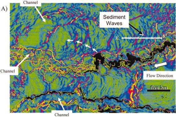
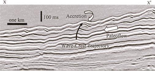
9 SEDIMENT WAVES

10 Frontal Splay Complexes A process of flaring out from a confined to unconfined system This causes lobate structures to form The transition from confined to unconfined can be related to a progressive lowering of levee height down system to where the high density part of the turbidity flow is no longer confined Such a shift of transition down system would be associated with a progressive overall grain size decrease

11 Frontal Splay Complex: Diagram
12 Frontal Splay Complex: Cont There is minimal loss of sand within these flows due to the high density part of the flow remains effectively confined by levee walls Down system there is a gradual increase of net sand deposited on levees, and as the system loses sand the levees loose height The high density part of the flow eventually breaks through the levee splaying out in a braided pattern. This also leads to channel avulsion

13 Crevasse and Overbank Splays Where the levee is breached crevasse splay complex form. This is similar to formation of avulsion channels. A network of channels form and produce sheet like sand rich deposits Debris flow: sheets, Lobes, and Channels Debris flows deposits have a common characteristic of long linear grooves that reflect the basal surface


14 Controls on Deep-Water Sedimentation Controls on the occurrence of sand-rich deepwater sedimentation The presence of sand in the shelf-margin staging area Steep slopes immediately after the staging area Sea-level falls sufficient to expose most of the shelf


15 Controls on Deep-Water Sedimentation: Cont Controls on the style of deep-water deposition Sand to mud ratio within the material delivered to the deep water Basin physiography Magnitude, duration, and frequency of depositional events Sediment delivery mechanisms Single source versus multiple smaller sources Rheology and concentration of sediment gravity flows Bottom-current activity


16 Sequence Stratigraphic Significance Typical deep-water sequence Debris-flow deposits at base Splay-complex-dominated turbidite deposits Period of sea-level fall Leveed-channel-dominated deposits Period of sea-level stillstand and slow rise Debris-flow deposits Capped by condensed-section deposits Posamentier and Kolla, 2003
17 Conclusions While the paper dealt mainly with seismic data, we discussed what could be relevant to Ireland. Turbidity-flow leveed channels, meander loops, overbank or levee deposits, frontal splay deposits, crevasse splays or overbank splays, and debris-flows were discussed. The controls on deep-water sedimentation were also discussed along with a general sequence stratigraphy.
18 References Posamentier, H. W. and Kolla, V. (2003). Seismic geomorphology and stratigraphy of depositional elements in deep water. Journal of Sedimentary Research. vol. 73 no
SEISMIC GEOMORPHOLOGY AND STRATIGRAPHY OF DEPOSITIONAL ELEMENTS IN DEEP-WATER SETTINGS
 SEISMIC GEOMORPHOLOGY AND STRATIGRAPHY OF DEPOSITIONAL ELEMENTS IN DEEP-WATER SETTINGS HENRY W. POSAMENTIER 1 AND VENKATARATHNAN KOLLA 2 1 Anadarko Petroleum Corporation, 425 1 st Street SW, Calgary, Alberta
Seismic Expressions of Submarine Channel - Levee Systems and Their Architectural Elements
 Seismic Expressions of Submarine Channel - Levee Systems and Their Architectural Elements Summary D.V. Ramana, Santanu De* and Kalyanbrata Datta KDMIPE, ONGC, Dehradun E-mail- devvenram@rediffmail.com
A Linked Shelf-Edge Delta and Slope-Channel Turbidite System: 3D Seismic Case Study from the Eastern Gulf of Mexico
 A Linked Shelf-Edge Delta and Slope-Channel Turbidite System: 3D Seismic Case Study from the Eastern Gulf of Mexico Posamentier, Henry W. Anadarko Canada Corporation 425 1 st Street SW Calgary, Alberta
27. Running Water I (p ; )
") 27. Running Water I (p. 424-436; 440-444) Hydrosphere How much of the Earth s surface is covered by water? Earth's water is collectively called the and is stored in a number of so-called as follows: 1.
27. Running Water I (p. 424-436; 440-444) Hydrosphere How much of the Earth s surface is covered by water? Earth's water is collectively called the and is stored in a number of so-called as follows: 1.
Prof Bryan T CRONIN Principal Geologist 2 Tullow Ghana Ltd
 Entrenched slope channel complex systems: Reservoir opportunities through understanding architectural element distribution and application to West Africa E&P Prof Bryan T CRONIN Principal Geologist 2 Tullow
River floodplain regime and stratigraphy. Drs. Nanette C. Kingma.
 River floodplain regime and stratigraphy. Drs. Nanette C. Kingma. Formation of floodplain. Formation of floodplains: lateral channel migration in channel deposition suspended-load fall out during higher
Lecture 19: Fluvial Facies
 GEOL 440 Sedimentology and stratigraphy: processes, environments and deposits Lecture 19: Fluvial Facies Aims Examine controls on alluvial channel pattern List the types of channel pattern Examine meandering
Outcrops from Every Continent and 20 Countries in 140 Contributions. Tor H. Nilsen, Roger D. Shew, Gary S. Steffens, and Joseph R.J. Studlick.
 Paper VIII Tor H. Nilsen, Roger D. Shew, Gary S. Steffens, and Joseph R.J. Studlick Editors Outcrops from Every Continent and 20 Countries in 140 Contributions http://bookstore.aapg.org Length ~ 23 m (75.5
The 3-D Seismic Geomorphology of Deep-Water Slope Channel Systems A Case Study from the Deep Water Nile Delta
 Geological Society of Trinidad & Tobago The 3-D Seismic Geomorphology of Deep-Water Slope Channel Systems A Case Study from the Deep Water Nile Delta Nigel E. Cross Presentation Outline Introduction Deep
Depositional elements associated with a basin floor channel-levee system: case study from the Gulf of Mexico
 Marine and Petroleum Geology 20 (2003) 677 690 www.elsevier.com/locate/marpetgeo Depositional elements associated with a basin floor channel-levee system: case study from the Gulf of Mexico Henry W. Posamentier
Interpreting deepwater sedimentary facies using borehole images: a case study of Tertiary deepwater deposits from Godavari Basin, East Coast of India
 P - 415 Interpreting deepwater sedimentary facies using borehole images: a case study of Tertiary deepwater deposits from Godavari Basin, East Coast of India Ashish Kundu, Sudipta Dasgupta*, Neeraj Sinha,
Search and Discovery Article #40536 (2010) Posted June 21, 2010
 Posted June 21, 2010") Modern Examples of Mass Transport Complexes, Debrite and Turbidite Associations: Geometry, Stratigraphic Relationships and Implications for Hydrocarbon Trap Development* Fabiano Gamberi 1, Marzia Rovere
Modern Examples of Mass Transport Complexes, Debrite and Turbidite Associations: Geometry, Stratigraphic Relationships and Implications for Hydrocarbon Trap Development* Fabiano Gamberi 1, Marzia Rovere
Erosion Surface Water. moving, transporting, and depositing sediment.
 + Erosion Surface Water moving, transporting, and depositing sediment. + Surface Water 2 Water from rainfall can hit Earth s surface and do a number of things: Slowly soak into the ground: Infiltration
The Hydrologic Cycle
 CONTINENTAL DEPOSITIONAL ENVIRONMENTS fluvial desert lacustrine (lake) Glacial KEY PARAMETERS (VARIABLES) 1. Climate (Hydrologic Cycle) Annual Precip vs. Seasonality 2. Tectonics (Mountains) The Hydrologic
Summary. Streams and Drainage Systems
 Streams and Drainage Systems Summary Streams are part of the hydrologic cycle and the chief means by which water returns from the land to the sea. They help shape the Earth s surface and transport sediment
Use of Cellular Automata Flow Model in the Hybrid Geostatistical Models: A Proposal
 Use of Cellular Automata Flow Model in the Hybrid Geostatistical Models: A Proposal Siyao Xu and Tapan Mukerji Graduate Program in Earth, Energy and Environmental Sciences Stanford University Abstract
Sequence Stratigraphy. Historical Perspective
 Sequence Stratigraphy Historical Perspective Sequence Stratigraphy Sequence Stratigraphy is the subdivision of sedimentary basin fills into genetic packages bounded by unconformities and their correlative
A floodplain is the flat land immediately surrounding a stream channel and innundated at 5mes of high flow.
 A floodplain is the flat land immediately surrounding a stream channel and innundated at 5mes of high flow. Aggrada5on occurs when deposi5on is greater than erosion. Aggrada&on of the Rivière des Ha! Ha!
SUPPLEMENTAL INFORMATION DELFT 3-D MODELING: MODEL DESIGN, SETUP, AND ANALYSIS
 GSA DATA REPOSITORY 2014069 Hajek and Edmonds SUPPLEMENTAL INFORMATION DELFT 3-D MODELING: MODEL DESIGN, SETUP, AND ANALYSIS Each experiment starts from the initial condition of a straight channel 10 km
DOWNSTREAM SORTING OF SEDIMENT (additional control on channel width, depth and slope)
") DOWNSTREAM SORTING OF SEDIMENT (additional control on channel width, depth and slope) Image removed due to copyright concerns As the gravel gets finer, it is transported at lower slopes. The result is
DOWNSTREAM SORTING OF SEDIMENT (additional control on channel width, depth and slope) Image removed due to copyright concerns As the gravel gets finer, it is transported at lower slopes. The result is
Chapter 8: Learning objectives
 Chapter 8: Learning objectives Understand concept of sedimentary facies Signinifance of lateral and vertical facies associations Walther s Law Understand the sedimentary facies of alluvial fans, eolian
Final Exam. Running Water Erosion and Deposition. Willamette Discharge. Running Water
 Final Exam Running Water Erosion and Deposition Earth Science Chapter 5 Pages 120-135 Scheduled for 8 AM, March 21, 2006 Bring A scantron form A calculator Your 3 x 5 paper card of formulas Review questions
NATURAL RIVER. Karima Attia Nile Research Institute
 NATURAL RIVER CHARACTERISTICS Karima Attia Nile Research Institute NATURAL RIVER DEFINITION NATURAL RIVER DEFINITION Is natural stream of water that flows in channels with ih more or less defined banks.
11/12/2014. Running Water. Introduction. Water on Earth. The Hydrologic Cycle. Fluid Flow
 Introduction Mercury, Venus, Earth and Mars share a similar history, but Earth is the only terrestrial planet with abundant water! Mercury is too small and hot Venus has a runaway green house effect so
Riparian Assessment. Steps in the right direction... Drainage Basin/Watershed: Start by Thinking Big. Riparian Assessment vs.
 Riparian Assessment vs. Monitoring Riparian Assessment What is a healthy stream? Determine stream/riparian health Determine change or trend, especially in response to mgmt Classification = designation
ES 105 Surface Processes I. Hydrologic cycle A. Distribution % in oceans 2. >3% surface water a. +99% surface water in glaciers b.
 ES 105 Surface Processes I. Hydrologic cycle A. Distribution 1. +97% in oceans 2. >3% surface water a. +99% surface water in glaciers b. >1/3% liquid, fresh water in streams and lakes~1/10,000 of water
Bulletin of Earth Sciences of Thailand
 Depositional Environments and Stratigraphic Development of the Grand Taman Sari Circuit Outcrop: an Analogue for Transgressive Mahakam Delta Successions Ridha Santika Riadi Petroleum Geoscience Program,
GY 111 Lecture Note Series Sedimentary Environments 2: Rivers and Deltas
 GY 111 Lecture Notes D. Haywick (2008-09) 1 GY 111 Lecture Note Series Sedimentary Environments 2: Rivers and Deltas Lecture Goals A) Rivers and Deltas (types) B) Water Flow and sedimentation in river/deltas
Streams. Water. Hydrologic Cycle. Geol 104: Streams
 Streams Why study streams? Running water is the most important geologic agent in erosion, transportation and deposition of sediments. Water The unique physical and chemical properties of water make it
Sedimentary System Characteristics of Deng-3 Section on Paleo-central. Uplift Belt in Northern Songliao Basin. Siyang Li1,a*
 Sedimentary System Characteristics of Deng-3 Section on Paleo-central Uplift Belt in Northern Songliao Basin Siyang Li1,a* 1 School of Earth Sciences and Resources, China University of Geosciences, Beijing,
Teacher s Pack Key Stage 3 GEOGRAPHY
 Teacher s Pack Key Stage 3 GEOGRAPHY Geography Key Stage 3 Fieldwork Worksheet Rivers: 1. Is the water fresh or salty? (test its resistance or specific gravity) 2. Do you know where the water is coming
Rivers and Landslides
 Rivers and Landslides Path of desire or path of least resistance? Desire Path: A term in landscape architecture used to describe a path that isn t designed but rather is worn casually away by people finding
Bulletin of Earth Sciences of Thailand
 Quantitative Seismic Geomorphology of Early Miocene to Pleistocene Fluvial System of Northern Songkhla Basin, Gulf of Thailand Oanh Thi Tran Petroleum Geoscience Program, Department of Geology, Faculty
Class Notes: Surface Processes
 Name: Date: Period: Surface Processes The Physical Setting: Earth Science Class Notes: Surface Processes I. Weathering and Soils Weathering -! Sediments -! Weathering occurs when rocks are exposed to:
GEOL 440 Sedimentology and stratigraphy: processes, environments and deposits Lectures 16 & 17: Deltaic Facies
 GEOL 440 Sedimentology and stratigraphy: processes, environments and deposits Lectures 16 & 17: Deltaic Facies What controls morphology and facies of the Nile Delta? Basic processes Classification Facies
GLG362/GLG598 Geomorphology K. Whipple October, 2009 I. Characteristics of Alluvial Channels
 I. Characteristics of Alluvial Channels Self-formed morphology set by entrainment, transport, and deposition They move unconsolidated sedimentary materials present in the valley fill flood plain/bank flow
Geologic Model and Reservoir Description of the Deepwater "P Sand" at Subsalt Mahogany Field, Gulf of Mexico
 Geologic Model and Reservoir Description of the Deepwater "P Sand" at Subsalt Mahogany Field, Gulf of Mexico Wayne K. Camp, Anadarko Petroleum Corporation Abstract An integrated conceptual geologic model
THE DEPOSITS OF TSUNAMIS WESLEY PESANTEZ, CATHERINE NIELD, COLIN WINTER
 THE DEPOSITS OF TSUNAMIS WESLEY PESANTEZ, CATHERINE NIELD, COLIN WINTER AN OVERVIEW OF OUR SEMINAR WHAT IS A TSUNAMI WHY STUDY TSUNAMIS PROPERTIES OF TSUNAMIS TSUNAMI HYDRODYNAMICS IDEALIZED DEPOSITS SEDIMENT
EROSION, DEPOSITION AND SEDIMENTARY ROCKS. Reading: Earth Science Tarbuck and Lutgens Chapter 5: pages Chapter 3: pages 52-54, 61-69
 EROSION, DEPOSITION AND SEDIMENTARY ROCKS Reading: Earth Science Tarbuck and Lutgens Chapter 5: pages 124-133 Chapter 3: pages 52-54, 61-69 Base Level Resistant bed Resistant bed creates a local base level
Introduction to sequence stratigraphy and its application to reservoir geology
 Introduction to sequence stratigraphy and its application to reservoir geology Massimo Zecchin Istituto Nazionale di Oceanografia e di Geofisica Sperimentale - OGS Historical development Definitions Systems
Turbidite Fasies of Lower Penosogan Formation in Karanggayam Area, Kebumen, Indonesia
 Modern Applied Science; Vol. 12, No. 6; 2018 ISSN 1913-1844 E-ISSN 1913-1852 Published by Canadian Center of Science and Education Turbidite Fasies of Lower Penosogan Formation in Karanggayam Area, Kebumen,
Rivers T. Perron
 1 Rivers T. Perron 12.001 After our discussions of large-scale topography, how we represent topography in maps, and how topography interacts with geologic structures, you should be frothing at the mouth
FEMA. GEOL 440 Sedimentology and stratigraphy: processes, environments and deposits
 Lecture 11: Alluvial Fan Facies FEMA GEOL 440 Sedimentology and stratigraphy: processes, environments and deposits Debris-flow and flooding hazards associated with the December 1999 storm in coastal Venezuela
The formation and dynamics of sediment waves
 Marine and River Dune Dynamics - 1-3 April 2008 - Leeds, United Kingdom The formation and dynamics of sediment waves G.M. Keevil & J. Peakall Earth and Biosphere Institute, School of Earth and Environment,
What do you need for a Marathon?
 What do you need for a Marathon? Water and a snack? What about just a normal day? 1 flush = 3.5 gallons 1 flush = 3.5 gallons 10 minute shower = 20 gal 1 flush = 3.5 gallons 10 minute shower = 20 gal Jeans
GEOL 1121 Earth Processes and Environments
 GEOL 1121 Earth Processes and Environments Wondwosen Seyoum Department of Geology University of Georgia e-mail: seyoum@uga.edu G/G Bldg., Rm. No. 122 Seyoum, 2015 Chapter 6 Streams and Flooding Seyoum,
HOW TO DEFINE THE BASE OF THE SLOPE IN LOW GRADIENT PASSIVE MARGINS? BRAZILIAN CONTINENTAL SHELF PROJECT (LEPLAC)
") HOW TO DEFINE THE 1 BASE OF THE SLOPE IN LOW GRADIENT PASSIVE MARGINS? BRAZILIAN CONTINENTAL SHELF PROJECT (LEPLAC) Izabel King Jeck Commander, DHN, Brazilian Navy izabel@dhn.mar.mil.br How to apply art.76
HOW TO DEFINE THE 1 BASE OF THE SLOPE IN LOW GRADIENT PASSIVE MARGINS? BRAZILIAN CONTINENTAL SHELF PROJECT (LEPLAC) Izabel King Jeck Commander, DHN, Brazilian Navy izabel@dhn.mar.mil.br How to apply art.76
PHYSICAL GEOGRAPHY. By Brett Lucas
 PHYSICAL GEOGRAPHY By Brett Lucas FLUVIAL PROCESSES Fluvial Processes The Impact of Fluvial Processes on the Landscape Streams and Stream Systems Stream Channels Structural Relationships The Shaping and
Depositional Environment
 Depositional Environment Sedimentary depositional environment describes the combination of physical, chemical and biological processes associated with the deposition of a particular type of sediment. Types
Surface Water and Stream Development
 Surface Water and Stream Development Surface Water The moment a raindrop falls to earth it begins its return to the sea. Once water reaches Earth s surface it may evaporate back into the atmosphere, soak
FLUVIAL LANDFORMS. Floodplains
 FLUVIAL LANDFORMS Floodplains fairly flat & continuous surface occupying much of a valley bottom normally underlain by unconsolidated sediments subject to periodic flooding (usually once every year or
Surface Processes Focus on Mass Wasting (Chapter 10)
") Surface Processes Focus on Mass Wasting (Chapter 10) 1. What is the distinction between weathering, mass wasting, and erosion? 2. What is the controlling force in mass wasting? What force provides resistance?
Surface Processes Focus on Mass Wasting (Chapter 10) 1. What is the distinction between weathering, mass wasting, and erosion? 2. What is the controlling force in mass wasting? What force provides resistance?
The Hydrologic Cycle STREAM SYSTEMS. Earth s Water and the Hydrologic Cycle. The Hydrologic Cycle. Hydrologic Cycle
 STREAM SYSTEMS Earth Science: Chapter 5 Reading pages 114-124 The Hydrologic Cycle Oceans not filling up Evaporation = precipitation System is balanced Earth s Water and the Hydrologic Cycle Earth s Water
Fresh Water: Streams, Lakes Groundwater & Wetlands
 Fresh Water:, Lakes Groundwater & Wetlands Oct 27 Glaciers and Ice Ages Chp 13 Nov 3 Deserts and Wind and EXAM #3 Slope hydrologic cycle P = precip I = precip intercepted by veg ET = evapotranspiration
Natural hazards in Glenorchy Summary Report May 2010
 Natural hazards in Glenorchy Summary Report May 2010 Contents Glenorchy s hazardscape Environment setting Flood hazard Earthquakes and seismic hazards Hazards Mass movement Summary Glossary Introduction
What is weathering and how does it change Earth s surface? Answer the question using
 7 th Grade Lesson What is weathering and how does it change Earth s surface? Answer the question using the sentence frame. You have 4 minutes. Weathering is. This changes the Earth s surface because. 1
Geo 302D: Age of Dinosaurs. LAB 2: Sedimentary rocks and processes
 Geo 302D: Age of Dinosaurs LAB 2: Sedimentary rocks and processes Last week we covered the basic types of rocks and the rock cycle. This lab concentrates on sedimentary rocks. Sedimentary rocks have special
STREAM SYSTEMS and FLOODS
 STREAM SYSTEMS and FLOODS The Hydrologic Cycle Precipitation Evaporation Infiltration Runoff Transpiration Earth s Water and the Hydrologic Cycle The Hydrologic Cycle The Hydrologic Cycle Oceans not filling
Precipitation Evaporation Infiltration Earth s Water and the Hydrologic Cycle. Runoff Transpiration
 STREAM SYSTEMS and FLOODS The Hydrologic Cycle Precipitation Evaporation Infiltration Earth s Water and the Hydrologic Cycle Runoff Transpiration The Hydrologic Cycle The Hydrologic Cycle Oceans not filling
Borrego Springs Alluvial Fan Active and Inactive Area Mapping, County of San Diego, California. Julianne J. Miller Steve N. Bacon Richard H.
 Borrego Springs Alluvial Fan Active and Inactive Area Mapping, County of San Diego, California Julianne J. Miller Steve N. Bacon Richard H. French Outline Where is Borrego Springs, California? History
GY 402: Sedimentary Petrology
 UNIVERSITY OF SOUTH ALABAMA GY 402: Sedimentary Petrology Lecture 17: Sandy Fluvial Depositional Environments Instructor: Dr. Douglas W. Haywick Last Time Volcaniclastic Sedimentary Rocks 1. Origin of
Lecture 05: Ocean Basins. Hypsometric Curve. Consider Ocean Basins: What is the elevation of Chambana?
 Lecture 05: Ocean Basins 1 Hypsometric Curve What is the elevation of Chambana? Shows distribution of surface relative to sea level ~67% below sea level Mean ocean depth ~ -3.7 km (well below sea level)
Image: G. Parker. Presenters: Henry Chan, Kayla Ireland, Mara Morgenstern, Jessica Palmer, Megan Scott
 Image: G. Parker Presenters: Henry Chan, Kayla Ireland, Mara Morgenstern, Jessica Palmer, Megan Scott Is the Ross Formation a suitable analog for sand-rich turbidite plays in passive margin basins? Play:
Streams. Stream Water Flow
 CHAPTER 14 OUTLINE Streams: Transport to the Oceans Does not contain complete lecture notes. To be used to help organize lecture notes and home/test studies. Streams Streams are the major geological agents
NAME: GEL 109 Final Study Guide - Winter 2008 Questions 6-24 WILL be on the final exactly as written here; this is 60% of the test.
 GEL 109 Final Study Guide - Winter 2008 Questions 6-24 WILL be on the final exactly as written here; this is 60% of the test. 1. Sketch a map view of three types of deltas showing the differences in river,
Sediment and Sedimentary rock
 Sediment and Sedimentary rock Sediment: An accumulation of loose mineral grains, such as boulders, pebbles, sand, silt or mud, which are not cemented together. Mechanical and chemical weathering produces
Main issues of Deltas
 Global sediment supply to coastal seas and oceans; location of major river deltas RIVER DELTAS Depositional processes - Course Coastal Morphodynamics GEO3-436; lecture 4 Nile Delta, Egypt Solo Delta, Java,
Holocene Lower Mississippi River Avulsions: Autogenic Versus Allogenic Forcing*
 Holocene Lower Mississippi River Avulsions: Autogenic Versus Allogenic Forcing* Eric Prokocki 1,2 Search and Discovery Article #50330 (2010) Posted October 14, 2010 *Adapted from oral presentation at AAPG
Structural Framework and Deep-Marine Depositional Environments of Miocene- Pleistocene Sequence in Western Offshore Myanmar
 P-58 Structural Framework and Deep-Marine Depositional Environments of Miocene- Pleistocene Sequence in Western Offshore Myanmar Mukesh Jain*, Prabal Shankar Das, Bidesh Bandyopadhyay Summary The western
Sequence Stratigraphic Analysis of Mixed, Reefal Carbonate and Siliciclastic Systems. Ashton Embry. Geological Survey of Canada.
 Sequence Stratigraphic Analysis of Mixed, Reefal Carbonate and Siliciclastic Systems Ashton Embry Geological Survey of Canada Outline Sequence Stratigraphy Sequence Surfaces and Sequence Boundaries for
What are the different ways rocks can be weathered?
 Romano - 223 What are the different ways rocks can be weathered? Weathering - the breakdown of rocks and minerals at the Earth s surface 1. 2. PHYSICAL WEATHERING Rock is broken into smaller pieces with
Appendix E Rosgen Classification
 Appendix E Stream Type s Using the morphometric parameters described above, stream reaches are classified into 7 major stream types (Aa+ through G) based on s (1996) criteria. The relevant stream classifications
NOTICE AND DISCLAIMER
 NOTICE AND DISCLAIMER The information contained herein and/or these workshop/seminar proceedings (WORK) was prepared by or contributed to by various parties in support of professional continuing education.
River Response. Sediment Water Wood. Confinement. Bank material. Channel morphology. Valley slope. Riparian vegetation.
 River Response River Response Sediment Water Wood Confinement Valley slope Channel morphology Bank material Flow obstructions Riparian vegetation climate catchment vegetation hydrological regime channel
Three-dimensional imaging of a deep marine channellevee/overbank sandstone behind outcrop with EMI and GPR
 THE METER READER Three-dimensional imaging of a deep marine channellevee/overbank sandstone behind outcrop with EMI and GPR RYAN P. STEPLER, ALAN J. WITTEN, and ROGER M. SLATT, University of Oklahoma,
Running Water Earth - Chapter 16 Stan Hatfield Southwestern Illinois College
 Running Water Earth - Chapter 16 Stan Hatfield Southwestern Illinois College Hydrologic Cycle The hydrologic cycle is a summary of the circulation of Earth s water supply. Processes involved in the hydrologic
Running Water: The Geology of Streams and Floods Running Water Chapter 14
 Geology 800 Today Running Water: The Geology of Streams and Floods Running Water Chapter 14 Next Class Oceans and Coasts 15 Stream Flow Streams Ribbons of water that flow down channels. Runoff Water in
Luca Giacomo Costamagna. Journal of Mediterranean Earth Sciences
 doi: 10.3304/JMES.2018.003 Journal of Mediterranean Earth Sciences 10 (2018), 129-134 Journal of Mediterranean Earth Sciences Investigation methods on continental outcrops: developing an upgrade of the
Sedimentary Rocks. Origin, Properties and Identification. Physical Geology GEOL 100. Ray Rector - Instructor
 Sedimentary Rocks Origin, Properties and Identification Physical Geology GEOL 100 Ray Rector - Instructor Sedimentary Rock Origin and Identification Lab Pre-Lab Internet Link Resources 1) http://www.rockhounds.com/rockshop/rockkey/index.html
Annotated Bibliography of River Avulsions Pat Dryer Geography 364 5/14/2007
 Annotated Bibliography of River Avulsions Pat Dryer Geography 364 5/14/2007 1 Table of Contents Introduction 2 Annotations I. River avulsions and their deposits 2 II. Channel avulsion on alluvial fans
MASTER THESIS. Faculty of Science and Technology. Study program/specialization: Spring semester, MSc Petroleum Geosciences Engineering
 Faculty of Science and Technology MASTER THESIS Study program/specialization: MSc Petroleum Geosciences Engineering Writer: Fikri yunus Spring semester, 2016 Open / Restricted access (Writer s signature)
Aeolian Environments and Controls on Sedimentation. Alex Bryk, Ron Cash, Jacob Wikle, Rebecca Alberts
 Aeolian Environments and Controls on Sedimentation Alex Bryk, Ron Cash, Jacob Wikle, Rebecca Alberts Aeolian dunes develop in desert systems where there is an abundance of sand-grade material available
Dynamics and Evolution of Tributary Alluvial Fans in the Grand Canyon below Glen Canyon Dam Alex Morelan
 Dynamics and Evolution of Tributary Alluvial Fans in the Grand Canyon below Glen Canyon Dam Alex Morelan Abstract/ Introduction: Tributary alluvial fans along the Grand Canyon are key to both natural and
Ocean Floor. Continental Margins. Divided into 3 major regions. Continental Margins. Ocean Basins. Mid-Ocean Ridges. Include:
 Ocean Floor Divided into 3 major regions Continental Margins Ocean Basins Mid-Ocean Ridges Continental Margins Include: Continental Shelves Continental Slopes Continental Rise 1 Continental Shelves Part
GEL 109 Midterm W05, Page points total (1 point per minute is a good pace, but it is good to have time to recheck your answers!
 GEL 109 Midterm W05, Page 1 50 points total (1 point per minute is a good pace, but it is good to have time to recheck your answers!) 1. Are the following flow types typically laminar or turbulent and
Map shows 3 main features of ocean floor
 Map shows 3 main features of ocean floor 2017 Pearson Education, Inc. Chapter 3 Marine Provinces 2017 Pearson Education, Inc. 1 Chapter 3 Overview The study of bathymetry determines ocean depths and ocean
Experimental and Theoretical Study of Strata Formation in Sedimentary Basins
 Experimental and Theoretical Study of Strata Formation in Sedimentary Basins Chris Paola St. Anthony Falls Laboratory University of Minnesota Minneapolis MN 55414 phone: (612) 624-8025 fax: (612) 624-4398
The Effects of Hydraulic Structures on Streams Prone to Bank Erosion in an Intense Flood Event: A Case Study from Eastern Hokkaido
 Symposium Proceedings of the INTERPRAENENT 2018 in the Pacific Rim The Effects of Hydraulic Structures on Streams Prone to Bank Erosion in an Intense Flood Event: A Case Study from Eastern Hokkaido Daisuke
GY 402: Sedimentary Petrology
 UNIVERSITY OF SOUTH ALABAMA GY 402: Sedimentary Petrology Lecture 13: Immature Siliciclastic Sedimentary Environments Alluvial Fans, Braided Streams Instructor: Dr. Douglas W. Haywick Last Time Immature
Larisa Masalimova 1, Donald Lowe 1 and Richard Derksen 2. (1) Stanford University, CA, USA (2) RAG, Austria
 Stanford University, CA, USA (2) RAG, Austria") Larisa Masalimova 1, Donald Lowe 1 and Richard Derksen 2 (1) Stanford University, CA, USA (2) RAG, Austria About The Presenter 2008, B.Sc. in Geology and Exploration of Oil and Gas fields, RPFU, Moscow
Larisa Masalimova 1, Donald Lowe 1 and Richard Derksen 2 (1) Stanford University, CA, USA (2) RAG, Austria About The Presenter 2008, B.Sc. in Geology and Exploration of Oil and Gas fields, RPFU, Moscow
Accommodation. Tectonics (local to regional) Subsidence Uplift
 Subsidence Uplift") Accommodation Accommodation varies over time; it is the distance between a reference horizon and the sea surface (i.e. relative sea level). The space to be filled in with sediments or water What are the
Accommodation Accommodation varies over time; it is the distance between a reference horizon and the sea surface (i.e. relative sea level). The space to be filled in with sediments or water What are the
Stream Classification
 Stream Classification Why Classify Streams? Communication Tool Describe Existing Conditions & Trends Describe Restoration Goals Research Tool Morphologic Stream Classification Systems Schumm (1977) Alluvial
Environmental Geology Chapter 9 Rivers and Flooding
 Environmental Geology Chapter 9 Rivers and Flooding Flooding in Pakistan 2010-1600 killed/20000 affected The hydrologic cycle is powered by the Sun The cycle includes evaporation, precipitation, infiltration,
Application of Predictive Modeling to the Lower Cretaceous Sedimentary Sequences of the Central Scotian Basin
 Application of Predictive Modeling to the Lower Cretaceous Sedimentary Sequences of the Central Scotian Basin Christopher R. Sangster 1, Nicolas Hawie 2, Georgia Pe-Piper 1, Francky Saint-Ange 2, David
Deterministic, Process Based Modeling of the Deepwater Fill of the Peïra Cava Basin, SE France*
 Deterministic, Process Based Modeling of the Deepwater Fill of the Peïra Cava Basin, SE France* Romain Rouzairol 1, Riccardo Basani 2, Ernst W.M. Hansen 2, John A. Howell 3, and Tor E. Aas 4 Search and
The Marine Environment
 The Marine Environment SECTION 16.1 Shoreline Features In your textbook, read about erosional landforms, beaches, estuaries, longshore currents, and rip currents. For each statement below, write or. 1.
Fluvial Systems Lab Environmental Geology Lab Dr. Johnson
 Fluvial Systems Lab Environmental Geology Lab Dr. Johnson *Introductory sections of this lab were adapted from Pidwirny, M. (2006). "Streamflow and Fluvial Processes". Fundamentals of Physical Geography,
Sediment. Weathering: mechanical and chemical decomposition and disintegration of rock and minerals at the surface
 Sediment Some basic terminology Weathering: mechanical and chemical decomposition and disintegration of rock and minerals at the surface Erosion: removal of weathered rock and minerals from one place to
Physical modeling to guide river restoration projects: An Overview
 Physical modeling to guide river restoration projects: An Overview Scott Dusterhoff¹, Leonard Sklar², William Dietrich³, Frank Ligon¹, Yantao Cui¹, and Peter Downs¹ ¹Stillwater Sciences, 2855 Telegraph
Bathymetry Measures the vertical distance from the ocean surface to mountains, valleys, plains, and other sea floor features
 1 2 3 4 5 6 7 8 9 10 11 CHAPTER 3 Marine Provinces Chapter Overview The study of bathymetry determines ocean depths and ocean floor topography. Echo sounding and satellites are efficient bathymetric tools.