Search and Discovery Article #40536 (2010) Posted June 21, 2010
|
|
|
- Moris Arnold
- 6 years ago
- Views:
Transcription
1 Modern Examples of Mass Transport Complexes, Debrite and Turbidite Associations: Geometry, Stratigraphic Relationships and Implications for Hydrocarbon Trap Development* Fabiano Gamberi 1, Marzia Rovere 2 and Michael Marani 2 Search and Discovery Article #40536 (2010) Posted June 21, 2010 *Adapted from oral presentation at AAPG Annual Convention and Exhibition, New Orleans, Louisiana, April 11-14, ISMAR CNR, Bologna, Italy (fabiano.gamberi@bo.ismar.cnr.it) 2 ISMAR CNR, Bologna, Italy Abstract Two modern mass transport deposits are present along the northeastern Sicilian margin in the Tyrrhenian Sea. They are the result of the failure of slope and channel levee complex deposits. The eastern, Villafranca MTC occurred through repeated failures that resulted in the stacking of successive mass transport deposits. The main deposit is a frontally confined landslide with a basal shear surface exhibiting ramp and flat geometry. Thus, the geometry of the landslide provides a lateral seal of pre landslide units both along the sidewalls and along the frontal region of the landslide. The headwall region of the Villafranca MTC is scoured by channels that are 1 km wide and are filled by thick deposits that are transparent in subbottom profiles. Since the shelf facing the headwall region is very narrow, they are likely the result of deposition from coarse grained sediment gravity flows fed directly from nearby rivers. The transparent deposits are also found downslope from the channel mouth where they pinch out against the relief behind the confined front of the MTC. The frontal elevated region of the MTC also serves as partial confinement to flows that are fed from a nearby actively building channel levee system. The main body of the western, Capo d Orlando MTC also possesses a ramp and flat geometry but its front was able to spread above the paleoseafloor and thus represents an example of a frontally emergent landslide. Thus the MTC can represent a lateral seal to pre landslide units along the sidewalls and a top seal in the distal toe region where it overlies basin plain turbiditic lobe units. Beside the large landslide, thick transparent layers are also present in the western part of the basin plain that can be interpreted as debrites on the basis of their blocky reflective character on the side scan sonar data. The debrites have central channalized areas that erode as much as 10 m into the underlying succession, as well as conformable, wing like margins. In the eastern area on the contrary, a turbiditic lobe is fed by an actively growing channel levee system. Therefore in large parts of the basin plain debrites and turbidites alternate in the subbottom sedimentary column. The detailed side scan sonar and subbottom data capture a high resolution image of the character of their relationships and therefore have the potential to represent a good analog to help in the prediction of hydrocarbon trap potential in areas with a similar stratigraphic setting. Copyright AAPG. Serial rights given by author. For all other rights contact author directly.


2 Modern Examples of Mass- Transport Complexes, Debrite and Turbidite Associations: Geometry, Stratigraphic Relationships and Implications for Hydrocarbon Trap Development Fabiano Gamberi, Marzia Rovere, Michael Marani ISMAR-CNR, Bologna Italy

3 Southeastern Tyrrhenian Sea Rifting due to back-arc basin opening Extensional tectonics Seismicity High rates of differential vertical movements
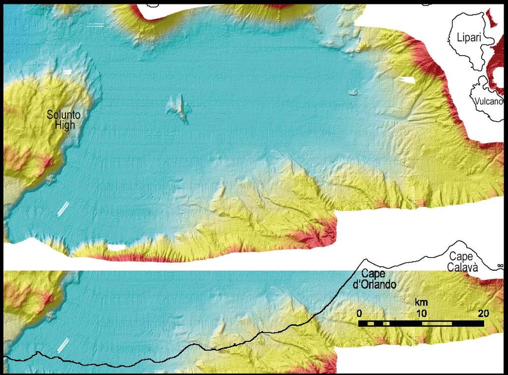
4 Leveed channels and mass-transport complexes Capo d Orlando basin Gioia Basin Basin plain confined by the Aeolian Islands Stromboli axial valley Aeolian Islands Sicily Data set Multibeam bathymetry and reflectivity Seismics High resolution subbottom profiles High resolution deep towed sidescan sonar
5 Leveed channels and mass-transport complexes Capo d Orlando basin Gioia Basin Basin plain confined by the Aeolian Islands Stromboli axial valley Aeolian Islands Sicily Aims of work Large scale depositional architecture of the margin Geometry of single depositional units Debrite-turbidite relationships

6 Notes by Presenter: Together with multibeam bathymetry data, also a network of seismic profiles are available, blue are depicted the old 30 KJ sparker lines acquired in the 70s by the institute for marine geology of bologna, in black the single-channel lines acquired together with the bathymetry, in red the more recent CHIRP profiles acquired during a pre-survey GEOSTAR deployment in The seimic data made possible to map two distinct events one the so called Nicotera slump an a frontally confined slide, defined as Villafranca.

7 Notes by Presenter: Together with multibeam bathymetry data, also a network of seismic profiles are available, blue are depicted the old 30 KJ sparker lines acquired in the 70s by the institute for marine geology of bologna, in black the single-channel lines acquired together with the bathymetry, in red the more recent CHIRP profiles acquired during a pre-survey GEOSTAR deployment in The seimic data made possible to map two distinct events one the so called Nicotera slump an a frontally confined slide, defined as Villafranca.

8 Notes by Presenter: Together with multibeam bathymetry data, also a network of seismic profiles are available, blue are depicted the old 30 KJ sparker lines acquired in the 70s by the institute for marine geology of bologna, in black the single-channel lines acquired together with the bathymetry, in red the more recent CHIRP profiles acquired during a pre-survey GEOSTAR deployment in The seimic data made possible to map two distinct events one the so called Nicotera slump an a frontally confined slide, defined as Villafranca.
9 Eastern Basin Repeated and on-going failures; Slope channels upslope from main failure Slope channel Levee wedge failure Western basin Turbidite leveed channel and lobe Leveed channel Slab slide Debris flow lobe Distributary channels Transpressional margin Of main landslide SE

10 Notes by Presenter: Together with multibeam bathymetry data, also a network of seismic profiles are available, blue are depicted the old 30 KJ sparker lines acquired in the 70s by the institute for marine geology of bologna, in black the single-channel lines acquired together with the bathymetry, in red the more recent CHIRP profiles acquired during a pre-survey GEOSTAR deployment in The seimic data made possible to map two distinct events one the so called Nicotera slump an a frontally confined slide, defined as Villafranca.

11 Notes by Presenter: Together with multibeam bathymetry data, also a network of seismic profiles are available, blue are depicted the old 30 KJ sparker lines acquired in the 70s by the institute for marine geology of bologna, in black the single-channel lines acquired together with the bathymetry, in red the more recent CHIRP profiles acquired during a pre-survey GEOSTAR deployment in The seimic data made possible to map two distint events one the so called Nicotera slump an a frontally confined slide, defined as Villafranca.
12 Villafranca channel mouth The relief at the eastern transpressional margin of the main landslide is onlapped by turbidites and debrites. Debrite 1 1 km 50 m

13 Sheet turbidites Debrite 1 Sheet turbidites Debrite Progressive onlap Villafranca channel mouth Debrite 1 channel Debrite 1 has an erosional basal surface that cut underlying turbidites. As a consequence, a package of turbidites with a thickness of 12 m is sandwiched between debrites and onlaps against the main landlside bolcks. The relief at the eastern transpressional margin of the main landslide is onlapped by turbidites and debrites. Debrite 1 Sheet turbidites Top of main landslide 1 km 50 m 1 km 50 m
14 Further downslope Debrite 1 has a conformable base. It is present to the east of the main depositional relief created by the distributary channels. Debrite 1 heals the topography of the lobes and seals turbidite deposits formed in the distributary channel area of the Villafranca fan. In turn, to the north, the debrite is eroded in places by successive channalized flows that, otherwise deposit sheet turbidites. Distributary channel Debrite 1 Distributary channel Distributary channel 50 m 1 km
15 Debris flow lobe Post-debris flow sediments Debris flow headwall scar Erosional steps Possible coarse grained material from slope channel Pressure ridges 500 m 25m The detachment of the debris flow lobe created a depression that is starting to be filled by confined coarse-grained deposits. Finer grained material can overspill the relief at the rear of the debris flow lobe and deposit above it 1 km 50 m Debrite 1 Debris flow lobe A further failure in the headwall of the main landslide resulted in the emplacment of a debris flow lobe with pressure ridge and high relief.
16

17 Leveed channels mass-transport complexes Capo d Orlando basin: seaward confined basin plain fans
18


19 Distributary channels Sediment waves Debrite lobes

20 Channels connected with the coastal areas are mainly fed by shelf derived turbidites. Channels not connected with the coastal area are mainly fed by landslides. As a consequence, turbidite and debrite fans are developed. A mixed facies occurs where levee failures is occurring adjecent to turbidite channels or where landslide can evolve into turbidites within the channels. Turbidite fan Mixed fans Debite fan
21
22 Sheet turbidite lobe Debrites 1200 m 50m Coherent block landslide Turbidite channel infill Unfailed levee wedge

23 Debrite Sheet turbidites 300 m 25m Top of blocky Mass-transport deposit Sheet turbidite lobe Debrites 1200 m 50m Coherent block landslide Turbidite channel infill Unfailed levee wedge

24 600 m 20 m Sheet turbidites Basal erosion Debrites 300 m 25 m Sheet turbidite lobe Debrites 1200 m 50m Coherent block landslide Turbidite channel infill Unfailed levee wedge
25 1000 m 1200 m Sheet turbidite lobe 1200 m 25 m Debrites MTD Blocks Unfailed levee wedge Turbidite channel infill


26 MTD blocks Turbidite channels MTD blocks 1200 m 25 m 1000 m 1200 m Sheet turbidite lobe 1200 m 25 m Debrites MTD Blocks Unfailed levee wedge Turbidite channel infill
27 1200 m 25 m Sheet turbidites Debrites MTD blocks 1000 m 1200 m Sheet turbidite lobe 1200 m 25 m Debrites MTD Blocks Unfailed levee wedge Turbidite channel infill
28 600 m 25 m Sheet Debrite turbidites 1000 m 1200 m Sheet turbidite lobe Debrites 1200 m 50 m Turbidite channel infill
29 Summary and conclusions: Relatively large-scale mass-transport deposits create seafloor topography In the evacuation area negative relief is infilled by coarse-grained deposits fed by slope channels. Debris flow lobe Post-debris flow sediments Debris flow headwall scar Erosional steps Possible coarse grained material from slope channel Pressure ridges 500 m 25m The detachment of the debris flow lobe created a depression that is starting to be filled by confined coarse-grained deposits. Finer grained material can overspill the relief at the rear of the debris flow lobe and deposit above it
30 Relatively large-scale mass-transport deposits create seafloor topography In the distal area the positive relief is onlapped by packages of turbidites and by debrites. As a result, sandy lobe deposits with thickness up to 30 m and with 3 km of lateral extent are sandwiched between debrite deposits. Sheet turbidites Debrite 1 Sheet turbidites Debrite Progressive onlap Sheet turbidites Top of main landslide 50 m Debrite 1 channel 1 km
31 Debrite lobes are characterized by a variety of shape 300 m 25 m Narrow channelized portion with steep margins deeply ploughing into the underlying sediments and lateral conformable wings. 600 m 20 m Sheet turbidites Basal erosion Debrites Gently dipping basal erosional surface without lateral conformable wings 600 m 25 m Sheet Debrite turbidites Gently dipping basal erosional surface and widespread lateral conformable wings
32 When conformable, debrites can seal turbidite lobe deposits due to the preexisting topography Distributary channel Debrite 1 Distributary channel Distributary channel 50 m 1 km A large variety of relationships between sand-prone turbidite units and clay-rich sealing debrites is thus to be expected.


33 General points: In tectonically active areas mass-transport processes and turbidity currents can create favourable conditions for the development of stratigraphic traps, with lobe turbidites that are sealed by thick debrite bodies. However, the large variety of geometry of the resultant depositional bodies can make reservoir characterization difficult. High resolution studies of modern examples can greatly help in deriving models. The concomitant growth of turbidites- mass transport deposits- and mixed fans demonstrate that models that predict changes in submarine fan facies on the base of sea-level cycles hardly apply to systems developed along tectonically active a margins.
Submarine canyons and channels of the Tyrrhenian Sea: from geological observations to oceanographic, biological and hazards studies
 SUBMARNE CANYON DYNAMCS - Sorrento, taly, 15-18 April 2015 Submarine canyons and channels of the Tyrrhenian Sea: from geological observations to oceanographic, biological and hazards studies Fabiano Gamberi
Prof Bryan T CRONIN Principal Geologist 2 Tullow Ghana Ltd
 Entrenched slope channel complex systems: Reservoir opportunities through understanding architectural element distribution and application to West Africa E&P Prof Bryan T CRONIN Principal Geologist 2 Tullow
The Ocean Floor Earth Science, 13e Chapter 13
 The Ocean Floor Earth Science, 13e Chapter 13 Stanley C. Hatfield Southwestern Illinois College The vast world ocean Earth is often referred to as the blue planet Seventy-one percent of Earth s surface
Map shows 3 main features of ocean floor
 Map shows 3 main features of ocean floor 2017 Pearson Education, Inc. Chapter 3 Marine Provinces 2017 Pearson Education, Inc. 1 Chapter 3 Overview The study of bathymetry determines ocean depths and ocean
Seismic Expressions of Submarine Channel - Levee Systems and Their Architectural Elements
 Seismic Expressions of Submarine Channel - Levee Systems and Their Architectural Elements Summary D.V. Ramana, Santanu De* and Kalyanbrata Datta KDMIPE, ONGC, Dehradun E-mail- devvenram@rediffmail.com
Lecture Outlines PowerPoint. Chapter 13 Earth Science 11e Tarbuck/Lutgens
 Lecture Outlines PowerPoint Chapter 13 Earth Science 11e Tarbuck/Lutgens 2006 Pearson Prentice Hall This work is protected by United States copyright laws and is provided solely for the use of instructors
Outcrops from Every Continent and 20 Countries in 140 Contributions. Tor H. Nilsen, Roger D. Shew, Gary S. Steffens, and Joseph R.J. Studlick.
 Paper VIII Tor H. Nilsen, Roger D. Shew, Gary S. Steffens, and Joseph R.J. Studlick Editors Outcrops from Every Continent and 20 Countries in 140 Contributions http://bookstore.aapg.org Length ~ 23 m (75.5
Lecture Marine Provinces
 Lecture Marine Provinces Measuring bathymetry Ocean depths and topography of ocean floor Sounding Rope/wire with heavy weight Known as lead lining Echo sounding Reflection of sound signals 1925 German
The Ocean Floor Chapter 14. Essentials of Geology, 8e. Stan Hatfield and Ken Pinzke Southwestern Illinois College
 The Ocean Floor Chapter 14 Essentials of Geology, 8e Stan Hatfield and Ken Pinzke Southwestern Illinois College The vast world ocean Earth is often referred to as the water planet 71% of Earth s surface
Deep Water Systems and Sequence Stratigraphy. By: Matt Kyrias, Chris Majerczyk, Nick Whitcomb, Wesley Vermillion
 Deep Water Systems and Sequence Stratigraphy By: Matt Kyrias, Chris Majerczyk, Nick Whitcomb, Wesley Vermillion Contents Gravity Flow Depositional Elements Defined References NOTE: Source uses seismic
Foundations of Earth Science, 6e Lutgens, Tarbuck, & Tasa
 Foundations of Earth Science, 6e Lutgens, Tarbuck, & Tasa Oceans: The Last Frontier Foundations, 6e - Chapter 9 Stan Hatfield Southwestern Illinois College The vast world ocean Earth is often referred
Chapter Overview. Bathymetry. Measuring Bathymetry. Measuring Bathymetry
 CHAPTER 3 Marine Provinces Chapter Overview The study of bathymetry determines ocean depths and ocean floor topography. Echo sounding and satellites are efficient bathymetric tools. Most ocean floor features
Bathymetry Measures the vertical distance from the ocean surface to mountains, valleys, plains, and other sea floor features
 1 2 3 4 5 6 7 8 9 10 11 CHAPTER 3 Marine Provinces Chapter Overview The study of bathymetry determines ocean depths and ocean floor topography. Echo sounding and satellites are efficient bathymetric tools.
MUHAMMAD S TAMANNAI, DOUGLAS WINSTONE, IAN DEIGHTON & PETER CONN, TGS Nopec Geological Products and Services, London, United Kingdom
 Geological and Geophysical Evaluation of Offshore Morondava Frontier Basin based on Satellite Gravity, Well and regional 2D Seismic Data Interpretation MUHAMMAD S TAMANNAI, DOUGLAS WINSTONE, IAN DEIGHTON
The Late Tertiary Deep-Water Siliciclastic System of the Levant Margin - An Emerging Play Offshore Israel*
 The Late Tertiary Deep-Water Siliciclastic System of the Levant Margin - An Emerging Play Offshore Israel* Michael A. Gardosh 1, Yehezkel Druckman 2 and Binyamin Buchbinder 2 Search and Discovery Article
Stratigraphic Architecture and Key Stratigraphic Surfaces Formed by Punctuated Flow Events - An Experiment on Fluviodeltaic Responses*
 Click to view movie-steady State Click to view movie-high Flow 1 Click to view movie- Low Flow 1 Click to view movie-high Flow Click to view movie-low Flow Note: If video clips do not function properly,
Controls on clastic systems in the Angoche basin, Mozambique: tectonics, contourites and petroleum systems
 P2-2-13 Controls on clastic systems in the Angoche basin, Mozambique: tectonics, contourites and petroleum systems Eva Hollebeek, Olivia Osicki, Duplo Kornpihl Schlumberger, London, UK Introduction Offshore
A Linked Shelf-Edge Delta and Slope-Channel Turbidite System: 3D Seismic Case Study from the Eastern Gulf of Mexico
 A Linked Shelf-Edge Delta and Slope-Channel Turbidite System: 3D Seismic Case Study from the Eastern Gulf of Mexico Posamentier, Henry W. Anadarko Canada Corporation 425 1 st Street SW Calgary, Alberta
2) re-positioning of the SSS data, 3) individuation of geomorphological features and morphometrical parameters correlated to instability phenomena.
 re-positioning of the SSS data, 3) individuation of geomorphological features and morphometrical parameters correlated to instability phenomena.") HIGH-RESOLUTION SIDE SCAN SONAR AND MULTIBEAM DATA PROCESSING AND MERGING TO STUDY SUBMARINE INSTABILITY PHENOMENA ON VOLCANIC ISLANDS (PONTINE, CAMPANIAN AND AEOLIAN ARCHIPELAGOS) A. BOSMAN Extended abstract:
HIGH-RESOLUTION SIDE SCAN SONAR AND MULTIBEAM DATA PROCESSING AND MERGING TO STUDY SUBMARINE INSTABILITY PHENOMENA ON VOLCANIC ISLANDS (PONTINE, CAMPANIAN AND AEOLIAN ARCHIPELAGOS) A. BOSMAN Extended abstract:
MARINE GEOLOGY & GEOGRAPHY
 MARINE GEOLOGY & GEOGRAPHY Bathymetry BATHYMETRY BATHYMETRY THE UNDERWATER EQUIVALENT TO TOPOGRAPHY THE STUDY OF WATER DEPTH A BATHYMETRIC MAP SHOWS FLOOR RELIEF OR TERRAIN AS CONTOUR LINES Bathymetry
Earth / Environmental Science. Ch. 14 THE OCEAN FLOOR
 Earth / Environmental Science Ch. 14 THE OCEAN FLOOR The Blue Planet Nearly 70% of the Earth s surface is covered by the global ocean It was not until the 1800s that the ocean became an important focus
UNIT 3 GEOLOGY VOCABULARY FLASHCARDS THESE KEY VOCABULARY WORDS AND PHRASES APPEAR ON THE UNIT 3 CBA
 UNIT 3 GEOLOGY VOCABULARY FLASHCARDS THESE KEY VOCABULARY WORDS AND PHRASES APPEAR ON THE UNIT 3 CBA A map that shows Earth s Topographic Map surface topography, which is Earth s shape and features Contour
Submarine Debris flow Project Proposal to Force August 2018/v1.02
 Submarine Debris flow Project Proposal to Force August 2018/v1.02 Summary The main objective of the Submarine Debris Flow study is to implement the concept of debris flow in the MassFlow3DÔ code as an
Chapter 9 Lecture Outline. Oceans: The Last Frontier
 Chapter 9 Lecture Outline Oceans: The Last Frontier The Vast World Ocean Earth is referred to as the blue planet 71% of Earth s surface is oceans and marginal seas Continents and islands comprise the remaining
Sequence Stratigraphy. Historical Perspective
 Sequence Stratigraphy Historical Perspective Sequence Stratigraphy Sequence Stratigraphy is the subdivision of sedimentary basin fills into genetic packages bounded by unconformities and their correlative
Deterministic, Process Based Modeling of the Deepwater Fill of the Peïra Cava Basin, SE France*
 Deterministic, Process Based Modeling of the Deepwater Fill of the Peïra Cava Basin, SE France* Romain Rouzairol 1, Riccardo Basani 2, Ernst W.M. Hansen 2, John A. Howell 3, and Tor E. Aas 4 Search and
L7/ Historical Perspec=ve, Deltas
 Colin Woodroffe (2002) Coasts: Form, Process and Evolu=on, Outline of Chapter 7: L7/1 L7/2 7.1. Historical Perspec=ve, 7.1.1. Deltas Herodotus (450, B.C.) delta = Shape of Nile River Delta = Δ Gilbert
The Marine Environment
 The Marine Environment SECTION 16.1 Shoreline Features In your textbook, read about erosional landforms, beaches, estuaries, longshore currents, and rip currents. For each statement below, write or. 1.
Abstract. Introduction. Regional Setting. GCSSEPM to be published December 2003
 Shelf Margin Deltas and Associated Deepwater Deposits: Implications on Reservoir Distribution and Hydrocarbon Entrapment, Block VI-1, Ulleung Basin, East Sea, South Korea Sneider, John S. Sneider Exploration,
The Marine Environment
 The Marine Environment SECTION 16.1 Shoreline Features In your textbook, read about erosional landforms, beaches, estuaries, longshore currents, and rip currents. For each statement below, write true or
ARTICLE IN PRESS. Quaternary Science Reviews
 Quaternary Science Reviews xxx (2008) 1 16 Contents lists available at ScienceDirect Quaternary Science Reviews journal homepage: www.elsevier.com/locate/quascirev Development and mass movement processes
Effects of Tides on Deltaic Deposition: Causes and Responses*
 Effects of Tides on Deltaic Deposition: Causes and Responses* Piret Plink-Bjorklund 1 Search and Discovery Article #50626 (2012)** Posted June 25, 2012 *Adapted from oral presentation at AAPG Annual Convention
Meandering Miocene Deep Sea Channel Systems Offshore Congo, West Africa
 Meandering Miocene Deep Sea Channel Systems Offshore Congo, West Africa S. Baer* (PGS), J. E. Comstock (PGS), K. Vrålstad (PGS), R. Borsato (PGS), M. Martin (PGS), J.P. Saba (SNPC), B. Débi-Obambé (SNPC)
Image: G. Parker. Presenters: Henry Chan, Kayla Ireland, Mara Morgenstern, Jessica Palmer, Megan Scott
 Image: G. Parker Presenters: Henry Chan, Kayla Ireland, Mara Morgenstern, Jessica Palmer, Megan Scott Is the Ross Formation a suitable analog for sand-rich turbidite plays in passive margin basins? Play:
Caspian Sea Geohazard Features
 Caspian Sea Geohazard Features Lev MERKLIN and Victoria PUTANS P.P.Shirshov Institute of oceanology, Russian Academy of Sciences 117997, Moscow, Nakhimovsky prospekt, 36 E-mail: lmerklin@ocean.ru HYDRO-2010
Introduction to sequence stratigraphy and its application to reservoir geology
 Introduction to sequence stratigraphy and its application to reservoir geology Massimo Zecchin Istituto Nazionale di Oceanografia e di Geofisica Sperimentale - OGS Historical development Definitions Systems
SUMMARY OF ACTIVITIES CARRIED OUT OFFSHORE SCIARA DEL FUOCO IN THE FRAMEWORK OF THE GNV PROJECT #15
 SUMMARY OF ACTIVITIES CARRIED OUT OFFSHORE SCIARA DEL FUOCO IN THE FRAMEWORK OF THE GNV PROJECT #15 Immediately after the tsunami event which occurred on December 30, researchers involved in the GNV Project
Erlangga Septama 1 and Samuel J. Bentley 1. Search and Discovery Article #50283 (2010) Posted August 10, 2010
 Posted August 10, 2010") Late Quaternary Deepwater Fan Depositional Cycles in the Gulf of Papua: Linking Sources, Dynamic Sedimentation Processes, and Depositional Architecture* Erlangga Septama 1 and Samuel J. Bentley 1 Search
Late Quaternary Deepwater Fan Depositional Cycles in the Gulf of Papua: Linking Sources, Dynamic Sedimentation Processes, and Depositional Architecture* Erlangga Septama 1 and Samuel J. Bentley 1 Search
DATA REPOSITORY MATERIAL: PALEOCHANNEL GROUP MAPPING DESCRIPTIONS
 Data Repository item 2695 DATA REPOSITORY MATERIAL: PALEOCHANNEL GROUP MAPPING DESCRIPTIONS Groups 1 (North Myrtle Beach) and 2 (Atlantic Beach) Channel Groups 1 (North Myrtle Beach) and 2 (Atlantic Beach)
Case Study of the Structural and Depositional-Evolution Interpretation from Seismic Data*
 Case Study of the Structural and Depositional-Evolution Interpretation from Seismic Data* Yun Ling 1, Xiangyu Guo 1, Jixiang Lin 1, and Desheng Sun 1 Search and Discovery Article #20143 (2012) Posted April
Structural Geology of the Mountains
 Structural Geology of the Mountains Clinton R. Tippett Shell Canada Limited, Calgary, Alberta clinton.tippett@shell.ca INTRODUCTION The Southern Rocky Mountains of Canada (Figure 1) are made up of several
Geophysics the use of geology, laboratory & field experiments, mathematics, and instruments to study: Earthquakes and Volcanoes seismometers,
 Geophysics the use of geology, laboratory & field experiments, mathematics, and instruments to study: Earthquakes and Volcanoes seismometers, tiltmeters, EDM, remote sensing, Energy: oil, gas, hydrothermal
Ministry of Oil and Minerals Petroleum Exploration & Production Authority BLOCK 85 (Al Uqlah North)
") Ministry of Oil and Minerals Petroleum Exploration & Production Authority BLOCK 85 (Al Uqlah North) The Al Uqlah North Block (85) occupies an area of 597 km 2 in the Sabatayn Basin in the province of Shabwah
Ministry of Oil and Minerals Petroleum Exploration & Production Authority BLOCK 85 (Al Uqlah North) The Al Uqlah North Block (85) occupies an area of 597 km 2 in the Sabatayn Basin in the province of Shabwah
14.2 Ocean Floor Features Mapping the Ocean Floor
 14.2 Ocean Floor Features Mapping the Ocean Floor The ocean floor regions are the continental margins, the ocean basin floor, and the mid-ocean ridge. 14.2 Ocean Floor Features Continental Margins A continental
Ministry of Oil and Minerals Petroleum Exploration & Production Authority BLOCK 6 (Iryam)
") Ministry of Oil and Minerals Petroleum Exploration & Production Authority BLOCK 6 (Iryam) The Iryam Block (6) occupies an area of 3,911 km 2 in the Sabatayn Basin in the province of Shabwah in central
Ministry of Oil and Minerals Petroleum Exploration & Production Authority BLOCK 6 (Iryam) The Iryam Block (6) occupies an area of 3,911 km 2 in the Sabatayn Basin in the province of Shabwah in central
Structural Styles and Geotectonic Elements in Northwestern Mississippi: Interpreted from Gravity, Magnetic, and Proprietary 2D Seismic Data
 Structural Styles and Geotectonic Elements in Northwestern Mississippi: Interpreted from Gravity, Magnetic, and Proprietary 2D Seismic Data Nick Loundagin 1 and Gary L. Kinsland 2 1 6573 W. Euclid Pl.,
MARINE GEOLOGY & GEOGRAPHY
 MARINE GEOLOGY MARINE GEOLOGY & GEOGRAPHY Marine Geology 4 LAYERS OF THE EARTH CRUST THICKNESS: VARIES BETWEEN OCEAN & CONTINENTS 5-40 KM STATE: SOLID ELEMENTS: SILICON, ALUMINUM, CALCIUM, SODIUM, POTASSIUM
Figure 1 Extensional and Transform Fault Interaction, Influence on the Upper Cretaceous Hydrocarbon System, Equatorial Margin, West Africa.
 Figure 1 Extensional and Transform Fault Interaction, Influence on the Upper Cretaceous Hydrocarbon System, Equatorial Margin, West Africa. Presented to the 10th PESGB/HGS Conference on Africa E + P September
Lecture 05: Ocean Basins. Hypsometric Curve. Consider Ocean Basins: What is the elevation of Chambana?
 Lecture 05: Ocean Basins 1 Hypsometric Curve What is the elevation of Chambana? Shows distribution of surface relative to sea level ~67% below sea level Mean ocean depth ~ -3.7 km (well below sea level)
Marine Science and Oceanography
 Marine Science and Oceanography Marine geology- study of the ocean floor Physical oceanography- study of waves, currents, and tides Marine biology study of nature and distribution of marine organisms Chemical
Earth s Continents and Seafloors. GEOL100 Physical Geology Ray Rector - Instructor
 Earth s Continents and Seafloors GEOL100 Physical Geology Ray Rector - Instructor OCEAN BASINS and CONTINENTAL PLATFORMS Key Concepts I. Earth s rocky surface covered by of two types of crust Dense, thin,
Oceanography, An Invitation to Marine Science 9e Tom Garrison. Ocean Basins Cengage Learning. All Rights Reserved.
 Oceanography, An Invitation to Marine Science 9e Tom Garrison 4 Ocean Basins Key Concepts Tectonic forces shape the seabed The ocean floor is divided into continental margins and deep ocean basins The
Application of Predictive Modeling to the Lower Cretaceous Sedimentary Sequences of the Central Scotian Basin
 Application of Predictive Modeling to the Lower Cretaceous Sedimentary Sequences of the Central Scotian Basin Christopher R. Sangster 1, Nicolas Hawie 2, Georgia Pe-Piper 1, Francky Saint-Ange 2, David
Surface Processes Focus on Mass Wasting (Chapter 10)
") Surface Processes Focus on Mass Wasting (Chapter 10) 1. What is the distinction between weathering, mass wasting, and erosion? 2. What is the controlling force in mass wasting? What force provides resistance?
Surface Processes Focus on Mass Wasting (Chapter 10) 1. What is the distinction between weathering, mass wasting, and erosion? 2. What is the controlling force in mass wasting? What force provides resistance?
Reading Material. See class website. Sediments, from Oceanography M.G. Gross, Prentice-Hall
 Reading Material See class website Sediments, from Oceanography M.G. Gross, Prentice-Hall Materials filling ocean basins Dissolved chemicals especially from rivers and mid-ocean ridges (volcanic eruptions)
Introduction to Acoustic Remote Sensing and Seafloor Mapping (AE4-E13) May 19, 2010
 May 19, 2010") Introduction to Acoustic Remote Sensing and Seafloor Mapping (AE4-E13) May 19, 2010 1 Delft Vermelding Institute onderdeel of Earth organisatie Observation and Space Systems Why Acoustic Remote Sensing?
Introduction to Acoustic Remote Sensing and Seafloor Mapping (AE4-E13) May 19, 2010 1 Delft Vermelding Institute onderdeel of Earth organisatie Observation and Space Systems Why Acoustic Remote Sensing?
Satyabrata Nayak*, Rabi Bastia, Raj kumar Yadav, Lokesh Ambati Petroleum Business (E&P), Reliance Industries Limited, India
, Reliance Industries Limited, India") P-332 Influence of Mass Transport Deposits over Paleo-Topography and Sediment Dispersal Pattern: A Case Stuydy Using Shallow Seismic Data, Offshore Krishna-Godavari Basin Satyabrata Nayak*, Rabi Bastia,
P-332 Influence of Mass Transport Deposits over Paleo-Topography and Sediment Dispersal Pattern: A Case Stuydy Using Shallow Seismic Data, Offshore Krishna-Godavari Basin Satyabrata Nayak*, Rabi Bastia,
Directed Reading. Section: The Water Planet. surface is called the a. Earth s ocean. b. Pacific Ocean. c. salt-water ocean. d. global ocean.
 Skills Worksheet Directed Reading Section: The Water Planet 1. The body of salt water covering nearly three-quarters of the Earth s surface is called the a. Earth s ocean. b. Pacific Ocean. c. salt-water
Seafloor Morphology. Techniques of Investigation. Bathymetry and Sediment Studies
 Seafloor Morphology I f we select a grid for the surface of the earth (i.e. 5 km 2 ) and assign it an average elevation in relation to sea level, we can construct a graph of elevation versus area of the
Ocean Basins, Bathymetry and Sea Levels
 Ocean Basins, Bathymetry and Sea Levels Chapter 4 Please read chapter 5: sediments for next class and start chapter 6 on seawater for Thursday Basic concepts in Chapter 4 Bathymetry the measurement of
Seismic interpretation. Principles of seismic stratigraphic interpretation
 Seismic interpretation Principles of seismic stratigraphic interpretation Seismic interpretation Seismic stratigraphy is a technical for interpreting stratigraphic information from seismic data. The resolution
Bikashkali Jana*, Sudhir Mathur, Sudipto Datta
 10 th Biennial International Conference & Exposition P 354 Facies characterization of a low permeability Cretaceous clastic reservoir to understand reservoir spatial distribution in the Nagayalanka Field,
Divergent Boundaries: Origin and Evolution of the Ocean Floor
 1 2 3 4 5 6 7 8 9 10 11 12 Divergent Boundaries: Origin and Evolution of the Ocean Floor Earth, 12 th Edition, Chapter 13 Chapter 13 Divergent Boundaries From 1872 to 1876, the HMS Challenger expedition
Search and Discovery Article #50197 (2009) Posted August 28, Abstract
 Posted August 28, Abstract") Turbidite Sedimentation along Topographically Complex Slopes in Convergent Margin: Example of the Makran Accretionary Prism (Gulf of Oman, NW Indian Ocean)* Julien Bourget 1, Sébastien Zaragosi 1, Nadine
Turbidite Sedimentation along Topographically Complex Slopes in Convergent Margin: Example of the Makran Accretionary Prism (Gulf of Oman, NW Indian Ocean)* Julien Bourget 1, Sébastien Zaragosi 1, Nadine
Continental Margin Geology of Korea : Review and constraints on the opening of the East Sea (Japan Sea)
") Continental Margin Geology of Korea : Review and constraints on the opening of the East Sea (Japan Sea) Han-Joon Kim Marine Satellite & Observation Tech. Korea Ocean Research and Development Institute
Continental Margin Geology of Korea : Review and constraints on the opening of the East Sea (Japan Sea) Han-Joon Kim Marine Satellite & Observation Tech. Korea Ocean Research and Development Institute
Submarine spreading: Dynamics and development.
 Submarine spreading: Dynamics and development. Aaron Micallef *, Douglas G. Masson, Christian Berndt and Dorrik A.V. Stow National Oceanography Centre, European Way, Southampton, SO14 3ZH, UK. Telephone:
Chapter 5. The Sedimentary Archives
 Chapter 5 The Sedimentary Archives Factors affecting Sedimentary Characteristics 1. Tectonic setting 2. Physical, chemical, and biological processes in the depositional environment 3. Method of sediment
Use of Cellular Automata Flow Model in the Hybrid Geostatistical Models: A Proposal
 Use of Cellular Automata Flow Model in the Hybrid Geostatistical Models: A Proposal Siyao Xu and Tapan Mukerji Graduate Program in Earth, Energy and Environmental Sciences Stanford University Abstract
ARE YOU READY TO THINK? Look at the first slide THINK PAIR SHARE!
 ARE YOU READY TO THINK? Look at the first slide THINK PAIR SHARE! WHAT PROMINENT FEATURE CAN YOU IDENTIFY IN THIS PICTURE? What do you think the different colors represent? Who might find such a picture
Landscape. Review Note Cards
 Landscape Review Note Cards Last Ice Age Pleistocene Epoch that occurred about 22,000 Years ago Glacier A large, long lasting mass of ice which forms on land and moves downhill because of gravity. Continental
Gravity-induced deep-water carbonate deposits: Potential new plays in the Eocene of the Sirte Basin, Libya
 Gravity-induced deep-water carbonate deposits: Potential new plays in the Eocene of the Sirte Basin, Libya Uwe P. Baaske 1, Paul Tricker 1, Jimmy Van Itterbeeck 2, Helena Griffiths 2 and Jim Pickens 1
Parameter Estimation and Sensitivity Analysis in Clastic Sedimentation Modeling
 Parameter Estimation and Sensitivity Analysis in Clastic Sedimentation Modeling A. Acevedo 1, A. Khramtsov 2, H. A. Madhoo 3, L. Noomee 4, and D. Tetzlaff 5 1 Schlumberger Information Solutions,Gatwick,
depression above scarp scarp
 1 LAB 1: FIELD TRIP TO McKINLEYVILLE AND MOUTH OF THE MAD RIVER OBJECTIVES: a. to look at geomorphic and geologic evidence for large scale thrust-faulting of young sediments in the Humboldt Bay region
Neotectonic Implications between Kaotai and Peinanshan
 Neotectonic Implications between Kaotai and Peinanshan Abstract Longitudinal Valley was the suture zone between the Philippine Sea plate and the Eurasia plate. Peinanshan was the southest segment of the
Downstream evolution of the Stromboli slope valley (southeastern Tyrrhenian Sea)
") Marine Geology 243 (2007) 180 199 www.elsevier.com/locate/margeo Downstream evolution of the Stromboli slope valley (southeastern Tyrrhenian Sea) Fabiano Gamberi, Michael Marani Istituto di Scienze Marine,
Marine Geology 243 (2007) 180 199 www.elsevier.com/locate/margeo Downstream evolution of the Stromboli slope valley (southeastern Tyrrhenian Sea) Fabiano Gamberi, Michael Marani Istituto di Scienze Marine,
Soft-sediment deformation in deltaic sediments
 Soft-sediment deformation in deltaic sediments Alie: Background about soft sediment deformation Mary: Sandbox modeling Nick: What we ll see in Ireland Becca: Modern analogs Soft-Sediment Deformation Deformation
Seismic Reflection Imaging across the Johnson Ranch, Valley County, Idaho
 Seismic Reflection Imaging across the Johnson Ranch, Valley County, Idaho Report Prepared for the Skyline Corporation Lee M. Liberty Center for Geophysical Investigation of the Shallow Subsurface (CGISS)
Lecture 26: Marine Geology Read: Chapter 21 Homework due December 3
 Learning Objectives (LO) Lecture 26: Marine Geology Read: Chapter 21 Homework due December 3 What we ll learn today:! 1. Describe the world s five oceans! 2. Understand patterns of ocean circulation! 3.
Infilled Kettle Hole, Easton, Aroostook County, Maine
 Maine Geologic Facts and Localities June, 1997, Maine 46 41 26.40 N, 67 48 35.74 W Text by Tom Weddle, Department of Agriculture, Conservation & Forestry 1 Introduction As the last continental glacier
Bell Ringer. Are soil and dirt the same material? In your explanation be sure to talk about plants.
 Bell Ringer Are soil and dirt the same material? In your explanation be sure to talk about plants. 5.3 Mass Movements Triggers of Mass Movements The transfer of rock and soil downslope due to gravity is
OTC Copyright 2001, Offshore Technology Conference
 OTC 12960 East Breaks Slump, Northwest Gulf of Mexico Peter Trabant/ Consultant, Philip Watts/Applied Fluids Engineering, Inc., Frederick L. Lettieri/Mariner Energy, Inc., George A. Jamieson/WesternGeco
Sediment and sedimentary rocks Sediment
 Sediment and sedimentary rocks Sediment From sediments to sedimentary rocks (transportation, deposition, preservation and lithification) Types of sedimentary rocks (clastic, chemical and organic) Sedimentary
Fluid-Mud Deposits of the Lower Jurassic Tilje Formation, Offshore Mid-Norway By Aitor A. Ichaso and Robert W. Dalrymple 1
 Fluid-Mud Deposits of the Lower Jurassic Tilje Formation, Offshore Mid-Norway By Aitor A. Ichaso and Robert W. Dalrymple 1 Search and Discovery Article #50107 (2008) Posted August 10, 2008 *Adapted from
Downloaded 08/28/18 to Redistribution subject to SEG license or copyright; see Terms of Use at
 Characterization of mass transport deposit using seismic attributes: Spraberry formation, Midland Basin, West Texas Paritosh Bhatnagar*, Matthew Scipione, Sumit Verma, University of Texas Permian Basin;
Cold Water Coral WHY?
 The Cold Water Coral Research by bathymetry, acoustic geophysical and methane data, Santa Maria di Leuca, Northern Ionian Sea Apulian continental slop. Speaker: Kuan-Ting Lin March 15 th 2012 WHY? Where
Origin and Evolution of the Ocean Floor
 Chapter 13 Lecture Earth: An Introduction to Physical Geology Twelfth Edition Origin and Evolution of the Ocean Floor Tarbuck and Lutgens Chapter 13 Divergent Boundaries An Emerging Picture of the Ocean
Evan K. Franseen, Dustin Stolz, Robert H. Goldstein, KICC, Department of Geology, University of Kansas
 Reservoir Character of the Avalon Shale (Bone Spring Formation) of the Delaware Basin, West Texas and Southeast New Mexico: Effect of Carbonate-rich Sediment Gravity Flows Evan K. Franseen, Dustin Stolz,
Vail et al., 1977b. AAPG 1977 reprinted with permission of the AAPG whose permission is required for further use.
 Well 5 Well 4 Well 3 Well 2 Well 1 Vail et al., 1977b AAPG 1977 reprinted with permission of the AAPG whose permission is required for further use. Well 5 Well 4 Well 3 Well 2 Well 1 Vail et al., 1977b
Ocean Floor. Continental Margins. Divided into 3 major regions. Continental Margins. Ocean Basins. Mid-Ocean Ridges. Include:
 Ocean Floor Divided into 3 major regions Continental Margins Ocean Basins Mid-Ocean Ridges Continental Margins Include: Continental Shelves Continental Slopes Continental Rise 1 Continental Shelves Part
Continental Landscapes
 Continental Landscapes Landscape influenced by tectonics, climate & differential weathering Most landforms developed within the last 2 million years System moves toward an equilibrium Continental Landscapes
Origin and Evolution of the Ocean Floor
 Origin and Evolution of the Ocean Floor Outline Mapping the Ocean Floor Continental Margins Origin of Oceanic Lithosphere Structure of Ocean Crust Mapping the ocean floor Depth originally measured by lowering
ES120 Sedimentology/Stratigraphy
 Midterm Exam 5/05/08 NAME: 1. List or describe 3 physical processes that contribute to the weathering of rocks (3pts). exfoliation frost wedging many others. roots, thermal expansion/contraction also credit
Stratigraphic and Geoacoustic Characterization of the Outer New Jersey Shelf
 Stratigraphic and Geoacoustic Characterization of the Outer New Jersey Shelf John A. Goff Institute for Geophysics, Jackson School of Geoscience University of Texas at Austin JJ Pickle Research Campus,
Unit 6: The Sea Floor
 Unit 6: The Sea Floor Turn to Page 62 in Introduction to the World s Oceans Study the bathymetric chart What features do you see? How do the Atlantic and Pacific Oceans differ? What do you think accounts
Seismic stratigraphy, some examples from Indian Ocean, interpretation of reflection data in interactive mode
 Seismic stratigraphy, some examples from Indian Ocean, interpretation of reflection data in interactive mode K. S. Krishna National Institute of Oceanography, Dona Paula, Goa-403 004. krishna@nio.org Seismic
24. Ocean Basins p
 24. Ocean Basins p. 350-372 Background The majority of the planet is covered by ocean- about %. So the majority of the Earth s crust is. This crust is hidden from view beneath the water so it is not as
FLUVIAL LANDFORMS. Floodplains
 FLUVIAL LANDFORMS Floodplains fairly flat & continuous surface occupying much of a valley bottom normally underlain by unconsolidated sediments subject to periodic flooding (usually once every year or
APPENDIX C GEOLOGICAL CHANCE OF SUCCESS RYDER SCOTT COMPANY PETROLEUM CONSULTANTS
 APPENDIX C GEOLOGICAL CHANCE OF SUCCESS Page 2 The Geological Chance of Success is intended to evaluate the probability that a functioning petroleum system is in place for each prospective reservoir. The
THE QUATERNARY GEOLOGY OF NEWARK BAY AND KILL VAN KULL CHANNEL, NEW YORK AND NEW JERSEY. and
 THE QUATERNARY GEOLOGY OF NEWARK BAY AND KILL VAN KULL CHANNEL, NEW YORK AND NEW JERSEY Stephanie Beda, W. Bruce Ward, William Murphy, Robert Fleming, Gary Fleming, Beckett Boyd Earthworks LLC 27 Glen
Plate Tectonics 3. Where Does All the Extra Crust Go?
 Plate Tectonics 3 Where Does All the Extra Crust Go? Unless otherwise noted the artwork and photographs in this slide show are original and by Burt Carter. Permission is granted to use them for non-commercial,