Sequence Stratigraphy. Historical Perspective
|
|
|
- Tobias Collins
- 6 years ago
- Views:
Transcription
1 Sequence Stratigraphy Historical Perspective
2 Sequence Stratigraphy Sequence Stratigraphy is the subdivision of sedimentary basin fills into genetic packages bounded by unconformities and their correlative conformities. It is used to provide a chronostratigraphic framework for the correlation and mapping of sedimentary facies and for stratigraphic prediction.

3 Lithostratigraphy Is the correlation of similar lithologist, which are commonly diachronous and have no time- significant. The difference between sequence stratigraphy, which has geologic time significance, and Lithostratigraphy which correlates rocks of similar type. A lithostratigraphic correlation would correlate conglomerate units 1 and 2, sandstone units 3, 4 and 5, and mudstone units 6, 7 and 8. A sequence stratigraphic correlation would correlate time lines A-A, B-B and C-C.
4 Evolution of Sequen. strat. Relatively new evolving in the 1970 from seismic stratigraphy. But the roots go back to the controversies over the origin of cyclic sedimentation and eustatic versus tectonics controls of sea-level. Maiilet, 1748 interpretation of the development of sedimentary units by marine erosion.
5
6 Concepts and Principles of Sequence Stratigraphy The stratal patterns in the sedimentary record are the results of: Tectonics Eustasy Climate Tectonic and eustasy control the amount of space available for sediment to accumulate (accommodation), and tectonics, eustasy, and climate interact to control sediment supply and how much of the accommodation is filled.
7 Basin forming processes Tectonism represents the primary control on the creation and destruction of accommodation. Without tectonic subsidence there is no sedimentary basins. It also influences the rate of sediment supply to basins.
8 Tectonic subsidence Two principle mechanisms: Extension Flexural loading of the lithosphere

9 Tectonic subsidence history in rift, foreland and strike-slip basins.

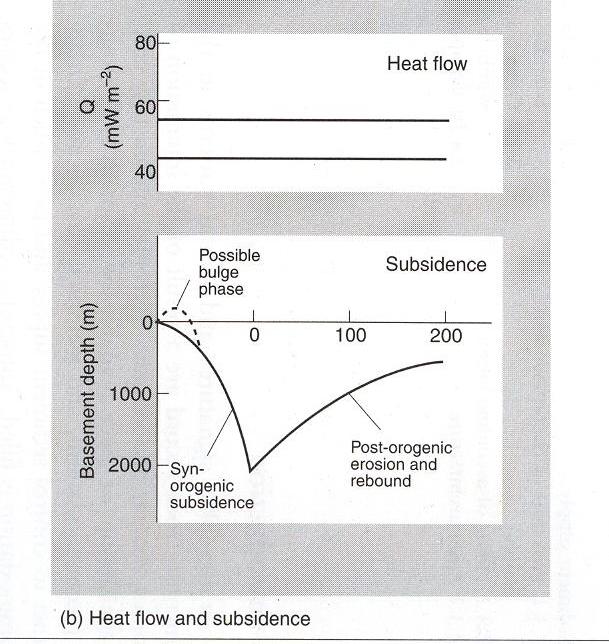
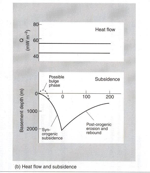
10 They form in a variety of tectonic settings. Very rapid subsidence Caused by isostatic adjustment to Lithosphere stretching, followed By a gradual ( million yr) and decreasing thermal subsidence Phase as the asthenosphere cools.

11 Foreland basins develop in response to loading of the lithosphere below thrust belts. The lithospheres bends in response to loading as the thrust sheets are emplaced, and creates a depression that is accentuated toward the loads.
12
13
 are Extremely")
14 Strike-slip basins do not have a Characteristic subsidence pattern, although in general, rates of Subsidence (and uplift) are Extremely rapid.
15 Basin-margin concepts Many of the concepts and principles of sequence stratigraphy are base on the observation from seismic data that prograding basin-margin systems often have a consistent depositional geometry.
16 Topset is a term used to describe the proximal portion of the basin-margin profile characterized by low gradients (<0.1 ). Topsets effectively appear flat on seismic data and generally contain alluvial, deltaic and shallow-marine depositional systems. The shoreline can be located at any point within the topset.
17 Clinoform is used to describe the more steeply dipping portion of the basin-margin profile (commonly >1 ) ) developed basinward of the topset. Clinoforms generally contain deeper water depositional characteristic of slope. The slope of the clinoform usually can be resolved on seismic data.
18 Bottomset is a term sometimes used to describe the portion of the basin-margin profile at the base of the clinoform characterized by low gradients and containing deep-water depositional systems.
19 The main break in slope in the depositional profile occurs between topset and clinoform and is called the offlap break. Previously termed the shelf-edge.
20 The topset-clinoform profile results from the interplay between sediment supply and wave, storm and tidal energy in the basin.sediments enters through rivers systems and is distribute across the topset area by wave- and/or current-related processes. However the transport is only effective at relatively shallow depths of a few meters, and to move sediment into deeper water a slope must develop by gravity.
21 The clinoforms build to the angle needed to transport sediment at the required rate. Slope angle is strongly influenced by sediment size. Coarse-grained sediment, with a higher angle of rest, will build up steeper slopes than fine-grained sediment. Carbonate systems can build steeper depositional slopes of

22 Basin margin type Well developed Depositional clinoforms Depositional angle are Less than 1 and seismic clinoforms are shingled.

23 Spatial distribution of sediments accommodation is controlled by tectonics. Sediment accommodation may be relatively higher in proximal areas compare to the basin center. The rate of subsidence is greater on the hanging-wall side of the growth fault, resulting in expanded sedimentary succession.
Depositional Sequences Sequences
 Depositional Sequences Transgressive and Regressive packages can be bound by unconformities Because sediment can only be preserved during net aggradation and progradation All other times there is either
Accommodation. Tectonics (local to regional) Subsidence Uplift
 Subsidence Uplift") Accommodation Accommodation varies over time; it is the distance between a reference horizon and the sea surface (i.e. relative sea level). The space to be filled in with sediments or water What are the
Accommodation Accommodation varies over time; it is the distance between a reference horizon and the sea surface (i.e. relative sea level). The space to be filled in with sediments or water What are the
Sedimentary Basins. Gerhard Einsele. Springer-Verlag Berlin Heidelberg New York London Paris Tokyo Hong Kong Barcelona Budapest
 Gerhard Einsele Sedimentary Basins Evolution, Facies, and Sediment Budget With 269 Figures Springer-Verlag Berlin Heidelberg New York London Paris Tokyo Hong Kong Barcelona Budapest Contents Part I Types
Seismic stratigraphy, some examples from Indian Ocean, interpretation of reflection data in interactive mode
 Seismic stratigraphy, some examples from Indian Ocean, interpretation of reflection data in interactive mode K. S. Krishna National Institute of Oceanography, Dona Paula, Goa-403 004. krishna@nio.org Seismic
Understanding Earth Fifth Edition
 Understanding Earth Fifth Edition Grotzinger Jordan Press Siever Chapter 5: SEDIMENTATION: Rocks Formed by Surface Processes Lecturer: H Mohammadzadeh Assistant professors, Department of Geology, FUM Copyright
Abstract. Introduction. Regional Setting. GCSSEPM to be published December 2003
 Shelf Margin Deltas and Associated Deepwater Deposits: Implications on Reservoir Distribution and Hydrocarbon Entrapment, Block VI-1, Ulleung Basin, East Sea, South Korea Sneider, John S. Sneider Exploration,
Sequence Stratigraphy as a tool for water resources management in alluvial coastal aquifers: application to the Llobregat delta (Barcelona, Spain)
") Sequence Stratigraphy as a tool for water resources management in alluvial coastal aquifers: application to the Llobregat delta (Barcelona, Spain) Desiré Gàmez Torrent December 2007 CHAPTER 1: Introduction
Sequence Stratigraphy as a tool for water resources management in alluvial coastal aquifers: application to the Llobregat delta (Barcelona, Spain) Desiré Gàmez Torrent December 2007 CHAPTER 1: Introduction
EDIMENTARY BASINS. What is a Sedimentary Basin? by Prof. Dr. Abbas Mansour
 EDIMENTARY BASINS What is a Sedimentary Basin? by Prof. Dr. Abbas Mansour WHAT IS A SEDIMENTARY BASIN? A low area on the Earth s surface relative to surroundings e.g. deep ocean basin (5-10 km deep) e.g.
4.1 Sediment accommodation space principles and controls
 58 The sedimentary record of sea-level change 4. Sediment accommodation space principles and controls Sequence stratigraphy emphasizes the importance of the space that is made available within a basin
 Sedimentary Basin Analysis http://eqsun.geo.arizona.edu/geo5xx/geos517/ Sedimentary basins can be classified based on the type of plate motions (divergent, convergent), type of the lithosphere, distance
Effects of Tides on Deltaic Deposition: Causes and Responses*
 Effects of Tides on Deltaic Deposition: Causes and Responses* Piret Plink-Bjorklund 1 Search and Discovery Article #50626 (2012)** Posted June 25, 2012 *Adapted from oral presentation at AAPG Annual Convention
Introduction to sequence stratigraphy and its application to reservoir geology
 Introduction to sequence stratigraphy and its application to reservoir geology Massimo Zecchin Istituto Nazionale di Oceanografia e di Geofisica Sperimentale - OGS Historical development Definitions Systems
Neogene Uplift of The Barents Sea
 Neogene Uplift of The Barents Sea W. Fjeldskaar A. Amantov Tectonor/UiS, Stavanger, Norway FORCE seminar April 4, 2013 The project (2010-2012) Funding companies Flat Objective The objective of the work
Accommodation- vs. supply-dominated systems for sediment partitioning to deep water. Supplementary documents
 GSA Data Repository 2019145 1 2 Accommodation- vs. supply-dominated systems for sediment partitioning to deep water Supplementary documents 3 4 5 6 Jinyu Zhang 1, Wonsuck Kim 1, Cornel Olariu 1,2, Ronald
NAME: GEL 109 Final Winter 2010
 GEL 109 Final Winter 2010 1. The following stratigraphic sections represents a single event followed by the slow accumulation of background sedimentation of shale. Describe the flows that produced the
Plate Tectonics. entirely rock both and rock
 Plate Tectonics I. Tectonics A. Tectonic Forces are forces generated from within Earth causing rock to become. B. 1. The study of the origin and arrangement of Earth surface including mountain belts, continents,
NAME HOMEWORK ASSIGNMENT #3 MATERIAL COVERS CHAPTERS 8, 9, 10, 11
 NAME HOMEWORK ASSIGNMENT #3 MATERIAL OVERS HAPTERS 8, 9, 10, 11 Assignment is due the beginning of the class period on November 23, 2004. Answers for each chapter will be discussed in class, as Exam #3
Answers: Internal Processes and Structures (Isostasy)
") Answers: Internal Processes and Structures (Isostasy) 1. Analyse the adjustment of the crust to changes in loads associated with volcanism, mountain building, erosion, and glaciation by using the concept
Answers: Internal Processes and Structures (Isostasy) 1. Analyse the adjustment of the crust to changes in loads associated with volcanism, mountain building, erosion, and glaciation by using the concept
Sequence Stratigraphy: An Applied Workshop
 Sequence Stratigraphy: An Applied Workshop Instructor: Prof. Octavian Catuneanu Level: Intermediate Duration: 5 days Course Description and Objectives This workshop presents the concepts and practical
Geologic Structures. Changes in the shape and/or orientation of rocks in response to applied stress
 Geologic Structures Changes in the shape and/or orientation of rocks in response to applied stress Figure 15.19 Can be as big as a breadbox Or much bigger than a breadbox Three basic types Fractures >>>
Seismic interpretation. Principles of seismic stratigraphic interpretation
 Seismic interpretation Principles of seismic stratigraphic interpretation Seismic interpretation Seismic stratigraphy is a technical for interpreting stratigraphic information from seismic data. The resolution
SEQUENCE STRATIGRAPHY
 SEQUENCE STRATIGRAPHY Course of Stratigraphy G301 Second semester (February-June2014) Department of Geology College of Science/University of Basrah Instructor:Dr. Nawrast S. Abd Alwahab Lecture 4 & 5 1
Beckenanalyse 2. Genetische stratigraphische Konzepte
 Beckenanalyse 2. Genetische stratigraphische Konzepte Einsele 2000 CYCLIC BEDDING Einsele 2000 1 Sequenzstratigraphie Das Konzept der Sequenzstratigraphie beruht auf dem Zusammenspiel von Sedimentzufuhr
GY 112L Earth History
 GY 112L Earth History Lab 2 Vertical Successions and Sequences of Events GY 112L Instructors: Douglas Haywick, James Connors, Mary Anne Connors Department of Earth Sciences, University of South Alabama
Carboniferous Stoddart Group: An integrated approach
 Carboniferous Stoddart Group: An integrated approach Abu Yousuf*, Department of Geoscience, University of Calgary, Calgary, Alberta yousufabu@hotmail.com and Charles M. Henderson, Department of Geoscience,
Basin Analysis. Stra-graphy
 Basin Analysis Stra-graphy Basin Analysis Basin analysis integrates program sedimentological, stra-graphic, and tectonic principals to develop a full understanding of the rocks that fill sedimentary basins.
Geology of Neoproterozoic to Cambrian Adelaide Geosyncline and Cambrian Delamerian Orogen
 Geology of Neoproterozoic to Cambrian Adelaide Geosyncline and Cambrian Delamerian Orogen W. V. Preiss Geological Survey Branch, PIRSA Link line traverses Flinders Ranges to join western end of E-W Curnamona
Global Tectonics. Kearey, Philip. Table of Contents ISBN-13: Historical perspective. 2. The interior of the Earth.
 Global Tectonics Kearey, Philip ISBN-13: 9781405107778 Table of Contents Preface. Acknowledgments. 1. Historical perspective. 1.1 Continental drift. 1.2 Sea floor spreading and the birth of plate tectonics.
GY 402: Sedimentary Petrology
 UNIVERSITY OF SOUTH ALABAMA GY 402: Sedimentary Petrology Lecture 28: Student Choice Lecture 1: Sequence Stratigraphy Instructor: Dr. Douglas W. Haywick Today Sequence Stratigraphy The basic concept (systems
Sequence Stratigraphic Analysis of Mixed, Reefal Carbonate and Siliciclastic Systems. Ashton Embry. Geological Survey of Canada.
 Sequence Stratigraphic Analysis of Mixed, Reefal Carbonate and Siliciclastic Systems Ashton Embry Geological Survey of Canada Outline Sequence Stratigraphy Sequence Surfaces and Sequence Boundaries for
Copyright McGraw-Hill Education. All rights reserved. No reproduction or distribution without the prior written consent of McGraw-Hill Education
 Copyright McGraw-Hill Education. All rights reserved. No reproduction or distribution without the prior written consent of McGraw-Hill Education Tibetan Plateau and Himalaya -southern Asia 11.00.a VE 10X
GLY 155 Introduction to Physical Geology, W. Altermann. Press & Siever, compressive forces. Compressive forces cause folding and faulting.
 Press & Siever, 1995 compressive forces Compressive forces cause folding and faulting. faults 1 Uplift is followed by erosion, which creates new horizontal surface. lava flows Volcanic eruptions cover
Lecture Outline Wednesday - Friday February 14-16, 2018
 Lecture Outline Wednesday - Friday February 14-16, 2018 Quiz 2 scheduled for Friday Feb 23 (Interlude B, Chapters 6,7) Questions? Chapter 6 Pages of the Past: Sedimentary Rocks Key Points for today Be
Deep Water Systems and Sequence Stratigraphy. By: Matt Kyrias, Chris Majerczyk, Nick Whitcomb, Wesley Vermillion
 Deep Water Systems and Sequence Stratigraphy By: Matt Kyrias, Chris Majerczyk, Nick Whitcomb, Wesley Vermillion Contents Gravity Flow Depositional Elements Defined References NOTE: Source uses seismic
Rockall Plateau. OCN 201: Shelf Sediments
 Rockall Plateau OCN 201: Shelf Sediments Classification by Size Classification by Mode of Formation Detrital sediments Transported and deposited as particles Derived from weathering of pre-existing rocks
The Voltaian Basin. A New Look at its Prospectivity
 The Voltaian Basin A New Look at its Prospectivity James Yamoah Geoscientist GNPC (22-04-2015) 1 Content Project Background & Objectives Regional Neoproterozoic setting Voltaian Basin geology Surface geology
ES120 Sedimentology/Stratigraphy
 Midterm Exam 5/05/08 NAME: 1. List or describe 3 physical processes that contribute to the weathering of rocks (3pts). exfoliation frost wedging many others. roots, thermal expansion/contraction also credit
GEOL 40290: Basin Analysis
 GEOL 40290: Basin Analysis MODULE COORDINATOR: ADDITIONAL LECTURERS: Prof. Peter Haughton Dr Aggeliki Georgiopoulou Dr Eoghan Holohan CREDITS: 10 MODULE LEVEL: 4 SEMESTER: II PRE-REQUISITES/PRIOR LEARNING:
4. The map below shows a meandering stream. Points A, B, C, and D represent locations along the stream bottom.
 1. Sediment is deposited as a river enters a lake because the A) velocity of the river decreases B) force of gravity decreases C) volume of water increases D) slope of the river increases 2. Which diagram
Earth Systems Science Chapter 7. Earth Systems Science Chapter 7 11/11/2010. Seismology: study of earthquakes and related phenomena
 Earth Systems Science Chapter 7 I. Structure of the Earth II. Plate Tectonics The solid part of the earth system includes processes, just like the atmosphere and oceans. However, the time scales for processes
Master1 Réservoirs Géologiques Architecture des Bassins - Michel Séranne
 1 Tectonic-sedimentation relationships at passive margin scale Outward drainage Bordering Alluvial fans rift Axial Lake (restricted => Preserved OM) Transgressive seq.(evaporites) Sedimentation is controled
Viking Lowstand Deposits in West Central Saskatchewan: Depositional Model for the Reservoir Units in Dodsland-Hoosier Area, Saskatchewan, Canada
 Viking Lowstand Deposits in West Central Saskatchewan: Depositional Model for the Reservoir Units in Dodsland-Hoosier Area, Saskatchewan, Canada Hasan Ferdous* PetroSed Geoconsulting Resources, Calgary,
Rocks and the Rock Cycle. Banded Iron Formation
 Rocks and the Rock Cycle Banded Iron Formation Rocks Big rocks into pebbles, Pebbles into sand. I really hold a million, million Rocks here in my hand. Florence Parry Heide How do rocks change? How are
The McCully gas field in southern New Brunswick was discovered in the year 2000 on a joint drilling exploration venture by Corridor Resources Inc.
 1 The McCully gas field in southern New Brunswick was discovered in the year 2000 on a joint drilling exploration venture by Corridor Resources Inc. and Potash Corporation of Saskatchewan. Located about
Chapter 10: Deformation and Mountain Building. Fig. 10.1
 Chapter 10: Deformation and Mountain Building Fig. 10.1 OBJECTIVES Describe the processes of rock deformation and compare and contrast ductile and brittle behavior in rocks. Explain how strike and dip
Vail et al., 1977b. AAPG 1977 reprinted with permission of the AAPG whose permission is required for further use.
 Well 5 Well 4 Well 3 Well 2 Well 1 Vail et al., 1977b AAPG 1977 reprinted with permission of the AAPG whose permission is required for further use. Well 5 Well 4 Well 3 Well 2 Well 1 Vail et al., 1977b
Thermal Subsidence Tool in Move
 Thermal Subsidence Tool in Move During the formation of rift basins, the continental crust is stretched and thinned. As it thins, the asthenosphere rises to fill the space created by the thinned continental
Marine Science and Oceanography
 Marine Science and Oceanography Marine geology- study of the ocean floor Physical oceanography- study of waves, currents, and tides Marine biology study of nature and distribution of marine organisms Chemical
Source- to- Sink in the Stra/graphic Record
 Source- to- Sink in the Stra/graphic Record Capturing the Long-Term, Deep-Time Evolution of Sedimentary Systems Stephan A. Graham Stanford University Brian W. Romans Chevron Energy Technology Co. Jacob
Depositional Environments. Depositional Environments
 Depositional Environments Geographic area in which sediment is deposited Characterized by a combination of geological process & environmental conditions Depositional Environments Geological processes:
Chapter 2 Plate Tectonics and the Ocean Floor
 Chapter 2 Plate Tectonics and the Ocean Floor Matching. Match the term or person with the appropriate phrase. You may use each answer once, more than once or not at all. 1. hydrothermal vents A. convergent
Forward Modeling of Stratigraphic Sequences at Continental Margins
 Forward Modeling of Stratigraphic Sequences at Continental Margins Michael S. Steckler Lamont-Doherty Earth Observatory of Columbia University Palisades, NY 10964-8000 phone: (914) 365-8479 fax: (914)
Full file at
 Essentials of Oceanography, 10e (Trujillo/Keller) Chapter 2 Plate Tectonics and the Ocean Floor Match the term with the appropriate phrase. You may use each answer once, more than once or not at all. A)
Surface changes caused by erosion and sedimentation were treated by solving: (2)
") GSA DATA REPOSITORY 214279 GUY SIMPSON Model with dynamic faulting and surface processes The model used for the simulations reported in Figures 1-3 of the main text is based on two dimensional (plane strain)
GSA DATA REPOSITORY 214279 GUY SIMPSON Model with dynamic faulting and surface processes The model used for the simulations reported in Figures 1-3 of the main text is based on two dimensional (plane strain)
entered a rapid development phase. Annual increased proven reserves are above 500 billion cubic meters (bcm) from 2003, and annual natural gas product
 from 2003, and annual natural gas product") (), entered a rapid development phase. Annual increased proven reserves are above 500 billion cubic meters (bcm) from 2003, and annual natural gas production has increased from 50bcm in 2000 to nearly
(), entered a rapid development phase. Annual increased proven reserves are above 500 billion cubic meters (bcm) from 2003, and annual natural gas production has increased from 50bcm in 2000 to nearly
FLUVIO-MARINE SEDIMENT PARTITIONING AS A FUNCTION OF BASIN WATER DEPTH
 Journal of Sedimentary Research, 2016, v. 86, 217 235 Research Article DOI: http://dx.doi.org/10.2110/jsr.2016.9 FLUVIO-MARINE SEDIMENT PARTITIONING AS A FUNCTION OF BASIN WATER DEPTH JOCHEM F. BIJKERK,
Lab 7: Sedimentary Structures
 Name: Lab 7: Sedimentary Structures Sedimentary rocks account for a negligibly small fraction of Earth s mass, yet they are commonly encountered because the processes that form them are ubiquitous in the
Depositional History and Petroleum Potential of Ombilin Basin, West Sumatra - Indonesia, Based on Surface Geological Data*
 Depositional History and Petroleum Potential of Ombilin Basin, West Sumatra - Indonesia, Based on Surface Geological Data* Yahdi Zaim 1, Litto Habrianta 2, Chalid I. Abdullah 1, Aswan 1, Yan Rizal 1, Nurcahyo
GEOLOGY MEDIA SUITE Chapter 5
 UNDERSTANDING EARTH, SIXTH EDITION GROTZINGER JORDAN GEOLOGY MEDIA SUITE Chapter 5 Sedimentation Rocks Formed by Surface Processes 2010 W.H. Freeman and Company Mineralogy of sandstones Key Figure 5.12
IV OTHER TYPES OF BASINS
 IV OTHER TYPES OF BASINS 1-Strike-slip basins 2-Cratonic basins 3 Late orogenic basins and more 1 Tectonic setting of strike-slip faulting Woodcock 1986 2 Seismic examples of stike-slip faults «!Flower
Defining the former elevation and shape of the lithosphere, in particular the elevation of the Earth s surface,
 Isostasy in Move Defining the former elevation and shape of the lithosphere, in particular the elevation of the Earth s surface, is important in the restoration of a model as it aids in reducing uncertainty
TYPES OF SEDIMENTARY BASINS, MECHANISM OF BASIN FORMATION & PETROLEUM HABITAT BY S. K.BISWAS
 TYPES OF SEDIMENTARY BASINS, MECHANISM OF BASIN FORMATION & PETROLEUM HABITAT BY S. K.BISWAS BASIN DEFINITION, CHARACTERISTICS & CLASSIFICATION A sedimentary basin is a structurally morphotectonic depression
Sediment and sedimentary rocks Sediment
 Sediment and sedimentary rocks Sediment From sediments to sedimentary rocks (transportation, deposition, preservation and lithification) Types of sedimentary rocks (clastic, chemical and organic) Sedimentary
Continental-margin response to sea level: Theory and Experiment
 Continental-margin response to sea level: Theory and Experiment John B. Swenson Department of Geological Sciences and Large Lakes Observatory, University of Minnesota Duluth Chris Paola, Wonsuck Kim, Ben
depression above scarp scarp
 1 LAB 1: FIELD TRIP TO McKINLEYVILLE AND MOUTH OF THE MAD RIVER OBJECTIVES: a. to look at geomorphic and geologic evidence for large scale thrust-faulting of young sediments in the Humboldt Bay region
Sediment and Sedimentary rock
 Sediment and Sedimentary rock Sediment: An accumulation of loose mineral grains, such as boulders, pebbles, sand, silt or mud, which are not cemented together. Mechanical and chemical weathering produces
Depositional Environments and Hydrocarbon Potential of Northern Ionian Sea
 Depositional Environments and Hydrocarbon Potential of Northern Ionian Sea Vasiliki Kosmidou George Makrodimitras Nick Papatheodorou Contents Area of Interest Studied Dataset Workflow SWIT and Paleolatitude
Sedimentation on passive margins. Master1 Géologie de l Exploration et des Réservoirs Dynamique des Bassins Michel Séranne
 Sedimentation on passive margins 1 Tectonic-sedimentation relationships at passive margin scale rift Break-up Young margin Sedimentation is controled by continental margin geodynamic evolution Mature margin
Name Class Date. Study Guide for 7 th Grade Final Exam (Semester One)
") Name Class Date Study Guide for 7 th Grade Final Exam (Semester One) 1. What are the steps of the scientific method? Define the problem or question Form a hypothesis (MUST BE TESTABLE) o (identify variables)
Name Class Date Study Guide for 7 th Grade Final Exam (Semester One) 1. What are the steps of the scientific method? Define the problem or question Form a hypothesis (MUST BE TESTABLE) o (identify variables)
KEY CHAPTER 12 TAKE-HOME QUIZ INTERNAL STRUCTURES AND PROCESSES Score Part B = / 55 PART B
 GEOLOGY 12 KEY CHAPTER 12 TAKE-HOME QUIZ INTERNAL STRUCTURES AND PROCESSES Score Part B = / 55 PART B CHAPTER 12 Isostacy and Structural Geology 1. Using the terms below, label the following diagrams and
Continental Landscapes
 Continental Landscapes Landscape influenced by tectonics, climate & differential weathering Most landforms developed within the last 2 million years System moves toward an equilibrium Continental Landscapes
I. Earth s Layers a. Crust: Earth s outside layer. Made of mostly rock. i. Continental: er; made of mostly granite, forms the continents and shallow
 I. Earth s Layers a. Crust: Earth s outside layer. Made of mostly rock. i. Continental: er; made of mostly granite, forms the continents and shallow sea beds, floats! ii. Oceanic: er; dense rock such as
Earth Science, (Tarbuck/Lutgens) Chapter 10: Mountain Building
 Chapter 10: Mountain Building") Earth Science, (Tarbuck/Lutgens) Chapter 10: Mountain Building 1) A(n) fault has little or no vertical movements of the two blocks. A) stick slip B) oblique slip C) strike slip D) dip slip 2) In a(n) fault,
Earth Science, (Tarbuck/Lutgens) Chapter 10: Mountain Building 1) A(n) fault has little or no vertical movements of the two blocks. A) stick slip B) oblique slip C) strike slip D) dip slip 2) In a(n) fault,
Chapter 10. Running Water aka Rivers. BFRB Pages
 Chapter 10 Running Water aka Rivers BFRB Pages 101-116 Stream Erosion and Transportation Running water is all precipitation (rain, snow, etc) that falls on Earth and is pulled downhill by gravity. Running
Supplementary Material
 GSA Data Repository item 2018118 Brardinoni, F., Picotti, V., Maraio, S., Paolo Bruno, P., Cucato, M., Morelli, C., and Mair, V., 2018, Postglacial evolution of a formerly glaciated valley: Reconstructing
Sedimentary Rocks. Origin, Properties and Identification. Physical Geology GEOL 100. Ray Rector - Instructor
 Sedimentary Rocks Origin, Properties and Identification Physical Geology GEOL 100 Ray Rector - Instructor Sedimentary Rock Origin and Identification Lab Pre-Lab Internet Link Resources 1) http://www.rockhounds.com/rockshop/rockkey/index.html
Chapter 15 Structures
 Chapter 15 Structures Plummer/McGeary/Carlson (c) The McGraw-Hill Companies, Inc. TECTONIC FORCES AT WORK Stress & Strain Stress Strain Compressive stress Shortening strain Tensional stress stretching
Sedimentary Rocks. Origin, Properties and Identification. Geology Laboratory GEOL 101 Lab Ray Rector - Instructor
 Sedimentary Rocks Origin, Properties and Identification Geology Laboratory GEOL 101 Lab Ray Rector - Instructor Sedimentary Rock Origin and Identification Lab Pre-Lab Internet Link Resources 1) http://www.rockhounds.com/rockshop/rockkey/index.html
DATA ANALYSIS AND INTERPRETATION
 III. DATA ANALYSIS AND INTERPRETATION 3.1. Rift Geometry Identification Based on recent analysis of modern and ancient rifts, many previous workers concluded that the basic structural unit of continental
PLATEAU UPLIFT, EPEIROGENEY AND CLIMATE CHANGES The KALAHARI PLATEAU, a world class laboratory
 PLATEAU UPLIFT, EPEIROGENEY AND CLIMATE CHANGES The KALAHARI PLATEAU, a world class laboratory F. Guillocheau M. De Wit G. Dubois B. Linol F. Eckardt W. Cotterill D. Rouby C. Robin Géosciences-Rennes Université
Geoscience 001 Fall Rock Identification and Contextual Interpretation
 Geoscience 00 Fall 2005 Rock Identification and Contextual Interpretation The purpose of this week s lab is to gain some more experience and practice in identifying rocks and then interpreting the geologic
Meandering Miocene Deep Sea Channel Systems Offshore Congo, West Africa
 Meandering Miocene Deep Sea Channel Systems Offshore Congo, West Africa S. Baer* (PGS), J. E. Comstock (PGS), K. Vrålstad (PGS), R. Borsato (PGS), M. Martin (PGS), J.P. Saba (SNPC), B. Débi-Obambé (SNPC)
EARTH SURFACE PROCESSES AND SEDIMENTATION!
 Sed and Strat EARTH SURFACE PROCESSES AND SEDIMENTATION! 2/27 Lecture 7- Exposure: Weathering and the Sediment Factory 3/04 Lecture 8 - Rivers and Landscapes 3/06 Lecture 9 - Waves (not Tides) 3/11 Lecture
Chapter 7 Plate Tectonics
 Chapter 7 Plate Tectonics Earthquakes Earthquake = vibration of the Earth produced by the rapid release of energy. Seismic Waves Focus = the place within the Earth where the rock breaks, producing an earthquake.
Oil & Gas. From exploration to distribution. Week 1 V05 Origin of hydrocarbon resources part 1. Jean-Pierre Deflandre
 Oil & Gas From exploration to distribution Week 1 V05 Origin of hydrocarbon resources part 1 Jean-Pierre Deflandre W1V5 Origin of hydrocarbon resources1 p. 1 Introduction to hydrocarbon resources You will
Decoupling Allogenic Forcing from Autogenic Processes: Experimental Stratigraphy. Wonsuck Kim
 Decoupling Allogenic Forcing from Autogenic Processes: Experimental Stratigraphy Wonsuck Kim Department of Geological Sciences and Institute for Geophysics, Jackson School of Geosciences, University of
Search and Discovery Article #40536 (2010) Posted June 21, 2010
 Posted June 21, 2010") Modern Examples of Mass Transport Complexes, Debrite and Turbidite Associations: Geometry, Stratigraphic Relationships and Implications for Hydrocarbon Trap Development* Fabiano Gamberi 1, Marzia Rovere
Modern Examples of Mass Transport Complexes, Debrite and Turbidite Associations: Geometry, Stratigraphic Relationships and Implications for Hydrocarbon Trap Development* Fabiano Gamberi 1, Marzia Rovere
Lecture 24: Paleozoic 1:
 UNIVERSITY OF SOUTH ALABAMA GY 112: Earth History Lecture 24: Paleozoic 1: Laurentia Instructor: Dr. Douglas W. Haywick Last Time (before the exam) The Cambrian Explosion A) Why a Cambrian explosion B)
APPENDIX C GEOLOGICAL CHANCE OF SUCCESS RYDER SCOTT COMPANY PETROLEUM CONSULTANTS
 APPENDIX C GEOLOGICAL CHANCE OF SUCCESS Page 2 The Geological Chance of Success is intended to evaluate the probability that a functioning petroleum system is in place for each prospective reservoir. The
SEDIMENTATION AND STRATIGRAPHY
 Florida Atlantic University Fall Semester 2011 GLY 4500C SEDIMENTATION AND STRATIGRAPHY Prerequisites: GLY 2010 Evolution of the Earth or equivalent Introductory geology course, GLY 2100 History of the
h m h a + ρ c h c + ρ a + ρ m
 Beckenanalyse 1. Subsidenz Hohe Sediment-Akkumulation und die Bildung Sedimentärer Becken sind nicht möglich ohne entsprechenden Subsidenz. Subsidenz beschreibt die Senkung der Erdoberfläche (Landoberfläche
Late 20 th Century Tests of the Continental Drift Hypothesis
 Late 20 th Century Tests of the Continental Drift Hypothesis 5 Characteristics of the Ocean Trenches Unless otherwise noted the artwork and photographs in this slide show are original and by Burt Carter.
Bulletin of Earth Sciences of Thailand
 Depositional Environments and Stratigraphic Development of the Grand Taman Sari Circuit Outcrop: an Analogue for Transgressive Mahakam Delta Successions Ridha Santika Riadi Petroleum Geoscience Program,
Earth Science Lesson Plan Quarter 3, Week 7, Day 1
 Earth Science Lesson Plan Quarter 3, Week 7, Day 1 Outcomes for Today Standard Focus: PREPARE 1. Background knowledge necessary for today s reading. Continental ice sheets increase the weight of the Earth
A Simplified Guide For Sequence Stratigraphy:
 SEPM Society for Sedimentary Geology A Simplified Guide For Sequence Stratigraphy: Nomenclature, Definitions and Method Vitor Abreu President - SEPM Abstract All attempts to codify Sequence Stratigraphy
Structural Modelling of Inversion Structures: A case study on South Cambay Basin
 10 th Biennial International Conference & Exposition P 065 Structural Modelling of Inversion Structures: A case study on South Cambay Basin Dr. Mayadhar Sahoo & S.K Chakrabarti Summary The inversion in
Sedimentary Rocks. Origin, Properties and Identification. Physical Geology GEOL 101 Lab Ray Rector - Instructor
 Sedimentary Rocks Origin, Properties and Identification Physical Geology GEOL 101 Lab Ray Rector - Instructor Sedimentary Rock Origin and Identification Lab Pre-Lab Internet Link Resources 1) http://www.rockhounds.com/rockshop/rockkey/index.html
Principles of Sedimentary Basin Analysis
 Principles of Sedimentary Basin Analysis Bearbeitet von Andrew Miall erweitert, überarbeitet 1999. Buch. xxi, 616 S. Hardcover ISBN 978 3 540 65790 3 Format (B x L): 21 x 27,9 cm Gewicht: 1799 g Weitere
FOLDS AND THRUST SYSTEMS IN MASS TRANSPORT DEPOSITS
 FOLDS AND THRUST SYSTEMS IN MASS TRANSPORT DEPOSITS G.I Aslop, S. Marco, T. Levi, R. Weinberger Presentation by Aaron Leonard INTRODUCTION Examine fold and thrust geometries associated with downslope movement
Block 43B - Onshore Oman
 Block 43B - Onshore Oman SUMMARY Block 43B is an 11,967 km 2 area located along the coastal area of Oman north of the Hajar Mountains. This is an unexplored region, both geographically and stratigraphically.