Larisa Masalimova 1, Donald Lowe 1 and Richard Derksen 2. (1) Stanford University, CA, USA (2) RAG, Austria
|
|
|
- Pearl Amanda Brooks
- 6 years ago
- Views:
Transcription


")
1 Larisa Masalimova 1, Donald Lowe 1 and Richard Derksen 2 (1) Stanford University, CA, USA (2) RAG, Austria
2 About The Presenter 2008, B.Sc. in Geology and Exploration of Oil and Gas fields, RPFU, Moscow Thesis: Geology, Estimation of Reserves and Secondary Development of the Ayoganskoe Oilfield, Siberia to date, Ph.D. candidate in Geology, Stanford University Projects: 1. Submarine channel-lobe complex, Late Miocene Mount Messenger formation, New Zealand; 2. Overbank deposits, the Upper Austrian Molasse Basin; 3. Slurry beds of the Ouachita Basin, Arkansas and the San Joaquin Basin, California. Experience: Occidental Petroleum (OXY) with California Exploration (2010) and Elk Hills (2009) in Bakersfield, CA; Geophysical Expedition in Moscow (2008); TNK-BP in Nizhnevartovsk, Siberia (2007).
 Deposits: Conglomerates, sandstone and mudstone Accumulated")

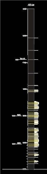
3 Background 3-5 km wide and 100 km long channel belt Oligocene to Early Miocene deposits (2000 m) Deposits: Conglomerates, sandstone and mudstone Accumulated within Ma (Martini, 1971) Channel belt flows to the east Flow 25 modified Zweigel et al.,1998; Hubbard et al.,2009 modified from De Ruig and Hubbard, 2006; Bernhdart, 2011


4 Background foreland basin Area of study deepens towards the active Alpine thrust front to the south and shallows to the north overbank and crevasse-splay sediments deposited by flows that spilled out of the main axial channel 25 modified Zweigel et al.,1998; Hubbard et al.,2009
5 Research objectives 1. Depositional mechanisms & environment of sediment accumulation in the studied fields How the lobes were deposited? Over spilling vs. breaching of the levee 2. Architecture of overbank deposits basin or channel-belt configuration influence on distribution of over-bank deposits 3. Spatial variation and lithological heterogeneity of out-of-channel deposits Predict the sandstone in the overbank area of the Molasse Basin


6 Lithofacies Thick-bedded sandstone. Beds are >50 cm thick and are >80% sandstone. Laminated mudstone with <20% sandstone With pebbles & mud clasts Massive and Bouma divisions


7 Lithofacies Thin-bedded sandstone & mudstone Slurry-beds, slumps, and debris flows Sandstone beds 5-50 cm thick, >20% sandstone sandstone beds <5 cm, >20% sandstone


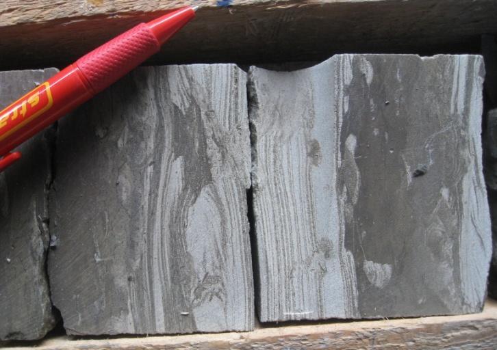
8 Core: A A-40


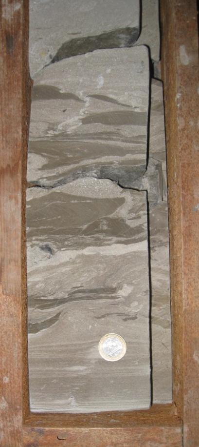
9 Core: S S- 4 RAG courtesy
 87% 0% Average sand 57% Average")


10 Quantitative analysis Time 1 Time 2 (modified from Droser & Botjjer, 1989) 87% 0% Average sand 57% Average Mud 43% Average Bioturbation 7% meters B 44, K % Sand Bioturbation
11 Quantitative analysis meters A 40, K1 Average sand 14.6% Average Mud 85% Average Bioturbation 9% A 40, K m m Average sand 23% Average Mud 76.5% Average Bioturbation 12.8% Sand Sand Bioturbation Bioturbation % meters % A20,K1 A20,K2 Time 1 Time 2
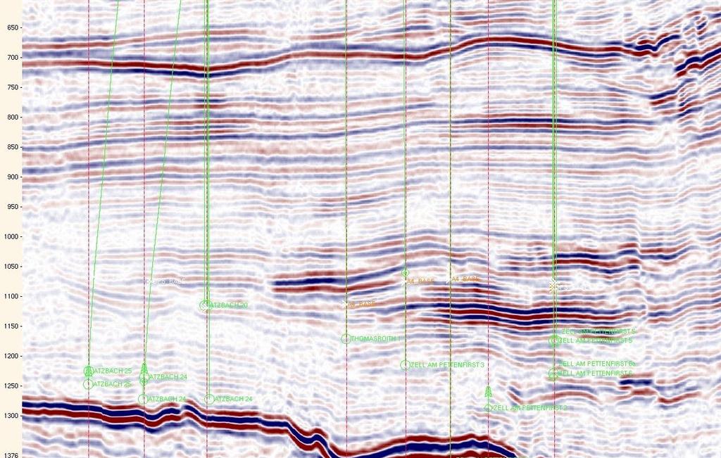


12 Completion logs and 3-D seismic Base of Hall Formation A-40 Z-12 A-40 Z-12

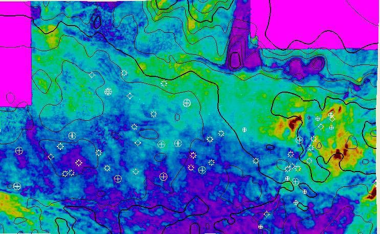
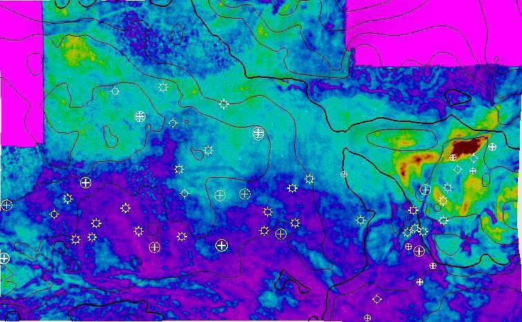
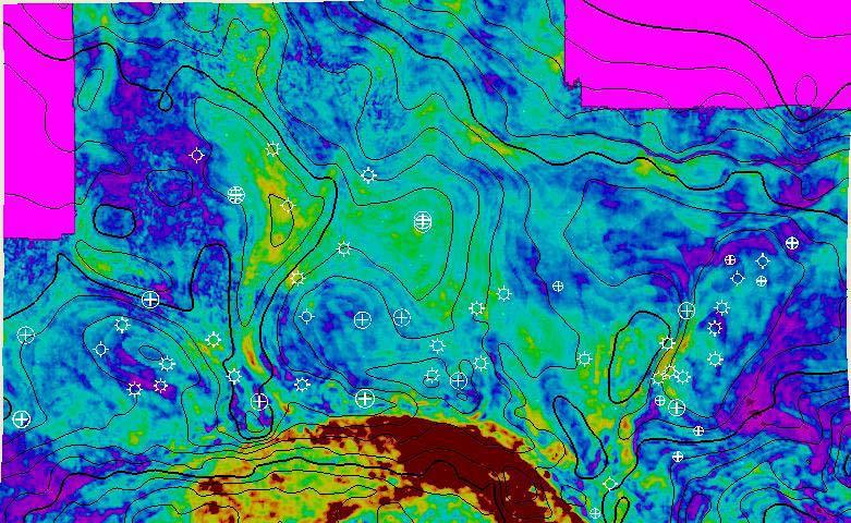
13 Seismic interpretation 8 horizons ms between horizons RMS amplitudes extracted from each horizon and between horizons Exploration interest A1-2 A3 A4 L. Puch


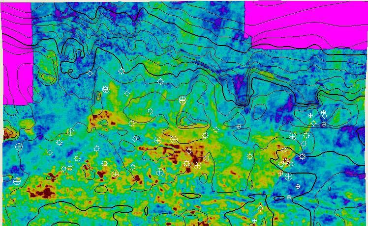


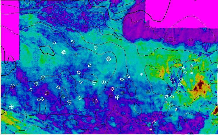


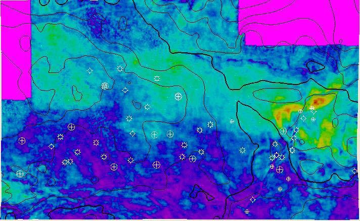


14 Seismic interpretation A1- Base of Hall Fm 2.5 km N A) 40 60m lower A3; B) lower A2 C) A1 interval (Hubbard et al., 2009) Background Research objectives Core and well logs Seismic Interpretations Conclusions

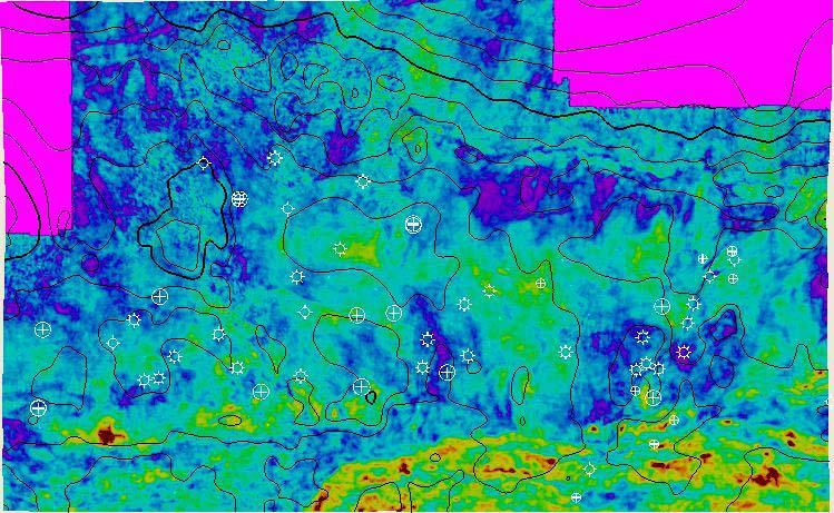
15 Seismic interpretation A4 interval N 2.5 km 1??? 2 1 2
16 interpretation Three hypotheses: 1) Flows from the channel crevasse splays 2) Flows into the channel tributary channels 3) Slumps remnants: originated from the sides of the channel, slumps were carried away by the flow in the channel and the space was filled with subsequent flows 2.5 km


 development of a number of")

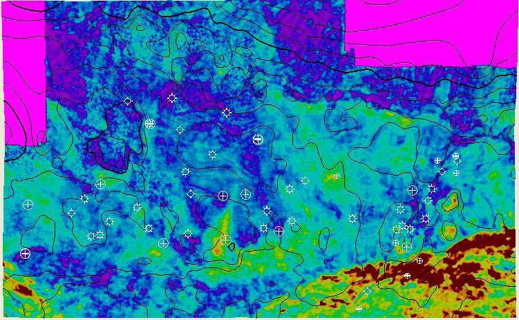
17 Seismic interpretation Overbank deposition of the Upper Puchkirchen Formation can be subdivided into 3 steps from older to younger deposits: (1) deposition of multiple interfingering splays associated with erosional features directed perpendicular to the channel, (2) deposition of a single large splay on the north side of the channel, (3) development of a number of channels across the previous splay surfaces. 1 Base of the Upper Puchkirchen Fm Middle of the Upper Puchkirchen Fm 2 3 Top of the Upper Puchkirchen Fm
18 Conclusions 1. 4 lithofacies represent the core in the Puchkirchen Formation of the studied gas fields: Thin beds of sandstone & mudstone is the most common. 2. Low-density turbidity currents - sediment deposition far from the channel setting, high-density turbidity currents deposits - close to channel. 3. Slurry flows, debris flows & conglomerates is a sign of erosion (crevasse splay?) 4. Bioturbation intensity increases (?) and sand amount decreases with distance from channel. 5. Overbank deposits appear at the outer bank to the north of the channel. 6. The evolution of overbank deposits follow 3 stages: (1) deposition of multiple interfingering splays associated with erosional features (?) directed perpendicular to the channel, (2) deposition of a single large splay on the north side of the channel, (3) development of a number of channels across the previous splay surfaces.


19 Acknowledgement RAG personnel: Katarina Borowski, Nicola Kofler, Wolfgang Mitterlehner, Ulrich Bieg, Ralph Hinsch, Wolfgang Nachtmann, Olga Wronska, Wilma Troiss, Réka Kovách SPODDS Students: Blair Burgreen, Julie Fosdick, Katie Maier, Matt Malkowski, Nora Nieminski, Jon Rotzien Theresa Schwartz, Lauren Shumaker, Danielle Zentner Dominic Armitage Anne Bernhardt Zane Jobe Lisa Stright
20 Thank you for your attention! QUESTIONS?


21 Seismic interpretation A1-Hall Base 2.5 km N A) 40 60m lower A3; B) lower A2 C) A1 interval (Hubbard et al., 2009)
PATTERN BASED GEOLOGICAL MODELING OF DEEP WATER CHANNEL DEPOSITS IN THE MOLASSE BASIN, UPPER AUSTRIA. Lisa Stright
 PATTERN BASED GEOLOGICAL MODELING OF DEEP WATER CHANNEL DEPOSITS IN THE MOLASSE BASIN, UPPER AUSTRIA Lisa Stright Graduate Program in Earth, Energy and Environmental Sciences, Stanford University, Stanford,
Large-Scale Stratigraphic Architecture of a Deep-Water Slope Conduit, Nanaimo Group, Hornby Island, Canada
 Large-Scale Stratigraphic Architecture of a Deep-Water Slope Conduit, Nanaimo Group, Hornby Island, Canada Heather A. Bain 1 and Stephen M. Hubbard 1 1 Department of Geoscience, University of Calgary Introduction
Seismic Expressions of Submarine Channel - Levee Systems and Their Architectural Elements
 Seismic Expressions of Submarine Channel - Levee Systems and Their Architectural Elements Summary D.V. Ramana, Santanu De* and Kalyanbrata Datta KDMIPE, ONGC, Dehradun E-mail- devvenram@rediffmail.com
Outcrops from Every Continent and 20 Countries in 140 Contributions. Tor H. Nilsen, Roger D. Shew, Gary S. Steffens, and Joseph R.J. Studlick.
 Paper VIII Tor H. Nilsen, Roger D. Shew, Gary S. Steffens, and Joseph R.J. Studlick Editors Outcrops from Every Continent and 20 Countries in 140 Contributions http://bookstore.aapg.org Length ~ 23 m (75.5
The 3-D Seismic Geomorphology of Deep-Water Slope Channel Systems A Case Study from the Deep Water Nile Delta
 Geological Society of Trinidad & Tobago The 3-D Seismic Geomorphology of Deep-Water Slope Channel Systems A Case Study from the Deep Water Nile Delta Nigel E. Cross Presentation Outline Introduction Deep
Deep Water Systems and Sequence Stratigraphy. By: Matt Kyrias, Chris Majerczyk, Nick Whitcomb, Wesley Vermillion
 Deep Water Systems and Sequence Stratigraphy By: Matt Kyrias, Chris Majerczyk, Nick Whitcomb, Wesley Vermillion Contents Gravity Flow Depositional Elements Defined References NOTE: Source uses seismic
Bulletin of Earth Sciences of Thailand
 Quantitative Seismic Geomorphology of Early Miocene to Pleistocene Fluvial System of Northern Songkhla Basin, Gulf of Thailand Oanh Thi Tran Petroleum Geoscience Program, Department of Geology, Faculty
Turbidite Fasies of Lower Penosogan Formation in Karanggayam Area, Kebumen, Indonesia
 Modern Applied Science; Vol. 12, No. 6; 2018 ISSN 1913-1844 E-ISSN 1913-1852 Published by Canadian Center of Science and Education Turbidite Fasies of Lower Penosogan Formation in Karanggayam Area, Kebumen,
Geostatistically modeling topographicallycontrolled deposition of sub-seismic scale sandstone packages within a mass transport dominated deepwater
 Geostatistically modeling topographicallycontrolled deposition of sub-seismic scale sandstone packages within a mass transport dominated deepwater channel belt Lisa Stright 1, Anne Bernhardt 2, and Alexandre
Using new facies architecture models and geochemical data constraints to reconstruct Kupe and Kapuni field charge dynamics
 Using new facies architecture models and geochemical data constraints to reconstruct Kupe and Kapuni field charge dynamics Karsten Kroeger, Richard Sykes, Malcolm Arnot, Miko Fohrmann, Matt Hill Studying
Qvc Twf. Alaska Division of Geological & Geophysical Surveys. Reger s Geologic Consulting, Soldotna, AK
 SEDIMENTOLOGY, AGE, AND GEOLOGIC CONTEXT OF A PLEISTOCENE VOLCANICLASTIC SUCCESSION NEAR SPURR VOLCANO, ALASKA Qvc Twf Trystan M. Herriott 1, Christopher J. Nye 1, Richard D. Reger 2, Marwan A. Wartes
Geologic Model and Reservoir Description of the Deepwater "P Sand" at Subsalt Mahogany Field, Gulf of Mexico
 Geologic Model and Reservoir Description of the Deepwater "P Sand" at Subsalt Mahogany Field, Gulf of Mexico Wayne K. Camp, Anadarko Petroleum Corporation Abstract An integrated conceptual geologic model
Bulletin of Earth Sciences of Thailand
 Depositional Environments and Stratigraphic Development of the Grand Taman Sari Circuit Outcrop: an Analogue for Transgressive Mahakam Delta Successions Ridha Santika Riadi Petroleum Geoscience Program,
Study of the impact of heterogeneity on the modeling of fluid-flow, based on a turbidite reservoir analogue Ainsa-1 quarry outcrop, Spain
 Study of the impact of heterogeneity on the modeling of fluid-flow, based on a turbidite reservoir analogue Ainsa-1 quarry outcrop, Spain Master of Sciences thesis Submitted by: Erica Garrido Magaz In
BALOCHISTAN FOLDBELT BASIN
 INTRODUCTION BALOCHISTAN FOLDBELT BASIN The Kharan-3 block is located in the Kharan Trough of Balochistan Basin. GEOLOGICAL SETTING The Balochistan Province is an Upper Cretaceous to Recent structurally
Interpreting deepwater sedimentary facies using borehole images: a case study of Tertiary deepwater deposits from Godavari Basin, East Coast of India
 P - 415 Interpreting deepwater sedimentary facies using borehole images: a case study of Tertiary deepwater deposits from Godavari Basin, East Coast of India Ashish Kundu, Sudipta Dasgupta*, Neeraj Sinha,
The Hydrologic Cycle
 CONTINENTAL DEPOSITIONAL ENVIRONMENTS fluvial desert lacustrine (lake) Glacial KEY PARAMETERS (VARIABLES) 1. Climate (Hydrologic Cycle) Annual Precip vs. Seasonality 2. Tectonics (Mountains) The Hydrologic
Synthetic Seismic Modeling of Turbidite Outcrops
 7 Synthetic Seismic Modeling of Turbidite Outcrops Mark Chapin and Gottfried Tiller Shell International Exploration and Production, Inc., Houston, Texas, USA Executive Summary Seismic forward models of
Characteristics of the Sedimentary Microfacies of Fuyu Reservoir in Yushulin Oilfield, Songliao Basin
 IOSR Journal of Engineering (IOSRJEN) ISSN (e): 2250-3021, ISSN (p): 2278-8719 Vol. 06, Issue 03 (March. 2016), V3 PP 01-05 www.iosrjen.org Characteristics of the Sedimentary Microfacies of Fuyu Reservoir
Facies Analysis of the Lower Cretaceous Wilrich Member (Lower Falher) of the Spirit River Formation.
 of the Spirit River Formation.") Facies Analysis of the Lower Cretaceous Wilrich Member (Lower Falher) of the Spirit River Formation. Kerrie L. Bann, Ichnofacies Analysis Inc. and Daniel J. K. Ross, Tourmaline Oil Corp. Historically,
Facies Analysis of the Lower Cretaceous Wilrich Member (Lower Falher) of the Spirit River Formation. Kerrie L. Bann, Ichnofacies Analysis Inc. and Daniel J. K. Ross, Tourmaline Oil Corp. Historically,
TERRESTRIAL AND SHALLOW-MARINE DEPOSITS OF CENTRAL- CARPATHIAN PALEOGENE BASIN: EXAMPLE FROM EASTERN SLOVAKIA J. JANOČKO
 TERRESTRIAL AND SHALLOW-MARINE DEPOSITS OF CENTRAL- CARPATHIAN PALEOGENE BASIN: EXAMPLE FROM EASTERN SLOVAKIA J. JANOČKO Geological Survey of Slovak Republic, Jesenského 8, 040 11 Košice, Slovakia Abstract:
3D geologic modelling of channellized reservoirs: applications in seismic attribute facies classification
 first break volume 23, December 2005 technology feature 3D geologic modelling of channellized reservoirs: applications in seismic attribute facies classification Renjun Wen, * president and CEO, Geomodeling
Bikashkali Jana*, Sudhir Mathur, Sudipto Datta
 10 th Biennial International Conference & Exposition P 354 Facies characterization of a low permeability Cretaceous clastic reservoir to understand reservoir spatial distribution in the Nagayalanka Field,
Sedimentation Dynamics and Stratigraphy of the Middle Breton Sound Estuary, Southeastern Louisiana: Spatiotemporal Evidence for Subdeltaic Evolution
 Sedimentation Dynamics and Stratigraphy of the Middle Breton Sound Estuary, Southeastern Louisiana: Spatiotemporal Evidence for Subdeltaic Evolution Edwin J. Bomer IV 1, Samuel J. Bentley 1,2, Kehui Xu
Facies Analysis Of The Reservoir Rocks In The. Sylhet Trough, Bangladesh. Abstract
 Facies Analysis Of The Reservoir Rocks In The Sylhet Trough, Bangladesh Joyanta Dutta Petroleum Geoscience Program, Department of Geology, Faculty of Science, Chulalongkorn University, Bangkok 10330, Thailand
Facies Modeling in Presence of High Resolution Surface-based Reservoir Models
 Facies Modeling in Presence of High Resolution Surface-based Reservoir Models Kevin Zhang Centre for Computational Geostatistics Department of Civil and Environmental Engineering University of Alberta
Main Challenges and Uncertainties for Oil Production from Turbidite Reservoirs in Deep Water Campos Basin, Brazil*
 Main Challenges and Uncertainties for Oil Production from Turbidite Reservoirs in Deep Water Campos Basin, Brazil* Carlos H. Bruhn 1, Antonio Pinto 1, and Paulo R. Johann 1 Search and Discovery Article
Image: G. Parker. Presenters: Henry Chan, Kayla Ireland, Mara Morgenstern, Jessica Palmer, Megan Scott
 Image: G. Parker Presenters: Henry Chan, Kayla Ireland, Mara Morgenstern, Jessica Palmer, Megan Scott Is the Ross Formation a suitable analog for sand-rich turbidite plays in passive margin basins? Play:
The Stratigraphic Trap in the Benchamas Field Pattani Basin, Gulf of Thailand
 The Stratigraphic Trap in the Benchamas Field Pattani Basin, Gulf of Thailand Jurairat Buangam Petroleum Geoscience Program, Department of Geology, Faculty of Science, Chulalongkorn University, Bangkok
Sedimentary System Characteristics of Deng-3 Section on Paleo-central. Uplift Belt in Northern Songliao Basin. Siyang Li1,a*
 Sedimentary System Characteristics of Deng-3 Section on Paleo-central Uplift Belt in Northern Songliao Basin Siyang Li1,a* 1 School of Earth Sciences and Resources, China University of Geosciences, Beijing,
Fluid-Mud Deposits of the Lower Jurassic Tilje Formation, Offshore Mid-Norway By Aitor A. Ichaso and Robert W. Dalrymple 1
 Fluid-Mud Deposits of the Lower Jurassic Tilje Formation, Offshore Mid-Norway By Aitor A. Ichaso and Robert W. Dalrymple 1 Search and Discovery Article #50107 (2008) Posted August 10, 2008 *Adapted from
Case Study of the Structural and Depositional-Evolution Interpretation from Seismic Data*
 Case Study of the Structural and Depositional-Evolution Interpretation from Seismic Data* Yun Ling 1, Xiangyu Guo 1, Jixiang Lin 1, and Desheng Sun 1 Search and Discovery Article #20143 (2012) Posted April
Modeling Lateral Accretion in McMurray Formation Fluvial- Estuarine Channel Systems: Grizzly Oil Sands May River SAGD Project, Athabasca
 Modeling Lateral Accretion in McMurray Formation Fluvial- Estuarine Channel Systems: Grizzly Oil Sands May River SAGD Project, Athabasca Duncan Findlay, Thomas Nardin, Alex Wright, Raheleh Salehi Mojarad
The San Benito Gravels: Fluvial Depositional Systems, Paleocurrents, and Provenance
 ES120 FIELD TRIP #2 10 April 2010 NAME: The San Benito Gravels: Fluvial Depositional Systems, Paleocurrents, and Provenance Introduction The San Benito Gravels (SBG) consists of a 500 m thick section of
ENHANCED RESERVOIR CHARACTERIZATION IN A DEEP WATER TURBIDITE SYSTEM USING BOREHOLE IMAGES AND SPECTROSCOPY LOGS
 ENHANCED RESERVOIR CHARACTERIZATION IN A DEEP WATER TURBIDITE SYSTEM USING BOREHOLE IMAGES AND SPECTROSCOPY LOGS Indrajit Basu 1, Nigel Machin 1, Anil Tyagi 2, Kamlesh Saxena 2, Raphael Altman 1, Alex
Prof Bryan T CRONIN Principal Geologist 2 Tullow Ghana Ltd
 Entrenched slope channel complex systems: Reservoir opportunities through understanding architectural element distribution and application to West Africa E&P Prof Bryan T CRONIN Principal Geologist 2 Tullow
The low resistive Tertiary clastic reservoirs in KG Basin, India a challenge towards Hydrocarbon Explorations
 10 th Biennial International Conference & Exposition P 041 The low resistive Tertiary clastic reservoirs in KG Basin, India a challenge towards Hydrocarbon Explorations Dr. K. Yadagiri*, A. D. Mohanty,
GeoCanada 2010 Working with the Earth
 Lithofacies Identification and the Implications for SAGD Well Planning in the McMurray Formation, Christina Lake Area, Alberta Travis Shackleton*, Robert Gardner, Sung Youn, Grace Eng and Lori Barth Cenovus
Chapter 8: Learning objectives
 Chapter 8: Learning objectives Understand concept of sedimentary facies Signinifance of lateral and vertical facies associations Walther s Law Understand the sedimentary facies of alluvial fans, eolian
Southern Songkhla Basin, Gulf of Thailand
 Architecture and Depositional Environment of Fluvial Systems of Southern Songkhla Basin, Gulf of Thailand Toan Manh Do Petroleum Geoscience Program, Department of Geology, Faculty of Science, Chulalongkorn
Reservoir characterization
 1/15 Reservoir characterization This paper gives an overview of the activities in geostatistics for the Petroleum industry in the domain of reservoir characterization. This description has been simplified
Characteristic of the deep-water channels in the Lower Miocene Pulau Balang Formation in Samarinda
 Characteristic of the deep-water channels in the Lower Miocene Pulau Balang Formation in Samarinda Abdurrokhim*, Djadjang J Setiadi, Faisal Helmi, Adi Hardiyono, and Yoga A Sendjaja Faculty of Geology,
SUPPLEMENTAL MATERIAL
 SUPPLEMENTAL MATERIAL DESCRIPTIONS OF OTHER STRATIGRAPHIC SECTIONS Cherry Creek In its middle reaches, Cherry Creek meanders between three paired terraces within a narrow bedrock valley. The highest is
Marine and Petroleum Geology
 Marine and Petroleum Geology 28 (2011) 761e784 Contents lists available at ScienceDirect Marine and Petroleum Geology journal homepage: www.elsevier.com/locate/marpetgeo Sediment waves and depositional
High Resolution Field-based Studies of Hydrodynamics Examples from the North Sea
 High Resolution Field-based Studies of Hydrodynamics Examples from the North Sea Stephen O Connor 1, Richard Swarbrick 2 and Sam Green 1 1 Ikon GeoPressure, Durham, UK 2 Swarbrick Geopressure Consultancy,
Introduction to sequence stratigraphy and its application to reservoir geology
 Introduction to sequence stratigraphy and its application to reservoir geology Massimo Zecchin Istituto Nazionale di Oceanografia e di Geofisica Sperimentale - OGS Historical development Definitions Systems
Source- to- Sink in the Stra/graphic Record
 Source- to- Sink in the Stra/graphic Record Capturing the Long-Term, Deep-Time Evolution of Sedimentary Systems Stephan A. Graham Stanford University Brian W. Romans Chevron Energy Technology Co. Jacob
ES120 Sedimentology/Stratigraphy
 Midterm Exam 5/05/08 NAME: 1. List or describe 3 physical processes that contribute to the weathering of rocks (3pts). exfoliation frost wedging many others. roots, thermal expansion/contraction also credit
High-resolution Sequence Stratigraphy of the Glauconitic Sandstone, Upper Mannville C Pool, Cessford Field: a Record of Evolving Accommodation
 Page No. 069-1 High-resolution Sequence Stratigraphy of the Glauconitic Sandstone, Upper Mannville C Pool, Cessford Field: a Record of Evolving Accommodation Thérèse Lynch* and John Hopkins, Department
Vail et al., 1977b. AAPG 1977 reprinted with permission of the AAPG whose permission is required for further use.
 Well 5 Well 4 Well 3 Well 2 Well 1 Vail et al., 1977b AAPG 1977 reprinted with permission of the AAPG whose permission is required for further use. Well 5 Well 4 Well 3 Well 2 Well 1 Vail et al., 1977b
Modeling Lateral Accretion in the McMurray Formation at Grizzly Oil Sands Algar Lake SAGD Project
 Modeling Lateral Accretion in the McMurray Formation at Algar Lake SAGD Project Duncan Findlay 1, Thomas Nardin 1, Andrew Couch 2, Alex Wright 1 1 ULC, 2 EON Introduction Laterally accreting channel systems
=%REPORT RECONNAISSANCE OF CHISHOLM LAKE PROSPECT. October 25, 1977
 =%REPORT ON FIELD RECONNAISSANCE OF CHISHOLM LAKE PROSPECT October 25, 1977 Bruce D. Vincent Imperial Oil Limited, Minerals - Coal, CALGARY, ALBERTA CHISHOLM LAKE PROSPECT Introduction The Chisholm Lake
FACIES AND ARCHITECTURAL ASYMMETRY IN A CONGLOMERATE-RICH SUBMARINE CHANNEL FILL, CERRO TORO FORMATION, SIERRA DEL TORO, MAGALLANES BASIN, CHILE
 Journal of Sedimentary Research, 2010, v. 80, 1085 1108 Research Article DOI: 10.2110/jsr.2010.092 FACIES AND ARCHITECTURAL ASYMMETRY IN A CONGLOMERATE-RICH SUBMARINE CHANNEL FILL, CERRO TORO FORMATION,
Sedimentary and Stratigraphic Analysis of the Viking Sand in the Edgerton/Wainwright Area, Central Alberta* By Russell Walz 1
 Sedimentary and Stratigraphic Analysis of the Viking Sand in the Edgerton/Wainwright Area, Central Alberta* By Russell Walz 1 Search and Discovery Article #50030 (2006) Posted June 25, 2006 *Extended abstract
Data Repository item
 Data Repository (B25407): Localities and descriptions of measured sections of study areas Table 1. Localities of the measured sedimentary sections in the NW Sichuan Basin Section Number Stratigraphy Locality
Quick Look : Rule Of Thumb of Rock Properties in Deep Water, Krishna-Godavari Basin
 5th Conference & Exposition on Petroleum Geophysics, Hyderabad-2004, India PP 576-581 Quick Look : Rule Of Thumb of Rock Properties in Deep Water, Krishna-Godavari Basin Acharya M. N. 1, Biswal A. K. 1
AUSTRIAN JOURNAL of EARTH SCIENCES
 AUSTRIAN JOURNAL of EARTH SCIENCES [MITTEILUNGEN der ÖSTERREICHISCHEN GEOLOGISCHEN GESELLSCHAFT] an INTERNATIONAL JOURNAL of the AUSTRIAN GEOLOGICAL SOCIETY volume 98 2005 Stephen M. HUBBARD, Menno J.
UPPER MANZANILLA FORMATION AT FISHING POND VILLAGE FIELDTRIP GUIDE
 UPPER MANZANILLA FORMATION AT FISHING POND VILLAGE FIELDTRIP GUIDE Saturday 10 th March 2012 Trip Leader: Georgia Huggins INTRODUCTION MANZANILLA Formation Author of name: WARING (G.A.) (1926.). The geology
Lecture 19: Fluvial Facies
 GEOL 440 Sedimentology and stratigraphy: processes, environments and deposits Lecture 19: Fluvial Facies Aims Examine controls on alluvial channel pattern List the types of channel pattern Examine meandering
SUMMARY INTRODUCTION METHODOLOGY
 Kamal Hami-Eddine*, Pascal Klein, Loic Richard, Paradigm, Andrew Furniss, AWE Limited SUMMARY Automatic seismic facies classification is now common practice in the oil and gas industry. Unfortunately unsupervised
The Research of Sedimentary Micro-facies in PuTaoHua Reservoir of. GuLongNan Area. XinYao Ju 1, a *, Lulu Tu 2
 3rd International Conference on Management, Education, Information and Control (MEICI 2015) The Research of Sedimentary Micro-facies in PuTaoHua Reservoir of GuLongNan Area XinYao Ju 1, a *, Lulu Tu 2
Facies and architectural asymmetry of a submarine channel fill, Cerro Toro Formation, FACIES AND ARCHITECTURAL ASYMMETRY IN A CONGLOMERATE-RICH
 Facies and architectural asymmetry of a submarine channel fill, Cerro Toro Formation, Chile FACIES AND ARCHITECTURAL ASYMMETRY IN A CONGLOMERATE-RICH SUBMARINE CHANNEL FILL, CERRO TORO FORMATION, SIERRA
Depositional elements associated with a basin floor channel-levee system: case study from the Gulf of Mexico
 Marine and Petroleum Geology 20 (2003) 677 690 www.elsevier.com/locate/marpetgeo Depositional elements associated with a basin floor channel-levee system: case study from the Gulf of Mexico Henry W. Posamentier
Recent developments in object modelling opens new era for characterization of fluvial reservoirs
 Recent developments in object modelling opens new era for characterization of fluvial reservoirs Markus L. Vevle 1*, Arne Skorstad 1 and Julie Vonnet 1 present and discuss different techniques applied
Gravity Flow Sedimentary Characteristics of Chang 6 in Panke Area, Ordos Basin
 Ekoloji 27(106): 727-734 (2018) Gravity Flow Sedimentary Characteristics of Chang 6 in Panke Area, Ordos Basin Shasha Yang 1, Xuri Huang 1*, Cheng Yin 1, Yongqiang Xu 2, Juan Song 3, Runrong Cao 3 1 School
NAME: GEL 109 Final Winter 2010
 GEL 109 Final Winter 2010 1. The following stratigraphic sections represents a single event followed by the slow accumulation of background sedimentation of shale. Describe the flows that produced the
Controls on facies distributions in the Charlie Lake Formation, Peace River Arch, Alberta
 Controls on facies distributions in the Charlie Lake Formation, Peace River Arch, Alberta E.L. Percy 12, C. Frostad 2, A. Juska 2, C. Schmidt 2, C. Sitzler 2, and J.P. Zonneveld 3 University of Calgary,
Discovery of vast fluvial deposits provides evidence for. drawdown during the late Miocene Messinian salinity crisis
 1 2 3 4 5 6 7 GS ata Repository 2019062 iscovery of vast fluvial deposits provides evidence for drawdown during the late Miocene Messinian salinity crisis ndrew S. Madof 1, laudia ertoni 2, and Johanna
EGAS. Ministry of Petroleum
 EGAS Ministry of Petroleum EGAS Ministry of Petroleum About The Block Location: N. Thekah offshore block is located at about 56 km to the north of the Mediterranean shore line, 85 km to the north west
Nathan D. Webb and James L. Best
 Nathan D. Webb and James L. Best Background Pennsylvanian oil production Stratigraphy & geologic setting Study area Methods Using geophysical logs & core Results Comparing three channel deposits Implications
Marine and Petroleum Geology
 Marine and Petroleum Geology 28 (2011) 728e743 Contents lists available at ScienceDirect Marine and Petroleum Geology journal homepage: www.elsevier.com/locate/marpetgeo Architecture of turbidite channel
Rapid progradation of the Pliocene-Pleistocene continental margin, northern Taranaki Basin, New Zealand, and implications
 Rapid progradation of the Pliocene-Pleistocene continental margin, northern Taranaki Basin, New Zealand, and implications RJ Hansen 1, and PJJ Kamp 1 1 Department of Earth Sciences, The University of Waikato,
Climbing-ripple successions in turbidite systems: depositional environments, sedimentation rates and accumulation times
 Sedimentology (2012) 59, 867 898 doi: 10.1111/j.1365-3091.2011.01283.x Climbing-ripple successions in turbidite systems: depositional environments, sedimentation rates and accumulation times ZANE R. JOBE*,1,
Luca Giacomo Costamagna. Journal of Mediterranean Earth Sciences
 doi: 10.3304/JMES.2018.003 Journal of Mediterranean Earth Sciences 10 (2018), 129-134 Journal of Mediterranean Earth Sciences Investigation methods on continental outcrops: developing an upgrade of the
EGAS. Ministry of Petroleum
 EGAS Ministry of Petroleum EGAS Ministry of Petroleum About The Block Location: N. El Arish offshore block is located in the extreme eastern part of the Egypt s economic water border and bounded from the
Sand Body Description for Upper Sangonghe Formation (Early Jurassic), Baolang Oilfield, Yanqi Basin Northwest China
, Baolang Oilfield, Yanqi Basin Northwest China") Sand Body Description for Upper Sangonghe Formation (Early Jurassic), Baolang Oilfield, Yanqi Basin Northwest China Fahd A. Q. Al-Qaraafi and Yao Guangqing II. GEOLOGICAL SETTING Abstract The Yanqi Basin
Sand Body Description for Upper Sangonghe Formation (Early Jurassic), Baolang Oilfield, Yanqi Basin Northwest China Fahd A. Q. Al-Qaraafi and Yao Guangqing II. GEOLOGICAL SETTING Abstract The Yanqi Basin
Exploration, Drilling & Production
 Nontechnical Guide to PETMOLEUM Geology, Exploration, Drilling & Production Third Edition Norman J. Hyne, Ph.D. Contents Preface *i Introduction 1 The Nature of Gas and Oil 1 Petroleum 1 The Chemistry
Keywords: Geobody Modeling, Object-Based Facies Modeling (OBFM), Variogram Analysis, Farewell Formation, Paleo-depositional Environment.
, Variogram Analysis, Farewell Formation, Paleo-depositional Environment.") 1 2 3 4 5 6 7 8 9 10 11 12 13 14 15 16 17 18 19 20 21 22 23 24 25 26 27 28 29 30 31 32 33 34 35 36 37 38 39 40 41 42 Type of the Paper (Article) Three-Dimensional Facies Analysis using Object-Based Geobody
1 2 3 4 5 6 7 8 9 10 11 12 13 14 15 16 17 18 19 20 21 22 23 24 25 26 27 28 29 30 31 32 33 34 35 36 37 38 39 40 41 42 Type of the Paper (Article) Three-Dimensional Facies Analysis using Object-Based Geobody
Daniel Koning, Peggy Johnson, and John Hawley. New Mexico Bureau of Geology and Mineral Resources
 Daniel Koning, Peggy Johnson, and John Hawley Daniel Koning 1, Gary Smith 2, and Adam Read 1 1 New Mexico Bureau of Geology and Mineral Resources 2 University of New Mexico Santa Fe Group Definition (Spiegel
Sequence Stratigraphic Framework and Reservoir Architecture of the Lingshui-3 Member, Yacheng 13-1 Gas Field, South China Sea
 Sequence Stratigraphic Framework and Reservoir Architecture of the Lingshui-3 Member, Yacheng 13-1 Gas Field, South China Sea David Z. Tang BP China Exploration and Production Company 17/F, Finance Centre,
The Hydrocarbon case For Lebanon. Neil Hodgson. Feb 2013
 The Hydrocarbon case For Lebanon Neil Hodgson Feb 2013 Spectrum s 2D and 3D Multi Client Mediterranean dataset Lebanon 3D Phase 1: (2320 sq km) full fold data Acquisition in 1 month, 77sq km/day Acquired
2002 GCSSEPM Foundation Ed Picou Fellowship Grant for Graduate Studies in the Earth Sciences Recipient. David Pyles
 2002 GCSSEPM Foundation Ed Picou Fellowship Grant for Graduate Studies in the Earth Sciences Recipient David Pyles David Pyles is a Ph.D. student in the Energy and Minerals Applied Research Center at the
Sedimentology, lithofacies analysis and depositional model of Baz-e-Hour river, SW Mashhad
 Sedimentology, lithofacies analysis and depositional model of Baz-e-Hour river, SW Mashhad Saif Allah Alami 1, Mehdi Reza Poursoltani 2, Seied Mohammad Javad Moosavi 3 1- Department of geology, Faculty
Stochastic Simulation of Inclined Heterolithic Stratification with Streamline-based Stochastic Models
 Stochastic Simulation of Inclined Heterolithic Stratification with Streamline-based Stochastic Models Michael J. Pyrcz and Clayton V. Deutsch Department of Civil and Environmental Engineering, University
Geology Stratigraphic Correlations (Lab #4, Winter 2010)
") Name: Answers Reg. lab day: Tu W Th Geology 1023 Stratigraphic Correlations (Lab #4, Winter 2010) Introduction Stratigraphic correlation is the process of comparing rocks at one locality with related rocks
Name: Answers Reg. lab day: Tu W Th Geology 1023 Stratigraphic Correlations (Lab #4, Winter 2010) Introduction Stratigraphic correlation is the process of comparing rocks at one locality with related rocks
A.K. Khanna*, A.K. Verma, R.Dasgupta, & B.R.Bharali, Oil India Limited, Duliajan.
 P-92 Application of Spectral Decomposition for identification of Channel Sand Body in OIL s operational area in Upper Assam Shelf Basin, India - A Case study A.K. Khanna*, A.K. Verma, R.Dasgupta, & B.R.Bharali,
Production characteristics of sheet and channelized turbidite reservoirs, Garden Banks 191, Gulf of Mexico
 CORNER INTERPRETER S Production characteristics of sheet and channelized turbidite reservoirs, Garden Banks 191, Gulf of Mexico DAVID S. FUGITT, JAMES E. FLORSTEDT, GARY J. HERRICKS, and MICHAEL R. WISE,
Rio Tinto Coal Mozambique. Refining the sedimentological model of the Moatize Basin Sediments, Stratigraphy & Coal
 Rio Tinto Coal Mozambique Refining the sedimentological model of the Moatize Basin Sediments, Stratigraphy & Coal Cautionary Statement This presentation has been prepared by Rio Tinto plc and Rio Tinto
Determination of uplift rates of fluvial terraces across the Siwaliks Hills, Himalayas of central Nepal
 Determination of uplift rates of fluvial terraces across the Siwaliks Hills, Himalayas of central Nepal Martina Böhme Institute of Geology, University of Mining and Technology, Freiberg, Germany Abstract.
DOWNSTREAM SORTING OF SEDIMENT (additional control on channel width, depth and slope)
") DOWNSTREAM SORTING OF SEDIMENT (additional control on channel width, depth and slope) Image removed due to copyright concerns As the gravel gets finer, it is transported at lower slopes. The result is
DOWNSTREAM SORTING OF SEDIMENT (additional control on channel width, depth and slope) Image removed due to copyright concerns As the gravel gets finer, it is transported at lower slopes. The result is
Apache Egypt Companies. The introduction of 3D seismic techniques three decades ago greatly enhanced our
 Structure architecture interpretation of the middle Frio Formation using 3D seismic attributes and well logs: an example from the Texas Gulf Coast of the United States HAMED EL-MOWAFY 1 and KURT J. MARFURT
The Late Tertiary Deep-Water Siliciclastic System of the Levant Margin - An Emerging Play Offshore Israel*
 The Late Tertiary Deep-Water Siliciclastic System of the Levant Margin - An Emerging Play Offshore Israel* Michael A. Gardosh 1, Yehezkel Druckman 2 and Binyamin Buchbinder 2 Search and Discovery Article
A 2-D Petroleum System Model for the Vallecitos Syncline, San Joaquin Basin, California *
 A 2-D Petroleum System Model for the Vallecitos Syncline, San Joaquin Basin, California * Meng He 1, Stephan Graham 1, J. Michael Moldowan 1, Kenneth E. Peters 1, Leslie B. Magoon 1, Carolyn Lampe 1, and
RELINQUISHMENT REPORT. License P1546 Block April 2009
 RELINQUISHMENT REPORT License P1546 Block 110-01 14 April 2009 Sherritt International Oil and Gas Limited 2000, 425-1 st street S.W., Calgary, Alberta Canada T2P 3L8 Telephone (403) 260-2900 Fax (403)
LONG ISLAND CLAST ORIENTATIONS
 LONG ISLAND CLAST ORIENTATIONS AND WHAT THEY TILL US Elliot Klein and Dan Davis Department of Geosciences, State University of New York at Stony Brook, 11794 Long Island glacigenic surface deposits, where
AGU 2014, San Francisco
 AGU 2014, San Francisco The applicability of detrital zircon in determining depositional ages and sedimentation rates in a retroarc foreland basin, Upper Cretaceous Magallanes-Austral basin, Patagonia
Chang Wenbo.
 The spatial and temporal distributions of the late Mesozoic volcanic successions in the Changling fa ult depression of the Songliao Basin, NE China, and their controlling effects Chang Wenbo susanna0703@163.com
Continental Environments. Continental Environments. Chapter 9. Deserts Alluvial fans Rivers (fluvial) and floodplains Lakes (lacustrine) Glacial
 and floodplains Lakes (lacustrine) Glacial") Continental Environments Chapter 9 Continental Environments Deserts Alluvial fans Rivers (fluvial) and floodplains Lakes (lacustrine) Glacial Desert Biome http://www.blueplanetbiomes.org/climate.htm low-latitude
Continental Environments Chapter 9 Continental Environments Deserts Alluvial fans Rivers (fluvial) and floodplains Lakes (lacustrine) Glacial Desert Biome http://www.blueplanetbiomes.org/climate.htm low-latitude
STRATIGRAPHIC CORRELATION OF THE LATE PENNSYLVANIAN- EARLY PERMIAN STRATA IN THE DELAWARE BASIN
 STRATIGRAPHIC CORRELATION OF THE LATE PENNSYLVANIAN- EARLY PERMIAN STRATA IN THE DELAWARE BASIN An Undergraduate Research Scholars Thesis by KIKE KOMOLAFE and KAELA DEMMERLE Submitted to the Undergraduate
Bulletin of Earth Sciences of Thailand. Controls on Reservoir Geometry and Distribution, Tantawan Field, Gulf of Thailand.
 Controls on Reservoir Geometry and Distribution, Tantawan Field, Gulf of Thailand Atchara Praidee Petroleum Geoscience Program, Department of Geology, Faculty of Science, Chulalongkorn University, Bangkok