A.K. Khanna*, A.K. Verma, R.Dasgupta, & B.R.Bharali, Oil India Limited, Duliajan.
|
|
|
- Stephen Butler
- 5 years ago
- Views:
Transcription


1 P-92 Application of Spectral Decomposition for identification of Channel Sand Body in OIL s operational area in Upper Assam Shelf Basin, India - A Case study A.K. Khanna*, A.K. Verma, R.Dasgupta, & B.R.Bharali, Oil India Limited, Duliajan. Summary Spectral decomposition provides a unique method of utilizing seismic data and the discrete Fourier transform for imaging and mapping temporal bed thickness and geological discontinuities over 3D seismic covered areas. When seismic data is transformed into frequency domain using discrete Fourier transform, the amplitude spectra delineate temporal bed thickness variability, while the phase spectra indicate lateral geologic discontinuities. This signal analysis approach may be used successfully to delineate geobody in 3D seismic data such as channel sands and structural settings involving complex fault systems. A 3D-seismic data set processed & conditioned pertains to Upper Assam shelf Basin is used in the present paper for case study to detect & reveal thin beds primarily buried stream channels and other thin sand prone deposits in the main producing. The spectral decomposition (i.e. decomposing the data into its spectral components) analysis within a seismic data window along the interpretated horizon of interest has revealed the stratigraphic information buried channel sands, possibly charged with hydrocarbons. Introduction Spectral decomposition may be used to extract detailed stratigraphic patterns which in turn helps in refining the interpretation of the seismic data to a great extent. The concept behind spectral decomposition is that a reflection from a thin bed has a characteristic expression in the frequency domain that is indicative of temporal bed thickness (Figure 1). If further said, higher frequencies image thinner beds, and lower frequencies image thicker beds. The concept is similar to the remote sensing technique utilizing contiguous bands of frequencies to map & identify the land use at the earth s surface. As in remote sensing, it is very important to dynamically observe the response of the reservoir to different frequency bands (Figure 2). Figure-1: Diagram showing the interrelationship between thin bed tuning and the amplitude of spectral components through an idealized channel. (a) Vertical cross-section (b) Spectral component at higher frequency (c) at low frequency Figure-2 : Brief Workflow of Spectral Decomposition The key is to create a set of data cubes or maps, each corresponding to a different spectral frequency, which can Geophysics Department, Oil India Limited, Duliajan, Assam, India. adeep222@yahoo.com
.")
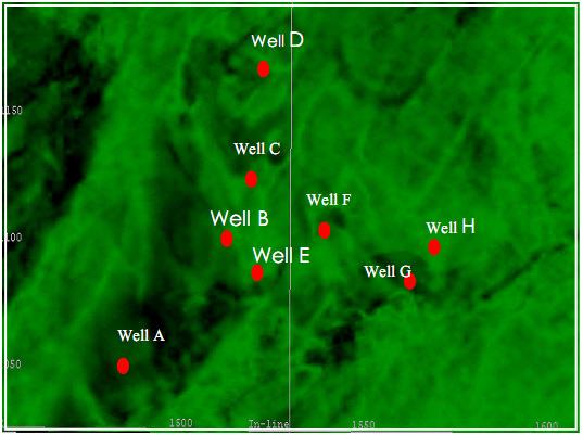
2 be viewed through animation to reveal spatial changes in stratigraphic thickness. The successive Spectral decomposition images reveal different parts of a reservoir with varying thickness in an area; Partyka et al, (1999 & 2003). In this paper Spectral Decomposition is being used for observing & discerning the response of the gas bearing channel sands to optimize the development plan in the study area. Geological Background Assam-Arakan basin is a polycyclic basin located in the North-Eastern part of India. The shelf part of the basin spreads over the Brahmaputra and Dhansiri valley, shelf to basinal slope part lies below the Naga Thrust and the basinal (geosynclinal) part is occupied by the Naga Schuppen belt and the Cachar-Tripura Mizoram-Manipur fold belts. This is a proven petroliferous basin covering about 116,000 sq km. About 7 kms thick sediments ranging in age from Paleocene to Recent are present in the shelf part and a huge thickness of more than 10 kms sediments ranging in age from Upper Cretaceous to Recent is present in the fold and thrust belt. Eocene-Pliocene sequences contain potential source, reservoir and cap rocks. Around 115 oil and gas fields have been discovered in the basin. The Upper Assam Shelf part is predominantly a Tertiary Basin. Sediments of Palaeocene/ Eocene age were deposited in shallow marine to marine environment in this basin. Regional tilt/uplift prompted widespread marine regressions with an increase in the supply of sediments to this part of the basin during Oligocene. This is reflected by predominance of deltaic facies in arenaceous sequence of Barail formations. On the other hand, argillaceous sequence of Barail Formation (Mainly of Lower Oligocene age), seem to belong to coastal plain (especially carbonaceous shales and coal). The upper sequence is embedded with a number of fluvial channel sands. During Miocene, sediments were deposited under fluvial and lacustrine environment. Study Area The study area is located in central part of OIL s operational area in Upper Assam Shelf Basin, at the southern bank of Brahmaputra River, in north-eastern part of India (Figure- 3). Figure-3: Location map showing study area along with well locations and line of cross section Acquisition & Processing Oil India has acquired approx. 500 sq.km. 3D- seismic data in and around the study area during & Before the acquisition of these surveys, several wells were drilled on the basis of 2D-seismic data interpretation in the area. The 3D surveys had primary objectives of detailed mapping of Paleocene/Eocene formation to identify additional drillable prospects, reasons for failure in some of the wells in the area. For the present study around 60 sq.km. 3D data was used. The data quality is good with a dominant frequency of about Hz and up to Hz present in the data. The processing flow consisted of the following steps input data & reformatting, trace editing, spherical divergence correction, refraction statics, surface consistent deconvolution, band pass filter, surface consistent amplitude scaling, velocity analysis, residual statics, PSTM, 3D stack. Interpretation (a) Reasons for taking up study As per the well log data, Within Oligocene sequence, Barail channel sands are fining upward sand bodies, deposited under fluvial condition. Initially, the channel sand bodies were considered to be continuous through out the structural extent in the study area. On basis of structural interpretation eight wells were drilled, out of which two wells (wells B & C) were on gas production in the sands pertaining to Barail formation of Oligocene sequence, four other wells (wells A, E, G & H) producing from a deeper 2
 these gas bearing sands are found to be structurally discontinuous and fining upwards, quite contrary to the initial structural interpretation.")

3 formation, showed evidence of hydrocarbons from well logs in the Barail sands, whereas two other wells i.e. well- D and well-f encountered shaley sands in this formation. As per the geological section (Figure 4) these gas bearing sands are found to be structurally discontinuous and fining upwards, quite contrary to the initial structural interpretation. All these challenges involved the use of some additional interpretational techniques; hence spectral decomposition along with other seismic attributes was extracted to delineate this geological anomaly charged with gas. Figure 4: Geological section through wells A, B, C and D showing fluvial channel sand in Barail Sequence (b) Method Initially mapping was done on two reflectors in this study; one on an unconformity surface between Miocene and Lower Oligocene which can be mapped regionally in the area and the other close to the producing sands (zone of interest). It may be noted that reflections between these two surfaces are not continuous (Figure 5). Well to seismic tie was established in all the well locations. Seismic attribute analyses viz. coherency, energy, instantaneous amplitude attribute were carried out within the two mapped horizons to supplement the geologic interpretation. Some channel like sand body anomaly was observed in coherency map (Figure 6), however, inspite of changing various parameters the sand body could not be mapped with confidence. Similar anomaly was also observed in energy as well as instantaneous amplitude attribute but with lot of uncertainty and the definition of channels was not very clear in these attribute maps (Figure 7) & (Figure 8) respectively. After limited success of conventional seismic attributes in discerning the possible channel like sand bodies, spectral decomposition analysis was taken up around the zone of interest i.e. close to the mapped horizon. The frequency slices were generated through a time window of ±12ms to ±36ms from mapped horizon, over a wide array of frequencies ranging from 8 Hz to 60 Hz. Animating through these frequencies, the best definition of the seismic anomaly was observed at 10Hz and 25Hz over a time window ±16ms. A number of channel bodies could be observed over the frequency range Hz (Figure 9a, 9b,9c & 9d), however, the best output of spectral decomposition anomaly was observed after blending of 10Hz and 25Hz extracted maps(figure 9e), because the thicker channel sand zones were tuned by lower frequencies and the thinner sand zones by higher frequencies. The interpreted possible channel is shown in Figure 9 (f). The width of fluvial channel is of the order of m. The mapped sand thickness also validates the observed best tuning frequency. Figure 5: Seismic section passing through the wells-d, C, B and E showing zone of interest 3


 at (c) Spectral decomposition")
4 Figure 6: Coherency map (±16ms volume) at mapped horizon close to reservoir Figure 9 (a) Spectral decomposition Images at 10Hz amplitude and Figure 7: Energy anomaly map (±16ms volume) at mapped horizon close to reservoir Figure 9 ( b) 25 Hz amplitude in ±16ms volume showing Paleofluvial channel at Barail sequence; showing outline of possible sand bodies. Figure 8: Amplitude anomaly map (±16ms volume) at mapped horizon close to reservoir Figure 9 (c) Spectral decomposition image at 40Hz and amplitude 4


5 (c) Results The observed channels were validated with well evidences. It was observed that the wells which intersect the channels encountered cleaner channel sands and therefore, were found to be productive. On the other hand, the other wells, drilled even just outside the channels encountered sands which were more shaly or very thin in nature and were not so productive. The results of the study are expected to be used to lower down the risk of continued development of reservoir and to support & locate additional prospects in the area. Figure 9 ( d) 50 Hz amplitude in ±16ms volume showing Paleofluvial channel at Barail sequence; very faint images of sand bodies, difficult to interpret Conclusion Spectral decomposition has become a useful and important technique & tool for extracting stratigraphic information from seismic data. In this paper, a case study is presented, where spectral decomposition is being used successfully to image & map the channel sands and established reasoning of success and failure of different wells in a study area in Upper Assam, India. Acknowledgements Authors thank Oil India Ltd. for giving permission for presenting the paper. Figure 9 (e) : Spectral decomposition image blended with 10Hz (green colour) and 25 Hz (red colour) in ±16ms volume showing Paleo-fluvial channel at Barail sequence References Partyka G., Gridley J. And Lopez J. : Interpretational applications of spectral decomposition in reservoir characterization. The Leading Edge, March 1999, Chopra S., Marfurt K.J.: Seismic Attributes for Prospect Identification and Reservoir Characterization, Geophysical Developments no. 11, Spectral decomposition and wavelet transform Ranga Rao A.: Geology and hydrocarbon potential of a part of Assam Arakan and its adjacent region. (1983) Petroleum Asia Journal. 6, Figure 9 (f) : Spectral decomposition image showing outline of possible fluvial channel sand bodies encountered in the wells Peyton L.., Bottjer R., Partyka G.: Interpretation of incised valleys using new 3-D seismic techniques: A case history using spectral decomposition and coherency. The Leading Edge, September 1998,
OIL INDIA LIMITED, GEOPHYSICS DEPARTMENT, DULIAJAN, ASSAM.
 J. P. Singh, M. K. Gupta & Akshaya Kumar, Oil India Limited, Duliajan. jpsingh@oilindia.in Summary Oil exploration in Upper Assam commenced with the discovery of the Digboi oilfield more than 100 years
Instantaneous Spectral Analysis Applied to Reservoir Imaging and Producibility Characterization
 Instantaneous Spectral Analysis Applied to Reservoir Imaging and Producibility Characterization Feng Shen 1* and Gary C. Robinson 1, Tao jiang 2 1 EP Tech, Centennial, CO, 80112, 2 PetroChina Oil Company,
Seismic Attributes and Their Applications in Seismic Geomorphology
 Academic article Seismic Attributes and Their Applications in Seismic Geomorphology Sanhasuk Koson, Piyaphong Chenrai* and Montri Choowong Department of Geology, Faculty of Science, Chulalongkorn University,
Multi-Component Seismic (3C) Data Acquisition A Case Study from Oil India Ltd. Operational Area in Upper Assam Basin*
 Data Acquisition A Case Study from Oil India Ltd. Operational Area in Upper Assam Basin*") Multi-Component Seismic (3C) Data Acquisition A Case Study from Oil India Ltd. Operational Area in Upper Assam Basin* K. L. Mandal 1, A. K. Khanna 1 and Dr. R. Dasgupta 1 Search and Discovery Article #40728
Multi-Component Seismic (3C) Data Acquisition A Case Study from Oil India Ltd. Operational Area in Upper Assam Basin* K. L. Mandal 1, A. K. Khanna 1 and Dr. R. Dasgupta 1 Search and Discovery Article #40728
Delineation of Reservoir Geometry of Thin TS-4 Sands using Seismic Inversion in Rudrasagar Field, Assam & Assam Arakan Basin
 Delineation of Reservoir Geometry of Thin TS-4 Sands using Seismic Inversion in Rudrasagar Field, Assam & Assam Naveen Poonia*, Abhradip Das, Md S Akhtar, Dr. A K Srivastava, C Mahapatra Oil & Natural
Feasibility and design study of a multicomponent seismic survey: Upper Assam Basin
 P-276 Summary Feasibility and design study of a multicomponent seismic survey: Upper Assam Basin K.L.Mandal*, R.K.Srivastava, S.Saha, Oil India Limited M.K.Sukla, Indian Institute of Technology, Kharagpur
Integrated Interpretation of Gravity, Magnetic & Seismic data for delineation of Basement Configuration in Sadiya Block, Upper Assam, India
 P-225 Integrated Interpretation of Gravity, Magnetic & Seismic data for delineation of Basement Summary G.K.Ghosh *, S.K.Basha, V.K. Kulshreshth Gravity and magnetic data were collected jointly by National
Application of Multi-Attributes and Spectral Decomposition with RGB blending for understanding the strati-structural features: A Case study
 10 th Biennial International Conference & Exposition P 262 Application of Multi-Attributes and Spectral Decomposition with RGB blending for understanding the strati-structural features: A Case study Summary
Pre Stack Imaging To Delineate A New Hydrocarbon Play A Case History
 5th Conference & Exposition on Petroleum Geophysics, Hyderabad-2004, India PP 375-379 Pre Stack Imaging To Delineate A New Hydrocarbon Play A Case History D. Srinivas, T.R. Murali Mohan, Ashwani Lamba,
3D Seismic Delineation of Thin Sandstone Reservoirs In Shalelimestone Rich Sequences Of Tapti-Daman Area: A Modelling Aided Approach
 5th Conference & Exposition on Petroleum Geophysics, Hyderabad-2004, India PP 423-430 3D Seismic Delineation of Thin Sandstone Reservoirs In Shalelimestone Rich Sequences Of Tapti-Daman Area: A Modelling
Fractured Volcanic Reservoir Characterization: A Case Study in the Deep Songliao Basin*
 Fractured Volcanic Reservoir Characterization: A Case Study in the Deep Songliao Basin* Desheng Sun 1, Ling Yun 1, Gao Jun 1, Xiaoyu Xi 1, and Jixiang Lin 1 Search and Discovery Article #10584 (2014) Posted
Reconstruction of Paleogeographic Setup of Tura Formation in Rudrasagar-Disangmukh-Panidihing Area of Upper Assam Shelf using 3-D Seismic techniques
 5th Conference & Exposition on Petroleum Geophysics, Hyderabad-2004, India PP 792-796 in Rudrasagar-Disangmukh-Panidihing Area of Upper Assam Shelf using 3-D Seismic techniques S.M.Ismail 1, R.N.Dwivedi
Seismic Inversion on 3D Data of Bassein Field, India
 5th Conference & Exposition on Petroleum Geophysics, Hyderabad-2004, India PP 526-532 Seismic Inversion on 3D Data of Bassein Field, India K.Sridhar, A.A.K.Sundaram, V.B.G.Tilak & Shyam Mohan Institute
Paleo History of a Deeper Level Tidal Lobe and its Facies Analysis : A Case Study
 Paleo History of a Deeper Level Tidal Lobe and its Facies Analysis : A Case Study V Chaganti*, T B Singh*, J K Bora*, Dr. Mahendra Pratap* Abstract Hydrocarbon exploitation is a play to exploit the Paleo
Southern Songkhla Basin, Gulf of Thailand
 Architecture and Depositional Environment of Fluvial Systems of Southern Songkhla Basin, Gulf of Thailand Toan Manh Do Petroleum Geoscience Program, Department of Geology, Faculty of Science, Chulalongkorn
EGAS. Ministry of Petroleum
 EGAS Ministry of Petroleum EGAS Ministry of Petroleum About The Block Location: N. Thekah offshore block is located at about 56 km to the north of the Mediterranean shore line, 85 km to the north west
APPENDIX C GEOLOGICAL CHANCE OF SUCCESS RYDER SCOTT COMPANY PETROLEUM CONSULTANTS
 APPENDIX C GEOLOGICAL CHANCE OF SUCCESS Page 2 The Geological Chance of Success is intended to evaluate the probability that a functioning petroleum system is in place for each prospective reservoir. The
P. S. Basak, Ravi Kant, K. Yasodha, T. Mukherjee, P. Rajanarayana, Sucheta Dotiwala, V. K. Baid, P.H. Rao, V. Vairavan, ONGC
 P-483 Summary Delineation of pinch-outs within Panna Formation of Paleocene-Early Eocene sequence in and around South Mumbai Low to Identify Prospective Areas - A Case Study P. S. Basak, Ravi Kant, K.
RELINQUISHMENT REPORT FOR LICENCE P.1663, BLOCK 29/4b and 29/5e
 RELINQUISHMENT REPORT FOR LICENCE P.1663, BLOCK 29/4b and 29/5e Licence: P.1663 Blocks: 29/4b & 29/5e 25th Round Traditional Licence Operator: Ithaca Energy UK(Ltd) 100% Work Programme Summary The agreed
EGAS. Ministry of Petroleum
 EGAS Ministry of Petroleum EGAS Ministry of Petroleum About The Block Location: N. El Arish offshore block is located in the extreme eastern part of the Egypt s economic water border and bounded from the
Bulletin of Earth Sciences of Thailand. Controls on Reservoir Geometry and Distribution, Tantawan Field, Gulf of Thailand.
 Controls on Reservoir Geometry and Distribution, Tantawan Field, Gulf of Thailand Atchara Praidee Petroleum Geoscience Program, Department of Geology, Faculty of Science, Chulalongkorn University, Bangkok
Interpretation of magnetic anomaly using cos( ) map and SED for automatic source edge location in Assam-Arakan basin of Mizoram state, India
 map and SED for automatic source edge location in Assam-Arakan basin of Mizoram state, India") Interpretation of magnetic anomaly using cos( ) map and SED for automatic source edge location in Assam-Arakan basin of Mizoram state, India G. K.Ghosh*, R. Dasgupta, A. N. Borthakur and S. N. Singh, Oil
Interpretation of magnetic anomaly using cos( ) map and SED for automatic source edge location in Assam-Arakan basin of Mizoram state, India G. K.Ghosh*, R. Dasgupta, A. N. Borthakur and S. N. Singh, Oil
Hydrocarbon Potential of the Marginal Fields in Niger Delta Oza Field, a case study*
 Hydrocarbon Potential of the Marginal Fields in Niger Delta Oza Field, a case study* J.N. Sahu 1, C.H.V. Satya Sai 1, V. Chintamani 1 and C. Vishnu Vardhan 1 Search and Discovery Article #20182 (2012)*
Bulletin of Earth Sciences of Thailand. Evaluation of the Petroleum Systems in the Lanta-Similan Area, Northern Pattani Basin, Gulf of Thailand
 Evaluation of the Petroleum Systems in the Lanta-Similan Area, Northern Pattani Basin, Gulf of Thailand Sirajum Munira Petroleum Geoscience Program, Department of Geology, Faculty of Science, Chulalongkorn
Kurt Marfurt Arnaud Huck THE ADVANCED SEISMIC ATTRIBUTES ANALYSIS
 The Society of Exploration Geophysicists and GeoNeurale announce Kurt Marfurt Arnaud Huck THE ADVANCED SEISMIC ATTRIBUTES ANALYSIS 3D Seismic Attributes for Prospect Identification and Reservoir Characterization
Deep-Water Reservoir Potential in Frontier Basins Offshore Namibia Using Broadband 3D Seismic
 Deep-Water Reservoir Potential in Frontier Basins Offshore Namibia Using Broadband 3D Seismic E. Polyaeva* (Petroleum Geo-Services), I. Thomas (Chariot Oil and Gas), C. Reiser (Petroleum Geo-Services),
Kurt Marfurt Arnaud Huck THE ADVANCED SEISMIC ATTRIBUTES ANALYSIS
 The Society of Exploration Geophysicists and GeoNeurale announce Kurt Marfurt Arnaud Huck THE ADVANCED SEISMIC ATTRIBUTES ANALYSIS 3D Seismic Attributes for Prospect Identification and Reservoir Characterization
Geochemical Exploration-Near Surface Expression of Hydrocarbon: A Case Study from Frontier Block of Assam-Arakan Basin
 P-284 Geochemical Exploration-Near Surface Expression of Hydrocarbon: A Case Study from Frontier Block of Assam-Arakan Basin Mithilesh Kumar*, V. K. Kulshreshtha, A.N. Borthakur, Oil India Limited; Shafique
Reprocessing strategy for shallower prospects from the available 3D data set Case history of Cambay Basin
 P-378 Reprocessing strategy for shallower prospects from the available 3D data set Case history of Cambay Basin M.Singh*, Vikash Chandra, USD Pandey Summary The occurrence of non commercial hydrocarbons
Integrated well log and 3-D seismic data interpretation for the Kakinada area of KG PG offshore basin
 IOSR Journal of Applied Geology and Geophysics (IOSR-JAGG) e-issn: 2321 0990, p-issn: 2321 0982.Volume 5, Issue 4 Ver. II (Jul. Aug. 2017), PP 01-05 www.iosrjournals.org Integrated well log and 3-D seismic
Comparative Study of AVO attributes for Reservoir Facies Discrimination and Porosity Prediction
 5th Conference & Exposition on Petroleum Geophysics, Hyderabad-004, India PP 498-50 Comparative Study of AVO attributes for Reservoir Facies Discrimination and Porosity Prediction Y. Hanumantha Rao & A.K.
Oil and Natural Gas Corporation Ltd., VRC(Panvel), WOB, ONGC, Mumbai. 1
, WOB, ONGC, Mumbai. 1") P-259 Summary Data for identification of Porosity Behaviour in Oligocene Lime Stone of D18 Area Of Western Offshore, India V.K. Baid*, P.H. Rao, P.S. Basak, Ravi Kant, V. Vairavan 1, K.M. Sundaram 1, ONGC
P-259 Summary Data for identification of Porosity Behaviour in Oligocene Lime Stone of D18 Area Of Western Offshore, India V.K. Baid*, P.H. Rao, P.S. Basak, Ravi Kant, V. Vairavan 1, K.M. Sundaram 1, ONGC
Seismic Spectral Attributes using Coherence and Semblance Algorithms
 Vol.5, No.9, 214 Seismic Spectral Attributes using Coherence and Semblance Algorithms Williams Ofuyah 1* Olatunbosun Alao 2 Victor Olaseni 3 Lukman Adeoti 4 1.Department of Earth Sciences, Federal University
Seismic Imaging using Attribute Analysis for Identifying Stratigraphic Plays in CA-C25/ TP Area, Tapti Daman Sector, Mumbai Offshore
 5th Conference & Exposition on Petroleum Geophysics, Hyderabad-2004, India PP 473-477 Seismic Imaging using Attribute Analysis for Identifying Stratigraphic Plays in CA-C25/ TP Area, Tapti Daman Sector,
Paleogene low stand deepwater canyon fill deposits in Mahanadi Offshore Basin: can it prove to be the elusive major hydrocarbon discovery?
 P-317 Paleogene low stand deepwater canyon fill deposits in Mahanadi Offshore Basin: can it prove to be the elusive major Summary *Pradipta Kumar Das & Sudipto Datta, ONGC Mahanadi Deepwater Offshore Basin
DHI Analysis Using Seismic Frequency Attribute On Field-AN Niger Delta, Nigeria
 IOSR Journal of Applied Geology and Geophysics (IOSR-JAGG) e-issn: 2321 0990, p-issn: 2321 0982.Volume 1, Issue 1 (May. Jun. 2013), PP 05-10 DHI Analysis Using Seismic Frequency Attribute On Field-AN Niger
Sedimentary Cycle Best Practice: Potential Eo-Oligocene Sediments in Western Indonesia*
 Sedimentary Cycle Best Practice: Potential Eo-Oligocene Sediments in Western Indonesia* Mellinda Arisandy 1 and I Wayan Darma 1 Search and Discovery Article #11008 (2017)** Posted November 6, 2017 *Adapted
OIL SHALE OCCURRENCES IN UPPER ASSAM BASIN, INDIA : AN OVERVIEW
 OIL SHALE OCCURRENCES IN UPPER ASSAM BASIN, INDIA : AN OVERVIEW V.K.Sibal Srinivasan V.Raju Directorate General of Hydrocarbons New Delhi SEDIMENTARY BASIN MAP OF INDIA 2 HYDROCARBON RESOURCE BASE Sedimentary
FUNDAMENTALS OF SEISMIC EXPLORATION FOR HYDROCARBON
 FUNDAMENTALS OF SEISMIC EXPLORATION FOR HYDROCARBON Instructor : Kumar Ramachandran 10 14 July 2017 Jakarta The course is aimed at teaching the physical concepts involved in the application of seismic
Application of High Resolution Seismic Survey in CBM Exploration A Case study, Sohagpur West Block, Madhya Pradesh
 P - 421 Application of High Resolution Seismic Survey in CBM Exploration A Case study, Sohagpur West Block, Madhya Pradesh T. Seshunarayana, D.Viswaja*, K.N.S.S.S. Srinivas, P. Srinivasa Rao, S. Trupti,
PETROLEUM GEOSCIENCES GEOLOGY OR GEOPHYSICS MAJOR
 PETROLEUM GEOSCIENCES GEOLOGY OR GEOPHYSICS MAJOR APPLIED GRADUATE STUDIES Geology Geophysics GEO1 Introduction to the petroleum geosciences GEO2 Seismic methods GEO3 Multi-scale geological analysis GEO4
Thin-Bed Reflectivity An Aid to Seismic Interpretation
 Thin-Bed Reflectivity An Aid to Seismic Interpretation Satinder Chopra* Arcis Corporation, Calgary, AB schopra@arcis.com John Castagna University of Houston, Houston, TX, United States and Yong Xu Arcis
Combined Seismic Multiple Attribute Analysis: An effective tool for lightly explored basins
 P-345 Combined Seismic Multiple Attribute Analysis: An effective tool for lightly explored basins Shubhabrata Samantaray* and Pankaj Gupta. Reliance Industries Ltd, Petroleum Business (E&P) Summary Search
Acquiring Better Seismic Data in Virgin Area through Model Studies and Field Experimentation: A Case Study from Cachar Belt of Assam
 5th Conference & Exposition on Petroleum Geophysics, Hyderabad-2004, India PP 273-279 Acquiring Better Seismic Data in Virgin Area through Model Studies and Field Experimentation: A Case Study from Cachar
Keywords. Spectral Decomposition, Continuous Wavelet Transform, Tuning Frequency
 Spectral decomposition for recognition of subtle depositional elements in deepwater fans: A case study from Krishna Godavari Basin, India Umang Sundriyal*, Anand S. Kale, Arati Srivastava, Shiv Kumar Malasi,
The Application of Data Conditioning, Frequency Decomposition, and RGB Colour Blending in the Gohta Discovery (Barents Sea, Norway)*
*") Click to View Slides The Application of Data Conditioning, Frequency Decomposition, and RGB Colour Blending in the Gohta Discovery (Barents Sea, Norway)* Syed Fakhar Gilani 1, and Luis Gomez 2, and Ryan
Click to View Slides The Application of Data Conditioning, Frequency Decomposition, and RGB Colour Blending in the Gohta Discovery (Barents Sea, Norway)* Syed Fakhar Gilani 1, and Luis Gomez 2, and Ryan
THE USE OF SEISMIC ATTRIBUTES AND SPECTRAL DECOMPOSITION TO SUPPORT THE DRILLING PLAN OF THE URACOA-BOMBAL FIELDS
 THE USE OF SEISMIC ATTRIBUTES AND SPECTRAL DECOMPOSITION TO SUPPORT THE DRILLING PLAN OF THE URACOA-BOMBAL FIELDS Cuesta, Julián* 1, Pérez, Richard 1 ; Hernández, Freddy 1 ; Carrasquel, Williams 1 ; Cabrera,
Continuous Wavelet Transform Based Spectral Decomposition of 3d Seismic Data for Reservoir Characterization in Oyi Field, se Niger Delta
 American Journal of Applied Sciences Original Research Paper Continuous Wavelet Transform Based Spectral Decomposition of 3d Seismic Data for Reservoir Characterization in Oyi Field, se Niger Delta Chukwuemeka
Airborne gravity gradiometer surveying of petroleum systems under Lake Tanganyika, Tanzania
 Airborne gravity gradiometer surveying of petroleum systems under Lake Tanganyika, Tanzania D. Roberts Beach Energy P. Roy Chowdhury CGG S. J. Lowe CGG A. N. Christensen CGG Outline Introduction Geology
DATA ANALYSIS AND INTERPRETATION
 III. DATA ANALYSIS AND INTERPRETATION 3.1. Rift Geometry Identification Based on recent analysis of modern and ancient rifts, many previous workers concluded that the basic structural unit of continental
REGIONAL GEOLOGY IN KHMER BASIN
 CONTENTS 1-Khmere Basin 2-Regional Geology Khmer Basin 3-Regime Tectonic 4-Seismic Database -a/ Acquisition Data -b/ Prospect Angkor -C/ Cross Section Seismic 5-Play Type -a/ Play Schematic -b/ Structure
Wavelet analysis identifies geology in seismic
 Wavelet analysis identifies geology in seismic Geologic lithofacies can be quantitatively identified by the wavelet decomposition of the seismic reflection. That is, the reservoir risk can be mitigated
Stratigraphic Plays in Active Margin Basin: Fluvio-Deltaic Reservoir Distribution in Ciputat Half Graben, Northwest Java Basin*
 Stratigraphic Plays in Active Margin Basin: Fluvio-Deltaic Reservoir Distribution in Ciputat Half Graben, Northwest Java Basin* Ary Wahyu Wibowo 1, Astri Pujianto 1, Wisnu Hindadari 1, Arief Wahidin Soedjono
The SPE Foundation through member donations and a contribution from Offshore Europe
 Primary funding is provided by The SPE Foundation through member donations and a contribution from Offshore Europe The Society is grateful to those companies that allow their professionals to serve as
Improving Resolution with Spectral Balancing- A Case study
 P-299 Improving Resolution with Spectral Balancing- A Case study M Fatima, Lavendra Kumar, RK Bhattacharjee, PH Rao, DP Sinha Western Offshore Basin, ONGC, Panvel, Mumbai Summary: The resolution limit
Multiple horizons mapping: A better approach for maximizing the value of seismic data
 Multiple horizons mapping: A better approach for maximizing the value of seismic data Das Ujjal Kumar *, SG(S) ONGC Ltd., New Delhi, Deputed in Ministry of Petroleum and Natural Gas, Govt. of India Email:
Seismic Expressions of Submarine Channel - Levee Systems and Their Architectural Elements
 Seismic Expressions of Submarine Channel - Levee Systems and Their Architectural Elements Summary D.V. Ramana, Santanu De* and Kalyanbrata Datta KDMIPE, ONGC, Dehradun E-mail- devvenram@rediffmail.com
STRUCTURAL INTERPRETATION AND HYDROCARBON POTENTIAL OF OBUA FIELD, NIGER DELTA, SOUTHERN NIGERIA
 STRUCTURAL INTERPRETATION AND HYDROCARBON POTENTIAL OF OBUA FIELD, NIGER DELTA, SOUTHERN NIGERIA 1 Iwuoma Juliet Onyinyechukwu and 2 Minapuye I. Odigi 1 Department of Geology, University of Port Harcourt,
Multi-Spectral Coherence
 Multi-Spectral Coherence Fangyu Li, Jie Qi, Bin Lyu, and Kurt J. Marfurt ConocoPhillips School of Geology and Geophysics University of Oklahoma, Norman, OK. fangyu.li@ou.edu, jie.qi@ou.edu, bin.lyu@ou.edu,
Meandering Miocene Deep Sea Channel Systems Offshore Congo, West Africa
 Meandering Miocene Deep Sea Channel Systems Offshore Congo, West Africa S. Baer* (PGS), J. E. Comstock (PGS), K. Vrålstad (PGS), R. Borsato (PGS), M. Martin (PGS), J.P. Saba (SNPC), B. Débi-Obambé (SNPC)
Block 43B - Onshore Oman
 Block 43B - Onshore Oman SUMMARY Block 43B is an 11,967 km 2 area located along the coastal area of Oman north of the Hajar Mountains. This is an unexplored region, both geographically and stratigraphically.
Relinquishment Report. Licence P2016 Block 205/4c
 Relinquishment Report Licence P2016 Block 205/4c September 2016 JX Nippon Exploration and Production (U.K.) Limited Idemitsu Petroleum UK Ltd. Table of Contents 1. Licence Information... 1 2. Licence Synopsis...
Lithology prediction and fluid discrimination in Block A6 offshore Myanmar
 10 th Biennial International Conference & Exposition P 141 Lithology prediction and fluid discrimination in Block A6 offshore Myanmar Hanumantha Rao. Y *, Loic Michel, Hampson-Russell, Kyaw Myint, Ko Ko,
A Petroleum Geologist's Guide to Seismic Reflection
 A Petroleum Geologist's Guide to Seismic Reflection William Ashcroft WILEY-BLACKWELL A John Wiley & Sons, Ltd., Publication Contents Preface Acknowledgements xi xiii Part I Basic topics and 2D interpretation
Improving Surface Seismic Resolution using VSP Data
 P-115 Improving Surface Seismic Resolution using VSP Data M. Bhanu*, J. Saikia, O. P. Singh & K. V. Krishnan, ONGC, India. Summary Bore hole seismic preserves higher bandwidth than surface seismic data.
Seismic Data Acquisition In Complex Boulder Bed Area: A Case Study In Arunachal Pradesh, North East INDIA
 P-206 Seismic Data Acquisition In Complex Boulder Bed Area: A Case Study In Arunachal Pradesh, North East INDIA Summary G.K.Ghosh*, D. N. Saroj, A.K.Khanna and R. Das gupta, Oil India Limited The area
BALOCHISTAN FOLDBELT BASIN
 INTRODUCTION BALOCHISTAN FOLDBELT BASIN The Kharan-3 block is located in the Kharan Trough of Balochistan Basin. GEOLOGICAL SETTING The Balochistan Province is an Upper Cretaceous to Recent structurally
INTEG, GEOPIC, ONGC, Dehradun 11th Biennial International Conference & Exposition
 Seismic facies classification and RGB blending as tools for prospect generation: A Case Study Mrinmoy Sharma*, S.K.Sharma, G.V.Suresh, PK Chaudhuri GEOPIC, ONGC, Dehradun, Uttarakhand, India Keywords Seismic
SouthWest Energy (HK) Ltd.
 Ltd.") SouthWest Energy (HK) Ltd. Investor Presentation Cape Town October 2012 Why Are We Searching Oil in SWE Blocks? Similar geological g setting with Yemen s producing fields Oil seeps and oil show in the
SouthWest Energy (HK) Ltd. Investor Presentation Cape Town October 2012 Why Are We Searching Oil in SWE Blocks? Similar geological g setting with Yemen s producing fields Oil seeps and oil show in the
Facies Classification Based on Seismic waveform -A case study from Mumbai High North
 5th Conference & Exposition on Petroleum Geophysics, Hyderabad-2004, India PP 456-462 Facies Classification Based on Seismic waveform -A case study from Mumbai High North V. B. Singh, D. Subrahmanyam,
Uncertainties in Hydrocarbon Exploration in Deepwater areas: a few case studies
 10 th Biennial International Conference & Exposition P 113 Summary Uncertainties in Hydrocarbon Exploration in Deepwater areas: a few case studies C.Samajdar* & R.Kumar The era of easy to find hydrocarbon
MUHAMMAD S TAMANNAI, DOUGLAS WINSTONE, IAN DEIGHTON & PETER CONN, TGS Nopec Geological Products and Services, London, United Kingdom
 Geological and Geophysical Evaluation of Offshore Morondava Frontier Basin based on Satellite Gravity, Well and regional 2D Seismic Data Interpretation MUHAMMAD S TAMANNAI, DOUGLAS WINSTONE, IAN DEIGHTON
Objective Oriented Reprocessing of 3D data - A Case Study of Cambay Basin
 10 th Biennial International Conference & Exposition P 223 Objective Oriented Reprocessing of 3D data - A Case Study of Cambay Basin Viswaja Devalla* S.K.Choudhary and M.S.Rawat Summary The 3D seismic
Blocks 31, 32, 33, 34, 35 & 36/03 Southeast Offshore Vietnam
 Blocks 31, 32, 33, 34, 35 & 36/03 Southeast Offshore Vietnam Block 31 32 33 34 35 36/03 Area (km 2) 5,036 4,440 4,630 4,700 4,630 2,950 Sea level (m) 20 20-30 30-40 50 50 50 Seismic 2D (km) 1,294 685 431
Improved image aids interpretation: A case history
 Ye Zheng, Scott Cheadle (Veritas GeoServices, Calgary, Canada) Glenn M. Rising (Perez Companc Norcen Corod, Venezuela) SUMMARY The Oritupano-Leona 3D of Eastern Venezuela was originally acquired and processed
Use of Traveltime Tomographic velocity model beyond imaging: Estimating 3D pore pressure & effective stress volumes
 10 th Biennial International Conference & Exposition P 324 Summary Use of Traveltime Tomographic velocity model beyond imaging: Estimating 3D pore pressure & effective stress volumes Kanharol K Hari*,
Applications of texture attribute analysis to 3D seismic data
 INTERPRETER S CORNER Coordinated by Rebecca B. Latimer Applications of texture attribute analysis to 3D seismic data SATINDER CHOPRA and VLADIMIR ALEXEEV, Arcis Corporation, Calgary, Alberta, Canada In
Simultaneous Inversion of Clastic Zubair Reservoir: Case Study from Sabiriyah Field, North Kuwait
 Simultaneous Inversion of Clastic Zubair Reservoir: Case Study from Sabiriyah Field, North Kuwait Osman Khaled, Yousef Al-Zuabi, Hameed Shereef Summary The zone under study is Zubair formation of Cretaceous
3D Converted Wave Data Processing A case history
 P-290 3D Converted Wave Data Processing A case history N. B. R. Prasad, ONGC Summary In recent years, there has been a growing interest in shear- wave exploration for hydrocarbons as it facilitates to
Enhancement of seismic data quality and interpretation for mapping base Zubair sands of Southeast Kuwait
 Enhancement of seismic data quality and interpretation for mapping base Zubair sands of Southeast Kuwait Rajive Kumar *, Karam, M. Hafez, Anandan Mudavakkat, Aisha Y. Al-Ghareeb, Thekriat Hussain, Ritesh
Residual Moveout Correction; its impact on PSTM Processed data: A Case Study
 P - 130 Residual Moveout Correction; its impact on PSTM Processed data: A Case Study Anand Prakash*, S.K.Bora, Anil Kumar, Regional Computer Centre,P-32 Transport Deport Road, Kolkata 700088 a_prakash999@hotmail.com
Fluid contacts and net-pay identification in three phase reservoirs using seismic data
 Fluid contacts and net-pay identification in three phase reservoirs using seismic data José Gil*; Fusion Petroleum Technologies, Richard Pérez; Julian Cuesta; Rosa Altamar, María Sanabria; Petrodelta.
Principal Components Analysis of Spectral Components. (Principal Components Analysis) Hao Guo, Kurt J. Marfurt* and Jianlei Liu
 Hao Guo, Kurt J. Marfurt* and Jianlei Liu") Principal Components Analysis of Spectral Components (Principal Components Analysis) Hao Guo, Kurt J. Marfurt* and Jianlei Liu Hao Guo Allied Geophysical Laboratories, University of Houston hguo2@uh.edu
Principal Components Analysis of Spectral Components (Principal Components Analysis) Hao Guo, Kurt J. Marfurt* and Jianlei Liu Hao Guo Allied Geophysical Laboratories, University of Houston hguo2@uh.edu
3D Seismic Reservoir Characterization and Delineation in Carbonate Reservoir*
 3D Seismic Reservoir Characterization and Delineation in Carbonate Reservoir* M. N. Alamsyah 1, Bambang W. Handono 1, and Andri Syafriya 1 Search and Discovery Article #41760 (2016) Posted January 25,
Churning seismic attributes with principal component analysis
 Satinder Chopra + * and Kurt J. Marfurt + Arcis Seismic Solutions, Calgary; The University of Oklahoma, Norman Summary Seismic attributes are an invaluable aid in the interpretation of seismic data. Different
Relinquishment Report. for. Licences: P.1596 (Blocks 205/3, 205/4a) P.1836 (Block 205/2b) P.1837 (Block 205/5b)
 P.1836 (Block 205/2b) P.1837 (Block 205/5b)") Relinquishment Report for Licences: P.1596 (Blocks 205/3, 205/4a) P.1836 (Block 205/2b) P.1837 (Block 205/5b) November 2013 1 of 9 CONTENT 1. Header 2. Synopsis 3. Exploration Activities 4. Prospectivity
Relinquishment Report for Licences: P.1596 (Blocks 205/3, 205/4a) P.1836 (Block 205/2b) P.1837 (Block 205/5b) November 2013 1 of 9 CONTENT 1. Header 2. Synopsis 3. Exploration Activities 4. Prospectivity
Shallow Gas Prospect Evaluation in Shahbazpur Structure Using Seismic Attributes Analysis - a Case Study for Bhola Island, Southern Bangladesh
 Dhaka Univ. J. Sci. 64(2): 135-140, 2016 (July) Shallow Gas Prospect Evaluation in Shahbazpur Structure Using Seismic Attributes Analysis - a Case Study for Bhola Island, Southern Bangladesh Morshedur
Controls on clastic systems in the Angoche basin, Mozambique: tectonics, contourites and petroleum systems
 P2-2-13 Controls on clastic systems in the Angoche basin, Mozambique: tectonics, contourites and petroleum systems Eva Hollebeek, Olivia Osicki, Duplo Kornpihl Schlumberger, London, UK Introduction Offshore
Seismic attributes for fault/fracture characterization
 Satinder Chopra* and Kurt J. Marfurt + *Arcis Corporation, Calgary; + University of Houston, Houston Summary Seismic attributes have proliferated in the last three decades at a rapid rate and have helped
NXT Energy Solutions Inc.
 SFD Case Example:, Western Canada (Stratigraphic Trapping) Lower Cretaceous Fluvial channel system of the Mannville Group is one of the most prolific hydrocarbon bearing strata in the province of Alberta.
Geosciences Career Pathways (Including Alternative Energy)
") Geosciences Career Pathways (Including Alternative Energy) Shale Carbonates Clastics Unconventionals Geology Characterization and Production Properties of Gas Shales Geomechanics in International Shale
Geosciences Career Pathways (Including Alternative Energy) Shale Carbonates Clastics Unconventionals Geology Characterization and Production Properties of Gas Shales Geomechanics in International Shale
Colombia s Offshore*
 PS A Seismic-Structural Interpretation, on the Identification of Possible Causes in the Formation of Gas Chimneys in Colombia s Offshore* Tatiana Mayorga 1, Andrés E. Calle 2, Freddy M. Niño 2, Jorge Rubiano
Bulletin of Earth Sciences of Thailand
 Quantitative Seismic Geomorphology of Early Miocene to Pleistocene Fluvial System of Northern Songkhla Basin, Gulf of Thailand Oanh Thi Tran Petroleum Geoscience Program, Department of Geology, Faculty
ANGOLA OFFSHORE LICENSING 2007 BLOCK 46
 AGOLA OFFHOR LICIG 2007 BLOCK 46 DATA BA AVAILABILITY Figure 1 shows the seismic data available on Block 46. Fig. 1 Commercial 2D surveys: esterngeco: 794 km. GX Technology: 116 km. Commercial 3D surveys:
23855 Rock Physics Constraints on Seismic Inversion
 23855 Rock Physics Constraints on Seismic Inversion M. Sams* (Ikon Science Ltd) & D. Saussus (Ikon Science) SUMMARY Seismic data are bandlimited, offset limited and noisy. Consequently interpretation of
Petroleum geology framework, West Coast offshore region
 Petroleum geology framework, West Coast offshore region James W. Haggart* Geological Survey of Canada, Vancouver, BC jhaggart@nrcan.gc.ca James R. Dietrich Geological Survey of Canada, Calgary, AB and
Improved Interpretability via Dual-sensor Towed Streamer 3D Seismic - A Case Study from East China Sea
 Improved Interpretability via Dual-sensor Towed Streamer 3D Seismic - A Case Study from East China Sea S. Rongfu (CNOOC Shanghai), C. Hua (CNOOC Shanghai), W. Yun (CNOOC Shanghai), Z. Yabin (CNOOC Shanghai),
Arnab Nag*, Divya Prakash Singh, Anshika Agarwal, Shiv Kumar Malasi, Anand S. Kale BPRL, Mumbai
 Application of Seismic Facies Classification, Spectral Decomposition and Seismic Attributes to characterize deep-water depositional facies in Oligocene sequence of KG Basin, India Arnab Nag*, Divya Prakash
Time-frequency analysis of seismic data using synchrosqueezing wavelet transform a
 Time-frequency analysis of seismic data using synchrosqueezing wavelet transform a a Published in Journal of Seismic Exploration, 23, no. 4, 303-312, (2014) Yangkang Chen, Tingting Liu, Xiaohong Chen,
POTENTIAL STRATIGRAPHIC PLAY IN THE WESTERN HA LONG BASIN FROM 3D SEISMIC INVERSION AND REGIONAL GEOLOGICAL CONTEXT
 PETROLEUM EXPLORATION & PRODUCTION POTENTIAL STRATIGRAPHIC PLAY IN THE WESTERN HA LONG BASIN FROM 3D SEISMIC INVERSION AND REGIONAL GEOLOGICAL CONTEXT Nguyen Du Hung 1, Hoang Viet Bach 1, Ngo Van Quan