Apache Egypt Companies. The introduction of 3D seismic techniques three decades ago greatly enhanced our
|
|
|
- Camilla Dorsey
- 6 years ago
- Views:
Transcription
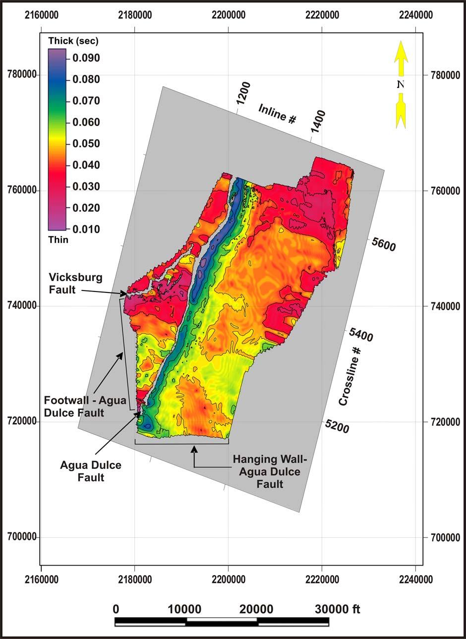
1 Structure architecture interpretation of the middle Frio Formation using 3D seismic attributes and well logs: an example from the Texas Gulf Coast of the United States HAMED EL-MOWAFY 1 and KURT J. MARFURT 2 1 Department of Geology, Al-Azhar University, Cairo, Egypt; Consultant Geoscientist, Apache Egypt Companies. hamed.elmowafy@egy.apachecorp.com 2 ConocoPhillips School of Geology and Geophysics, University of Oklahoma. The introduction of 3D seismic techniques three decades ago greatly enhanced our ability to image complex subsurface structure and stratigraphy in petroleum provinces around the world. 3D seismic provides an efficient tool in the recognition and recovery of reserves in both the new and mature oil fields (Nestvold, 1996). 3D seismic helps reduce dry-hole risk resulting in better well placement. 3D seismic can also add reserves in mature producing fields such as Stratton and Agua Dulce fields in the Texas Gulf Coast of the United States. While the success of 3D seismic data as an exploration and development tool has been demonstrated many times, it is important to continue documenting this success in different geologic terranes. Therefore, the objective of this work is to show how 3D seismic data acquired in the Texas Gulf Coast sedimentary basin results in better subsurface structural images that were impossible to fully interpret from 2D seismic data and well logs. Integrated approaches that use high quality data sets have a great promise for better reservoir development and exploitation especially in mature fields such as Stratton and Agua Dulce in south Texas. In the Stratton and Agua Dulce field area (Figure 1), two 3D seismic surveys resulted in imaging previously undefined small-scale faults at the middle Frio level that may have resulted in more reservoir compartmentalization. Previous analysis of well logs and 2D seismic sections in the Wardner lease of Stratton field indicate that faults die out at the lower Frio stratigraphic level and rarely extend upward into the middle Frio; the amount 1
2 of fault throw is usually small and fault block rotation is minimal (Levey et al., 1993, Figure 2). We will use our 3D seismic surveys to validate this earlier interpretation. The Oligocene middle Frio Formation is a major hydrocarbon producer in the Gulf Coast of the United States. At Stratton field, the middle Frio Formation consists of multiple vertically-stacked reservoir sequences. The target stratigraphic interval for investigation is the basal part of the middle Frio Formation (BMF) interval between the G2 (top lower Frio) and the F11 horizons (Figure 3). The structural setting of the middle Frio Formation in the study area is represented by growth faults and associated rollover anticlines. The complex internal architecture of the middle Frio fluvial reservoirs along with the structure complexity caused by growth faults may result in bypassed reservoirs or compartments that have potential reserve growth. Previous studies by Levey, et al.(1993) showed that untapped and incompletely drained reserves were encountered in the middle Frio reservoirs. Such results inspire the use of 3D seismic to search for additional by-passed gas resources in the BMF interval in the Stratton field area. We used two post-stack final-time-migration 3D seismic surveys to develop a detailed structure architecture interpretation of the middle Frio (Figure 1). The first survey is a 90 mi 2 (235 km 2 ) 3D data set provided by Anadarko Petroleum Corporation which was original shot in 1993 by Union Pacific Resources (UPR) Company and processed by Western Geophysical. The second is a 7.6 mi 2 (20 km 2 ) public domain 3D seismic survey acquired in 1992 by the State of Texas Bureau of Economic Geology (BEG) at the University of Texas at Austin and processed by Mercury International Technology Company in Tulsa, Oklahoma. This latter public domain survey is readily accessible through the BEG and has been the subject of dozens of published geophysics and geology papers. It is our hope that by presenting this smaller BEG survey in the context of the larger UPR survey, that we might inspire others to further refine the interpretation of the smaller BEG survey. 2
3 INTERPRETATION OF THE MIDDLE FRIO STRUCTURE ARCHITECTURE We used the vertical seismic profile (VSP) (Figure 4) acquired by the BEG at the Wardner 175 well in Stratton field to directly tie the seismic data to the geologic horizons. The Wardner 175 well with the VSP lies in the heart of the BEG survey and on the southern border of the UPR survey. The two 3D seismic surveys (BEG and UPR) used in the interpretation partially overlap in the northern Stratton field area (Figure 1). Major and Subsidiary Faults: Syndepositional or Post-Depositional? The geological cross section (Figure 5a) illustrates the change in thickness of the interval between the marker top E41 horizon (MTE41) and the marker top lower Frio horizon (G2) in both the hanging wall and footwall sides of the Agua Dulce (AD) fault. Note the change in thickness of the BMF interval in the hanging wall side at different locations relative to the AD fault. The coincident arbitrary seismic line (Figure 5b) also illustrates that the AD fault has significant control over total thickness variation at different locations with respect to the fault. Our BMF isochron maps indicate a thick sediment section that was deposited in a time when structurally low areas provided greater accommodation space. The thin sediment section was deposited in a time when structurally high areas resulted in little to no deposition of sediments corresponding to significantly smaller accommodation space. The F11-F39 vertical section (Figure 5) and isochron map (Figure 6) generated using both seismic and well log data show thickening between reflectors on the hanging wall side of the AD fault, suggesting that the fault was syndepositional. To test whether or not the synthetic and antithetic faults associated with the major growth faults were active during deposition we constructed two geological cross sections along with the coincident arbitrary seismic lines (Figures 7 and 8). Correlating the middle 3
4 Frio horizons (Figure 7a) indicates that the gross thickness of the interval between the marker top E41 horizon (MTE41) and the marker base F39 horizon (MBF39) is thicker by 126 ft (38 m) in the hanging wall of the antithetic fault than in the footwall block. In Figure 8a the gross thickness of the interval between the top F11 and the base F39 in well Gruene 9 in the hanging wall block of the synthetic fault B is 44 ft (13 m) thicker than the same interval in well Gruene 21 located in the footwall block. These two examples indicate that the synthetic and antithetic faults associated with the major AD growth fault are not just accommodation faults but they are syndepositional faults that cut through the BMF interval (the interval between G2 and F11). Further investigation is needed to determine if these secondary faults are conduits or seals to the migrating hydrocarbons in the Stratton and Agua Dulce fields. The middle Frio Formation is composed of fluvial deposits in the form of point bar and crevasse splay sandstones isolated within floodplain mudstones and siltstones. This heterogeneity makes it possible that even a small amount of vertical fault offsets will juxtapose low-permeability floodplain deposits against permeable sandstone reservoir rocks. Therefore, small vertical offsets along these faults may form lateral flow barriers. Another way in which these synthetic and antithetic faults may compartmentalize the middle Frio reservoirs is by providing seals which follow the fault as gouge or cemented breccias which formed along fault planes due to mechanical breakdown of rock during fault movement. Therefore the secondary faults interpreted from the 3D seismic data sets (Figures 5-8) may impact the lateral continuity and result in more compartmentalization of the middle Frio meandering fluvial sandstone reservoirs. Coupled with an appropriate depositional model, mapping the structural and stratigraphic complexity with the aid of the 3D seismic data of the BMF interval can help better image and develop fluvial reservoirs in the Stratton and Agua Dulce fields area and in the Texas Gulf Coast at large. 4
5 Structure framework. While the previously constructed structure maps on top of shallower middle Frio horizons -- based on well data only -- clearly showed the AD fault, the more subtle synthetic and antithetic faults were not recognized. Figure 9 is a structure contour map showing Yang s (1998) structure configuration of the F11 horizon in Stratton field. Other than the major AD fault, there is only one minor fault mapped in the southeast corner of the map. Figure 10 is a two-way time structure map constructed for the same F11 horizon in the Stratton and Agua Dulce fields area from the BEG and the UPR 3D seismic surveys. This map shows two major faults bounding the western side of the image area and several subtle faults that were not shown before, at the F11 stratigraphic level and scattered at different parts of the rollover anticlinal structure in the hanging wall side of the AD fault. Figure 11 is a 3D view of the F11 horizon mapped from the BEG 3D seismic survey. Note that the surface irregularities in the rollover anticline reflect the locations of subtle faults in the hanging wall of the AD fault. At the deeper horizons of the middle Frio Formation (such as the F39 horizon shown in Figures 7b and 8b) the hanging wall deformation is more pronounced than at shallower horizons. Based on seismic data only, the structure of the F39 horizon exhibits rollover amplitudes (structural closures) that range from 150 ft (46 m) to 700 ft (213 m). At the shallower F11 stratigraphic level, the rollover amplitudes decrease and range from 50 ft (15 m) to 500 ft (152 m). Nature of the growth faults. 3D seismic data volumes provide detailed information on the imaged subsurface rock volume. In the vertical sections it gives the best view of structure style and picking of events across the faults. In the horizontal sections it aids in accurate delineation of fault blocks and thus results in accurate well placement. As shown from the previous maps and cross sections (Figures 5-11), the major growth faults affect the BMF interval and younger sediments. The nature of the subsidiary synthetic and antithetic faults is 5
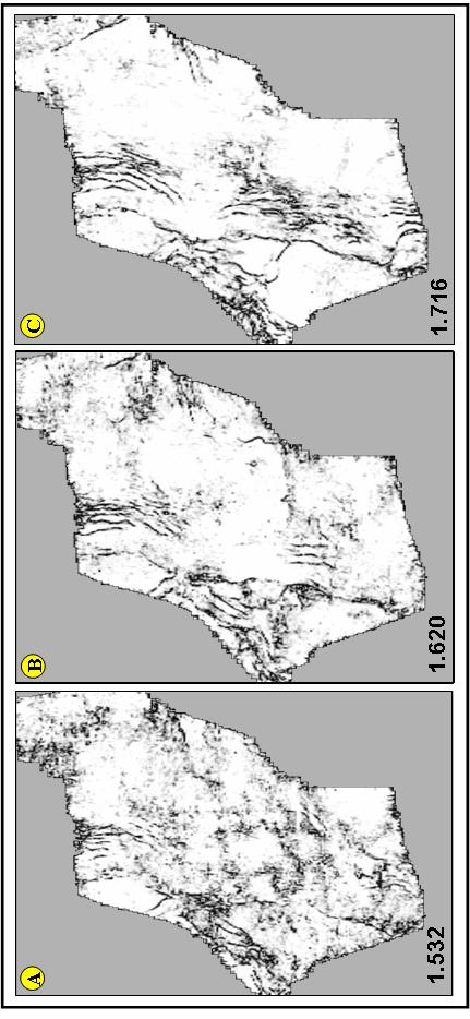
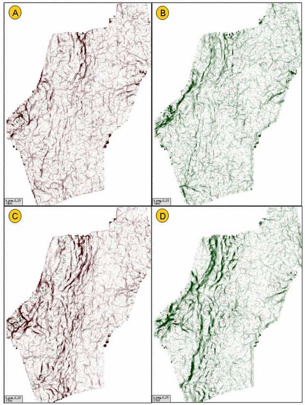
6 estimated by looking at several vertical seismic lines from both the UPR and the BEG 3D seismic surveys. The seismic crossline in Figure 12a illustrates that the BMF interval is deformed by the subsidiary faults on the hanging wall side of the AD fault and is accommodated mainly by synthetic faulting. The difference between the level of details in this 3D seismic crossline and that presented by Levey et al., (1993) (Figure 2) is dramatic. Recognizing such details from regional 2D seismic sections and well data alone is not possible. This comparison clearly illustrates the power of 3D seismic volumes over 2D seismic grids. The deformation is more pronounced in the area closer to the AD growth fault. Approximately, 1.5-mile (2.4-km) distant from the trace of the AD fault in the down-basin direction, we note an average of five secondary faults that affect the stratigraphic units of the BMF interval (F39-F11), with the deeper horizons (e.g. F39) being more deformed than the shallower horizons (e.g. F11). The vertical seismic section shown in Figure 12b illustrates the deformation of the deeper middle Frio in the footwall side of the AD fault. It shows that antithetic faulting accommodates the AD fault footwall deformation, the opposite case of the hanging wall deformation, and is more intense in the northern part of the UPR 3D seismic volume (southern Agua Dulce field area) than in the southern part (northern Stratton field area). Note the difference between the structure details which appear in this seismic line and that presented by Levey et al., (1993) (Figure 2). Several synthetic and antithetic faults affect the deeper middle Frio interval (G2-E41) and younger horizons. The coherence slices shown in Figure 13 indicate that the studied BMF interval is clearly affected at different stratigraphic levels by several growth faults that occur in different parts of the image area. Figure 14 shows maximum positive and maximum negative curvature attributes that also indicate that the BMF interval is deformed by many faults. These faults are assumed to result in more compartmentalization of the fluvial channels embedded in the studied BMF stratigraphic interval. 6
7 Fault offsets. The vertical displacements of the major and subsidiary growth faults mapped in the study area were measured from both vertical seismic sections (inlines and crosslines) and well log cross sections. Based on observations made from the two-3d seismic volumes, it was found that the amount of fault throws of major and minor faults vary from line to line in the seismic surveys and increases in the northern part of the UPR 3D seismic survey in the Agua Dulce field area. The amount of vertical separation of the AD growth fault increases with depth and ranges between 850 ft (259 m) to 1600 ft (488 m). For the subsidiary synthetic and antithetic faults, vertical displacements range from 15 ft (5 m) to 145 ft (44 m). These subtle small-throw faults can be a significant part in the creation of multiple reservoir compartments within the middle Frio Formation. Structure Architecture Model for the Middle Frio Formation. One of the objectives of this study is to test the hypothesis of whether or not synthetic and antithetic faults cut through the middle Frio Formation in the area of the Stratton-Agua Dulce fields. Investigating the BMF interval (G2-F11) from the available two 3D seismic data volumes and well log data (Figures 5-14) shows that the studied middle Frio horizons (e.g. F11 and F39) become segmented or compartmentalized by the effect of the subsidiary synthetic and antithetic faults associated with the major growth faults. Based on these findings, we propose a new structural architecture model (Figure 15) for the BMF interval. In this model, the interval between F11 and G2 has been broken into several compartments by major and secondary growth faults. At about 2.75-mile (4.5-km) distance from the trace of the AD growth fault, the BMF horizons split into several reservoir compartments due to, on average, seven synthetic and antithetic faults cutting through this interval. Movements along these individual faults may result in several compartmentalized 7
8 traps rather than one undeformed larger rollover anticlinal trap. In the footwall block of the AD fault, antithetic faults are common and displace the BMF and younger horizons. In the middle Frio Formation at Stratton field, Kerr and Jirik (1990) and Yang (1998) recognized two architectural end members: the concentrated and the dispersed sandstone bodies. These architectural styles were noted on the hanging wall side of the AD growth fault. Figure 16 is a robust rollover anticline from Stratton field that shows that shows good examples of the concentrated and the dispersed facies architectural styles. In this interval, and based on well data and 2D seismic data (Levey et al. 1993) the structure attitude is mostly affected by the master growth faults while all the antithetic and synthetic faults are diminished. This facies architectural model proposed by Kerr and Jirik (1990) and Yang (1998) did not account for the effect of the secondary faults on the architecture of the middle Frio strata. This model can be modified to include the effects of the major and subsidiary faults together on the middle Frio interval as presented by this study (Figure 17). In addition, syndepositional movements of these growth faults may result in the creation of more accommodation space and in the avulsion of the BMF fluvial channel belts. Thus, in order for more development of the middle Frio reservoirs in the Stratton-Agua Dulce area and in the Texas Gulf Coast basin as well, the structural and the facies architectural models (Figures 15 and 17) presented by this study should be taken into consideration. CONCLUSION In this paper, an example from the Texas Gulf Coast of the United States showed that information extracted from two 3D seismic data volumes resulted in the enhancement and more understanding of the structural styles and architecture and in accurate delineation of 8
9 reservoir blocks in the area of study. The results of this work promise for more development opportunities in the Stratton-Agua Dulce area in the FR-4 (Frio gas play) in south Texas. At Stratton and Agua Dulce fields in south Texas new structural and facies architectural models proposed and show that the Vicksburg and AD faults and numerous subsidiary synthetic and antithetic faults are syndepositional and cut through the BMF and younger horizons. These faults affect the architecture of the sandstone bodies stacked in these intervals. ACKNOWLEDGEMENTS The first author is grateful to the Geosciences Department of the University of Tulsa, Oklahoma, especially Dennis Kerr and Dr. Christopher Liner (now with Saudi Aramco) for their guidance and help to achieve this study. Special thanks to Anadarko Petroleum Corporation for providing the UPR 3D seismic survey and to the State of Texas Bureau of Economic Geology for providing seismic data licenses to the University of Tulsa for use in education and research. Suggested Readings. The impact of 3D seismic data on exploration, field development, and production. In: Weimer, P., and Davis, T.L., 1996, Applications of 3D seismic data to exploration and production. AAPG Studies in Geology, No. 42 and SEG Geophysical Developments series No. 5, AAPG/SEG, Tulsa, p. 1-8 (by Nestvold, 1996); Structural Geology. W.H. Freeman and Company, USA, P (by Twiss, R. and Moores, E., 1992). Interpretation of Three-Dimensional Seismic Data, AAPG Memoir 42, Fifth Edition, p (By Brown, 1999). TABLE OF FIGURE CAPTIONS 9
10 Figure 1. Index map showing the location of the Stratton and Agua Dulce fields in south Texas, the location of the UPR and the BEG 3D seismic surveys, and the well in which the VSP survey was run. Figure 2. Interpreted regional 2D seismic line passing through the Wardner lease area of Stratton field showing rotation of fault blocks in the lower Frio and Vicksburg Formations compared to the lack of faulting in the middle Frio Formation, (from Levey, et al., 1993). Figure 3. Reference log from well Wardner 177 showing reservoir subdivisions and markers of the basal middle Frio interval (BMF) used in this study. T= top, B= base, m= marker. Figure 4. VSP display of Wardner 175 well (Modified from Hardage, et al., 1996). Some horizons of interest: e.g. F11 and F39 are located at ~1.58 s and ~1.65 s, respectively. The peaks (black-filled to the right) are top of reservoir units. Figure 5. (a) Geological cross section showing the disparity in thickness of the BMF interval (MTE41-MTG2) on both sides of the AD fault. The hanging wall is deformed by the rollover anticline and a set of synthetic and antithetic faults. (b) Coincident arbitrary seismic line from the UPR 3D seismic survey showing the AD listric normal fault and the associated structures. Displacement on the AD growth fault occurs during sedimentation resulting in equivalent beds being thicker in the hanging wall block than in the footwall block. Figure 6. Isochron map extracted between F11 and F39 reflectors from the UPR 3D seismic volume. Thick isochrons (dark colors) indicate the growth of the faults. 10
11 Figure 7. (a) Well log cross section showing that the minor antithetic faults associated with the AD fault are also syndepositional (growth) faults. The growth of the fault as measured between MTE41 and MBF39 is approximately 126 ft in the hanging wall side of the fault. This growth is evident in the thickening of the individual layers such as F11 and F39. Location of the cross section is indicated in Figure 9. (b) Coincident arbitrary seismic line (from the BEG 3D seismic survey) showing the antithetic fault (AF) in Fig. 7a. Figure 8. (a) Well log cross section showing that the subsidiary synthetic faults associated with the AD fault are syndepositional (growth) faults. The interval between F11 and F39 are thicker in the hanging wall by 44ft than in the footwall side of the synthetic fault. Location of the cross section is indicated in Figure 9. (b) Arbitrary seismic line (from the UPR 3D seismic survey) showing the synthetic fault (SF) in (a). Figure 9. Structure contour map constructed on top of the F11 horizon in Stratton field area based on well data, showing only the AD fault and one subsidiary fault (From Yang, 1998). Figure 10. Time structure map constructed on top of the F11 horizon from the BEG and the UPR 3D seismic surveys. Fault polygons indicate the locations of the major faults and several secondary faults. These secondary faults were not shown before (compare with Figures 2 and 9) at the F11 stratigraphic level. Figure 11. 3D view of the F11 structure from the BEG 3D seismic survey clearly showing surface irregularities in the hanging wall rollover anticline that indicate the locations of the secondary faults associated with the major AD fault. 11
12 Figure 12. (a) Seismic crossline from the UPR 3D seismic survey showing the deformation on the hanging wall side of the AD fault. All the subsidiary faults are affecting the deeper middle Frio (G2-F11). Note the difference in structure details in this seismic line and that shown in Figure 2. (b) Another seismic crossline from the same survey showing deformation in the footwall block of the AD fault. Figure 13. Three coherence slices near the top (a), near the middle (b) and near the bottom (c) of the BMF interval corresponding to the UPR survey showing that the whole BMF stratigraphic interval is clearly affected by many large and subtle faults. Figure 14. Maximum positive (a), (c) and maximum negative (b), (d) curvature 3D attributes extracted near the top (a), (b) and near the bottom (c), (d) of the BMF interval. These attribute maps clearly show the locations of the faults that affect the BMF interval. Figure 15. Structural architecture model based on seismic and geological observations showing the effects of the major and subsidiary growth faults on the deeper middle Frio succession in the Stratton and Agua Dulce fields, south Texas. The faults displace the horizons into several compartments. Deformation is more pronounced in the hanging wall sides of the growth faults. AD fault footwall deformation is common in northern Stratton field and southern Agua Dulce Figure 16. Regional well log structural cross section showing good example of a rollover anticline developed on the hanging wall of the major Agua Dulce fault in the Stratton field area. The stacking patterns of the BMF fluvial sandstone reservoirs ranges from dispersed architecture (multiple vertically stacked sand bodies that have limited lateral continuity and 12
13 separated vertically by thick layers of floodplain mudstones) closer to the major growth fault to concentrated architecture (multiple laterally stacked sand bodies that have more lateral continuity and separated vertically by thin layers of floodplain mudstones) along the crest of the rollover anticline. Location of the cross section is indicated in Figure 9. Figure 17. Schematic 2D facies architectural model of the BMF stratigraphic interval. Deformation caused by growth fault (major and subsidiary) activity is one possible factor controlling the BMF fluvial architectural styles in the study area. Thickness and number of sandstone bodies increase on the hanging wall sides of the growth faults relative to the footwalls (modified from Kerr and Jirik, 1990, and Yang, 1998). 13
14 1
15 2
16 3
17 4
18 5
19 6
20 7
21 8
22 9
23 10
24 11
25 12
26 13
27 14
28 15
29 16
30 17
31 18
Kinematic structural forward modeling for fault trajectory prediction in seismic interpretation
 Fault prediction by forward modeling Kinematic structural forward modeling for fault trajectory prediction in seismic interpretation Mohammed Alarfaj and Don C. Lawton ABSTRACT The unique relationship
SAND DISTRIBUTION AND RESERVOIR CHARACTERISTICS NORTH JAMJUREE FIELD, PATTANI BASIN, GULF OF THAILAND
 SAND DISTRIBUTION AND RESERVOIR CHARACTERISTICS NORTH JAMJUREE FIELD, PATTANI BASIN, GULF OF THAILAND Benjawan KIinkaew Petroleum Geoscience Program, Department of Geology, Faculty of Science, Chulalongkorn
Bulletin of Earth Sciences of Thailand. Evaluation of the Petroleum Systems in the Lanta-Similan Area, Northern Pattani Basin, Gulf of Thailand
 Evaluation of the Petroleum Systems in the Lanta-Similan Area, Northern Pattani Basin, Gulf of Thailand Sirajum Munira Petroleum Geoscience Program, Department of Geology, Faculty of Science, Chulalongkorn
Constrained Fault Construction
 Constrained Fault Construction Providing realistic interpretations of faults is critical in hydrocarbon and mineral exploration. Faults can act as conduits or barriers to subsurface fluid migration and
Bulletin of Earth Sciences of Thailand. Controls on Reservoir Geometry and Distribution, Tantawan Field, Gulf of Thailand.
 Controls on Reservoir Geometry and Distribution, Tantawan Field, Gulf of Thailand Atchara Praidee Petroleum Geoscience Program, Department of Geology, Faculty of Science, Chulalongkorn University, Bangkok
Bulletin of Earth Sciences of Thailand
 Quantitative Seismic Geomorphology of Early Miocene to Pleistocene Fluvial System of Northern Songkhla Basin, Gulf of Thailand Oanh Thi Tran Petroleum Geoscience Program, Department of Geology, Faculty
Seismic Inversion on 3D Data of Bassein Field, India
 5th Conference & Exposition on Petroleum Geophysics, Hyderabad-2004, India PP 526-532 Seismic Inversion on 3D Data of Bassein Field, India K.Sridhar, A.A.K.Sundaram, V.B.G.Tilak & Shyam Mohan Institute
Bulletin of Earth Sciences of Thailand. A study of Reservoir Connectivity in the Platong Field, Pattani Basin, Gulf of Thailand. Hathairat Roenthon
 A study of Reservoir Connectivity in the Platong Field, Pattani Basin, Gulf of Thailand Hathairat Roenthon Petroleum Geoscience Program, Department of Geology, Faculty of Science, Chulalongkorn University,
Fault seal analysis: a regional calibration Nile delta, Egypt
 International Research Journal of Geology and Mining (IRJGM) (2276-6618) Vol. 3(5) pp. 190-194, June, 2013 Available online http://www.interesjournals.org/irjgm Copyright 2013 International Research Journals
Downloaded 10/10/13 to Redistribution subject to SEG license or copyright; see Terms of Use at
 Characterizing a fault-zone and associated fractures using lab experiments and attribute-based seismic analysis: an example from Woodford Shale, Anadarko basin, Oklahoma Zonghu Liao*, Ze ev Reches, and
Multiattributes and Seismic Interpretation of Offshore Exploratory Block in Bahrain A Case Study
 Multiattributes and Seismic Interpretation of Offshore Exploratory Block in Bahrain A Case Study Suresh Thampi, Aqeel Ahmed, Yahya Al-Ansari, Ali Shehab, Ahmed Fateh, Anindya Ghosh, Ghada Almoulani. The
APPENDIX C GEOLOGICAL CHANCE OF SUCCESS RYDER SCOTT COMPANY PETROLEUM CONSULTANTS
 APPENDIX C GEOLOGICAL CHANCE OF SUCCESS Page 2 The Geological Chance of Success is intended to evaluate the probability that a functioning petroleum system is in place for each prospective reservoir. The
Quick Look Interpretation Techniques
 Quick Look Interpretation Techniques Odd Number of Contours A basic rule of contouring is that ALL contours on a continuous surface must close or end at the edge of the map. This rule seems so obvious
Trapping Mechanisms along North Similan and Lanta Trends, Pattani Basin, Gulf of Thailand
 Trapping Mechanisms along North Similan and Lanta Trends, Pattani Basin, Gulf of Thailand Piyaporn Aukkanit Petroleum Geoscience Program, Department of Geology, Faculty of Science, Chulalongkorn University,
technical article Satinder Chopra 1*, Kurt J. Marfurt 2 and Ha T. Mai 2
 first break volume 27, October 2009 technical article Using automatically generated 3D rose diagrams for correlation of seismic fracture lineaments with similar lineaments from attributes and well log
Downloaded 09/15/16 to Redistribution subject to SEG license or copyright; see Terms of Use at
 A Full Field Static Model of the RG-oil Field, Central Sirte Basin, Libya Abdalla Abdelnabi*, Kelly H. Liu, and Stephen Gao Missouri University of Science and Technology Summary Cambrian-Ordovician and
Geometric attributes such as coherence and curvature are
 SATINDER CHOPRA, Arcis Seismic Solutions, Calgary, Canada KURT J. MARFURT, University of Oklahoma, Norman, USA Geometric attributes such as coherence and curvature are commonly used for mapping structural
STRUCTURAL INTERPRETATION AND HYDROCARBON POTENTIAL OF OBUA FIELD, NIGER DELTA, SOUTHERN NIGERIA
 STRUCTURAL INTERPRETATION AND HYDROCARBON POTENTIAL OF OBUA FIELD, NIGER DELTA, SOUTHERN NIGERIA 1 Iwuoma Juliet Onyinyechukwu and 2 Minapuye I. Odigi 1 Department of Geology, University of Port Harcourt,
Evaluation of Hydrocarbon Volume in TRH Field, Onshore Niger Delta, Nigeria
 International Journal of Geophysics and Geochemistry 2015; 2(5): 113-123 Published online October 10, 2015 (http://www.aascit.org/journal/ijgg) ISSN: 2381-1099 (Print); ISSN: 2381-1102 (Online) Evaluation
Delineation of tectonic features offshore Trinidad using 3-D seismic coherence
 CORNER INTERPRETER S Coordinated by llen ertagne Delineation of tectonic features offshore Trinidad using 3-D seismic coherence DM GERSZTENKORN, Tulsa, Oklahoma, U.S. JOHN SHRP, P moco, Houston, Texas,
SEG/San Antonio 2007 Annual Meeting
 ; Application to Forth Worth Basin Suat Aktepe, Kurt J. Marfurt, Center for Applied Geosciences and Energy, Dept. of Geosciences, University of Houston Summary By definition, the focus of seismic exploration
P066 Duplex Wave Migration for Coal-bed Methane Prediction
 P066 Duplex Wave Migration for Coal-bed Methane Prediction N. Marmalevskyi* (Ukrainian State Geological Prospecting Institute), A. Antsiferov (UkrNIMI), Z. Gornyak (Ukrainian State Geological Prospecting
Southern Songkhla Basin, Gulf of Thailand
 Architecture and Depositional Environment of Fluvial Systems of Southern Songkhla Basin, Gulf of Thailand Toan Manh Do Petroleum Geoscience Program, Department of Geology, Faculty of Science, Chulalongkorn
MUHAMMAD S TAMANNAI, DOUGLAS WINSTONE, IAN DEIGHTON & PETER CONN, TGS Nopec Geological Products and Services, London, United Kingdom
 Geological and Geophysical Evaluation of Offshore Morondava Frontier Basin based on Satellite Gravity, Well and regional 2D Seismic Data Interpretation MUHAMMAD S TAMANNAI, DOUGLAS WINSTONE, IAN DEIGHTON
Title: A texture-based approach for automated detection of listric faults
 Title: A texture-based approach for automated detection of listric faults Author(s): Muhammad Amir Shafiq *, Haibin Di, and Ghassan AlRegib Center for Energy and Geo Processing (CeGP), School of Electrical
Quantifying Bypassed Pay Through 4-D Post-Stack Inversion*
 Quantifying Bypassed Pay Through 4-D Post-Stack Inversion* Robert Woock 1, Sean Boerner 2 and James Gamble 1 Search and Discovery Article #40799 (2011) Posted August 12, 2011 *Adapted from oral presentation
Vail et al., 1977b. AAPG 1977 reprinted with permission of the AAPG whose permission is required for further use.
 Well 5 Well 4 Well 3 Well 2 Well 1 Vail et al., 1977b AAPG 1977 reprinted with permission of the AAPG whose permission is required for further use. Well 5 Well 4 Well 3 Well 2 Well 1 Vail et al., 1977b
Seismic attributes for fault/fracture characterization
 Satinder Chopra* and Kurt J. Marfurt + *Arcis Corporation, Calgary; + University of Houston, Houston Summary Seismic attributes have proliferated in the last three decades at a rapid rate and have helped
I. INTRODUCTION 1.1. Background and Problem Statement
 I. INTRODUCTION 1.1. Background and Problem Statement The declining of global oil and gas reserves has encouraged the exploration campaign to both the frontier area and the revisit to the mature basins.
Downloaded 01/29/13 to Redistribution subject to SEG license or copyright; see Terms of Use at
 An integrated study of a Mississippian tripolitic chert reservoir Osage County, Oklahoma, USA Benjamin L. Dowdell*, Atish Roy, and Kurt J. Marfurt, The University of Oklahoma Summary With the advent of
Nemaha Strike-Slip Fault Expression on 3-D Seismic Data in SCOOP Trend
 Nemaha Strike-Slip Fault Expression on 3-D Seismic Data in SCOOP Trend June 2018 Satinder Chopra, Kurt Marfurt, Folarin Kolawole, Brett M. Carpenter Fthe meaningful recognition of the faults within the
FINAL REPORT INTEGRATING P-WAVE AND S-WAVE SEISMIC DATA TO IMPROVE CHARACTERIZATION OF OIL RESERVOIRS. Innocent J. Aluka
 1 FINAL REPORT INTEGRATING P-WAVE AND S-WAVE SEISMIC DATA TO IMPROVE CHARACTERIZATION OF OIL RESERVOIRS by Innocent J. Aluka Prepared for U.S. Department of Energy Under Grant No. DE-FG26-00NT40832 Department
The Stratigraphic Trap in the Benchamas Field Pattani Basin, Gulf of Thailand
 The Stratigraphic Trap in the Benchamas Field Pattani Basin, Gulf of Thailand Jurairat Buangam Petroleum Geoscience Program, Department of Geology, Faculty of Science, Chulalongkorn University, Bangkok
Structural Style and Tectonic Evolution of the Nakhon Basin, Gulf of Thailand
 Structural Style and Tectonic Evolution of the Nakhon Basin, Gulf of Thailand Piyaphong Chenrai Petroleum Geoscience Program, Department of Geology, Faculty of Science, Chulalongkorn University, Bangkok
Hydrocarbon Potential of the Marginal Fields in Niger Delta Oza Field, a case study*
 Hydrocarbon Potential of the Marginal Fields in Niger Delta Oza Field, a case study* J.N. Sahu 1, C.H.V. Satya Sai 1, V. Chintamani 1 and C. Vishnu Vardhan 1 Search and Discovery Article #20182 (2012)*
PETROLEUM GEOSCIENCES GEOLOGY OR GEOPHYSICS MAJOR
 PETROLEUM GEOSCIENCES GEOLOGY OR GEOPHYSICS MAJOR APPLIED GRADUATE STUDIES Geology Geophysics GEO1 Introduction to the petroleum geosciences GEO2 Seismic methods GEO3 Multi-scale geological analysis GEO4
Seismic modeling evaluation of fault illumination in the Woodford Shale Sumit Verma*, Onur Mutlu, Kurt J. Marfurt, The University of Oklahoma
 Seismic modeling evaluation of fault illumination in the Woodford Shale Sumit Verma*, Onur Mutlu, Kurt J. Marfurt, The University of Oklahoma Summary The Woodford Shale is one of the more important resource
Seismic Attributes and Their Applications in Seismic Geomorphology
 Academic article Seismic Attributes and Their Applications in Seismic Geomorphology Sanhasuk Koson, Piyaphong Chenrai* and Montri Choowong Department of Geology, Faculty of Science, Chulalongkorn University,
Course Title: Discipline: Geology Level: Basic-Intermediate Duration: 5 Days Instructor: Prof. Charles Kluth. About the course: Audience: Agenda:
 Course Title: Structural Geology Discipline: Geology Level: Basic-Intermediate Duration: 5 Days Instructor: Prof. Charles Kluth About the course: This course covers the basic ideas of structural geometry
Applications of texture attribute analysis to 3D seismic data
 INTERPRETER S CORNER Coordinated by Rebecca B. Latimer Applications of texture attribute analysis to 3D seismic data SATINDER CHOPRA and VLADIMIR ALEXEEV, Arcis Corporation, Calgary, Alberta, Canada In
A.K. Khanna*, A.K. Verma, R.Dasgupta, & B.R.Bharali, Oil India Limited, Duliajan.
 P-92 Application of Spectral Decomposition for identification of Channel Sand Body in OIL s operational area in Upper Assam Shelf Basin, India - A Case study A.K. Khanna*, A.K. Verma, R.Dasgupta, & B.R.Bharali,
The characteristics of fracture dense belt and its effect on hydrocarbon. accumulation in the Putaohua reservoir, Xingnan oilfield, Daqing
 The characteristics of fracture dense belt and its effect on hydrocarbon accumulation in the Putaohua reservoir, Xingnan oilfield, Daqing 1 Y.Y. YIN,2 Zh. Luo, 3Q. Li, 4X.R. Wang 1 School of Energy Resources,
Meandering Miocene Deep Sea Channel Systems Offshore Congo, West Africa
 Meandering Miocene Deep Sea Channel Systems Offshore Congo, West Africa S. Baer* (PGS), J. E. Comstock (PGS), K. Vrålstad (PGS), R. Borsato (PGS), M. Martin (PGS), J.P. Saba (SNPC), B. Débi-Obambé (SNPC)
RELINQUISHMENT REPORT. UK Traditional Licence P Blocks 12/16b & 12/17b. First Oil Expro Limited (Operator, 46.67%)
") RELINQUISHMENT REPORT UK Traditional Licence P.1887 Blocks 12/16b & 12/17b First Oil Expro Limited (Operator, 46.67%) Nautical Petroleum Limited (26.67%) North Sea Energy (UK NO2) Limited (26.67%) February
RELINQUISHMENT REPORT UK Traditional Licence P.1887 Blocks 12/16b & 12/17b First Oil Expro Limited (Operator, 46.67%) Nautical Petroleum Limited (26.67%) North Sea Energy (UK NO2) Limited (26.67%) February
Recent developments in object modelling opens new era for characterization of fluvial reservoirs
 Recent developments in object modelling opens new era for characterization of fluvial reservoirs Markus L. Vevle 1*, Arne Skorstad 1 and Julie Vonnet 1 present and discuss different techniques applied
Using Curvature to Map Faults, Fractures
 Using Curvature to Map Faults, Fractures by SATINDER CHOPRA and KURT J. MARFURT Editor s note: Chopra is with Arcis Corp., Calgary, Canada; Marfurt is with the University of Oklahoma. Both are AAPG members.
Seismic Expressions of Submarine Channel - Levee Systems and Their Architectural Elements
 Seismic Expressions of Submarine Channel - Levee Systems and Their Architectural Elements Summary D.V. Ramana, Santanu De* and Kalyanbrata Datta KDMIPE, ONGC, Dehradun E-mail- devvenram@rediffmail.com
Hamed Z. El-Mowafy 1, Mohammed Ibrahim 2, and Dallas B. Dunlap 3
 Unlocking gas reserves in bypassed stratigraphic traps in a deepwater brownfield using prestack seismic inversion: A case study from offshore Nile Delta, Egypt Hamed Z. El-Mowafy 1, Mohammed Ibrahim 2,
Integrated well log and 3-D seismic data interpretation for the Kakinada area of KG PG offshore basin
 IOSR Journal of Applied Geology and Geophysics (IOSR-JAGG) e-issn: 2321 0990, p-issn: 2321 0982.Volume 5, Issue 4 Ver. II (Jul. Aug. 2017), PP 01-05 www.iosrjournals.org Integrated well log and 3-D seismic
Detecting fractures using time-lapse 3C-3D seismic data
 data Zimin Zhang, Don C. Lawton and Robert R. Stewart ABSTRACT This report presents the interpretation of time-lapse 3C-3D seismic data for fracture detection in a Saskatchewan potash mine. Seismic interpretation
Appendix B: Geophysical Data (Thesis Appendix, 2013)
") Utah State University From the SelectedWorks of David J Richey 2013 Appendix B: Geophysical Data (Thesis Appendix, 2013) David J Richey, Utah State University Available at: https://works.bepress.com/david_richey/2/
Utah State University From the SelectedWorks of David J Richey 2013 Appendix B: Geophysical Data (Thesis Appendix, 2013) David J Richey, Utah State University Available at: https://works.bepress.com/david_richey/2/
Available online Journal of Scientific and Engineering Research, 2018, 5(1):1-10. Research Article
:1-10. Research Article") Available online www.jsaer.com, 2018, 5(1):1-10 Research Article ISSN: 2394-2630 CODEN(USA): JSERBR Evaluation of Reservoir Production Performance Using 3-D Seismic Mapping and Well Logs Analysis (A Case
Available online www.jsaer.com, 2018, 5(1):1-10 Research Article ISSN: 2394-2630 CODEN(USA): JSERBR Evaluation of Reservoir Production Performance Using 3-D Seismic Mapping and Well Logs Analysis (A Case
The SPE Foundation through member donations and a contribution from Offshore Europe
 Primary funding is provided by The SPE Foundation through member donations and a contribution from Offshore Europe The Society is grateful to those companies that allow their professionals to serve as
Potential Hydrocarbon Discoveries in Bjelovar Subdepression, Croatia By Tomislav Malvic 1 and Igor Rusan 2
 Potential Hydrocarbon Discoveries in Bjelovar Subdepression, Croatia By Tomislav Malvic 1 and Igor Rusan 2 Search and Discovery Article #10133 (2007) Posted September 25, 2007 1 INA-Industrija nafte, d.d.,
Th C3 08 Capturing Structural Uncertainty in Fault Seal Analysis A Multi-throw Scenario Approach
 Th C3 08 Capturing Structural Uncertainty in Fault Seal Analysis A Multi-throw Scenario Approach M. Giba* (DEA) Summary An intrinsic challenge of fault seal analyses is the large uncertainties that have
Hydrocarbon Volumetric Analysis Using Seismic and Borehole Data over Umoru Field, Niger Delta-Nigeria
 International Journal of Geosciences, 2011, 2, 179-183 doi:10.4236/ijg.2011.22019 Published Online May 2011 (http://www.scirp.org/journal/ijg) Hydrocarbon Volumetric Analysis Using Seismic and Borehole
Relinquishment Report
 Relinquishment Report Licence P1403 Block 13/22d Chevron North Sea Limited Korean National Oil Company Chevron North Sea Limited December 2009 1 SYNOPSIS... 3 2 INTRODUCTION. 3 2.1 Licence Terms.. 3 2.2
Tu P05 06 Duplex Wave Migration Case Study in Yemen
 Tu P05 06 Duplex Wave Migration Case Study in Yemen G. Markarova* (Calvalley Petroleum Inc), I. Blumentsvaig (TetraSeis Inc.), A. Kostyukevych (TetraSeis Inc.) & N. Marmalyevskyy (TetraSeis Inc.) SUMMARY
Shallow Gas Prospect Evaluation in Shahbazpur Structure Using Seismic Attributes Analysis - a Case Study for Bhola Island, Southern Bangladesh
 Dhaka Univ. J. Sci. 64(2): 135-140, 2016 (July) Shallow Gas Prospect Evaluation in Shahbazpur Structure Using Seismic Attributes Analysis - a Case Study for Bhola Island, Southern Bangladesh Morshedur
Quantitative Seismic Interpretation An Earth Modeling Perspective
 Quantitative Seismic Interpretation An Earth Modeling Perspective Damien Thenin*, RPS, Calgary, AB, Canada TheninD@rpsgroup.com Ron Larson, RPS, Calgary, AB, Canada LarsonR@rpsgroup.com Summary Earth models
OIL INDIA LIMITED, GEOPHYSICS DEPARTMENT, DULIAJAN, ASSAM.
 J. P. Singh, M. K. Gupta & Akshaya Kumar, Oil India Limited, Duliajan. jpsingh@oilindia.in Summary Oil exploration in Upper Assam commenced with the discovery of the Digboi oilfield more than 100 years
Reservoir characterization
 1/15 Reservoir characterization This paper gives an overview of the activities in geostatistics for the Petroleum industry in the domain of reservoir characterization. This description has been simplified
Integration of Well Logs and Seismic Data for Prospects Evaluation of an X Field, Onshore Niger Delta, Nigeria
 International Journal of Geosciences, 2012, 3, 872-877 http://dx.doi.org/10.4236/ijg.2012.324088 Published Online September 2012 (http://www.scirp.org/journal/ijg) Integration of Well Logs and Seismic
Simultaneous Inversion of Clastic Zubair Reservoir: Case Study from Sabiriyah Field, North Kuwait
 Simultaneous Inversion of Clastic Zubair Reservoir: Case Study from Sabiriyah Field, North Kuwait Osman Khaled, Yousef Al-Zuabi, Hameed Shereef Summary The zone under study is Zubair formation of Cretaceous
RESERVOIR CHARACTERIZATION USING SEISMIC AND WELL LOGS DATA (A CASE STUDY OF NIGER DELTA)
") RESERVOIR CHARACTERIZATION USING SEISMIC AND WELL LOGS DATA (A CASE STUDY OF NIGER DELTA) * ESHIMOKHAI, S. and AKHIREVBULU, O.E. http://dx.doi.org/10.4314/ejesm.v5i4.s20 Received 19th June 2012; accepted
RESERVOIR CHARACTERIZATION USING SEISMIC AND WELL LOGS DATA (A CASE STUDY OF NIGER DELTA) * ESHIMOKHAI, S. and AKHIREVBULU, O.E. http://dx.doi.org/10.4314/ejesm.v5i4.s20 Received 19th June 2012; accepted
The coherence cube. MIKE BAHORICH Amoco Corporation Denver, CO. Faults parallel to strike. Conventional amplitude time
 3-D seismic discontinuity for faults and stratigraphic features: The coherence cube MIKE BAHORICH Amoco Corporation Denver, CO STEVE FARMER Amoco Corporation Tulsa, OK Seismic data are usually acquired
Lower Skinner Valley Fill Sandstones: Attractive Exploration Targets on the Northeast Oklahoma Platform*
 Lower Skinner Valley Fill Sandstones: Attractive Exploration Targets on the Northeast Oklahoma Platform* By Jim Puckette 1 Search and Discovery Article #10050 (2003) *Adapted from presentation to Tulsa
Seismic Resolution: Thinner than first believed
 Seismic Resolution: Thinner than first believed Thomas A. Pierle* Schlumberger Summary Ever since the time of Widess(1973), seismic resolution of thin layers was limited to measuring the length of the
Serica Energy (UK) Limited. P.1840 Relinquishment Report. Blocks 210/19a & 210/20a. UK Northern North Sea
 Limited. P.1840 Relinquishment Report. Blocks 210/19a & 210/20a. UK Northern North Sea") Serica Energy (UK) Limited P.1840 Relinquishment Report Blocks 210/19a & 210/20a UK Northern North Sea January 2013 1 Header Licence: P.1840 Round: Licence Type: 26th Round Traditional "Drill-or-Drop"
Serica Energy (UK) Limited P.1840 Relinquishment Report Blocks 210/19a & 210/20a UK Northern North Sea January 2013 1 Header Licence: P.1840 Round: Licence Type: 26th Round Traditional "Drill-or-Drop"
Reconstruction of Paleogeographic Setup of Tura Formation in Rudrasagar-Disangmukh-Panidihing Area of Upper Assam Shelf using 3-D Seismic techniques
 5th Conference & Exposition on Petroleum Geophysics, Hyderabad-2004, India PP 792-796 in Rudrasagar-Disangmukh-Panidihing Area of Upper Assam Shelf using 3-D Seismic techniques S.M.Ismail 1, R.N.Dwivedi
Evolution of the Geological Model, Lobster Field (Ewing Bank 873)
") Evolution of the Geological Model, Lobster Field (Ewing Bank 873) M.K. Burk, Marathon Oil Company G.L. Brown, Marathon Oil Company D.R. Petro, Marathon Oil Company Throughout the life of a field an accurate
Evolution of the Geological Model, Lobster Field (Ewing Bank 873) M.K. Burk, Marathon Oil Company G.L. Brown, Marathon Oil Company D.R. Petro, Marathon Oil Company Throughout the life of a field an accurate
Characterizing Seal Bypass Systems at the Rock Springs Uplift, Southwest Wyoming, Using Seismic Attribute Analysis*
 Characterizing Seal Bypass Systems at the Rock Springs Uplift, Southwest Wyoming, Using Seismic Attribute Analysis* Yuri Ganshin 1 and Fred McLaughlin 1 Search and Discovery Article #80483 (2015)** Posted
Steve Cumella 1. Search and Discovery Article # (2009) Posted July 30, Abstract
 Posted July 30, Abstract") AV Geology of the Piceance Basin Mesaverde Gas Accumulation* Steve Cumella 1 Search and Discovery Article #110106 (2009) Posted July 30, 2009 *Adapted from oral presentation at AAPG Annual Convention,
AV Geology of the Piceance Basin Mesaverde Gas Accumulation* Steve Cumella 1 Search and Discovery Article #110106 (2009) Posted July 30, 2009 *Adapted from oral presentation at AAPG Annual Convention,
Delineating Karst features using Advanced Interpretation
 P-152 Asheesh Singh, Sibam Chakraborty*, Shafique Ahmad Summary We use Amplitude, Instantaneous Phase, Trace Envelope and Dip of Maximum Similarity Attributes as a tool to delineate Karst induced features
Improved Interpretability via Dual-sensor Towed Streamer 3D Seismic - A Case Study from East China Sea
 Improved Interpretability via Dual-sensor Towed Streamer 3D Seismic - A Case Study from East China Sea S. Rongfu (CNOOC Shanghai), C. Hua (CNOOC Shanghai), W. Yun (CNOOC Shanghai), Z. Yabin (CNOOC Shanghai),
Dalhousie University- Petroleum Geoscience Field Methods- Trinidad Summary Report
 Dalhousie University- Petroleum Geoscience Field Methods- Trinidad Summary Report Submitted to: Offshore Energy Research Association of Nova Scotia (OERA) To fulfill requirements of the Undergraduate Student
REGIONAL GEOLOGY IN KHMER BASIN
 CONTENTS 1-Khmere Basin 2-Regional Geology Khmer Basin 3-Regime Tectonic 4-Seismic Database -a/ Acquisition Data -b/ Prospect Angkor -C/ Cross Section Seismic 5-Play Type -a/ Play Schematic -b/ Structure
Integrating Rock Physics into the Seismic Image
 Government-Funded Exploration License Competition The project: Mid North Sea High Integrating Rock Physics into the Seismic Image Kinga Wroblewska, Geophysicist Geop4ysics Ltd Petex, 17 November 2016 Integrating
Case Study of the Structural and Depositional-Evolution Interpretation from Seismic Data*
 Case Study of the Structural and Depositional-Evolution Interpretation from Seismic Data* Yun Ling 1, Xiangyu Guo 1, Jixiang Lin 1, and Desheng Sun 1 Search and Discovery Article #20143 (2012) Posted April
A Petroleum Geologist's Guide to Seismic Reflection
 A Petroleum Geologist's Guide to Seismic Reflection William Ashcroft WILEY-BLACKWELL A John Wiley & Sons, Ltd., Publication Contents Preface Acknowledgements xi xiii Part I Basic topics and 2D interpretation
Risk Factors in Reservoir Simulation
 Risk Factors in Reservoir Simulation Dr. Helmy Sayyouh Petroleum Engineering Cairo University 12/26/2017 1 Sources Of Data Petro-physical Data Water saturation may be estimated from log analysis, capillary
RELINQUISHMENT REPORT. License P1546 Block April 2009
 RELINQUISHMENT REPORT License P1546 Block 110-01 14 April 2009 Sherritt International Oil and Gas Limited 2000, 425-1 st street S.W., Calgary, Alberta Canada T2P 3L8 Telephone (403) 260-2900 Fax (403)
Multifocusing 3D diffraction imaging for dectection of fractured zones in mudstone reservoirs
 Multifocusing 3D diffraction imaging for dectection of fractured zones in mudstone reservoirs Alana Schoepp, Evgeny Landa, Stephane Labonte Shell Canada Ltd., Geomage, Shell CanadaLtd Summary Unconventional
IJISET - International Journal of Innovative Science, Engineering & Technology, Vol. 2 Issue 9, September 2015.
 Prediction of petrophysical parameters applying multi attribute analysis and probabilistic neural network techniques of seismic data for Komombo Basin, Upper Egypt. Othman, A. A. A. 1, Ewida, H. F. 2,
In a marine environment, topographic features on the sea
 Coordinated by ALAN JACKSON Seismic attribute expression of differential compaction SATINDER CHOPRA, Arcis Seismic Solutions, Calgary, Canada KURT J. MARFURT, University of Oklahoma, Norman, USA In a marine
Application of fault seal Analysis, Buselli field, Onshore Nile Delta, Egypt
 P Application of fault seal Analysis, Buselli field, Onshore Nile Delta, Egypt 1 M. Y. Zein El-Din P P, Nabil Abdel Hafez P and Osama Mahrous P 2 3 Professor of petroleum exploration, Geology department,
3D curvature attributes: a new approach for seismic interpretation
 first break volume 26, April 2008 special topic 3D curvature attributes: a new approach for seismic interpretation Pascal Klein, Loic Richard, and Huw James* (Paradigm) present a new method to compute
Osareni C. Ogiesoba and Angela K. Eluwa. Bureau of Economic Geology, University of Texas at Austin, Burnet Rd., Austin Texas 78759
 Structural Styles of Eocene Jackson and Oligocene Vicksburg Formations within the Rio Grande and Houston Embayments near the San Marcos Arch, Refugio and Calhoun Counties, South Texas Gulf Coast Osareni
Application of Multi-Attributes and Spectral Decomposition with RGB blending for understanding the strati-structural features: A Case study
 10 th Biennial International Conference & Exposition P 262 Application of Multi-Attributes and Spectral Decomposition with RGB blending for understanding the strati-structural features: A Case study Summary
Process, Zeit Bay Fields - Gulf of Suez, Egypt*
 PS Pressure Regime Evaluation, Role, and Contribution in Well Planning and Formation Evaluation Process, Zeit Bay Fields - Gulf of Suez, Egypt* Saber Moustafa Selim 1, Khaled Mohamed Abdallah 1, and Khalaf
Finding Oil by Utilizing Play Analysis
 Finding Oil by Utilizing Play Analysis Gulf of Mexico Outer Continental Shelf An Overview of the Plio-Pleistocene and Miocene Shelf Trends Chris Williams, PG. Geoscientist Gulf of Mexico Outer Continental
Stratigraphic Trap Identification Based on Restoration of Paleogeophology and Further Division of System Tract: A Case Study in Qingshui Subsag*
 Stratigraphic Trap Identification Based on Restoration of Paleogeophology and Further Division of System Tract: A Case Study in Qingshui Subsag* Cao Laisheng 1, Yu Lin 1, Liu Jianlun 1, Xiang Sheng 1,
Quito changing isopach of the sand/shale sequences. This was fundamental to assign a realistic
 Quantitative Interpretation of Neural Network Seismic Facies -Oriente Basin Ecuador A. Williamson *, R. Walia, R. Xu, M. Koop, G. Lopez EnCana Corporation, Calgary, CGG Canada Services Ltd., Calgary, Canada
Determine the azimuths of conjugate fracture trends in the subsurface
 Reconnaissance of geological prospectivity and reservoir characterization using multiple seismic attributes on 3-D surveys: an example from hydrothermal dolomite, Devonian Slave Point Formation, northeast
SEISMIC ATTRIBUTES AND PETROPHSICAL PROPERTIES OF IBA FIELD, NIGER DELTA, NIGERIA
 SEISMIC ATTRIBUTES AND PETROPHSICAL PROPERTIES OF IBA FIELD, NIGER DELTA, NIGERIA Itiowe K 1, Adiela U.P 2 and Emudianughe J 3 1 Department of Geology, University of Port Harcourt, Port Harcourt, Nigeria
FAULT SLICING IN THE INTERPRETATION OF FAULTS IN SEISMIC DATA PROC- ESSING IN ATALA PROSPECT OF RIVER STATE, NIGERIA
 FAULT SLICING IN THE INTERPRETATION OF FAULTS IN SEISMIC DATA PROC- ESSING IN ATALA PROSPECT OF RIVER STATE, NIGERIA Egbai, J.C. Department of Physics, Delta State University, Abraka ABSTRACT e-mail: jamesegbai@yahoo.com
SEG Houston 2009 International Exposition and Annual Meeting
 Salt interpretation validated by salt tectonic study in the offshore Gulf of Mexico Li Li *, Itze Chang and Quincy Zhang, TGS-NOPEC Geophysical Company Summary To identify and define a complex salt body
Glauconitic Oil Reservoirs in Southern Alberta Creating the Correct Geological Model to Guide Development Drilling
 Glauconitic Oil Reservoirs in Southern Alberta Creating the Correct Geological Model to Guide Development Drilling Brad Hayes* Petrel Robertson Consulting Ltd, Calgary, AB bhayes@petrelrob.com Lisa Griffith
Seismic Inversion for Reservoir Characterization in Komombo Basin, Upper Egypt, (Case Study).
.") P P P Ganoub P Geology P P British P and IJISET - International Journal of Innovative Science, Engineering & Technology, Vol. 2 Issue 9, September 2015. Seismic Inversion for Reservoir Characterization
P P P Ganoub P Geology P P British P and IJISET - International Journal of Innovative Science, Engineering & Technology, Vol. 2 Issue 9, September 2015. Seismic Inversion for Reservoir Characterization
OILFIELDS STARTING OPERATION. Offshore & Downhole Technology The Woodlands, Texas Hughes Landing Blvd. #400
 OILFIELDS STARTING OPERATION MAIN ACTIVITIES Geosciences (Design & Execution) Repairing Deposits Evaluation Location Generation Biostratigraphy Production (Design & Planning) Increasing (Artificial Lifting,