LATERAL MIGRATION of ALLUVIAL CHANNELS
|
|
|
- Clyde Gallagher
- 6 years ago
- Views:
Transcription


1 LATERAL MIGRATION of ALLUVIAL CHANNELS Pierre Y. Julien Colorado State University Santiago del Estero, Argentina November
2 Objectives Discuss the lateral migration of alluvial channels and provide numerous examples on: Physical processes and morphology River mechanics and numerical modeling River engineering and management River morphology and restoration 2
3 Presentation Content Main characteristics of meandering channels Mechanics of sediment transport in curved channels Numerical modeling of meander migration Morphology of chute and neck cutoffs River engineering and management River restoration and water quality 3
")
4 Main characteristics of meandering channels (Photo by Bruce Molnia, Terra Photographics; American Geological Institute) 4
5 Meandering Channel Geometry Meander Belt, W b Meander Width, M m 0 u Meander Geometry Variables L = length of meander along the channel x = Distance along the thalweg R = Radius of curvature Rmin = Minimum radius of curvature θ = Orientation angle θm = Maximum orientation angle W b = Belt width Wm = Meander width Λ = Length of meander Λ, Meander Length Loop θ R R min θ m Inflection points Loop Convex Inner Bank Concave Outer Bank Radius of curvature is infinite at the inflection points X River length x = L Geometry drawing modeled after Julien


6 Sine-Generated Curve Meander pattern can be approximated by a sine-generated curve m cos 2 x L stream m max angle x downstream L channel angle length distance 6


7 Radius of Curvature R R L 2 m m L 2 csc m 2 x L θ R x θ m R radius of curvature R m m minimum radius of curvature max orientation angle x downstream distance L length of channel x = L From Julien (2002) 7


 8")
8 Sinuosity Λ = wavelength L sinuosity meander wavelength L length of channel From Julien (2002) 8


9 Length and Width Meander Belt Width Wm = Meander Width Λ = meander wavelength From Julien (2002) 9

10 Lateral Migration of Meandering Channels 10
11 Presentation Content Main characteristics of meandering channels Mechanics of sediment transport in curved channels Numerical modeling of meander migration Morphology of chute and neck cutoffs River engineering and management River restoration and water quality 11


12 Mechanics of sediment transport in curved channels tan λ ~ 11 h/r From Julien (2002) 12
")
13 Particle Stability on Slopes From the method of moments, different particle sizes move in different directions from Kawai and Julien (IAHR-JHR, 1996) 13


14 Sediment Transport in Sharp Bends Laboratory experiments show that fine sand can deposit where coarse sand cannot, i.e. point bars from Kawai and Julien (IAHR-JHR, 1996) 14


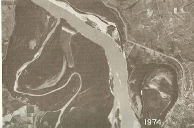
15 Roaring River Alluvial Fan: Dramatic change in sediment supply Single channel forming Q s since flood has resulted in reduced number of bifurcations and a central channel is forming. After Bathurst and Ashiq (1998) 15
16 Sediment Transport in Sharp Bends Field measurements in the sharp bends of the Fall River, Colorado demonstrate that particles of different sizes move in different directions. from Julien and Anthony (IAHR-JHR, 2002) 16
17 Presentation Content Main characteristics of meandering channels Mechanics of sediment transport in curved channels Numerical modeling of meander migration Morphology of chute and neck cutoffs River engineering and management River restoration and water quality 17
18 Numerical modeling of meander migration Model from Duan and Julien (ESPL, 2005) 18
")
19 Sediment Transport Model from Duan and Julien (ESPL, 2005) 19

20 Bank Erosion Model from Duan and Julien (ESPL, 2005) 20
21 Lateral Migration Model from Duan and Julien (ESPL, 2005) 21

22 Meandering Simulations Initial Conditions sine-generated deflection angle 30 discharge 2.1 l/s width 0.4 m length 13.2 m sediment size 0.45 mm Model from Duan and Julien (ESPL, 2005) 22

 Rio Puerco, New")
23 Meandering Evolution Example starting from a straight channel on the Rio Puerco, New Mexico Rio Puerco, New Mexico ) Model from Duan and Julien (ESPL, 2005) Rio Puerco, New Mexico 23

24 Meandering Simulations T=1.5 hrs T=6 hrs T=12 hrs from Duan and Julien (J. Hydrol., 2010) 24

25 Meandering Simulations T=20 hrs Transitional Meanders T=32 hrs Final Meanders from Duan and Julien (J. Hydrol., 2010) 25


26 Meandering Evolution Stage 1 - Downstream Extension Tanana River, Alaska from Duan and Julien (J. Hydrol., 2010) 26


27 Meandering Evolution Stage 2 - Lateral Extension Tanana River, Alaska from Duan and Julien (J. Hydrol., 2010) 27


28 Meandering Evolution Stage 3 Near Equilibrium Tanana River, Alaska Duan and Julien (J. Hydrol., 2010) 28


29 Meandering Evolution Stage 4 - Upstream Migration Tanana River, Alaska from Duan and Julien (J. Hydrol., 2010) 29


30 Meandering Evolution Stage 5 - Rotation and Cutoff Tanana River, Alaska from Duan and Julien (J. Hydrol., 2010) 30
31 Presentation Content Main characteristics of meandering channels Mechanics of sediment transport in curved channels Numerical modeling of meander migration Morphology of chute and neck cutoffs River engineering and management River restoration and water quality 31


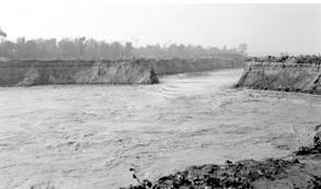
32 Morphology of chute and neck cutoffs Chute cutoffs Occur when river cuts through the point bar, thus decreasing sinuosity Channel forms a middle bar. Neck cutoffs Lateral migration increases sinuosity of the channel until two bends connect Sedimentation plug forms an abandoned channel called oxbow lake. meanding river chute cutoff 32

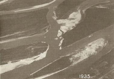
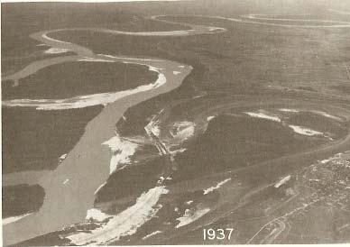
33 Natural Chute Cutoffs Often in response to an increase in sediment load Chute cutoffs on Williams River, AK (Photo by N.D. Smith) 33


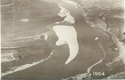
34 Natural Neck Cutoffs Geologic cutoff, San Juan River, UT (Photo by Roger Weller; Cochise College) Neck cutoff, Green River WY (Photo by Michael Collier; American Geological Institute) 34

35 Oxbow Lake 35
36 Presentation Content Main characteristics of meandering channels Mechanics of sediment transport in curved channels Numerical modeling of meander migration Morphology of chute and neck cutoffs River engineering and management River restoration and water quality 36

")
37 River engineering and management Mississippi River near Greenville, MS From Winkley (1977) 37


38 Example of Engineered Cutoffs Earth plug separating pilot channels Dynamite removal of earthen plug One hour after opening cutoff Greenville Bends Ashbrook, Tarpley and Leland Cutoffs 38
39 Mississippi River Leland and Tarpley Cutoffs From Winkley (1977) 39


")
40 Engineered Chute Cutoff Choctaw Bar, Mississippi River Current (red line = stone dikes, yellow = bare sandbar, blue = water and green = vegetation) From USACE (1999) and Julien (2002) 40


41 River Widening Nakdong River near Busan, South Korea 41

42 Gupo Bridge during Typhoon Maemi in

43 Retrofitting Bridge Piers after Riverbank Shifting From Park et al. ASCE-JHE 134(11),
,")
44 Park et al. ASCE-JHE 134(11),

45 River Management Rio Grande below Cochiti Dam, NM Braiding Transition Meandering From Richard et al. ASCE-JHE 131(11),
46 Hydraulic Geometry of the Rio Grande From Richard et al. ASCE-JHE 131(11),

47 Jetty fields and vegetation of the Rio Grande Jetty System near Bernardo NM, in 1963 MEI 47

48 Jetty System near Bernardo NM, in 2002 Bernardo Gage 48

49 Sediment Plugs on the Rio Grande From Baird, USBR 49
50 Presentation Content Main characteristics of meandering channels Mechanics of sediment transport in curved channels Numerical modeling of meander migration Morphology of chute and neck cutoffs River engineering and management River restoration and water quality 50


 51")
51 River restoration and water quality Cheongmi Stream South Korea Cheongmi Stream South Korea from Kim et al. (2011) 51

52 Historical Planform Cheongmi Stream, South Korea 52

53 Water Quality Issues Near the neck cutoffs of the Red River, LA 53

54 Water Quality Issues Near Imha Dam, South Korea From An, Sangdo, CSU and K-Water,


55 Water Quality Modeling Interflow turbidity currents at Imha Dam, SK Unit : kg/m 3 0 km 4 km from S.D. An, CSU,
56 Conclusions Physical processes and morphology Sine-generated curves describe meandering channels Mechanics and numerical modeling Secondary flow and particle stability are most important in curved channels Numerical models should include basal erosion and bank sliding processes River engineering and management River engineering requires mastery of hydraulics and sedimentation Engineering design during extreme events should be emphasized Stream restoration and water quality Restoration efforts include stream ecology and water quality 56
57 Acknowledgments S.D. An, CSU and K-Water M. Velleux, CSU, now Hydroqual J. England, USBR J. Halgren, CSU now NOAA C. Leon, CSU and RTI U. Ji, CSU and Myongji U. South Korea P. O Brien, CSU and USACE D.C. Baird, USBR J. Duan, UA D. Anthony, ME S. Kawai, Maizuru, Japan H. Woo, KICT, South Korea S.K. Park, PNU, South Korea So many others 57

58 Muchas Gracias! 58
Case Studies in River Management
 Case Studies in River Management Pierre Y. Julien Colorado State University 1) Case Studies of River Management in the US 2) Interesting River Management Issues in South Korea Middle Rio Grande, USA Camby
River Meandering and Braiding. Pierre Y. Julien. Department of Civil and Environmental Engineering Colorado State University Fort Collins, Colorado
 River Meandering and Braiding Pierre Y. Julien Department of Civil and Environmental Engineering Colorado State University Fort Collins, Colorado River Mechanics and Sediment Transport Lima Peru January
River Restoration and Rehabilitation. Pierre Y. Julien
 River Restoration and Rehabilitation Pierre Y. Julien Department of Civil and Environmental Engineering Colorado State University Fort Collins, Colorado River Mechanics and Sediment Transport Lima Peru
Stream Restoration and Environmental River Mechanics. Objectives. Pierre Y. Julien. 1. Peligre Dam in Haiti (deforestation)
") Stream Restoration and Environmental River Mechanics Pierre Y. Julien Malaysia 2004 Objectives Brief overview of environmental river mechanics and stream restoration: 1. Typical problems in environmental
Stream Restoration and Environmental River Mechanics Pierre Y. Julien Malaysia 2004 Objectives Brief overview of environmental river mechanics and stream restoration: 1. Typical problems in environmental
Channel Pattern. Channel Pattern, Meanders, and Confluences. Description of Channel Pattern. Bridge (2003)
") Channel Pattern Channel Pattern, Meanders, and Confluences Outline Description of channel pattern Alternate bars Channel pattern continua and evolution Controls of channel pattern Description of Channel
Channel Pattern Channel Pattern, Meanders, and Confluences Outline Description of channel pattern Alternate bars Channel pattern continua and evolution Controls of channel pattern Description of Channel
Lecture 19: Fluvial Facies
 GEOL 440 Sedimentology and stratigraphy: processes, environments and deposits Lecture 19: Fluvial Facies Aims Examine controls on alluvial channel pattern List the types of channel pattern Examine meandering
NATURAL RIVER. Karima Attia Nile Research Institute
 NATURAL RIVER CHARACTERISTICS Karima Attia Nile Research Institute NATURAL RIVER DEFINITION NATURAL RIVER DEFINITION Is natural stream of water that flows in channels with ih more or less defined banks.
Stream Geomorphology. Leslie A. Morrissey UVM July 25, 2012
 Stream Geomorphology Leslie A. Morrissey UVM July 25, 2012 What Functions do Healthy Streams Provide? Flood mitigation Water supply Water quality Sediment storage and transport Habitat Recreation Transportation
Step 5: Channel Bed and Planform Changes
 Step 5: Channel Bed and Planform Changes When disturbed, streams go through a series of adjustments to regain equilibrium with the flow and sediment supply of their watersheds. These adjustments often
Do you think sediment transport is a concern?
 STREAM RESTORATION FRAMEWORK AND SEDIMENT TRANSPORT BASICS Pete Klingeman 1 What is Your Restoration Project Like? k? Do you think sediment transport is a concern? East Fork Lewis River, WA Tidal creek,
Aquifer an underground zone or layer of sand, gravel, or porous rock that is saturated with water.
 Aggradation raising of the streambed by deposition that occurs when the energy of the water flowing through a stream reach is insufficient to transport sediment conveyed from upstream. Alluvium a general
Hydraulics of bendway weirs
 River Basin Management IV 389 Hydraulics of bendway weirs C. Thornton 1, S. Abt 1, D. Baird 2 & R. Padilla 3 1 Colorado State University, Fort Collins, CO, USA 2 U.S. Bureau of Reclamation, Denver, CO,
Avoiding Geohazards in the Mid-Atlantic Highlands by Using Natural Stream Principles
 Avoiding Geohazards in the Mid-Atlantic Highlands by Using Natural Stream Principles J. Steven Kite, WVU Neal Carte, WVDOT Will Harman, Michael Baker Corp. Donald D. Gray, WVU Photo: W. Gillespie North
MATHEMATICAL MODELING OF FLUVIAL SEDIMENT DELIVERY, NEKA RIVER, IRAN. S.E. Kermani H. Golmaee M.Z. Ahmadi
 JOURNAL OF ENVIRONMENTAL HYDROLOGY The Electronic Journal of the International Association for Environmental Hydrology On the World Wide Web at http://www.hydroweb.com VOLUME 16 2008 MATHEMATICAL MODELING
FUTURE MEANDER BEND MIGRATION AND FLOODPLAIN DEVELOPMENT PATTERNS NEAR RIVER MILES 241 TO 235, SACRAMENTO RIVER
 FUTURE MEANDER BEND MIGRATION AND FLOODPLAIN DEVELOPMENT PATTERNS NEAR RIVER MILES 241 TO 235, SACRAMENTO RIVER Eric W. Larsen University of California, Davis With the assistance of Evan Girvetz REPORT
FRESH SURFACE WATER Vol. III - River Navigation and Associated Structures - D. M. Admiraal, M. H. García RIVER NAVIGATION AND ASSOCIATED STRUCTURES
 RIVER NAVIGATION AND ASSOCIATED STRUCTURES D. M. Admiraal Department of Civil Engineering, University of Nebraska, USA M. H. García Department of Civil and Environmental Engineering, University of Illinois
GEOL 652. Poudre River Fieldtrip
 GEOL 652. Poudre River Fieldtrip One of the more difficult variables to measure and/or estimate when studying flow in natural channels is that of roughness. Roughness, usually approximated with Manning
Landscape Development
 Landscape Development Slopes Dominate Natural Landscapes Created by the interplay of tectonic and igneous activity and gradation Deformation and uplift Volcanic activity Agents of gradation Mass wasting
GEOL 1121 Earth Processes and Environments
 GEOL 1121 Earth Processes and Environments Wondwosen Seyoum Department of Geology University of Georgia e-mail: seyoum@uga.edu G/G Bldg., Rm. No. 122 Seyoum, 2015 Chapter 6 Streams and Flooding Seyoum,
GLG362/GLG598 Geomorphology K. Whipple October, 2009 I. Characteristics of Alluvial Channels
 I. Characteristics of Alluvial Channels Self-formed morphology set by entrainment, transport, and deposition They move unconsolidated sedimentary materials present in the valley fill flood plain/bank flow
Sediment Transport Mechanism and Grain Size Distributions in Stony Bed Rivers. S.FUKUOKA 1 and K.OSADA 2
 Sediment Transport Mechanism and Grain Size Distributions in Stony Bed Rivers S.FUKUOKA 1 and K.OSADA 1 Professor, Research and Development Initiative, Chuo-University, 1-13-7 Kasuga Bunkyo-ku, Tokyo,
Field Methods to Determine/ Verify Bankfull Elevation, XS Area & Discharge
 Module # 6 Field Methods to Determine/ Verify Bankfull Elevation, XS Area & Discharge Iowa s River Restoration Toolbox Level 1 / Base Training Overview of Basic Field Data Collection Site Map Cross Sections
May 7, Roger Leventhal, P.E. Marin County Public Works Laurel Collins Watershed Sciences
 May 7, 2013 Roger Leventhal, P.E. Marin County Public Works Laurel Collins Watershed Sciences Background Funded in 2009 under EPA 2100 Grant for $30k and managed by SFEP Project Goals: Update original
CR AAO Bridge. Dead River Flood & Natural Channel Design. Mitch Koetje Water Resources Division UP District
 CR AAO Bridge Dead River Flood & Natural Channel Design Mitch Koetje Water Resources Division UP District Old County Road AAO Bridge Map courtesy of Marquette County Silver Lake Basin McClure Basin
Running Water Earth - Chapter 16 Stan Hatfield Southwestern Illinois College
 Running Water Earth - Chapter 16 Stan Hatfield Southwestern Illinois College Hydrologic Cycle The hydrologic cycle is a summary of the circulation of Earth s water supply. Processes involved in the hydrologic
River Morphology. EAD 511 River management
 River Morphology EAD 511 River management Introduction FLUVIAL GEOMORPHOLOGY Webster's New World Dictionary defines fluvial as: of, found in, or produced by a river or rivers. The same reference defines
Bank Erosion and Morphology of the Kaskaskia River
 Bank Erosion and Morphology of the Kaskaskia River US Army Corps Of Engineers St. Louis District Fayette County Soil and Water Conservation District Team Partners : Carlyle Lake Ecosystem Partnership Vicinity
Fluvial Processes in River Engineering
 Fluvial Processes in River Engineering Howard H. Chang San Diego State University... A WILEY-INTERSCIENCE PUBLTCATION John Wiley & Sons New York Chicbester Brisbane Toronto Singapore CONTENTS PARTI FLUVIAL
Downstream Hydraulic Geometry of Alluvial Rivers
 Sediment Dynamics from the Summit to the Sea (Proceedings of a symposium held in New Orleans, Louisiana, USA, 11 1 14 December 2014) (IAHS Publ. XXX, 2014). Downstream Hydraulic Geometry of Alluvial Rivers
Streams. Stream Water Flow
 CHAPTER 14 OUTLINE Streams: Transport to the Oceans Does not contain complete lecture notes. To be used to help organize lecture notes and home/test studies. Streams Streams are the major geological agents
FUTURE MEANDER BEND MIGRATION AND FLOODPLAIN DEVELOPMENT PATTERNS NEAR RIVER MILES 200 TO 191 OF THE SACRAMENTO RIVER PHASE III REPORT
 FUTURE MEANDER BEND MIGRATION AND FLOODPLAIN DEVELOPMENT PATTERNS NEAR RIVER MILES 200 TO 191 OF THE SACRAMENTO RIVER PHASE III REPORT Eric W. Larsen REPORT FOR DUCKS UNLIMITED March 31, 2006-1 - Contents
ADDRESSING GEOMORPHIC AND HYDRAULIC CONTROLS IN OFF-CHANNEL HABITAT DESIGN
 ADDRESSING GEOMORPHIC AND HYDRAULIC CONTROLS IN OFF-CHANNEL HABITAT DESIGN Conor Shea - Hydrologist U.S. Fish and Wildlife Service Conservation Partnerships Program Arcata, CA Learning Objectives Examine
Downstream hydraulic geometry of alluvial rivers
 doi:10.5194/piahs-367-3-2015 Sediment Dynamics from the Summit to the Sea (Proceedings of a symposium held in New Orleans, Louisiana, USA, 11 14 December 2014) (IAHS Publ 367, 2014). 3 Downstream hydraulic
6.11 Naas River Management Unit
 6.11 Naas River Management Unit 6.11.1 Site 41 Issue: Bed and bank erosion Location: E 0685848 N 6058358 Waterway: Naas River Management Unit: Naas River Facing downstream from Bobeyan Rd bridge Facing
Ways To Identify Background Verses Accelerated Erosion
 Ways To Identify Background Verses Accelerated Erosion Establish Background Condition From Old Ground Photos, Aerial Photos, and Maps Compare Rate Over Time At the Same Location, or for Reaches Channel
Mangyeong River Hydraulic Modeling Analysis
 Mangyeong River Hydraulic Modeling Analysis Draft Prepared For: Korea Institute of Construction Technology, Republic of Korea by: Dr. Pierre Y. Julien Jaehoon Kim Colorado State University Engineering
Stream Classification
 Stream Classification Why Classify Streams? Communication Tool Describe Existing Conditions & Trends Describe Restoration Goals Research Tool Morphologic Stream Classification Systems Schumm (1977) Alluvial
PR206 NARRATIVE Updated 16 June 2015
 PR206 NARRATIVE Updated 16 June 2015 Cross section PR206 was established in 1977 in a fairly straight reach of Powder River about a kilometer downriver of the Highway 212 bridge at Broadus. The section
Morphology and Sedimentology of Panther Creek, Montgomery County Preserve
 Morphology and Sedimentology of Panther Creek, Montgomery County Preserve, Ph.D. Houston, Texas February, 2014 This guide is for educational use. The author gives permission to reproduce this guide for
Earth Science Chapter 6 Section 2 Review
 Name: Class: Date: Earth Science Chapter 6 Section Review Multiple Choice Identify the choice that best completes the statement or answers the question. 1. Most streams carry the largest part of their
Dynamique des rivières. res
 Dynamique des rivières res 1 Rivers are enormously diverse size: varies by many orders of magnitude geometry: highly variable substrate: bedrock or sediment sediment type: sediment size ranges from mud
Upper Drac River restoration project
 Upper Drac River restoration project Restoration of a braided river bed incised in clay substratum through sediment reloading and bed widening SHF Conference, Nantes, 6 & 7 october 2014 Small scale morphological
Fluvial Geomorphology
 Geomorphic Components of Riparian Ecosystems W. Barry Southerland, Ph.D. Fluvial Geomorphologist, CPESC #514 West National Technology Support Center Water Quality and Quantity Technology Development Team
Evaluation of Meandering Characteristics Using RS & GIS of Manu River
 Journal of Water Resource and Protection, 2012, 4, 163-171 doi:10.4236/jwarp.2012.43019 Published Online March 2012 (http://www.scirp.org/journal/jwarp) Evaluation of Meandering Characteristics Using RS
Erosion Surface Water. moving, transporting, and depositing sediment.
 + Erosion Surface Water moving, transporting, and depositing sediment. + Surface Water 2 Water from rainfall can hit Earth s surface and do a number of things: Slowly soak into the ground: Infiltration
Water flowing in the stream can move sediments along the stream channel because of an exchange of energy from the
 1. Base your answer(s) to the following question(s) on the Earth Science Reference Tables, the diagram below, and your knowledge of Earth science. The diagram represents a laboratory stream table. Water
Technical Memorandum No Sediment Model
 Pajaro River Watershed Study in association with Technical Memorandum No. 1.2.9 Sediment Model Task: Development of Sediment Model To: PRWFPA Staff Working Group Prepared by: Gregory Morris and Elsie Parrilla
Lectures Hydrology & Fluvial Geomorphology. Gauley River Images. Ancients' (= Biblical) Model of Water (Hydrologic) Cycle
 Model of Water (Hydrologic) Cycle") Lectures 11-13 13 Hydrology & Fluvial Geomorphology Gauley River Images http://www.youtube.com/watch?v=eulmuyegtz4&feature=related Ancients' (= Biblical) Model of Water (Hydrologic) Cycle Stream Water
Lectures 11-13 13 Hydrology & Fluvial Geomorphology Gauley River Images http://www.youtube.com/watch?v=eulmuyegtz4&feature=related Ancients' (= Biblical) Model of Water (Hydrologic) Cycle Stream Water
Physical modeling to guide river restoration projects: An Overview
 Physical modeling to guide river restoration projects: An Overview Scott Dusterhoff¹, Leonard Sklar², William Dietrich³, Frank Ligon¹, Yantao Cui¹, and Peter Downs¹ ¹Stillwater Sciences, 2855 Telegraph
Restoration Modeling Analysis for Abandoned Channels of the Mangyeong River
 1) 한국환경과학회지제20권 ( 제5호 ), 555~564, 2011 Journal of the Environmental Sciences DOI: 10.5322/JES.2011.20.5.555 Restoration Modeling Analysis for Abandoned Channels of the Mangyeong River Jaehoon Kim, Pierre
Final Exam. Running Water Erosion and Deposition. Willamette Discharge. Running Water
 Final Exam Running Water Erosion and Deposition Earth Science Chapter 5 Pages 120-135 Scheduled for 8 AM, March 21, 2006 Bring A scantron form A calculator Your 3 x 5 paper card of formulas Review questions
Estimating Scour. CIVE 510 October 21 st, 2008
 Estimating Scour CIVE 510 October 21 st, 2008 1 Causes of Scour 2 Site Stability 3 Mass Failure Downward movement of large and intact masses of soil and rock Occurs when weight on slope exceeds the shear
FLUVIAL LANDFORMS. Floodplains
 FLUVIAL LANDFORMS Floodplains fairly flat & continuous surface occupying much of a valley bottom normally underlain by unconsolidated sediments subject to periodic flooding (usually once every year or
What is weathering and how does it change Earth s surface? Answer the question using
 7 th Grade Lesson What is weathering and how does it change Earth s surface? Answer the question using the sentence frame. You have 4 minutes. Weathering is. This changes the Earth s surface because. 1
mountain rivers fixed channel boundaries (bedrock banks and bed) high transport capacity low storage input output
 high transport capacity low storage input output") mountain rivers fixed channel boundaries (bedrock banks and bed) high transport capacity low storage input output strong interaction between streams & hillslopes Sediment Budgets for Mountain Rivers Little
mountain rivers fixed channel boundaries (bedrock banks and bed) high transport capacity low storage input output strong interaction between streams & hillslopes Sediment Budgets for Mountain Rivers Little
ICHE 2014, Hamburg - Lehfeldt & Kopmann (eds) Bundesanstalt für Wasserbau ISBN
 Bundesanstalt für Wasserbau ISBN") ICHE 2014, Hamburg - Lehfeldt & Kopmann (eds) - 2014 Bundesanstalt für Wasserbau ISBN 978-3-939230-32-8 Comparison of Physical Model Predictions and Prototype Measurements of Fluvial Morphodynamics in
ICHE 2014, Hamburg - Lehfeldt & Kopmann (eds) - 2014 Bundesanstalt für Wasserbau ISBN 978-3-939230-32-8 Comparison of Physical Model Predictions and Prototype Measurements of Fluvial Morphodynamics in
Historical channel change on the Upper Gila River, Arizona and New Mexico in response to anthropogenic modifications and extreme floods
 Historical channel change on the Upper Gila River, Arizona and New Mexico in response to anthropogenic modifications and extreme floods www.archives.gov www.paztcn.wr.usgs.gov wrh.noaa.gov Upper Gila River
Case Study: Equivalent Widths of the Middle Rio Grande, New Mexico
 Case Study: Equivalent Widths of the Middle Rio Grande, New Mexico Claudia Leon 1 ; Pierre Y. Julien 2 ; and Drew C. Baird 3 Abstract: Successive reaches of the Rio Grande have maintained equivalent channel
MEANDER MIGRATION MODEL ASSESSMENT FOR THE JANUARY 2005 STORM, WHITMAN PROPERTY, SAN ANTONIO CREEK, VENTURA COUNTY, CALIFORNIA
 MEANDER MIGRATION MODEL ASSESSMENT FOR THE JANUARY 2005 STORM, WHITMAN PROPERTY, SAN ANTONIO CREEK, VENTURA COUNTY, CALIFORNIA Prepared by Eric Larsen, Ph.D. Mark Rains, Ph.D. October 2006 INTRODUCTION
Rivers and Streams. Streams. Hydrologic Cycle. Drainage Basins and Divides. Colorado River Drainage Basin. Colorado Drainage Basins.
 Chapter 14 Hydrologic Cycle Rivers and Streams Streams A stream is a body of water that is confined in a channel and moves downhill under the influence of gravity. This definition includes all sizes of
Business. Meteorologic monitoring. Field trip? Reader. Other?
 Business Meteorologic monitoring Field trip? Reader Other? Classification Streams Characterization Discharge measurements Why classify stream channels? Why Classify Stream Channels? Provides a common language
MEANDER MIGRATION MODEL ASSESSMENT FOR THE 50- AND 100-YEAR STORMS, WHITMAN PROPERTY, SAN ANTONIO CREEK, VENTURA COUNTY, CALIFORNIA
 MEANDER MIGRATION MODEL ASSESSMENT FOR THE 50- AND 100-YEAR STORMS, WHITMAN PROPERTY, SAN ANTONIO CREEK, VENTURA COUNTY, CALIFORNIA Prepared by Eric Larsen, Ph.D. Mark Rains, Ph.D. October 2006 TABLE OF
INTERNATIONAL JOURNAL OF GEOMATICS AND GEOSCIENCES Volume 2, No 2, 2011
 INTERNATIONAL JOURNAL OF GEOMATICS AND GEOSCIENCES Volume 2, No 2, 2011 Copyright 2010 All rights reserved Integrated Publishing services Research article ISSN 0976 4380 Changing trends of channel pattern
ES 105 Surface Processes I. Hydrologic cycle A. Distribution % in oceans 2. >3% surface water a. +99% surface water in glaciers b.
 ES 105 Surface Processes I. Hydrologic cycle A. Distribution 1. +97% in oceans 2. >3% surface water a. +99% surface water in glaciers b. >1/3% liquid, fresh water in streams and lakes~1/10,000 of water
The Hydrologic Cycle STREAM SYSTEMS. Earth s Water and the Hydrologic Cycle. The Hydrologic Cycle. Hydrologic Cycle
 STREAM SYSTEMS Earth Science: Chapter 5 Reading pages 114-124 The Hydrologic Cycle Oceans not filling up Evaporation = precipitation System is balanced Earth s Water and the Hydrologic Cycle Earth s Water
!"#$%&&'()*+#$%(,-./0*)%(!
*+#$%(,-./0*)%(!") 8:30 Sign in Hoosic River Revival Coalition!"#$%&&'()*+#$%(,-./0*)%(! 12-#30+4/#"5-(60 9:00 Welcome and Introductions 9:15 Goals for Today s Program: A Description of the Planning Process 9:30 First Session:
8:30 Sign in Hoosic River Revival Coalition!"#$%&&'()*+#$%(,-./0*)%(! 12-#30+4/#"5-(60 9:00 Welcome and Introductions 9:15 Goals for Today s Program: A Description of the Planning Process 9:30 First Session:
NATURE OF RIVERS B-1. Channel Function... ALLUVIAL FEATURES. ... to successfully carry sediment and water from the watershed. ...dissipate energy.
 1 2 Function... Sevier River... to successfully carry sediment and water from the watershed....dissipate energy. 3 ALLUVIAL FEATURES 4 CHANNEL DIMENSION The purpose of a stream is to carry water and sediment
Rivers T. Perron
 1 Rivers T. Perron 12.001 After our discussions of large-scale topography, how we represent topography in maps, and how topography interacts with geologic structures, you should be frothing at the mouth
3/3/2013. The hydro cycle water returns from the sea. All "toilet to tap." Introduction to Environmental Geology, 5e
 Introduction to Environmental Geology, 5e Running Water: summary in haiku form Edward A. Keller Chapter 9 Rivers and Flooding Lecture Presentation prepared by X. Mara Chen, Salisbury University The hydro
REVIEW OF SEDIMENT PLUG FACTORS MIDDLE RIO GRANDE, NM
 REVIEW OF SEDIMENT PLUG FACTORS MIDDLE RIO GRANDE, NM PLAN B TECHNICAL REPORT NOVEMBER 2013 PREPARED BY: JONATHAN S. RAINWATER COLORADO STATE UNIVERSITY ENGINEERING RESEARCH CENTER DEPARTMENT OF CIVIL
The Long Profile Characteristics. Why does a river meander in its middle and lower course?
 QU: How are Meanders formed? AIM: To describe and explain meander formation and identify the difference between GCSE and A/S knowledge and expectations. ST: Get the key rivers terms from the pictures.
Figure 1. Map of Feather River Basin in northern California. (A) Region straddles the northwestern Sierra Nevada and Sacramento Valley.
 Region straddles the northwestern Sierra Nevada and Sacramento Valley.") Figure 1. Map of Feather River Basin in northern California. (A) Region straddles the northwestern Sierra Nevada and Sacramento Valley. (B) Feather River Basin with Yuba and Bear subbasins. Most hydraulic
Figure 1. Map of Feather River Basin in northern California. (A) Region straddles the northwestern Sierra Nevada and Sacramento Valley. (B) Feather River Basin with Yuba and Bear subbasins. Most hydraulic
LAB-SCALE INVESTIGATION ONBAR FORMATION COORDINATES IN RIVER BASED ON FLOW AND SEDIMENT
 LAB-SCALE INVESTIGATION ONBAR FORMATION COORDINATES IN RIVER BASED ON FLOW AND SEDIMENT Mat Salleh M. Z., Ariffin J., Mohd-Noor M. F. and Yusof N. A. U. Faculty of Civil Engineering, University Technology
Dolores River Watershed Study
 CHAPTER 4: RIVER AND FLOODPLAIN ISSUES The Dolores River falls into a category of streams in Colorado that share some unique characteristics. Like some other mountain streams in the state, it has a steep
Variability Design. Part 654 Stream Restoration Design National Engineering Handbook. United States Department of Agriculture
 United States Department of Agriculture Natural Resources Conservation Service Stream Restoration Channel Alignment and Variability Issued August 2007 Cover photo: Where alteration of a stream or channel
Numerical modeling of sediment flushing from Lewis and Clark Lake
 University of Nebraska - Lincoln DigitalCommons@University of Nebraska - Lincoln US Army Research U.S. Department of Defense 2013 Numerical modeling of sediment flushing from Lewis and Clark Lake Jungkyu
Fresh Water: Streams, Lakes Groundwater & Wetlands
 Fresh Water:, Lakes Groundwater & Wetlands Oct 27 Glaciers and Ice Ages Chp 13 Nov 3 Deserts and Wind and EXAM #3 Slope hydrologic cycle P = precip I = precip intercepted by veg ET = evapotranspiration
Surface Water and Stream Development
 Surface Water and Stream Development Surface Water The moment a raindrop falls to earth it begins its return to the sea. Once water reaches Earth s surface it may evaporate back into the atmosphere, soak
Vermont Stream Geomorphic Assessment. Appendix E. River Corridor Delineation Process. VT Agency of Natural Resources. April, E0 - April, 2004
 Vermont Stream Geomorphic Assessment Appendix E River Corridor Delineation Process Vermont Agency of Natural Resources - E0 - River Corridor Delineation Process Purpose A stream and river corridor delineation
Probabilistic Evaluation of a Meandering Low-Flow Channel. February 24 th, UMSRS
 Probabilistic Evaluation of a Meandering Low-Flow Channel February 24 th, 2014 2014 UMSRS 1 2 acknowledgments Low- Flow Channel (LFC) overview Proposed Diversion Channel collects runoff from: The Rush
Running Water: The Geology of Streams and Floods Running Water Chapter 14
 Geology 800 Today Running Water: The Geology of Streams and Floods Running Water Chapter 14 Next Class Oceans and Coasts 15 Stream Flow Streams Ribbons of water that flow down channels. Runoff Water in
Watershed Processes and Modeling
 Watershed Processes and Modeling Pierre Y. Julien Hyeonsik Kim Department of Civil Engineering Colorado State University Fort Collins, Colorado Kuala Lumpur - May Objectives Brief overview of Watershed
Countermeasure Calculations and Design
 Countermeasure Calculations and Design Summarized from Bridge Scour and Stream Instability Countermeasures, Experience, Selection, and Design Guidance, Second Edition, Publication No. FHWA NHI 01-003,
27. Running Water I (p ; )
") 27. Running Water I (p. 424-436; 440-444) Hydrosphere How much of the Earth s surface is covered by water? Earth's water is collectively called the and is stored in a number of so-called as follows: 1.
27. Running Water I (p. 424-436; 440-444) Hydrosphere How much of the Earth s surface is covered by water? Earth's water is collectively called the and is stored in a number of so-called as follows: 1.
Stop 1: Marmot Dam Stop 1: Marmot Dam
 Stop 1: Marmot Dam Stop 1: Marmot Dam Following the removal of Marmot Dam in 2007, the fate of the reservoir sediments has been monitored through a series of surveys and sediment transport measurements.
DAM IMPACTS ON AND RESTORATION OF AN ALLUVIAL RIVER RIO GRANDE, NEW MEXICO
 A. Reservoir Effects of Stream Channels DAM IMPACTS ON AND RESTORATION OF AN ALLUVIAL RIVER RIO GRANDE, NEW MEXICO Gigi RICHARD 1 and Pierre JULIEN 2 ABSTRACT The impact of construction of dams and reservoirs
SCOPE OF PRESENTATION STREAM DYNAMICS, CHANNEL RESTORATION PLANS, & SEDIMENT TRANSPORT ANALYSES IN RELATION TO RESTORATION PLANS
 DESIGN METHODS B: SEDIMENT TRANSPORT PROCESSES FOR STREAM RESTORATION DESIGN PETER KLINGEMAN OREGON STATE UNIVERSITY CIVIL ENGINEERING DEPT., CORVALLIS 2 ND ANNUAL NORTHWEST STREAM RESTORATION DESIGN SYMPOSIUM
4/28/17. #33 Rivers - Principles. Rivers and Civilization
 Writing Assignment Due Tonight by 11:59 pm #33 Rivers - Principles See main class web pages for detailed instructions Submit papers in Illinois Compass No copying: Compass will check to see if you have
If a Woodchuck Could Chuck Wood
 1/19/2018 If a Woodchuck Could Chuck Wood If a Woodchuck Could Chuck Wood The easiest way to get to the creek behind the geology museum is shown below. The red circle indicates the entrance. The yellow
The controls on and evolution of channel morphology of the Sacramento River: A case study of River Miles
 The controls on and evolution of channel morphology of the Sacramento River: A case study of River Miles 201-185 Eric Larsen, Emily Anderson, Ellen Avery, Krishna Dole Geology Department University of
Lab 13: Fluvial Processes and Landforms
 Name: Lab 13: Fluvial Processes and Landforms Geomorphology is the study of Earth s surface and of the processes acting to shape it. Streams, for example, are significant continental land-shaping agents.
Section 5. Low-Gradient Streams. What Do You See? Think About It. Investigate. Learning Outcomes
 Chapter 4 Surface Processes Section 5 Low-Gradient Streams What Do You See? Learning Outcomes In this section, you will Use models and real-time streamflow data to understand the characteristics of lowgradient
Summary of Hydraulic and Sediment-transport. Analysis of Residual Sediment: Alternatives for the San Clemente Dam Removal/Retrofit Project,
 Appendix N SUMMARY OF HYDRAULIC AND SEDIMENT-TRANSPORT ANALYSIS OF RESIDUAL SEDIMENT: ALTERNATIVES FOR THE SAN CLEMENTE DAM REMOVAL/RETROFIT PROJECT, CALIFORNIA the San Clemente Dam Removal/Retrofit Project,
Field Trip Number One. By: Pat Dryer. Geography 360
 Field Trip Number One By: Pat Dryer Geography 360 Table of Contents Introduction. Page 1 Stop One... Page 2 Stop Two... Page 4 Stop Three... Page 5 Stop Four... Page 7 Bibliography Page 8 Campus Map Source:
STREAM SYSTEMS and FLOODS
 STREAM SYSTEMS and FLOODS The Hydrologic Cycle Precipitation Evaporation Infiltration Runoff Transpiration Earth s Water and the Hydrologic Cycle The Hydrologic Cycle The Hydrologic Cycle Oceans not filling
Precipitation Evaporation Infiltration Earth s Water and the Hydrologic Cycle. Runoff Transpiration
 STREAM SYSTEMS and FLOODS The Hydrologic Cycle Precipitation Evaporation Infiltration Earth s Water and the Hydrologic Cycle Runoff Transpiration The Hydrologic Cycle The Hydrologic Cycle Oceans not filling
Flood Capacity of Shirakawa River at Tatsudajinnnai Area in Kumamoto Prefecture
 International Journal of Economy, Energy and Environment 218; 3(5): 51-57 http://www.sciencepublishinggroup.com/j/ijeee doi: 1.11648/j.ijeee.21835.13 ISSN: 2575-513 (Print); ISSN: 2575-521 (Online) Flood
Laboratory Exercise #3 The Hydrologic Cycle and Running Water Processes
 Laboratory Exercise #3 The Hydrologic Cycle and Running Water Processes page - 1 Section A - The Hydrologic Cycle Figure 1 illustrates the hydrologic cycle which quantifies how water is cycled throughout
A floodplain is the flat land immediately surrounding a stream channel and innundated at 5mes of high flow.
 A floodplain is the flat land immediately surrounding a stream channel and innundated at 5mes of high flow. Aggrada5on occurs when deposi5on is greater than erosion. Aggrada&on of the Rivière des Ha! Ha!
How to Design Bendway Weirs
 How to Design Bendway Weirs Project Background U.S. Bureau of Reclamation: Middle Rio Grande Channel Maintenance Program 29-Mile Study Reach: Cochiti Dam to Bernalillo Geomorphic Changes Due to Dam Construction